

Assessing the impact of different landscape features on post-fire forest recovery with multitemporal remote sensing data: the case of Mount Taygetos (southern Greece)
Anastasia Christopoulou A , Giorgos Mallinis B , Emmanuel Vassilakis C , Georgios-Pavlos Farangitakis D , Nikolaos M. Fyllas E , Giorgos D. Kokkoris F and Margarita Arianoutsou A GA Department of Ecology and Systematics, Faculty of Biology, National and Kapodistrian University of Athens, Panepistimiopolis, 15784 Athens, Greece.
B Department of Forestry and Management of Environment and Natural Resources, Democritus University of Thrace, 68200 Orestiada, Greece.
C Department of Geography and Climatology, Faculty of Geology, National and Kapodistrian University of Athens, Panepistimiopolis, 15784 Athens, Greece.
D Department of Earth Sciences, Durham University, Science Site, Durham DH1 3 LE, United Kingdom.
E Biodiversity Conservation Laboratory, Department of Environment, University of the Aegean, University Hill, Mytilene, Lesvos Island GR81100, Greece.
F Department of Marine Sciences, Faculty of the Environment, University of the Aegean, University Hill, Mytilene, Lesvos Island GR81100, Greece.
G Corresponding author. Email: marianou@biol.uoa.gr
International Journal of Wildland Fire 28(7) 521-532 https://doi.org/10.1071/WF18153
Submitted: 13 September 2018 Accepted: 22 May 2019 Published: 11 July 2019
Journal compilation © IAWF 2019 Open Access CC BY-NC-ND
Abstract
Fires affecting large areas usually create a mosaic of recovering plant communities reflecting their pre-fire composition and local conditions of burning. However, post-fire recovery patterns may also reveal the effects of landscape heterogeneity on the natural regeneration process of plant communities. This study combines field data and remote sensing image interpretation techniques to assess the role of various landscape characteristics in the post-fire recovery process in a mountainous region of Greece burned by a severe wildfire. Remote sensing techniques were used to accurately map secluded, large burned areas. By introducing a temporal component, we explored the correlation between post-fire regeneration and underlying topography, soils and basement rock. Pre-fire forest cover was reduced by more than half 8 years after fire. Regarding the dominant pre-fire forest trees, Abies cephalonica did not regenerate well after fire and most pre-fire stands were converted to grasslands and shrublands. In contrast, Pinus nigra regenerated sufficiently to return to its pre-fire cover, especially in areas underlain by softer basement rock. The use of different time series of high-resolution images improved the quality of the results obtained, justifying their use despite their high cost.
Additional keywords: black pine, conifer forest, GEOBIA, geomorphology, multitemporal, random forest.
Introduction
Fire is an ancient, recurrent disturbance on planet Earth, especially in seasonally dry areas like the Mediterranean biome (Pausas and Keeley 2009). The occurrence of fire in the Mediterranean Basin is nearly entirely due to human ignitions, but its spread and control are strongly influenced by prevailing weather conditions (Moritz et al. 2005; Moreira et al. 2011; Peñuelas et al. 2017). Changes in fire regime have been documented in the western Mediterranean Basin, with a shift from fuel-limitation before the 1970s to climate limitation since that time (Pausas and Fernández-Muñoz 2012). Turco et al. (2016) reported that in most European Mediterranean countries both total annual burned area and annual number of fires have decreased since the 1980s, owing primarily to better fire prevention and management. Nevertheless, this trend has not reduced the ecosystem or societal effects of fires, which might be fewer but are often larger in size and more severe (San-Miguel-Ayanz et al. 2013). Large fires, i.e. fires that are larger than 500 ha (San-Miguel-Ayanz et al. 2013; Mitsopoulos and Mallinis 2017), are fairly new in the recent history of the Mediterranean Basin (Lloret and Marí 2001). Although they represent a small fraction of the total number of fires, large fires are responsible for a high percentage of the total burned area (e.g. Diaz-Delgado et al. 2004; de Zea Bermudez et al. 2009). They tend to occur under specific meteorological conditions (e.g. high temperatures, prolonged drought and strong winds), and often exhibit extreme behaviour (e.g. higher intensities). Moreover, large extreme fires offer fewer suppression options, and, depending on their severity and rate of recurrence, may have more adverse effects on ecosystems (Diaz-Delgado and Pons 2001; Gill and Allan 2008; Pausas et al. 2008; de Zea Bermudez et al. 2009; Moreira et al. 2011).
Climate change is expected to further increase wildfire risk (Moriondo et al. 2006; Karali et al. 2014; Kalabokidis et al. 2015), with the interplay between ignitions, drought and vegetation dynamics leading to potential shifts in fire frequency (Fyllas and Troumbis 2009). Greece is among the countries that are almost annually affected by numerous and large wildfires (European Commission 2017). Particularly extensive and destructive burning occurred in 2007 in the Peloponnese (south Greece) and 2018 in Attica. Both events killed dozens of people and the 2007 fires caused extensive losses of forested and arable land (Koutsias et al. 2012; Diakakis et al. 2017; personal observations).
Post-fire vegetation regeneration has been thoroughly studied in the Mediterranean Basin (e.g. Pausas et al. 1999; Silva and Rego 1999; Arianoutsou and Ne’eman 2000; Arnan et al. 2007; Catry et al. 2010). At the landscape level, multiple environmental factors control post-fire vegetation recovery. In the Mediterranean Basin, it has been found that interactions between the fire regime and plant species traits play a very important role in this process (Pausas et al. 2004). A strong and complex relationship between soil quality and plant recovery has also been found (e.g. López-Poma and Bautista 2014; González-De Vega et al. 2018; Moya et al. 2018). Vegetation type, elevation, slope and anomalies in post-fire precipitation are the principal variables defining the rate of plant recovery (Viana-Soto et al. 2017). These factors and soil composition are major drivers of water availability, which is key in seasonally dry landscapes Röder et al. (2008). In short, landscape characteristics are major factors in the process of vegetation recovery after wildfires.
The combined use of remote sensing (RS) and geographic information systems (GIS) can provide reliable and timely information to land and fire managers to assess fire effects at different spatial and temporal scales (Lentile et al. 2006), but also to identify vulnerable areas where intervention is needed (Meng et al. 2015) and aid in the design of restoration strategies (Duguy et al. 2012). The increased frequency of large fires has greatly raised the demand for such work and recent advances in RS data characteristics (spatial, spectral, radiometric and temporal resolutions) and the greater availability of data have made it progressively more viable. Thus, RS is now used in various aspects of fire science, e.g. for delineating fire events at various scales (Chuvieco et al. 2019) and for providing estimates on fire severity (Mallinis et al. 2018), but also as a cost-effective method (in comparison with field surveys) for monitoring post-fire vegetation recovery and analysing the role of the physical environment in vegetation dynamics (Poirazidis et al. 2012; Chu and Guo 2014; Nioti et al. 2015; Viana-Soto et al. 2017).
The aim of the current study was to assess the influences of different landscape features on post-fire forest recovery across a mountain range in the Peloponnese (south Greece) 8 years after the fire event. Multitemporal, very-high-spatial-resolution satellite images acquired before and after the 2007 fire were processed through an efficient object-based classification approach using a robust machine learning classifier for the detection of changes in vegetation types induced by fire. Finally, GIS analysis was used to discern which of the landscape characteristics most influenced vegetation recovery.
Materials and methods
Study area
The study area is located on Mount Taygetos, the highest (2407 m above sea level) and most extended mountain range in the region of the Peloponnese. Mount Taygetos is bound by two subparallel and tectonically active fault zones trending NW-SE that contribute to its high relief and elongated outline (Papanikolaou et al. 2013). The area is dominated by marbles (Mani unit) and limestones (Tripolis unit), especially at the highest altitudes of the mountain (Psonis 1986, 1990). Between the Mani (the basal formation) and Tripolis units, several series of schists are intercalated with each other (see supplementary material). Smaller outcrops of flysch formations (Pindos unit) are observed occasionally around the range (tectonically emplaced on top of almost everything else) surrounded by Tripolis carbonates (Bonneau 1984; Jolivet et al. 2010). Soil types are dominated by regosols (developed over clastic substrates and carbonate outcrops) and leptosols (developed over clastic substrates of the study area) (Nakos 1979). In 2007, a large fire burned the mountain range in a heterogeneous fashion, probably because of the dissected landscape physiography, the prevailing meteorological conditions and the fire suppression tactics. As a result, although much of the forest area was burned at high severity, several forest patches of various sizes remained unburned within the burned area (Arianoutsou et al. 2010). The total area burned was 8807 ha (Christopoulou et al. 2013), of which 4500 ha were conifer forests and 3800 ha shrublands and deciduous forests. The remaining area was agricultural land.
Mount Taygetos is a protected area, part of the Natura 2000 network – a European network of nature conservation areas. Before the 2007 fire, the mountain was mostly covered by single-species forests of Pinus nigra J.F. Arnold subsp. nigra (black pine) and Abies cephalonica Loudon (the endemic Greek fir) as well as mixed forests of the two (mixed-conifer forests), while broad-leaved forests of deciduous oaks (Quercus spp.), chestnuts (Castanea sativa Mill.) and planes (Platanus orientalis L.) were also present. Non-forested areas of the mountain were mostly covered by shrublands with evergreen sclerophyllous species (maquis), short seasonal dimorphic shrubs (phrygana) and patches of grasses and ferns (grasslands). A high number of Greek endemic plant taxa, several of which are local endemics (Dafis et al. 1996), are reported for the mountain.
A recent dendrochronological study (Christopoulou et al. 2013) revealed that Mount Taygetos has experienced frequent surface fires during the last 165 years. The 2007 fire event was the most extensive and severe event recorded to date. Patterns of post-fire regeneration of the heavily affected P. nigra forest after the 2007 fire have been thoroughly studied (Christopoulou et al. 2014), while Arianoutsou et al. (2010) documented general patterns of vegetation regeneration after the same fire event.
Imagery and preprocessing
An RS approach based on comparative analysis of independently produced classifications from different dates was used for spatially assessing vegetation change and recovery. This approach involves independently produced classification results from each time interval of interest to detect changes in the desired classes (Coppin et al. 2004). Subsequently, a complete matrix of change can be obtained. Therefore, three different very-high-resolution (VHR) images were originally employed for pre-fire vegetation mapping (an IKONOS image), burned area delineation (a Quickbird image) and forest vegetation recovery assessment (a WorldView-2 image) (Table 1). Furthermore, in order to facilitate the pre-fire classification process and considering the limited spectral resolution of the IKONOS images, spectral information from an ASTER medium–high-spatial resolution image was used complementarily (Fig. 1).

|

|
All images were orthorectified using ground control points extracted from orthophotos, at 1 : 5000 scale, and a digital elevation model (DEM) generated from 20-m interval contour lines.
Image segmentation
The overall classification approach adopted in our study relied on Geographic Object-Based Image Analysis (GEOBIA) (Blaschke 2010) and included the generation of a two-level object hierarchy through image segmentation, followed by a machine-learning classification of the finer level of hierarchy. The upper level was derived through a per-field segmentation using existing digital vector data and the lower one through a region-growing segmentation algorithm (Mallinis et al. 2016).
In the case of the pre-fire image classification, a reference large-scale vector layer was used for delineating non-natural and natural vegetation areas. The latter were subjected to the region-growing segmentation algorithm, generating the lower level used for the discrimination of homogeneous polygons. These include Greek-fir dominated forests, black pine forests, mixed-coniferous forests, broadleaved forests, grasslands, maquis, phrygana and sparsely vegetated areas.
For fire mapping, the same reference vector layer was used for identifying areas with natural vegetation (i.e. non-agricultural and non-artificial areas). The finer homogeneous polygons of the lowest level were then delineated for classifying burned and unburned areas.
In the case of the Worldview-3 image classification, the upper level was derived from a field-based segmentation relying on the burned area vector layer. The finest-scale polygon level was then generated for discriminating the different vegetation types, with the aid of ground-truth samples. As no regeneration was observed in the Greek-fir dominated forests, this vegetation category was removed from the analysis.
Image classification
For the classification of image objects, a random forest (RF), supervised non-parametric ensemble learning algorithm was used (Breiman 2001). Regarding the parameters that needed to be specified for the implementation of the algorithm, the number of classification trees grown (Ntree) for each classification was set to the default value of 500, while the optimal number of random variables to be tested in each tree (Mtry) was set as the square root of the number of input variables (Belgiu et al. 2016). The minimum size of the terminal nodes of the trees (nodesize) was set to 1, the default value of the ‘randomForest’ package within R statistical software for RF classification.
Features quantifying different aspects of the spectral (mean, ratio and standard deviation) and textural (co-occurrence contrast, dissimilarity and entropy) properties of the objects were used as explanatory variables for the discrimination of the classes of interest (see Supplementary material).
To validate the classification, the out-of-bag (OOB) error was used that utilises observations that are not part of the bootstrap sample used for constructing the RF model. After the initial GEOBIA classification, the classified maps were visually inspected and corrected for errors, following the automated extraction procedures, thereby increasing the accuracy of the subsequent modelling procedures.
GIS analysis and field data
Analogue soil sheet maps and geology maps (scale 1 : 50 000) were digitised to retrieve information regarding the basement rock (Nakos 1979; Psonis 1986, 1990), aiming to calculate the tendency for erosion, especially after the wildfire event. Erodibility is the vulnerability of the basement rock type to erosion (Romkens 1985) and reflects the tendency of a basement rock type to produce soil. For the study area, we estimated erodibility from information in Nakos (1979), which is the only relevant information available at the scale of the current analysis for Greece.
To quantify the effects of landscape characteristics (e.g. slope and aspect), data were extracted from the latest NASA Shuttle Radar Topography Mission DEM (SRTM Plus version 3.0), which offers worldwide coverage at a resolution of 1 arc sec (30 m). Geomorphology was quantified and classified by calculating and using topographic position index (TPI) values that represent the elevation difference between a specific point and the elevations of its neighbouring cells (Jenness 2006).
Ground-truth data for training remotely sensed vegetation classification were obtained from field measurements performed in June 2016. A field campaign was organised 8 years after the fire event, allowing enough time to detect any potential natural regeneration of A. cephalonica that might have taken place since the fire (Christopoulou et al. 2018). Twenty-five sampling plots of 10 × 10 m2 were established in the forest vegetation types identified within the periphery of the 2007 fire event. The sampling plots were selected to cover all combinations of basement rock types and pre-fire vegetation. In each plot, field measurements consisted of estimating total vegetation cover and herbaceous and woody species cover, as well as seedlings and saplings density (individuals per m2) of dominant tree species to assess the level of species regeneration. Individuals bearing only the cotyledons were characterised as seedlings, whereas all other young ones were characterised as saplings (Christopoulou et al. 2014). Regeneration was classified into three classes (Retana et al. 2002; Ordóñez et al. 2006; Tavşanoğlu 2008; Christopoulou et al. 2014), based on the mean individual’s density per square metre: low <0.1 m−2; medium up to 0.5 m−2 and high >1 m−2.
Statistical analysis
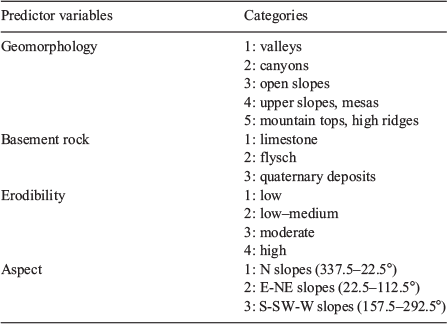
To detect vegetation cover changes before and after the fire event, cross-tabulation analysis was performed in R statistical software (R Core Team 2017) using the gmodels package (Warnes et al. 2018) and contingency tables were produced. For this analysis, we used a total of 828 462 polygons of the eight different vegetation types detected within the study area. A chi-squared test was applied to test the null hypothesis of no effects, as well as to compare expected with observed values (Nioti et al. 2015). A logistic regression analysis was performed to determine the effects of landscape variables on the recovery of black pine forest with the binary response variable being ‘recovery of the original vegetation type either occurs or does not occur’ (Pueyo and Alados 2007). Predictor variables were aspect, basement rock, erodibility and geomorphology (Table 2), key landscape features known to influence post-fire regeneration and vegetation dynamics (Röder et al. 2008; Viana-Soto et al. 2017; Vidal-Macua et al. 2017). An intuitive variable classification of the response variable to 0 for non-recovery and to 1 for recovery was applied. For visualisation of the results, we used the R packages arm (Gelman and Su 2016) and effects (Fox 2003).
|
Results
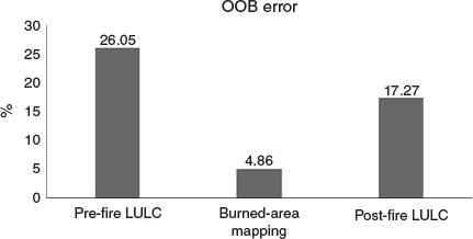
The results of the cross-validation procedure during RF classification model development (Fig. 2) confirmed the complex nature of the landscape under study. The OOB accuracy for the burned area mapping using the Quickbird image was 95.14%, while the lowest prediction accuracy was noted for the pre-fire forest type classification (73.95%). Finally, the results of the RF performance showed good classification accuracy for the post-fire classification of the Worldview-3 image (OOB accuracy 82.73%).
|
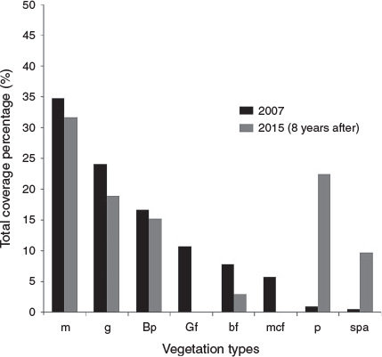
Changes in the distribution and percentage of total cover of different vegetation types 8 years after the 2007 fire event are shown in Figs 3 and 4 as well as in Table 3. The overall changes indicate a decrease in all forest vegetation types from 40% of the total cover to 18%. The most striking difference is the total lack of Abies cephalonica recovery, which is evidenced by the absence of both fir forest stands and mixed-conifer stands 8 years after the fire. Pre-fire Greek fir-dominated forests were converted mostly into grasslands and shrublands, while in some plots, the regeneration level of black pine was higher than that of Greek fir. The area of ground covered by black pine forests did not change substantially after fire (from 16.6 to 15%). This is because of the conversion of mixed-conifer forests or Greek fir-dominated forests into black pine forests due to the lack of regeneration of A. cephalonica. Nevertheless, the level of black pine regeneration was not the same everywhere, with higher densities recorded closer to unburned patches with mature black pine trees. However, there was a remarkable increase in the relative contribution of phrygana (from a percentage cover of 0.7 to 22.3%), with species such as Genista acanthoclada, Sarcopoterium spinosum and Thymbra capitata occupying areas previously covered mostly by grasslands and maquis.

|
|

|
Likewise, sparsely vegetated areas increased from 0.4 to 9.6% of the landscape, demonstrating recovery failure of various vegetation types, including mostly grasslands and Greek fir-dominated forests. In total, 8 years after fire, 72.6% of the burned area was covered either by grasslands or by shrubs, revealing a transition from forest to shrubby vegetation types (i.e. maquis and phrygana) and grasslands. More than 55% of the study area was affected by this transition. Results of Pearson’s chi-square test (665 264.8, d.f. = 35, P < 0.001) and differences between observed and expected values (Table 3) indicate that there is an association between vegetation type before and after the fire event.
At a second stage, we constrained our analysis to coniferous forests, representing the main forest type of the mountain. As no A. cephalonica regeneration was identified, additional statistical analyses were performed only for black pine and mixed-conifer forests. This reduced the initial number of analysis polygons to 49 026. For the same reason, mixed-conifer forests were aggregated to black pine forests and treated as a single category.
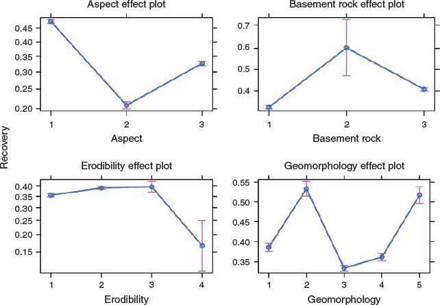
A summary of the logistic regression analysis results is given in Table 4. All four predictor variables are categorical (Table 2). We chose to include the interactions between aspect and erodibility as well as aspect and geomorphology as these were the most meaningful ones. In this analysis, aspect, basement rock type, erodibility and geomorphology were recognised as significant factors affecting the regeneration of black pine on Mount Taygetos. In addition, significant interactions between levels of aspect × erodibility and geomorphology × aspect were identified and are presented in Table 4. In general, eastern and south–south-western aspects had a lower regeneration probability compared with northern orientations (Fig. 5). Canyons and mountain tops had a higher regeneration probability in contrast to open and upper slopes. Overall, the interpretation for coefficients of categorical variables is somewhat different from that of numerical ones and may be understood with an example from Table 4. Having a background geomorphology of type 2 (i.e. canyons) vs type 1 (i.e. valleys) changes – increases because the coefficient is positive – the log odds of Pinus nigra recovery by 0.40. All coefficients for the effect of different types of the categorical variables on the outcome are presented in comparison with the base type of each variable.

|
|
Discussion
Eight years after Mount Taygetos wildfire, combined results of RS- and GIS-based analyses and field measurements indicate a widespread transition from forest to shrubby vegetation types, namely maquis and phrygana or to grasslands and sparsely vegetated areas. The nature of this transition depends on the dominant tree species before the fire event, as well as on the spatial configuration of the burned area. For both conifer species (Pinus nigra and Abies cephalonica), distance from unburned patches with mature trees that can contribute to the post-fire forest recovery through seed dispersal is of paramount importance after high-intensity crown fires (Ordóñez et al. 2006; Christopoulou et al. 2014, 2018; Raftoyannis and Spanos 2015). Black pine, in contrast to Greek fir, can withstand low-intensity surface fires, owing to its thick bark (Tapias et al. 2001, 2004; Pausas et al. 2008). Decreasing natural regeneration after wildfires has been recorded for conifer species in many temperate-zone forests (e.g. Stevens-Rumann et al. 2018) and is mostly attributed to reduced seed availability in the case of large stand-replacing fires (Harvey et al. 2016; Rother and Veblen 2016; Welch et al. 2016; Shive et al. 2018; Stevens-Rumann et al. 2018). The 2007 wildfire did not burn the landscape in a homogeneous way, resulting in the presence of unburned patches of various sizes within the periphery of the burned area. These patches could contribute to post-fire Greek fir recovery through seed dispersal to the burned areas and subsequent seed germination (Arianoutsou et al. 2010). In such cases, provided that the distance from the unburned mature Greek fir stands is less than 100 m, there is a chance of A. cephalonica regeneration (Christopoulou et al. 2018). Nevertheless, even in these cases, post-fire recovery of Greek fir is expected to be a lengthy process (Ganatsas et al. 2012; Christopoulou et al. 2018). Another factor that may affect the total seed availability for the Greek fir is its masting behaviour, expressed with high interannual variability in the number of adult trees bearing cones, as well as in cones produced per tree and viable seeds per cone (Politi et al. 2011), The lack of suitable microhabitats for seedling establishment in the post-fire open habitat may further limit Greek fir post-fire recovery (Ganatsas et al. 2012; Raftoyannis and Spanos 2015; Christopoulou et al. 2018), as has also been found for other fire-sensitive conifer species (e.g. Stevens-Rumann et al. 2018). However, the faster growth rate and better colonisation capacity of P. nigra in burned areas where unburned patches of both species are present at fairly small distances (Arianoutsou et al. 2010) allows us to claim that wildfires may lead to shifts in vegetation composition.
Focusing on black pine forests, it seems that geomorphology can greatly affect post-fire recovery. Erosion and subsequent soil loss are generally the dominant surface processes on landscapes (Bryan 2000). However, better recovery of P. nigra was recorded in canyons and on mountain tops and high ridges of the study area. This is in general agreement with previous studies of P. nigra (e.g. Sass et al. 2012). Seedlings and saplings of P. nigra established at higher elevations are subjected to lower drought stress because of the prevailing lower temperatures during the summer period. This has been reported for the same species in previous studies (Christopoulou et al. 2014) and for other pine species in the Mediterranean Basin (Viana-Soto et al. 2017) and elsewhere (Rother and Veblen 2016). Better post-fire recovery in canyons may be partly explained by the anemochorous seed dispersal mode of P. nigra, whose seeds have a low seed wind-loading index (Richardson et al. 1990) and may be transported appreciable distances by wind and deposited in the lower parts of the landscape (Thompson and Katul 2009). Seed movement by water and gravity may also explain this pattern. Moreover, in canyons, deeper soils and wetter conditions are expected, facilitating seed germination and subsequent seedling survival.
In terms of the correlation between post-fire recovery and basement rock, it appears that more favourable conditions were observed over the clastic sedimentary lithologies, such as flysch layers. Forest recovery was also higher in areas where the parent basement rock consisted of flysch or quaternary deposits, as the lower bulk density of the soils and the easier access of roots to lower layers allow access to resources such as water and nutrients. Sites with low–medium or moderate erodibility (classes 2 and 3), based on Nakos (1979), showed a higher recovery, indicating probably better soil conditions, but on highly erodible sites (class 4), the recovery probability was qualitatively lower, although the difference was not statistically significant. This can be attributed to the impermeability of clastic rock types (e.g. flysch, schist) and consequently the ability to retain water, especially in the near-surface layers. Limestone and other types of solid rocks make much less contribution to soil production and host shallower soil layers, especially when combined with steep slopes where the ability to retain locally produced soil is reduced. Conditions after a fire event can be even worse because vegetation cover is temporarily minimised and thus the retention of soil in situ is reduced (Pelletier 2017). Essentially, a fire event on a steep limestone slope could create a barren landscape with the basement rock exposed (Diakakis et al. 2017; Farangitakis et al. 2017). In such conditions, it is highly unfavourable to any post-fire regeneration taking place, especially for obligate seeders.
In relation to aspect, post-fire recovery was found to be higher on north-facing slopes, as has also been found elsewhere (Rother and Veblen 2016; Welch et al. 2016). North-facing slopes are generally moister, whereas eastern, south and south-western aspects are exposed to higher heat loads (McCune and Keon 2002), leading to more severe drought stress. These findings agree with Fyllas et al. (2008), who found that P. nigra was more abundant on north-facing slopes, whereas Pinus brutia prevailed on lower, drier and southern-oriented aspects. Although P. nigra can experience reduced regeneration under drier microenvironmental conditions (Fyllas et al. 2008), in the current study, it seems that the species is likely to increase its relative abundance compared with A. cephalonica. This confirms the suggestion made by Arianoutsou et al. (2010) that in burned areas where stands of the two species are found in quite close quarters, black pine could potentially invade sites previously dominated by fir.
The patches covered by short seasonal dimorphic shrubs (phrygana) most probably reflect the result of repeated fires that have happened in the study area during the last 165 years (Christopoulou et al. 2013), and which did not allow the recovery of the initial forest vegetation. The expansion of phrygana may be attributed to the ability of those species to withstand fire and become more abundant in cases where the canopy tree cover fails to recover (Arianoutsou–Faraggitaki 1984).
With regard to our combined RS and GIS analyses, the highest OOB accuracy was obtained in our burned mapping (the Quickbird image classification) owing to the binary classification scheme and the profound changes in the spectral response between burned and unburned areas. This is due to the modification of the composition and moisture content of the aboveground vegetation and char and ash deposition after fire, resulting in substantial differences in the spectral profiles between adjacent burned and unburned areas, thus facilitating discrimination and classification (Mallinis and Koutsias 2012). However, the lower prediction accuracy of the pre-fire classification of the forest types in the area, although deemed satisfactory based on accuracy standards for vegetation mapping (Rudnicki et al. 2015), can be attributed to the fact that the pre-fire landscape in the area is complex, with an intermix of vegetation types with similar spectral signatures (i.e. Greek fir-dominated forests, mixed-conifer forests and black pine forests).
The higher accuracy of the post-fire classification compared with the pre-fire vegetation map is also likely related both to the refined spectral information (compared with other VHR sensors) recorded by the Worldview-3 sensor, which provides eight multispectral bands over the 400–900 nm spectral range and to the non-existence of A. cephalonica in the post-fire landscape.
Conclusions
Our study provides evidence that landscape characteristics are influencing post-fire vegetation recovery on Mount Taygetos. Such evidence can be of paramount importance for the evaluation of the resilience of different vegetation types, as well as for the identification of vulnerable sites within the burned area and of sites needing human-aided restoration. Future studies addressing similar questions coupled with fire severity information could contribute to the assessment of ecosystem vulnerability to changing fire regimes induced by global change and greatly support adaptive forest management (Lloret et al. 2002; Moreira et al. 2011; Duguy et al. 2012; Torres et al. 2017; Moya et al. 2018).
Remote sensing techniques have been extensively employed in studies related to fire effects on ecosystems and monitoring in various biomes at local, regional and global scales. Several methods have been developed, from the fairly common burned area mapping to more challenging tasks such as tracking forest successional stages and recovery patterns (Chu and Guo 2014). Despite the advantages that RS techniques have over traditional field sampling methods, more robust approaches and methods need to be further developed. Our use of GEOBIA combined with very high spatial resolution images proved to be very effective in the present study, as it provided spatially explicit and unbiased representation of pre- and post-fire forest patterns and improved the accuracy of forest recovery modelling. As has been suggested in other studies, time series of high-resolution images can enhance monitoring results of post-fire recovery (Vanderhoof et al. 2018), but their high cost remains a serious restriction for forest managers.
Conflicts of interest
The authors declare no conflicts of interest.
Acknowledgements
This research was partly financed by the European project FUME (grant agreement no. 7243888). The authors express their deep acknowledgements to the three anonymous reviewers for their valuable comments, which greatly improved the manuscript.
References
Arianoutsou M, Ne’eman G (2000) Post-fire regeneration of natural Pinus halepensis forests in the east Mediterranean Basin. In ‘Ecology, biogeography and management of Pinus halepensis and Pinus brutia forest ecosystems in the Mediterranean Basin’. (Eds G Ne’eman and L Trabaud) pp. 269–289. (Backhuys Publishers: Leiden, The Netherlands).Arianoutsou M, Christopoulou A, Kazanis D, Tountas Th, Ganou E, Bazos I, Kokkoris I (2010) Effects of fire on high altitude coniferous forests of Greece. In ‘Proceedings of the VI international conference on forest fire research’,15-18 November 2010, Coimbra, Portugal (Ed DX Viegas). CD-ROM.
Arianoutsou–Faraggitaki M (1984) Post-fire successional recovery of a phryganic (east Mediterranean) ecosystem. Acta Oecologica 59, 387–394.
Arnan X, Rodrigo A, Retana J (2007) Post-fire regeneration of Mediterranean plant communities at a regional scale is dependent on vegetation type and dryness. Journal of Vegetation Science 18, 111–122.
| Post-fire regeneration of Mediterranean plant communities at a regional scale is dependent on vegetation type and dryness.Crossref | GoogleScholarGoogle Scholar |
Belgiu M, Drăgu L, Drăguţ L (2016) Random forest in remote sensing: a review of applications and future directions. ISPRS Journal of Photogrammetry and Remote Sensing 114, 24–31.
| Random forest in remote sensing: a review of applications and future directions.Crossref | GoogleScholarGoogle Scholar |
Blaschke T (2010) Object-based image analysis for remote sensing ISPRS Journal of Photogrammetry and Remote Sensing 65, 2–16.
| Object-based image analysis for remote sensingCrossref | GoogleScholarGoogle Scholar |
Bonneau M (1984) Correlation of the Hellenide nappes in the south-east Aegean and their tectonic reconstruction. Geological Society, London, Special Publications 17, 517–527.
| Correlation of the Hellenide nappes in the south-east Aegean and their tectonic reconstruction.Crossref | GoogleScholarGoogle Scholar |
Breiman L (2001) Random forest Machine Learning 5, 32
| Random forestCrossref | GoogleScholarGoogle Scholar |
Bryan R (2000) Soil erodibility and processes of water erosion on hillslope. Geomorphology 32, 385–415.
| Soil erodibility and processes of water erosion on hillslope.Crossref | GoogleScholarGoogle Scholar |
Catry FX, Rego F, Moreira F, Fernandes PM, Pausas J (2010) Post-fire tree mortality in mixed forests of central Portugal. Forest Ecology and Management 260, 1184–1192.
| Post-fire tree mortality in mixed forests of central Portugal.Crossref | GoogleScholarGoogle Scholar |
Christopoulou A, Fulé PZ, Andriopoulos P, Sarris D, Arianoutsou M (2013) Dendrochronology-based fire history of Pinus nigra forests in Mt Taygetos, Peloponnese, Greece. Forest Ecology and Management 293, 132–139.
| Dendrochronology-based fire history of Pinus nigra forests in Mt Taygetos, Peloponnese, Greece.Crossref | GoogleScholarGoogle Scholar |
Christopoulou A, Fyllas NM, Andriopoulos P, Koutsias N, Dimitrakopoulos PG, Arianoutsou M (2014) Post-fire regeneration patterns of Pinus nigra in a recently burned area in Mount Taygetos, southern Greece: the role of unburned forest patches. Forest Ecology and Management 327, 148–156.
| Post-fire regeneration patterns of Pinus nigra in a recently burned area in Mount Taygetos, southern Greece: the role of unburned forest patches.Crossref | GoogleScholarGoogle Scholar |
Christopoulou A, Kazanis D, Fyllas NM, Arianoutsou M (2018) Post-fire recovery of Abies cephalonica forest communities: the case of Mt Parnitha National Park, Attica, Greece. IForest 11, 757–764.
| Post-fire recovery of Abies cephalonica forest communities: the case of Mt Parnitha National Park, Attica, Greece.Crossref | GoogleScholarGoogle Scholar |
Chu T, Guo X (2014) Remote sensing techniques in monitoring post-fire effects and patterns of forest recovery in boreal forest regions: a review. Remote Sensing 6, 470–520.
| Remote sensing techniques in monitoring post-fire effects and patterns of forest recovery in boreal forest regions: a review.Crossref | GoogleScholarGoogle Scholar |
Chuvieco E, Mouillot F, van der Werf GR, San Miguel J, Tanase M, Koutsias N, García M, Yebra M, Padilla M, Gitas I, Heil A, Hawbaker TJ, Giglio L (2019) Historical background and current developments for mapping burned area from satellite Earth observation. Remote Sensing of Environment 225, 45–64.
| Historical background and current developments for mapping burned area from satellite Earth observation.Crossref | GoogleScholarGoogle Scholar |
Coppin P, Jonckheere I, Nackaerts K, Muys B, Lambin E (2004) Digital change detection methods in ecosystem monitoring: a review. International Journal of Remote Sensing 25, 1565–1596.
| Digital change detection methods in ecosystem monitoring: a review.Crossref | GoogleScholarGoogle Scholar |
Dafis S, Papastergiadou E, Georghiou K, Babalonas D, Georgiadis T, Papageorgiou M, Lazaridou Th, Tsiaoussi V (1996) Directive 92/43/EEC. The Greek ‘Habitat’ Project NATURA 2000: an overview. Life contract B4–3200/84/756, Commission of the European Communities DG XI, The Goulandris Natural History Museum – Greek Biotope/Wetland Centre. Thessaloniki, Greece.
de Zea Bermudez P, Mendes J, Pereira JMC, Turkman KF, Vasconcelos MJP (2009) Spatial and temporal extremes of wildfire sizes in Portugal. International Journal of Wildland Fire 18, 983–991.
| Spatial and temporal extremes of wildfire sizes in Portugal.Crossref | GoogleScholarGoogle Scholar |
Diakakis M, Nikolopoulos EI, Mavroulis S, Vassilakis E, Korakaki E (2017) Observational evidence on the effects of mega-fires on the frequency of hydrogeomorphic hazards. The case of the Peloponnese fires of 2007 in Greece. The Science of the Total Environment 592, 262–276.
| Observational evidence on the effects of mega-fires on the frequency of hydrogeomorphic hazards. The case of the Peloponnese fires of 2007 in Greece.Crossref | GoogleScholarGoogle Scholar | 28319713PubMed |
Diaz-Delgado R, Pons X (2001) Spatial patterns of forest fires in Catalonia (NE of Spain) along the period 1975–1995. Analysis of vegetation recovery after fire. Forest Ecology and Management 147, 67–74.
| Spatial patterns of forest fires in Catalonia (NE of Spain) along the period 1975–1995. Analysis of vegetation recovery after fire.Crossref | GoogleScholarGoogle Scholar |
Diaz-Delgado R, Lloret F, Pons X (2004) Spatial patterns of fire occurrence in Catalonia, NE, Spain. Landscape Ecology 19, 731–745.
| Spatial patterns of fire occurrence in Catalonia, NE, Spain.Crossref | GoogleScholarGoogle Scholar |
Duguy B, Alloza JA, Baeza MJ, De la Riva J, Echeverría M, Ibarra P, Llovet J, Cabello FP, Rovira P, Vallejo RV (2012) Modelling the ecological vulnerability to forest fires in Mediterranean ecosystems using geographic information technologies. Environmental Management 50, 1012–1026.
| Modelling the ecological vulnerability to forest fires in Mediterranean ecosystems using geographic information technologies.Crossref | GoogleScholarGoogle Scholar | 23052472PubMed |
European Commission (2017) Forest fires in Europe, Middle East and North Africa 2016. Joint Research Center Science for Policy Report. EUR 28707 EN. Publications Office of the European Union, Luxembourg,
Farangitakis GP, Christopoulou A, Vassilakis E, Papanikolaou I, Arianoutsou M (2017) Do landscape properties affect the process of post-fire vegetation recovery? A case study from the Taygetos Mountain, Greece. In ‘Proceedings of XIV MEDECOS & XIII AEET meeting’, 31 January–4 February 2017, Seville, Spain. p. 114, Doi.: 10.7818/MEDECOSandAEETCongress.2017 (Asociación Española de Ecología Terrestre (AEET), Madrid, Spain)
Fox J (2003) Effect displays in R for generalised linear models. Journal of Statistical Software 8, 1–27.
| Effect displays in R for generalised linear models.Crossref | GoogleScholarGoogle Scholar |
Fyllas NM, Troumbis AY (2009) Simulating vegetation shifts in north-eastern Mediterranean mountain forests under climatic change scenarios. Global Ecology and Biogeography 18, 64–77.
| Simulating vegetation shifts in north-eastern Mediterranean mountain forests under climatic change scenarios.Crossref | GoogleScholarGoogle Scholar |
Fyllas NM, Dimitrakopoulos PG, Troumbis AY (2008) Regeneration dynamics of a mixed Mediterranean pine forest in the absence of fire. Forest Ecology and Management 256, 1552–1559.
| Regeneration dynamics of a mixed Mediterranean pine forest in the absence of fire.Crossref | GoogleScholarGoogle Scholar |
Ganatsas P, Daskalakou E, Paitaridou D (2012) First results on early post-fire succession in an Abies cephalonica forest (Parnitha National Park, Greece). IForest 5, 6–12.
| First results on early post-fire succession in an Abies cephalonica forest (Parnitha National Park, Greece).Crossref | GoogleScholarGoogle Scholar |
Gelman A, Su Y-S (2016) arm: data analysis using regression and multilevel/hierarchical models. R package version 1.9–3. Available at https://CRAN.R-project.org/package=arm[Verified 12 June 2019]
Gill AM, Allan G (2008) Large fires, fire effects and the fire regime concept. International Journal of Wildland Fire 17, 688–695.
| Large fires, fire effects and the fire regime concept.Crossref | GoogleScholarGoogle Scholar |
González-De Vega S, de las Heras J, Moya D (2018) Post-fire regeneration and diversity response to burn severity in Pinus halepensis Mill. forests. Forests 9, 299
| Post-fire regeneration and diversity response to burn severity in Pinus halepensis Mill. forests.Crossref | GoogleScholarGoogle Scholar |
Harvey BJ, Donato DC, Turner MG (2016) High and dry: post-fire tree seedling establishment in subalpine forests decreases with post-fire drought and large stand-replacing burn patches. Global Ecology and Biogeography 25, 655–669.
| High and dry: post-fire tree seedling establishment in subalpine forests decreases with post-fire drought and large stand-replacing burn patches.Crossref | GoogleScholarGoogle Scholar |
Jenness J (2006) Topographic position index (tpi_jen.avx) extension for ArcView 3.x, v. 1.2. (Jenness Enterprises). Available at http://www.jennessent.com/arcview/tpi.htm [Verified 12 June 2019]
Jolivet L, Trotet F, Monié P, Vidal O, Goffé B, Labrousse L, Agard P, Ghorbal B (2010) Along-strike variations of P-T conditions in accretionary wedges and syn-orogenic extension, the HP-LT phyllite–quartzite nappe in Crete and the Peloponnese. Tectonophysics 480, 133–148.
| Along-strike variations of P-T conditions in accretionary wedges and syn-orogenic extension, the HP-LT phyllite–quartzite nappe in Crete and the Peloponnese.Crossref | GoogleScholarGoogle Scholar |
Kalabokidis K, Palaiologou P, Gerasopoulos E, Giannakopoulos C, Kostopoulou E, Zerefos C (2015) Effect of climate change projections on forest fire behavior and values-at-risk in south-western Greece. Forests 6, 2214–2240.
| Effect of climate change projections on forest fire behavior and values-at-risk in south-western Greece.Crossref | GoogleScholarGoogle Scholar |
Karali A, Hatzaki M, Giannakopoulos C, Roussos A, Xanthopoulos G, Tenentes V (2014) Sensitivity and evaluation of current fire risk and future projections due to climate change: the case study of Greece. Natural Hazards and Earth System Sciences 14, 143–153.
| Sensitivity and evaluation of current fire risk and future projections due to climate change: the case study of Greece.Crossref | GoogleScholarGoogle Scholar |
Koutsias N, Arianoutsou M, Kallimanis AS, Mallinis G, Halley JM, Dimopoulos P (2012) Where did the fires burn in Peloponnisos, Greece, the summer of 2007? Evidence for a synergy of fuel and weather. Agricultural and Forest Meteorology 156, 41–53.
| Where did the fires burn in Peloponnisos, Greece, the summer of 2007? Evidence for a synergy of fuel and weather.Crossref | GoogleScholarGoogle Scholar |
Lentile LB, Holden ZA, Smith AMS, Falkowski MJ, Hudak AT, Morgan P, Lewis SA, Gessler PE, Benson NC (2006) Remote sensing techniques to assess active fire characteristics and post-fire effects. International Journal of Wildland Fire 15, 319–345.
| Remote sensing techniques to assess active fire characteristics and post-fire effects.Crossref | GoogleScholarGoogle Scholar |
Lloret F, Marí G (2001) A comparison of the medieval and the current fire regimes in managed pine forests of Catalonia (NE Spain). Forest Ecology and Management 141, 155–163.
| A comparison of the medieval and the current fire regimes in managed pine forests of Catalonia (NE Spain).Crossref | GoogleScholarGoogle Scholar |
Lloret F, Calvo E, Pons X, Diaz-Delgado R (2002) Wildfires and landscape patterns in the eastern Iberian Peninsula. Landscape Ecology 17, 745–759.
| Wildfires and landscape patterns in the eastern Iberian Peninsula.Crossref | GoogleScholarGoogle Scholar |
López-Poma R, Bautista S (2014) Plant regeneration functional groups modulate the response to fire of soil enzyme activities in a Mediterranean shrubland. Soil Biology & Biochemistry 79, 5–13.
| Plant regeneration functional groups modulate the response to fire of soil enzyme activities in a Mediterranean shrubland.Crossref | GoogleScholarGoogle Scholar |
Mallinis G, Koutsias N (2012) Comparing ten classification methods for burned area mapping in a Mediterranean environment using Landsat TM satellite data. International Journal of Remote Sensing 33, 4408–4433.
| Comparing ten classification methods for burned area mapping in a Mediterranean environment using Landsat TM satellite data.Crossref | GoogleScholarGoogle Scholar |
Mallinis G, Mitsopoulos I, Beltran E, Goldammer JG (2016) Assessing wildfire risk in cultural heritage properties using satellite imagery and spatially explicit fire simulations: the case of Holy Mount Athos, Greece Forests 7, 1–19.
| Assessing wildfire risk in cultural heritage properties using satellite imagery and spatially explicit fire simulations: the case of Holy Mount Athos, GreeceCrossref | GoogleScholarGoogle Scholar |
Mallinis G, Mitsopoulos I, Chrysafi I (2018) Evaluating and comparing Sentinel 2A and Landsat-8 Operational Land Imager (OLI) spectral indices for estimating fire severity in a Mediterranean pine ecosystem of Greece. GIScience & Remote Sensing 55, 1–18.
| Evaluating and comparing Sentinel 2A and Landsat-8 Operational Land Imager (OLI) spectral indices for estimating fire severity in a Mediterranean pine ecosystem of Greece.Crossref | GoogleScholarGoogle Scholar |
McCune B, Keon D (2002) Equations for potential annual direct incident radiation and heat load. Journal of Vegetation Science 13, 603–606.
| Equations for potential annual direct incident radiation and heat load.Crossref | GoogleScholarGoogle Scholar |
Meng R, Dennison PE, Huang C, Moritz MA, D’Antonio C (2015) Effects of fire severity and post-fire climate on short-term vegetation recovery of mixed-conifer and red fir forests in the Sierra Nevada Mountains of California. Remote Sensing of Environment 171, 311–325.
| Effects of fire severity and post-fire climate on short-term vegetation recovery of mixed-conifer and red fir forests in the Sierra Nevada Mountains of California.Crossref | GoogleScholarGoogle Scholar |
Mitsopoulos I, Mallinis G (2017) A data-driven approach to assess large fire size generation in Greece Natural Hazards 88, 1591–1607.
| A data-driven approach to assess large fire size generation in GreeceCrossref | GoogleScholarGoogle Scholar |
Moreira F, Viedma O, Arianoutsou M, Curt T, Koutsias N, Rigolot E, Barbati A, Corona P, Vaz P, Xanthopoulos G, Mouillot F, Bilgili E (2011) Landscape–wildfire interactions in southern Europe: implications for landscape management. Journal of Environmental Management 92, 2389–2402.
| Landscape–wildfire interactions in southern Europe: implications for landscape management.Crossref | GoogleScholarGoogle Scholar | 21741757PubMed |
Moriondo M, Good P, Durao R, Bindi M, Giannakopoulos C, Corte-Real J (2006) Potential impact of climate change on fire risk in the Mediterranean area. Climate Research 31, 85–95.
| Potential impact of climate change on fire risk in the Mediterranean area.Crossref | GoogleScholarGoogle Scholar |
Moritz MA, Morais ME, Summerell LA, Carlson JM, Doyle J (2005) Wildfires, complexity, and highly optimized tolerance. Proceedings of the National Academy of Sciences of the United States of America 102, 17912–17917.
| Wildfires, complexity, and highly optimized tolerance.Crossref | GoogleScholarGoogle Scholar | 16332964PubMed |
Moya D, González-de Vega S, García-Orenes F, Morugán-Coronado A, Arcenegui V, Mataix-Solera J, Lucas-Borja ME, de las Heras J (2018) Temporal characterisation of soil–plant natural recovery related to fire severity in burned Pinus halepensis Mill. forests. The Science of the Total Environment 640–641, 42–51.
| Temporal characterisation of soil–plant natural recovery related to fire severity in burned Pinus halepensis Mill. forests.Crossref | GoogleScholarGoogle Scholar | 29852446PubMed |
Nakos G (1979) Forest soils of Greece: physical, chemical and biological properties. Forest Ecology and Management 2, 35–51.
| Forest soils of Greece: physical, chemical and biological properties.Crossref | GoogleScholarGoogle Scholar |
Nioti F, Xystrakis F, Koutsias N, Dimopoulos P (2015) A remote sensing and GIS approach to study the long-term vegetation recovery of a fire-affected pine forest in southern Greece. Remote Sensing 7, 7712–7731.
| A remote sensing and GIS approach to study the long-term vegetation recovery of a fire-affected pine forest in southern Greece.Crossref | GoogleScholarGoogle Scholar |
Ordóñez JL, Molowny-Horas R, Retana J (2006) A model of the recruitment of Pinus nigra from unburned edges after large wildfires. Ecological Modelling 197, 405–417.
| A model of the recruitment of Pinus nigra from unburned edges after large wildfires.Crossref | GoogleScholarGoogle Scholar |
Papanikolaοu ID, Roberts GP, Deligiannakis G, Sakellariou A, Vassilakis E (2013) The Sparta Fault, southern Greece: from segmentation and tectonic geomorphology to seismic hazard mapping and time-dependent probabilities. Tectonophysics 597–598, 85–105.
| The Sparta Fault, southern Greece: from segmentation and tectonic geomorphology to seismic hazard mapping and time-dependent probabilities.Crossref | GoogleScholarGoogle Scholar |
Pausas JG, Fernández-Muñoz S (2012) Fire regime changes in the western Mediterranean Basin: from fuel-limited to drought-driven fire regime. Climatic Change 110, 215–226.
| Fire regime changes in the western Mediterranean Basin: from fuel-limited to drought-driven fire regime.Crossref | GoogleScholarGoogle Scholar |
Pausas JG, Keeley JE (2009) A burning story: the role of fire in the history of life. Bioscience 59, 593–601.
| A burning story: the role of fire in the history of life.Crossref | GoogleScholarGoogle Scholar |
Pausas JG, Carbó E, Caturla RN, Gil JM, Vallejo R (1999) Post-fire regeneration patterns in the eastern Iberian Peninsula. Acta Oecologica 20, 499–508.
| Post-fire regeneration patterns in the eastern Iberian Peninsula.Crossref | GoogleScholarGoogle Scholar |
Pausas JG, Bradstock RA, Keith DA, Keeley JE (2004) Plant functional traits in relation to fire in crown-fire ecosystems. Ecology 85, 1085–1100.
| Plant functional traits in relation to fire in crown-fire ecosystems.Crossref | GoogleScholarGoogle Scholar |
Pausas JG, Llovet J, Rodrigo A, Vallejo R (2008) Are wildfires a disaster in the Mediterranean basin? A review. International Journal of Wildland Fire 17, 713–723.
| Are wildfires a disaster in the Mediterranean basin? A review.Crossref | GoogleScholarGoogle Scholar |
Pelletier JD (2017) Quantifying the controls on potential soil production rates: a case study of the San Gabriel Mountains, California. Earth Surface Dynamics 5, 479–492.
| Quantifying the controls on potential soil production rates: a case study of the San Gabriel Mountains, California.Crossref | GoogleScholarGoogle Scholar |
Peñuelas J, Sardans J, Fillela I, Estiarte M, Llusià J, Ogaya R, Carnicer J, Bartrons M, Rivas-Ubach A, Grau O, Peguero G, Margalef O, Pla-Rabés S, Stefanescu C, Asensio D, Preece C, Liu L, Verger A, Barbeta A, Achotegui-Castells A, Gargallo-Garriga A, Sperlich D, Farré-Armengol G, Fernández-Martínez M, Liu D, Zhang C, Urbina I, Camino-Serrano M, Vives-Ingla M, Stocker BD, Balzarolo M, Guerrieri R, Peaucelle M, Marañón-Jiménez S, Bórnez-Mejías K, Mu Z, Descals A, Castellanos A, Terradas J (2017) Impact of global change on Mediterranean forests and their services. Forests 8, 463
| Impact of global change on Mediterranean forests and their services.Crossref | GoogleScholarGoogle Scholar |
Poirazidis K, Zografou K, Kordopatis P, Kalivas DP, Arianoutsou M, Kazanis D, Korakaki E (2012) A GIS-based integrated approach predicts accurately post-fire Aleppo pine regeneration at regional scale. Annals of Forest Science 69, 519–529.
| A GIS-based integrated approach predicts accurately post-fire Aleppo pine regeneration at regional scale.Crossref | GoogleScholarGoogle Scholar |
Politi PI, Georghiou K, Arianoutsou M (2011) Reproductive biology of Abies cephalonica Loudon in Mount Aenos National Park, Cephalonia, Greece. Trees 25, 655–668.
| Reproductive biology of Abies cephalonica Loudon in Mount Aenos National Park, Cephalonia, Greece.Crossref | GoogleScholarGoogle Scholar |
Psonis K (1986) Geological map of Greece, 1 : 50 000, sheet Kalamai. (Institute of Geology and Mineral Exploration: Athens, Greece)
Psonis K (1990) Geological map of Greece, 1 : 50 000, sheet Sparti. (Institute of Geology and Mineral Exploration: Athens, Greece)
Pueyo Y, Alados CL (2007) Effects of fragmentation, abiotic factors and land use on vegetation recovery in a semi-arid Mediterranean area. Basic and Applied Ecology 8, 158–170.
| Effects of fragmentation, abiotic factors and land use on vegetation recovery in a semi-arid Mediterranean area.Crossref | GoogleScholarGoogle Scholar |
R Core Team (2017) R: a language and environment for statistical computing. R Foundation for Statistical Computing. (Vienna, Austria). Available at https://www.R-project.org/[Verified 12 June 2019]
Raftoyannis Y, Spanos I (2015) Regeneration of Abies cephalonica Loudon after a large fire in central Greece. South-east European Forestry 6, 5–14.
| Regeneration of Abies cephalonica Loudon after a large fire in central Greece.Crossref | GoogleScholarGoogle Scholar |
Retana J, Espelta JM, Habrouk A, Ordóñez JL, de Solà-Morales F (2002) Regeneration patterns of three Mediterranean pines and forest changes after a large wildfire in north-eastern Spain. Ecoscience 9, 89–97.
| Regeneration patterns of three Mediterranean pines and forest changes after a large wildfire in north-eastern Spain.Crossref | GoogleScholarGoogle Scholar |
Richardson D, Cowling RM, Le Maitre DC (1990) Assessing the risk of invasive success in Pinus and Banksia in South African mountain fynbos. Journal of Vegetation Science 1, 629–642.
| Assessing the risk of invasive success in Pinus and Banksia in South African mountain fynbos.Crossref | GoogleScholarGoogle Scholar |
Röder A, Hill J, Duguy B, Alloza JA, Vallejo R (2008) Using long time series of Landsat data to monitor fire events and post-fire dynamics and identify driving factors. A case study in the Ayora region (eastern Spain). Remote Sensing of Environment 112, 259–273.
| Using long time series of Landsat data to monitor fire events and post-fire dynamics and identify driving factors. A case study in the Ayora region (eastern Spain).Crossref | GoogleScholarGoogle Scholar |
Romkens MJM (1985) The soil erodibility factor: a perspective. In ‘Soil erosion and conservation’. (Eds SA El-Swaify, WC Moldenhauer, A Lo) pp. 445–461. (Soil Conservation Society of America: Ankeny, IA, USA)
Rother MT, Veblen TT (2016) Limited conifer regeneration following wildfires in dry ponderosa pine forests of the Colorado Front Range. Ecosphere 7,
| Limited conifer regeneration following wildfires in dry ponderosa pine forests of the Colorado Front Range.Crossref | GoogleScholarGoogle Scholar |
Rudnicki WR, Wrzesień M, Paja W (2015) All relevant feature selection methods and applications. In ‘Feature selection for data and pattern recognition’. (Eds U Stańczyk, L Jain) Studies in Computational Intelligence, Vol. 584, pp. 11–28. (Springer: Berlin, Germany)
San-Miguel-Ayanz J, Moreno JM, Camia A (2013) Analysis of large fires in European Mediterranean landscapes: lessons learned and perspectives. Forest Ecology and Management 294, 11–22.
| Analysis of large fires in European Mediterranean landscapes: lessons learned and perspectives.Crossref | GoogleScholarGoogle Scholar |
Sass O, Heel M, Leistner I, Stöger F, Wetzel K, Friedmann A (2012) Disturbance, geomorphic processes and recovery of wildfire slopes in North Tyrol. Earth Surface Processes and Landforms 37, 883–894.
| Disturbance, geomorphic processes and recovery of wildfire slopes in North Tyrol.Crossref | GoogleScholarGoogle Scholar |
Shive K, Preisler H, Welch KR, Safford HD, Butz RJ, O’Hara K, Stephens SL (2018) Scaling stand-scale measurements to landscape-scale predictions of forest regeneration after disturbance: the importance of spatial pattern. Ecological Applications 28, 1626–1639.
| Scaling stand-scale measurements to landscape-scale predictions of forest regeneration after disturbance: the importance of spatial pattern.Crossref | GoogleScholarGoogle Scholar | 29809291PubMed |
Silva JS, Rego FC (1999) Establishment of Mediterranean woody species after fire in central Portugal. In ‘Proceeding of the Advanced Study Course on Wildfire management’. (Eds G Eftichidis, P Balabanis, A Ghazi) Marathon, Greece 6–14 October 1997, pp. 487–502 Algosystems SA, Athens, Greece
Stevens-Rumann CS, Kemp KB, Higuera PE, Harney BJ, Rother MT, Donato DC, Morgan P, Veblen TT (2018) Evidence for declining forest resilience to wildfires under climate change. Ecology Letters 21, 243–252.
| Evidence for declining forest resilience to wildfires under climate change.Crossref | GoogleScholarGoogle Scholar | 29230936PubMed |
Tapias R, Gil L, Fuentes-Utrilla P, Pardos JA (2001) Canopy seed banks in Mediterranean pines of south-eastern Spain: a comparison between Pinus halepensis Mill, P. pinaster Ait, P. nigra Arn., and P. pinea L. Journal of Ecology 89, 629–638.
| Canopy seed banks in Mediterranean pines of south-eastern Spain: a comparison between Pinus halepensis Mill, P. pinaster Ait, P. nigra Arn., and P. pinea L.Crossref | GoogleScholarGoogle Scholar |
Tapias R, Climent J, Pardos JA, Gil L (2004) Life histories of Mediterranean pines. Plant Ecology 171, 53–68.
| Life histories of Mediterranean pines.Crossref | GoogleScholarGoogle Scholar |
Tavşanoğlu C (2008) The effect of aspect on post-fire recovery of a mixed Lebanon cedar–Anatolian black pine forest: after the first 5 years. Asian Journal of Plant Sciences 7, 696–699.
| The effect of aspect on post-fire recovery of a mixed Lebanon cedar–Anatolian black pine forest: after the first 5 years.Crossref | GoogleScholarGoogle Scholar |
Thompson S, Katul G (2009) Secondary seed dispersal and its role in landscape organization. Geophysical Research Letters 36, L02402
| Secondary seed dispersal and its role in landscape organization.Crossref | GoogleScholarGoogle Scholar |
Torres J, Marques J, Alves P, Costa H, Honrado J (2017) Local lithological drivers of post-fire vegetation recovery and implications for fire-prone regions. Ecological Research 32, 37–49.
| Local lithological drivers of post-fire vegetation recovery and implications for fire-prone regions.Crossref | GoogleScholarGoogle Scholar |
Turco M, Bedia J, Di Liberto F, Fiorucci P, von Hardenberg J, Koutsias N, Llasat MC, Xystrakis F, Provenzale A (2016) Decreasing fires in Mediterranean Europe. PLoS One 11, e0150663
| Decreasing fires in Mediterranean Europe.Crossref | GoogleScholarGoogle Scholar | 26982584PubMed |
Vanderhoof MK, Burt C, Hawbaker TJ (2018) Time series of high-resolution images enhances efforts to monitor post-fire condition and recovery, Waldo Canyon fire, Colorado, USA. International Journal of Wildland Fire 27, 699–713.
| Time series of high-resolution images enhances efforts to monitor post-fire condition and recovery, Waldo Canyon fire, Colorado, USA.Crossref | GoogleScholarGoogle Scholar |
Viana-Soto A, Aguado I, Martínez S (2017) Assessment of post-fire vegetation recovery using fire severity and geographical data in the Mediterranean region. Environments 4, 90
| Assessment of post-fire vegetation recovery using fire severity and geographical data in the Mediterranean region.Crossref | GoogleScholarGoogle Scholar |
Vidal-Macua JJ, Ninyerola M, Zabala A, Domingo-Marimon C, Pons X (2017) Factors affecting forest dynamics in the Iberian Peninsula from 1987 to 2012. The role of topography and drought. Forest Ecology and Management 406, 290–306.
| Factors affecting forest dynamics in the Iberian Peninsula from 1987 to 2012. The role of topography and drought.Crossref | GoogleScholarGoogle Scholar |
Warnes GR, Bolker B, Lumley T, Johnson RC (2018) gmodels: Various R Programming Tools for Model Fitting. R package version 2.18.1. Available at https://CRAN.R-project.org/package=gmodels[Verified 12 June 2019]
Welch KR, Safford HD, Young TP (2016) Predicting conifer establishment post wildfire in mixed-conifer forests of the North American mediterranean-climate zone. Ecosphere 7, e01609
| Predicting conifer establishment post wildfire in mixed-conifer forests of the North American mediterranean-climate zone.Crossref | GoogleScholarGoogle Scholar |