

A framework for prioritising prescribed burning on public land in Western Australia
Trevor Howard A , Neil Burrows A , Tony Smith A , Glen Daniel B and Lachlan McCaw A CA Department of Biodiversity, Conservation and Attractions, Kensington, WA 6983, Australia.
B Department of Fire and Emergency Services Office of Bushfire Risk Management, Perth, WA 6000, Australia.
C Corresponding author. Email: lachie.mccaw@dbca.wa.gov.au
International Journal of Wildland Fire 29(5) 314-325 https://doi.org/10.1071/WF19029
Submitted: 27 February 2019 Accepted: 20 January 2020 Published: 25 February 2020
Journal Compilation © IAWF 2020 Open Access CC BY-NC-ND
Abstract
A risk-based framework for targeting investment in prescribed burning in Western Australia is presented. Bushfire risk is determined through a risk assessment and prioritisation process. The framework provides principles and a rationale for programming fuel management with indicators to demonstrate that bushfire risk has been reduced to an acceptable level. Indicators provide targets for fuel management that are applicable throughout the state and can be customised to meet local circumstances. The framework identifies eight bushfire risk management zones having broad consistency of land use, fire environment and management approach, which combine to create a characteristic risk profile. Thirteen fuel types based primarily on structural attributes of the vegetation that influence fire behaviour are recognised and used to assign models for fuel accumulation and fire behaviour prediction. Each bushfire risk management zone is divided into fire management areas, based on the management intent. These are areas where fuels will be managed primarily to minimise the likelihood of fire causing adverse impacts on human settlements or critical infrastructure, to reduce the risk of bushfire at the landscape scale or to achieve other land management outcomes. Indicators of acceptable bushfire risk are defined for each fire management area and are modified according to the distribution of assets and potential fire behaviour in the landscape. Risk criteria established in the framework can be converted to spatially represented targets for fuel management in each zone and can be reported against to measure the effectiveness of the fuel management program. In areas where the primary intent is to reduce the risk of bushfire at the landscape scale, managers have flexibility to apply prescribed fire in ways that maintain and enhance ecosystem services, nature conservation and landscape values through variation in the seasonality, intensity and scale of planned burning.
Additional keywords: bushfire, performance targets, risk, zoning.
Introduction
The state of Western Australia occupies an area of 2.6 million km2, making it the second largest country subdivision in the world. Fire has shaped the natural environment of Western Australia over thousands of years and continues to play an important role in maintaining ecosystem processes across a diversity of biomes that range from tall eucalypt forests to arid deserts. However, bushfires can also have detrimental impacts on society and the natural environment and there is a need for a systematic approach to managing the risk that bushfires pose. Bushfire management in Western Australia is a shared responsibility between state and local governments and landowners. The Department of Biodiversity, Conservation and Attractions (DBCA) is the state government agency responsible for bushfire prevention on public land, including conservation reserves, state forests and most unallocated Crown land and the department also has a significant role in bushfire suppression. Other state government agencies have responsibilities for emergency response, bushfire mitigation on other tenures, land use planning and development control, the wellbeing of persons displaced by bushfires and post-incident recovery arrangements. Local government has significant responsibilities, including management of volunteer bushfire brigades and enabling fire management on private property through permits to burn. A variety of factors contribute to an increasing risk of bushfire across Western Australia, including climate variability, population growth and associated development, expanding industrial enterprise and infrastructure, land use change and evolving community expectations and attitudes.
The objective for fire management on public land is to protect communities and natural assets from bushfire (Department of Biodiversity, Conservation and Attractions 2018). This objective derives from and is underpinned by the department’s risk management framework. Risk is defined as the effect of uncertainty on objectives in accordance with the international standard for risk management, ISO 31000: 2018 (International Organization for Standardization 2018) that has been adopted and published as an Australian Standard (Standards Australia 2018). First published in 2009 and revised in 2018, the intent of ISO 31000 is to assist organisations to make good decisions about uncertainty in relation to the pursuit of their objectives (Purdy 2010). The standard provides a set of principles to guide and inform risk management and decision making, and a process for identifying, assessing and treating risk that is applicable at all levels throughout an organisation and its activities. The standard also outlines an organisational framework that is needed to ensure risk management is integrated into all significant functions, processes and decisions of an organisation and supported by leadership, policies, mandate, governance, resources, assurance and continual improvement.
In the context of bushfire management the DBCA engages in a broad range of activities that include interagency cooperation, scientific research, community engagement and education, training and development of staff, maintenance of bushfire detection and response capabilities, arson prevention and investigation programs, and maintenance of effective access tracks and communication networks. Fuel management is also an important tool for mitigating bushfire risk and is achieved through a combination of prescribed burning and mechanical fuel modification techniques, depending on the characteristics of the vegetation and the scale of treatment appropriate in different landscape settings.
For more than five decades, an extensive program of prescribed burning has been a key strategy for managing the bushfire threat in the more densely populated south-west of the state (Burrows and McCaw 2013). Supported by fire preparedness and response activities, prescribed burning has been effective in managing the spatial pattern of fuel accumulation and continuity to limit the extent of unplanned fires and the associated impacts on society and the environment (Boer et al. 2009). However, several serious and damaging bushfires have occurred in the south-west of Western Australia during the past two decades (Keelty 2011, 2012; State Emergency Management Committee 2016a; Nous Group 2016; Ferguson 2016). At the same time, maintaining the program of prescribed burning has proved to be challenging because of changes in the fire environment, organisational arrangements and community attitudes (McCaw 2013; McCaw 2018). In the more remote and sparsely populated areas of the state, fire management has historically received less attention and fewer resources but this is changing (Linton 2019). The past decade has seen rapid expansion in the planned use of fire in tropical savannas for the purposes of biodiversity conservation and carbon abatement (Radford et al. 2015) and growing recognition of the benefits of harnessing fire knowledge held by traditional owners (Wunambal Gaambera Aboriginal Corporation 2010; Burrows 2014; Prober et al. 2016).
As Western Australia develops, and as population, industry and infrastructure in the more remote regions expand, there is a need for greater rigour and consistency in planning and implementing prescribed burning to mitigate the threat of bushfire (Florec et al. 2019). In recognition of the increasing impact of bushfire and the escalating costs of undertaking prescribed burning, a state-level, landscape-scale, risk-based framework has been developed to assist managers determine priority areas for prescribed burning based on potential fire behaviour and assets at risk. This framework aligns with and addresses fuel hazard and risk assessment at the regional, strategic planning level recognised by the National Burning Project (AFAC 2014). It does not address local or site-specific tactical and operational risks associated with prescribed burning such as burn security and air quality. Although the framework addresses the ecological appropriateness of prescribed burn regimes at the regional scale, it does not address ecological responses at the local scale. These matters are dealt with through the annual burn planning process and by specific actions identified in prescribed fire plans that guide operations at the local scale.
This framework builds on earlier risk-based approaches to prioritising risk mitigation actions such as prescribed burning, including a wildfire threat analysis (Muller 1993) and a history of fire management planning processes. Previous approaches were applied primarily to the south-west of the state and development of the current regional risk framework represents a commitment to continual improvement as lessons are learned and advancements are made in science, risk management, strategic planning and business processes. The framework establishes principles and a rationale for programming fuel management and, critically, provides indicators that demonstrate that bushfire risk has been reduced to an acceptable level. The acceptable level of bushfire risk is determined through a risk assessment and prioritisation process. Here, we present an overview of this new, risk-based framework for better targeting investment in prescribed burning.
Principles for managing bushfire risk
The approach presented here for managing bushfire risk is underpinned by eight principles derived from a combination of scientific research, practical experience, community and government expectations and industry best practice.
Bushfire risk management is consistent with the international standard
The regional risk framework commits to applying risk management in a manner that is consistent with AS ISO 31000: 2018 Risk management guidelines (Standards Australia 2018). This involves adherence to the principles of risk management, and applying the risk management process to the identification, assessment and treatment of risk, together with appropriate communication and consultation as well as monitoring of decisions, assumptions, contexts and changes. Reviews, assurance processes and continual improvement will maintain the intent and integrity of the corporate risk management framework and its situation within broader state and national policy contexts.
Fuels are managed to reduce the harm done by bushfire
Managing the fuel available to burn is critical to managing the threat posed by bushfire (McCaw 2013; Burrows and McCaw 2013). The available fuel, and its structure, affect the speed and intensity of a bushfire, which, in turn, determine both its potential to cause damage and suppression difficulty (McCaw et al. 2012; Cheney et al. 2012). Done at appropriate temporal and spatial scales, managing the quantity, structure and distribution of fuel available has been demonstrated to be an effective and efficient way to reduce the severity and extent of damage by bushfires (Boer et al. 2009; McCaw 2013).
Bushfire management puts people first
Fire management on public lands achieves multiple outcomes, but a prime consideration is contributing to Western Australia’s State Core Objectives for emergency risk management (State Emergency Management Committee 2018), especially the following:
people: protect human life and wellbeing
infrastructure: maintain the functionality of infrastructure, particularly key transport infrastructure and utilities required for community health, economic production and effective management of emergencies
environment: protect ecosystems and biodiversity.
Fire management will often contribute to achieving multiple objectives in a complementary manner, but when this is not the case, protection and preservation of human life is the paramount consideration when planning and implementing the fire management program on public lands.
Fuel management does not eliminate risk
Fire management aims to reduce the negative consequences of bushfires rather than prevent their occurrence. Given the importance of fire to maintaining ecosystem health and resilience, it is neither desirable nor feasible to eliminate bushfire from natural landsscapes and it is recognised that both planned and unplanned fire can have benefits. Fuel management aims to reduce risk to an acceptable level by greatly enhancing and supporting the effectiveness of other measures, including bushfire law, fire suppression, urban planning, building codes for fire-prone areas and community preparedness.
There are also risks and costs associated with fuel management, particularly prescribed burning. Fuel management is conducted when and where the risk associated with the activity is deemed to be manageable and is outweighed by the risk of not doing it.
Fuel management is planned
Planning utilises the best available information to ensure fuel management activities are undertaken appropriately and safely, but specifically recognises and addresses uncertainties and assumptions. Planning for fuel management must allow for different land management objectives and social contexts, but follow a consistent process throughout the state and be supported by policies and procedural documentation. To allow for this, fuel management activities are planned at different temporal scales, including strategic (5-year horizon), program (1–3-year horizon) and operational (immediately preceding and during the activity).
Fuel management is integrated
Planning for fuel management must consider the broader landscape context and be compatible with other planning processes and statutory requirements. An important reason for developing and communicating long-, medium- and short-term fuel management plans is to maximise the opportunities for engagement in parallel planning processes, such as those of fire agencies and local governments.
Risk is managed at an appropriate scale
The threshold for acceptable bushfire risk varies across the state in response to factors of climate, vegetation, terrain, land use, population density, assets at risk, social and cultural attitudes towards fire and resource availability. To accommodate this variation in the fire environment, bushfire risk is managed at various spatial and temporal scales (AFAC 2014). A state-wide perspective is important because it informs the appropriate allocation of limited resources across the state’s public lands. Regional and subregional perspectives are also important because they allow a more detailed analysis of risk factors to inform fuel management program planning. Risk management processes are also applied at the scale of individual burns as well as at a range of temporal scales.
Ecological requirements are considered when managing fuel
Fuel management should be undertaken within the ecological tolerances of the environment being managed to avoid undesirable effects such as weed invasion, decline in habitat quality or loss of species that have fire-regime specific attributes (Brown et al. 2016; Wooller et al. 2002; Gosper et al. 2013). In principle, the regular occurrence of high-intensity summer bushfire is considered likely to have deleterious effects on biodiversity (Burrows 2013; Bain et al. 2016) and environmental values, including water quality and carbon stored in woody biomass (Nunes et al. 2018; Volkova et al. 2014; Whitford and McCaw 2019). Conversely, biodiversity is best supported by varying the scale, seasonality and intensity of fire occurrence, within tolerable ranges, to maintain an appropriate mosaic of vegetation floristic and structural states (Burrows 2008). Ecological requirements are a key consideration when developing fuel management programs and prescribed fire plans and the planning process is informed by available information from both published and unpublished sources (e.g. Barrett et al. 2009; Shedley et al. 2018). Fuel management activities required to achieve acceptable levels of bushfire risk may involve short-term trade-offs between effects on elements of the biota (Gosper et al. 2010).
Framework for managing bushfire risk by prescribed burning
The Bushfire Risk Management Framework (Fig. 1) provides a process for prioritising regional-scale investment in prescribed burning to manage bushfire risk on public lands in Western Australia, as described in the Interim State Hazard Plan Fire (State Emergency Management Committee 2017). This is achieved by defining:
bushfire risk and how it is assessed
principles and objectives underpinning bushfire risk management
rationale for fuel management
appropriate strategic planning units for bushfire risk management
a process to determine acceptable levels of bushfire risk across the state, expressed as performance indicators of the effectiveness of the fuel management program.

|
Bushfire suppression is out of the scope of the framework, although preparedness and response arrangements are covered by other departmental plans and interagency arrangements. Although the framework takes account of the distribution of built assets and infrastructure on and in proximity to public lands, standards and processes to manage the location, construction and physical vulnerability of those assets are also out of scope, although the department does contribute to state land use planning and development controls.
Bushfire risk management zones
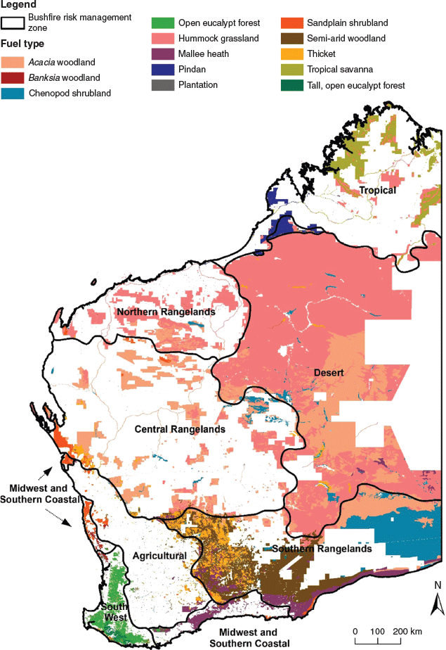
Bushfire risk is highly contextualised because vegetation, climate and land use vary across the state. The framework identifies eight bushfire risk management zones (BRMZ) characterised by broad consistency of land use, asset distribution, fire environment (vegetation, fuels and climate) and fire management practices that combine to create a characteristic risk profile (Fig. 2). The South West zone includes the majority of the state’s population, urban development and infrastructure. The adjoining Agricultural zone and Midwest and Southern Coastal zone include a mixture of agricultural lands and conservation reserves, and together with the South West zone comprise a recognised global biodiversity hotspot (Myers et al. 2000). Beyond this are landscapes dominated by agriculture, pastoralism, mining, Aboriginal lands and unallocated crown land in the Northern, Central and Southern Rangelands and the Tropical zone. These zones feature settlements and nodes of development, often separated by large expanses of land that are economically important but have relatively little infrastructure. The remote Desert zone is characterised by undeveloped arid landscapes that mostly lack infrastructure but support significant biodiversity, cultural, spiritual and tourism values.
|
Fuel types
The framework recognises 13 broad types across Western Australia (Fig. 2). Fuel types are based primarily on structural attributes of the vegetation that influence fire behaviour following the approach of Hollis et al. (2015). For each fuel type, best available information has been assembled regarding post-fire patterns of fuel accumulation, fire ecology, including the requirements of fire sensitive species and communities, harmful fire regimes and fire regimes compatible with ecosystem health. Where possible, the framework assigns each fuel type appropriate fuel accumulation and fire behaviour models (Table 1) and identifies the key weather attributes required to model fire behaviour. These models are used when setting indicators of acceptable bushfire risk, which are defined for different fuels according to the rates of fuel accumulation and the fire behaviour they may support. Where empirically derived fuel accumulation models are not available, expert opinion of local fire practitioners and researchers has been used as a surrogate, pending further studies of fuel characteristics and accumulation leading to an improvement of the framework.

|
Fire management areas
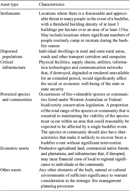
Public lands within each BRMZ are further classified into four fire management areas (FMAs) characterised as Settlement-Hazard Separation, Critical Infrastructure Buffer, Landscape Risk Reduction and Remote Area Management. These FMAs are defined by the primary intent of fuel management, which is a function of potential fire behaviour and the type and distribution of assets characteristic of the area. The framework recognises six classes of assets that may be affected by bushfire: settlements, dispersed populations, critical infrastructure, protected species and communities, economic assets and other assets (non-critical infrastructure, ecological, cultural) (Table 2).
|
The Settlement-Hazard Separation FMA provides an area proximal to settlements where fuels are managed relatively intensively to minimise the likelihood of a bushfire being sustained, damaging properties or endangering people. Here, fuel management to protect settlements takes precedence over other land management objectives, though other land management outcomes can be pursued to the extent that they do not conflict with the primary management intent. The Critical Infrastructure Buffer FMAs are relatively narrow zones of intensive fuel management adjacent to critical infrastructure assets. Critical Infrastructure Buffers apply in fuel types where the most appropriate strategy to protect critical infrastructure from bushfire is localised, rather than landscape-scale, fuel management. The Landscape Risk Reduction FMA comprises areas where dispersed populations, economic assets, susceptible habitat or other significant assets necessitate that fuel is managed at a landscape scale. Fuels are managed to achieve a range of management outcomes, including enabling suppression opportunities that reduce the likelihood of occurrence of large bushfires that may endanger people, damage infrastructure, cause financial or social disruption, degrade the natural environment or require an extended suppression response. By limiting the potential scale and intensity of bushfires the Landscape Risk Reduction FMA also complements more localised protection provided by Settlement-Hazard Separation and Critical Infrastructure Buffer FMAs.
Areas of public land where remoteness, inaccessibility, resource constraints and a lack of consequential assets make it impractical or unnecessary to intervene in the prevailing fire regimes are classified as Remote Area Management FMA. Fuel management activities are a lower priority in these areas but may still be undertaken to achieve land management outcomes for nature conservation and protection of environmental and cultural values, where resources allow.
The extent of the area described by each FMA varies according to the fuel type and the BRMZ in which it occurs (Table 3). The breadth of the Settlement-Hazard Separation FMA is calculated to be sufficient to significantly reduce the likelihood of damage to assets from direct flame contact, radiant heat and ember attack and to provide adequate opportunity for fire suppression. This calculation is based on a combination of data derived from fire behaviour models and expert practitioner judgement. The Settlement-Hazard Separation FMAs are the largest in forest fuels that are prone to long-range spotting, severe ember storms and crown fire behaviour (Sullivan 2017). Narrower Settlement-Hazard Separation FMAs apply in shrub-dominated fuels and grasslands where spotting is limited to short distances and the lower height of the vegetation limits potential flame length. Critical infrastructure assets are typically less vulnerable to spotting and ember attack than is the case for settlements and dimensions are specified to ensure that assets are not exposed to a Bushfire Attack Level (BAL) of greater than BAL-LOW as determined by the methodology provided in AS 3959–2009 (Standards Australia 2009). This is 50 m in grasslands and 100 m in all other flammable fuel types.

|
In the Landscape Risk Reduction FMA the bushfire risk management intent is to reduce the potential for large bushfires to develop. This is typically achieved by maintaining a mosaic of fuel ages to reduce the likelihood of fires igniting, to limit potential fire intensities and provide improved opportunities for safe and effective fire suppression (McCarthy et al. 2012; Plucinski et al. 2012; McCaw 2013; Tolhurst and McCarthy 2016). Considerable flexibility exists for planned fire regimes in the Landscape Risk Reduction FMAs to be integrated with land management objectives other than bushfire risk mitigation including nature conservation, silviculture and cultural use of fire by traditional indigenous landowners.
Indicators of acceptable risk
The relative magnitude of the most significant bushfire risks to the state’s core objectives for emergency risk management are determined using the National Emergency Risk Assessment Guidelines (NERAG) (Australian Institute for Disaster Resilience 2015), as described in the State Emergency Management Prevention and Mitigation Procedure (State Emergency Management Committee 2016b). The NERAG guidelines are based on the ISO 31000 risk management process and principles and have been customised for application to the emergency management sector. The risk register of events identified through this process provides a prioritisation for mitigation measures that involve prescribed burning (Table 4).

|
Indicators of acceptable bushfire risk are set for bushfire-prone fuel types in each FMA, except where the management intent means that fuel management is neither required nor appropriate. Indicators are expressed in terms of the proportion of the landscape that is managed such that the treated fuels will not support a head fire of an intensity that precludes effective suppression action under weather conditions corresponding to the 95th percentile fire danger index. Application of 95th percentile conditions to model the potential behaviour of bushfires is widely accepted (e.g. Muller 1993; Heinsch et al. 2009). The 95th percentile conditions vary according to location and whether the grassland fire danger index (GFDI) (CSIRO 1997a) or forest fire danger index (FFDI) (McArthur 1973) is used to quantify fire danger. Weather conditions (air temperature, relative humidity, wind speed) corresponding to the 95th percentile FFDI are identified and used as inputs to fire behaviour models for calculating forward rate of spread and fire intensity (Table 1).
The intent of fuel management is to reduce the quantity and alter the arrangement of fuels such that a bushfire is likely to spread more slowly, burn with lower intensity, be easier to suppress and cause less damage. Potential fire intensity provides a meaningful measure of these attributes. Studies of the effectiveness of fire suppression have identified ranges of fire intensity at which different approaches to suppression are likely to succeed (Burrows 1984; Loane and Gould 1986; Muller 1993; Alexander 2000; Muller 2008). The indicators of acceptable bushfire risk for each FMA require that a proportion of fuel be in a condition such that it will burn with no more than double the intensity at which machine and tanker attack on the head fire is possible under 95th percentile weather conditions. The intensity threshold for machine and tanker attack is doubled because the documented values relate to head fire intensity, whereas operational practice for fire suppression involving direct or parallel attack is to work from a safe anchor point near the tail fire and progressively contain the flanks of the fire before containing the head fire. Most of the suppression effort is therefore undertaken on parts of the fire exhibiting much lower fire intensity than the head fire. Flank fire intensity may be up to 4-fold lower than head fire intensity (Cheney 1981; Catchpole et al. 1992; Alexander 2000), but a more conservative 2-fold factor is used to set the risk indicators. As such, values of 10 000 kW m−1 in grassland and 4000 kW m−1 in all other fuels are described in the framework as the ‘threshold intensity’ for fuel management. Examples of threshold intensity for two representative locations characterised by eucalypt forest fuels in the South West BRMZ are presented in Table 5.

|
The proportion of fuels that must be managed to the threshold intensity in each FMA is defined by the fuel type (Table 3). Boer et al. (2009), Sneeuwjagt (2008) and Burrows and McCaw (2013) have shown that the area burnt by bushfire in forested areas of the south-west of Western Australia increased significantly during periods when the area of prescribed burning fell below ~8% of public lands per annum. This research, combined with firefighters’ experience and expert opinion, has led to the judgement that bushfire risk can be managed to an acceptable level in contiguously vegetated, forested landscapes by maintaining at least 45% of fuels in a condition such that they will not support high-intensity fires that exceed suppression thresholds. In accordance with these findings, the management objective for forested areas of Landscape Risk Reduction FMAs is to maintain 45% of fuel in a condition such that it will burn at less than its threshold intensity under 95th percentile FFDI conditions. In Banksia woodland, sandplain shrubland and thicket fuel types, the proportional target for the Landscape Risk Reduction FMA is 30%. This recognises that fuel-reduced buffers and open-edged burning are effective as management strategies for these fuels and reducing the fuel load across a large proportion of the landscape may be impractical, unnecessary or not cost-effective. The same proportional target has been adopted for plantations of Pinus pinaster, which is the only commercial tree plantation species that is amenable to fuel reduction by prescribed burning. Targets for the Settlement-Hazard Separation and Critical Infrastructure Buffer FMAs are respectively 60% and 50% of flammable fuels in a condition such that it will burn at less than its threshold intensity under 95th percentile FFDI conditions. These more stringent targets reflect the need for targeted fuel management proximal to high value assets.
Discussion
Managing bushfire risk on public lands in the diverse and dynamic environment of Western Australia requires a robust framework and consistent processes to guide investment in prescribed burning. Risk criteria embedded in the framework can be used to develop regional fuel management plans that translate indicators of acceptable risk to spatially represented hectare-based targets for fuel management, based on the fire environment, the nature of fuels and the distribution of assets and values within a BRMZ. Indicators of acceptable bushfire risk described in the framework can be reported against annually to measure the effectiveness of the fuel management program. The framework is aligned with the international risk management standard and designed to integrate with related planning processes of other fire management agencies at state and local government levels, and with volunteer firefighters and managers of private land.
The approach to setting acceptable levels of bushfire risk described here differs from that used in some other Australian jurisdictions. Land and fire management agencies in several states utilise bushfire simulation applications linked to data analytics platforms to derive target and current levels of bushfire risk (e.g. Tasmanian State Fire Management Council 2014; Department of Environment, Land, Water and Planning 2015). These approaches have various strengths and benefits but depend on large amounts of supporting data and are strongly influenced by underpinning assumptions that may not be well understood by end users or validated in practice. In contrast, this framework is designed to be significantly informed by fundamental principles, policy settings and scientific rationale that are relatively transparent and readily applied at a state scale. This is important because the large size of Western Australia make data availability and processing limiting factors to risk analysis.
Risk-based modelling approaches used to prioritise fuel hazard mitigation in some states apply more stringent settings than those adopted for the Western Australian framework, in some examples using worst case scenarios of fuel and weather conditions (e.g. Department of Environment, Land, Water and Planning 2015). Indicators of acceptable risk based on weather conditions corresponding to the 95th percentile FFDI translate to a level of prescribed burning activity that has been demonstrated through experience and empirical evidence to be both achievable and effective in minimising the undesirable effects of bushfires in Western Australia. However, we acknowledge that valid arguments can be made for alternative levels of prescribed burning activity (Florec et al. 2019) and that indicators of acceptable risk need to be reviewed periodically in the context of changes to the fire environment, societal values and expectations and organisational factors (Williams 2013; McCaw 2018; Gazzard et al. 2019).
Opportunities for significant improvement to the framework include development of better understanding of potential fire behaviour and suppression difficulty in a range of fuel types and conditions and better definition of weather conditions used to set indicators of acceptable risk for locations within each BRMZ. There are currently few fuel types for which robust empirically derived fuel accumulation curves are available in Western Australian and significant uncertainty exists about the effect of vegetation structure on fire behaviour and bushfire suppression in many fuel types. The response of fuel attributes to climate variability also has a large influence on potential fire behaviour, particularly in arid zone environments prone to large seasonal fluctuations in rainfall. Rates of fuel accumulation and assumptions about bushfire suppression thresholds are critical inputs to the framework’s risk criteria, so further research to reduce these uncertainties will significantly improve the quantification of bushfire risk. Definition of weather conditions for setting indicators of acceptable risk will be facilitated by the high-resolution Bureau of Meteorology regional reanalysis for Australia (BARRA) currently being developed (Su et al. 2018).
Further refinement of vegetation mapping as a basis for fuel type allocation also provides an opportunity for improved implementation of the framework. This could assist in determining the appropriate width of Settlement-Hazard Separation FMA in mixed fuel types (e.g. mosaics of hummock grassland and shrubland), and in identifying situations where Critical Infrastructure Buffers could be effective in mosaics that include sizeable patches of shrubland within a broader forest landscape setting.
The spatial pattern of fuel age mosaics has important implications for optimisation of bushfire risk management outcomes and achievement of other land management objectives and is addressed through program planning by DBCA administrative regions on a time horizon of 1–3 years. The Landscape Risk Reduction FMA provides managers with the flexibility to apply prescribed fire in ways that maintain and enhance ecosystem services and landscape values through variations in the interval, seasonality, intensity and scale of planned burning and the spatial pattern of ignition (Burrows 2008; McCaw and Burrows 2019). To a lesser extent, opportunities also exist within the Settlement-Hazard Separation FMAs to retain areas of longer unburnt vegetation that may have particular values associated with them, provided that the indicator of acceptable risk is satisfied and the spatial location of older fuels that could support higher potential fire intensity is judged to be acceptable.
Regular monitoring, evaluation and reporting against the framework risk criteria are integral to driving ongoing improvement in the framework and planning for the fuel management activities it informs. This requires appropriate metrics and a suitable frequency, scale and granularity of reporting. Currently, the entirety of a burn unit is reported as treated if the treatment objectives for the area are met. For example, if the intent of a prescribed burn on public forest land is to consume available fuel across 90% of a 1000-ha forest block, then it is reported that 1000 ha of burning has been achieved if at least 90% of the block is burnt. The implications of this approach on the land manager’s characterisation of bushfire risk should be considered when designing reporting protocols for the framework, along with the relative costs and benefits of obtaining more precise measures. Consideration should be given to the mechanisms for reporting in circumstances where burning is undertaken for reasons other than bushfire risk management, where the targeted percentage fuel reduction is low and where open-edged burning is undertaken.
Conflicts of interest
The authors declare no conflicts of interest.
Acknowledgements
Bruce Bone, Murray Mitchell and the regional managers and fire coordinators from the Department of Biodiversity, Conservation and Attractions Western Australia provided valuable input to the development of this framework. The manuscript was improved considerably based on comments from the Associate Editor and two anonymous reviewers. This research did not receive any specific funding.
References
AFAC (2014) Risk management and review framework for prescribed burning risks associated with fuel hazards. Report for National Burning Project: sub-project 3, September 2014. (Australasian Fire and Emergency Services Authorities Council (AFAC) and Forest Fire Management Group (FFMG): East Melbourne, Vic.).Alexander ME (2000) Fire behaviour as a factor in forest and rural fire suppression. Forest Research Bulletin No. 197. (National Rural Fire Authority, Rotorua, New Zealand)
Anderson WR, Cruz MG, Fernandes PM, McCaw L, Vega JA, Bradstock RA, Fogarty L, Gould J, McCarthy G, Marsden-Smedley JB, Matthews S, Mattingley G, Pearce G, van Wilgen BW (2015) A generic, empirical-based model for predicting fire spread in shrublands. International Journal of Wildland Fire 24, 443–460.
| A generic, empirical-based model for predicting fire spread in shrublands.Crossref | GoogleScholarGoogle Scholar |
Australian Institute for Disaster Resilience (2015) ‘Australian disaster resilience handbook 10: National Emergency Risk Assessment Guidelines’. (AIDR: Melbourne, Vic.) Available at https://knowledge.aidr.org.au/media/2030/handbook-10-national-emergency-risk-assessment-guidelines.pdf [verified 30 January 2020]
Bain K, Halley M, Barton B, Wayne A, McGilvray A, Wilson I, Wayne J (2016) ‘Survival of quokkas in the 2015 Northcliffe bush fire: understanding the impact of intense and broadscale fire on an important population of quokkas in the southern forest of Western Australia’. (World Wildlife Fund (Australia) and Department of Parks and Wildlife: Perth, WA)
Barrett S, Comer S, McQuoid N, Porter M, Tiller C, Utber D (2009). ‘Identification and conservation of fire sensitive ecosystems and species of the south coast natural resource management region’. (Department of Conservation and Land Management, South Coast Region: WA)
Boer MM, Sadler RJ, Wittkuhn RS, McCaw L, Grierson PF (2009) Long-term impacts of prescribed burning on regional extent and incidence of wildfires: evidence from 50 years of active fire management in SW Australian forests. Forest Ecology and Management 259, 132–142.
| Long-term impacts of prescribed burning on regional extent and incidence of wildfires: evidence from 50 years of active fire management in SW Australian forests.Crossref | GoogleScholarGoogle Scholar |
Brown K, Paczkowska G, Gibson N (2016) Mitigating impacts of weeds and kangaroo grazing following prescribed fire in a Banksia woodland. Ecological Management and Restoration 17, 133–139.
| Mitigating impacts of weeds and kangaroo grazing following prescribed fire in a Banksia woodland.Crossref | GoogleScholarGoogle Scholar |
Burrows ND (1984) Describing forest fires in Western Australia: a guide for fire managers. Forests Department of Western Australia Technical Paper no. 9. (Perth, WA)
Burrows ND (2008) Linking fire ecology and fire management in south-west Australian landscapes. Forest Ecology and Management 255, 2394–2406.
| Linking fire ecology and fire management in south-west Australian landscapes.Crossref | GoogleScholarGoogle Scholar |
Burrows N (2013) Fire dependency of a rock-outcrop plant Calothamnus rupestris (Myrtaceae) and implications for managing fire in south-western Australian forests. Australian Journal of Botany 61, 81–88.
| Fire dependency of a rock-outcrop plant Calothamnus rupestris (Myrtaceae) and implications for managing fire in south-western Australian forests.Crossref | GoogleScholarGoogle Scholar |
Burrows N (2014) ‘Potential for Indigenous fire management in central Australia to reduce greenhouse gas emissions and increase biosequestration’. (Department of Parks and Wildlife: Perth, WA)
Burrows N, McCaw L (2013) Prescribed burning in southwestern Australian forests. Frontiers in Ecology and the Environment 11, e25–e34.
| Prescribed burning in southwestern Australian forests.Crossref | GoogleScholarGoogle Scholar |
Burrows N, Gill M, Sharples J (2018) Development and validation of a model for predicting fire behaviour in spinifex grasslands of arid Australia. International Journal of Wildland Fire 27, 271–279.
| Development and validation of a model for predicting fire behaviour in spinifex grasslands of arid Australia.Crossref | GoogleScholarGoogle Scholar |
Catchpole EA, Alexander ME, Gill AM (1992) Elliptical fire perimeter and area intensity distributions. Canadian Journal of Forest Research 22, 968–972.
| Elliptical fire perimeter and area intensity distributions.Crossref | GoogleScholarGoogle Scholar |
Cheney NP (1981) Fire behaviour. In: ‘Fire and the Australian biota.’ (Eds AM Gill, RH Groves, IR Noble) pp. 151–175 (Academy of Science: Canberra, ACT)
Cheney NP, Gould JS, McCaw WL, Anderson WR (2012) Predicting fire behaviour in dry eucalypt forest in southern Australia. Forest Ecology and Management 280, 120–131.
| Predicting fire behaviour in dry eucalypt forest in southern Australia.Crossref | GoogleScholarGoogle Scholar |
Cruz MG, McCaw WL, Anderson WR, Gould JS (2013) Fire behaviour modelling in semi-arid mallee-heath shrublands of southern Australia. Environmental Modelling & Software 40, 21–34.
| Fire behaviour modelling in semi-arid mallee-heath shrublands of southern Australia.Crossref | GoogleScholarGoogle Scholar |
CSIRO (1997a) Grassland Fire Danger Meter. CSIRO Forestry and Forest Products Bushfire behaviour and Management Group.
CSIRO (1997b) Fire Spread Meter for Northern Australia. CSIRO Forestry and Forest Products Bushfire behaviour and Management Group.
Department of Biodiversity, Conservation and Attractions (2018) ‘Strategic directions 2018–21’. (Department of Biodiversity, Conservation and Attractions: Kensington, WA)
Department of Environment, Land, Water and Planning (2015) ‘Measuring bushfire risk’. (Department of Environment, Land, Water and Planning: Melbourne, Vic.)
Ferguson E (2016) ‘Reframing rural fire management: report of the Special Inquiry into the January 2016 Waroona fire, Part 1’. (Waroona Fire Special Inquiry: Perth, WA)
Florec V, Burton M, Pannell D, Kelso J, Milne G (2019) Where to prescribe burn: the costs and benefits of prescribed burning close to houses. International Journal of Wildland Fire
| Where to prescribe burn: the costs and benefits of prescribed burning close to houses.Crossref | GoogleScholarGoogle Scholar |
Gazzard T, Walshe T, Galvin P, Salkin O, Baker M, Cross B, Ashton P (2019) What is the ‘appropriate’ fuel management regime for the Otway Ranges, Victoria, Australia? Developing a long-term fuel management strategy using the structured decision-making framework. International Journal of Wildland Fire
| What is the ‘appropriate’ fuel management regime for the Otway Ranges, Victoria, Australia? Developing a long-term fuel management strategy using the structured decision-making framework.Crossref | GoogleScholarGoogle Scholar |
Gosper CR, Prober SM, Yates CJ (2010) Repeated disturbance through chaining and burning differentially affects recruitment among plant functional types in fire-prone heathlands. International Journal of Wildland Fire 19, 52–62.
| Repeated disturbance through chaining and burning differentially affects recruitment among plant functional types in fire-prone heathlands.Crossref | GoogleScholarGoogle Scholar |
Gosper CR, Prober SM, Yates CJ (2013) Estimating fire interval bounds using vital attributes: implications of uncertainty and among-population variability. Ecological Applications 23, 924–935.
| Estimating fire interval bounds using vital attributes: implications of uncertainty and among-population variability.Crossref | GoogleScholarGoogle Scholar | 23865240PubMed |
Heinsch FA, Andrews PL, Kurth L (2009) Implications of using percentiles to define fire danger levels: extended abstract P1.5. In ‘Eighth Symposium on Fire and Forest Meteorology’, 12–15 October 2009. (Ed. MT Kalispell.) (American Meteorological Society: Boston, MA)
Hollis JJ, Gould JS, Cruz MG, McCaw WL (2015) Framework for an Australian fuel classification to support bushfire management. Australian Forestry 78, 1–17.
| Framework for an Australian fuel classification to support bushfire management.Crossref | GoogleScholarGoogle Scholar |
International Organization for Standardization (2018) ISO 31000: 2018Risk management: guidelines. (ISA: Geneva, Switzerland)
Keelty M (2011) ‘A shared responsibility: the report of the Perth Hills bushfire February 2011 review’. (Government of Western Australia: Perth WA)
Keelty M (2012) ‘Appreciating the risk: report of the Special Inquiry into the November 2011 Margaret River bushfire’. (Government of Western Australia: Perth WA)
Linton SH (2019) ‘Inquest into deaths of Kym Curnow, Thomas Butcher, Julia Kohrs-Lichte and Anna Winther’. (Coroner’s Court of Western Australia: Perth, WA)
Loane IT, Gould JS (1986) ‘Aerial suppression of bushfires: cost–benefit study for Victoria’. (Division of Forest Research, National Bushfire Research Unit, CSIRO: Canberra, ACT)
McArthur AG (1973) ‘Forest fire danger meter Mark V’. (Commonwealth Department of National Development Forestry and Timber Bureau: Canberra, ACT)
McCarthy GJ, Plucinski MP, Gould JS (2012) Analysis of the resourcing and containment of multiple remote fires: The Great Divide Complex of fires, Victoria, December 2006. Australian Forestry 75, 54–63.
| Analysis of the resourcing and containment of multiple remote fires: The Great Divide Complex of fires, Victoria, December 2006.Crossref | GoogleScholarGoogle Scholar |
McCaw WL (2013) Managing forest fuels using prescribed fire: a perspective from southern Australia. Forest Ecology and Management 294, 217–224.
| Managing forest fuels using prescribed fire: a perspective from southern Australia.Crossref | GoogleScholarGoogle Scholar |
McCaw L (2018) Understanding the changing fire environment of south-west Western Australia. In ‘Advances in forest fire research’. (Ed. DX Viegas) pp. 173–182. (University of Coimbra: Portugal)
McCaw L, Burrows N (2019) Prescribed fire as a tool for land management in southern Australian forests and woodlands: a land management perspective. In ‘Prescribed burning in Australasia: the science and politics of burning the bush’. (Australasian Fire and Emergency Services Authorities Council: Melbourne, Vic.)
McCaw WL, Gould JS, Cheney NP, Ellis PMF, Anderson WR (2012) Changes in behaviour of fire in dry eucalypt forest as fuel increases with age. Forestry Ecology and Management 271, 170–181.
| Changes in behaviour of fire in dry eucalypt forest as fuel increases with age.Crossref | GoogleScholarGoogle Scholar |
Muller C (1993) Wildfire Threat Analysis Manual for lands managed by the Department of Conservation and Land Management. Department of Conservation and Land Management, unpublished report (Perth, WA)
Muller C (2008) ‘Report on a Bush Fire Analysis for Western Australia’. (Chris Muller Consulting: Perth, WA)
Myers N, Mittermeier RA, Mittermeier CG, da Fonseca GAB, Kent J (2000) Biodiversity hotspots for conservation priorities. Nature 403, 853–858.
| Biodiversity hotspots for conservation priorities.Crossref | GoogleScholarGoogle Scholar | 10706275PubMed |
Nous Group (2016) Major incident review of the Esperance district fires. Report prepared by NOUS Group for the Department of Fire and Emergency Services Western Australia. Available at https://www.nousgroup.com/case-studies/major-incident-reviews-wa-bushfires/ [verified 30 January 2020]
Nunes J, Doerr S, Sheridan G, Neris J, Santín C, Emelko M, Silins U, Robichaud P, Elliot W, Keizer J (2018) Assessing water contamination risk from vegetation fires: challenges, opportunities and a framework for progress. Hydrological Processes 32, 687–694.
| Assessing water contamination risk from vegetation fires: challenges, opportunities and a framework for progress.Crossref | GoogleScholarGoogle Scholar |
Plucinski MP, McCarthy GJ, Hollis JJ, Gould JS (2012) The effect of aerial suppression on the containment times of Australian wildfires estimated by management personnel. International Journal of Wildland Fire 21, 219–229.
| The effect of aerial suppression on the containment times of Australian wildfires estimated by management personnel.Crossref | GoogleScholarGoogle Scholar |
Prober SM, Yuen E, O’Connor MH, Schultz L (2016) Ngadju kala: Australian Aboriginal fire knowledge in the Great Western Woodlands. Austral Ecology 41, 716–732.
| Ngadju kala: Australian Aboriginal fire knowledge in the Great Western Woodlands.Crossref | GoogleScholarGoogle Scholar |
Purdy G (2010) ISO 31000: 2009—Setting a new standard for risk management. Risk Analysis 30, 881–886.
| ISO 31000: 2009—Setting a new standard for risk management.Crossref | GoogleScholarGoogle Scholar | 20636915PubMed |
Radford IJ, Gibson LA, Corey B, Carnes K, Fairman R (2015) Influence of fire mosaics, habitat characteristics and cattle disturbance on mammals in fire-prone savanna landscapes of the northern Kimberley. PLoS One 10, e0130721
| Influence of fire mosaics, habitat characteristics and cattle disturbance on mammals in fire-prone savanna landscapes of the northern Kimberley.Crossref | GoogleScholarGoogle Scholar | 26121581PubMed |
Shedley E, Burrows N, Yates CJ, Coates DJ (2018) Using bioregional variation in fire history and fire response attributes as a basis for managing threatened flora in a fire-prone Mediterranean climate biodiversity hotspot. Australian Journal of Botany 66, 134–143.
| Using bioregional variation in fire history and fire response attributes as a basis for managing threatened flora in a fire-prone Mediterranean climate biodiversity hotspot.Crossref | GoogleScholarGoogle Scholar |
Sneeuwjagt RJ (2008) Prescribed burning: how effective is it in the control of large bushfires? In ‘Fire, environment and society: from research to practice’. Bushfire Cooperative Research Centre, The Australasian Fire and Emergency Service Authorities Council, pp. 419–435.
Sneeuwjagt RJ, Peet GB (1985) ‘Forest fire behaviour tables for Western Australia’. (Department of Conservation and Land Management: Perth, WA)
Standards Australia (2009) AS 3959–2009: construction of buildings in bushfire prone areas. (Standards Australia: Sydney, NSW).
Standards Australia (2018) AS ISO 31000: 2018 – Risk management: guidelines (Standards Australia: Sydney, NSW)
State Emergency Management Committee (2016a) ‘Bushfires review 2015 O’Sullivan and Lower Hotham’. (State Emergency Management Committee: Leederville, WA)
State Emergency Management Committee (2016b) ‘State Emergency Management Procedure’. Resolution number: 29/2017, date of approval: 1 August 2017. (State Emergency Management Committee: Leederville, WA)
State Emergency Management Committee (2017) ‘Interim State Hazard Plan Fire, V1.0’. Date of approval: 25 October 2017. (State Emergency Management Committee: Leederville, WA)
State Emergency Management Committee (2018) ‘State Emergency Management Policy’. Resolution number: 90/2018, version number: 2.0, date of approval: 7 December 2018. (State Emergency Management Committee: Leederville, WA)
Su C-H, Eizenberg N, Steinle P, Jakob D, Fox-Hughes P, White CJ, Rennie S, Franklin C, Dharssi I, Zhu H (2018) BARRA v1.0: the Bureau of Meteorology atmospheric high-resolution regional reanalysis for Australia. Geoscience Model Development 12, 2049–2068.
| BARRA v1.0: the Bureau of Meteorology atmospheric high-resolution regional reanalysis for Australia.Crossref | GoogleScholarGoogle Scholar |
Sullivan AL (2017) Inside the inferno: fundamental processes of wildland fire behaviour. Current Forestry Reports 3, 150–171.
| Inside the inferno: fundamental processes of wildland fire behaviour.Crossref | GoogleScholarGoogle Scholar |
Tasmanian State Fire Management Council (2014) ‘Bushfire in Tasmania: a new approach to reducing our Statewide relative risk’. (State Fire Management Council: Hobart, Tas.)
Tolhurst KG, McCarthy G (2016) Effect of prescribed burning on wildfire severity: a landscape-scale case study from the 2003 fires in Victoria. Australian Forestry 79, 1–14.
| Effect of prescribed burning on wildfire severity: a landscape-scale case study from the 2003 fires in Victoria.Crossref | GoogleScholarGoogle Scholar |
Volkova L, Meyer CP, Murphy S, Fairman T, Reisen F, Weston C (2014) Fuel reduction burning mitigates wildfire effects on forest carbon and greenhouse gas emission. International Journal of Wildland Fire 23, 771–780.
| Fuel reduction burning mitigates wildfire effects on forest carbon and greenhouse gas emission.Crossref | GoogleScholarGoogle Scholar |
Whitford KR, McCaw WL (2019) Coarse woody debris is affected by the frequency and intensity of historical harvesting and fire in an open eucalypt forest. Australian Forestry 82, 56–69.
| Coarse woody debris is affected by the frequency and intensity of historical harvesting and fire in an open eucalypt forest.Crossref | GoogleScholarGoogle Scholar |
Williams J (2013) Exploring the onset of high-impact megafires through a land management prism. Forest Ecology and Management 294, 4–10.
| Exploring the onset of high-impact megafires through a land management prism.Crossref | GoogleScholarGoogle Scholar |
Wooller SJ, Wooller RD, Brown KI (2002) Regeneration by three species of Banksia on the south coast of Western Australia in relation to fire interval. Australian Journal of Botany 50, 311–317.
| Regeneration by three species of Banksia on the south coast of Western Australia in relation to fire interval.Crossref | GoogleScholarGoogle Scholar |
Wunambal Gaambera Aboriginal Corporation (2010). Wunambal Gaambera Healthy Country Plan: Looking after Wunambal Gaambera Country 2010–2020. Available at https://www.wunambalgaambera.org.au/healthy-country-plan.htm [verified 4 February 2020]