

Fire propensity in Amazon savannas and rainforest and effects under future climate change
Mariana Martins Medeiros de Santana A * , Rodrigo Nogueira de Vasconcelos B and Eduardo Mariano-Neto C
A Engenharia Florestal, Universidade do Estado do Amapá (UEAP), Av. Pres. Vargas, 650 - Central, 68900-070, Macapá (Amapá), Brazil.
B Modelagem em Ciências da Terra e do Ambiente, Universidade Estadual de Feira de Santana (UEFS), Av. Transnordestina, 44036-900, Feira de Santana (Bahia), Brazil.
C Instituto de Biologia, Universidade Federal da Bahia (UFBA), Rua Barão de Jeremoabo, s/n, Ondina, 40170-115, Salvador (Bahia), Brazil.
International Journal of Wildland Fire 32(2) 149-163 https://doi.org/10.1071/WF21174
Submitted: 2 November 2021 Accepted: 21 October 2022 Published: 16 November 2022
© 2023 The Author(s) (or their employer(s)). Published by CSIRO Publishing on behalf of IAWF. This is an open access article distributed under the Creative Commons Attribution-NonCommercial-NoDerivatives 4.0 International License (CC BY-NC-ND)
Abstract
Background: Fire dynamics in the Amazon, while not fully understood, are central to designing fire management strategies and providing a baseline for projecting the effects of climate change.
Aims: The study investigates the recent fire probabilities in the northeastern Amazon and project future ‘fire niches’ under global warming scenarios, allowing the evaluation of drivers and areas of greatest susceptibility.
Methods: Using the maximum entropy method, we combined a complex set of predictors with fire occurrences detected during 2000–2020. We estimated changes in fire patterns in the near (2020–2040) and distant (2080–2100) future, under two contrasting scenarios of shared socioeconomic pathways.
Key results: Based on current conditions, the spatial fire pattern is affected by farming activities and fire is more common in savannas than in forests. Over long time scales, changes toward a warmer and drier climate, independent of land cover change, are expected to create conditions more conducive to burning.
Conclusion and implications: Our study helps in understanding the multiple ecological and human interactions that result in different fire regimes in the Amazon. Future efforts can improve outcomes through more complex models that couple predictions of land use and land cover changes, shifts in vegetation resulting from climate change and fires, and fuel dynamics.
Keywords: Amazon, climate change, disturbance, fire niche, fire risk, fire susceptibility, MaxEnt, modelling, remote sensing, wildfires.
Introduction
The Amazon is recognised for extensive dense rainforest, where natural fire disturbance is rare and has occurred in isolated small patches throughout its evolutionary history, owing mainly to climatic conditions and low combustibility (Fearnside 1990; Uhl and Kauffman 1990; Pivello 2011). Embedded in this forest matrix are also disjointed areas of savanna vegetation (Pires and Prance 1985; Prance 1996; de Carvalho and Mustin 2017), with fragments of varying sizes located in the northeastern region. The persistence of Amazon savannas is dependent on disturbances to prevent canopy closure, with fire playing an important role through complex interactions involving climate, resources and species traits (Hoffmann et al. 2012).
Despite the widespread recognition that changes in natural historic fire regimes can greatly affect the sustainability of fire-sensitive and fire-prone ecosystems (Hardesty et al. 2005; Pausas and Keeley 2009; Pivello 2011), evidence reveals that human-induced ignitions and anthropogenic-driven climate changes are already increasing fire activity in the Brazilian Amazon (Nobre et al. 1991; Cox et al. 2004; Malhi et al. 2008; Marengo et al. 2008; Zhao et al. 2017; Jimenez et al. 2018). Several studies have focused on the region along the ‘deforestation arc’ between the eastern and southern edges, supporting the synergistic influences of fire and logging, fragmentation and years of severe droughts (Uhl and Buschbacher 1985; Nepstad et al. 2004; Aragão et al. 2007, 2008; Morton et al. 2008; Righi et al. 2009; Lima et al. 2012; Morton et al. 2013; Fanin and van der Werf 2015; Barbosa et al. 2019; Dong et al. 2021; Libonati et al. 2021). However, for the northeastern Amazon, there is a lack of literature on integrative assessments to estimate the spatial susceptibility to fire considering climatic, environmental and anthropogenic factors simultaneously.
Regarding the potential effects of global warming on changing fire regimes in the Amazon, the majority of the published literature suggests that forest flammability will intensify in some locations in the near future, especially if deforestation rates increase, but also if they decline (Alencar et al. 2015; Le Page et al. 2017; Brando et al. 2020). Simulated fire regimes indicated an acceleration of fire activity across the southeastern Brazilian Amazon in the coming decades (Brando et al. 2020). Even regions of the eastern interior (near the Amazon River mouth), where current fire probabilities are low, have been predicted as areas of fire invasion in the near future (2010–2039) under a medium–high emission scenario (Krawchuk et al. 2009). By the end of the century, the projections show more frequent fires, particularly under scenarios with higher degrees of warming (temperature increase greater than 3°C), demonstrating an expansion of fire to regions in the north (near the equatorial line), south and east (Scholze et al. 2006). On the other hand, a minority group of authors has reported the existence of a trajectory of decrease in fire activity in the tropics (including the Amazon) that would be strengthened until the end of the 21st century under a mid–high emission scenario (Moritz et al. 2012). Therefore, the direction (increase or decrease) and magnitude of projected changes in fire activity at a regional scale in the Amazon are still topics under debate.
In this research, multiple environmental and human factors were included in an analysis to predict and investigate the spatial distribution of fire probability in the northeastern Amazon and to model future ‘fire niches’ under scenarios of global warming during the 21st century using climate normals projected by the global climate model CNRM-CM6-1 (Voldoire et al. 2019). Our objectives were: fill the gaps in knowledge about the recent distribution of fire probabilities and the most important drivers in the northeastern Amazon; examine the differences between the recent fire environment and future scenarios of climate change; and analyse whether projected surfaces of suitability for fire occurrence will represent future threats to forest and savanna formations. We hypothesise that pessimistic high emission scenarios will increase the environmental propensity for the occurrence of fire, expanding the current geographic distribution of fire in tropical forest areas.
Material and methods
Study area
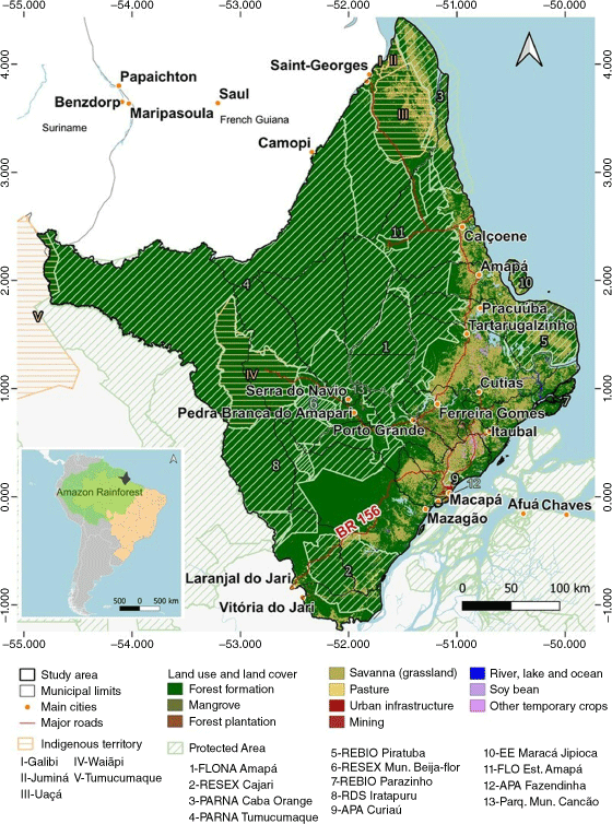
Our study considers a spatial approach of geopolitical boundaries (Amapá state) because this is the level of decision making for management of the territory. Amapá state is limited to the south and north by wide rivers (Amazonas and Oyapock rivers), to the east by an estuarine and oceanic coastal area (Amazonas estuary and the Atlantic Ocean) and to the west by pristine rainforest. The Amapá area extends over 142 470 km2, of which approximately 73% was destined for the maintenance of traditional people and conservation, including five indigenous territories and thirteen protected areas (PA), managed by the government (from different jurisdictions) and established under different categories (Brazilian legislation, Law 9985/2000) (Fig. 1).
|
Overview, assumptions and sources of uncertainty
First, we predicted fire probability in the recent period (hereafter ‘baseline’) aiming to reproduce present-day fire distributions. The sample window extended beyond the Amapá boundary, encompassing regions of the lower part and the mouth (estuary) of the Amazon River, which are influenced by flooding and urban centres (e.g. Belém and Santarém, located in Pará state), and including French Guiana and most of Suriname. Accounting for the validity of the baseline model, we projected future models to estimate changes in fire probabilities in the next decades (2020–2040) and at the end of this century (2080–2100), considering two contrasting scenarios of climate warming. The future fire models were fitted altering only the climate layers, assuming that all other predictor variables would remain stable, maintaining conditions similar to those found at the current time. This was a deliberate choice, as temperature and precipitation variables consistently surface as major controls of fire (Krawchuk et al. 2009). However, our simplifying assumption is deliberately biased, underestimating fire propensity, as we do not consider future changes in variables related to fuel dynamics, vegetation shifts and ignition rates. We emphasise that we do not incorporate dynamic vegetation and fuel models into our fire models, as it is still not well understood how vegetation systems will respond to climate change (McDowell et al. 2013; Williams and Abatzoglou 2016).
Fire occurrence data
Fire occurrences were obtained for the period between 2000 and 2020 from the Fire Information for Resource Management System (FIRMS) dataset gathered from Google Earth Engine (GEE), which uses the standard MODIS (Moderate Resolution Imaging Spectroradiometer) MOD14/MYD14 Fire and Thermal Anomalies product (MODIS 2021). These data were filtered to select only the MODIS hotspots with median values for confidence levels equal to 100% because it would not be desirable to have false positives. Using this criterion, we identified a total of 2253 fire occurrences, of which 236 were registered in the state of Amapá.
Environmental and human predictors
Land-use and land cover
Land use and land cover information (Fig. 1) is a key variable that can provide an assessment of landscape fire patterns. These data were used as a categorical layer and gave rise to continuous layers using the Euclidean distance to represent the influences of distinct floristically structured vegetation and human activities.
The vegetation was characterised considering three aspects: flammability, assessed through the Normalized Difference Vegetation Index (NDVI) to measure the live fuel moisture content (Chuvieco 2003); fire probability, linked to the amount of fuel (Krawchuk et al. 2009) and represented as biomass density; and fuel type, through information on two vegetation cover classes (forest and savanna).
Human influence
Aiming to assess the human footprint related to ignition patterns, we retrieved information on the spatial distribution of available road infrastructure (Ministério dos Transportes 2019), protected areas (Ministério do Meio Ambiente 2020), land use types and waterways (Project MapBiomas 2019). These factors are frequently associated with human ignitions (Flannigan et al. 2009; Bowman et al. 2011; Archibald et al. 2013; Chuvieco et al. 2014). The data collected gave rise to five raster files of human influence sources, in which each cell represented a distance value (Euclidean method) from the closest road, water, farming activity, urban land use and protected areas.
Elevation and climatic variables
Bioclimatic variables (historical and future climate) and elevation data (Shuttle Radar Topography Mission (SRTM)) are available in the WorldClim version 2.1 database (downloaded from http://worldclim.org). The baseline model was based on average climatic data for 1971–2000 (Fick and Hijmans 2017). The future fire models were based on average climatic data projected from CNRM-CM6-1, the fully coupled atmosphere–ocean general circulation model (GCM) of the sixth generation jointly developed by Centre National de Recherches Météorologiques (CNRM) and Cerfacs for the sixth phase of the Coupled Model Intercomparison Project 6 (CMIP6) (Voldoire et al. 2019). In the present work, we considered the CNRM-CM6-1 model because it performs reasonably well in humid regions (Parsons 2020; Yazdandoost et al. 2021). The future fire models for the early (2021–2040) and end of (2071–2100) the 21st century were based on two scenarios that combine socioeconomic and technological development (shared socioeconomic pathways, SSPs) (O’Neill et al. 2013; Gidden et al. 2019), an optimistic scenario (SSP 1-2.6, a low emission scenarios, where temperatures will stabilise at approximately 1.8°C, relative to 1850–1900, by the end of the century) and a pessimistic scenario (SSP 5-8.5, which assumes an increase in warming of nearly 4.4°C by 2100 over preindustrial levels and crossing a 2°C increase in 2050).
Variable selection
First, all layers of environmental and human predictors (Table 1) were resampled to the same pixel size as the climatic data (2.5 arc min a side or approximately 5 km at the equator) using the nearest-neighbour process. Then, we analysed the variable set for the baseline model to select the most important uncorrelated predictors and lead parsimonious and interpretable models (Merow et al. 2013). Two procedures were used to reduce multicollinearity between variables, as per Mohammadi et al. (2021). We started with an implementation of an optimised selection of 29 variables (continuous variables), processed in the R program (R Core Team 2020), based on the sample size corrected for the highest area under the curve (AUC) of the receiver operating characteristic (ROC) and the lowest Akaike information criterion (AIC). Variables were removed by setting a contribution threshold of 1%, regularisation multiplier of 1–5 with increments of 0.5 and Pearson’s correlation coefficient >|0.7|. Then, to overcome multicollinearity between the selected variables, we calculated the variance inflation factor (VIF) using the R package usdm (Naimi et al. 2014) and excluded variables with VIF >5.

|
Overall, seven variables were selected, of which two were associated with human factors (‘Distance to roads’ and ‘Distance to farming’) and one was associated with topography (‘Elevation’); there were four climatic layers for 1970–2000 (one for temperature and three for precipitation): temperature annual range, annual precipitation, precipitation seasonality and precipitation of the warmest quarter. Additionally, we included the categorical variable related to land use land cover (LULC) types, resulting in a final dataset that converged to a total of eight variables considered in the construction of the ‘baseline’ and ‘future’ fire probability models.
MaxEnt modelling of fire occurrences
We assessed the fire potential in different regions by treating fire as an entity analogous to an ecological species and applying ecological niche theory, specifically ecological niche modelling, via the maximum entropy (MaxEnt) method. We chose the MaxEnt method because it is a presence-only machine learning algorithm that iteratively contrasts multiple predictor values at occurrence locations (i.e. ignition points) with those of random locations across the study area (Elith et al. 2010), resulting in models that are able to describe complex relationships (Parisien et al. 2012). The conceptual approach and MaxEnt method have been recommended for fire studies carried out in different parts of the world, with different objectives (Parisien et al. 2012; Renard et al. 2012; Bar Massada et al. 2013; Arpaci et al. 2014; De Angelis et al. 2015; Duane et al. 2015; Davis et al. 2017; Li et al. 2017; Adab et al. 2018; Fonseca et al. 2019; Molina et al. 2019; Xiong et al. 2020; Arenas-Castro and Sillero 2021). Here, the analyses were performed using the open-source ‘MaxEnt’ software version 3.4.4. (Phillips et al. 2020).
The algorithm was run with default settings (more details can be found in Phillips et al. 2006, 2017; Phillips and Dudík 2008), except that the ‘Maximum iterations’ value was set to 5000, the number of replications was set to 1000 and the ‘Random seed’ option was selected. We fitted baseline and future climatic models to our data using the subsample replicate run type, with 70% of the fire occurrence cells used as training data and 30% as test data. Therefore, 30% of the test data and a set of 10 000 random background cells were used to validate the model.
Model evaluation and variables’ contributions
Model performances were evaluated with the widely used AUC statistic (Fielding and Bell 1997), which measures the ability of the model prediction to discriminate fire presence from background points. Although AUC has been criticised (Lobo et al. 2008), it is the standard method to assess prediction accuracy because of its threshold independence (Phillips et al. 2006; Franklin and Miller 2009) and the simplicity of interpreting its results (Bar Massada et al. 2013).
The relative importance of the predictor variables in the model was tested using two approaches provided by MaxEnt: percentage contribution and jack-knife metrics (leave-one-out cross-validation). The percentage contribution is determined by a heuristic approach in which values represent the cumulative gain (fit) to the model provided by the corresponding variable (Phillips 2017). The jack-knife approach was used to measure how much unique information each variable provides in explaining the fire distribution as each variable is excluded one at a time when running the model with the remaining variables (Baldwin 2009).
Spatial fire distribution of the baseline model and change analysis
The output probability of fire was given by the complementary log-log transformation (cloglog format), which gives an estimated value between 0 and 1, with higher values demonstrating more fire-prone conditions. To carry out zonal analyses, we classified the pixels of the models into five levels of suitability: very low (0.00 < x ≤ 0.10 → 1), low (0.10 < x ≤ 0.30 → 2), moderate (0.30 < x ≤ 0.50 → 3), high (0.50 < x ≤ 0.75 → 4) and very high (0.75 < x ≤ 1.00 → 5). For the baseline model, we quantified the area occupied by each habitat suitability class for fire occurrence in relation to its land use and land cover.
Changes in fire probability in relation to future climate shifts were detected through two distinct methods. The first recognised the differences between the modelled predictions after their conversions into binary maps, applying the 10th percentile training presence logistic threshold to define suitable and unsuitable raster cells. Overlay analysis was conducted between the baseline and each predicted future model, resulting in four expected change maps, where projected decreases in fire propensity were indicated as retreats and increases as invasions. These results allowed us to identify potential ‘hotspots of change’ for different scenarios and temporal scales. The second method comprised comparative analyses between the models in relation to the coverage by different fire classes in different scenarios and a classification agreement (pixel-by-pixel correspondence) analysis computed using the R packages Greenbrown (Forkel and Wutzler 2015) and DiffeR (Pontius and Santacruz 2015), allowing the generation of shift maps (Supplementary information). Additionally, concerns about how fire probabilities would change in areas currently occupied by forests and savannas under different emission scenarios were analysed using summary statistics in the form of percentage loss or gain in different fire suitability classes.
Results
Performance of the modelling approaches
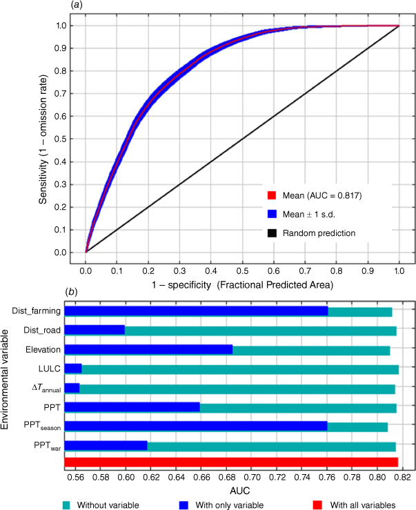
The AUC average test value for the baseline model developed for fire occurrence was 0.817 ± 0.008 (Fig. 2). The AUC values for the 2030s optimistic, 2030s pessimistic, 2090s optimistic and 2090s pessimistic models obtained from the validation phase processing exhibited respective values of 0.803, 0.816, 0.817 and 0.803. These results, according to the thresholds proposed by Vilar et al. (2016) in research on fire modelling, indicate that the predictive performance of the MaxEnt models was excellent in terms of goodness-of-fit with the training datasets.
|
Variable importance
Regarding the relative contributions of the environmental variables, ‘Distance to Farming’, ‘Precipitation Seasonality’ and ‘Elevation’ were the strongest predictors of fire distribution, with contributions of 55.4, 16.8 and 10.4%, respectively (Supplementary Table S1). The AUC values calculated by the jack-knife metrics supported this overview and revealed that the individual importance of these three variables was high (Fig. 2).
The response curves of the main factors affecting the possibility of fire occurrence highlighted some details regarding the patterns of distribution (Supplementary Fig. S1). Fire occurrence was negatively related to ‘Distance to Farming’, demonstrating that fires are more likely to occur closer to agriculture, pasture and silviculture. Water availability, especially precipitation seasonality, emerged as the main climatic driver of fire probability. The probability of fire occurrence displayed a complex relationship with elevation, with fire occurrence exhibiting a peak at approximately 100 m and then increasing again from approximately 400 m above sea level. This result demonstrates that the occurrence of fire is more frequent in the Amazon lowlands and plain regions, but our sample window also captured fire occurrences in Guyana’s Shield region.
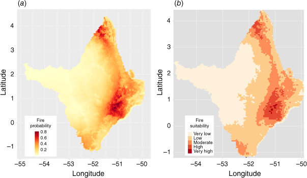
Baseline model of fire probability
The baseline model captured a complex spatial pattern of fire activity (Fig. 3). In general, areas where fire was not observed in the fire dataset had ‘very low’ and ‘low’ predicted fire probabilities (probability ≤ 0.3). These classes occupied approximately 80.6% (114 925 km²) of the territory of the state of Amapá, and the current coverage of these areas is represented, almost entirely, by forest vegetation (81.3%) (Fig. 4). In relation to areas of high fire probability (≥0.5 probability), we observed a strong coincidence with the distribution of savanna vegetation and with forests located close to areas currently used for agriculture and pasture.
|

|
Spatially, we observed that the region classified as ‘very low’ suitability was located in western Amapá state, a relatively isolated region with a higher relief, including the pristine rainforest ranges of Tumucumaque National Park, the largest protected area of tropical forest in the world. The model predicted ‘low’ fire probabilities in forests in the most central region of the state, in wetlands, floodplain forests and mangroves. The class of ‘moderate’ fire suitability was found mainly in areas occupied by savannas, savanna–forest transition areas and along the highway that connects the state of Amapá from north to south (Highway BR156).
The highest probability classes (8528 km2) were concentrated in two regions, one in the central eastern part of Amapá state and the other located close to the French Guiana border. In the most central area, ‘very high’ probabilities (≥0.75 probability) were linked mainly to agricultural activities, including forestry for the national and international markets. Relative to the region located north of Amapá, extensive cattle raising seemed to be a major driver of fire occurrence, but influences from subsistence or small-scale agriculture practiced by indigenous communities also existed.
Projected future fire probabilities
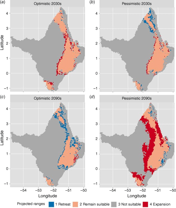
The future fire distributions projected (Supplementary Fig. S2) showed that large areas of Amapá state are expected to experience small near-term changes in fire probabilities. Then, in the coming decades, the fire propensity classes predicted in the present seem to hold for both the optimistic and pessimistic scenarios. These results are demonstrated by areas where fire propensity remained unchanged in the shift maps (Fig. 5) and also by high agreement between the baseline and the 2030s models (Supplementary Fig. S3). However, predicted changes deviated significantly more from current conditions over time and under a higher emission scenario.
|
We observed high similarity between the optimistic and pessimistic emission scenarios projected for the near future (91% agreement). However, it is important to note that under a high emission scenario (pessimistic 2030s), some areas in northern Amapá state showed projections of decreasing fire probability (Fig. 5). This seems to be related to conditions of lower seasonal precipitation, because the average annual temperature was predicted with values higher than the optimistic scenario and there was a forecast reduction in annual precipitation (5.5% less than current conditions).
Toward the end of the 21st century, the model for the low emission scenario showed relative similarity to the baseline (87% agreement) and high dissimilarity with respect to the pessimistic scenario (49.2% agreement). The pessimistic model, in turn, showed high dissimilarity to the baseline model (53%), mainly due to the increase in area occupied by moderate and high suitability classes for fire occurrence (Fig. 6).

|
Changing disturbance regimes in forest areas and savannas
In the near future, an optimistic low emission scenario would result in little change to fire probabilities in areas currently occupied by savannas, but some forest areas would become more susceptible to fire. In spatial terms, expansion of fires in forest areas would occur in the central part of the state in both pessimistic and optimistic scenarios (Fig. 5). On the other hand, if the pessimistic scenario prevails in the coming decades, forest and savanna vegetation located in the north of the state of Amapá will be less threatened by fire risk.
Toward the end of the 21st century, the pessimistic scenario for high emissions indicates the expansion of areas of greater suitability for fire occurrence in forest or savanna areas compared with the baseline. This finding is evidenced by the increase in the proportion of moderate and high classes and decrease in the proportion of classes with lower fire probability for both types of vegetation (Fig. 7).

|
Comparing the optimistic and pessimistic scenarios projected for 2090s, we found that the pessimistic scenario showed increases in high suitability fire classes of ~9.6% for forests and 15.8% for savannas.
Discussion
Fire distribution under current conditions
Our spatial fire distribution modelling emphasised that fire, climate conditions and farming are inextricably linked. Regarding climate constraints that influence fire distribution, we identified three dominant variables: precipitation seasonality, annual precipitation and annual temperature range. These variables are associated with biomass drying and climatic seasonality, processes that characterise the occurrence of savannas and result in their greater propensity for fire. However, a significant proportion of the areas occupied by Amazon savannas had low fire probability, which suggests that in these areas, flooded soils represent the main restrictive factor for the occurrence of ignition, as well as for the growth of trees. Flooding processes occur in Amapá (Santos 2016; Anthony et al. 2021) due to: the overflow of water in a river or lake onto neighbouring lands (fluvial flood); the accumulation of rainwater (pluvial flood); and the inundation of land along the coast by seawater (coastal flood).
We also found evidence that human-induced fire events are the main driver of ignition in the northeastern Amazon region, highlighting a strong relationship between fires and agricultural systems, which can be intensified by the presence of roads. This result is similar to that reported by Archibald et al. (2013), whose research on global pyrome identification resulted in the classification of much of the state of Amapá into a region where human activities, particularly deforestation and agriculture, are a major force that disrupts the fire system. The use of fire for land management is ‘embedded in the culture and economic logic of millions of rural Amazonians’, as this primary technique approach facilitates land clearing, improves soil fertilisation in slash-and-burn agriculture and favours cattle pasture (extensive system), either in implementation or during maintenance (Nepstad et al. 2001).
Our fire model captured the spatial concentrations of very highly fire-prone areas, which are related to altered fire regimes, mainly in landscapes originally covered by savanna vegetation. There are some reasons for crop, livestock and forestry activities occurring in preference in savannas rather than in forests in the northeastern Amazon: lower economic costs, fewer environmental restrictions and greater access to road networks. These results reinforce the finding that in Amapá, savannas are highly threatened ecosystems that have received very little attention, with gaps in scientific knowledge and almost no protection, compared with the forested parts of the state (Mustin et al. 2017).
For savanna areas, the sustainable use of fire for managing cattle ranching and protected areas is recommended, but the regimes must be fitted to local specific features (Pivello 2011; Borges et al. 2016; Mustin et al. 2017; Pivello et al. 2021). In addition, environmental, economic and social benefits can be generated if aspects of fire susceptibility are considered in the analyses to define zoning regulations by legal instruments, ordering the suitable use of the land and fire regime prescriptions. Furthermore, considering the influence of farming on fire occurrence outbreaks, strategies to adjust agricultural practices should be considered, such as training farmers to improve the use of fire and increase safety measures (Adab et al. 2018).
Regarding fire ignitions influenced by road networks, we observed a greater vulnerability of roadside vegetation, especially in areas covered by forest along the BR156 highway. According to Pivello (2011), roads facilitate logging activities, and the extraction of large trees opens the forest canopy, decreases the local moisture, and strongly increases forest susceptibility to wildfires. For regions near the BR156 highway, we suggest fire prevention and mitigation strategies, prioritising the allocation of public resources and support systems to combat illegal burning. We also note the strategies suggested by Pivello (2011), which include the development of policies to stimulate fire-free practices and small-scale agricultural projects. We recognise the importance of creating mechanisms that support and favour the continued development of markets and incentives for small-scale producers for sustainable development (Mustin et al. 2017).
Fire patterns and climate-related changes
For the next few decades, our modelled potential fire distributions were very similar to those for the present time, regardless of the emission scenario analysed. In line with these results, Krawchuk et al. (2009), in a previous study on global pyrogeography, demonstrated that for a medium–high emission scenario, no invasions or fire retreats were found for the same region. However, this would only be achieved under sustainable land use projections. According to Fonseca et al. (2019), when land conversion predictions (fragmented landscapes) are coupled with intermediate emission scenarios, the changes can be significant, with an increase in the probability of fire occurrence in the intermediate future (2041–2070).
Regarding changes in fire niches in the late 21st century, the patterns of expansion and contraction demonstrate more pronouncedly divergent situations when comparing the optimistic and pessimistic scenarios (Fig. 5). In this sense, our results confirm our hypothesis, as the large expansion of fire-prone areas was projected to occur under a scenario of higher emissions independently of land cover change. Consequently, continued emissions of greenhouse gases would increase biodiversity loss, put the water cycle at risk and negatively affect the ecosystem services provided to local people.
These threats may be even greater than projected in this study and fire propensity may expand to an even larger area than projected here, beause we do not associate predictions of land use and land cover changes. Regarding human influence, although the state of Amapá has extensive areas with restrictions for land use conversion, it is likely that fast changes in land cover around protected areas could lead to an increase in the potential for future fires. The increase in the occurrence of fires can also lead to conversions in vegetation types, as observed by Brando et al. (2014) in southeastern Amazonia, where the synergistic effect between fire and recent severe droughts has led to the conversion of forest species to flammable grass species near forest edges. Therefore, the magnitude of fire disturbances may be amplified by positive feedback loops between fires and increases in forest flammability (Cochrane and Schulze 1999; Cochrane et al. 1999; Nepstad et al. 2001; Hoffmann 2003; Balch et al. 2015). Grass–fire cycles, for example, are important for many forest frontiers where fires interact positively with exotic grass invasion (D’Antonio and Vitousek 1992; Veldman and Putz 2011; Silvério et al. 2013), with potentially disastrous consequences considering synergies between deforestation and climate change (Malhi et al. 2009; Silvestrini et al. 2011; Le Page et al. 2017; Xu et al. 2020).
Maintaining or increasing current patterns of fire occurrences in the northeast region of the Amazon could change the role of the world’s largest rainforest in balancing the global carbon budget. According to evidence found by Gatti et al. (2021), the eastern region of the Amazon can already be considered as a source of carbon emissions. Therefore, in this study, we provide information that can help decision makers to outline fire prevention, management and suppression strategies, minimising the risks of degradation of Amazonian ecosystems.
Limitations
Our projections are biased in terms of the algorithm selected for the modelling itself and the set of future climate data obtained from a single GCM. Therefore, without a doubt, there are limitations in our results that mainly stem from the lack of accuracy or precision in the climate data restricted by the predictions of the CNRM-CM6-1. Furthermore, our results should be interpreted with caution for the late 21st century, because we do not associate predictions of land use and land cover changes, shifts in vegetation resulting from climate change and fires, and fuel dynamics. Therefore, our simulations should be interpreted as a motivation for future efforts, which can advance contributions through more complex models.
Conclusion
In recent years, the synergy between socioeconomic and environmental factors has resulted in a greater spatial concentration of regions with a high probability of fire occurrence in the northeast Amazon. Farming activities were identified as the main driver for the occurrence of ignitions and the highest fire activity was observed in Amazonian savannas and savanna–forest transition. As savannas are fire-dependent, sustainable use of fire is recommended, but forest fires are likely to be a cause for concern in the face of climate change impacts. For the coming decades, our models suggest that wildfire potential is projected to expand into some currently pristine and highly humid forests, regardless of the emission scenario analysed. Regarding long-term scales, the conditions predicted under the high emission scenario (SSP 5-8.5) show a significant increase in fire propensity in areas previously unaffected by fire. Consequently, this scenario would negatively affect people, biodiversity and ecosystems on a local scale, as well as resulting in global ecological threats. Conversely, the optimistic emissions scenario (SSP 1-2.6) shows the importance of limiting global warming to 1.8°C by the end of the century to minimise the environmental and social costs associated with wildfires in the Amazon. Our predictions of future trends in fire activity are inherently uncertain and can be considered conservative, because our model does not incorporate feedbacks between vegetation and climate, or land use and land cover changes. However, our results represent a major contribution to addressing regional and global challenges posed to human well-being and biodiversity. Therefore, the present research can allow stakeholders to identify where propensity for future fires might (or not) increase in order to apply efficient short and long-term action planning.
Supplementary material
Supplementary material is available online.
Data availability
Climate data (historic and future) are available from WorldClim (www.worldclim.org). The CMIP6 model data produced by CNRM (Centre National de Recherches Meteorologiques, Toulouse 31057, France), CERFACS (Centre Europeen de Recherche et de Formation Avancee en Calcul Scientifique, Toulouse 31057, France) (CNRM-CERFACS) is licensed under a Creative Commons Attribution–Non Commercial–ShareAlike 4.0 International Licence (CC BY-NC-SA 4.0). Fire occurrence data and from other environmental and human layers were collected from databases with full and open sharing.
Conflicts of interest
The authors declare no conflicts of interest.
Declaration of funding
This research did not receive any specific funding.
Acknowledgements
This work arose from a doctoral thesis carried out by MMMS in the postgraduate program in Ecology at the Federal University of Bahia – UFBA (Brazil), guided by EMN and RNV. All authors contributed ideas and text to the final manuscript. Support for MMMS was provided by the University of the State of Amapá - UEAP (teaching activities licence for full dedication to research, 2020–2021).
References
Adab H, Atabati A, Oliveira S, Moghaddam Gheshlagh A (2018) Assessing fire hazard potential and its main drivers in Mazandaran province, Iran: a data-driven approach. Environmental Monitoring and Assessment 190, 670| Assessing fire hazard potential and its main drivers in Mazandaran province, Iran: a data-driven approach.Crossref | GoogleScholarGoogle Scholar |
Alencar AA, Brando PM, Asner GP, Putz FE (2015) Landscape fragmentation, severe drought, and the new Amazon forest fire regime. Ecological Applications 25, 1493–1505.
| Landscape fragmentation, severe drought, and the new Amazon forest fire regime.Crossref | GoogleScholarGoogle Scholar |
Anthony EJ, Brondizio ES, dos Santos VF, Gardel A, Besset M (2021) Sustainable Management, Conservation, and Restoration of the Amazon River Delta and Amazon-Influenced Guianas Coast: A Review. Water 13, 1371
| Sustainable Management, Conservation, and Restoration of the Amazon River Delta and Amazon-Influenced Guianas Coast: A Review.Crossref | GoogleScholarGoogle Scholar |
Aragão LEOC, Malhi Y, Roman-Cuesta RM, Saatchi S, Anderson LO, Shimabukuro YE (2007) Spatial patterns and fire response of recent Amazonian droughts. Geophysical Research Letters 34, L07701
| Spatial patterns and fire response of recent Amazonian droughts.Crossref | GoogleScholarGoogle Scholar |
Aragão LEOC, Malhi Y, Barbier N, Lima A, Shimabukuro Y, Anderson L, Saatchi S (2008) Interactions between rainfall, deforestation and fires during recent years in the Brazilian Amazonia. Philosophical Transactions of the Royal Society B: Biological Sciences 363, 1779–1785.
| Interactions between rainfall, deforestation and fires during recent years in the Brazilian Amazonia.Crossref | GoogleScholarGoogle Scholar |
Archibald S, Lehmann CER, Gómez-Dans JL, Bradstock RA (2013) Defining pyromes and global syndromes of fire regimes. Proceedings of the National Academy of Sciences 110, 6442–6447.
| Defining pyromes and global syndromes of fire regimes.Crossref | GoogleScholarGoogle Scholar |
Arenas-Castro S, Sillero N (2021) Cross-scale monitoring of habitat suitability changes using satellite time series and ecological niche models. Science of The Total Environment 784, 147172
| Cross-scale monitoring of habitat suitability changes using satellite time series and ecological niche models.Crossref | GoogleScholarGoogle Scholar |
Arpaci A, Malowerschnig B, Sass O, Vacik H (2014) Using multivariate data mining techniques for estimating fire susceptibility of Tyrolean forests. Applied Geography 53, 258–270.
| Using multivariate data mining techniques for estimating fire susceptibility of Tyrolean forests.Crossref | GoogleScholarGoogle Scholar |
Baccini A, Goetz SJ, Walker WS, Laporte NT, Sun M, Sulla-Menashe D, et al. (2012) Estimated carbon dioxide emissions from tropical deforestation improved by carbon-density maps. Nature Climate Change 2, 182–185.
| Estimated carbon dioxide emissions from tropical deforestation improved by carbon-density maps.Crossref | GoogleScholarGoogle Scholar |
Balch JK, Brando PM, Nepstad DC, Coe MT, Silvério D, Massad TJ, Davidson EA, Lefebvre P, Oliveira-Santos C, Rocha W, Cury RTS, Parsons A, Carvalho KS (2015) The Susceptibility of Southeastern Amazon Forests to Fire: Insights from a Large-Scale Burn Experiment. BioScience 65, 893–905.
| The Susceptibility of Southeastern Amazon Forests to Fire: Insights from a Large-Scale Burn Experiment.Crossref | GoogleScholarGoogle Scholar |
Baldwin R (2009) Use of Maximum Entropy Modeling in Wildlife Research Entropy 11, 854–866.
| Use of Maximum Entropy Modeling in Wildlife ResearchCrossref | GoogleScholarGoogle Scholar |
Bar Massada A, Syphard AD, Stewart SI, Radeloff VC (2013) Wildfire ignition-distribution modelling: a comparative study in the Huron–Manistee National Forest, Michigan, USA. International Journal of Wildland Fire 22, 174–183.
| Wildfire ignition-distribution modelling: a comparative study in the Huron–Manistee National Forest, Michigan, USA.Crossref | GoogleScholarGoogle Scholar |
Barbosa MLF, Delgado RC, Teodoro PE, Pereira MG, Correia TP, de Mendonça BAF, Ávila Rodrigues R (2019) Occurrence of fire foci under different land uses in the State of Amazonas during the 2005 drought. Environment, Development and Sustainability 21, 2707–2720.
| Occurrence of fire foci under different land uses in the State of Amazonas during the 2005 drought.Crossref | GoogleScholarGoogle Scholar |
Borges SL, Eloy L, Schmidt IB, Barradas ACS, Santos IAD (2016) Fire management in veredas (palm swamps): new perspectives on traditional farming systems in Jalapão, Brazil. Ambiente & Sociedade 19, 269–294.
| Fire management in veredas (palm swamps): new perspectives on traditional farming systems in Jalapão, Brazil.Crossref | GoogleScholarGoogle Scholar |
Bowman DMJS, Balch J, Artaxo P, Bond WJ, Cochrane MA, D’Antonio CM, DeFries R, Johnston FH, Keeley JE, Krawchuk MA, Kull CA, Mack M, Moritz MA, Pyne S, Roos CI, Scott AC, Sodhi NS, Swetnam TW (2011) The human dimension of fire regimes on earth. Journal of Biogeography 38, 2223–2236.
| The human dimension of fire regimes on earth.Crossref | GoogleScholarGoogle Scholar |
Brando PM, Balch JK, Nepstad DC, Morton DC, Putz FE, Coe MT, et al. (2014) Abrupt increases in Amazonian tree mortality due to drought-fire interactions. Proceedings of the National Academy of Sciences 111, 6347–6352.
| Abrupt increases in Amazonian tree mortality due to drought-fire interactions.Crossref | GoogleScholarGoogle Scholar |
Brando PM, Soares-Filho B, Rodrigues L, Assunção A, Morton D, Tuchschneider D, Fernandes ECM, Macedo MN, Oliveira U, Coe MT (2020) The gathering firestorm in southern Amazonia. Science Advances 6, eaay1632
| The gathering firestorm in southern Amazonia.Crossref | GoogleScholarGoogle Scholar |
Chuvieco E (2003) ‘Wildland Fire Danger Estimation and Mapping: the Role of Remote Sensing Data.’ (World Scientific Publishing Co.: River Edge, NJ)
Chuvieco E, Martínez S, Román MV, Hantson S, Pettinari ML (2014) Integration of ecological and socioeconomic factors to assess global vulnerability to wildfire. Global Ecology and Biogeography 23, 245–258.
| Integration of ecological and socioeconomic factors to assess global vulnerability to wildfire.Crossref | GoogleScholarGoogle Scholar |
Cochrane MA, Schulze MD (1999) Fire as a Recurrent Event in Tropical Forests of the Eastern Amazon: Effects on Forest Structure, Biomass, and Species Composition. Biotropica 31, 2–16.
| Fire as a Recurrent Event in Tropical Forests of the Eastern Amazon: Effects on Forest Structure, Biomass, and Species Composition.Crossref | GoogleScholarGoogle Scholar |
Cochrane MA, Alencar A, Schulze MD, Souza CM, Nepstad DC, Lefebvre P, Davidson EA (1999) Positive Feedbacks in the Fire Dynamic of Closed Canopy Tropical Forests. Science 284, 1832–1835.
| Positive Feedbacks in the Fire Dynamic of Closed Canopy Tropical Forests.Crossref | GoogleScholarGoogle Scholar |
Cox PM, Betts RA, Collins M, Harris PP, Huntingford C, Jones CD (2004) Amazonian forest dieback under climate-carbon cycle projections for the 21st Century. Theoretical and Applied Climatology 78, 137–156.
| Amazonian forest dieback under climate-carbon cycle projections for the 21st Century.Crossref | GoogleScholarGoogle Scholar |
D’Antonio CM, Vitousek PM (1992) Biological Invasions by Exotic Grasses, the Grass/Fire Cycle, and Global Change. Annual Review of Ecology and Systematics 23, 63–87.
| Biological Invasions by Exotic Grasses, the Grass/Fire Cycle, and Global Change.Crossref | GoogleScholarGoogle Scholar |
Davis R, Yang Z, Yost A, Belongie C, Cohen W (2017) The normal fire environment – Modeling environmental suitability for large forest wildfires using past, present, and future climate normals. Forest Ecology and Management 390, 173–186.
| The normal fire environment – Modeling environmental suitability for large forest wildfires using past, present, and future climate normals.Crossref | GoogleScholarGoogle Scholar |
De Angelis A, Ricotta C, Conedera M, Pezzatti GB (2015) Modelling the Meteorological Forest Fire Niche in Heterogeneous Pyrologic Conditions. PLoS One 10, e0116875
| Modelling the Meteorological Forest Fire Niche in Heterogeneous Pyrologic Conditions.Crossref | GoogleScholarGoogle Scholar |
de Carvalho WD, Mustin K (2017) The highly threatened and little known Amazonian savannahs. Nature Ecology & Evolution 1, 0100
| The highly threatened and little known Amazonian savannahs.Crossref | GoogleScholarGoogle Scholar |
Didan K (2015) MOD13A1 MODIS/Terra Vegetation Indices 16-Day L3 Global 500m SIN Grid V006 [Dataset]. NASA EOSDIS Land Processes DAAC.
Dong X, Li F, Lin Z, Harrison SP, Chen Y, Kug JS (2021) Climate influence on the 2019 fires in Amazonia. Science of The Total Environment 794, 148718
| Climate influence on the 2019 fires in Amazonia.Crossref | GoogleScholarGoogle Scholar |
Duane A, Piqué M, Castellnou M, Brotons L (2015) Predictive modelling of fire occurrences from different fire spread patterns in Mediterranean landscapes. International Journal of Wildland Fire 24, 407
| Predictive modelling of fire occurrences from different fire spread patterns in Mediterranean landscapes.Crossref | GoogleScholarGoogle Scholar |
Elith J, Phillips SJ, Hastie T, Dudík M, Chee YE, Yates CJ (2010) A statistical explanation of MaxEnt for ecologists. Diversity and Distributions 17, 43–57.
| A statistical explanation of MaxEnt for ecologists.Crossref | GoogleScholarGoogle Scholar |
Fanin T, van der Werf GR (2015) Relationships between burned area, forest cover loss, and land cover change in the Brazilian Amazon based on satellite data. Biogeosciences 12, 6033–6043.
| Relationships between burned area, forest cover loss, and land cover change in the Brazilian Amazon based on satellite data.Crossref | GoogleScholarGoogle Scholar |
Fearnside PM (1990) Fire in the tropical rain forests of the Amazon basin. In ‘Fire in the tropical biota: ecosystem processes and global challenges’. (Ed. JG Goldamer) pp. 106–116. (Springer-Verlag: Berlin, Germany)
Fick SE, Hijmans RJ (2017) WorldClim 2: new 1-km spatial resolution climate surfaces for global land areas. International Journal of Climatology 37, 4302–4315.
| WorldClim 2: new 1-km spatial resolution climate surfaces for global land areas.Crossref | GoogleScholarGoogle Scholar |
Fielding AH, Bell JF (1997) A review of methods for the assessment of prediction errors in conservation presence/absence models. Environmental Conservation 24, 38–49.
| A review of methods for the assessment of prediction errors in conservation presence/absence models.Crossref | GoogleScholarGoogle Scholar |
Flannigan MD, Krawchuk MA, de Groot WJ, Wotton BM, Gowman LM (2009) Implications of changing climate for global wildland fire. International Journal of Wildland Fire 18, 483–507.
| Implications of changing climate for global wildland fire.Crossref | GoogleScholarGoogle Scholar |
Fonseca MG, Alves LM, Aguiar APD, Arai E, Anderson LO, Rosan TM, Shimabukuro YE, de Aragão LEOC (2019) Effects of climate and land‐use change scenarios on fire probability during the 21st Century in the Brazilian Amazon. Global Change Biology 25, 2931–2946.
| Effects of climate and land‐use change scenarios on fire probability during the 21st Century in the Brazilian Amazon.Crossref | GoogleScholarGoogle Scholar |
Forkel M, Wutzler T (2015) greenbrown – land surface phenology and trend analysis. A package for the R software. Version 2.2, 2015-04-15. Available at http://greenbrown.r-forge.r-project.org/
Franklin J, Miller JA (2009) ‘Mapping Species Distributions: Spatial Inference and Prediction.’ (Cambridge University Press: Cambridge)
Gatti LV, Basso LS, Miller JB, Gloor M, Gatti Domingues L, Cassol HLG, et al. (2021) Amazonia as a carbon source linked to deforestation and climate change. Nature 595, 388–393.
| Amazonia as a carbon source linked to deforestation and climate change.Crossref | GoogleScholarGoogle Scholar |
Gidden MJ, Riahi K, Smith SJ, Fujimori S, Luderer G, Kriegler E, et al. (2019) Global emissions pathways under different socioeconomic scenarios for use in CMIP6: a dataset of harmonized emissions trajectories through the end of the century. Geoscientific Model Development 12, 1443–1475.
| Global emissions pathways under different socioeconomic scenarios for use in CMIP6: a dataset of harmonized emissions trajectories through the end of the century.Crossref | GoogleScholarGoogle Scholar |
Hardesty J, Myers R, Fulks W (2005) Fire, ecosystems, and people: a preliminary assessment of fire as a global conservation issue. The George Wright Forum 22, 78–87.
Hoffmann WA (2003) Regional feedbacks among fire, climate, and tropical deforestation. Journal of Geophysical Research 108, 4721
| Regional feedbacks among fire, climate, and tropical deforestation.Crossref | GoogleScholarGoogle Scholar |
Hoffmann WA, Geiger EL, Gotsch SG, Rossatto DR, Silva LCR, Lau OL, Haridasan M, Franco AC (2012) Ecological thresholds at the savanna–forest boundary: how plant traits, resources and fire govern the distribution of tropical biomes. Ecology Letters 15, 759–768.
| Ecological thresholds at the savanna–forest boundary: how plant traits, resources and fire govern the distribution of tropical biomes.Crossref | GoogleScholarGoogle Scholar |
Jimenez JC, Libonati R, Peres LF (2018) Droughts Over Amazonia in 2005, 2010, and 2015: A Cloud Cover Perspective. Frontiers in Earth Science 6, 227
| Droughts Over Amazonia in 2005, 2010, and 2015: A Cloud Cover Perspective.Crossref | GoogleScholarGoogle Scholar |
Krawchuk MA, Moritz MA, Parisien MA, Van Dorn J, Hayhoe K (2009) Global Pyrogeography: the Current and Future Distribution of Wildfire. PLoS One 4, e5102
| Global Pyrogeography: the Current and Future Distribution of Wildfire.Crossref | GoogleScholarGoogle Scholar |
Le Page Y, Morton D, Hartin C, Bond-Lamberty B, Pereira JMC, Hurtt G, Asrar G (2017) Synergy between land use and climate change increases future fire risk in Amazon forests. Earth System Dynamics 8, 1237–1246.
| Synergy between land use and climate change increases future fire risk in Amazon forests.Crossref | GoogleScholarGoogle Scholar |
Li S, Hughes AC, Su T, Anberrée JL, Oskolski AA, Sun M, et al. (2017) Fire dynamics under monsoonal climate in Yunnan, SW China: past, present and future. Palaeogeography, Palaeoclimatology, Palaeoecology 465, 168–176.
| Fire dynamics under monsoonal climate in Yunnan, SW China: past, present and future.Crossref | GoogleScholarGoogle Scholar |
Libonati R, Pereira JMC, Da Camara CC, Peres LF, Oom D, Rodrigues JA, Santos FLM, Trigo RM, Gouveia CMP, Machado-Silva F, Enrich-Prast A, Silva JMN (2021) Twenty-first century droughts have not increasingly exacerbated fire season severity in the Brazilian Amazon. Scientific Reports 11, 4400
| Twenty-first century droughts have not increasingly exacerbated fire season severity in the Brazilian Amazon.Crossref | GoogleScholarGoogle Scholar |
Lima A, Silva TSF, de Aragão LEOC, de Feitas RM, Adami M, Formaggio AR, Shimabukuro YE (2012) Land use and land cover changes determine the spatial relationship between fire and deforestation in the Brazilian Amazon. Applied Geography 34, 239–246.
| Land use and land cover changes determine the spatial relationship between fire and deforestation in the Brazilian Amazon.Crossref | GoogleScholarGoogle Scholar |
Lobo JM, Jiménez-Valverde A, Real R (2008) AUC: a misleading measure of the performance of predictive distribution models. Global Ecology and Biogeography 17, 145–151.
| AUC: a misleading measure of the performance of predictive distribution models.Crossref | GoogleScholarGoogle Scholar |
Malhi Y, Roberts JT, Betts RA, Killeen TJ, Li W, Nobre CA (2008) Climate Change, Deforestation, and the Fate of the Amazon. Science 319, 169–172.
| Climate Change, Deforestation, and the Fate of the Amazon.Crossref | GoogleScholarGoogle Scholar |
Malhi Y, Aragão LEOC, Galbraith D, Huntingford C, Fisher R, Zelazowski P, et al. (2009) Exploring the likelihood and mechanism of a climate-change-induced dieback of the Amazon rainforest. Proceedings of the National Academy of Sciences 106, 20610–20615.
| Exploring the likelihood and mechanism of a climate-change-induced dieback of the Amazon rainforest.Crossref | GoogleScholarGoogle Scholar |
Marengo JA, Nobre CA, Tomasella J, Cardoso MF, Oyama MD (2008) Hydro-climatic and ecological behaviour of the drought of Amazonia in 2005. Philosophical Transactions of the Royal Society B: Biological Sciences 363, 1773–1778.
| Hydro-climatic and ecological behaviour of the drought of Amazonia in 2005.Crossref | GoogleScholarGoogle Scholar |
McDowell NG, Fisher RA, Xu C, Domec JC, Hölttä T, Mackay DS, et al. (2013) Evaluating theories of drought-induced vegetation mortality using a multimodel-experiment framework. New Phytologist 200, 304–321.
| Evaluating theories of drought-induced vegetation mortality using a multimodel-experiment framework.Crossref | GoogleScholarGoogle Scholar |
Merow C, Smith MJ, Silander JA (2013) A practical guide to MaxEnt for modeling species’ distributions: what it does, and why inputs and settings matter. Ecography 36, 1058–1069.
| A practical guide to MaxEnt for modeling species’ distributions: what it does, and why inputs and settings matter.Crossref | GoogleScholarGoogle Scholar |
Ministério do Meio Ambiente (2020) Cadastro Nacional de Unidades de Conservação [Vector file from the Brazilian government database, in Portuguese]. Available at http://mapas.mma.gov.br/i3geo/datadownload.htm[accessed March 2020]
MODIS (2021) Collection 6 NRT Hotspot/Active Fire Detections MCD14DL. (NASA, EarthData)
| Crossref |
Mohammadi A, Almasieh K, Nayeri D, Ataei F, Khani A, López-Bao JV, et al. (2021) Identifying priority core habitats and corridors for effective conservation of brown bears in Iran. Scientific Reports 11, 1044
| Identifying priority core habitats and corridors for effective conservation of brown bears in Iran.Crossref | GoogleScholarGoogle Scholar |
Molina JR, Lora A, Prades C, Rodríguez y Silva F (2019) Roadside vegetation planning and conservation: New approach to prevent and mitigate wildfires based on fire ignition potential. Forest Ecology and Management 444, 163–173.
| Roadside vegetation planning and conservation: New approach to prevent and mitigate wildfires based on fire ignition potential.Crossref | GoogleScholarGoogle Scholar |
Moritz MA, Parisien MA, Batllori E, Krawchuk MA, Van Dorn J, Ganz DJ, Hayhoe K (2012) Climate change and disruptions to global fire activity. Ecosphere 3, 49
| Climate change and disruptions to global fire activity.Crossref | GoogleScholarGoogle Scholar |
Morton DC, Defries RS, Randerson JT, Giglio L, Schroeder W, Van Der Werf GR (2008) Agricultural intensification increases deforestation fire activity in Amazonia. Global Change Biology 14, 2262–2275.
| Agricultural intensification increases deforestation fire activity in Amazonia.Crossref | GoogleScholarGoogle Scholar |
Morton DC, Le Page Y, DeFries R, Collatz GJ, Hurtt GC (2013) Understorey fire frequency and the fate of burned forests in Southern Amazonia. Philosophical Transactions of the Royal Society B: Biological Sciences 368, 20120163
| Understorey fire frequency and the fate of burned forests in Southern Amazonia.Crossref | GoogleScholarGoogle Scholar |
Ministério dos Transportes (2019) Mapas e Bases dos Modos de Transportes. Base Georreferenciada - Rodovias [Vector file from the Brazilian government database, in Portuguese]. Available at https://www.gov.br/infraestrutura/pt-br [accessed March 2020]
Mustin K, Carvalho WD, Hilário RR, Costa-Neto SV, Silva C, Vasconcelos IM, Castro IJ, Eilers V, Kauano ÉE, Mendes-Junior RNG, Funi C, Fearnside PM, Silva JMC, Euler AMC, Toledo JJ (2017) Biodiversity, threats and conservation challenges in the Cerrado of Amapá, an Amazonian savanna. Nature Conservation 22, 107–127.
| Biodiversity, threats and conservation challenges in the Cerrado of Amapá, an Amazonian savanna.Crossref | GoogleScholarGoogle Scholar |
Naimi B, Hamm NAS, Groen TA, Skidmore AK, Toxopeus AG (2014) Where is positional uncertainty a problem for species distribution modelling? Ecography 37, 191–203.
| Where is positional uncertainty a problem for species distribution modelling?Crossref | GoogleScholarGoogle Scholar |
Nepstad D, Carvalho G, Barros AC, Alencar A, Capobianco JP, Bishop J, et al. (2001) Road paving, fire regime feedbacks, and the future of Amazon forests. Forest Ecology and Management 154, 395–407.
| Road paving, fire regime feedbacks, and the future of Amazon forests.Crossref | GoogleScholarGoogle Scholar |
Nepstad D, Lefebvre P, Lopes da Silva U, Tomasella J, Schlesinger P, Solórzano L, Moutinho P, Ray D, Guerreira Benito J (2004) Amazon drought and its implications for forest flammability and tree growth: a basin-wide analysis. Global Change Biology 10, 704–717.
| Amazon drought and its implications for forest flammability and tree growth: a basin-wide analysis.Crossref | GoogleScholarGoogle Scholar |
Nobre CA, Sellers PJ, Shukla J (1991) Amazonian Deforestation and Regional Climate Change. Journal of Climate 4, 957–988.
| Amazonian Deforestation and Regional Climate Change.Crossref | GoogleScholarGoogle Scholar |
O’Neill BC, Kriegler E, Riahi K, et al. (2013) A new scenario framework for climate change research: the concept of shared socioeconomic pathways. Climatic Change 122, 387–400.
| A new scenario framework for climate change research: the concept of shared socioeconomic pathways.Crossref | GoogleScholarGoogle Scholar |
Parisien M-A, Snetsinger S, Greenberg JA, Nelson CR, Schoennagel T, Dobrowski SZ, Moritz MA (2012) Spatial variability in wildfire probability across the western United States. International Journal of Wildland Fire 21, 313–327.
| Spatial variability in wildfire probability across the western United States.Crossref | GoogleScholarGoogle Scholar |
Parsons LA (2020) Implications of CMIP6 Projected Drying Trends for 21st Century Amazonian Drought Risk. Earth’s Future 8, e2020EF001608
| Implications of CMIP6 Projected Drying Trends for 21st Century Amazonian Drought Risk.Crossref | GoogleScholarGoogle Scholar |
Pausas JG, Keeley JE (2009) A Burning Story: The Role of Fire in the History of Life BioScience 59, 593–601.
| A Burning Story: The Role of Fire in the History of LifeCrossref | GoogleScholarGoogle Scholar |
Phillips SJ (2017) A Brief Tutorial on Maxent. Available at http://biodiversityinformatics.amnh.org/open_source/maxent/ [accessed March 2020]
Phillips SJ, Dudík M (2008) Modeling of species distributions with Maxent: new extensions and a comprehensive evaluation. Ecography 31, 161–175.
| Modeling of species distributions with Maxent: new extensions and a comprehensive evaluation.Crossref | GoogleScholarGoogle Scholar |
Phillips SJ, Anderson RP, Schapire RE (2006) Maximum entropy modeling of species geographic distributions. Ecological Modelling 190, 231–259.
| Maximum entropy modeling of species geographic distributions.Crossref | GoogleScholarGoogle Scholar |
Phillips SJ, Anderson RP, Dudík M, Schapire RE, Blair ME (2017) Opening the black box: an open-source release of Maxent. Ecography 40, 887–893.
| Opening the black box: an open-source release of Maxent.Crossref | GoogleScholarGoogle Scholar |
Phillips SJ, Anderson RP, Schapire RE (2020) Maxent software for modeling species niches and distributions (Version 3.4.4). Available at http://biodiversityinformatics.amnh.org/open_source/maxent/ [accessed March 2021]
Pires JM, Prance GT (1985) The vegetation types of the Brazilian Amazon. In ‘Amazonia: key environments’. (Eds Prance GT, Lovejoy TE) pp. 109–145. (Pergamon Press: New York)
Pivello VR (2011) The Use of Fire in the Cerrado and Amazonian Rainforests of Brazil: Past and Present. Fire Ecology 7, 24–39.
| The Use of Fire in the Cerrado and Amazonian Rainforests of Brazil: Past and Present.Crossref | GoogleScholarGoogle Scholar |
Pivello VR, Vieira I, Christianini AV, Ribeiro DB, da Silva Menezes L, Berlinck CN, et al. (2021) Understanding Brazil’s catastrophic fires: Causes, consequences and policy needed to prevent future tragedies. Perspectives in Ecology and Conservation 19, 233–255.
| Understanding Brazil’s catastrophic fires: Causes, consequences and policy needed to prevent future tragedies.Crossref | GoogleScholarGoogle Scholar |
Pontius RG, Santacruz A (2015) DiffeR: Metrics of Difference for Comparing Pairs of Maps (version 0.0-4). R. Available at https://cran.r-project.org/web/packages/diffeR
Prance GT (1996) Islands in Amazonia. Philosophical Transactions of the Royal Society of London Series B: Biological Sciences 351, 823–833.
| Islands in Amazonia.Crossref | GoogleScholarGoogle Scholar |
Project MapBiomas (2019) Collection 5 of Brazilian Land Cover & Use Map Series. Available at https://mapbiomas.org/ [accessed 2020]
R Core Team (2020) ‘R: A language and environment for statistical computing.’ (R Foundation for Statistical Computing: Vienna, Austria) Available at https://www.R-project.org/
Renard Q, Pélissier R, Ramesh BR, Kodandapani N (2012) Environmental susceptibility model for predicting forest fire occurrence in the Western Ghats of India. International Journal of Wildland Fire 21, 368–379.
| Environmental susceptibility model for predicting forest fire occurrence in the Western Ghats of India.Crossref | GoogleScholarGoogle Scholar |
Righi CA, de Alencastro Graça PML, Cerri CC, Feigl BJ, Fearnside PM (2009) Biomass burning in Brazil’s Amazonian “arc of deforestation”: Burning efficiency and charcoal formation in a fire after mechanized clearing at Feliz Natal, Mato Grosso. Forest Ecology and Management 258, 2535–2546.
| Biomass burning in Brazil’s Amazonian “arc of deforestation”: Burning efficiency and charcoal formation in a fire after mechanized clearing at Feliz Natal, Mato Grosso.Crossref | GoogleScholarGoogle Scholar |
Santos V (2016) Dinâmica de inundação em áreas úmidas costeiras: zona urbana de Macapá e Santana, costa amazônica, Amapá. PRACS: Revista Eletrônica de Humanidades do Curso de Ciências Sociais da UNIFAP 9, 121–144.
| Dinâmica de inundação em áreas úmidas costeiras: zona urbana de Macapá e Santana, costa amazônica, Amapá.Crossref | GoogleScholarGoogle Scholar | [In Portuguese]
Scholze M, Knorr W, Arnell NW, Prentice IC (2006) A climate-change risk analysis for world ecosystems. Proceedings of the National Academy of Sciences 103, 13116–13120.
| A climate-change risk analysis for world ecosystems.Crossref | GoogleScholarGoogle Scholar |
Silvério DV, Brando PM, Balch JK, Putz FE, Nepstad DC, Oliveira-Santos C, Bustamante MMC (2013) Testing the Amazon savannization hypothesis: fire effects on invasion of a neotropical forest by native cerrado and exotic pasture grasses. Philosophical Transactions of the Royal Society B: Biological Sciences 368, 20120427
| Testing the Amazon savannization hypothesis: fire effects on invasion of a neotropical forest by native cerrado and exotic pasture grasses.Crossref | GoogleScholarGoogle Scholar |
Silvestrini RA, Soares-Filho BS, Nepstad D, Coe M, Rodrigues H, Assunção R (2011) Simulating fire regimes in the Amazon in response to climate change and deforestation. Ecological Applications 21, 1573–1590.
| Simulating fire regimes in the Amazon in response to climate change and deforestation.Crossref | GoogleScholarGoogle Scholar |
Souza CM, Shimbo JZ, Rosa MR, Parente LL, Alencar AA, Rudorff BF, et al. (2020) Reconstructing three decades of land use and land cover changes in Brazilian biomes with Landsat archive and Earth Engine. Remote Sensing 12, 2735
| Reconstructing three decades of land use and land cover changes in Brazilian biomes with Landsat archive and Earth Engine.Crossref | GoogleScholarGoogle Scholar |
Uhl C, Buschbacher R (1985) A Disturbing Synergism Between Cattle Ranch Burning Practices and Selective Tree Harvesting in the Eastern Amazon. Biotropica 17, 265–268.
| A Disturbing Synergism Between Cattle Ranch Burning Practices and Selective Tree Harvesting in the Eastern Amazon.Crossref | GoogleScholarGoogle Scholar |
Uhl C, Kauffman JB (1990) Deforestation, fire susceptibility, and potential tree responses to fire in the eastern Amazon. Ecology 71, 437–449.
| Deforestation, fire susceptibility, and potential tree responses to fire in the eastern Amazon.Crossref | GoogleScholarGoogle Scholar |
Veldman JW, Putz FE (2011) Grass-dominated vegetation, not species-diverse natural savanna, replaces degraded tropical forests on the southern edge of the Amazon Basin. Biological Conservation 144, 1419–1429.
| Grass-dominated vegetation, not species-diverse natural savanna, replaces degraded tropical forests on the southern edge of the Amazon Basin.Crossref | GoogleScholarGoogle Scholar |
Vilar L, Gómez I, Martínez-Vega J, Echavarría P, Riaño D, Martín MP (2016) Multitemporal Modelling of Socio-Economic Wildfire Drivers in Central Spain between the 1980s and the 2000s: Comparing Generalized Linear Models to Machine Learning Algorithms. PLoS One 11, e0161344
| Multitemporal Modelling of Socio-Economic Wildfire Drivers in Central Spain between the 1980s and the 2000s: Comparing Generalized Linear Models to Machine Learning Algorithms.Crossref | GoogleScholarGoogle Scholar |
Voldoire A, Saint-Martin D, Sénési S, Decharme B, Alias A, Chevallier M, et al. (2019) Evaluation of CMIP6 DECK experiments with CNRM-CM6-1. Journal of Advances in Modeling Earth Systems 11, 2177–2213.
| Evaluation of CMIP6 DECK experiments with CNRM-CM6-1.Crossref | GoogleScholarGoogle Scholar |
Williams AP, Abatzoglou JT (2016) Recent Advances and Remaining Uncertainties in Resolving Past and Future Climate Effects on Global Fire Activity. Current Climate Change Reports 2, 1–14.
| Recent Advances and Remaining Uncertainties in Resolving Past and Future Climate Effects on Global Fire Activity.Crossref | GoogleScholarGoogle Scholar |
Xiong Q, Luo X, Liang P, Xiao Y, Xiao Q, Sun H, Pan K, Wang L, Li L, Pang X (2020) Fire from policy, human interventions, or biophysical factors? Temporal–spatial patterns of forest fire in southwestern China. Forest Ecology and Management 474, 118381
| Fire from policy, human interventions, or biophysical factors? Temporal–spatial patterns of forest fire in southwestern China.Crossref | GoogleScholarGoogle Scholar |
Xu X, Jia G, Zhang X, Riley WJ, Xue Y (2020) Climate regime shift and forest loss amplify fire in Amazonian forests. Global Change Biology 26, 5874–5885.
| Climate regime shift and forest loss amplify fire in Amazonian forests.Crossref | GoogleScholarGoogle Scholar |
Yazdandoost F, Moradian S, Izadi A, Aghakouchak A (2021) Evaluation of CMIP6 precipitation simulations across different climatic zones: Uncertainty and model intercomparison. Atmospheric Research 250, 105369
| Evaluation of CMIP6 precipitation simulations across different climatic zones: Uncertainty and model intercomparison.Crossref | GoogleScholarGoogle Scholar |
Zhao W, Zhao X, Zhou T, Wu D, Tang B, Wei H (2017) Climatic factors driving vegetation declines in the 2005 and 2010 Amazon droughts. PLoS One 12, e0175379
| Climatic factors driving vegetation declines in the 2005 and 2010 Amazon droughts.Crossref | GoogleScholarGoogle Scholar |