

Contemporary (1984–2020) fire history metrics for the conterminous United States and ecoregional differences by land ownership
Melanie K. Vanderhoof A * , Todd J. Hawbaker A , Casey Teske B , Joe Noble C and Jim Smith D
A US Geological Survey, Geoscience and Environmental Change Science Center, PO Box 25046, MS 980, Denver Federal Center, Denver, CO 80225, USA.
B US Fish and Wildlife Service, Branch of Fire Management, 3833 S Development Avenue, Boise, ID 83705, USA.
C Tall Timbers Research Station, 13093 Henry Beadel Dr, Tallahassee, FL 32312, USA.
D The Nature Conservancy, 1822 Swiss Oaks Street, Saint John’s, FL 32259, USA.
International Journal of Wildland Fire 31(12) 1167-1183 https://doi.org/10.1071/WF22044
Submitted: 5 April 2022 Accepted: 4 October 2022 Published: 2 November 2022
© 2022 The Author(s) (or their employer(s)). Published by CSIRO Publishing on behalf of IAWF. This is an open access article distributed under the Creative Commons Attribution-NonCommercial-NoDerivatives 4.0 International License (CC BY-NC-ND)
Abstract
Background: Remotely sensed burned area products are critical to support fire modelling, policy, and management but often require further processing before use.
Aim: We calculated fire history metrics from the Landsat Burned Area Product (1984–2020) across the conterminous U.S. (CONUS) including (1) fire frequency, (2) time since last burn (TSLB), (3) year of last burn, (4) longest fire-free interval, (5) average fire interval length, and (6) contemporary fire return interval (cFRI).
Methods: Metrics were summarised by ecoregion and land ownership, and related to historical and cheatgrass datasets to demonstrate further applications of the products.
Key results: The proportion burned ranged from 0.7% in the Northeast Mixed Woods to 74.1% in the Kansas Flint Hills. The Flint Hills and Temperate Prairies showed the highest burn frequency, while the Flint Hills and the Sierra Nevada and Klamath Mountains showed the shortest TSLB. Compared to private, public land had greater burned area (19 of 31 ecoregions) and shorter cFRI (25 of 31 ecoregions).
Conclusions: Contemporary fire history metrics can help characterise recent fire regimes across CONUS.
Implications: In regions with frequent fire, comparison of contemporary with target fire regimes or invasive species datasets enables the efficient incorporation of burned area data into decision-making.
Keywords: burned area, cheatgrass, fire frequency, fire regime, fire return interval, historic fire, land ownership, Landsat, wildland fire.
Introduction
The contemporary wildfire paradox in the United States is that past fire suppression has led to larger and more intense fires, even as we have less fire now than occurred historically. As evidence, pre-European settlement estimates of fire frequency were much greater than contemporary fire frequency (Frost 1998; Guyette et al. 2012; Parks et al. 2015; Blankenship et al. 2021); however, over the past 30–40 years, contemporary fire seasons have become longer (Jolly et al. 2015; Cattau et al. 2020), and fires more frequent and larger (Dennison et al. 2014; Yang et al. 2015; Donovan et al. 2017; Singleton et al. 2019). Given these trends, the United States’ Healthy Forest Restoration Act of 2003 and the National Fire Plan’s Cohesive Strategy established a national commitment to reduce fire hazards and restore fire where it has been excluded (Keane et al. 2007; Schoennagel et al. 2009). Prescribed fire programs, an important component of this national strategy, attempt to restore historical fire regimes while potentially reducing the risk of large, high-severity wildfires (Ryan et al. 2013; Schultz et al. 2019). Balancing the risk of fire to human health and safety with the necessary role that fire plays in many ecosystems (Braun de Torrez et al. 2018; Wiesner et al. 2019; Kramer et al. 2021) requires improved data on contemporary fire history metrics. However, while national, fire-related datasets such as burned area (Hawbaker et al. 2020a), wildfire risk to populations (Scott et al. 2020), and divergence from historical fire regime (Blankenship et al. 2021) datasets are all available, contemporary, national fire history metrics, or a series of measures that help characterise the contemporary fire regimes and time since last burn, have not yet been produced or analysed for the U.S. Fire history metrics can help us both retrospectively characterise fire regime patterns and changes, while also helping to guide and prioritise future policy, management, or strategic actions.
Fire and land management goals are often determined in the context of historical (i.e. pre-European settlement) fire frequency (Morgan et al. 2001; Blankenship et al. 2021). Historical fire frequency is predicted by ignition sources, as well as vegetation, fuel structure, weather, and climate (Frost 1998; Guyette et al. 2012) and can be reconstructed using fire scar chronologies, landform, historical vegetation records, charcoal, fire frequency indicator species, lightning ignition data, and remnant natural vegetation (Frost 1998; Morgan et al. 2001; Leys et al. 2017). For example, regional fire return intervals are typically derived from point-based, extended time series data, for example, tree or lake cores (e.g. McBride 1983; Mensing et al. 2006; Voelker et al. 2018). In the Great Plains, for instance, there is ample evidence that many grasslands persisted before European settlement through the widespread application of fire by Native Americans (Frost 1998; Leys et al. 2017).
Modern fire regimes are influenced by wildland fire suppression, the accepted U.S. policy for decades from the early 1900s (Busenberg 2004), which reduced wildland fire occurrence in both fire-prone forests (Keane et al. 2007) and grasslands (Twidwell et al. 2013; Perkins et al. 2019). Fire suppression, with land use change, invasive species, and fragmentation, continues to impact current fire activity by influencing vegetation condition, as well as fire ignition and spread (Ryan et al. 2013; Roos et al. 2020). Since the mid-1980s, large wildfires in the Great Plains have been increasing (Dennison et al. 2014; Balch et al. 2017; Donovan et al. 2017), and Southern California shows burning at higher frequencies than historically (Safford and Van de Water 2014). Much of central and northern California, in contrast, has still missed multiple fire cycles (Safford and Van de Water 2014; Parks et al. 2015), so that despite large, high-profile fires in recent years (Nauslar et al. 2018; Keeley and Syphard 2021), risk of large, high severity fires in this region continues (Roos et al. 2020; Hagmann et al. 2021).
The ability to implement national strategies to reduce fire hazards and restore historical fire regimes will depend at least in part on land ownership. Ownership influences the probability of fire ignition and spread, as well as fire-related incentives, priorities, and resources (Miller et al. 2012; Starrs et al. 2018). For example, agency-based and state-based differences in fire suppression strategies, wildland fire services, and prescribed fire programmes across the U.S. Federal Government has resulted in distinguishable fire regimes (Miller et al. 2012; Keeley et al. 2021). Further, federal land may show distinct conditions relative to non-federal lands (Joppa and Pfaff 2009; Ren et al. 2017), which can complicate comparisons of wildfire risk and total burned area (Andam et al. 2008; Starrs et al. 2018). While multiple U.S. agencies are tasked with reporting prescribed and wildland fires, most of these efforts are limited to public land (Short 2015; Nowell et al. 2018; Fusco et al. 2019), meaning that private land tends to have less complete fire data and burn histories, relative to public land. However, fire events and the ecosystem services they impact (e.g. nutrient cycling, water movement, and plant and wildlife habitat) move seamlessly across public–private boundaries. Thus, regional and national management of fire regimes require spatially consistent data over a long enough period to understand fire patterns and drivers (Short 2015; Nowell et al. 2018; Chuvieco et al. 2019; Fusco et al. 2019). For example, fire history metrics can inform management of fire-dependent species and ecosystems including invasive species, fire behaviour and emissions modelling, fire risk analysis, and prescribed fire planning (Liu et al. 2010; Addington et al. 2020; Gao et al. 2021). Remotely sensed burned area products provide critical information on fire locations and extent (Humber et al. 2019; Hawbaker et al. 2020a). While Landsat provides a longer record of burned area relative to products derived from other sensors such as Moderate Resolution Imaging Spectroradiometer (MODIS) (Chuvieco et al. 2019), all burned area products still require additional processing to summarise and facilitate their use in models and decision-making. Fire management across the U.S. will benefit from comprehensive, burned area data, delivered in a format to facilitate their direct use by diverse stakeholders. To date, however, contemporary, national fire history metrics have not been produced or analysed across the U.S. In this analysis we present contemporary fire history metrics, specifically, (1) fire frequency, (2) time since last burn, (3) year of last burn, (4) longest fire free interval, and (5) average fire interval length, derived from 37 years of the Landsat Burned Area (BA) Product (1984–2020) for the conterminous United States (CONUS). As our period of record (37 years) is short for many fire regimes across the country, particularly forested ecoregions with long fire-free intervals, we also calculate a contemporary fire return interval from the proportion of an area that burns each year (Higuera et al. 2021). With the resulting metrics, we addressed three research questions: (1) How do contemporary fire regimes differ by ecoregion and land ownership? (2) Are differences in metrics between public and private lands explained by inherent differences (e.g. topography and climate)? and (3) How can fire history metrics be combined with historical or complementary datasets, such as invasive species maps, to further facilitate decision-making?
Methods
Study area
Ecoregions were selected as the unit of analysis to summarise the spatial variability in each of the fire history metrics across the CONUS (Fig. 1). The U.S. Environmental Protection Agency’s level 3 ecoregions (n = 85; Omernik and Griffith 2014) were consolidated down to 31 ecoregions by combining ecoregions that belonged to the same level 2 ecoregion (n = 20; Omernik and Griffith 2014). The exception was where one or more level 3 ecoregions showed distinct fire activity or fire activity more similar to an adjacent ecoregion than its level 2 ecoregion. While the metrics were produced across all land cover classes, for this analysis, classes that could be considered either unburnable or highly managed were excluded, including open water, perennial ice/snow, developed medium and high intensity, barren, and cultivated crops, as defined by the National Land Cover Database (NLCD, ver. 2019; Homer et al. 2020) (Fig. 1). The 2019 developed land classes were assumed to represent the maximum extent over the period. Additional land may have been classified as water or agriculture during the 1984–2018 period; however, we assumed that applications of the metrics for decision-making would prioritise the current land cover distribution. As of 2019, landcover in the CONUS was dominated by shrub/scrub (22%), cultivated crops (16%), herbaceous (13%), evergreen forest (12%), and deciduous forest (9%). Climate patterns vary widely across the CONUS. Annual precipitation ranges from 239 mm year−1 in the warm desert ecoregion to 1812 mm year−1 in the Coast Range ecoregion. Maximum and minimum annual temperatures ranged from 11.0 to −2.3°C, respectively, in the Rocky Mountain ecoregion to 29.1 and 18.7°C, respectively, in the Everglades ecoregion (PRISM Climate Group 2021).

|
Landsat burned area products
The U.S. Geological Survey (USGS) Landsat BA Product (Hawbaker et al. 2020a, 2020b) was used to identify burned area across CONUS over a 37-year period (1984–2020, 30 m resolution). This product represents the longest temporal record of burned area extent, mapped with consistent effort across CONUS. Both wildfires and prescribed fires are mapped, but fire type is not distinguished. It is produced for each image with <80% cloud cover in the Landsat Thematic Mapper (TM), Enhanced Thematic Mapper (ETM+), and Operational Land Imager (OLI) Analysis Ready Datasets (ARD). Across CONUS, the scene product has a documented omission and commission error of 40% and 28%, respectively, validated from a Landsat reference dataset, and omission and commission error of 19% and 41%, respectively, validated from a set of classified high-resolution images (n = 286, Hawbaker et al. 2020a). Ecoregion-specific omission errors were calculated as the weighted average of the omission errors reported by land cover class (Hawbaker et al. 2020a), where land cover distribution was defined by the NLCD, ver. (2019). Sources of error intrinsic to the image collection, such as poor or uneven atmospheric conditions, residual cloud or cloud shadow, or surface reflectance conversion errors can induce higher than expected rates of commission error in a subset of images. Consequently, all classified images were visually reviewed and problematic images removed prior to consolidating the time series into annual composites (1.4% of classified images). A suite of annual BA products was produced from the scene BA products, including a filtered annual burn classification. In the filtered burn classification, consecutive year burns were allowed in regions where vegetation regrows rapidly post-burn (i.e. the EPA level 1 Ecoregions North American Deserts, the Great Plains, and the Florida Everglades (Omernik and Griffith 2014)), but were removed or filtered in the remaining level 1 Ecoregions, to avoid double-counting fire events in areas where evidence of a burn can persist for months to years. The filtered annual Landsat BA rasters were used as the inputs from which to generate fire history metrics (Hawbaker et al. 2020b).
Fire history metrics
Using the Landsat annual BA rasters to represent the presence or absence of a burned area, we calculated a series of fire history metrics (30 m resolution) including:
Fire Frequency (FRQ), or the number of times (years) each pixel burned over the period of record (Teske et al. 2021). This value cannot be greater than the number of years in the fire history record. For ecoregion and land ownership averages, only values one and greater were included.
Time Since Last Burn (TSLB) is the number of years between the last detection of a burned area within the record and the ‘present’, defined as 2020 in this analysis (Teske et al. 2021). When averaged for an ecoregion, the metric represents the distribution of burned area across the time series, where large fires that occurred earlier in the time series and have not reburned can bias the average to be longer.
Year of Last Burn (YLB) is the year of the last known or identified fire in a location; it corresponds with the TSLB for the period of record (Teske et al. 2021). For the purposes of this study, the four-digit year was used to designate this information (e.g. YLB = 2015). This value cannot be outside the range of years in the fire history record.
Longest Fire Free Interval (LFFI) is the maximum fire-free interval length within the record, where a length is either the number of years between repeat fire events or the length from the start or end of the record to the closest fire event. This metric provides additional information when comparing areas where fire frequency was equivalent, but the temporal gaps between the fires was not, and together with TSLB can inform expected habitat and fuel condition. A value was only calculated for pixels with a FRQ of one or more.
Average Fire Interval Length (FIL) is the average length of fire-free years between repeat fires within the period of record (Ryan 2002), not including the length between the ends of the record (1984 and 2020) and the closest fire event. When only two fires occurred, this metric equals the number of years between them. The metric was only calculated for pixels that were mapped as burned at least twice across the record and produces a value similar to a fire return interval, where fire frequency is high.
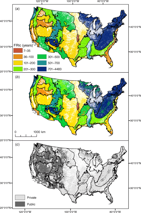
The fire history metrics were mapped across the CONUS and summarised for the burnable area within each of the 31 ecoregions. An area-based estimate of the Contemporary Fire Return Interval (FRIc) was calculated as the total area (e.g. ecoregion size) divided by the average area burned per year (Higuera et al. 2021). For example, if an area of interest was 10 000 km2 and an average of 200 km2 burned per year, then the predicted FRIc would be 50 years. The ecoregion averaged fire history metrics were correlated using a Spearman correlation (two-tailed) with a Bonferroni correction to test for overlap in the information provided by the different metrics.
Land ownership analysis
To demonstrate a potential application of these metrics, we compared the fire history metrics of public land to private land within each ecoregion. Public land was defined as units of land where its owner was identified as a local (2%), state (14%), or federal (84%) government entity from the Secured Areas Spatial Database (Center for Resilient Conservation Science (CRCS) 2021). Per ecoregion, state and local land comprised a too small percentage to analyse alone. Land protected either by an easement or by a non-governmental organisation was considered private land. As fire cause (natural or human) can also show a relationship to land ownership, the proportion of burned area caused by humans was reported, where fire events, size, and cause were reported by the Fire Program Analysis (FPA) Fire Occurrence Database (FOD) (1992–2018; Short 2021).
Furthermore, comparisons of fire metrics between public and private land can be complicated if the risk of fire spread is inherently different (Joppa and Pfaff 2009). Therefore, variables that are known to influence patterns of total burned area were summarised by ecoregion and land ownership, including annual precipitation, maximum monthly vapour pressure deficit (VPD), elevation, slope, and aspect (Holden et al. 2009). We acknowledge that these variables primarily influence wildfire instead of prescribed fire. Climate variables were derived from the Parameter-elevation Regressions on Independent Slopes Model Normals (PRISM (1981–2010); PRISM Climate Group 2021). For VPD, each pixel represented the maximum monthly VPD normal value. Slope, elevation, and aspect were determined from a USGS digital elevation model (DEM, 30 m spatial resolution). Aspect was converted to folded aspect, where higher values indicated more southerly slopes, to better represent radiation loads (McCune and Keon 2002):

A non-parametric Mann–Whitney U test, which tests if two data samples come from distinct populations, was used to determine if the fire metrics, specifically burn frequency and TSLB, or the underlying climate and topography significantly differed between public and private land. The Mann–Whitney U tests used a sample of burned points every 600 m (n = 669 848 points). Climate and topography were sampled every 4 km, but not limited to burned area extent (n = 326 523 points). We calculated Spearman correlations (two-tailed) to further test for correlations between the climate and topography variables themselves (n = 326 523 points). Bonferroni corrections were applied to all statistical tests to account for multiple statistical tests being performed simultaneously. Additionally, to test if biases in the location of public land across all ecoregions may explain differences in fire history metrics, the per-ecoregion public–private differences in the climate and topography were correlated with the per-ecoregion public–private differences in fire history metrics using a Spearman correlation (two-tailed).
Integrating contemporary metrics with complementary datasets
Contemporary fire history metrics are especially useful for guiding management decisions when compared to a ‘target’ fire regime, whether that target is the historical fire regime, or a climate-change adjusted target set to restore and maintain a specific ecosystem condition. In this analysis, the LANDFIRE FRI (30 m resolution) was used to represent the average period between fires under the presumed historical fire regime. The FRI is an output of the Biophysical Settings (BPS) models updated for the LANDFIRE 2016 Remap (LF 2.0.0) (Blankenship et al. 2021) and is calculated as the total number of simulation years divided by the total number of fires occurring in that cell (Pratt et al. 2006). We calculated two metrics that incorporated the historical FRI (FRIh).
The difference in years between the FRIh and TSLB (FRIh – TSLB) was calculated as a measure of where future fire is most needed to maintain target fire regimes. For instance, if the FRIh is 5 years, but a pixel last burned 20 years ago, then this metric would equal −15 years.
The number of fire cycles a pixel has missed over the record (n = 37 years) relative to the target was also derived. We first calculated the expected burn frequency or the number of times we would expect a pixel to have burned over the period (i.e. 37/FRIh). The observed burn frequency was then subtracted from the expected burn frequency (37/FRIh – FRQ). Values <1 indicate that a fire cycle has not yet been missed. This metric can provide insight into the feasibility of restoring target fire regimes.
Both metrics assume that under a target fire regime, a pixel would have burned at least once during the last 37 years, meaning that both metrics are meaningful in regions with short fire return intervals (e.g. Midwest and Southeast), and not meaningful in regions with long fire return intervals (e.g. Northeast). Consequently, examples of these metrics are shown at a local to regional-scale but not presented for CONUS.
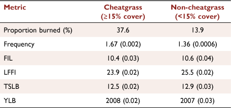
In addition to applications that can facilitate more fire, the metrics can also be used to facilitate management of invasive species such as cheatgrass (Bromus tectorum) that increase fire risk. We compared the fire history metrics with the distribution and percent cover (≥15% cover) of the invasive grass species cheatgrass across the Great Basin (Bradley et al. 2018). Unburnable and highly managed land cover types, as described in Study Area above, were masked from both datasets before a series of t-tests were performed to detect differences in the metrics between areas with and without cheatgrass.
Results
Ecoregion patterns of fire history metrics
Over the 37-year period, 11.7% of CONUS burned at least once. Within areas burned, 73.4% burned once, 16.7% burned twice, 4.9% burned three times, and 5.0% was documented as burning four times or more. Within areas burned, burn frequency averaged 1.41 with an average time since last burned of 13.9 years (Table 1). The proportion of each ecoregion mapped as burned over the 37-years ranged from 0.7% in the Northeast Mixed Woods to 74.1% in the Flint Hills of Kansas (Table 1). Other ecoregions also showed a substantial proportion mapped as burned over the time series including Southern California (51.9%), the Columbia Plateau in eastern Washington State (41.1%), Northern Basin and Range in Oregon and Idaho (32.4%), and Mediterranean California (28.5%) (Fig. 2, Table 1). Burn frequency was highly variable (Fig. 2a). Some ecoregions showed a lower proportion of total area burned but a higher burn frequency in areas that did burn, suggesting that some areas burn repeatedly and are clustered within a portion of the ecoregion. For example, in addition to the Flint Hills, which showed an average burn frequency or count of 6.8, the Temperate Prairies, Atlantic Coastal Plain, and Everglades also showed frequent burning with average burn frequencies of 2.1, 2.0, and 1.7, respectively (Table 1).

|

|
The YLB and associated TSLB provide information about the time elapsed since the most recent fire (Fig. 2b). The Coast Range and Arizona/New Mexico Plateau showed the longest average TSLB, of 18.1 and 16.4 years, respectively. The Flint Hills and the Sierra Nevada and Klamath Mountains showed the shortest TSLB of 5.2 and 8.0 years, respectively (Table 1). In the Sierra Nevada and Klamath Mountains, the short TSLB average is influenced by large recent fire years, including 2020, 2018, and 2017, as well as areas that have not reburned since older, large fire years such as 2002 and 2008. Additionally, the average number of years between repeat fire events (FIL) and the longest fire-free interval (LFFI) within the record were also provided as metrics. The Flint Hills showed the shortest FIL and LFFI, 5.4 and 15.7 years, respectively (Fig. 3) Short FIL averages, however, were not limited to ecoregions with a high proportion burned. The Interior Plateau and Central Plains both had a low proportion burned (1.3% and 2.3%, respectively) but repeat burns resulted in low FIL averages, 6.6 and 6.9 years, respectively. Within the LFFI metric, Southern California, the Atlantic Coastal Plain and the Cold deserts all showed short average LFFI, averaging 23.8 years for all three ecoregions (Table 1).

|
When we correlated the ecoregion-specific fire history metrics, the LFFI was negatively correlated with FRQ (r = −0.73, P < 0.05) and positively correlated with FRIc (r = 0.59, P <0.05). The significance of these correlations persisted after removing the Flint Hills ecoregion. In general, however, except for TSLB and YLB, which present the same information in a different format, the fire history metrics were largely not significantly correlated with one another, suggesting their unique contributions. In Fig. 3, the FRQ, TSLB, FIL, and LFFI are all shown for the Flint Hills in Kansas, demonstrating how each metric provides complementary data on the contemporary fire regime. Appropriate application of the metrics requires consideration of burned area missed by the Landsat BA Product. Predicted rates of burned area omission ranged from 25% in the Coast Range to 67% in the Everglades (Table 1).
Influence of ownership on fire metrics
Public land represents 28.7% of the CONUS study area but is unevenly distributed across CONUS (Fig. 4). While the Cold Desert and Northern Basin and Range are >85% public land, the Flint Hills and Temperate Prairies contain <5% public land. Ownership-based comparisons of fire history metrics are less meaningful in ecoregions with a very low or high percent of public land but can still be relevant for regional fire management. Of the 31 ecoregions, 17 had a public land percentage of 20–80% and are hereafter referred to as the subset. A larger proportion of public land was mapped as burned, relative to private land in 19 of the 31 ecoregions (13 of the 17 subset). Similarly, the FRIc was shorter for public than private land in 25 of the 31 ecoregions (13 of the 17 subset), and shorter by an average of −136% across all ecoregions (−50% in subset ecoregions; Table 2). Prominent examples include Southern California, where the FRIc was 47 years on public land in contrast to 60 years on private land (28% difference); the Sierra Nevada and Klamath Mountains, where the FRIc was 113 years on public land, but 209 years on private land (84% difference), and the Rocky Mountains where the FRIc was much closer, 277 years on public land compared to 312 years on private land (13% difference) (Table 2, Fig. 4). Within areas mapped as burned at least once, TSLB on public land was significantly shorter for 14 of 31 ecoregions (six of 17 subset) and significantly longer for three of 31 ecoregions (three of 17 subset). The FRQ was significantly longer on public lands for nine of 31 ecoregions (two of 17 subset) and significantly shorter for five of 31 (two of 17) (Table 2).
|

|
Many of the ecoregions also showed significant public–private differences in landscape parameters, including elevation (25 of 31 ecoregions, 15 of 17 subset), slope (24 of 31 ecoregions, 15 of 17 subset), annual precipitation (23 of 31 ecoregions, 13 of 17 subset), and VPDmax (21 of 31 ecoregions, 13 of 17 subset) (Table 3). The data suggest that public–private differences in landscape parameters can help explain differences in fire regimes, but this finding, of course, does not prohibit landscape management from also influencing these differences. As evidence, the proportion of public land was negatively correlated with the proportion of burned area caused by humans (r= −0.83, Table 2), suggesting that public–private differences in fire history metrics are also influenced by land use practices.

|
We found that when public land had more precipitation than private land, it tended to have a lower burn frequency (Table 4). Additionally, Southern California, the Sierra Nevada-Klamath Mountains, and West-Central Semi-Arid Prairies all showed a significant difference in one of the burn metrics (TSLB or FRQ) as well as significant differences in 3–5 of the landscape parameters (Tables 2, 3). However, differences in public–private landscape parameters did not necessarily result in differences in fire metrics. The Idaho Batholith, Rocky Mountains, and Mediterranean California all showed no significant differences in burn metrics but significant differences in at least three of the landscape parameters. Further, some of the landscape parameters were correlated with one another across CONUS. Precipitation, for example, was negatively correlated with elevation (r = −0.64, P < 0.01) and VPDmax (r = −0.67, P < 0.01), and elevation was positively correlated with slope (r = 0.39, P < 0.01). Where we observed ecoregions with public–private differences in fire regimes, but very little difference in landscape parameters, landscape management may be playing a more substantial role. The Mississippi Plains and Central Plains all showed significant differences in FRQ and TSLB but a significant difference only in slope for the first, and precipitation for the second, and both showed >95% of the burned area identified as human-caused (Tables 2, 3).

|
Comparison of contemporary metrics with complementary datasets
While the fire history metrics can be useful alone, combining the metrics with baseline datasets, such as historical or modelled fire regimes or vegetation datasets, can provide additional insights. The LANDFIRE FRI (FRIh) indicates that 53.4% of CONUS has a historical fire return interval of ≤37 years. Comparisons of the metrics with the FRIh will be more applicable in regions with frequent fire (FRIh <37 years). In Fig. 5 we show an example from northern Florida to southern Georgia of how the TSLB and FRIh can be subtracted from one another to identify areas most in need of fire for restoration. Additionally, the FRIh and FRQ can be used to calculate the number of burn cycles missed, where target burn cycles are defined by the FRIh. In Fig. 6, we show that in northern California, much of the study area had an FRIh of 6–15 years, but relative to the documented FRQ, much of the area has missed 1–3 fire cycles over the 37-year period.

|

|
When the fire history metrics were compared with cheatgrass cover, we found that portions of the Great Basin with >15% cheatgrass cover showed a greater proportion burned (37.6% compared to 13.9%) as well as a significantly (P < 0.01) shorter FIL, LFFI, TSLB, and YLB and a higher burn frequency (Table 5, Fig. 7). We note that discrepancies in data collection ranges, however, can complicate comparisons. While the fire history metrics were derived from the 1984–2020 period, the cheatgrass distribution was derived from data collected between 2005 and 2016.
|

|
Discussion
While the distribution of burned area and burn frequency presented across CONUS is consistent with spatial fire patterns identified by others (Eidenshink et al. 2007; Short 2015; Giglio et al. 2016), the diversity of fire regimes across the U.S. makes it challenging for a single set of comparative metrics to adequately describe them. The FRQ, TSLB, and YLB metrics are useful across a wide range of fire regimes, and can be used to inform risk of wildfire, answer fire-management questions, or support fire model parameterisation. The FIL and LFFI, alternatively, provide data on the distribution of fire events across the period of record and can help guide land management in regions with frequent fire, such as the Midwest and Southeast. Alternatively, in regions with longer fire return intervals, such as the Northeast or high-elevation conifer ecosystems across the western U.S., an area-based FRIc may provide a better understanding of the contemporary fire regime, relative to the pixel-based metrics. Further, if fire history metrics are desired at a finer spatial unit, alternative base units, such as pyromes (Short et al. 2020) can be used.
The Landsat BA Product has documented omission and commission error rates that vary by land cover and propagate to the fire history metrics. In regions with rapid post-fire recovery, such as grasslands or wetlands, or where low intensity or understory fires are common, such as pine plantations, omission errors in the Landsat BA Product are higher (Vanderhoof et al. 2021) and therefore FRQ may be underestimated, while TSLB, LFFI, FIL, and FRIc may all be overestimated. Conversely, commission error in the Landsat BA Product is highest in cultivated crops and pasture/hay land cover types (Hawbaker et al. 2020a), which may overestimate FRQ and underestimate the remaining metrics. Therefore, consideration of variable error rates within the Landsat BA Product is essential when interpreting fire history metrics.
The ability and resources to manage wildfire risk, implement prescribed fire, and respond to active wildfires may all be influenced by patterns of land ownership (Andam et al. 2008; Starrs et al. 2018). Public land in the majority of ecoregions showed a greater proportion mapped as burned, a shorter FRIc, and where burns had occurred, a higher average burn frequency and shorter average TSLB. However, the proportion of burned area attributed as human-caused increased as more of the ecoregion was classified as private land. Further, the public–private lands, per ecoregion, also often showed differences in climate and topography, but the relationship between fire history metrics and landscape parameters was not consistent across ecoregions, suggesting the integrated influence of landscape parameters, land use, and land management on public–private differences, and the potential opportunity to further engage private landowners in fire policy and decision making. Support for prescribed fire has been documented among private landowners, for example, but that support tends to occur when communities are aware of the ecological benefits of fire, concerns persist about human and property safety, and there is adequate communication on fire logistics (Piatek and McGill 2010; Gordon et al. 2020). Additionally, while datasets distinguishing fire cause are typically biased towards large fires that occurred on public land (Short 2015; Fusco et al. 2019), incorporating datasets that help distinguish prescribed fires from wildfires (Short 2021) can help explain differences in burning rates on public versus private lands, as well as potentially distinguish where changes in fire regime are attributable to changes in land management relative to factors such as climate change. For instance, distinguishing shifts in fire history metrics in response to climate change may be an easier task in ecoregions with a lower proportion of human-caused burned area, such as the Cascades, Idaho Batholith, and Northern Basin and Range (Table 2).
The Landsat fire history metrics, alone, or combined with target fire regimes, for instance comparing the FRIh with the TSLB or combining the FRIh with burn frequency to estimate fire cycles missed, may be useful for diverse land management applications. Both measures focus on recent fire activity instead of modelled vegetation condition, and therefore provide data distinct from LANDFIRE’s fire return interval departure (FRID; Blankenship et al. 2021). One potential application would be to guide land management in grasslands across the Midwest, where past fire suppression has led to the expansion of invasives and woody plant species (Engle et al. 2008), as demonstrated by our result that areas dominated by cheatgrass in the Great Basin showed more frequent fire, a finding supported by Bradley et al. (2018). A second potential application would be supporting management of southeastern longleaf pine (Pinus palustris) and other southern upland pine (P. echinata, P. taeda, and P. elliottii) forest communities for at-risk wildlife species that benefit from frequent fire (Van Lear et al. 2005). However, as the climate continues to change, and acts upon current vegetation conditions, it may become less appropriate to use historical fire regimes as a target (Liu and Wimberly 2016; Perkins et al. 2019). In addition, climate change can also make it more challenging to meet prescribed fire goals, for example, rising summer temperatures across the Southeast will reduce the number of days suitable for prescribed burning (Chiodi et al. 2019; Kupfer et al. 2020). Therefore, as climate-induced shifts in fire activity continue, future predictions of fire risk and management will benefit from the direct use of contemporary fire history metrics and comparing contemporary fire history metrics to data-driven target fire regimes that maximise ecosystem resiliency instead of historical fire regime data.
Conclusion
Fire history metrics such as burn frequency, time and year since last burn, and fire regime characteristics (LFFI, FIL, and FRI) enable rapidly increasing amounts of burned area data to be collapsed into a handful of data layers that can be used efficiently by diverse stakeholders. Fire regimes vary widely across the U.S., and the appropriate or useful fire metric(s) may depend on the local or regional amount and frequency of burning. The difference in fire regimes between public and private land across the U.S. highlights the importance of accurately tracking fire activity across both public and private land. The fire history metrics presented here may help manage future fire risk, meet national fire-related goals, and prioritise areas to focus increased engagement with private landowners. Continued progress towards accurate and complete mapping of burned area, and the consolidation of burned area products into useful and relevant fire history metrics is critical to manage ecosystem condition under climate change and control the growing economic costs of wildfire damage and suppression.
Data availability
All datasets used in this study are publicly available including the annual Landsat BA products (https://doi.org/10.5066/P9QKHKTQ) and the Landsat Fire History Metrics (https://doi.org/10.5066/P98996IH), which will be published concurrently with the publication.
Conflicts of interest
The authors declare no conflicts of interest.
Declaration of funding
We would like to acknowledge funding for this research from the U.S. Geological Survey’s Core Science Systems Mission Area, National Land Imaging Program, Land Change Science Program, and Community for Data Integration.
Acknowledgements
We appreciate helpful comments and revisions on earlier versions from Morgan Varner and the anonymous reviewers. Any use of trade, firm, or product names is for descriptive purposes only and does not imply endorsement by the U.S. Government.
References
Addington RN, Tavernia BG, Caggiano MD, Thompson MP, Lawhon JD, Sanderson JS (2020) Identifying opportunities for the use of broadcast prescribed fire on Colorado’s Front Range. Forest Ecology and Management 458, 117655| Identifying opportunities for the use of broadcast prescribed fire on Colorado’s Front Range.Crossref | GoogleScholarGoogle Scholar |
Andam KS, Ferraro PJ, Pfaff A, Sanchez-Azofeifa GA, Robalino JA (2008) Measuring the effectiveness of protected area networks in reducing deforestation. Proceedings of the National Academy of Sciences 105, 16089–16094.
| Measuring the effectiveness of protected area networks in reducing deforestation.Crossref | GoogleScholarGoogle Scholar |
Balch JK, Bradley BA, Abatzoglou JT, Nagy RC, Fusco EJ, Mahood AL (2017) Human-started wildfires expand the fire niche across the United States. Proceedings of the National Academy of Sciences 114, 2946–2951.
| Human-started wildfires expand the fire niche across the United States.Crossref | GoogleScholarGoogle Scholar |
Blankenship K, Swaty R, Hall KR, Hagen S, Pohl K, Shlisky Hunt A, Patton J, Frid L, Smith J (2021) Vegetation dynamics models: a comprehensive set for natural resource assessment and planning in the United States. Ecosphere 12, e03484
| Vegetation dynamics models: a comprehensive set for natural resource assessment and planning in the United States.Crossref | GoogleScholarGoogle Scholar |
Bradley BA, Curtis CA, Fusco EJ, Abatzoglou JT, Balch JK, Dadashi S, Tuanmu MN (2018) Cheatgrass (Bromus tectorum) distribution in the intermountain Western United States and its relationship to fire frequency, seasonality, and ignitions. Biological Invasions 20, 1493–1506.
| Cheatgrass (Bromus tectorum) distribution in the intermountain Western United States and its relationship to fire frequency, seasonality, and ignitions.Crossref | GoogleScholarGoogle Scholar |
Braun de Torrez EC, Ober HK, McCleery RA (2018) Restoring historical fire regimes increases activity of endangered bats. Fire Ecology 14, 9
| Restoring historical fire regimes increases activity of endangered bats.Crossref | GoogleScholarGoogle Scholar |
Busenberg G (2004) Wildfire management in the United States: The evolution of a policy failure. Review of Policy Research 21, 145–156.
| Wildfire management in the United States: The evolution of a policy failure.Crossref | GoogleScholarGoogle Scholar |
Cattau ME, Wessman C, Mahood A, Balch JK (2020) Anthropogenic and lightning-started fires are becoming larger and more frequent over a longer season length in the U.S.A. Global Ecology and Biogeography 29, 668–681.
| Anthropogenic and lightning-started fires are becoming larger and more frequent over a longer season length in the U.S.A.Crossref | GoogleScholarGoogle Scholar |
Center for Resilient Conservation Science (CRCS) (2021) ‘Secured areas spatial database (CONUS).’ (The Nature Conservancy: Boston, MA) Available at https://tnc.maps.arcgis.com/home/item.html?id=e033e6bf6069459592903a04797b8b07 [last accessed 27 October 2021]
Chiodi AM, Larkin NK, Varner JM, Hiers JK (2019) Sensitivity of prescribed burn weather windows to atmospheric dispersion parameters over southeastern USA. International Journal of Wildland Fire 28, 589–600.
| Sensitivity of prescribed burn weather windows to atmospheric dispersion parameters over southeastern USA.Crossref | GoogleScholarGoogle Scholar |
Chuvieco E, Mouillot F, van der Werf GR, San Miguel J, Tanase M, Koutsias N, García M, Yebra M, Padilla M, Gitas I, Heil A, Hawbaker TJ, Giglio L (2019) Historical background and current developments for mapping burned area from satellite Earth observation. Remote Sensing of Environment 225, 45–64.
| Historical background and current developments for mapping burned area from satellite Earth observation.Crossref | GoogleScholarGoogle Scholar |
Dennison PE, Brewer SC, Arnold JD, Moritz MA (2014) Large wildfire trends in the western United States, 1984-2011. Geophysical Research Letters 41, 2928–2933.
| Large wildfire trends in the western United States, 1984-2011.Crossref | GoogleScholarGoogle Scholar |
Donovan VM, Wonkka CL, Twidwell D (2017) Surging wildfire activity in a grassland biome. Geophysical Research Letters 44, 5986–5993.
| Surging wildfire activity in a grassland biome.Crossref | GoogleScholarGoogle Scholar |
Eidenshink J, Schwind B, Brewer K, Zhu ZL, Quayle B, Howard S (2007) A project for monitoring trends in burn severity. Fire Ecology 3, 3–21.
| A project for monitoring trends in burn severity.Crossref | GoogleScholarGoogle Scholar |
Engle DM, Coppedge BR, Fuhlendorf SD (2008) From the dust bowl to the green glacier: human activity and environmental change in Great Plains grasslands. In ‘Western North American Juniperus communities: a dynamic vegetation type’. (Ed. OW Van Auken) (Springer-Verlag: New York, NY)
Frost CC (1998) Presettlement fire frequency regimes of the United States: a first approximation. In ‘Fire in ecosystem management: shifting the paradigm from suppression to prescription. Tall Timbers Fire Ecology Conference Proceedings, No. 20’. (Eds TL Pruden, LA Brennan) pp. 70–81. (Tall Timbers Research Station: Tallahassee, FL)
Fusco EJ, Finn JT, Abatzoglou JT, Balch JK, Dadashi S, Bradley BA (2019) Detection rates and biases of fire observations from MODIS and agency reports in the conterminous United States. Remote Sensing of Environment 220, 30–40.
| Detection rates and biases of fire observations from MODIS and agency reports in the conterminous United States.Crossref | GoogleScholarGoogle Scholar |
Gao P, Terando AJ, Kupfer JA, Varner JM, Stambaugh MC, Lei TL, Hiers JK (2021) Robust projections of future fire probability for the conterminous United States. Science of the Total Environment 789, 147872
| Robust projections of future fire probability for the conterminous United States.Crossref | GoogleScholarGoogle Scholar |
Giglio L, Schroeder W, Justice CO (2016) The Collection 6 MODIS active fire detection algorithm and fire products. Remote Sensing of Environment 178, 31–41.
| The Collection 6 MODIS active fire detection algorithm and fire products.Crossref | GoogleScholarGoogle Scholar |
Gordon JS, Willis JL, Grala RK (2020) Public and forest landowner attitudes towards longleaf pine ecosystem restoration using prescribed fire. Canadian Journal of Forest Research 50, 917–924.
| Public and forest landowner attitudes towards longleaf pine ecosystem restoration using prescribed fire.Crossref | GoogleScholarGoogle Scholar |
Guyette RP, Stambaugh MC, Dey DC, Muzika R-M (2012) Predicting Fire Frequency with Chemistry and Climate. Ecosystems 15, 322–335.
| Predicting Fire Frequency with Chemistry and Climate.Crossref | GoogleScholarGoogle Scholar |
Hagmann RK, Hessburg PF, Prichard SJ, Povak NA, Brown PM, Fulé PZ, Keane RE, Knapp EE, Lydersen JM, Metlen KL, Reilly MJ, Sánchez Meador AJ, Stephens SL, Stevens JT, Taylor AH, Yocom LL, Battaglia MA, Churchill DJ, Daniels LD, Falk DA, Henson P, Johnston JD, Krawchuk MA, Levine CR, Meigs GW, Merschel AG, North MP, Safford HD, Swetnam TW, Waltz AEM (2021) Evidence for widespread changes in the structure, composition, and fire regimes of western North American forests. Ecological Applications 31, e02431
| Evidence for widespread changes in the structure, composition, and fire regimes of western North American forests.Crossref | GoogleScholarGoogle Scholar |
Hawbaker TJ, Vanderhoof MK, Schmidt GL, Beal YJ, Picotte JJ, Takacs JD, Falgout JT, Dwyer JL (2020a) The Landsat burned area algorithm and products for the conterminous United States. Remote Sensing of Environment 244, 111801
| The Landsat burned area algorithm and products for the conterminous United States.Crossref | GoogleScholarGoogle Scholar |
Hawbaker TJ, Vanderhoof MK, Schmidt GL, Beal YJG, Picotte JJ, Takacs JD, Falgout JT, Dwyer JL (2020b) The Landsat Burned Area products for the conterminous United States (ver. 3.0, March 2022). U.S. Geological Survey data release.
| Crossref |
Higuera PE, Shuman BN, Wolf KD (2021) Rocky Mountain subalpine forests now burning more than any time in recent millennia. Proceedings of the National Academy of Sciences 118, e2103135118
| Rocky Mountain subalpine forests now burning more than any time in recent millennia.Crossref | GoogleScholarGoogle Scholar |
Holden ZA, Morgan P, Evans JS (2009) A predictive model of burn severity based on 20-year satellite-inferred burn severity data in a large southwestern US wilderness area. Forest Ecology and Management 258, 2399–2406.
| A predictive model of burn severity based on 20-year satellite-inferred burn severity data in a large southwestern US wilderness area.Crossref | GoogleScholarGoogle Scholar |
Homer C, Dewitz J, Jin S, Xian G, Costello C, Danielson P, Gass L, Funk M, Wickham J, Stehman S, Auch R, Riitters K (2020) Conterminous United States land cover change patterns 2001–2016 from the 2016 National Land Cover Database. ISPRS Journal of Photogrammetry and Remote Sensing 162, 184–199.
| Conterminous United States land cover change patterns 2001–2016 from the 2016 National Land Cover Database.Crossref | GoogleScholarGoogle Scholar |
Humber ML, Boschetti L, Giglio L, Justice CO (2019) Spatial and temporal intercomparison of four global burned area products. International Journal of Digital Earth 12, 460–484.
| Spatial and temporal intercomparison of four global burned area products.Crossref | GoogleScholarGoogle Scholar |
Jolly WM, Cochrane MA, Freeborn PH, Holden ZA, Brown TJ, Williamson GJ, Bowman DMJS (2015) Climate-induced variations in global wildfire danger from 1979 to 2013. Nature Communications 6,
| Climate-induced variations in global wildfire danger from 1979 to 2013.Crossref | GoogleScholarGoogle Scholar |
Joppa LN, Pfaff A (2009) High and far: Biases in the location of protected areas. PLoS One 4, e8273
| High and far: Biases in the location of protected areas.Crossref | GoogleScholarGoogle Scholar |
Keane RE, Rollins M, Zhu ZL (2007) Using simulated historical time series to prioritize fuel treatments on landscapes across the United States: The LANDFIRE prototype project. Ecological Modelling 204, 485–502.
| Using simulated historical time series to prioritize fuel treatments on landscapes across the United States: The LANDFIRE prototype project.Crossref | GoogleScholarGoogle Scholar |
Keeley JE, Syphard AD (2021) Large California wildfires: 2020 fires in historical context. Fire Ecology 17, 22
| Large California wildfires: 2020 fires in historical context.Crossref | GoogleScholarGoogle Scholar |
Keeley JE, Pfaff A, Caprio AC (2021) Contrasting prescription burning and wildfires in California Sierra Nevada national parks and adjacent national forests. International Journal of Wildland Fire 30, 255–268.
| Contrasting prescription burning and wildfires in California Sierra Nevada national parks and adjacent national forests.Crossref | GoogleScholarGoogle Scholar |
Kramer A, Jones GM, Whitmore SA, Keane JJ, Atuo FA, Dotters BP, Sawyer SC, Stock SL, Gutiérrez RJ, Peery MZ (2021) California spotted owl habitat selection in a fire-managed landscape suggests conservation benefit of restoring historical fire regimes. Forest Ecology and Management 479, 118576
| California spotted owl habitat selection in a fire-managed landscape suggests conservation benefit of restoring historical fire regimes.Crossref | GoogleScholarGoogle Scholar |
Kupfer JA, Terando AJ, Gao P, Teske C, Hiers JK (2020) Climate change projected to reduce prescribed burning opportunities in the south-eastern United States. International Journal of Wildland Fire 29, 764–778.
| Climate change projected to reduce prescribed burning opportunities in the south-eastern United States.Crossref | GoogleScholarGoogle Scholar |
Leys BA, Commerford JL, McLauchlan KK (2017) Reconstructing grassland fire history using sedimentary charcoal: Considering count, size and shape. PLoS One 12, e0176445
| Reconstructing grassland fire history using sedimentary charcoal: Considering count, size and shape.Crossref | GoogleScholarGoogle Scholar |
Liu Z, Wimberly MC (2016) Direct and indirect effects of climate change on projected future fire regimes in the western United States. Science of the Total Environment 542, Part A, 65–75.
| Direct and indirect effects of climate change on projected future fire regimes in the western United States.Crossref | GoogleScholarGoogle Scholar |
Liu Y, Achtemeier GL, Goodrick SL, Jackson WA (2010) Important parameters for smoke plume rise simulation with Daysmoke. Atmospheric Pollution Research 1, 250–259.
| Important parameters for smoke plume rise simulation with Daysmoke.Crossref | GoogleScholarGoogle Scholar |
McBride JR (1983) Analysis of tree rings and fire scars to establish fire history. Tree-Ring Bulletin 43, 51–67.
McCune B, Keon D (2002) Equations for potential annual direct incident radiation and heat load. Journal of Vegetation Science 13, 603–606.
| Equations for potential annual direct incident radiation and heat load.Crossref | GoogleScholarGoogle Scholar |
Mensing S, Livingston S, Barker P (2006) Long-term fire history in great basin sagebrush reconstructed from macroscopic charcoal in spring sediments, Newark Valley, Nevada. Western North American Naturalist 66, 64–77.
| Long-term fire history in great basin sagebrush reconstructed from macroscopic charcoal in spring sediments, Newark Valley, Nevada.Crossref | GoogleScholarGoogle Scholar |
Miller JD, Collins BM, Lutz JA, Stephens SL, van Wagtendonk JW, Yasuda DA (2012) Differences in wildfires among ecoregions and land management agencies in the Sierra Nevada region, California, USA. Ecosphere 3, 80
| Differences in wildfires among ecoregions and land management agencies in the Sierra Nevada region, California, USA.Crossref | GoogleScholarGoogle Scholar |
Morgan P, Hardy CC, Swetnam TW, Rollins MG, Long DG (2001) Mapping fire regimes across time and space: Understanding coarse and fine-scale fire patterns. International Journal of Wildland Fire 10, 329–342.
| Mapping fire regimes across time and space: Understanding coarse and fine-scale fire patterns.Crossref | GoogleScholarGoogle Scholar |
Nauslar NJ, Abatzoglou JT, Marsh PT (2018) The 2017 North Bay and Southern California fires: A case study. Fire 1, 18
| The 2017 North Bay and Southern California fires: A case study.Crossref | GoogleScholarGoogle Scholar |
Nowell HK, Holmes CD, Robertson K, Teske C, Hiers JK (2018) A new picture of fire extent, variability, and drought interaction in prescribed fire landscapes: insights from Florida government records. Geophysical Research Letters 45, 7874–7884.
| A new picture of fire extent, variability, and drought interaction in prescribed fire landscapes: insights from Florida government records.Crossref | GoogleScholarGoogle Scholar |
Omernik JM, Griffith GE (2014) Ecoregions of the conterminous United States: evolution of a hierarchical spatial framework. Environmental Management 54, 1249–1266.
| Ecoregions of the conterminous United States: evolution of a hierarchical spatial framework.Crossref | GoogleScholarGoogle Scholar |
Parks SA, Miller C, Parisien MA, Holsinger LM, Dobrowski SZ, Abatzoglou J (2015) Wildland fire deficit and surplus in the western United States, 1984–2012. Ecosphere 6, 275
| Wildland fire deficit and surplus in the western United States, 1984–2012.Crossref | GoogleScholarGoogle Scholar |
Perkins LB, Ahlering M, Larson DL (2019) Looking to the future: key points for sustainable management of northern Great Plains grasslands. Restoration Ecology 27, 1212–1219.
| Looking to the future: key points for sustainable management of northern Great Plains grasslands.Crossref | GoogleScholarGoogle Scholar |
Piatek KB, McGill DW (2010) Perceptions of private forest owners in West Virginia on the use of prescribed fire in forestry. Small-Scale Forestry 9, 227–241.
| Perceptions of private forest owners in West Virginia on the use of prescribed fire in forestry.Crossref | GoogleScholarGoogle Scholar |
Pratt S, Holsinger L, Keane RE (2006) Chapter 10 - Using simulation modeling to assess historical reference conditions for vegetation and fire regimes for the LANDFIRE Prototype Project. In ‘The LANDFIRE Prototype Project: nationally consistent and locally relevant geospatial data for wildland fire management General Technical Reports RMRS-GTR-175’. (Eds Rollins, MG, Frame, CK, tech.) pp. 277–314. (U.S. Department of Agriculture, Forest Service, Rocky Mountain Research Station: Fort Collins)
PRISM Climate Group (2021) ‘Descriptions of PRISM spatial climate datasets for the conterminous United States.’ (Oregon State University) Available at http://prism.oregonstate.edu [created 4 February 2004]
Ren X, Lv Y, Li M (2017) Evaluating differences in forest fragmentation and restoration between western natural forests and southeastern plantation forests in the United States. Journal of Environmental Management 188, 268–277.
| Evaluating differences in forest fragmentation and restoration between western natural forests and southeastern plantation forests in the United States.Crossref | GoogleScholarGoogle Scholar |
Roos CI, Rittenour TM, Swetnam TW, Loehman RA, Hollenback KL, Liebmann MJ, Rosenstein DD (2020) Fire suppression impacts on fuels and fire intensity in the western U.S.: Insights from archaeological luminescence dating in northern New Mexico. Fire 3, 32
| Fire suppression impacts on fuels and fire intensity in the western U.S.: Insights from archaeological luminescence dating in northern New Mexico.Crossref | GoogleScholarGoogle Scholar |
Ryan KC (2002) Dynamic interactions between forest structure and fire behavior in boreal ecosystems. Silva Fennica 36, 13–39.
| Dynamic interactions between forest structure and fire behavior in boreal ecosystems.Crossref | GoogleScholarGoogle Scholar |
Ryan KC, Knapp EE, Varner JM (2013) Prescribed fire in North American forests and woodlands: history, current practice, and challenges. Frontiers in Ecology and the Environment 11, e15–e24.
| Prescribed fire in North American forests and woodlands: history, current practice, and challenges.Crossref | GoogleScholarGoogle Scholar |
Safford HD, Van de Water KM (2014) Using fire return interval departure (FRID) analysis to map spatial and temporal changes in fire frequency on national forest lands in California. In ‘Res. Pap. PSW-RP-266’. 59 p. (U.S. Department of Agriculture, Forest Service, Pacific Southwest Research Station: Albany, CA)
Schoennagel T, Nelson CR, Theobald DM, Carnwath GC, Chapman TB (2009) Implementation of National Fire Plan treatments near the wildland-urban interface in the western United States. Proceedings of the National Academy of Sciences 106, 10706–10711.
| Implementation of National Fire Plan treatments near the wildland-urban interface in the western United States.Crossref | GoogleScholarGoogle Scholar |
Schultz CA, McCaffrey SM, Huber-Stearns HR (2019) Policy barriers and opportunities for prescribed fire application in the western United States. International Journal of Wildland Fire 28, 874–884.
| Policy barriers and opportunities for prescribed fire application in the western United States.Crossref | GoogleScholarGoogle Scholar |
Scott JH, Gilbertson-Day JW, Moran C, Dillon GK, Short KC, Vogler KC. (2020) Wildfire Risk to Communities: Spatial datasets of landscape-wide wildfire risk components for the United States. Fort Collins, CO: Forest Service Research Data Archive. Updated 25 November 2020.
| Crossref |
Short KC (2015) Sources and implications of bias and uncertainty in a century of US wildfire activity data. International Journal of Wildland Fire 24, 883–891.
| Sources and implications of bias and uncertainty in a century of US wildfire activity data.Crossref | GoogleScholarGoogle Scholar |
Short KC (2021) ‘Spatial wildfire occurrence data for the United States, 1992-2018 [FPA_FOD_20210617]’, 5th edn. (Forest Service Research Data Archive: Fort Collins, CO)
| Crossref |
Short, KC, Grenfell IC, Riley KL, Vogler K (2020) ‘Pyromes of the conterminous United States.’ (Forest Service Research Data Archive: Fort Collins, CO)
| Crossref |
Singleton MP, Thode AE, Sánchez Meador AJ, Iniguez JM (2019) Increasing trends in high-severity fire in the southwestern USA from 1984 to 2015. Forest Ecology and Management 433, 709–719.
| Increasing trends in high-severity fire in the southwestern USA from 1984 to 2015.Crossref | GoogleScholarGoogle Scholar |
Starrs CF, Butsic V, Stephens C, Stewart W (2018) The impact of land ownership, firefighting, and reserve status on fire probability in California. Environmental Research Letters 13, 034025
| The impact of land ownership, firefighting, and reserve status on fire probability in California.Crossref | GoogleScholarGoogle Scholar |
Teske C, Vanderhoof MK, Hawbaker TJ, Noble J, Hiers JK (2021) Using the Landsat burned area products to derive fire history relevant for fire management and conservation in the state of Florida, southeastern USA. Fire 4, 26
| Using the Landsat burned area products to derive fire history relevant for fire management and conservation in the state of Florida, southeastern USA.Crossref | GoogleScholarGoogle Scholar |
Twidwell D, Rogers WE, Fuhlendorf SD, Wonkka CL, Engle DM, Weir JR, Kreuter UP, Taylor Jr CA (2013) The rising Great Plains fire campaign: citizens’ response to woody plant encroachment. Frontiers in Ecology and the Environment 11, e64–e71.
| The rising Great Plains fire campaign: citizens’ response to woody plant encroachment.Crossref | GoogleScholarGoogle Scholar |
Van Lear DH, Carroll WD, Kapeluck PR, Johnson R (2005) History and restoration of the longleaf pine-grassland ecosystem: Implications for species at risk. Forest Ecology and Management 211, 150–165.
| History and restoration of the longleaf pine-grassland ecosystem: Implications for species at risk.Crossref | GoogleScholarGoogle Scholar |
Vanderhoof MK, Hawbaker TJ, Teske C, Ku A, Noble J, Picotte J (2021) Mapping wetland burned area from Sentinel-2 across the southeastern United States and its contributions relative to Landsat-8 (2016–2019). Fire 4, 52
| Mapping wetland burned area from Sentinel-2 across the southeastern United States and its contributions relative to Landsat-8 (2016–2019).Crossref | GoogleScholarGoogle Scholar |
Voelker SL, Merschel AG, Meinzer FC, Ulrich DEM, Spies TA, Still CJ (2018) Fire deficits have increased drought sensitivity in dry conifer forests: fire frequency and tree-ring carbon isotope evidence from Central Oregon. Global Change Biology 25, 1247–1262.
| Fire deficits have increased drought sensitivity in dry conifer forests: fire frequency and tree-ring carbon isotope evidence from Central Oregon.Crossref | GoogleScholarGoogle Scholar |
Wiesner S, Staudhammer CL, Javaheri CL, Hiers JK, Boring LR, Mitchell RJ, Starr G (2019) The role of understory phenology and productivity in the carbon dynamics of longleaf pine savannas. Ecosphere 10, e02675
| The role of understory phenology and productivity in the carbon dynamics of longleaf pine savannas.Crossref | GoogleScholarGoogle Scholar |
Yang J, Tian H, Tao B, Ren W, Pan S, Liu Y, Wang Y (2015) A growing importance of large fires in conterminous United States during 1984–2012. Journal of Geophysical Research: Biogeosciences 120, 2625–2640.
| A growing importance of large fires in conterminous United States during 1984–2012.Crossref | GoogleScholarGoogle Scholar |