Investigating the dynamic behaviour of merging fire fronts
Alexander I. Filkov A * , Brendan Holyland A , Brett Cirulis A , Khalid Moinuddin B , Duncan Sutherland C , Jason Sharples C , James Hilton D , Craig B. Clements E and Trent D. Penman A
A
B
C
D
E
Abstract
Merging fire fronts have been associated with rapid fire spread and extremely destructive wildfires, yet few studies have characterised these behaviours outside the laboratory.
This study aimed to improve our understanding of merging fire fronts using two experimental harvested crop burns in Victoria, Australia, in 2021.
Unmanned aerial vehicles (UAVs) were used to capture the propagation of fire fronts exhibiting different merging behaviours, including forward and backward (V-shaped) junction fires, linear and coalescing fronts.
A fourfold increase in fire length of forward junction fires led to a doubling of the mean rate of spread (ROS). Forward junction fires spread, on average, three times faster than linear fire fronts, and they also exhibited higher temperature peaks during merging. An increase in the junction angle during merging was observed for all initial junction angles except 60°–90°, but in contrast to laboratory studies, no significant decrease in the ROS was found as the junction angle increased.
Our findings suggest that junction fires may lead to other dynamic fire behaviours (DFBs) involving pyroconvective interactions, firebrand showers, fire whirls and other effects.
These results demonstrate the need for further research into merging fire fronts dynamics, to improve operational fire behaviour models.
Keywords: fire behaviour, junction fires, merging fire fronts, rate of spread, spot fire coalescence, temperature, thermal characteristics, wildfires.
Glossary of terms
| Dynamic fire behaviour (aka Extreme fire behaviour) | A physical phenomenon of fire behaviour that involves rapid changes of fire behaviour and occurs under specific conditions which has the potential to be identified, described and modelled (Filkov et al. 2020a). |
| Linear fire front (head fire) | The fastest-spreading part of a fires perimeter, typically located on the side toward which the wind is blowing (NWCG 2017). |
| Junction fire (or junction fire fronts) | A fire formed by the merging of two lines of fire intersecting at an oblique angle, known as the junction angle (Raposo et al. 2018). Also referred to as ‘jump fires.’ |
| Forward junction fire/forward linear fire front | A junction or linear fire front that spreads in the direction of the wind. |
| Backward junction fire/backward linear fire front | A junction or linear fire front that spreads against the wind direction. |
| Fire coalescence | The convergence of separate individual fires into a larger fire (Hilton et al. 2017). |
| Inward parallel fire fronts | Two fire fronts burning parallel to each other and propagating toward one another perpendicular to the wind direction. |
Introduction
Over the past decade, the number of extreme wildfires (Filkov et al. 2020a) has increased significantly worldwide, causing substantial social, economic and environmental impacts (Filkov et al. 2023). They threaten the lives of many people and cause billions of dollars in damage (Bellisario et al. 2021; Deloitte Access Economics 2021). Climate change is further worsening fire seasons by increasing the number of dry and hot days, wind extremes and the potential for extreme wildfires (Bradstock 2010; Parente et al. 2018; Halofsky et al. 2020; Vilà-Vilardell et al. 2020). Longer fire seasons are expected to lead to more frequent and severe fires (Matthews et al. 2012; Vallejo Calzada et al. 2018; Di Virgilio et al. 2019; Rossi et al. 2020; Ganteaume et al. 2021; Collins et al. 2022). Such effects have been observed during recent fire seasons around the globe. Wildfires in Central Portugal in 2017 resulted in the abrupt escalation of the fire complex into a violent fire storm that killed 66 people, becoming the worst and deadliest forest fire in the history of Portugal (Pinto et al. 2022). The 2018 wildfire season in California, USA, was the most extreme on record, killing 95 people and destroying more than 22,000 structures (Herring et al. 2020). During the 2019/20 bushfire season in Australia, multiple mega-fires and Pyro-CB events occurred (Filkov et al. 2020b; Peterson et al. 2021). As a result, 34 people died and more than 3000 houses were destroyed (Filkov et al. 2020b). During the 2023 catastrophic wildfire season in Canada, sustained extreme fire weather conditions led to unprecedented destruction, with wildfires burning a record-breaking 15 million hectares (Jain et al. 2024). This resulted in the evacuation of more than 200 communities and affecting about 232,000 people.
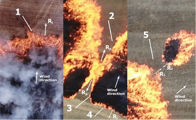
Dynamic fire behaviours (DFBs) (Werth et al. 2011; Filkov et al. 2018; Tedim et al. 2018; Filkov et al. 2020a) are often implicated in these extreme wildfire events, as the escalation in rate of spread (ROS) and intensity associated with them can lead to the development of mass fires or ‘fire storms’, resulting in tremendous burning rates and tornado-strength winds (Finney and McAllister 2011). Merging fires (Viegas 2012; Viegas et al. 2013; Thomas et al. 2017; Hilton et al. 2018; Raposo et al. 2018; Sharples et al. 2022) represent one of the key DFBs (Filkov et al. 2020a). The convergence of separate individual fires into larger fires is called coalescence, and the merging of two lines of fire intersecting at an oblique angle is termed a junction fire or junction fire fronts (also known as jump fires) (Viegas 2012). Fire coalescence and junction fire fronts are examples of merging fire fronts (Fig. 1). The dynamic behaviour of merging fires is caused by complex interactions between the flames/plumes of the individual fires (Sharples et al. 2022).
Fire types: (1) forward linear fire front (head fire); (2) forward junction fire; (3) backward junction fire; (4) backward linear fire front; (5) coalescing fires. Rl is the rate of spread of the linear fire front, Rp is the rate of spread of junction fires (rate of advance of the apex point), R1 and R2 are the rate of spread of coalescing fires. The images were extracted from drone video using VLC 3.0.20 media player (https://www.videolan.org).
Historically, the study of merging fires began with studies of liquid or gas hydrocarbon fuels by combustion science community. These studies were conducted in laboratory settings using pool fires or gas burners. Liu et al. (2013) showed that the heat feedback enhancement and air supply restriction to fuel trays are affected by the fire spacing and fire size and govern the burning rates. Wang et al. (2015) observed that burning rates and flame heights increased by 50–100% during the merging stage. With a reduction of separation distance, the flame height first declines to a lower limit before consistently increasing until the flames merge (Liu et al. 2019). However, the heat release rate (HRR), representing the flame height, increases during all stages (Liu et al. 2019). Fuel type, wind, burning intensity and slope have been found to affect the merging process. Jiao et al. (2019) showed that the fire merging criterion (tray spacing distance/tray inner diameter) depends on fuel type. Li et al. (2021) found that the radiative heat flux decays with increasing flame spacing and intensifies with increasing wind velocity. Zhou et al. (2021) found that the probability of flame merging decreases with increasing slope angle and decreasing HRR. Scale effects are also found to be important in fire interaction. The mass burning rate for small trays of liquid fuel increases monotonically as separation distance is decreased, while for larger trays it increases first and then decreases with decreasing separation distance as the process is radiation dominated (Wan et al. 2021).
Although experiments on burning liquid or gas hydrocarbon fuels provided important insights into the interaction of flames, their applicability to landscape scale wildland fire fronts is limited. In wildland fires, solid fuels are the primary source of heat energy, undergoing various stages of thermal degradation at the fire front, including drying, pyrolysis and charring. Moreover, wildland fire fronts interact in complex terrains and burn through multi-species fuels under the effect of ambient conditions (wind, temperature, humidity, etc.) that can vary over time scales of seconds to minutes (Werth et al. 2016). To overcome these challenges, the researchers continued laboratory studies of merging fires using solid fuels and varying the angle, θ, between two fire fronts (Viegas et al. 2012), slope of the fuel bed, fuel type (Viegas et al. 2013; Raposo et al. 2018), separation distance between fire fronts (Ribeiro et al. 2022) and wind conditions (Sullivan et al. 2019). A strong relationship between the velocity of the apex (i.e. the intersection point) and the angle between the fire lines for junction fires was found (Viegas et al. 2012) and two stages of junction fire development were identified (Viegas et al. 2013; Raposo et al. 2018) – an acceleration phase where the apex ROS greatly increases at the start of the fire, and a deceleration phase where the apex slows down and the fire extinguishes. In the deceleration phase the fire behaves like a linear fire front (head fire). Terrain slope has the effect of increasing the distance travelled by the apex in the acceleration phase and changes in fuel bed composition did not have a discernible effect on the ROS (Viegas et al. 2013). The ROS was found to be independent of the initial distance between the fire lines but varied non-monotonically with the wind velocity (Ribeiro et al. 2022). Sullivan et al. (2019) conducted a series of a metre scale experiments in the absence and presence of wind to study their influence on apex ROS. In contrast to findings of Viegas et al. (2012, 2013), Raposo et al. (2018), they found no significant evidence that the apex ROS increases for no-wind conditions, nonetheless noted complicated interactions between the fire lines.
Scale can also affect merging fires. In a previous study (Filkov et al. 2021), merging fire fronts were observed in field conditions, demonstrating that the fire behaviour associated with merging fires in the field can be different. It was found that the head fire front influences the shape and ROS of junction fires, in a way that is not adequately replicated in smaller scale laboratory experiments. Liu et al. (2021) also considered that the burning and spread behaviours of large-scale fires cannot be solely predicted based on laboratory scale experiments due to nonlinear effects.
Physics-based numerical modelling, i.e. computational fluid dynamics modelling that explicitly simulates combustion, can be a powerful instrument to uncover physical phenomena beyond experimental limitations. Morvan et al. (2011) studied 2D and 3D interactions between two merging fire fronts, specifically a head fire and a backfire propagating perpendicular to the wind. They observed an increase of ROS with decreasing separation distance for 2 m/s wind speed in grassland. Maynard et al. (2016) conducted a computational and experimental study of two adjacent line fires and found similar behaviour of the merging fires to wind-blown flames. Hassan et al. (2023) conducted physics-based modelling based on (Raposo et al. 2018) laboratory-scale experiments and varied junction angle as well as slope angle. Hassan et al. (2023) found that the effect of junction angle is more prominent on slopes of 30° and 45° in terms of apex ROS compared to lower and steeper slopes, and for low junction angle (≈20°), the apex ROS increases significantly for steep slopes. Using a coupled atmosphere-fire model (which does not explicitly simulate combustion), Thomas et al. (2017) tested similar junction angles θ to Viegas et al. (2012), but at a larger scale: each fire line was 1000 m long. They found that, in addition to the bulk fire-induced surface flow, sets of counter-rotating pairs of vertical vortices lying on or ahead of the fire line were formed, and these vortices produced local acceleration of fire front. While they found qualitative agreement with the results of Viegas et al. (2012), some quantitative differences in the acceleration of the apex remained. The lack of agreement could be attributed to the differences in scale and the ‘scale-gaps’ in the experimental data used to inform model development.
Understanding merging fires and validating fire behaviour models has been significantly constrained by the lack of quantitative field measurements, particularly data on the thermal and physical characteristics of interacting fire fronts. Field measurements offer the only credible foundation for assessing the accuracy of theoretical and numerical models. This critical gap in empirical knowledge has hindered innovation in modelling and predicting merging fire behaviour. In this study, we examine the hypothesis that fireline interactions during merging lead to enhanced ROS and explore how these interactions influence the thermal characteristics of fire fronts at the field scale. By providing high-quality observational data, this work aims to serve as a reference for future model development, testing and calibration. To support this, the methods and equipment used in the field experiments are first described, followed by the presentation of the results, and concluded with a discussion of the key findings and their implications.
Methods
Two experimental burns (hereafter referred to as Shelford and Lake Burrumbeet) on harvested wheat fields were conducted in Victoria, Australia, in March 12 and April 19, 2021 (Fig. 2). The terrain in both burns was relatively flat with minimal undulations. During the experiments, junction fires, spot fire coalescence and inward parallel fire fronts were investigated.
Experimental burns: (a) location of burns and an Automatic Weather Station (AWS); (b) photo of a harvested wheat field of the Shelford burn; (c) Shelford burn; and (d) Lake Burrumbeet burn. Sensor is the Davis cup anemometer and Sonic is the two-dimensional DS-2 sonic sensor. The maps a, c and d have been created using ArcGIS Pro 3.3.0 (https://esriaustralia.com.au/arcgis-pro).
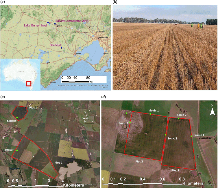
The Ballarat Aerodrome’s Automatic Weather Station (AWS) was used for air temperature and relative humidity measurements. It was located 10.6 km from the Lake Burrumbeet burn and 55 km from the Shelford burn. Due to the availability of weather observations only at 09:00 and 15:00 from the AWS, the 15:00 air temperature and relative humidity measurements were used. A Davis cup anemometer sensor in the Shelford burn (Davis Instruments Corp., USA) and two-dimensional DS-2 sonic sensors in the Lake Burrumbeet burn (Decagon Devices, Inc., USA) installed 1 m above the ground were used for local wind direction and speed measurements (Fig. 2). The wind direction and speed are calculated as 1-min averages. An EM50 datalogger (Decagon Devices, Inc., USA) was used with all sensors.
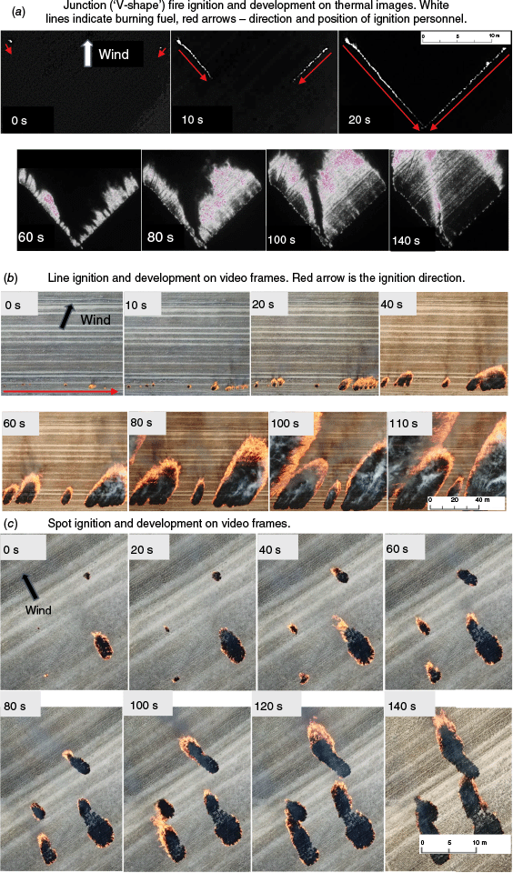
A drip torch (50% diesel fuel to 50% petrol) was used at both sites to start ignitions which were allowed to propagate downwind, in the direction in which the wind is blowing (Fig. 3). ‘V-shape’, line and spot ignitions were used in the Lake Burrumbeet burn, while only line and spot ignitions were used in the Shelford burn. Three vertices of a ‘V-shape’ fire were marked: one at the very top and two at the ends of each ignition line. Two ignition personnel then simultaneously started the ignition, starting at the ends of the lines and walking toward the apex (see Fig. 3a). The total ignition time was about 20 s. In addition to ‘V-shape’ ignition, a line ignition was used to create random junction fires and parallel fire fronts (Fig. 3b). This approach was adopted due to time constraints, allowing for the creation of multiple junction fires efficiently. It was conducted by personnel on a quad bike in one direction, mainly perpendicular to the wind. Two walking personnel conducted spot ignitions at two to four points, each 5–10 m apart (Fig. 3c). The initial junction angle and length of ‘V-shape’ at ignition ranged from 6 to 98 degrees and from 2 to 172 m, respectively. The initial length of parallel fires varied from 5 to 55 m.
Ignition protocol and fire development: (a) Junction (‘V-shape’) fire ignition and development on thermal images. White lines indicate burning fuel, red arrows - direction and position of ignition personnel; (b) Line ignition and development on video frames. Red arrow is the ignition direction; and (c) Spot ignition and development on video frames. Wind direction is consistent across all time frames.
Fuel sampling was conducted at the Shelford and Lake Burrumbeet sites just before the first experiment. A 35 cm diameter metal ring was randomly dropped three times at each site, and the fuel collected inside was used to characterise fuel height, surface-area-to-volume ratio (SAVR) and fuel load. For fuel moisture content (FMC) measurements, three random locations were selected at each site, and three subsamples of fuel were collected from each location just prior to the experiment. The samples were placed in sealed plastic bags and immediately weighed using a spring scale with 1 g accuracy (Pesola, Switzerland). On the same day, they were oven-dried at 102°C for 48 h in the lab and reweighed to calculate FMC on a dry basis. Fuel properties and weather conditions are presented in Table 1.
| Burn name | Fuel height (cm) | Fuel load (kg/m2) | SAVR (m2/m3) | FMC (%) | Wind speed (m/s) | T (°C) | RH (%) | |
|---|---|---|---|---|---|---|---|---|
| Shelford | ||||||||
| Plot 1 and 2 | 18.6 ± 3.8 | 0.03 ± 0.01 | 4222 ± 2 (411*) | 15.7 ± 2 | 3.4 ± 1.1 | 27.4 | 44 | |
| Lake Burrumbeet | ||||||||
| Plot 1 | 50.2 ± 1.9 | 0.16 ± 0.02 | 4215 ± 1 (405*) | 20.3 ± 6.7 | 5.4 ± 1.2 | 16 | 62 | |
| Plot 2 | 36.4 ± 5.8 | 0.18 ± 0.03 | 22.7 ± 1.8 | |||||
FMC is the fine fuel moisture content (dry basis), T is the air temperature at 15:00, RH is the relative humidity at 15:00, ± is the standard deviation, SAVR is the surface area to volume ratio. Surface area and volume were calculated for a hollow cylinder with a diameter of 5 mm and a wall thickness of 0.5 mm (asterisk denotes the value for a solid cylinder).
Two unmanned aerial vehicles (UAVs), a DJI Mavic Pro (Shelford burn) and DJI Matrice 210 (Lake Burrumbeet burn) were used to capture high-definition video imagery of fire propagation in synchronisation with sensor data from the on-board global positioning system (GPS) and inertial measurement unit. These sensors enabled the platform/camera orientation and position in space to be aligned with the video footage and the fire propagation georeferenced in geographical information system (GIS) software. The DJI Mavic Pro was equipped with a visual camera (3840 × 2160 pixels, 30 Hz). The camera model used with the DJI Matrice 210 was the XT2 payload with dual visual (3840 × 2160 pixels, 30 Hz) and thermal (640 × 512 pixels, 30 Hz) video capability. The thermal camera is equipped with an uncooled VOx microbolometer operating in the 7.5–13.5 µm range, allowing for the recording of truly radiometric photo (R-JPEG) and video data (SEQ). The XT2 payload allows simultaneous filming of both visual and thermal (radiometric, ≤550°C) videos.
Each drone requires use of a unique software to capture and georeference video and two different methods were used to postprocess video footage for each drone, respectively. For the DJI Mavic Pro a previously developed method was used (Filkov et al. 2021). For the DJI Matrice 210 flights were conducted through the ESRI SiteScan application (ESRI, USA). Prior to georeferencing, all flight altitudes were corrected in the metadata files following the procedure outlined in Esri 2025. The post processing phase was completed for each separate visual and thermal video and metadata file using the Full Motion Video (FMV) toolbox within the ArcGIS Pro 2.8.0 software (Macdonald 2017). The result is a video file with each frame georeferenced. The pixel size in the georeferenced frames ranged from 8.4 to 15.1 cm. The multiplexed video file was then used to identify and spatially define fire fronts at set time intervals.
To assess georeferencing accuracy, two calibration procedures were performed during a stationary drone flight under nadir conditions at an altitude of 50 m with an average wind speed of 5.5 m/s. The drone’s real-time kinematic (RTK) system provided GPS coordinates with a precision of 3 cm. The first calibration quantified inter-frame measurement error by extracting 30 distance measurements at 2‐s intervals from video frames using ArcGIS Pro, yielding a standard deviation of 1.7 cm. The second calibration evaluated the measurement error of known distances by comparing ArcGIS Pro-derived measurements with actual values, resulting in absolute georeferencing errors of 58 cm in the x-dimension and 49 cm in the y-dimension. Over the course of a 1-min stationary flight, the error remained stable, with an average drift of less than 2 cm in either dimension. Although the absolute georeferencing error was approximately 50 cm, the relative positioning between frames was maintained within 2 cm, which is critical for ensuring consistency in the ROS measurements.
After starting the ignition line, the fire front produced fire fingers. Fire fingers form when a fire line breaks up into long narrow advancing heads (Harris and McDonald 2022). When the fire lines of two neighbouring fingers naturally merged, the phenomenon was identified as a junction fire front (forward junction fire fronts, Fig. 1) and the angle between them as an initial angle. If the junction and linear fire fronts were spreading opposite to the direction of the forward linear fire front, they were identified as the backward junction and backward linear fire fronts. Two spot fires spreading toward each other were identified as coalescing fires. Two fire fronts burning parallel to each other and propagating towards each other were identified as inward parallel fire fronts. To calculate ROS of junction fire fronts (, Fig. 1), the travelling distance of the intersect point P was measured. The angle between junction fire fronts was calculated using the law of cosines θ = arccos((c2 + b2 − a2)/2bc), where a, b and с are the sides of the junction triangle (Fig. 4). The lengths of all three sides of the triangle were measured at every time step to apply this formula. To estimate the effect of merging fire fronts on fire propagation, these were compared with linear fire fronts (Fig. 1). The ROS of the linear fire front Rl was calculated by measuring the distance travelled by a point of the linear fire front in the vicinity to each merging fire front for their entire duration (, Fig. 1). The ROS of parallel and coalescence fires was measured as the ROS of their merging (, Fig. 1), where i is a time step. The time step in the measurements ranged from 2 to 5 s.
Buffer zones of forward junction and linear fire fronts. ROIs are the regions of interest. The blue and green lines, mirroring the perimeter of the fire front, define the buffer zones for each fire. θ is the junction angle, a, b and с are the sides of the junction triangle.
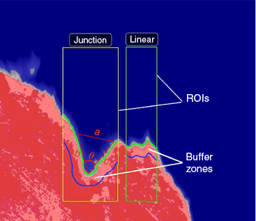
The effect of merging fire fronts on fire behaviour and thermal energy release was analysed by comparing temperatures above 250°C on thermal images of merging fires and linear fire fronts. The 250°C temperature threshold was adopted as a conservative estimate for the onset of smouldering in vegetative fuels, based on experimental observations reported by Fateev et al. (2017). This analysis was only conducted for the Lake Burrumbeet burn because only the DJI Matrice 210 was equipped with a thermal camera. Since the junction and linear fire fronts are very different in length and shape of the fire perimeter, a method was required for their relative comparison. To do this, temperatures of pixels inside the buffer zones for each fire were compared (Fig. 4).
In order to define buffer zones, linear and junction fires were first delineated and their perimeters determined on thermal images. This process is different for each type of merging fire. For junction fires, two regions of interest (ROIs) were manually created on the thermal video containing a junction fire and a section of a linear fire front (forward and backward linear fire fronts for forward and backwards junction fire fronts, respectively) using FLIR Research Studio 2.0.0. For parallel fire fronts and coalescing fires, one ROI was created containing both parallel fire fronts (their sections) and coalescing fires (complete fires). An emissivity value of 0.9 was used for temperature adjustment as a conservative estimate, based on the study by Urban et al. (2019). To avoid a flickering flame effect when identifying the edge of the fire front, a Frame Average filter with depth 15 frames (0.5 s) was used in FLIR Research Studio 2.0.0.
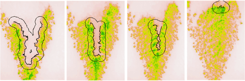
The ROIs were then exported using FLIR Research Studio 2.0.0 as bitmask images together with radiometric JPEG images containing both fires. All images were exported at 2-, 4- or 5-s intervals, starting from the formation of the merging fire to its transition to a linear fire front for junction fires (180-degree junction angle) or to the moment of joining coalescing fires. Most of the fires were measured at a 2-s interval, except for four junction fires (out of 74). Larger time intervals were selected to reduce errors in fire front detection on the video. Each JPEG image was cropped to a linear fire front or junction fire front mask within the R programming platform 4.1.0 (R Core Team 2021). Using a concave hull algorithm (Concaveman package), the length and shape of the perimeter of the junction and linear fires was determined for each JPEG image. The algorithm uses the parameter ‘concavity’ to determine how ‘tightly’ to wrap a hull to the input geometry. After an iterative process, a user defined value of 0.5 returned the best results. The ‘best result’ was determined by visually assessing the spatial conformity obtained with different values of ‘concavity’ across a subset of frames for different experiments. Values between 0.1 and 1.5 in increments of 0.1 were evaluated. Values above 0.1 and below 1 provided the best results. Because of the small variation (<5%) of results in this range, a value of 0.5 was chosen.
Using this information and the st_buffer function in R (sf package), buffer zones of relative size within the fire perimeter inside the ROI for each fire were defined for further analysis (Fig. 5). The st_buffer function takes an input geometry and specified distance, returning a buffer zone representing the area within that distance of the input geometry. Temperatures of pixels within these buffer zones were then analysed and temperature distributions were calculated for each time step. The TX2 payload comes calibrated to 550 C. When the temperature exceeds this value, the FLIR software automatically extrapolates the temperature using the factory calibration function. Since pixel temperatures were compared for similar fuels (harvested wheat crops), the extrapolated values are expected to be similar between fires and can be used for comparison.
Example of buffer zone and fire front perimeter from initiation of junction fire to linear fire front.
To analyse the pixel areas with different temperatures for all fires, the same physical scale was required. To do this, pixel areas were normalised by the mask area for each fire. Due to the different time durations of each merging fire (6–40 s), time steps were converted to percentages of the final time to enable comparison between fires.
In this study, an aggregate analysis of junction fires was used. Scatter plot analysis was utilised by combining all junction fires and presenting measurements as individual points at various time intervals, rather than tracking the dynamics of individual junction fire fronts over time. Linear and non-linear regression analyses were conducted to provide quantitative estimations. Specifically, the slope of the regression line m, R-squared, and significance value P were calculated. Response variables were the ROS of the intersection point (apex) of two junction fire fronts Rp and the angle θ between junction fire fronts. The predictor variable was time. Libraries multcomp, car and dplyr in R version 4.1.0 were used (R Core Team 2021). The 95% confidence interval for the median was calculated using the MedianCI function from the DescTools package. Negative and positive relationships were indicated as decreasing and increasing trends (slopes) respectively. Initial time was the time when two fire fingers naturally merged together. Final time for Rp was the last time when the angle between junction fire fronts became 180° (± 5°). Final time for θ was the next to the last time.
To analyse the temperature distribution of fire fronts, skewness and kurtosis statistics were used. These metrics were chosen to capture the shape and asymmetry of the temperature distributions, providing insights beyond those offered by basic summary statistics such as mean or median.
To test the hypothesis that the ROS of merging fire fronts varies across different fire scales, analysis of variance (ANOVA) was initially considered. However, preliminary checks revealed violations of key assumptions: the Shapiro–Wilk test indicated non-normality of residuals (P < 0.05), and Levene’s F test indicated non-normality of residuals. As a result, Welch’s ANOVA was applied using the oneway.test function in R. To identify which specific fire categories differed from one another, pairwise t-tests were performed using the pairwise.t.test function in R, with a correction for multiple comparisons.
Results
The use of a drone with a dual visual and thermal camera showed that the thermal camera was able to detect all active hot spots and fire fronts even through dense smoke, which was a significant limitation in our previous study when only the visual camera was used (Filkov et al. 2021). The effectiveness of thermal imaging in addressing visibility challenges due to smoke was also highlighted by Fayad et al. (2022). As a result of the experiments, 11 V-shape fires and 31 spot fires were ignited, while the remaining merging fires were initiated using line ignitions. A total of 34 videos were recorded and multiplexed.1 Seventy-four merging fire fronts (42 in Shelford and 32 in Lake Burrumbeet burn) were identified: 50 junction fire fronts (32 forward and 18 backward) and 24 coalescence fire fronts. For thermal analysis, 15 forward and 4 backward junction fire fronts, 6 coalescing fire fronts and 10 parallel fire fronts were considered since the amount of available thermal video footage was limited. The junction fire fronts identified were separated into five groups depending on the recorded initial angle between oblique fire fronts θin: 0°–15°, 15°–25°, 25°–40°, 40°–60° and 60°–90°.
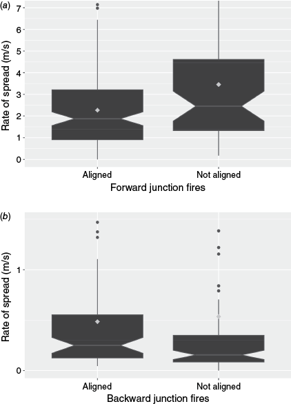
During the experiments, it was observed that the centrelines of some forward and backward junction fires were not aligned with the wind direction. Specifically, 12 out of 32 forward junction fires and 10 out of 18 backward junction fires were offset from the wind direction. To assess whether this affected the ROS, the fires were categorised into aligned and not aligned groups and comparisons were made separately for forward and backward junction fires (see Appendix Fig. A1).
Although the median ROS values differed – 1.9 and 2.5 m/s for forward junction fires, and 0.25 and 0.16 m/s for backward junction fires – the overlapping 95% confidence intervals of the medians indicated that these differences were not statistically significant. This confirms that both aligned and not aligned data can be combined for subsequent analysis.
Of the combined ROS of forward, backward and linear fire fronts, the highest median ROS was for forward junction fires (2.02 m/s), followed by head linear and backward ROS, 0.67 and 0.18 m/s, respectively (see Table 2). The ROS of the forward linear fire fronts fluctuated mostly in the range 0.1–2 m/s during the lifetime of the merging fires. A comparison of the median ROS values for forward junction fires and forward linear fire fronts between the two burns showed that the difference was very consistent. Forward junction fires were approximately 3 times faster than forward linear fire fronts, 3.02 and 3.11 times faster for the Shelford and Lake Burrumbeet burns, respectively (Table 2). The ROS of backward fire fronts is consistent between the two burns, 0.17–0.2 m/s.
| Burn | Backward ROS [CI] (m/s) | Forward ROS [CI] (m/s) | Forward linear ROS [CI] (m/s) | Forward ROS/Forward linear ROS | |
|---|---|---|---|---|---|
| Shelford | 0.17 [0.14; 0.22] 12 fires | 2.84 [2.3; 3.3] 12 fires | 0.94 [0.77; 1.01] 20 fires | 3.02 | |
| Lake Burrumbeet | 0.2 [0.15; 0.46] 6 fires | 1.37 [0.94; 1.85] 20 fires | 0.44 [0.34; 0.56] 20 fires | 3.11 | |
| Both burns | 0.18 [0.15; 0.23] 18 fires | 2.02 [1.6; 2.3] 32 fires | 0.67 [0.54; 0.8] 40 fires | 3.01 | |
| Filkov et al. (2021) | – | 1.7 | 1.08 | 1.57 |
Rate of spread (ROS) is presented as the median value, CI is the 95% confidence interval for the median [lower CI; upper CI], the number of fires represents the sample size used for calculating the medians.
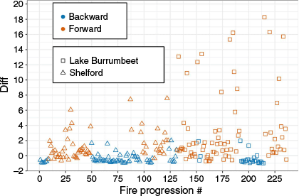
Although the average ROS of forward junction fires was 3 times that of head linear fire fronts, it was up to 18 times higher than forward linear fire fronts in some cases. To analyse this effect, the relative difference in ROS between the propagation of junction fire fronts and the forward linear fire front for each fire progression (2 or 5 s time interval) was calculated:
where Rp is the ROS of a junction fire and Rl is the ROS of a forward linear fire front.
Fig. 6 shows how much faster or slower the junction fire fronts propagate compared to linear fire fronts. The ROS of forward junction fires was generally higher (up to 18 times) than forward linear fire fronts, while backward junction fires were up to 2 times slower. The difference is also larger for Lake Burrumbeet fires.
Relative difference in rate of spread of junction fire fronts compared to forward linear fire fronts.
To identify potential trends in the data, polynomial fits up to the third order were applied to the combined dataset from both burns to analyse the evolution of ROS of forward junction fires. The highest observed R2 value was 0.27 with a corresponding P-value of 0.055, suggesting no statistically significant trend. Furthermore, no evidence in the data indicated that another function might offer a better fit. Fig. 7 shows a more conservative approach using a linear fit to examine general trends. Analysis of the evolution of the ROS of forward junction fires and the angle between them for both burns showed similar trends with other studies (Viegas et al. 2012, 2013; Sullivan et al. 2019; Hassan et al. 2023). Toward the end of merging, a deceleration of junction fires was observed, except for 0°–15° angles (Fig. 7).
Variation of the rate of spread (ROS) of the intersection point of the forward junction fire fronts: (a) θ = 0°–15°, (b) θ = 15°–25°, (c) θ = 25°–40°, (d) θ = 40°–60°, (e) θ = 60°–90°. Angles θ in the legend indicate the value at the initial time, P is the significance value. ROS at 100% time step corresponds to the last time when the angle between junction fire fronts became 180°.

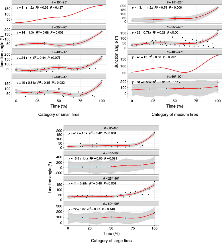
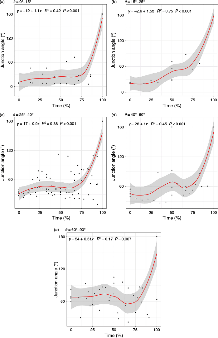
The LOESS (local polynomial regression fitting) function in R was used to analyse the evolution of junction angle because of the noticeable jump in the junction angle to approximately 180° toward the end of merging. This non-parametric method involves performing least squares regression in localised subsets and does not assume normality and independence of the data. All regressions were found to be significant (P < 0.007) with R-squared values ranging from 0.17 to 0.75. The current junction angle θ showed a consistent monotonic increase up to 75% of time at all initial angles, with a pronounced spike towards the end of merging (see Fig. 8). Notably, current angles more than doubled at the end of merging (not including the 180° time point), while the ROS did not show a significant decrease (Fig. 7).
Time evolution of the current junction angle θ for different initial junction angles, forward junction fires: (a) θ = 0°–15°, (b) θ = 15°–25°, (c) θ = 25°–40°, (d) θ = 40°–60°, (e) θ = 60°–90°. P is the significance value.
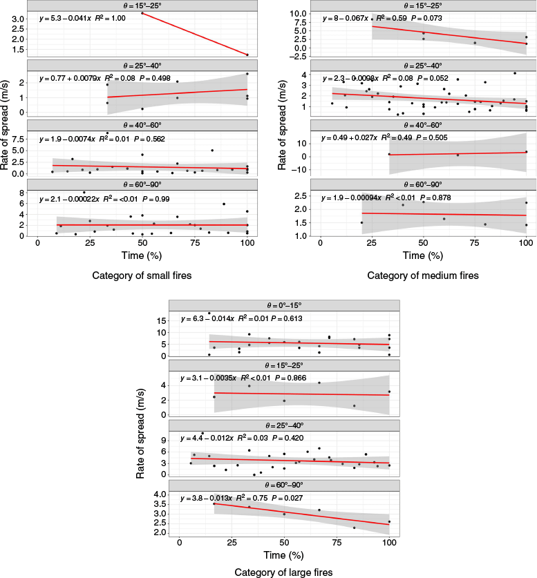
Since the initial length of the ‘V-shape’ at ignition varied from 2 to 172 m, a potential scale effect on ROS or junction angle development was considered. To examine this, all forward junction fires were grouped into three categories: small, medium, and large fires. A logarithmic binning approach (Newman 2005) in R was used to create balanced categories. The data were log-transformed and divided into three quantiles (categories). Quantile 1 ranged from 1.2 to 5.8 m, quantile 2 from 5.8 to 21.7 m, and quantile 3 from 21.7 to 86 m. These quantiles included 12, 11 and 9 fires, respectively.
A one-way ANOVA showed that the mean ROS for small (1.7 m/s), medium (1.9 m/s) and large (4.2 m/s) fires differ significantly (F = 19, numerator degrees of freedom = 2, denominator degrees of freedom = 114, P = 9 × 10⁻⁸). Further pairwise t-test analysis showed significant differences between all category pairs (P < 0.001), except between the small and medium fires pair (P = 0.4). The mean ROS data indicate that as the fire length increases from 22 to 86 m, the ROS more than doubles.
To further explore how the ROS at the intersection point and the time evolution of the current junction angle θ vary across different initial junction angles, the linear regression parameters were analysed for the fire categories (Table 3). Statistical analysis of differences between the initial junction angle groups is not presented, as the number of fires in each group was limited. Additional details are provided in Fig. A2, A3 in the Appendix.
| Initial junction angle | Small | Medium | Large | |||||||
|---|---|---|---|---|---|---|---|---|---|---|
| m | R2 | P | m | R2 | P | m | R2 | P | ||
| ROS | ||||||||||
| θ = 0–15° | – | – | – | – | – | – | −0.014 | 0.01 | 0.613 | |
| θ = 15–25° | −0.041 | 1 | – | −0.067 | 0.59 | 0.073 | −0.0035 | <0.01 | 0.866 | |
| θ = 25–40° | 0.0079 | 0.08 | 0.498 | −0.0098 | 0.08 | 0.052 | −0.012 | 0.03 | 0.42 | |
| θ = 40–60° | −0.0074 | 0.01 | 0.562 | 0.027 | 0.49 | 0.505 | – | – | – | |
| θ = 60–90° | −0.0002 | <0.01 | 0.99 | −0.0009 | <0.01 | 0.878 | −0.013 | 0.75 | 0.027 | |
| Current junction angle | ||||||||||
| θ = 0–15° | – | – | – | – | – | – | 1.1 | 0.42 | <0.001 | |
| θ = 15–25° | 1.6 | 0.96 | 0.127 | 1.5 | 0.74 | 0.006 | 1.4 | 0.69 | 0.021 | |
| θ = 25–40° | 1.3 | 0.68 | 0.002 | 0.78 | 0.28 | <0.001 | 0.88 | 0.48 | <0.001 | |
| θ = 40–60° | 1 | 0.44 | <0.001 | 1 | 0.58 | 0.237 | – | – | – | |
| θ = 60–90° | 0.54 | 0.15 | 0.032 | 0.53 | 0.31 | 0.119 | 0.6 | 0.37 | 0.149 | |
m is the slope, R2 is the coefficient of determination, and P is the significance level.
The analysis of slopes revealed that, in general, the ROS decreases more rapidly toward the end of the merging process as the size of the fire increases, regardless of the initial junction angle category. In contrast, the slopes of the current junction angles remained relatively consistent across different fire categories and irrespective of the initial junction angle.
Fig. 9 shows the pixel temperature and area distribution (i.e. the normalised pixel area of each temperature value), as well as the ROS within the buffer zones for merging and linear fires. Normalisation was performed by dividing the area of a particular temperature value by the area of the ROI (or mask) used to crop the frame for each experimental fire. This allowed for results to be comparable between experiments. These data are for the Lake Burrumbeet burn only, as the thermal imaging camera was only equipped on the DJI Matrice 210. Data analysis of regression ROS for forward junction fires showed that the forward junction ROS is consistently 1.5–2.4 times greater than the linear ROS (Fig. 9a). Although, the linear regression showed decreasing of ROS over time, overall, it was not pronounced (slope = −0.0007) and not significant (P = 0.8).
Comparison of evolution of rate of spread, temperature distribution and normalised area within the buffer zones for junction and linear fires: (a) forward junction and forward linear fires, (b) backward junction and backward linear fires. Grey area is 95% confidence interval and lines are LOESS (local polynomial regression fitting) regression lines. Time is dimensionless. Zero percent is the moment of formation of the merging fire, 100% is the moment of transition to the linear fire front (180-degree junction angle). Kurtosis, skewness, s.d., mean and max values in the legend are presented for the normalised area.
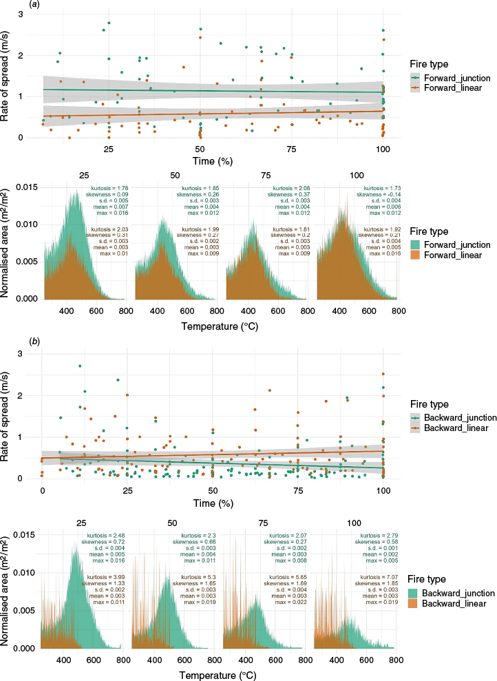
There was a difference in evolution of temperature distribution and normalised area of ‘hot’ pixels (>250°C) for forward junction and linear fires. During merging, the forward junction fires had larger area with higher temperatures (>600°C). The difference of the total normalised area between forward junction and linear fires was the biggest at the beginning, slowly decreasing till the end of merging, from 51 to 22% difference (Table 3). Overall, the total normalised area of ‘hot’ pixels of forward junction fires became smaller in the middle of merging (between 25 and 75% of time), increasing at the end. For forward linear fires, the total normalised area did not change considerably until the 100% of time, when an increase of area was observed. The total normalised area seems to correlate with the ROS for both types of fires.
In backward fires, the ROS of junction and linear fires changed differently, both in terms of value and trend (increasing or decreasing) (Fig. 9b). Initially, during the first 10% of time, the ROS showed similarities for both fire types. For backward linear fires, the ROS demonstrated relatively consistent values with a slight positive slope over time. In contrast, for backward junction fires, the ROS showed a gradual decrease, characterised by a slope of −0.0034. Notably, despite these differences, all trends were statistically insignificant with P-values greater than 0.2.
Normalised area of backward linear fires had multiple streaks which resulted from burn patchiness. Backward linear fires burnt in smaller clusters of vegetation comparative to the junction fire fronts. These clusters presented in the data as small spikes of temperature area, rather than the smoother distribution present in the normalised temperature area of backward junction fires. The total normalised area of ‘hot’ pixels of backward linear fires was always larger (except up to 25% of the time) than backward junction fires and steadily increased in contrast to backward junction fires (Table 4). At the end of merging, the difference was almost 300%. However, the majority of pixels in backward linear fires had temperatures below 500°C with equal distribution, while backward junction fires had a pronounced normal temperature distribution with a peak around 500°C, suggesting a flaming combustion, and large number of pixels in the range 500–800°C. A correlation between ROS and total ‘hot’ pixel area was also observed.
| Total normalised area vs fire type | Time | ||||
|---|---|---|---|---|---|
| 25% | 50% | 75% | 100% | ||
| Forward junction area (m2/m2) | 4.9 | 3.5 | 3.2 | 4.6 | |
| Forward linear area (m2/m2) | 2.4 | 2.1 | 2.3 | 3.6 | |
| Backward junction area (m2/m2) | 3.5 | 2.3 | 1.8 | 1.1 | |
| Backward linear area (m2/m2) | 3.1 | 3.2 | 3.5 | 3.9 | |
| Parallel fire area (m2/m2) | 6.1 | 4.6 | 5.0 | 2.2 | |
| Coalescence fire area (m2/m2) | 1.3 | 1.9 | 1.9 | 2.6 | |
Parallel fires, similar to backward junction fires, had an almost three-fold decrease in the number of high-temperature pixels by the end of the merging (Table 4, Fig. 10a). The peak of the distribution was at about 500°C for all stages. However, the ROS had an increasing trend (0.00044, P = 0.52), despite the decrease in the number of hot pixels.
Comparison of evolution of rate of spread, temperature distribution and normalised area within the buffer zones for: (a) parallel and (b) coalescent fires. Grey area is 95% confidence interval and lines are LOESS (local polynomial regression fitting) regression lines. Time is dimensionless. Zero percent is the moment of formation of the merging fire, 100% is the moment of merging of parallel or coalescence fires. Kurtosis, skewness, s.d., mean and max values in the legend are presented for the normalised area.
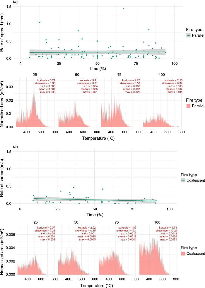
Analysis of the coalescing fires showed that although the ROS of coalescing fires decreased in time, it did not change notably (m = −0.00074) and the effect was not significant (P = 0.22) (Fig. 10). Additionally, examining the distance between fires and ROS showed a notable positive relationship: the closer the fires were to each other, the lower the observed ROS (m = 0.04, P < 0.034). However, despite the decrease in ROS, the normalised hot pixel area doubled during the merging, from 1.3 to 2.6. The temperature distribution also showed an increase in the number of high-temperature pixels toward the end of coalescence.
Skewness and kurtosis analyses were conducted on the temperature distributions in various fire scenarios. Skewness measures the asymmetry of the distribution, indicating whether the data is skewed to the left or right. A value between −0.5 and 0.5 suggests a nearly symmetrical distribution, while positive values indicate a long tail on the right and negative values indicate a long tail on the left. Kurtosis measures the combined weight of a distributions tails relative to the centre of the distribution curve. A kurtosis value of three indicates a normal distribution, while values greater than or less than three indicate distributions that are more or less outlier-prone than the normal distribution, respectively. The results indicate that for all fires, except parallel and backward linear fires, the kurtosis of the temperature distribution was around 2 and skewness in the range of −0.21 and 0.72, indicating a nearly symmetrical normal distribution. However, for backward linear fire fronts, the kurtosis and skewness were above 4 and 1.3, respectively, indicating an abnormal highly positively skewed distribution. For parallel fires, the temperature distribution was nearly normally distributed (2.6–3.4) and moderately skewed (0.3–0.7). However, at the beginning of merging (<25% time), it was highly positively skewed with a high peak and long tails (kurtosis 5.2, skewness 1.4).
Discussion
Our findings indicate that forward junction fires spread faster than linear fire fronts and this difference can be up to 18 times greater. These findings are consistent with those of (Filkov et al. 2021). However, in Filkov et al. (2021), the ratio between the forward ROS for junction fires and linear fire fronts was half that observed in the current study (Table 2). One reason for this may be the difference in weather conditions and/or fuel characteristics (Table 1). In Filkov et al. (2021), the fuel height and load were higher than in the Shelford burn but lower than those observed for the Lake Burrumbeet. Meteorological conditions, including fuel moisture content (11.9%), wind speed (1.8 m/s), and relative humidity (23%), were significantly lower compared to both burns. The air temperature (20°C) was higher than that recorded for the Lake Burrumbeet but lower than the Shelford burn.
It is interesting to note that junction fires with ROS more than eight times higher than the corresponding linear fire fronts were only observed in the Lake Burrumbeet burn (Fig. 6). One possible explanation is fuel load. Higher fuel loads tend to produce more heat and subsequently more vigorous pyroconvection.
Consistent with our earlier study (Filkov et al. 2021), similar trends were observed in the evolution of the ROS. Notably, ROS increased only for the smallest range of initial angles (0°–15°), while decreasing for angles beyond this range (Fig. 7). However, these trends were relatively weak, with slopes less than 0.007 for initial angles greater than 25° and less than 0.03 for angles falling below 25°. Interestingly, our dataset did not reveal distinct acceleration or deceleration phases in the progression of junction fires, in contrast to observations in studies of Raposo et al. (2018) and Viegas et al. (2013). It is worth noting that the absence of such phases in our data may be attributed to the relatively coarse time intervals used for analysis.
Similar to the laboratory results of Viegas et al. (2012), our experimental results demonstrate a gradual increase in the current junction angle θ over time for all initial angles, as shown in Fig. 8. Notably, this increase exhibited a consistent monotonic trend, reaching twice the initial value by the 75% time mark, with a noticeable spike observed towards the end of the merging process.
The observed decrease in the ROS and increase in junction angle are as expected. It can be assumed that at 25% of the total time, the fire propagation at the apex of the junction was faster compared to the ends of the ‘V’ shape due to the interaction between the two fire lines. Consequently, this interaction led to a larger angle and a subsequent decrease in the ROS. As the length of the fire lines decreased during merging, the junction angle consistently increased, resulting in a further decrease in the ROS towards the end of merging. Interestingly, despite the substantial increase in the current junction angle, our observations did not reveal a significant decrease in the ROS in contrast with the findings of Viegas et al. (2012) and Raposo et al. (2018). This suggests that there likely a complex interaction between fire lines, their angle and junction shoulders, which collectively influence the ROS.
Our study found that fire size influences the mean ROS of forward junction fires, with scale effects becoming evident when fires exceed 6 m in length. As fire length increased approximately fourfold, the mean ROS doubled. The significant impact of scale effects has also been demonstrated in previous studies. Previous field-scale study (<20 m fires) (Filkov et al. 2021) and the large-scale modelling study (kilometre-scale fires) by Thomas et al. (2017) both showed that the ROS of large junction fires can differ from laboratory studies. This finding was further supported by Raposo et al. (2018), who experimentally observed higher ROS in larger fires. Similarly, Liu et al. (2021), in their review, highlighted that fire spread rates in laboratory and small-scale field experiments typically range from 0.01 to 0.1 km/h, whereas large-scale wildfires often exhibit ROS between 1 and 10 km/h. They emphasised that the burning and spread behaviour of large-scale fires cannot be accurately predicted using laboratory-scale experiments alone. This is due to variations in dominant heat transfer mechanisms across different fuel dimensions, as well as the nonlinear increase in flame radiation with flame volume. Consequently, no simple scaling procedures can be directly applied to predict the burning and spread dynamics of large-scale merging fires.
Observations from Fig. 9 revealed that the linear ROS wasn’t constant throughout the duration of the forward junction fire, fluctuating by approximately 17%. Two potential explanations arise from this observation. First, the proximity of the linear fire front ROS measurements to the junction fire may have affected the ROS of the linear fire front itself. Second, the effect of wind on the ROS may also have contributed to this variability. However, the variations in linear ROS were much smaller, by an order of magnitude or more, compared to the changes in junction ROS, suggesting that these variations in linear ROS were unlikely to affect the faster ROS observed in junction fires.
Despite the similar underlying physical mechanism of coalescing and parallel fires, the different configurations of their fire fronts led to different outcomes in this study. It is noteworthy that all parallel fire fronts in our experiments were aligned with the wind direction. For parallel fires, a weak increase in ROS (slope = 0.00044) was observed, along with a significant decrease in the normalised area of ‘hot’ pixels, showing nearly a three-fold reduction (Fig. 10a). In contrast, for coalescence fires, the ROS decreased over time (m = −0.00074) and the normalised area demonstrated a stable, almost doubling increase (Fig. 10b).
In parallel fires, Ribeiro et al. (2022) observed a consistent increase in the ROS at higher wind speeds, such as 5 m/s (5.4 m/s in this study), as the separation distance between two merging fire fronts decreased. The explanation provided is that at elevated wind speeds, the heat generated by the approaching flame fronts can override the residual heat from the burnt area, resulting in intensified flow convergence between the two fire lines and subsequently increasing the ROS. However, this explanation does not fully explain the reduction observed in the normalised area.
The decrease in the ROS of coalescing fires observed in this study may potentially be attributed to the presence of a stagnant region between the two fire fronts when they are in close proximity. This stagnant region could block the inflow of oxygen, thereby reducing ROS, as suggested by Wadhwani et al. (2023). In regards to increase of normalised area, in simulations conducted by Hilton et al. (2017), an increase in fire intensity was also observed when studying the interaction of multiple spot fires.
The inverse relationship between ROS and normalised temperature area may be related to the different configuration of fire fronts. In parallel fires, fire fronts typically appear as straight lines parallel to the wind direction, whereas in coalescing fires they take on an oval shape. These different results highlight the nuanced effects of fire front configuration on fire behaviour.
The lack of information on the contribution of convection and radiation to the merging process and the difficulty of measuring them in the field, motivated us to use indirect measurements (drone with a thermal and visual camera). It was expected that a higher normalised area of ‘hot’ pixels in forward junction fires would indicate larger areas of simultaneous fuel burning, (i.e. greater flame depth), higher temperatures and a faster ROS. However, it was observed that only during the final stage of merging (at 75 and 100% time), the normalised area of pixels above 500°C, representing the flaming front as defined by (Wotton et al. 2011), increased without affecting the ROS. This is consistent with previous studies that found that the enhanced flame depth is a consequence of the forward junction fires rather than a mechanism driving their propagation. For example, Liu et al. (2021) discuss potential mechanisms of fire merging and suggested interacting air entrainment fields and enhanced heat feedback to fuels as one of the mechanisms. Incorporating indirect measurements in future studies would enable meaningful comparisons with direct physical measurements (Silvani and Morandini 2009), thereby enhancing the interpretation of fire merging dynamics.
There was a difference in evolution of temperature distribution and normalised area of ‘hot’ pixels (>250°C) for forward junction and linear fires. During merging, the forward junction fires had larger area with higher temperatures (>600°C). The difference of the total normalised area between forward junction and linear fires was the biggest at the beginning, slowly decreasing till the end of merging, from 51 to 22% difference (Table 4). Overall, the total normalised area of ‘hot’ pixels of forward junction fires became smaller in the middle of merging (between 25 and 75% of time), increasing at the end. For linear forward fires, the total normalised area did not change considerably till the end of merging (100%), when increase of area was observed. The total normalised area seems to correlate with the ROS for both types of junction fires.
Analysis of the normalised area of ‘hot’ pixels indicates that convective heat transfer plays a significant role in the merging process. Notably, during merging in forward junction fires and coalescence fires, there is an increase in the normalised area, whereas it decreases in backward junction fires and parallel fires. This phenomenon can be explained by the dominance of radiative heat transfer in backward junction and parallel fires, where the fire moves opposite and perpendicular to the wind direction, leading to a decrease in the normalised area during merging. The different behaviours observed in forward and backward junction fires, as well as parallel and coalescence fires, highlight the importance of considering the interplay between wind direction, fire movement and heat transfer mechanisms in understanding the dynamics of merging fire fronts.
The dataset presented here, which includes detailed measurements for junction fires, parallel fires and coalescence fires, offers a valuable resource for validating and testing fire behaviour models. By capturing key parameters such as progression times, ROS for different fire fronts, junction angles, fire front lengths and their alignment relative to wind direction, this dataset provides rich, quantitative insights into the complex dynamics of merging fires. Additionally, the dataset includes junction fire perimeters and pixel-level temperature information for each fire front as truly radiometric photo data (R-JPEG) and thermal video sequences (SEQ). These high-resolution thermal observations enable a detailed analysis of the fire’s thermal characteristics alongside its spatial progression. Such comprehensive data allow modellers to directly compare predicted fire spread rates, intensity and thermal patterns against measured values under a variety of merging fire scenarios, including forward and backward junction fires. Importantly, this enables the assessment of how well existing models capture both physical and thermal interactions between multiple fire fronts. Discrepancies between model outputs and observed data can help identify limitations in current modelling approaches, driving improvements and refinements. Thus, this dataset serves not only as a benchmark for model validation but also as a foundation for challenging and advancing theoretical and numerical fire behaviour models, ultimately contributing to more accurate and reliable fire prediction tools.
Limitations
Field scale experiments in this study include minor natural variations in conditions, such as different weather conditions, fuel loads, structural arrangements and ignition patterns. As a result, the reproducibility of findings may be limited. Despite the challenges inherent in conducting field experiments in fire behaviour, it is believed that the findings presented here are of significant value to wildfire science and provide valuable insights into the complex dynamics of merging fires.
In this study, air temperature and relative humidity were obtained from a single AWS data point, while wind speed and direction were measured using 1-min averages from Davis cup anemometers and 2D DS-2 sonic sensors. The low temporal resolution of air temperature and relative humidity prevented us from studying their effects on merging fires. Although wind speed and direction were measured at 1-min intervals, this resolution did not allow us to fully investigate the impact of wind variability and gustiness on merging fires. This limitation has been addressed in our current studies through the use of a portable weather station and custom-made 3D wind sensors with 1-s resolution.
The drone thermal camera is factory calibrated to 550°C, and values exceeding this limit are extrapolations in the FLIR software. Caution should be taken when quantitatively analysing values beyond this range. However, in this study, this extrapolation approach is justified as the same processing protocol was consistently applied to all fires, and pixels with temperatures above 500°C are grouped as one area. To address this, our current studies incorporate a thermal filter to extend the temperature range up to 1200°C.
Conclusion
A series of field experiments have confirmed that merging fires behave differently than regular fires (linear or head fire fronts), and standard operational models will underestimate fire behaviour when merging occurs. In some cases, the forward ROS of junction fires can be up to 18 times higher than the linear ROS. A fourfold increase in fire length of forward junction fires led to a doubling of the mean ROS, highlighting the significant influence of fire size on spread rate. Analysis of the thermal footages revealed that a greater number of pixels with higher temperatures were observed at the end of fires merging in forward junction fires compared to linear fire fronts, suggesting that after reaching some threshold area they may lead to other DFBs involving pyroconvective interactions, firebrand showers, fire whirls and other effects. These results indicate the danger that junction fires can pose to firefighters and communities, highlighting the need to incorporate the dynamic behaviour of junction fires into operational fire behaviour models. The high-quality data obtained from these experiments provide a valuable resource for future testing, validation and improvement of theoretical and numerical fire spread models, supporting enhanced prediction and management of wildfire risks.
Data availability
The datasets supporting this study are openly accessible in the Figshare repository at https://figshare.com/s/13a806dcab758f9f8dea. All files are available under a CC BY-NC 4.0 license, can be downloaded without restriction.
Conflicts of interest
Craig Clements is an Associate Editor of International Journal of Wildland Fire but was not involved in the peer review or any decision-making process for this paper. The authors have no further conflicts of interest to declare.
Declaration of funding
This study was funded by the Bushfire and Natural Hazards Cooperative Research Centre ‘Predicting merging fire behaviour in planned burning’ project and ARC Discovery Project [DP210102540] ‘Understanding the Origin and Development of Extreme and Mega Bushfires: Merging Fire Fronts’.
Declaration of use of AI
After writing the manuscript, the authors used ChatGPT in order to improve the coherence and readability. After using this tool/service, the authors reviewed and edited the content as needed and take full responsibility for the content of the publication.
Acknowledgements
We thank Elena Filkova for processing video footage, Michael Rowe for helping conduct the Lake Burrumbeet burn and James Taylor for providing access to his farmland for the experiments.
Author contributions
A. F. initiated the study and wrote the article; all authors participated in the study design; A. F. and B. C. performed the experiments; A. F. and B. H. performed the analysis; all authors contributed to the interpretations of the results and edited and approved the paper. K. M., D. S., J. S., J. H., C. C. and T. P. obtained the funds for the study.
References
Bradstock RA (2010) A biogeographic model of fire regimes in Australia: current and future implications. Global Ecology and Biogeography 19, 145-158.
| Crossref | Google Scholar |
Collins L, Clarke H, Clarke MF, McColl Gausden SC, Nolan RH, Penman T, Bradstock R (2022) Warmer and drier conditions have increased the potential for large and severe fire seasons across south‐eastern Australia. Global Ecology and Biogeography 31, 1933-1948.
| Crossref | Google Scholar |
Deloitte Access Economics (2021) Update to the economic cost of the social impact of natural disasters. Available at http://australianbusinessroundtable.com.au/our-research [accessed 25 August 2022]
Di Virgilio G, Evans JP, Blake SAP, Armstrong M, Dowdy AJ, Sharples J, McRae R (2019) Climate change increases the potential for extreme wildfires. Geophysical Research Letters 46, 8517-8526.
| Crossref | Google Scholar |
Esri (2025) Correct drone flight altitude data in Geospatial Video Log (GVL) files in ArcGIS Flight. Available at https://support.esri.com/en-us/knowledge-base/correct-drone-flight-altitude-data-in-geospatial-video--000027161
Fateev V, Agafontsev M, Volkov S, Filkov A (2017) Determination of smoldering time and thermal characteristics of firebrands under laboratory conditions. Fire Safety Journal 91, 791-799.
| Crossref | Google Scholar |
Fayad J, Rossi L, Frangieh N, Awad C, Accary G, Chatelon F-J, Morandini F, Marcelli T, Cancellieri V, Cancellieri D, Morvan D, Pieri A, Planelles G, Costantini R, Meradji S, Rossi J-L (2022) Numerical study of an experimental high-intensity prescribed fire across Corsican Genista salzmannii vegetation. Fire Safety Journal 131, 103600.
| Crossref | Google Scholar |
Filkov AI, Duff TJ, Penman TD (2018) Improving fire behaviour data obtained from wildfires. Forests 9, 81.
| Crossref | Google Scholar |
Filkov AI, Duff TJ, Penman TD (2020a) Frequency of dynamic fire behaviours in Australian forest environments. Fire 3, 1.
| Crossref | Google Scholar |
Filkov AI, Ngo T, Matthews S, Telfer S, Penman TD (2020b) Impact of Australia’s catastrophic 2019/20 bushfire season on communities and environment. Retrospective analysis and current trends. Journal of Safety Science and Resilience 1, 44-56.
| Crossref | Google Scholar |
Filkov A, Cirulis B, Penman T (2021) Quantifying merging fire behaviour phenomena using unmanned aerial vehicle technology. International Journal of Wildland Fire 30, 197-214.
| Crossref | Google Scholar |
Finney MA, McAllister SS (2011) A review of fire interactions and mass fires. Journal of Combustion 2011, 548328.
| Crossref | Google Scholar |
Ganteaume A, Barbero R, Jappiot M, Maillé E (2021) Understanding future changes to fires in southern Europe and their impacts on the wildland-urban interface. Journal of Safety Science and Resilience 2, 20-29.
| Crossref | Google Scholar |
Halofsky JE, Peterson DL, Harvey BJ (2020) Changing wildfire, changing forests: the effects of climate change on fire regimes and vegetation in the Pacific Northwest, USA. Fire Ecology 16, 4.
| Crossref | Google Scholar |
Harris SJ, McDonald NR (2022) Fingering instability in wildfire fronts. Journal of Fluid Mechanics 943, A34.
| Crossref | Google Scholar |
Hassan A, Accary G, Sutherland D, Moinuddin K (2023) Physics-based modelling of junction fires: parametric study. International Journal of Wildland Fire 32, 336-350.
| Crossref | Google Scholar |
Herring SC, Christidis N, Hoell A, Hoerling MP, Stott PA (2020) Explaining extreme events of 2018 from a climate perspective. Bulletin of the American Meteorological Society 101, S1-S140.
| Crossref | Google Scholar |
Hilton J, Sharples J, Sullivan A, Swedosh W (2017) Simulation of spot fire coalescence with dynamic feedback. In ‘22nd International Congress on Modelling and Simulation’, Hobart, Tasmania, Australia, 3–8 December 2017. pp. 1111–1117. Available at https://mssanz.org.au/modsim2017/H10/hilton2.pdf
Hilton JE, Sullivan AL, Swedosh W, Sharples J, Thomas C (2018) Incorporating convective feedback in wildfire simulations using pyrogenic potential. Environmental Modelling and Software 107, 12-24.
| Crossref | Google Scholar |
Jiao Y, Gao W, Liu N, Lei J, Xie X, Zhang L, Tu R (2019) Interpretation on fire interaction mechanisms of multiple pool fires. Proceedings of the Combustion Institute 37, 3967-3974.
| Crossref | Google Scholar |
Li B, Wan H, Ding L, Ji J (2021) Predicting radiative heat fluxes from two buoyant turbulent diffusion flames from burning propane under cross wind. Proceedings of the Combustion Institute 38, 4897-4906.
| Crossref | Google Scholar |
Liu N, Liu Q, Lozano JS, Zhang L, Deng Z, Yao B, Zhu J, Satoh K (2013) Multiple fire interactions: a further investigation by burning rate data of square fire arrays. Proceedings of the Combustion Institute 34, 2555-2564.
| Crossref | Google Scholar |
Liu N, Zhang S, Luo X, Lei J, Chen H, Xie X, Zhang L, Tu R (2019) Interaction of two parallel rectangular fires. Proceedings of the Combustion Institute 37, 3833-3841.
| Crossref | Google Scholar |
Liu N, Lei J, Gao W, Chen H, Xie X (2021) Combustion dynamics of large-scale wildfires. Proceedings of the Combustion Institute 38, 157-198.
| Crossref | Google Scholar |
Macdonald O (2017) Getting to know ArcGIS Pro. Cartographic Journal 54, 284-285.
| Crossref | Google Scholar |
Matthews S, Sullivan AL, Watson P, Williams RJ (2012) Climate change, fuel and fire behaviour in a eucalypt forest. Global Change Biology 18, 3212-3223.
| Crossref | Google Scholar | PubMed |
Maynard T, Princevac M, Weise DR (2016) A study of the flow field surrounding interacting line fires. Journal of Combustion 2016, 6927482.
| Crossref | Google Scholar |
Morvan D, Hoffman C, Rego F, Mell W (2011) Numerical simulation of the interaction between two fire fronts in grassland and shrubland. Fire Safety Journal 46, 469-479.
| Crossref | Google Scholar |
Newman MEJ (2005) Power laws, Pareto distributions and Zipf’s law. Contemporary Physics 46, 323-351.
| Crossref | Google Scholar |
Parente J, Pereira MG, Amraoui M, Fischer EM (2018) Heat waves in Portugal: current regime, changes in future climate and impacts on extreme wildfires. Science of The Total Environment 631–632, 534-549.
| Crossref | Google Scholar | PubMed |
Peterson DA, Fromm MD, McRae RHD, Campbell JR, Hyer EJ, Taha G, Camacho CP, Kablick GP, Schmidt CC, DeLand MT (2021) Australia’s Black Summer pyrocumulonimbus super outbreak reveals potential for increasingly extreme stratospheric smoke events. npj Climate and Atmospheric Science 4, 38.
| Crossref | Google Scholar |
Pinto P, Silva ÁP, Viegas DX, Almeida M, Raposo J, Ribeiro LM (2022) Influence of convectively driven flows in the course of a large fire in Portugal: the case of Pedrógão Grande. Atmosphere 13, 414.
| Crossref | Google Scholar |
Raposo JR, Viegas DX, Xie X, Almeida M, Figueiredo AR, Porto L, Sharples J (2018) Analysis of the physical processes associated with junction fires at laboratory and field scales. International Journal of Wildland Fire 27, 52-68.
| Crossref | Google Scholar |
Ribeiro C, Reis L, Raposo J, Rodrigues A, Viegas DX, Sharples J (2022) Interaction between two parallel fire fronts under different wind conditions. International Journal of Wildland Fire 31, 492-506.
| Crossref | Google Scholar |
Rossi J, Komac B, Migliorini M, Schwarze R, Sigmund Z, Awad C, Chatelon F, Goldammer J, Marcelli T, Morvan D (2020) ‘Evolving Risk of Wildfires in Europe—The Changing Nature of Wildfire Risk Calls for a Shift in Policy Focus from Suppression to Prevention.’ (UN Office for Disaster Risk Reduction: Brussels, Belgium)
Silvani X, Morandini F (2009) Fire spread experiments in the field: temperature and heat fluxes measurements. Fire Safety Journal 44, 279-285.
| Crossref | Google Scholar |
Sullivan AL, Swedosh W, Hurley RJ, Sharples JJ, Hilton JE (2019) Investigation of the effects of interactions of intersecting oblique fire lines with and without wind in a combustion wind tunnel. International Journal of Wildland Fire 28, 704-719.
| Crossref | Google Scholar |
Tedim F, Leone V, Amraoui M, Bouillon C, Coughlan RM, Delogu MG, Fernandes MP, Ferreira C, McCaffrey S, McGee KT, Parente J, Paton D, Pereira GM, Ribeiro ML, Viegas DX, Xanthopoulos G (2018) Defining extreme wildfire events: difficulties, challenges, and impacts. Fire 1, 9.
| Crossref | Google Scholar |
Thomas CM, Sharples JJ, Evans JP (2017) Modelling the dynamic behaviour of junction fires with a coupled atmosphere-fire model. International Journal of Wildland Fire 26, 331-344.
| Crossref | Google Scholar |
Urban JL, Vicariotto M, Dunn-Rankin D, Fernandez-Pello AC (2019) Temperature measurement of glowing embers with color pyrometry. Fire Technology 55, 1013-1026.
| Crossref | Google Scholar |
Viegas DX, Raposo JR, Davim DA, Rossa CG (2012) Study of the jump fire produced by the interaction of two oblique fire fronts. Part 1. Analytical model and validation with no-slope laboratory experiments. International Journal of Wildland Fire 21, 843-856.
| Crossref | Google Scholar |
Viegas DX, Raposo J, Figueiredo A (2013) Preliminary analysis of slope and fuel bed effect on jump behavior in forest fires. Procedia Engineering 62, 1032-1039.
| Crossref | Google Scholar |
Vilà-Vilardell L, Keeton WS, Thom D, Gyeltshen C, Tshering K, Gratzer G (2020) Climate change effects on wildfire hazards in the wildland-urban-interface – Blue pine forests of Bhutan. Forest Ecology and Management 461, 117927.
| Crossref | Google Scholar |
Wadhwani R, Sutherland D, Moinuddin K, Huang X (2023) Numerical simulation of two parallel merging wildfires. International Journal of Wildland Fire 32, 1726-1740.
| Crossref | Google Scholar |
Wan H, Yu L, Ji J (2021) Experimental study on mass burning rate and heat feedback mechanism of pair of unequal circular pool fires of heptane. Proceedings of the Combustion Institute 38, 4953-4961.
| Crossref | Google Scholar |
Wang C, Guo J, Ding Y, Wen J, Lu S (2015) Burning rate of merged pool fire on the hollow square tray. Journal of Hazardous Materials 290, 78-86.
| Crossref | Google Scholar | PubMed |
Werth PA, Potter BE, Clements CB, Finney MA, Goodrick SL, Alexander ME, Cruz MG, Forthofer JA, McAllister SS (2011) Synthesis of knowledge of extreme fire behavior: Vol. I for fire management. General Technical Report PNW-GTR-854. (US Department of Agriculture, Forest Service, Pacific Northwest Research Station: Portland, OR)
Werth PA, Potter BE, Alexander ME, Clements CB, Cruz MG, Finney MA, Forthofer JM, Goodrick SL, Hoffman C, Jolly WM, McAllister SS, Ottmar RD, Parsons RA (2016) Synthesis of knowledge of extreme fire behavior: Vol. 2 for fire behavior specialists, researchers, and meteorologists. General Technical Report PNW-GTR-891. p. 258. (U.S. Department of Agriculture, Forest Service, Pacific Northwest Research Station)
Wotton BM, Gould JS, McCaw WL, Cheney NP, Taylor SW, Wotton BM, Gould JS, McCaw WL, Cheney NP, Taylor SW (2011) Flame temperature and residence time of fires in dry eucalypt forest. International Journal of Wildland Fire 21, 270-281.
| Crossref | Google Scholar |
Zhou K, Zhang L, Huang M, Zhou M, Wang C (2021) Experimental study on flame interaction and geometrical features of two identical fires on a slope. Fire Safety Journal 126, 103463.
| Crossref | Google Scholar |
Appendix
A variation in the rate of spread of forward (a) and backward (b) junction fires depending on whether or not their centreline is aligned with the wind direction or not. Mean values are represented by diamonds, while median values are shown as lines. Overlapping box plot notches indicate that the two data sets are not significantly different.
A variation of the rate of spread (ROS) of the intersection point of the small, medium and large forward junction fire fronts. Angles θ in the legend indicate the value at the initial time, P is the significance value. ROS at 100% time step corresponds to the last time when the angle between junction fire fronts became 180°.