

Contemporary fire regimes and elephant impacts in Baikiaea-dominated woodlands of the Chobe region, northern Botswana
Othusitse Lekoko A B * , Jeremy Russell-Smith B , Andrew Edwards B and Cameron Yates BA
B
Abstract
Savanna ecosystems constitute approximately 20% of the Earth’s terrestrial surface and are increasingly under threat from various factors including effects of climate change. In Baikiaea plurijuga-dominated woodlands of Botswana, the combination of destructive fire regimes and large elephant populations has been cited as a major cause of adverse vegetation changes in African savanna and woodland systems.
We assessed the status of fire regimes in Botswana’s premium wildlife eco-tourism Chobe region to determine whether market-based fire management could be applied to support broader ecological fire management and employment outcomes.
The methods used were: (1) reconstructed fire regimes from the early 1990s coinciding with the cessation of commercial timber exploitation; (2) combined automated MODIS 250 m and manually derived Landsat 30 m burn scar products to generate a 33-year Fire Frequency Index (FFI); (3) classified regional vegetation structural types derived from a 5-year (2021–2024) early dry season Landsat median image; and (4) assessed dry season elephant population density distributions in relation to fire occurrence.
Frequent (on average, one in every 2.5 years) and relatively severe late dry season fires were characteristic in more open-canopied legume-dominated savannas and grasslands in the eastern sector of the project area. Elephant distributions in the dry season were independent of fire occurrence. Wildfires plausibly cause relatively greater impacts to Baikiaea-dominated vegetation macro-structure than elephants.
Multiple factors including national fire exclusion policy contribute to contemporary fire patterning in the Chobe regional landscape.
We suggest that carbon market-based approaches have potential for contributing to ecologically sustainable fire management and local employment opportunities.
Keywords: Baikiaea plurijuga, carbon markets, Chobe, elephant impacts, fire management, forest management, Miombo, savanna, wildlife conservation.
Introduction
Savanna ecosystems constitute approximately 20% of the Earth’s terrestrial surface and play a vital role in the functioning of global terrestrial ecosystems (Sankaran et al. 2005). Globally, these are the most fire prone ecosystems with the largest portion found in Africa accounting for 60–70% of global fire extent (Roteta et al. 2019; Ramo et al. 2021; Russell-Smith et al. 2021). Emissions from fires contribute as much as 29% of global greenhouse gas (GHG) emissions (van der Werf et al. 2017). It is estimated that savannas store about 15% of the total carbon contained in the world’s vegetation and soil organic matter, compared with 25% storage by tropical forests, while each account for about 30% of terrestrial net primary productivity; the deficit in carbon storage in savannas is transformed into atmospheric carbon during fire events (Grace et al. 2006).
Anthropogenic activities are considered to be the main driver of savanna fires in southern Africa with burning primarily undertaken for a variety of livelihood activities including agricultural, pastoral, and customary land management (Archibald et al. 2010). With increasing human population densities, land use intensification and fragmentation, it is predicted to result in decreased fire extent (Andela et al. 2017); conversely, fire ignitions are expected to increase, and projected climate change is expected to create fire regimes increasingly capable of modifying savanna landscapes (Keeley and Rundel 2005).
Recurrent fire is a key modifying agent determining the structure, function, dynamics, and conservation of African savanna ecosystems, including relatively fire-prone and vulnerable leguminous tree-dominated Miombo and related woodlands, which occur across large swathes of southern Africa on infertile sandy soils (Frost 1996; Ribeiro et al. 2020a). We focus our study in Baikiaea plurijuga-dominated woodlands at the southern extent of Miombo distribution, under low rainfall conditions (~600 mm mean annual rainfall [MAR]) in the Chobe District, north-eastern Botswana. Previous fire-related studies have either reported relatively low frequencies of fire in the Chobe region, attributed to Botswana’s effective fire management exclusion policies (Pricope and Binford 2012); conversely, Dube (2013) and Cassidy et al. (2022) and argue that across northern Botswana fires typically burn out of control due to lack of resources, remoteness, limited coordination and management capacity. The combination of destructive fire regimes and large elephant populations has long been cited as a major cause of adverse vegetation changes in African savanna and Miombo woodland systems (e.g. Beuchner and Dawkins 1961; Laws 1970; Thomson 1975; Desanker et al. 1997; Mapaure and Campbell 2002; Holdo 2007; Ribeiro et al. 2008). However in the Chobe region, Ben-Shahar (1993, 1996a) and Fox et al. (2017) conclude that significant recent wooded vegetation cover change on Kalahari sands is attributable more to contemporary fire regimes than elephant impacts.
This study provides context for a broader assessment of the impacts of contemporary fire regimes on woody biomass and soil carbon stocks, and explores potential market-based management solutions in fire-prone southern African Miombo and related woodland types. We focus our study in Botswana’s ~21,000-km2 Chobe District covering over the >30-year period following cessation of forest harvesting activities in the early 1990s (Kgathi and Sekhwela 2012) as addressed in subsequent papers, specifically from 1991 when an extensive systematic forest inventory incorporating permanent geo-referenced plots was established to provide a detailed quantitative baseline (Norwegian Forestry Society 1991, The Chobe Forest Inventory Project. unpubl. data). During this era, contemporary land management regimes came into effect, with relocation of communities to permanent settlements, cessation of commercial timber harvesting, enforcement of the land use/land tenure systems, and rapidly increasing elephant populations (Child 1968).
Materials and methods
Study area
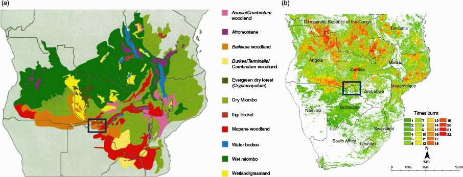
Broadly defined, Miombo and related woodlands, including those dominated by Baikiaea plurijuga (Zambezi teak) are included within southern Africa’s Miombo Ecoregion (Timberlake and Chidumayo 2011; Fig. 1a), occurring on typically infertile, acidic, freely draining sandy soils of the ancient African Plateau, under markedly southern hemisphere summer seasonal (November–April) rainfall conditions ranging generally between 600 and 1600 mm MAR. Woodlands dominated by Baikiaea plurijuga extend over 2000 km2 under low rainfall conditions in the southern portion of the Miombo ecoregion, with large tracts in Angola, Zambia, Namibia, Zimbabwe, and Botswana (Werger and Coetzee 1978; White 1983; Timberlake et al. 2010; Dziba et al. 2020). Although Baikiaea woodlands are characterised by the dominance of B. plurijuga, they are observed to integrate with other structural types including typical Miombo taxa (e.g. Russell-Smith et al. 2024). Various dominant leguminous taxa (e.g. slow growing Baikiaea, which is characteristic Miombo woodland taxa as well as Brachystegia spp., Julbernardia spp., Pterocarpus spp.), are recognised as being vulnerable to repeated severe fires, leading to shifts in species composition, conversion of wooded forests to open-savannas, and disruption to critical habitats (e.g. Frost 1996; Holdo 2007; Ribeiro et al. 2020b). Mean annual (2001–2019) savanna fire extent across this vast geography ranges between ~20% and 30% under northern higher rainfall conditions, to between 7% and 10% in the lower rainfall south (Fig. 1b); the great majority of fire extent occurs later in the 6–7 month Southern Hemisphere dry season under relatively severe fire-weather conditions (Russell-Smith et al. 2024).
(a) Distribution of Miombo sub-formations where the dominant structure is classified as dry deciduous forest and wooded grasslands (Timberlake and Chidumayo 2011) and (b) southern African fire frequency context, 2001–2022, based on a MODIS burned area product (Russell-Smith et al. 2024). The black square outlines the location of the Chobe study area.
The Chobe District is recognised globally for its rich biodiversity and high conservation value, centrally located within the multi-national Kavango-Zambezi (KAZA) conservation area (shared between Botswana, Angola, Namibia, Zambia, Zimbabwe). The KAZA area supports a thriving conservation-based economy with an estimated population of 1.5 million inhabitants (Cumming D.H. 2008, unpubl. data; Stoldt et al. 2020) and over 250,000 elephants, 600 bird species, 128 reptile species, 50 amphibian species, and diverse invertebrate species (Bussière and Potgieter 2023). The Chobe region supports the largest population of African elephants (Loxodonta africana) in the world, hosting ∼131,000 resident elephants while serving as a key migration and dispersal corridor (D. H. Cumming 2008, unpubl. data; Government of Botswana 2021). While Chobe region supports about 80% of Botswana Community-based Natural Resource Management (CBNRM) income (Chevallier 2016), KAZA has recorded the highest rate of forest cover decline since 1990 (FAO 2020)
The Chobe region lies on a flat to gently undulating landscape in the north-eastern portion of Botswana (17°–19°S, 24°–26°E). The climate is semi-arid to sub-humid, with MAR ~650 mm and >90% falling from October to the end of April; with most rain typically recorded in December and January (Skarpe et al. 2014a). This annual cycle results in seasonal accumulation of biomass followed by significant potential for regular and uncontrolled large annual fires.
The Chobe District includes portions of the Okavango and Zambezi basins (Skarpe et al. 2014a). The physical landscape is a result of paleo-environmental alluvial and aeolian regimes influenced by tectonic events (Shaw and Thomas 1993; Skarpe and Ringrose 2014) giving rise to a matrix of vegetation structures that serve both as a resource for wildlife and anthropogenic socio-economic activities. Deep aeolian and alluvial deposits form sands and silts that occupy most of the district with more fertile clay soils formed from lacustrine deposits (Barnes 2001; Smith et al. 2005). The relatively fertile clay soils formed from exposure of Stormberg basalts in the eastern part of the district are suitable and exploited for arable agriculture (Ecosurv 2018) and for pasture grasslands (Fig. 2). Low-lying seasonal drainage pans with finer particles of clay and organic material, usually colonised by elephant-truncated mopane (Colophospermum mopane) shrubs, comprise a general feature of these relatively fertile landforms.
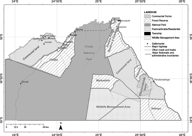
Map of Chobe District (21,000 km2) showing the project area outline, land use, firebreaks, major highway (A33), roads and tracks. Major firebreaks (graded to 20 m) primarily constitute land use boundaries.
Chobe vegetation closely follows soil formations and varies from Zambezian broad-leaved dry deciduous forests and shrubby woodland Miombo formations on deep nutrient-poor sands dominated by B. plurijuga (Zambezi teak), Pterocarpus angolensis (Africa teak), Combretum spp. (bushwillow), Schinziophyton rautanenii (mongongo), with mopane woodlands and grasslands confined to relatively fertile seasonally waterlogged clays (Skarpe et al. 2014a). Fragments of riparian vegetation, which in the 1960s used to be continuous (Child 1968; Mosugelo et al. 2002), are found along the northern fringes of the District on the Chobe-Zambezi and Linyanti river systems. The south-western portion of the district features a mosaic of mopane, acacia-dominated and grassland systems (Skarpe et al. 2014a; Fox et al. 2017; Ecosurv 2018)
Land use plays a key role in the management of the Chobe landscape. Forest Reserves are a significant land use type designated regardless of vegetation structure or characteristics, both on state and tribal lands (Government of Botswana 2011). Six Forest Reserves were established from the late 1960s to protect significant tracts of woodlands containing several high value timber species (including B. plurijuga and P. angolensis) with large tracts of oil-producing S. rautanenii forests. Logging took place from 1935 but after determining that harvesting practices were non-sustainable (Wegge 1992; Kgathi and Sekhwela 2012), timber extraction activities ceased in 1994.
The Chobe District is a home to ~28,500 inhabitants (Statistics Botswana 2022) with settlements on the outer fringes of the District. Kasane and Kazungula townships are more urbanised and form a contiguous northern urban area with a combined population concentration of 62% of the district total. The majority of settlements in the District have populations of less than 1000 people (Ecosurv 2018), rendering average district density of 1.4 persons km−2 (Statistics Botswana 2022).
We undertook fire scar mapping based on 33 years (2001–2023) of MODIS imagery at 250 m resolution; https://data.ceda.ac.uk/neodc/esacci, and multiple years of Landsat 30 m resolution imagery (https://earthexplorer.usgs.gov/) from 1991−2000 to 2003–2023. Fire scar mapping from Landsat imagery of 1995, 1998, 1999, and 2000 was omitted due to significant missing scene coverage in those years. Given this discontinuous and incomplete fire mapping record, the documented fire history record is referred to here as a Fire Frequency Index (FFI). We created a fire scar mosaic derived from the Landsat 30 m product and confined our assessment to burn scars that were at least 10 ha in size to reduce clutter caused by ‘salt & pepper’ classification artefacts created during Landsat processing. We used image differencing and density slicing techniques described in Evans and Russell-Smith (2019), and merged mapped areas to produce an annual burned area mosaic. Limitations with Landsat imagery were cloud cover and poor scene spatial co-registration especially in the earlier years.
We extracted burned area from the MOD09GQ Collection 6 BA automated daily product based on the red and near infra-red (NIR) bands of the MODIS sensor at 250 m resolution (Pettinari et al. 2021). We re-sampled MODIS 250 m imagery to 30 m resolution to match the Landsat resolution and collated the outputs to produce a 33-year Fire Frequency Index (FFI) describing the number of times each pixel burned. To assess seasonal fire dynamics, we partitioned yearly BA into the early dry season (EDS) period from January to July, and the late dry season (LDS) from August to December, following (Pellegrini et al. 2017) and other regional studies (Humphrey et al. 2021; Eames et al. 2023; Russell-Smith et al. 2024). Spatial patterning of fire from 1991 to 2023 was analysed with respect to vegetation structural types, soil condition, anthropogenic infrastructure, land use, and elephant distribution.
Vegetation fuel types (VFTs), which describe combinations of common ground fuel components and vegetation structural characteristics (Lynch et al. 2015), were derived from a supervised classification of a 5-year Landsat median of Landsat 8 and 9 images acquired during 15–30 April 2021–2024. The median image took advantage of temporal aggregation benefits derived from time series images (Phan et al. 2020), as opposed to use of images from one dry season period, given significant spectral heterogeneity driven by high inter-annual variability in rainfall, soil, geomorphology, herbivory, fire history, and anthropogenic disturbance conditions (Coughenour and Ellis 1993; Phan et al. 2020). Timing of green up and leaf fall is highly variable in this savanna (Fox et al. 2017) and therefore imagery was acquired during the grass senescence phase (April) to enhance the spectral differentiation between herbaceous and woody vegetation, thereby improving classification accuracy.
We classified the median image using the Random Forest (RF) machine learning algorithm in Google Earth Engine 2024. The RF classifier is an ensemble classification algorithm capable of handling data with high spatial auto-correlation by reducing over-fitting (Breiman 2001; Rodriguez-Galiano et al. 2012), suitable in this context where it was difficult to distribute data points evenly across the study area. We used seven bands of Landsat 8 [b2…b7, b10], NDVI, and NBR for the classification properties with 100 trees. The validation and assessment points (n = 1638) were collected in May 2024, with a helicopter operated at 60 knots (111 km h–1) and 100 feet (30.5 m) above ground level, by observers on each side of the aircraft (Edwards et al. 2001), and additional vehicle-based transects. Field data canopy cover (C) described whether observed vegetation in ~50 m × 50 m samples directly below helicopter-based observers, and immediately beyond disturbed road verges was forest (F) (F–C, > 60%), woodland (W) (W–C, 30–60%), open woodland (OW) (O –C, 10–30%), shrubland (S) (S–tree, C < 10%; shrub C > 10%), grassland (G) (G–tree and shrub, C < 10%), or bare (B) (Lynch et al. 2015). Vehicle transects followed access roads/tracks with a sample point collected every 1 km; helicopter samples were collected every 15–20 s. Representative geo-tagged photos were collected during both aerial and ground-based assessment ensuring that all major vegetation types were represented.
State and tribal lands are the main land tenure systems in the Chobe District. About 80% of the total area in Chobe District is designated as Protected Areas, including 10% of Wildlife Management Area (WMA) (van der Sluis et al. 2017; Ecosurv 2018). The remaining 20% is utilised for communal arable and pastoral activities. We adopted and modified land use planning zones from the Chobe District Integrated Land use Plan of 2017 (van der Sluis et al. 2017) to partition our project area into ecologically functional zones here referred to as ecozones. The zones were established to provide a spatial assessment framework, and for sustainable planning and management protocols (van der Sluis et al. 2017). We restricted our study to the ecozones within the Miombo ecosystem suitable for incentivised savanna burning carbon emissions abatement and sequestration methodologies (Lipsett-Moore et al. 2018). Ecozones coinciding with Forest Reserves serve as major forest conservation areas with community resource access and tourism. Ecozones within Chobe NP serve primarily as wildlife conservation areas and tourism. Undesignated areas are reserved for communal multi-use and tourism.
The Chobe region is home to Africa’s largest elephant population with an estimated ∼131,000 individuals in 2018 (Chase et al. 2018). Elephants have contributed to reported decline of woodland structure by killing smaller mature trees or damaging them sufficiently to expose them to fire damage and attack by insects and fungus (Thomson 1975; Mmolotsi et al. 2012; Skarpe et al. 2014a). We compiled available dry season elephant distributions from census data provided by the Department of Wildlife and National Parks (DWNP) for the years 1994, 1999, 2003, and 2012 to assess potential spatial relationships between elephants, fire, and vegetation fuel types.
Results
Burned area mapping
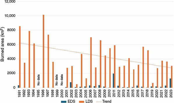
Available annual fire mapping data for the period 1991–2023 imply an apparent decline in burnt area (BA) over the study period, with the great majority of detected fire scars occurring in the LDS period (Fig. 3). During 2001–2023 when both sufficient Landsat and MODIS imagery were available, mean BA was 329 km2 in the EDS and 3707 km2 in the LDS, representing 8% and 92% of the study area, respectively. Over the 33-year study period, the spatial patterning of BA occurred mostly in the eastern sector of the study area (Fig. 4a), including in both EDS and LDS periods during 2001–2023 assessed using available MODIS imagery (Fig. 4b, c).
Burnt Area (BA) mapping for the 21,000-km2 study area derived from available imagery sources for the period 1991–2023 (note: insufficient imagery for years 1995,1999, and 2000). BA mapping for EDS (pre-August) and LDS periods included where sufficient with seasonal imagery available (note: insufficient Landsat coverage 1992–1998). Trend line represents apparent decline in annual BA extent over the study period.
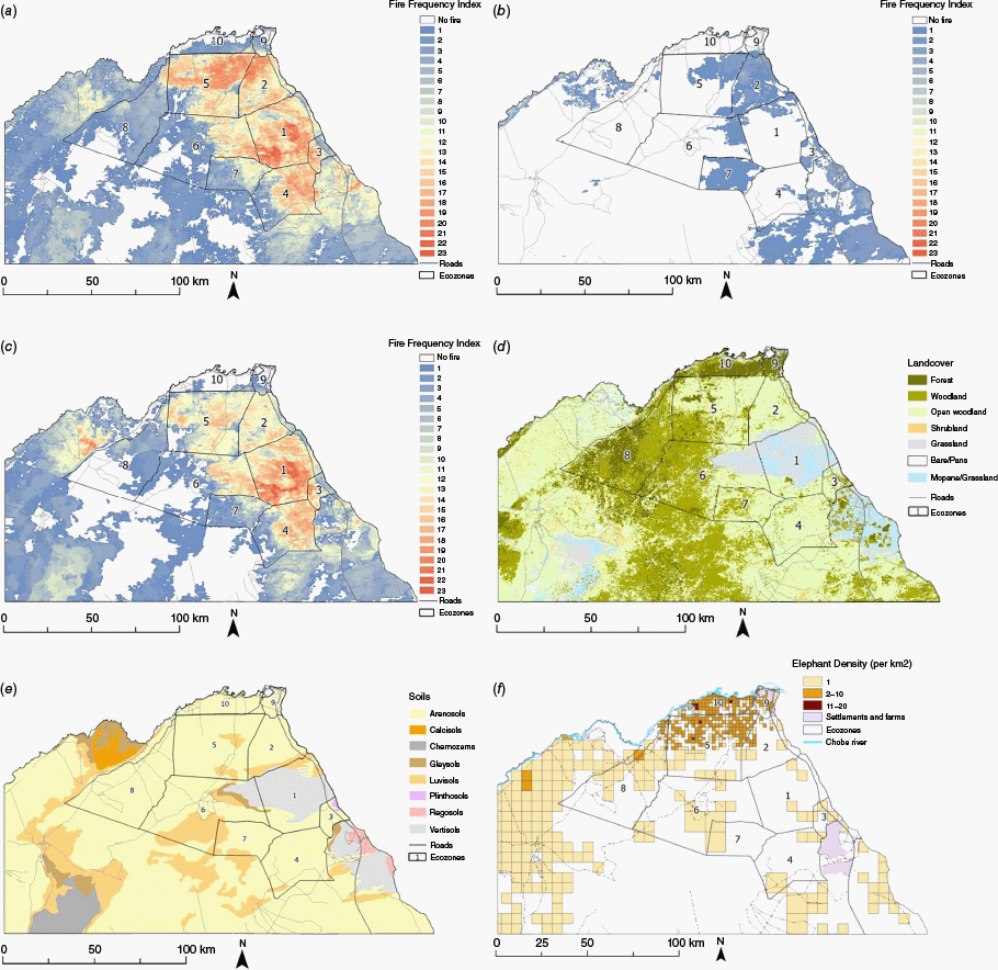
(a) Fire Frequency Index (FFI) based on burnt area (BA) over a 33-year (1991–2023) period combining available MODIS and Landsat BA products, FFI in (b) EDS, and (c) LDS periods based on BA mapping derived from MODIS imagery 2001–2023. (d) Landcover vegetation structural types, (e) soils distribution (Department of Surveys and Mapping, Botswana), and (f) dry season average elephant distribution (1994, 1999, 2003, and 2012. Note: different sample scales; Department of Wildlife and National Parks, Botswana). Ecozones 1–10 on all maps are proposed management units adapted from the Chobe District Land use Plan (van der Sluis et al. 2017). See Table 1 for Ecozone names.
Landcover vegetation types
Overall, landcover vegetation structural type mapping indicated that the study area comprised 7.6% forest, 26.6% woodland, 49.3% open woodland, 3% shrubland, 6% grassland, 1.3% bare, and 6.3% mixed mopane and grassland. Based on extensive validation data (see Materials and methods), mapping accuracy overall was determined to be 85%, with reliability >90% for open woodland, grassland, and forest types; and 78% for woodland (overlapping both forest and open woodland; Table 1). Forest vegetation was observed to occur in the north of the study area, woodland predominantly in the west, and open woodland and grassland in the east (Table 2; Fig. 4d). Baikiaea forest, associated Miombo woodland and open woodland types, all occurred on deep sandy Arenosols, with grassland and accompanying mopane types on clay-dominated vertisols (Fig. 4e).
| Ecozone rank | Ecozone | ID | Landuse | Area (km2) | Average FFI | Landcover vegetation type (%) | ||||||||
|---|---|---|---|---|---|---|---|---|---|---|---|---|---|---|
| EDS | LDS | F | W | OW | S | G | B | G/M | ||||||
| 1 | Kakulwane Plains | CH/5 | Communal | 1231.6 | 0.2 | 12.9 | 0.7 | 1.5 | 21.1 | 0.9 | 42.5 | 0.0 | 33.3 | |
| 2 | Kasane Forest Extension | CH/4(2) | Forest Reserve | 697.4 | 1.4 | 9.6 | 0.5 | 6.1 | 83.3 | 1.1 | 6.6 | 0.1 | 2.2 | |
| 3 | Kazuma Forest Reserve | CH/6 | Forest Reserve | 190.1 | 0.6 | 9.0 | 6.3 | 16.4 | 66.9 | 1.7 | 2.0 | 0.1 | 6.6 | |
| 4 | Chobe East | CH/8 | Communal | 955.9 | 0.1 | 8.8 | 0.3 | 7.1 | 88.2 | 2.9 | 0.2 | 0.0 | 1.1 | |
| 5 | Chobe National Park – Maku | CH/3(2) | National Park | 1506.5 | 0.3 | 8.3 | 8.0 | 27.9 | 60.8 | 3.0 | 0.1 | 0.0 | 0.1 | |
| 6 | Chobe National Park – Nogatsaa | CH/3(1) | National Park | 1810.8 | 0.1 | 3.8 | 5.4 | 44.9 | 31.6 | 1.6 | 12.1 | 0.4 | 3.9 | |
| 7 | Maikaelelo Forest Reserve | CH/7 | Forest Reserve | 570.5 | 0.8 | 3.5 | 0.2 | 27.3 | 69.9 | 1.8 | 0.0 | 0.0 | 0.8 | |
| 8 | Chobe Forest Reserve | CH/2 | Forest Reserve | 1451.9 | 0.0 | 1.5 | 32.8 | 52.9 | 13.5 | 0.8 | 0.0 | 0.1 | 0.0 | |
| 9 | Kasane Forest Reserve | CH/4(1) | Forest Reserve | 153.4 | 0.2 | 1.1 | 65.1 | 13.1 | 15.8 | 0.5 | 1.4 | 2.3 | 1.8 | |
| 10 | Chobe National Park – Waterfront | CH/3(3) | National Park | 446.5 | 0.0 | 0.5 | 57.2 | 25.4 | 13.7 | 0.7 | 0.4 | 1.6 | 1.0 | |
Landcover vegetation type illustrates the proportion of each vegetation structure in each ecozone, demonstrating significance of vegetation structure to fire frequency.
F, forest; W, woodland; OW, open woodland; S, shrubland; G, grassland; B, bare; G/M, grassland/mopane.
| Image | Accuracy (%) | Field data | ||||||||
|---|---|---|---|---|---|---|---|---|---|---|
| F | W | OW | S | G | B | G/M | Total | |||
| Forest | 89.8 | 185 | 19 | 2 | 0 | 0 | 0 | 0 | 206 | |
| Woodland | 78.2 | 20 | 226 | 43 | 0 | 0 | 0 | 0 | 289 | |
| Open woodland | 94.5 | 4 | 19 | 479 | 4 | 0 | 0 | 1 | 507 | |
| Shrubland | 56.6 | 3 | 8 | 58 | 90 | 0 | 0 | 0 | 159 | |
| Grassland | 92.9 | 0 | 0 | 3 | 0 | 143 | 0 | 8 | 154 | |
| Bare | 40 | 0 | 0 | 3 | 0 | 0 | 2 | 0 | 5 | |
| Grassland/mopane | 82.6 | 0 | 1 | 5 | 0 | 13 | 0 | 90 | 109 | |
| Total accuracy = 85% | ||||||||||
| Kappa = 0.805 | 212 | 273 | 593 | 94 | 156 | 2 | 99 | 1429 | ||
Numbers given in bold indicate % agreement.
F, forest; W, woodland; OW, open woodland; S, shrubland; G, grassland; B, bare; G/M, grassland/mopane.
Over the 33-year study period, annual fire extent was greatest in grassland and in mixed grassland/mopane (mean FFI = 10 and 11, respectively, which is equivalent to one fire every 3 years), followed by open woodland and shrubland (mean FFI = 5 and 6, respectively, which is equivalent to one fire every 5 and 6 years). Woodland and forest showed the lowest annual fire extent (FFI = 3 each, which is equivalent to one fire every 10 years).
Land use
We ranked the ecozones by fire prevalence from 1 (highest fire prevalence) to 10 (lowest fire prevalence). Fire prevalence was associated generally across communal and public lands, consistently in the LDS period. Rather, most fire (FFI >12) occurred annually across land use types in the central and eastern sectors of the study area, and least (FFI <3) in the extreme north and western sector public lands (Table 1; Fig. 4a).
Elephant distribution
The mean dry season elephant density distribution derived from 4 years of available records is in Fig. 4f. Highest dry season densities are observed in northern portions of the study area (particularly in proximity to perennial water resources associated with the Chobe River wetlands), and are associated generally with forest, woodland, and open woodland vegetation types (Fig. 4d), and highly variable fire occurrence conditions (Fig. 4a).
Discussion
Contemporary fire regimes in the Chobe District are characterised by two contrasting patterns: (1) over the majority of the region, annually extensive anthropogenic fires occur predominantly in the LDS under relatively severe hot, dry, and low humidity fire-weather conditions; and (2) restricted burning mostly in the south-west and along northern river-frontages is predominantly associated with conservation and tourism management. The incidence of frequent wildfires is representative of much of fire-prone northern Botswana (Cassidy et al. 2022), and regional Miombo and related woodland systems generally across southern Africa (Russell-Smith et al. 2021; Russell-Smith et al. 2024). It is widely observed that fire regimes dominated by relatively intense fires have significant destructive impacts on regional woodland systems, especially under more xeric conditions typical of northern Botswana (e.g. Trapnell 1959; Frost 1996; Chidumayo 1997; Holdo 2005, 2006; Fox et al. 2017; Ribeiro et al. 2020a; Cassidy et al. 2022). Implementing more ecologically sustainable fire management in the Chobe region, including maintenance of productive grassland systems for diverse herbivore assemblages, presents critical challenges given globally significant wildlife conservation and habitat management requirements, and associated regional tourism industry economic values.
Historical land use context
Historical records of landscape-scale fire patterning in the study area are scant but presumably involved the widespread application of fire especially by San communities for hunting and gathering, and controlling fire spread through detailed knowledge of ecological requirements and seasonal conditions (Archibald et al. 2012). The 1870s saw the arrival of pastoral settlers who burned virtually every year in the LDS to promote growth of palatable grass species at the expense of woody biomass (Child 1968; Skarpe et al. 2014a). This practice continued through the turn of the century and was followed by commercial timber harvesting from 1935, virtually throughout north-eastern sectors in areas with harvestable timber material (Child 1968; Kgathi and Sekhwela 2012). In 1938, EDS burning was introduced and adopted as the official fire policy of the Forestry Department, confronting the prevailing LDS burning practices of local pastoralists and the concerns of wildlife managers (Child 1968).
Formal moves towards establishment of Chobe National Park in 1967 commenced in the early 1960s, and regional Forest Reserves from the late 1960s. These developments coincided with the relocation of original inhabitants from parts of the Chobe District interior and government enforcement of fire exclusion, suppressing cultural fire practices. In the mid-1980s, Botswana introduced its National Fire Management Policy, which emphasised fire exclusion particularly in Protected Areas like National Parks and Forest Reserves. In the 1990s, these fire exclusion and suppression policies were augmented by implementation of a widespread system of linear graded firebreaks of width ranging from 10 m to 20 m depending on assumed protection priority, including within Protected Areas (Fig. 2). The most recent iteration of Botswana’s fire management legislated framework, the Forest Act of 2007, although allowing for the undertaking of control burns under Permit conditions, essentially reaffirmed the fire exclusion policy.
The trajectory of fire exclusion practice in Botswana follows many other former colonial and subsequent neo-colonial governments in restricting or banning use of fire, including by Indigenous peoples dependent on long-standing traditional fire management practices with claimed ecological and forestry management considerations (Pricope and Binford 2012; Roodt 2015). As reported by other informed observers, such policy and restricted management interventions (e.g. fire-breaks) have manifestly failed to quell the occurrence of extensive destructive LDS wildfires in Botswana (Dube 2013; Cassidy et al. 2022; Dube 2024). Our assessment supports this contention.
The role of elephants
By the turn of the 20th century, elephant populations in the Chobe region had been decimated by hunting for ivory, and only started recovering rapidly from the 1960s (Skarpe et al. 2014a). Evidence suggests that elephant populations pose relatively insignificant agents of habitat change in the more extensive Baikiaea woodlands on deep infertile sands (Childes and Walker 1987; Ben-Shahar 1996a; du Toit et al. 2014). For example, despite large dry season elephant populations fringing the Chobe River (Fig. 4f) with ongoing major impacts on woody vegetation on adjacent fertile floodplain substrates (Mosugelo et al. 2002; du Toit et al. 2014; Skarpe et al. 2014b), elephant populations have little impeded post-logging regeneration of dense Baikiaea forests on sandy facies immediately to their south (Fig. 4d). This can be attributed to observations that B. plurijuga, and various associated common tree taxa (e.g. Erythrophleum africanum and Ochna pulchra), possess foliage unpalatable to elephants and therefore incur limited structural damage (Ben-Shahar 1996b; Ben-Shahar and Macdonald 2002; Holdo 2006, 2007). Conversely, many other regionally dominant taxa, notably including legumes (e.g. Acacia spp., Brachystegia spp., Julbernardia spp., C. mopane), common mid-storey trees (e.g. Combretum spp., Terminalia sericea) and shrubs (Baphia massaiensis and Bauhinia petersiana) are highly palatable to elephants (Ben-Shahar 1996a; Ben-Shahar and Macdonald 2002; Holdo 2007; Skarpe et al. 2014a). In consequence high elephant population pressures and their associated browsing, debarking, pushing-over, uprooting, trampling impacts can result in rapid (infra-decadal) marked vegetation structural and population demographic change (Beuchner and Dawkins 1961; Laws 1970; Anderson and Walker 1974; Guy 1981; Ben-Shahar 1996a; Mapaure and Campbell 2002; Mosugelo et al. 2002; Skarpe et al. 2014a). We can anticipate that under conditions of continuing high and increasing elephant population density, conversion of the remaining woodland to more open-canopied vegetation will continue to occur through destructive impacts especially on palatable taxa, resulting in more fire-prone fuels and likely enhanced habitat opportunities for herbivores and their hunters. We can also anticipate that populations of non-palatable taxa (including Baikiaea) will be competitively advantaged and under conditions of enhanced fire management, regenerating patches will likely continue to re-develop and expand from previously logged, fire prone sites.
Chobe fire regime
Recent studies have outlined contemporary burning patterns in the broader Chobe region, including the predominance of LDS intense fires (Russell-Smith et al. 2021) and identification of local fire density ‘hotspots’ (Fox et al. 2017; Cassidy et al. 2022). While noting the significant effects of frequent anthropogenic LDS fires on net conversion of woodlands (−16%) to shrublands and grasslands in the 21,000 km2 Chobe District in the period 1990–2013, Fox et al. (2017) also observed that annual fire occurrence and associated land cover change impacts were strongly mediated by antecedent rainfall conditions. Regional climate challenges in the decades ahead are projected to involve significant deterioration of fire-weather conditions associated particularly with reduced wet season precipitation and soil moisture, rising temperatures and associated evaporation (Trisos et al. 2022) further exacerbating the intensity of fires.
For the most part, fires impacting the study area originate on the eastern side of the Chobe District, ignited along the main north-south road corridor (Fig. 2), and driven westward by prevailing strong dry season south-easterly winds (Deloitte and Touche 1992). In the absence of concerted fire mitigation activities (e.g. EDS prescribed fires; back-burning from fire barriers), the inability of graded fire-break infrastructure to contain this westerly spread of LDS fires is in Fig. 4(c) by significant continuity in FFI across the boundary between eastern Land use Units 1, 2 (Kakulwane Plains, Kasane Forest Extension) and western Chobe National Park Units 5, 6 (Maku Plains, Nogatsaa Valley). The east-west highway corridor separating the northern Chobe Waterfront sector of Chobe National Park from Protected Areas to the south (Fig. 4a), conversely serves as an effective barrier to fire-spread emanating from the south-east.
The current high prevalence of fire also reflects the extended impacts of burning under cattle pastoral management (which had mostly ceased by the 1950s due to tsetse fly), and especially logging regimes from the 1930s to 1990s (Child 1968). Logging of valuable hardwoods (B. plurijuga - Zambezi Teak; P. angolensis - African Teak; and G. coleosperma - African rosewood) was sufficiently intense to reduce woodlands on deep sands in the north-east, extending up to 30-km south from the Chobe River, to ‘scrubby savanna’ with few big trees (Child 1968; Skarpe et al. 2014a). By the 1990s, under diminishing logging pressures, much affected vegetation was reverting to woodland, dominated by patches of deep-rooted Baikiaea regenerating from coppice (Ben-Shahar 1993). The legacy of these pastoral and logging interventions is reflected in the restricted distribution of extant woodland vegetation in Kasane Forest Extension and Maku Plains (Land use Units 2 and 5) (Fig. 4d), and resultant open-canopied fuel conditions conducive for carrying extensive wildfires.
By contrast, the lack of burning particularly in grassy savanna habitats in south-western Protected Area Land use Units (Chobe Forest Reserve; Nogatsaa Valley) does not address the varied habitat and grazing management requirements of diverse herbivore assemblages (e.g. McNaughton 1985; Klop and Prins 2008), significant potential for woody plant encroachment (e.g. O’connor et al. 2014), and significant risk of very extensive wildfires.
Conclusion
While fire has historically been an integral component of the Chobe region’s landscape, current fire regimes pose a serious threat to the persistence of relatively fire-sensitive Baikiaea and related woodlands. Widespread wildfire prevalence, particularly in the eastern Chobe District, underscores the detrimental effects of high-intensity, uncontrolled burning under increasingly severe fire weather conditions.
Historical land use practices, especially timber harvesting, have shaped the current vegetation structural landscape and subsequent fire regimes. While early burning (EDS) policies were introduced to mitigate the destructive impacts of LDS fires on woody structure and harvested timber species, policy shifts have favoured ineffective fire exclusion practice. Construction of roads and graded firebreak infrastructure has helped shape but, in many instances, not effectively mitigated regional wildfire.
Increasing adverse fire-weather conditions are likely to further exacerbate fire occurrence and severity in the Chobe District. Elephants, as a major ecological force, play a complex role in shaping the fire landscape. While their browsing and related structurally destructive behaviours suppress recruitment, structural development and mortality impacts are species-specific. However, unmitigated elephant populations will likely modify the relatively palatable composition and structure of mixed species woodlands, contributing to the creation of open-canopied vegetation conditions conducive for fire spread.
To ensure the ecological sustainability of Chobe’s regional fire-prone woodlands, an adaptive fire management framework and supportive national policy is essential to integrate controlled early burning, utilise strategic firebreaks, and inform interventions balancing conservation and land-use management priorities. Informed by ecological considerations, the development of fire regime zoning could provide a pathway to mitigating the adverse effects of fire while supporting biodiversity, habitat integrity, and socio-economic stability. In this context, market-based emissions reduction and sequestration projects could assist incentivise more sustainable fire management, along with local community employment opportunities, especially in extensive sectors impacted by recurrent wildfire conditions.
Data availability
Datasets that support this study will be shared upon reasonable request to the corresponding author.
Conflicts of interest
Jeremy Russell-Smith and Andrew Edwards are guest editors of this special issue of the International Journal of Wildland Fire but were not involved in the peer review or any decision-making process for this paper. The authors declare no other conflicts of interest.
Declaration of funding
Core funding for the work presented here was provided by scholarship grants from University of Botswana and the Australian University Research Fee Offset scholarship program at Charles Darwin University, Australia’s Dept of Foreign Affairs and Trade. Additional funding support was received from International Savanna Fire Management Initiative (ISFMI) and Maki Planet Systems (Pty) Ltd.
Acknowledgements
Research in Botswana was undertaken under Research Permit ENT 8/36/4 XLVI (91), supported by the Botswana Savanna Burning Pilot Study Agreement between the Governments of Botswana and Australia, implemented through Botswana’s Department of Forestry & Range Resources (DFRR), and the Australian-based NGO the International Savanna Fire Management Initiative (ISFMI). Research Ethics clearance was given by University of Botswana Office of Research and Development (ORD). We acknowledge technical assistance from Jay Evans at Darwin Centre for Bushfire Research (CDU-DCBR). We thank anonymous reviewers for their constructive inputs.
References
Andela N, Morton DC, Giglio L, Chen Y, Van Der Werf GR, Kasibhatla PS, Defries RS, Collatz GJ, Hantson S, Kloster S, Bachelet D, Forrest M, Lasslop G, Li F, Mangeon S, Melton JR, Yue C, Randerson JT (2017) A human-driven decline in global burned area. Science 356, 1356-1362.
| Crossref | Google Scholar | PubMed |
Anderson G, Walker B (1974) Vegetation composition and elephant damage in the Sengwa Wildlife Research Area, Rhodesia. South African Journal of Wildlife Research 4, 1-14.
| Google Scholar |
Archibald S, Scholes RJ, Roy DP, Roberts G, Boschetti L (2010) Southern African fire regimes as revealed by remote sensing. International Journal of Wildland Fire 19, 861-878.
| Crossref | Google Scholar |
Archibald S, Staver AC, Levin SA (2012) Evolution of human-driven fire regimes in Africa. Proceedings of the National Academy of Sciences of the United States of America 109, 847-852.
| Crossref | Google Scholar | PubMed |
Barnes ME (2001) Effects of large herbivores and fire on the regeneration of Acacia erioloba woodlands in Chobe National Park, Botswana. African Journal of Ecology 39, 340-350.
| Crossref | Google Scholar |
Ben-Shahar R (1993) Patterns of elephant damage to vegetation in northern Botswana. Biological Conservation 65, 249-256.
| Crossref | Google Scholar |
Ben-Shahar R (1996a) Do elephants over-utilize mopane woodlands in northern Botswana? Journal of Tropical Ecology 12, 505-515.
| Crossref | Google Scholar |
Ben-Shahar R (1996b) Woodland dynamics under the influence of elephants and fire in northern Botswana. Vegetatio 123, 153-163.
| Crossref | Google Scholar |
Ben-Shahar R, Macdonald DW (2002) The role of soil factors and leaf protein in the utilization of mopane plants by elephants in northern Botswana. BMC Ecology 2, 3.
| Crossref | Google Scholar | PubMed |
Beuchner H, Dawkins HC (1961) Vegetation change induced by elephants and fire in Murchison Falls National Park, Uganda. Ecology 752-766.
| Crossref | Google Scholar |
Breiman L (2001) Random forests. Machine Learning 45, 5-32.
| Crossref | Google Scholar |
Bussière E, Potgieter D (2023) KAZA Elephant Survey 2022. Results and Technical Report. Kasane, Botswana. https://www.kavangozambezi.org.
Cassidy L, Perkins J, Bradley J (2022) Too much, too late: fires and reactive wildfire management in Northern Botswana’s forests and woodland savannas. African Journal of Range & Forage Science 39(1), 160-174.
| Crossref | Google Scholar |
Chevallier R (2016) State of Community-based Natural Resource Management in Southern Africa: Assessing Progress and Looking Ahead. South African Institute of International Affairs (2016) Stable https://www.jstor.org/stable/resrep28378. 20.500.12592/4br8bx
Childes S, Walker B (1987) Ecology and dynamics of the woody vegetation on the Kalahari sands in Hwange National Park, Zimbabwe. Vegetatio 72, 111-128.
| Crossref | Google Scholar |
Coughenour MB, Ellis JE (1993) Landscape and climatic control of woody vegetation in a dry tropical ecosystem: Turkana District, Kenya. Journal of Biogeography 20, 383-398.
| Crossref | Google Scholar |
Desanker PV, Frost P, Justice C, Scholes R (1997) The Miombo Network: framework for a terrestrial transect study of land-use and land-cover change in the Miombo ecosystems of central Africa. In ‘Conclusions of the Miombo Network Workshop’. December 1995, Zomba, Malawi. https://www.cabidigitallibrary.org/doi/full/10.5555/19991905916
Dube OP (2013) Challenges of wildland fire management in Botswana: towards a community inclusive fire management approach. Weather and Climate Extremes 1, 26-41.
| Crossref | Google Scholar |
Dube OP (2024) Global wildfire activity re-visited. Global Environmental Change 89, 102894.
| Crossref | Google Scholar |
du Toit JT, Moe SR, Skarpe C (2014). Elephant‐mediated ecosystem processes in Kalahari‐Sand woodlands. In ‘Elephants and Savanna Woodland Ecosystems: A Study from Chobe National Park’. (Eds C Skarpe, JT du Toit, SR Moe) pp. 30–39. (John Wiley & Sons, Ltd: Botswana) 10.1002/9781118858615.ch3
Dziba L, Ramoelo A, Ryan C, Harrison S, Pritchard R, Tripathi H, Sitas N, Selomane O, Engelbrecht F, Pereira L (2020) Scenarios for just and sustainable futures in the miombo woodlands. In ‘Miombo Woodlands in a Changing Environment: Securing the Resilience and Sustainability of People and Woodlands’. (Eds NS Ribeiro, Y Katerere, PW Chirwa, IM Grundy) pp. 191–234. (Springer) 10.1007/978-3-030-50104-4
Eames T, Vernooij R, Russell-Smith J, Yates C, Edwards A, Van Der Werf GR (2023) Division of the tropical savanna fire season into early and late dry season burning using MODIS active fires. International Journal of Applied Earth Observation and Geoinformation 125, 103575.
| Crossref | Google Scholar |
Edwards A, Hauser P, Anderson M, Mccartney J, Armstrong M, Thackway R, Allan G, Hempel C, Russell-Smith J (2001) A tale of two parks: contemporary fire regimes of Litchfield and Nitmiluk National Parks, monsoonal northern Australia. International Journal of Wildland Fire 10, 79-89.
| Crossref | Google Scholar |
Evans J, Russell-Smith J (2019) Delivering effective savanna fire management for defined biodiversity conservation outcomes: an Arnhem Land case study. International Journal of Wildland Fire 29, 386-400.
| Crossref | Google Scholar |
FAO (2020) ‘Global Forest Resources Assessment: Main Report.’ 1st edn. (FAO: Rome, Italy) 10.4060/ca9825en
Fox JT, Vandewalle ME, Alexander KA (2017) Land cover change in northern botswana: the influence of climate, fire, and elephants on semi-arid savanna woodlands. Land 6, 73.
| Crossref | Google Scholar |
Grace J, José JS, Meir P, Miranda HS, Montes RA (2006) Productivity and carbon fluxes of tropical savannas. Journal of Biogeography 33, 387-400.
| Crossref | Google Scholar |
Guy P (1981) Changes in the biomass and productivity of woodlands in the Sengwa Wildlife Research Area, Zimbabwe. Journal of Applied Ecology 507-519.
| Crossref | Google Scholar |
Holdo RM (2005) Stem mortality following fire in Kalahari sand vegetation: effects of frost, prior damage, and tree neighbourhoods. Plant Ecology 180, 77-86.
| Crossref | Google Scholar |
Holdo RM (2006) Elephant herbivory, frost damage and topkill in Kalahari sand woodland savanna trees. Journal of Vegetation Science 17, 509-518.
| Crossref | Google Scholar |
Holdo RM (2007) Elephants, fire, and frost can determine community structure and composition in Kalahari woodlands. Ecological Applications 17, 558-568.
| Crossref | Google Scholar | PubMed |
Humphrey GJ, Gillson L, Ziervogel G (2021) How changing fire management policies affect fire seasonality and livelihoods. Ambio 50, 475-491.
| Crossref | Google Scholar | PubMed |
Keeley JE, Rundel PW (2005) Fire and the Miocene expansion of C4 grasslands. Ecology Letters 8, 683-690.
| Crossref | Google Scholar |
Kgathi DL, Sekhwela MBM (2012) Sustainability of the commercial exploitation and mangement of the Chore Forest Reserves in Botswana. South African Geographical Journal 85, 26-34.
| Crossref | Google Scholar |
Klop E, Prins HH (2008) Diversity and species composition of West African ungulate assemblages: effects of fire, climate and soil. Global Ecology and Biogeography 17, 778-787.
| Crossref | Google Scholar |
Laws RM (1970) Elephants as agents of habitat and landscape change in East Africa. Oikos 1-15.
| Crossref | Google Scholar |
Lipsett-Moore GJ, Wolff NH, Game ET (2018) Emissions mitigation opportunities for savanna countries from early dry season fire management. Nature Communications 9, 2247.
| Crossref | Google Scholar | PubMed |
Mapaure IN, Campbell BM (2002) Changes in miombo woodland cover in and around Sengwa Wildlife Research Area, Zimbabwe, in relation to elephants and fire. African Journal of Ecology 40, 212-219.
| Crossref | Google Scholar |
McNaughton S (1985) Ecology of a grazing ecosystem: the Serengeti. Ecological Monographs 55, 259-294.
| Crossref | Google Scholar |
Mmolotsi RM, Obopile M, Kwerepe BC, Sebolai B, Rampart MP, Segwagwe AT (2012) Studies on Mukwa (Pterocarpus angolensis, DC) Dieback in Chobe Forest Reserves in Botswana. Journal of Plant Studies 1(2),.
| Crossref | Google Scholar |
Mosugelo DK, Moe SR, Ringrose S, Nellemann C (2002) Vegetation changes during a 36‐year period in northern Chobe National Park, Botswana. African Journal of Ecology 40, 232-240.
| Crossref | Google Scholar |
O’connor TG, Puttick JR, Hoffman MT (2014) Bush encroachment in southern Africa: changes and causes. African Journal of Range & Forage Science 31, 67-88.
| Crossref | Google Scholar |
Pellegrini AF, Pringle RM, Govender N, Hedin LO (2017) Woody plant biomass and carbon exchange depend on elephant‐fire interactions across a productivity gradient in African savanna. Journal of Ecology 105, 111-121.
| Crossref | Google Scholar |
Pettinari M, Lizundia-Loiola J, Chuvieco E (2021) ESA CCI ECV fire disturbance: D4. 2.1 product user guide—MODIS, version 1.1. https://climate.esa.int/en/projects/fire/key-documents/
Phan TN, Kuch V, Lehnert LW (2020) Land cover classification using Google Earth Engine and random forest classifier—The role of image composition. Remote Sensing 12, 2411.
| Crossref | Google Scholar |
Pricope NG, Binford MW (2012) A spatio-temporal analysis of fire recurrence and extent for semi-arid savanna ecosystems in Southern Africa using moderate-resolution satellite imagery. Journal of Environmental Management 100, 72-85.
| Crossref | Google Scholar | PubMed |
Ramo R, Roteta E, Bistinas I, Van Wees D, Bastarrika A, Chuvieco E, Van Der Werf GR (2021) African burned area and fire carbon emissions are strongly impacted by small fires undetected by coarse resolution satellite data. Proceedings of the National Academy of Sciences 118, e2011160118.
| Crossref | Google Scholar | PubMed |
Ribeiro NS, Shugart HH, Washington-Allen R (2008) The effects of fire and elephants on species composition and structure of the Niassa Reserve, northern Mozambique. Forest Ecology and Management 255, 1626-1636.
| Crossref | Google Scholar |
Ribeiro NS, Katerere Y, Chirwa PW, Grundy IM (2020a) ‘Miombo Woodlands in a Changing Environment: Securing the Resilience and Sustainability of People and Woodlands.’ (Springer Nature) 10.1007/978-3-030-50104-4
Ribeiro NS, Silva De Miranda PL, Timberlake J (2020b). Biogeography and Ecology of Miombo Woodlands. In ‘Miombo Woodlands in a Changing Environment: Securing the Resilience and Sustainability of People and Woodlands’. (Eds NS Ribeiro, Y Katerere, PW Chirwa, IM Grundy) pp. 9–53. (Springer International Publishing) 10.1007/978-3-030-50104-4
Rodriguez-Galiano VF, Ghimire B, Rogan J, Chica-Olmo M, Rigol-Sanchez JP (2012) An assessment of the effectiveness of a random forest classifier for land-cover classification. ISPRS Journal of Photogrammetry and Remote Sensing 67, 93-104.
| Crossref | Google Scholar |
Roteta E, Bastarrika A, Padilla M, Storm T, Chuvieco E (2019) Development of a Sentinel-2 burned area algorithm: generation of a small fire database for sub-Saharan Africa. Remote Sensing of Environment 222, 1-17.
| Crossref | Google Scholar |
Russell-Smith J, Yates C, Vernooij R, Eames T, Van Der Werf G, Ribeiro N, Edwards A, Beatty R, Lekoko O, Mafoko J, Monagle C, Johnston S (2021) Opportunities and challenges for savanna burning emissions abatement in southern Africa. Journal of Environmental Management 288, 112414.
| Crossref | Google Scholar | PubMed |
Russell-Smith J, Yates C, Vernooij R, Eames T, Lucas D, Mbindo K, Banda S, Mukoma K, Kaluka A, Liseli A (2024) Framework for a savanna burning emissions abatement methodology applicable to fire-prone miombo woodlands in southern Africa. International Journal of Wildland Fire 33, WF23193.
| Crossref | Google Scholar |
Sankaran M, Hanan NP, Scholes RJ, Ratnam J, Augustine DJ, Cade BS, Gignoux J, Higgins SI, Le Roux X, Ludwig F, Ardo J, Banyikwa F, Bronn A, Bucini G, Caylor KK, Coughenour MB, Diouf A, Ekaya W, Feral CJ, February EC, Frost PG, Hiernaux P, Hrabar H, Metzger KL, Prins HH, Ringrose S, Sea W, Tews J, Worden J, Zambatis N (2005) Determinants of woody cover in African savannas. Nature 438, 846-849.
| Crossref | Google Scholar | PubMed |
Smith AM, Wooster MJ, Drake NA, Dipotso FM, Falkowski MJ, Hudak AT (2005) Testing the potential of multi-spectral remote sensing for retrospectively estimating fire severity in African Savannahs. Remote Sensing of Environment 97, 92-115.
| Crossref | Google Scholar |
Stoldt M, Göttert T, Mann C, Zeller U (2020) Transfrontier conservation areas and human-wildlife conflict: the case of the Namibian component of the Kavango-Zambezi (KAZA) TFCA. Scientific Reports 10, 7964.
| Crossref | Google Scholar | PubMed |
Thomson P (1975) The role of elephants, fire and other agents in the decline of a Brachystegia boehmii woodland. South African Journal of Wildlife Research 5, 11-18.
| Google Scholar |
Timberlake J, Chidumayo E (2011) Miombo Ecoregion Vision Report. Occasional Publications in Biodiversity. WWF SARPO, Harare, Zimbabwe. https://library.wur.nl.
Trapnell CG (1959) Ecological results of woodland and burning experiments in Northern Rhodesia. The Journal of Ecology 47, 129-168.
| Crossref | Google Scholar |
Trisos C, Adelekan I, Totin E, Ayanlade A, Efitre J, Gemeda A, Kalaba K, Lennard C, Masao C Mgaya Y (2022) Africa. Climate Change 2022: Impacts, Adaptation and Vulnerability. In ‘Contribution of Working Group II to the Sixth Assessment Report of the Intergovernmental Panel on Climate Change’. (IPCC Secretariat: Switzerland) http://www.ipcc.ch
van der Sluis T, Cassidy L, Brooks C, Wolski P, Vanderpost C, Wit P, Henkens R, Van Eupen M, Mosepele K Maruapula O (2017) Chobe district integrated land use plan. Wageningen Environmental Research, Report 2813. 182 pp. Available at www.wur.nl/environmental-research
van der Werf GR, Randerson JT, Giglio L, Van Leeuwen TT, Chen Y, Rogers BM, Mu M, Van Marle MJ, Morton DC, Collatz GJ (2017) Global fire emissions estimates during 1997–2016. Earth System Science Data 9, 697-720.
| Crossref | Google Scholar |
White F (1983) ‘The vegetation of Africa: a descriptive memoir to accompany the UNESCO/AETFAT/UNSO vegetation map of Africa.’ Vol. 20. p. 356. (UNESCO: Paris, France) 10.5555/19840692540