

Extreme blocking ridges are associated with vegetation fire occurrence in England
Kerryn Little A * , Dante Castellanos-Acuna B , Nicholas Kettridge A , Mike Flannigan B and Piyush Jain C
A
B
C
Abstract
Persistent positive anomalies (PPAs) in 500 hPa geopotential heights are an event-based paradigm for tracking large scale atmospheric patterns that often correspond to blocking events.
Examine the importance of PPAs for surface fire weather across the United Kingdom (UK) and vegetation fire occurrence in England.
We used linear regression models and lead-lag statistics to analyse relationships between PPAs and gridded surface weather, and we quantified landcover and season-dependent relationships between PPAs and vegetation fire occurrence and size using a comprehensive fire occurrence database.
Surface fire weather is more extreme under PPAs, characterised by reduced precipitation and anomalously high temperatures. Overall, 34% of England’s burned area occurs during or up to 5 days following the presence of a PPA. The percentage of PPAs associated with vegetation fires increases with increasing fire size, with PPAs being associated with half of fire occurrences >500 ha.
PPAs are associated with elevated surface fire weather and vegetation fires. They are especially important for larger fires in heathland/moorland and grasslands.
Synoptic-scale indicators of fire occurrence like PPAs may improve longer-term fire weather forecasts beyond surface fire weather indices alone, aiding vegetation fire preparedness and management decision-making.
Keywords: atmospheric circulation, burned area, fire weather, high pressure, PPA, synoptic, UK, wildfire.
Introduction
Vegetation fire risk in emerging fire prone regions
Vegetation fire risk is increasing in temperate regions like the United Kingdom (UK), which have historically experienced few large fires, due to mild, humid climates that mean fuels are generally less flammable (Belcher et al. 2021). However, changes in land management practices combined with a warming climate are increasing the quantity of live biomass available to burn (Glaves et al. 2020; Belcher et al. 2021). Research in these so-called ‘emerging fire-prone’ regions has been limited because wildfires tend to be dominated by smaller fires, many of which are not detected in satellite records nor included in historical records (Fernandez-Anez et al. 2021). Consequently, decision support systems based on fire weather–fire relationships have primarily been developed in fire-prone regions that have a long history of experiencing large and extreme wildfires (e.g. Canada, Southern Europe, Australia, United States of America (USA)) and then adapted for use in emerging fire-prone regions (e.g. de Jong et al. 2016; Masinda et al. 2022; Steinfeld et al. 2022). Despite and because of these challenges, there is an urgent need to understand and quantify wildfire risk to inform long-term wildfire preparedness in these regions (Pandey et al. 2023).
Vegetation fires in the UK
Vegetation fires are a semi-natural hazard in the UK as ignitions are almost entirely anthropogenic (Gazzard et al. 2016). Human use of fire on the landscape has been a traditional practice for centuries in the UK, particularly as a tool for land management and habitat creation, and fire can bring positive ecological benefits (Belcher et al. 2021); however, there is evidence that the risk of severe vegetation fires is increasing (Arnell et al. 2021; Belcher et al. 2021; Perry et al. 2022). In the UK, Fire and Rescue Services Wildfire Operational Guidance defines a vegetation fire incident as ‘any uncontrolled vegetation fire that requires a decision or action regarding suppression’ (Scottish Government 2013). Currently, this does not impose a minimum size threshold on the definition of a vegetation fire, and indeed wildfires do not need to be large to be impactful (Belcher et al. 2021; Kirkland et al. 2023; Stoof et al. 2024). The UK has a high population density of 280 people per km2, compared to traditionally fire prone countries like Australia (3 people per km2), Canada (4 people per km2) and USA (36 people per km2) (World Bank 2022). This means that natural landscapes are highly fragmented and lack the fuel continuity to generate massive burned areas, and fires tend to be detected quickly. Moreover, a high population density means that a high proportion of fires occur in the interface between people, infrastructure and environment. Vegetation fires in these areas can threaten lives and property, despite their often small size (Graham et al. 2020; London Fire Brigade 2023; John and Rein 2025). Critically, vegetation fire preparedness still lags behind other countries and response capabilities can be overwhelmed in extreme conditions (Pandey et al. 2023; John and Rein 2025; NFCC 2025).
Synoptic controls on surface fire weather and vegetation fire
In the midlatitudes, surface weather is driven by synoptic-scale weather patterns (i.e. large scale upper-air atmospheric circulation patterns (Franzke et al. 2020)). While surface weather is highly spatiotemporally variable and difficult to forecast beyond the short-term, synoptic-scale upper-air (500 hPa) atmospheric patterns can be more reliably predicted in the medium range (+10 days) (Hohenegger and Schär 2007). As such, considering synoptic-scale indicators of vegetation fire occurrence in addition to surface fire weather may provide additional insights for improving near-to-medium range forecasting of fire danger to aid fire preparedness and management decision-making (Papavasileiou and Giannaros 2023; Humphrey et al. 2024; Jain et al. 2024).
Within Europe, previous research examining large-scale weather patterns associated with vegetation fire occurrence have tended to focus on countries in the Mediterranean (e.g. Duane and Brotons 2018; Pineda et al. 2022; Rodrigues et al. 2023), likely due to the history of significant vegetation fires and comprehensive fire occurrence databases; though there are some exceptions that examine Europe-wide (Giannaros and Papavasileiou 2023; Little et al. 2025) and Northern European (Wastl et al. 2013; Drobyshev et al. 2021) relationships. While atmospheric blocking has been associated with vegetation fire occurrence across Southern Europe, other studies have also highlighted the importance of strong wind events and atmospheric instability as drivers of extreme vegetation fire activity (Ruffault et al. 2017; Artés et al. 2022; Resco de Dios et al. 2022).
Persistent positive anomalies (PPAs) in geopotential heights
Atmospheric blocking occurs when a high pressure system remains nearly stationary such that it effectively ‘blocks’ the usual mid-latitude zonal airflow, leading to dry, clear-sky conditions and high surface temperatures that may be amplified by land–atmosphere feedbacks (Rex 1950). Such conditions promote fuel aridity and consequently vegetation fire occurrence (Sharma et al. 2022). Moreover, persistent atmospheric blocking events can lead to synchronous elevated fire danger across large areas, which can overwhelm fire response capabilities (Abatzoglou et al. 2021; Jain et al. 2024).
Positive geopotential height anomalies at the 500 hPa level are widely used to identify high-pressure blocking events (Tibaldi and Molteni 1990). One such method, PPAs in 500 hPa geopotential heights, is an event-based paradigm for tracking extremes in high pressure blocking patterns (that exceed a threshold amplitude, size and duration) through space and time (Dole and Gordon 1983). Compared with other methods of identifying atmospheric blocking patterns, such as measuring the reversal of meridional flow (Tibaldi and Molteni 1990; Pinheiro et al. 2019) and dynamic potential vorticity (Pelly and Hoskins 2003; Small et al. 2014), PPAs are less constrained by the specific blocking mechanism, which can be important for capturing events during the main fire season when strong polar dynamics are not common (Dole and Gordon 1983; Miller et al. 2020). PPAs can be used to capture the potential persistent, weaker pressure gradient events that characterise hot, dry surface conditions for fires in summer (Sousa et al. 2018; Woollings et al. 2018).
PPAs have recently been associated with extreme fire weather (hot, dry weather as defined by the Canadian Fire Weather Index) and vegetation fires in the Northern Hemisphere mid-latitudes for both Western North America (Sharma et al. 2022; Jain et al. 2024) and Europe (Little et al. 2025). We recently established the importance of PPAs for vegetation fires at a pan-European scale finding that fires were more than twice as likely to occur during PPA events across Europe and were associated with 53% of burned area for Western Europe (Little et al. 2025). However, the European Forest Fire Information System (EFFIS) burned area product used in that study only includes vegetation fires of around 30 ha and greater detected by satellite imagery, which resulted in very few records in regions with predominantly small vegetation fires. Notably, for the period March–October 2010–2020, EFFIS reported 348 vegetation fires for the UK (San-Miguel-Ayanz et al. 2012). In comparison, for the same period, the Fire and Rescue Service incident database reported 291,963 vegetation fires occurring in England alone (Forestry Commission 2023).
Rationale
Fewer studies have explored the large-scale atmospheric drivers of fire weather and vegetation fire occurrence in countries historically not prone to fires, such as the UK. Although fire risk is increasing in these regions, established tools for predicting fire weather and fire occurrence are often lacking. In the UK, extended periods of atmospheric blocking likely play a key role in sufficiently drying out vegetation and elevating fire risk. To address this gap, it is crucial to better understand the role of PPAs in vegetation fires, particularly in temperate regions like the UK, where fires are often smaller than those detectable by satellite but still impactful. A comprehensive fire occurrence database allows us to examine the seasonality and land cover-dependent relationships between PPAs and vegetation fires, extending beyond the larger fires typically observed in summer on specific land covers. We investigate the importance of PPAs for fire weather and vegetation fire occurrence by addressing the following research questions: (1) what is the association between PPAs and surface fire weather across the UK between March–October 2001–2021? Then, using the comprehensive vegetation fire occurrence database for England, (2) what is the association between PPAs and vegetation fire occurrence across key land cover types in England from March–October 2010–2020?
Methods
In this study, we first examine PPA associations with fire weather for the whole of the UK from 2001 to 2021. As fire occurrence records were only available for England (Scotland, Wales and Northern Ireland maintain their own incident recording systems that may differ in data collection protocols (Fernandez-Anez et al. 2021)) for full years from 2010 to 2020, we examine PPA associations with vegetation fires for England only from 2010 to 2020 (hence the temporal and regional difference in PPA–fire weather and PPA-vegetation fire analyses in this study).
Data
To identify PPA events, we obtained gridded 500 hPa geopotential height (Z500) from the European Centre for Medium-Range Weather Forecasts (ERA5) global reanalysis dataset for the spatial domain 30°N to 75°N and −50°E to 60°E from March–October 2001–2021 (Hersbach et al. 2020). We also obtained hourly surface accumulated precipitation, 2-m air temperature and relative humidity, and 10-m U (eastward) and V (northward) horizontal wind speed components from ERA5 for the same period. We calculated the six components of the Canadian Fire Weather Index System (CFWIS) using midday values of air temperature, wind speed, relative humidity and 24-h accumulated precipitation. The CFWIS describes the effects of surface weather on fuel moisture and potential fire behaviour (Van Wagner 1987). The fine fuel moisture code (FFMC), duff moisture code (DMC) and drought code (DC) are the fuel moisture indices of the CFWIS, which describe the moisture conditions of the fine litter layer on the forest floor, top layer of organic material and deeper soil layer, respectively. These codes have increasing equilibrium nominal times of 16-h for the FFMC, 15 days for the DMC, and 52 days for the DC representing the different drying rates of these fuels. The moisture codes include the previous days value as an input, thereby incorporating antecedent conditions of the last 50+ days into the CFWIS (Flannigan et al. 2016). The FFMC, DMC and DC then feed into the fire behaviour components of the CFWIS. The initial spread index (ISI) describes the potential rate of fire spread from the combined influence of wind speed and the FFMC, and the build-up index (BUI) combines the DMC and DC to describe the amount of fuel available to burn. The final fire weather index (FWI) combines the ISI and BUI to provide a measure of the overall potential fire intensity (Van Wagner 1987). Separate from the CFWIS, we used hourly values of air temperature and relative humidity to calculate the vapour pressure deficit (VPD), which describes the ability of the atmosphere to extract moisture from dead fuels, and we calculated the daily maximum VPD. We calculated anomalies of all variables by subtracting daily noon values in each grid cell from the long-term climatological mean (2001–2021). We also re-gridded all variables from 0.25 × 0.25 to 1 × 1 degree spatially, which is an appropriate resolution for identifying synoptic patterns (Barnes et al. 2012; Liu et al. 2018; Sharma et al. 2022).
We calculated PPAs of 500 hPa geopotential height using the detection algorithm of Sharma et al. (2022). We identified PPA events for the pan-European spatial domain (−50°E to 60°E, 30°N to 75°N) as in Little et al. (2025) and then filtered the database to include only PPA events with grid-cells overlapping the UK between March–October 2001–2021. A full description of the PPA algorithm can be found in Sharma et al. (2022) and Little et al. (2025). Briefly, we calculated daily Z500 anomalies for each grid cell, applying a 5-day moving mean and weighted anomalies by the sine of latitude to account for atmospheric energy dispersion (Dole and Gordon 1983). We used the daily varying mean standard deviation of the Z500 anomaly in a 4-week moving window to calculate a seasonally varying threshold for magnitude that allows us to capture the weaker pressure gradients that occur during the main fire seasons compared to winter. We identified grid cell Z500 anomalies that exceeded a magnitude of 1.5× the daily varying mean standard deviation of the Z500 anomaly for a duration of at least 5 days. We identified PPA events by tracking the geometric centroid of spatially contiguous PPA grid cells until they reached a minimum size of 40,000 km2 (a suitable threshold for Europe selected from a sensitivity analysis that found the PPA algorithm was relatively insensitive to size in this region (Little et al. 2025)), after which we labelled it a PPA event. For each grid cell, days in which a PPA event directly overlaps the grid cell are identified as PPA days (versus all other days, which are non-PPA days). We assessed the sensitivity of the algorithm to different Z500 anomaly magnitude thresholds (1, 1.5 and 2 standard deviations) to assess trade-offs between the strength of the anomaly and its persistence in relation to vegetation fire occurrence (Supplementary Table S1).
We used the database of vegetation fire incidents attended by the Fire and Rescue Services in England for the period March–October 2010–2020 provided by the Home Office and quality checked by the Forestry Commission (2023). This is a comprehensive record of vegetation fire occurrences for an emerging fire prone region that has not previously been examined through this lens. A vegetation fire incident here is defined by the Fire and Rescue Services Wildfire Operational Guidance as ‘any uncontrolled vegetation fire that requires a decision or action regarding suppression’ (Scottish Government 2013). Information on each incident attended by the Fire and Rescue Service is recorded in this database, of which we extracted approximate location, start and end date of incident, landcover type burned and burned area. Burned area of vegetation fires 1 ha and larger were validated by the Forestry Commission (Forestry Commission 2023), though we do not impose a minimum size threshold on the main analysis to capture the potential significance of small vegetation fires in the UK.
We labelled each incident as a PPA–fire event if a PPA was present in the grid cell and the incident occurred in either on the same day or up to 5 days preceding the incident, otherwise it was labelled a noPPA–fire event. This 5 day lag is to account for the role of PPA conditions in pre-drying fuels that subsequently ignite (supported by Supplementary Fig. S1 and previous research (Sharma et al. 2022)). Little et al. (2025) assessed the sensitivity of PPA–fire associations across Europe to a range of different time lags, finding no major differences in the results. It should be noted that incident burned area is assigned to the incident start date as there is no daily breakdown of burned area within individual events. We acknowledge this limitation; however, as 99.9% of all vegetation fires and 72.7% of burned area are from incidents that occur within a single day or up to 5 days length, we believe this metric still largely captures whether incidents are associated with PPA events (particularly as PPA–fire events are defined by a 5-day lag period). We also repeated the above steps but first applying a minimum fire size threshold of greater than 1; 10; 50; 100; and 500 ha and filtering by fires on specific key UK landcovers (heathland/moorland; grassland (grassland, pasture, grazing); conifer forest; broadleaf forest; and standing crops) to examine PPA–fire relationships across different vegetation fire sizes and landcover types.
Statistical analyses
We calculated PPA strength as the daily summed area-weighted magnitude of the 500 hPa anomaly. We then calculated the lead-lag relationship between PPA strength and daily surface anomalies across the UK. For each PPA, we calculated spatially averaged surface anomalies for the area of the PPA at maximum strength for 15 days prior to and following maximum PPA strength. The composite of all PPA events shows the response of surface conditions to the evolution of PPA events.
We developed linear regression models for every grid cell and for each month across the UK to assess whether there are differences in surface weather anomalies (dependent continuous variable) when a PPA is present over the grid cell compared to when there is no PPA present. The monthly mean t-statistic from the linear model for each grid cell tells us whether anomalies are larger (positive values) or smaller (negative values) on PPA days than non-PPA days and the P-value identifies if the differences are statistically significant. Using the t-statistic of the slope to present the results allows us to compare values across different variables.
Finally, we examined the association between PPA events and vegetation fire occurrences in England, by calculating the percentage of burned area and number of fires that occurred during or up to 5 days following the presence of a PPA in the corresponding grid cell compared to the total burned area and number of fires recorded annually, monthly, by specific landcover types and for different minimum thresholds of fire size. All statistical analyses were completed in R version 4.1.2 (R Core Team 2022) using the packages igraph (Csardi and Nepusz 2006), Raster (Hijmans 2022a), Terra (Hijmans 2022b) and zyp (Bronaugh and Werner 2013).
Results
PPAs across the UK
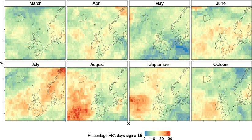
We detected 141 PPA events occurring over the UK landmass between March–October 2001–2021, averaging 6.7 events per year (Fig. 1). The average duration of a PPA event was 13.9 days (Supplementary Table S1). PPA grid cells are predominantly centred over (e.g. June), to the west (e.g. August) or the northeast (e.g. July) of the UK. PPAs are least frequent in May.
Surface fire weather is more extreme during PPA events
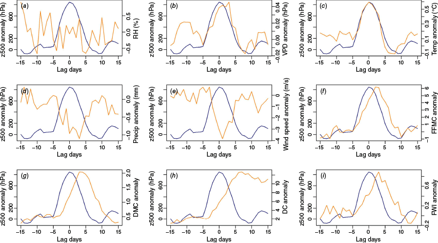
Daily noon temperatures increase with increasing PPA strength and decline following peak PPA strength (Fig. 2). Wind speed anomalies are lowest coincident with peak PPA strength, and precipitation anomalies are lowest in the 4 days following peak PPA strength. However, relative humidity anomalies do not follow this pattern, and VPD is driven by temperature rather than changes in atmospheric moisture during the PPA. The CFWIS components increase with increasing PPA strength; however, there is a lag after maximum PPA strength before anomalies peak and then a slower decline in the days following due to the slower response times of the fuel moisture codes (equilibrium drying times of 16-h for FFMC; 15 days for DMC; and 52 days for DC).
Lead-lag relationship between persistent positive anomaly (PPA) strength and surface anomalies. Blue line = z500 geopotential height anomaly for PPA strength with maximum strength on day 0. Orange line = average surface anomaly for the maximum PPA strength area 15 days either side of maximum PPA strength for (top left to bottom right) (a) noon relative humidity, (b) maximum vapour pressure deficit, (c) noon temperature, (d) 24-h accumulated precipitation, (e) noon wind speed, (f) fine fuel moisture code (FFMC), (g) duff moisture code (DMC), (h) drought code (DC), and (i) fire weather index (FWI) anomalies.
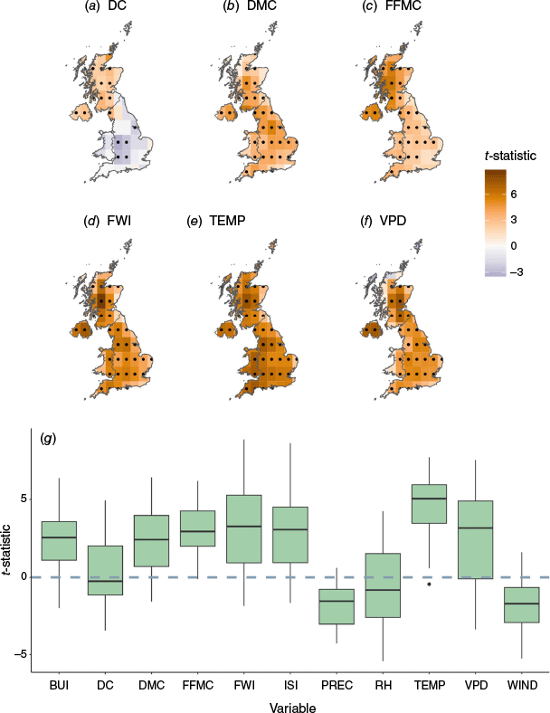
We present differences in surface weather anomalies between PPA and non-PPA days for the month of June here (Fig. 3), one of the UK’s peak summer fire months, with the results for all months presented in Supplementary Figs S2–S4 for brevity. Surface air temperature and VPD anomalies tend to be significantly higher across the UK in June when there is a PPA present, while precipitation and wind speed anomalies tend to be lower (Fig. 3). Components of the CFWIS are higher when there is a PPA present in June, except for DC anomalies, which are higher across Scotland and Northern Ireland but lower across England and Wales during PPA conditions. Differences in surface anomalies between PPA and non-PPA days are greatest in June and July, while spring surface weather is not anomalous under PPA conditions, including precipitation anomalies and the CFWIS fuel moisture codes, which are neither higher nor lower during PPAs in April (Supplementary Figs S2–S4).
(a–f) t-statistic for linear regression models comparing anomalies of the (a) drought code (DC); (b) duff moisture code (DMC); (c) fine fuel moisture code (FFMC); (d) fire weather index (FWI); (e) daily noon temperature (TEMP); and (f) daily max vapour pressure deficit (VPD) during persistent positive anomaly (PPA) days compared to non-PPA days for each 1 × 1 grid cell over the United Kingdom (UK) in June (see Supplementary Figs S2, S3 for all months and variables). t-statistics >0 (orange) show grid cells where surface anomalies are higher when there is a PPA present (larger t-statistics indicate a larger difference between PPA and non-PPA days). t-statistics <0 (purple) show grid cells where surface anomalies are lower on PPA days. Significant differences (P < 0.05) are marked by a dot in the corresponding grid cell. (g) Boxplots showing the range of t-statistics for grid cell linear regression models of surface variable anomalies between PPA and non-PPA days across the UK in June (for each boxplot, the centre line is the median, the box is the interquartile range, dots are outliers and the upper and lower whiskers are maximum and minimum values, respectively). From left to right, the variables presented are the build-up index (BUI); DC; DMC; FFMC; FWI; initial spread index (ISI); daily total precipitation (PREC), daily noon relative humidity (RH); TEMP; VPD; and daily noon wind speed (WIND). t-statistics >0 indicate larger positive anomalies when there is a PPA present (see Supplementary Fig. S4 for all months).
Vegetation fires in England
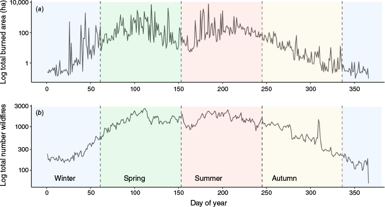
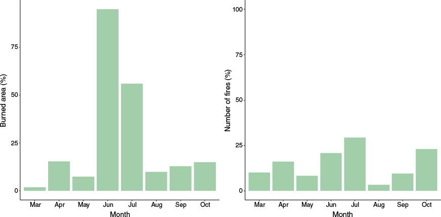
On average, over 30,000 vegetation fires are recorded in England annually, the majority of which are less than 1 ha, but episodic larger fires also occur (nearly 13,000 fires >1 ha between 2010 and 2020). The number of recorded fires is highest within built-up areas and gardens, followed by arable, grassland and woodland land covers. However, the majority of burned area in England occurs in heathland/moorlands and grasslands (Forestry Commission 2023). England experiences two main fire seasons, one in spring when shrub fuel moisture is lowest following winter dormancy and prior to green-up, and a secondary season in mid-to-late summer (Fig. 4, Supplementary Fig. S5; Belcher et al. 2021).
Total log transformed daily (a) burned area and (b) number of fire occurrences recorded in England between 2010 and 2020. Day of year on the x-axis is partitioned to show the calendar months (dashed lines) winter (December, January, February), spring (March, April, May), summer (June, July, August) and autumn (September, October, November).
Surface fire weather and vegetation fire occurrence across England
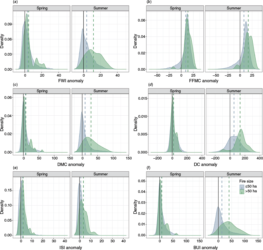
Surface fire weather, as indicated by the CFWIS indices, tends to be anomalously high when vegetation fires occur in England (Fig. 5). This is true for both spring and summer fires less than and greater than 50 ha, though fire weather anomalies are highest for larger fires in summer. In spring, the FFMC is the most elevated when vegetation fires occur, while the other indices are distributed around the average or slightly above average in the case of the FWI. In summer, the DC and BUI are anomalously high when vegetation fires occur and the FWI is positively skewed for large fires but not fires <50 ha.
Density plots showing the distribution of the Canadian Fire Weather Index System indices anomalies: (a) fire weather index (FWI), (b) fire fuel mositure code (FFMC), (c) duff moisture code (DMC), (d) drought code (DC), (e) initial speed index (ISI), and (f) build up index (BUI) for spring (left subpanel) and summer (right subpanel). Distributions are presented for fires less than or equal to 50 ha (blue fill shows the distribution, dashed blue vertical line shows the mean value) and fires greater than 50 ha (green fill shows the distribution, dashed green vertical line shows the mean value). The black vertical line at zero separates positive anomalies (indices are higher than average during fires) from negative anomalies (indices are below average during fires). Note the independent axes labels for readability.
PPAs and vegetation fire occurrences across England
Overall, 34% of England’s burned area occurs under and within 5 days of PPA conditions. There is significant monthly (Fig. 6) variability in the importance of PPAs for burned area. PPAs are most important for burned area in June (95%) followed by July (56%). The percentage of burned area associated with PPA events increases when a minimum fire size threshold is applied from 1 ha (35%), 10 ha (37%), 50 ha (39%), 100 ha (40%) to 500 ha (44%) (Table 1). The association between PPAs and the number of fires recorded is much lower overall at 16% but again increases when a minimum fire size threshold is applied up to 500 ha (48%) (Table 2). When a weaker Z500 anomaly magnitude threshold of 1× s.d. is used to define PPAs, the percentage of burned area associated with PPAs increases dramatically in April up to 79% but remains similarly high in June and July (Supplementary Table S2).
Monthly percentage of burned area (left) and number of fires (right) in England associated with PPA events between March–October 2010–2020.
| Month | All fires | >1 ha fires | >10 ha fires | >50 ha fires | >100 ha fires | >500 ha fires | |
|---|---|---|---|---|---|---|---|
| Mar | 2% (109 ha) | 1% (76 ha) | 1% (54 ha) | 0% (0 ha) | 0% (0 ha) | 0% (0 ha) | |
| Apr | 15% (3307 ha) | 15% (3198 ha) | 15% (3092 ha) | 15% (2948 ha) | 15% (2648 ha) | 15% (2118 ha) | |
| May | 7% (734 ha) | 7% (701 ha) | 7% (680 ha) | 7% (650 ha) | 8% (650 ha) | 9% (650 ha) | |
| Jun | 95% (9902 ha) | 97% (9811 ha) | 98% (9737 ha) | 99% (9630 ha) | 100% (9430 ha) | 100% (8930 ha) | |
| Jul | 56% (9947 ha) | 57% (9691 ha) | 59% (9368 ha) | 61% (8893 ha) | 63% (8840 ha) | 50% (8390 ha) | |
| Aug | 10% (509 ha) | 10% (453 ha) | 11% (372 ha) | 14% (200 ha) | 0% (0 ha) | 0% (0 ha) | |
| Sep | 13% (128 ha) | 13% (94 ha) | 24% (88 ha) | 100% (88 ha) | No fires | No fires | |
| Oct | 15% (31 ha) | 2% (3 ha) | 0% (0 ha) | 0% (0 ha) | No fires | No fires | |
| Annual | 34% (24,667 ha) | 35% (24,027 ha) | 37% (23,391 ha) | 39% (22,409 ha) | 40% (21,568 ha) | 44% (20,088 ha) |
Total area burned (ha) associated with PPA events are given in brackets.
| Month | All fires | >1 ha fires | >10 ha fires | >50 ha fires | >100 ha fires | >500 ha fires | |
|---|---|---|---|---|---|---|---|
| Mar | 10% (2896) | 5% (9) | 4% (2) | 0% (0) | 0% (0) | 0% (0) | |
| Apr | 16% (7836) | 16% (39) | 22% (14) | 23% (8) | 23% (5) | 33% (3) | |
| May | 8% (3390) | 9% (10) | 6% (2) | 8% (1) | 11% (1) | 25% (1) | |
| Jun | 21% (7185) | 39% (30) | 65% (13) | 90% (9) | 100% (7) | 100% (6) | |
| Jul | 29% (16,730) | 31% (109) | 35% (24) | 38% (6) | 63% (5) | 50% (3) | |
| Aug | 3% (1311) | 10% (37) | 10% (9) | 22% (2) | 0% (0) | 0% (0) | |
| Sep | 10% (2529) | 4% (4) | 8% (1) | 100% (1) | No fires | No fires | |
| Oct | 23% (3618) | 7% (1) | 0% (0) | 0% (0) | No fires | No fires | |
| Annual | 16% (45,495) | 16.3% (239) | 19% (65) | 25% (27) | 31% (18) | 48% (13) |
Total number of fires associated with PPA events are given in brackets.
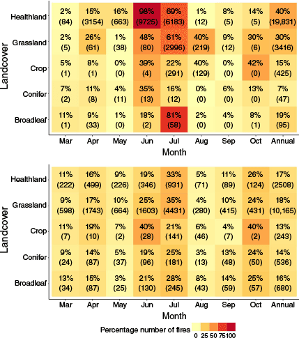
PPAs and vegetation fire burned area across key landcover types
Over 40% of all area burned from vegetation fires on heathlands/moorlands occurs during PPA events, including nearly all burned area in June (98%) (Fig. 7). The association with vegetation fire ignitions is much lower, with 17% of fires on heathland/moorlands occurring during PPAs. A total of 30% of burned area on grassland (including grassland, pasture and grazing) occurs during PPAs, while the association between burned area and PPA conditions is lowest for broadleaf forest (19%), standing crops (15%) and conifer forest (7%). While percentage burned area during PPAs shows substantial variability between landcover types and month-to-month, PPAs are associated with a similar percentage of fire ignitions across all landcovers, ranging from 13% (standing crops) to 18% (grassland).
Heat maps showing monthly percentage of burned area (top panel) and number of fires (bottom panel) associated with persistant positive anomaly (PPA) events for key United Kingdom landcover types. Tile text describes the percentage followed by the total amount of burned area associated with PPAs in hectares (top panel) and total number of fires associated with PPAs (bottom panel) in brackets.
Discussion
Large-scale drivers of fire weather in the UK and vegetation fires in England
We have demonstrated the importance of PPA events for elevated surface fire weather in the UK and as a driver of vegetation fires in England. Our results agree with other studies that have linked atmospheric blocking to heatwaves and droughts (McCarthy et al. 2019; Kay et al. 2020) and vegetation fires in the UK (Sibley 2019), as well as PPA events specifically for North America and Europe (Sharma et al. 2022; Jain et al. 2024; Little et al. 2025). But our findings provide additional insights into when different types of fuels burn during PPA events towards understanding the drivers of vegetation fire occurrence in England. Burned area and number of fire occurrences are greatest in the 0–5 days following PPA presence, which is consistent with the lag found with PPA events Europe-wide (Little et al. 2025). However, compared to other parts of Europe and North America, relative humidity anomalies are much smaller (Sharma et al. 2022; Jain et al. 2024). This is possibly due to the moderating influence of a maritime climate where high atmospheric moisture prevents the development of extremes that continental climates experience.
The relationship between PPAs and vegetation fire occurrence and burned area is strongest for large fires. It is acknowledged that there are few recorded large vegetation fires in England to date, so large burned areas >500 ha are predominantly driven by few events, notably the Saddleworth and Winter Hill fires of 2018 (Sibley 2019), and these results should be interpreted cautiously. However, the importance of PPAs for annual number of fires and burned area increases across all fire size thresholds applied (from 1 ha through to 500 ha), and as the threat from vegetation fires increases in the UK, we may see more of these large fires in the future (Arnell et al. 2021).
Seasonal role of PPAs for vegetation fire occurrence on different landcovers
England experiences two main fire seasons, one in spring and one in summer, associated with different drivers and fuels (Belcher et al. 2021; Nikonovas et al. 2024). While PPAs are important for burned area in June (95% of burned area is associated with PPAs) and July (56%), they are less important in April (15%). In April, vegetation fire occurrence is high on heathlands and moorlands. In these environments, live fuel moisture can often be very low following winter dormancy and prior to new growth during the ‘green-up’ period, and these fuels can form an important part of the fuel load for fire spread (Davies et al. 2010). Weather conditions associated with PPAs appear to be less important for heathland/moorland burned area during this spring season when phenological controls dominate (Nikonovas et al. 2024). However, when a weaker threshold of geopotential height anomaly (1× s.d.) is used to define PPAs, such as was used in Sharma et al. (2022), the importance of PPAs for burned area in April increases to 79%. This would suggest that while extreme geopotential height anomalies are less important in spring, persistent atmospheric blocking may still be an important circulation pattern for spring fires in England.
During summer, weather conditions are more conducive to fire activity in general (high temperatures and dry conditions can be experienced without requiring a PPA); however, for certain landcovers where live fuels are important for vegetation fire spread, e.g. heathlands or moorlands, live fuel moisture content is often too high for ignitions to occur (Little et al. 2024). In these situations, we hypothesise that PPA events create extended periods of elevated fire weather conditions that are needed to sufficiently dry fuels out for ignition. Furthermore, extreme drying of fuels during PPA events may increase the continuity of available fuel for fire spread and larger fires. While PPAs are important for area burned during fires, they are much less important for the frequency of ignitions. This may be due to a combination of the complexity of different human-caused ignitions, including non-climate factors such as geographic accessibility and socioeconomic factors, and the role of PPAs in increasing continuity of available dry fuels for fires to burn larger areas but not necessarily increasing the number of ignitions occurring.
The importance of PPA events for summer heathland and moorland fires in England suggests that strong wind events may be less important for large fires in these fuels compared to other countries in Europe (Ruffault et al. 2017; Carmo et al. 2022; Rodrigues et al. 2023), and it is the availability of fuel that is more of a control. This builds on the work of Little et al. (2025), which found that 95th percentile FWI anomalies were more likely to occur during PPAs for Northern Europe compared to Southern Europe, as extreme FWI values are often driven by wind speed (Dowdy et al. 2010).
To date, the dual spring and summer fire seasons have been a major challenge for predicting fire weather in the UK as the fuels burning and their drivers differ seasonally (Belcher et al. 2021). Surface fire weather indices like the FWI subcomponent of the CFWIS perform reasonably well in summer but fail to capture the spring fire season (Davies and Legg 2016; de Jong et al. 2016; Nikonovas et al. 2024), while phenological indicators (for example, vegetation greenness indices like the Enhanced Vegetation Index 2 (EVI2) (Nikonovas et al. 2024)) improve spring fire season predictions but do not capture the heatwave events during summer that can lead to extreme drying of live fuels (Ivison et al. 2024; Nikonovas et al. 2024). It is important to consider all available tools to accurately predict different periods of fire danger, including surface variables like weather, landcover and phenology, but also synoptic indicators.
Forecasting and management implications
Inclusion of synoptic indicators of fire activity like PPAs in fire occurrence prediction models provides opportunities to extend forecasting capabilities, and previous studies have demonstrated skill in forecasting geopotential heights (He et al. 2019; Weyn et al. 2019). Increasing global temperatures will lead to more extreme geopotential height anomalies (He et al. 2024), which will increase the likelihood of large vegetation fires occurring during these persistent hot, dry weather conditions (though how dynamic patterns will change in response to this warming is still uncertain). PPAs provide an approach to detect and track these extremes in space and time in order to forecast periods of elevated fire danger in the near-to-medium range. Jain et al. (2024) recently demonstrated the role of PPAs during the 2021 heat dome event in western North America, finding this event accounted for 21–34% of total burned area in 2021 and was partially attributed to climate change. A number of studies have also demonstrated the ability of synoptic fire weather patterns to predict fire weather (e.g. Lagerquist et al. 2017; Papavasileiou and Giannaros 2023; Humphrey et al. 2024). Synoptic fire weather forecasting may provide insights for fire management decision-making, including resource allocation, to prevent suppression resources from becoming overwhelmed, such as happened in the 2022 July vegetation fires in London when the UK’s first large-scale destruction of properties due to vegetation fires was experienced (London Fire Brigade 2023; John and Rein 2025).
The times of year and land covers where PPAs are not important for fires are also insightful. PPAs detect only the most extreme instances of atmospheric blocking (depending on the threshold anomaly used in the detection algorithm), and other atmospheric circulation patterns may also be important. Furthermore, understanding the drivers of days where a high number of ignitions but overall small burned area can overwhelm response resources is also important. Future work will thoroughly examine the synoptic climatology of vegetation fires in England to understand the synoptic indicators of fire beyond the hot, dry extremes of PPA events. This will allow for the development of fire weather classes for medium-range forecasting applications, as has been conducted for other countries (e.g. Skinner et al. 2002; Lagerquist et al. 2017; Rodrigues et al. 2019; Zhong et al. 2020).
The UK does not have a fire danger rating system although the Met Office Fire Severity Index (MOFSI), an adaptation of the Canadian FWI, is used to trigger land closures in England and Wales during the most extreme conditions (Met Office 2023). The evolution of PPA events through 500 hPa geopotential height forecasts could be tracked to identify periods of sustained elevated fire weather that may challenge or overwhelm available resources for fire management (Jain et al. 2024). Synoptic indicators of elevated fire danger periods would therefore provide significant benefits for near-to-medium range fire preparedness and awareness in emerging fire-prone regions like the UK where tailored assessments of fire danger do not yet exist.
Data availability
We used the R algorithm of Sharma et al. (2022) to identify PPAs over the UK landmass, and we direct the reader to this reference for further information. All climate datasets used in this paper are publicly available through the references cited and can be accessed through the web portals https://cds.climate.copernicus.eu/cdsapp#!/dataset/reanalysis-era5-complete?tab=overview (ERA5 reanalysis data for surface and upper air variables, accessed January 2022) and https://zenodo.org/record/626193#.X9pTFdhKg4s (CFWIS data, accessed January 2022). Fire records from the Home Office Incident Recording System for England can be obtained by contacting the Home Office UK.
Conflicts of interest
Mike Flannigan is an Associate Editor of International Journal of Wildland Fire but was not involved in the peer review or any decision making process for this paper. All other authors declare that they have no conflicts of interest.
Declaration of funding
This project has received funding from the NERC Highlight project NE/T003553/1.
Acknowledgements
The authors would like to thank Aseem Sharma for providing the R script of the PPA algorithm used in Sharma et al. (2022) that we used to identify PPAs.
Author contributions
All authors were involved in conceptualisation and writing – review & editing. K. L., D. C. A., and P. J. designed the methodology, curated the data, and validated the analyses. K. L. conducted the formal analyses and wrote the original draft.
References
Abatzoglou JT, Juang CS, Williams AP, Kolden CA, Westerling AL (2021) Increasing Synchronous Fire Danger in Forests of the Western United States. Geophysical Research Letters 48(2), e2020GL091377.
| Crossref | Google Scholar |
Arnell NW, Freeman A, Gazzard R (2021) The effect of climate change on indicators of fire danger in the UK. Environmental Research Letters 16(4), 044027.
| Crossref | Google Scholar |
Artés T, Castellnou M, Houston Durrant T, San-Miguel J (2022) Wildfire–atmosphere interaction index for extreme-fire behaviour. Natural Hazards and Earth System Sciences 22(2), 509-522.
| Crossref | Google Scholar |
Barnes EA, Slingo J, Woollings T (2012) A methodology for the comparison of blocking climatologies across indices, models and climate scenarios. Climate Dynamics 38(11), 2467-2481.
| Crossref | Google Scholar |
Belcher CM, Brown I, Clay GD, Doerr SH, Elliott A, Gazzard R, Kettridge N, Morison J, Perry M, Smith TEL (2021) UK Wildfires and their Climate Challenges. University of Exeter: Global Systems Institute. Available at https://www.ukclimaterisk.org/wp-content/uploads/2021/06/UK-Wildfires-and-their-Climate-Challenges.pdf
Bronaugh D, Werner A (2013) ‘zyp: Zhang + Yue-Pilon Trends Package.’ 9 pp. Available at cran.r-project.org/web/packages/zyp/zyp.pdf
Carmo M, Ferreira J, Mendes M, Silva Á, Silva P, Alves D, Reis L, Novo I, Xavier Viegas D (2022) The climatology of extreme wildfires in Portugal, 1980–2018: contributions to forecasting and preparedness. International Journal of Climatology 42(5), 3123-3146.
| Crossref | Google Scholar |
Davies GM, Legg CJ (2016) Regional variation in fire weather controls the reported occurrence of Scottish wildfires. PeerJ 4, e2649.
| Crossref | Google Scholar | PubMed |
Davies GM, Legg CJ, O’Hara R, MacDonald AJ, Smith AA (2010) Winter desiccation and rapid changes in the live fuel moisture content of Calluna vulgaris. Plant Ecology and Diversity 3(3), 289-299.
| Crossref | Google Scholar |
de Jong MC, Wooster MJ, Kitchen K, Manley C, Gazzard R, McCall FF (2016) Calibration and evaluation of the Canadian Forest Fire Weather Index (FWI) System for improved wildland fire danger rating in the United Kingdom. Natural Hazards and Earth System Sciences 16(5), 1217-1237.
| Crossref | Google Scholar |
Dole RM, Gordon ND (1983) Persistent Anomalies of the Extratropical Northern Hemisphere Wintertime Circulation: Geographical Distribution and Regional Persistence Characteristics. Monthly Weather Review 111(8), 1567-1586.
| Crossref | Google Scholar |
Dowdy AJ, Mills GA, Finkele K, de Groot W (2010) Index sensitivity analysis applied to the Canadian Forest Fire Weather Index and the McArthur Forest Fire Danger Index. Meteorological Applications 17(3), 298-312.
| Crossref | Google Scholar |
Drobyshev I, Ryzhkova N, Eden J, Kitenberga M, Pinto G, Lindberg H, Krikken F, Yermokhin M, Bergeron Y, Kryshen A (2021) Trends and patterns in annually burned forest areas and fire weather across the European boreal zone in the 20th and early 21st centuries. Agricultural and Forest Meteorology 306, 108467.
| Crossref | Google Scholar |
Duane A, Brotons L (2018) Synoptic weather conditions and changing fire regimes in a Mediterranean environment. Agricultural and Forest Meteorology 253–254, 190-202.
| Crossref | Google Scholar |
Fernandez-Anez N, Krasovskiy A, Müller M, Vacik H, Baetens J, Hukić E, Kapovic Solomun M, Atanassova I, Glushkova M, Bogunović I, Fajković H, Djuma H, Boustras G, Adámek M, Devetter M, Hrabalikova M, Huska D, Martínez Barroso P, Vaverková MD, Zumr D, Jõgiste K, Metslaid M, Koster K, Köster E, Pumpanen J, Ribeiro-Kumara C, Di Prima S, Pastor A, Rumpel C, Seeger M, Daliakopoulos I, Daskalakou E, Koutroulis A, Papadopoulou MP, Stampoulidis K, Xanthopoulos G, Aszalós R, Balázs D, Kertész M, Valkó O, Finger DC, Thorsteinsson T, Till J, Bajocco S, Gelsomino A, Amodio AM, Novara A, Salvati L, Telesca L, Ursino N, Jansons A, Kitenberga M, Stivrins N, Brazaitis G, Marozas V, Cojocaru O, Gumeniuc I, Sfecla V, Imeson A, Veraverbeke S, Mikalsen RF, Koda E, Osinski P, Castro ACM, Nunes JP, Oom D, Vieira D, Rusu T, Bojović S, Djordjevic D, Popovic Z, Protic M, Sakan S, Glasa J, Kacikova D, Lichner L, Majlingova A, Vido J, Ferk M, Tičar J, Zorn M, Zupanc V, Hinojosa MB, Knicker H, Lucas-Borja ME, Pausas J, Prat-Guitart N, Ubeda X, Vilar L, Destouni G, Ghajarnia N, Kalantari Z, Seifollahi-Aghmiuni S, Dindaroglu T, Yakupoglu T, Smith T, Doerr S, Cerda A (2021) Current wildland fire patterns and challenges in Europe: a synthesis of national perspectives. Air, Soil and Water Research 14, 11786221211028185.
| Crossref | Google Scholar |
Flannigan MD, Wotton BM, Marshall GA, de Groot WJ, Johnston J, Jurko N, Cantin AS (2016) Fuel moisture sensitivity to temperature and precipitation: climate change implications. Climatic Change 134(1–2), 59-71.
| Crossref | Google Scholar |
Franzke CLE, Barbosa S, Blender R, Fredriksen H-B, Laepple T, Lambert F, Nilsen T, Rypdal K, Rypdal M, Scotto Manuel G, Vannitsem S, Watkins NW, Yang L, Yuan N (2020) The Structure of Climate Variability Across Scales. Reviews of Geophysics 58(2), e2019RG000657.
| Crossref | Google Scholar |
Gazzard R, McMorrow J, Aylen J (2016) Wildfire policy and management in England: an evolving response from Fire and Rescue Services, forestry and cross-sector groups. Philosophical Transactions of the Royal Society of London. Series B, Biological Sciences 371(1696), 20150341.
| Crossref | Google Scholar | PubMed |
Giannaros TM, Papavasileiou G (2023) Changes in European fire weather extremes and related atmospheric drivers. Agricultural and Forest Meteorology 342, 109749.
| Crossref | Google Scholar |
Graham AM, Pope RJ, Pringle KP, Arnold S, Chipperfield MP, Conibear LA, Butt EW, Kiely L, Knote C, McQuaid JB (2020) Impact on air quality and health due to the Saddleworth Moor fire in northern England. Environmental Research Letters 15(7), 074018.
| Crossref | Google Scholar |
He B, Liu P, Zhu Y, Hu W (2019) Prediction and predictability of Northern Hemisphere persistent maxima of 500-hPa geopotential height eddies in the GEFS. Climate Dynamics 52(7), 3773-3789.
| Crossref | Google Scholar |
He C, Chen X, Collins M, Song F, Hu Y, Jiang X, Liu Y, Ding Y, Zhou W (2024) Rising geopotential height under global warming. Climate Dynamics 62, 5769-5786.
| Crossref | Google Scholar |
Hersbach H, Bell B, Berrisford P, Hirahara S, Horányi A, Muñoz-Sabater J, Nicolas J, Peubey C, Radu R, Schepers D, Simmons A, Soci C, Abdalla S, Abellan X, Balsamo G, Bechtold P, Biavati G, Bidlot J, Bonavita M, De Chiara G, Dahlgren P, Dee D, Diamantakis M, Dragani R, Flemming J, Forbes R, Fuentes M, Geer A, Haimberger L, Healy S, Hogan RJ, Hólm E, Janisková M, Keeley S, Laloyaux P, Lopez P, Lupu C, Radnoti G, de Rosnay P, Rozum I, Vamborg F, Villaume S, Thépaut J-N (2020) The ERA5 global reanalysis. Quarterly Journal of the Royal Meteorological Society 146(730), 1999-2049.
| Crossref | Google Scholar |
Hijmans RJ (2022a) ‘raster: Geographic Data Analysis and Modeling.’ R package version 3.6-32. https://github.com/rspatial/raster
Hijmans RJ (2022b) ‘terra: Spatial Data Analysis.’ R package version 1.8-58. https://github.com/rspatial/terra
Hohenegger C, Schär C (2007) Atmospheric Predictability at Synoptic Versus Cloud-Resolving Scales. Bulletin of the American Meteorological Society 88(11), 1783-1793.
| Crossref | Google Scholar |
Humphrey R, Saltenberger J, Abatzoglou JT, Cullen A (2024) Near-term fire weather forecasting in the Pacific Northwest using 500-hPa map types. International Journal of Wildland Fire 33(5), WF23117.
| Crossref | Google Scholar |
Ivison K, Little K, Orpin A, Lewis CHM, Dyer N, Keyzor L, Everett L, Stoll E, Andersen R, Graham LJ, Kettridge N (2024) A national-scale sampled temperate fuel moisture database. Scientific Data 11(1), 973.
| Crossref | Google Scholar | PubMed |
Jain P, Sharma AR, Acuna DC, Abatzoglou JT, Flannigan M (2024) Record-breaking fire weather in North America in 2021 was initiated by the Pacific northwest heat dome. Communications Earth & Environment 5(1), 202.
| Crossref | Google Scholar |
John J, Rein G (2025) Heatwaves and firewaves: the drivers of urban wildfires in London in the summer of 2022. Fire Technology.
| Crossref | Google Scholar |
Kay G, Dunstone N, Smith D, Dunbar T, Eade R, Scaife A (2020) Current likelihood and dynamics of hot summers in the UK. Environmental Research Letters 15(9), 094099.
| Crossref | Google Scholar |
Kirkland M, Atkinson PW, Pearce-Higgins JW, de Jong MC, Dowling TPF, Grummo D, Critchley M, Ashton-Butt A (2023) Landscape fires disproportionally affect high conservation value temperate peatlands, meadows, and deciduous forests, but only under low moisture conditions. Science of The Total Environment 884, 163849.
| Crossref | Google Scholar | PubMed |
Lagerquist R, Flannigan MD, Wang X, Marshall GA (2017) Automated prediction of extreme fire weather from synoptic patterns in northern Alberta, Canada. Canadian Journal of Forest Research 47(9), 1175-1183.
| Crossref | Google Scholar |
Little K, Graham LJ, Flannigan M, Belcher CM, Kettridge N (2024) Landscape controls on fuel moisture variability in fire-prone heathland and peatland landscapes. Fire Ecology 20(1), 14.
| Crossref | Google Scholar |
Little K, Castellanos-Acuna D, Jain P, Graham L, Kettridge N, Flannigan M (2025) Persistent positive anomalies in geopotential heights drive enhanced wildfire activity across Europe. Philosophical Transactions of the Royal Society of London. Series B, Biological Sciences 380(1924), 20230455.
| Crossref | Google Scholar | PubMed |
Liu P, Zhu Y, Zhang Q, Gottschalck J, Zhang M, Melhauser C, Li W, Guan H, Zhou X, Hou D, Peña M, Wu G, Liu Y, Zhou L, He B, Hu W, Sukhdeo R (2018) Climatology of tracked persistent maxima of 500-hPa geopotential height. Climate Dynamics 51(1), 701-717.
| Crossref | Google Scholar |
London Fire Brigade (2023) Major Incident Review Extreme Weather Period 2022. Available at https://www.london-fire.gov.uk/media/7881/lfc-23-014-major-incident-review-extreme-weather-period-2022.pdf
Masinda MM, Li F, Qi L, Sun L, Hu T (2022) Forest fire risk estimation in a typical temperate forest in Northeastern China using the Canadian forest fire weather index: case study in autumn 2019 and 2020. Natural Hazards 111(1), 1085-1101.
| Crossref | Google Scholar | PubMed |
McCarthy M, Christidis N, Dunstone N, Fereday D, Kay G, Klein-Tank A, Lowe J, Petch J, Scaife A, Stott P (2019) Drivers of the UK summer heatwave of 2018. Weather 74(11), 390-396.
| Crossref | Google Scholar |
Met Office (2023) England and Wales Fire Severity Index. Available at https://www.metoffice.gov.uk/public/weather/fire-severity-index [accessed 25 April 2023]
Miller RL, Lackmann GM, Robinson WA (2020) A New Variable-Threshold Persistent Anomaly Index: Northern Hemisphere Anomalies in the ERA-Interim Reanalysis. Monthly Weather Review 148(1), 43-62.
| Crossref | Google Scholar |
NFCC (2025) ‘Climate Change Position Statement.’ (NFCC) Available at https://nfcc.org.uk/our-services/position-statements/climate-change-position-statement/ [accessed 10 February 2025]
Nikonovas T, Santín C, Belcher CM, Clay GD, Kettridge N, Smith TEL, Doerr SH (2024) Vegetation phenology as a key driver for fire occurrence in the UK and comparable humid temperate regions. International Journal of Wildland Fire 33(10), WF23205.
| Crossref | Google Scholar |
Pandey P, Huidobro G, Lopes LF, Ganteaume A, Ascoli D, Colaco C, Xanthopoulos G, Giannaropoulos T, Gazzard R, Boustras G, Steelman T, Charlton V, Ferguson E, Kirschner J, Little K, Stoof C, Nikolakis W, Fernández-Blanco CR, Ribotta C, Lambrechts H, Fernandez M, Dossi S (2023) A global outlook on increasing wildfire risk: current policy situation and future pathways. Trees, Forests and People 100431.
| Crossref | Google Scholar |
Papavasileiou G, Giannaros TM (2023) The Predictability of the Synoptic-Scale Fire Weather Conditions during the 2018 Mati Wildfire. Environmental Sciences Proceedings 26(1), 164.
| Crossref | Google Scholar |
Pelly JL, Hoskins BJ (2003) A New Perspective on Blocking. Journal of the Atmospheric Sciences 60, 743-755.
| Crossref | Google Scholar |
Perry MC, Vanvyve E, Betts RA, Palin EJ (2022) Past and future trends in fire weather for the UK. Natural Hazards and Earth System Sciences 22(2), 559-575.
| Crossref | Google Scholar |
Pineda N, Peña JC, Soler X, Aran M, Pérez-Zanón N (2022) Synoptic weather patterns conducive to lightning-ignited wildfires in Catalonia. Advances in Science and Research 19, 39-49.
| Crossref | Google Scholar |
Pinheiro MC, Ullrich PA, Grotjahn R (2019) Atmospheric blocking and intercomparison of objective detection methods: flow field characteristics. Climate Dynamics 53(7–8), 4189-4216.
| Crossref | Google Scholar | PubMed |
Resco de Dios V, Cunill Camprubí À, Pérez-Zanón N, Peña JC, Martínez del Castillo E, Rodrigues M, Yao Y, Yebra M, Vega-García C, Boer MM (2022) Convergence in critical fuel moisture and fire weather thresholds associated with fire activity in the pyroregions of Mediterranean Europe. Science of The Total Environment 806, 151462.
| Crossref | Google Scholar | PubMed |
Rex DF (1950) Blocking action in the middle troposphere and its effect upon regional climate. Tellus 2(3), 196-211.
| Crossref | Google Scholar |
Rodrigues M, González-Hidalgo JC, Peña-Angulo D, Jiménez-Ruano A (2019) Identifying wildfire-prone atmospheric circulation weather types on mainland Spain. Agricultural and Forest Meteorology 264, 92-103.
| Crossref | Google Scholar |
Rodrigues M, Camprubí ÀC, Balaguer-Romano R, Ruffault J, Fernandes PM, de Dios VR (2023) Drivers and implications of the extreme 2022 wildfire season in Southwest Europe. Science of The Total Environment 859, 160320.
| Crossref | Google Scholar |
Ruffault J, Moron V, Trigo RM, Curt T (2017) Daily synoptic conditions associated with large fire occurrence in Mediterranean France: evidence for a wind-driven fire regime. International Journal of Climatology 37(1), 524-533.
| Crossref | Google Scholar |
San-Miguel-Ayanz J, Schulte E, Schmuck G, Camia A, Strobl P, Liberta G, Giovando C, Boca R, Sedano F, Kempeneers P, McInerney D, Withmore C, de Oliveira SS, Rodrigues M, Durrant T, Corti P, Oehler F, Vilar L, Amatulli G (2012) Comprehensive Monitoring of Wildfires in Europe: The European Forest Fire Information System (EFFIS). In ‘Approaches to Managing Disaster - Assessing Hazards, Emergencies and Disaster Impacts’. (Ed. J Tiefenbacher) pp. 87–108. (InTech)
Sharma AR, Jain P, Abatzoglou JT, Flannigan M (2022) Persistent Positive Anomalies in Geopotential Heights Promote Wildfires in Western North America. Journal of Climate 35(19), 2867-2884.
| Crossref | Google Scholar |
Sibley AM (2019) Wildfire outbreaks across the United Kingdom during summer 2018. Weather 74(11), 397-402.
| Crossref | Google Scholar |
Skinner WR, Flannigan MD, Stocks BJ, Martell DL, Wotton BM, Todd JB, Mason JA, Logan KA, Bosch EM (2002) A 500 hPa synoptic wildland fire climatology for large Canadian forest fires, 1959–1996. Theoretical and Applied Climatology 71(3), 157-169.
| Crossref | Google Scholar |
Small D, Atallah E, Gyakum JR (2014) An Objectively Determined Blocking Index and its Northern Hemisphere Climatology. Journal of Climate 27(8), 2948-2970.
| Crossref | Google Scholar |
Sousa PM, Trigo RM, Barriopedro D, Soares PMM, Santos JA (2018) European temperature responses to blocking and ridge regional patterns. Climate Dynamics 50(1), 457-477.
| Crossref | Google Scholar |
Steinfeld D, Peter A, Martius O, Brönnimann S (2022) Assessing the performance of various fire weather indices for wildfire occurrence in Northern Switzerland. EGUsphere 2022, 1-23.
| Crossref | Google Scholar |
Stoof CR, Kok E, Cardil Forradellas A, van Marle MJE (2024) In temperate Europe, fire is already here: the case of The Netherlands. Ambio 53, 604-623.
| Crossref | Google Scholar |
Tibaldi S, Molteni F (1990) On the operational predictability of blocking. Tellus A: Dynamic Meteorology and Oceanography 42(3), 343-365.
| Crossref | Google Scholar |
Wastl C, Schunk C, Lüpke M, Cocca G, Conedera M, Valese E, Menzel A (2013) Large-scale weather types, forest fire danger, and wildfire occurrence in the Alps. Agricultural and Forest Meteorology 168, 15-25.
| Crossref | Google Scholar |
Weyn JA, Durran DR, Caruana R (2019) Can machines learn to predict weather? Using deep learning to predict Gridded 500-hPa geopotential height from historical weather data. Journal of Advances in Modeling Earth Systems 11(8), 2680-2693.
| Crossref | Google Scholar |
Woollings T, Barriopedro D, Methven J, Son S-W, Martius O, Harvey B, Sillmann J, Lupo AR, Seneviratne S (2018) Blocking and its response to climate change. Current Climate Change Reports 4(3), 287-300.
| Crossref | Google Scholar | PubMed |
World Bank (2022) World Bank Open Data. Available at https://data.worldbank.org
Zhong S, Yu L, Heilman WE, Bian X, Fromm H (2020) Synoptic weather patterns for large wildfires in the northwestern United States—a climatological analysis using three classification methods. Theoretical and Applied Climatology 141(3–4), 1057-1073.
| Crossref | Google Scholar |