A comparison of weather systems in 1870 and 1956 leading to extreme floods in the Murray–Darling Basin
Jeff CallaghanA Retired. Bureau of Meteorology, Brisbane, Qld., Australia. Postal address: 3/34 Macalister Road, Tweed Heads, NSW 2486, Australia. Email: jeffjcallaghan@gmail.com
Journal of Southern Hemisphere Earth Systems Science 69(1) 84-115 https://doi.org/10.1071/ES19003
Submitted: 6 December 2018 Accepted: 29 January 2019 Published: 11 June 2020
Journal Compilation © BoM 2019 Open Access CC BY-NC-ND
Abstract
This research is the extension of a project studying the impact of 19th century severe weather events in Australia and their relation to similar events during the 20th and 21st century. Two floods with the worst known impacts in the Murray–Darling Basin (MDB) are studied. One of these events which occurred during 1956 is relatively well known and the Bureau of Meteorology archives contain good rainfall data covering the period. Additionally, information on the weather systems causing this rainfall can be obtained. Rainfall, flood and weather system data for this event are presented here and compared with a devastating event during 1870. Although archived Australian rainfall data is negligible during 1870 and there is no record of weather systems affecting Australia during that year, a realistic history of the floods and weather systems in the MDB during 1870 is created. This follows an extensive search through newspaper archives contained in the National Library of Australia’s web site. Examples are presented showing how the meteorological data in 19th century newspapers can be used to create weather charts. Six such events in 1870 are demonstrated and three of these had a phenomenal effect on the Murray–Darling system. The 1870 floods followed drought type conditions and it is remarkable that it was worse in many ways than the 1956 event which followed flood conditions in the MDB during the previous year. The events in 1870 caused much loss of life from drowning in the MDB in particular from an east coast low (ECL) in April 1870 and two Victorian weather systems in September and October 1870. In 1956, there were also record-breaking events especially during March when all-time record monthly rainfall were reported in New South Wales. Overall the greatest impact from flooding across the whole MDB was associated with the 1870 flooding. Analyses of heavy rainfall areas in the MDB showed a linear trend increase from 1900 to 2018. Analysing the same data using an 8-year moving average highlighted three peaks around the five highest annual rainfall years. The largest peak occurred around 1950 and 1956, the second largest around 1973 and 1974 and the third around 2010. Each of these 5 years occurred during negative phases of the Interdecadal Pacific Oscillation (IPO) and positive phases of the Southern Oscillation Index (SOI). Studies have shown that the SOI is a climate driver in the MDB along with a persistent blocking high-pressure systems south of Australia along longitude 140°E with a low to its north. Three major blocking events with record rainfall and flooding in the MDB occurred in 1983, 1984 and 1990. This was during the period 1977–1990 when blocking was conducive to heavy rain in the MDB and was coincident with a positive phase of the IPO, thus helping conflict with the IPO–MDB heavy rainfall relationship. Persistent and unexplained middle level westerly winds kept subtropical Queensland clear of tropical cyclones during the negative phases of the IPO from 1999 to 2009 and during the 1960s, influencing low rainfall in the MDB during those periods.
1 Introduction
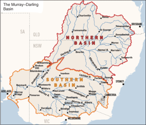
The topic which concerns many people around the globe today is whether climate change is producing more extreme weather events, and to this end we have previously studied the impacts of east coast lows (ECLs), tropical cyclones (TCs) and related weather systems in Australia (Power and Callaghan 2015, 2016; Callaghan and Power 2014a, 2014b; Callaghan and Power 2011; Callaghan and Helman 2008). This work is now extended to study extreme flooding in the Murray–Darling basin (MDB). The MDB is a large geographical area in the interior of south-eastern Australia and contains two major rivers, the Murray and the Darling (see Fig. 1) and drains about one-seventh of the Australian land mass. Most of its area (1 061 469 km2) is flat. The basin, which is one of the most significant agricultural areas in Australia, generally receives little direct rainfall, and the rivers it contains tend to be long and slow-flowing and most of the time carry a relatively low volume of water. For example, in relation to the slow-flowing rivers, the peak flow travel time along the Darling River from Bourke to Wilcannia is about 20 days and along the Murray River from Hume Weir (near Albury) to Wentworth is around 27 days and a further 2 weeks to reach Renmark.
|
The two largest floods in the MDB since European Settlement appear to be the 1870 and 1956 floods. The 1870 flood was the first officially recorded flood. It then was reported (see http://www.samemory.sa.gov.au/site/page.cfm?u=1378, accessed 27 April 2020) as peaking at 11 m (no decimals given) at Morgan in South Australia (SA), where the Murray River turns 90° southward. Morgan is 38 km north-northeast of Blanchetown which is 90 km north-northeast of Murray Bridge. The Sergeant of Police at Blanchetown gave the highest water level occurring on 13 December 1870. It washed away homesteads in the region. From Harrison (1957), except in the SA section of the Murray River where the 1956 flood was higher than previously recorded, the 1870 flood was the highest at most places in the Murray River itself.
Prior to the 1956 flood, an earlier flood during late October 1955 peaked at 8.3 m at Morgan and pre-empted the 1956 flood. From the above SA Government site, the 1956 flood peaked at 12.3 m at Morgan, breached all levees and was the highest flood recorded there since white settlement. Traditionalists argue that it was only the locks in the Murray River that made it higher than the 1870 flood. Additionally, the 1955 floods ensured a moist catchment in 1956 so that less potent rain-bearing systems could produce severe flooding than that would occur on a dry catchment.
Trevor Jacobs, Manager of Production, River Murray Water, presented the following facts about the 1870 and 1956 floods:
The peak flood height at Lock 11 at Mildura in Victoria (Vic.) during 1956 was 11.43 metres but it was exceeded previously in 1870 by about 0.2 of a metre – it was 11.65 metres in 1870. But 1956 further downstream where the Darling joins in, it was the highest ever recorded. At Wentworth New South Wales (NSW) during 1956, the Murray was measured 9.75 metres and in 1870 it was 10.05 metres. The 1870 readings are thought to be accurate. In 1956 the Darling River flood came down the anabranch downstream of Wentworth and became the largest flood downstream of Wentworth about 30cm higher than in 1870. These floods move slowly along the river, taking three days for the peak to make its way from Mildura to Wentworth, and then nearly two weeks to reach Renmark in SA. The water went down just as slowly, exposing the muddy flood plain left behind in the waters’ wake.
The aim of this study is to help identify and document the weather systems causing the 1870 floods and to compare them with the systems causing the 1956 floods. Below in Section 2, the data used in this study is examined. Section 3 describes the rating of floods and Section 4 refers to some MDB climate studies. Section 5 describes the six major weather systems in 1870. Precursor conditions to the 1870 floods are analysed in Section 6 along with a description of the 1870 weather systems and resultant floods in Section 7. Sections 8 and 9 similarly explain the 1956 conditions. The conclusions are presented in Section 10.
Appendices are added with Appendix 1 showing greater detail of the 1870 and 1956 weather systems and impacts, whereas Appendix 2 presents the occurrences of rainfall reported during other 1870 weather systems. Appendix 3 details the ECLs affecting Eastern Victoria since the 19th century.
2 Data
As stated above, the main aim of this study is to compare the weather systems causing the 1870 floods with the 1956 events. There is little rainfall data available for 1869 and 1870 and little knowledge of the weather systems involved, so it becomes essential to use newspaper archived data from the National Library of Australia. Following Callaghan and Power (2014a), the newspaper archives of the National Library of Australia (https://trove.nla.gov.au/newspaper/, accessed 27 April 2020) were searched to build a picture of the activity of rainfall, flooding and weather systems affecting the MDB during 1870. Daily newspapers contained weather observations and flooding information in the northern, eastern and southern areas of the MDB during 1870, and from April onwards when the Darling River began flowing properly after early rainfall, there were reports from steamers moving up and down the Darling River.
Newspapers carried many accounts of flooding around this period probably due to the huge loss of life in NSW from ECLs producing the May 1851 Bega floods, the June 1852 Gundagai floods, the August 1857 Dunbah Storm, the 1963, 1864 and 1867 tropical cyclones (TCs) in Queensland (Qld) and the June 1867 ECL Hawkesbury River floods (see Callaghan and Power 2014a, 2014b; Callaghan and Helman 2008). Over this period as a result of these storms there was an even greater loss of life from coastal shipping disasters, so newspapers during 1870 contained daily coastal weather and sea observations which enabled weather systems such as ECLs and TCs to be identified.
In contrast there are widespread available rainfall data and weather charts available for the 1956 events.
3 Rating of floods events
The probability of a particular flood level being equalled or exceeded in any 1-year period can be expressed as a percentage, the annual exceedance probability or AEP, or as an average recurrence interval, or ARI. As an example take a flood level which can be expected to be equalled or exceeded on average once every 100 years. In this case, the ARI is 100 years and the AEP is 1%. It is important to note that an ARI of, say, 100 years does not mean that the event will only occur once every 100 years. In fact, for each and every year, there is a 1% chance (a 1 in 100 chance) that the event will occur. The use of AEP to describe the chance of a particular rainfall is generally preferred as it conveys the probability or chance that exists for each year. The alternative, ARI, is a term which is easily misunderstood; however, it is more widely used and appears to be favoured by the public, so we use it here.
4 Climate studies affecting the Murray–Darling basin
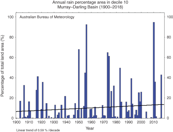
From a network of reliable long-term rainfall stations, the area of rainfall very much above average (decile 10) in the MDB has been increasing over the period 1900–2018 with Fig. 2 showing the decile 10 linear trend. Note 2010 was also the wettest year on record for the MDB; however, it relieved one of the longest and most severe droughts across the MDB in recorded history. There is a clustering of events in the period 1950–1980 in Fig. 2, so Fig. 3 displays the 8-year moving average, and this shows clearly that the two largest peaks in rainfall occurred in the 1945–1976 period and a third peak near the 2010 extreme rainfall event.
|

|
The 8-year moving average was chosen as the heaviest rainfall areas appeared to be associated with the negative phases of the Interdecadal Pacific Oscillation (IPO) (Power et al. 1999; Henley et al. 2017), and longer periods smoothed out the rainfall between the two phases of the IPO. The 1945–76 period was the most extensive negative period in all the IPO data. IPO negative values (from UK Met Office data) and Southern Oscillation positive values (monthly average for each year) for the five largest annual rainfall totals in the time series which are also the years with the largest areas of decile 10 rainfall were
1950 − 1.838 + 15.3
1956 − 1.475 + 10.7
1973 − 1.450 + 10.6
1974 − 1.305 + 9.6
2010 − 1.238 + 9.8
The IPO is a long-term oscillation of sea-surface temperatures in the Pacific Ocean that can last from 20 to 30 years. Its positive and negative phases affect the strength and frequency of El Niño and La Niña. The IPO was mainly positive from 1900 to 1944, then positive from 1977 to 1998 and again from 2014 onwards. It was negative from 1945 to 1976 and 1999 to 2014. The positive phases are dominated by El Niño events, whereas the negative phases are dominated by La Niña events. Therefore, the positive phases of the IPO before 1945, from 1977 to 1998 and after 2014 are associated with fewer periods of heavy rain in the MDB, and the two negative phases from 1945 to 1976 and 2000 to 2014 are associated with heavier rainfall.
Negative periods of the IPO have been found to be associated with enhanced severe TC landfalls along the east coast of Australia (Callaghan and Power 2011) and more frequent major flooding along the subtropical east coast of Australia (Power and Callaghan 2015). We show below that land-falling TCs and subtropical east coast flooding led to increased rainfall in the MDB in 1870 and 1956. Risbey et al. 2009 showed that the Southern Oscillation Index was a strong climate driver in the MJB along with situations where a blocking high forms around longitude 140°E and a cut off low forms equator ward of the high. An example of this occurred from 19 to 20 April 1990 when a high near 140°E had a low form to its north near Charleville and move down towards Nyngan and then on 21 April 1990 moved through Central NSW to Gippsland causing unprecedented major flooding at Charleville, Nyngan and Gippsland and caused seven deaths. A monsoon low near Broome on 9 January 1984 moved SE through the desert to be near Alice Springs on 12 January 1984 then near Moomba SA on 14 January and near Broken Hill on 15 January 1984 producing widespread floods in the Northern Territory, Western Qld and large areas of NSW. There was a similar event in March 1983 where a low tracked from the Kimberley down to Victoria breaking the 1982–83 drought. These blocking events were aligned with the positive IPO period and Risbey et al. (2009) showed blocking at 140°E to be more conducive to rainfall across the MDB from 1997 to 2005 than for the earlier period 1948–76. This is opposite to the rainfall which would be expected from the IPO. This kept the MDB rainfall higher than expected during the 1977–98 positive IPO period. The drought from the start of the next negative period in 1999–2009 was coincident with no TCs making land fall along the east coast of Australia south of Mackay between 1999 and 2009. During this period, persistent and unexplained middle level westerly winds extended northwards into the Coral Sea steering TCs away from Australia or weakening those moving towards the coast. A similar occurrence occurred during the 1960s when low rainfall also resulted in the MDB during a negative IPO period (see Fig. 3). This persistent middle level westerly flow generally extended into adjacent overland areas, and from Callaghan and Power (2016) such flow is not associated with heavy rainfall which also restricted river flow into the MDB. The Severe Weather Section of the Bureau of Meteorology in Qld researched this anomalous westerly flow following desperate enquiries form Qld Government Climate officers, Emergency Services officers and Brisbane City Council staff personnel during the millennium drought. They were desperate following the general assertion that the drought could persist indefinitely.
Alexander and Power (2009) and Alexander et al. (2011) indicated that intense weather systems extending from the Southern Ocean into the MDB have been in decline through the 20th century and thus reducing rainfall in southern Australia. The eastern most data points in their 2011 paper which describes a decline in storminess in south-east Australia are Goondiwindi, Deniliquin and Hobart. Whetton (1990) showed rainfall in eastern Victoria, which is where the heaviest rainfall occurs, to be associated with low-pressure systems east of these data points in the Tasman Sea. There is a possible increase in the occurrence of ECLs in Victoria and in related systems along the east coast of New South Wales and Southern Qld on a scale larger than the change in blocking activity described above. This warrants further investigation which is planned.
In a study we are carrying out on heavy flood rain systems occurring in Victoria, 388 systems were identified between 1849 and 2017. In this study we took advantage of a Victorian Government list of major floods from the 19th century through to 2007 available on the webhttp://www.floodvictoria.vic.gov.au/centric/learn_about_flooding/flood_history/pre_1900_floods.jsp, accessed 27 April 2020.
Major floods since then are obtained from the Bureau of Meteorology data. We added other events with significant impact from heavy rain to these in a similar fashion and using similar data to those documented in Callaghan and Power (2014a). The 388 events have been reduced to 292 high-impact events, and 121 of these were associated with ECLs (affecting mainly Eastern Victoria and south-east New South Wales). These 121 ECL events are listed in Appendix 3. The ECLs have much of their intense pressure gradient east of the eastern most data points of Goondiwindi, Deniliquin and Hobart in the triangular system employed by Alexander et al. (2011) which would affect the tendencies they documented. There has been a trend for ECLs affecting Victoria to increase during the 20th century with 36 events over the 50-year period 1900–49 (0.72 per year) and 69 events over the 68 years from period 1950 to 2016 (just over 1 per year). The Victorian 8-year moving average decile 10 rainfall (not shown) shows the three largest peaks occurred in the 1950s, 1970s and in the 2010–16 period consistent with this increase.
Therefore, the occurrence of an increased number of ECLs would be consistent with decreased storminess using their triangular system. As ECLs overall have their rainfall concentrated in Eastern Victoria and News South Wales, the contribution to decreased storminess in Western Victoria from ECLs would result in decreased rainfall in Western Victoria and western New South Wales. It is notable that in these Western regions the triangular system had a strong relationship with rainfall in Alexander et al. (2011). From Power and Callaghan (2016) there has been an increase in major flooding over a similar period in coastal areas east of the MDB, and the weather systems involved were mostly ECLs and similar tropical and subtropical lows. This differs from Speer (2008), whose study was for Coastal NSW heavy rainfall, whereas the former study was for major flooding, including south-east Qld and extending an extra 7 years to 2013, thereby including a later active negative phase of the IPO.
Many of these 388 weather rain-bearing systems described above did not have the intense pressure gradients like those described in Alexander et al. (2011), and none of those 388 were associated with the shipwrecks in Alexander and Power (2009, table 2). Reasons for this include that the intense weather systems move too quickly, and rainfall spends little time at any one location and the airstreams associated with these systems are often too dry to generate heavy precipitation. Nevertheless some of the most violent storms have produced extreme flooding, for example, event 41 in Appendix 3 on 1 December 1934 caused the worst flooding ever experienced around Melbourne and 20 people perished overland and 17 at sea. Reasons for the extreme rainfall were probably due to a tropical north to north-east airflow ahead of an intensifying low which became slow moving in eastern Bass Strait.
We frequently observe severe windstorms through southern Victoria which do not produce exceptional rainfall, and there have been 14 such events since June 2014. Two of these events are described below along with the infamous 1998 Yacht race storm:
During 26–27 December 1998 a deep low moved at 30 km/h just seawards of the Gippsland Coast while rapidly intensifying. On the 27th, gales and severe gusts occurred in Gippsland. Tree and building damage was reported in the Rosedale to Orbost area. Severe gusts were experienced at Wilsons Promontory 171 km/h, East Sale 152 km/h and Bairnsdale 107 km/h. Storm to hurricane force winds occurred in Bass Strait (Mills 2001) and six yachtsman were killed in the Sydney to Hobart Yacht Race. Unprecedented wave heights developed in eastern Bass Strait due to the rapid forward speed of the low causing fetch enhancement (Dysthe and Harbitz 1987). A world record wave height was measured from a radio altimeter during an unbelievable rescue mission by a helicopter pilot (Joubert 2005). The top Victorian 24 h rainfall to 2200 UTC 26 December 1998 was a modest 69.8 mm at Coranderrk Badger Weir (360-m elevation).
During 9–10 October 2016 a front moving at 37 km/h passed through Melbourne. The Victorian Emergency Services received more than 5220 calls for assistance. Twenty four rainfall totals in the Melbourne and Gippsland region were 5–10 mm.
A deep low, 985 hPa, on 24 June 2014 moved into waters just south of Melbourne at 47 km/h. severe wind gusts downed trees, roof damage and collapsed walls with two deaths. Flooding in beachside suburbs and the Yarra River caused significant disruption to power and transport as well as widespread coastal erosion. The flood peak in the Yarra River (1.75 m) was notable because it was not associated with heavy rain. Victorian State Emergency Service had 3500 call outs. The heaviest rainfall in the Yarra catchment in the 24 h to 2300 UTC 24 June 2014 was 32.2 mm around Melbourne and 52.4 in the hills at Warburton.
Ho et al. (2015) presented MDB rainfall reconstructions based on a novel method using paleoclimate rainfall proxies in the Australasian region spanning from 749 BCE to 1980 CE. This study shows that prior to the 20th century, both dry and wet epochs have persisted for longer periods than observed in the instrumental record – with the probability of both dry and wet periods exceeding a decade at least 10 times more likely prior to 1883 than suggested by the instrumental records. Timbal and Fawcett (2013) explored the possibility of using those 19th-century observations that do exist to construct an estimate of rainfall across the south-eastern part of Australia (SEA). This is based on 11 locations comprising either single observing sites or composites of nearby observing sites with long continuous records. This determined a high peak in rainfall during the 1870s comparable to similar wet decadal peaks in the 1950s and 1970s.
5 Schematic mean sea level analyses of the most potent rain-producing systems during 1870
These analyses are created from the observations in the various newspapers which contain pressure data not corrected to mean sea level and in most cases no indication of the elevation of the observation sites even in the major cities. The contours drawn are only indicative of the isobars. Wind speeds are inferred from the subjective descriptions of the wind observations, for example, light, moderate, fresh, strong and gale force.
As an example of the available weather observations, below is a link to some of the weather observations contained in The Sydney Morning Herald of 27 April 1870. The Melbourne Age and Argus, Brisbane Courier-Mail and Adelaide newspapers were also sourced for weather observations. https://trove.nla.gov.au/newspaper/article/28420115?browse=ndp%3Abrowse%2Ftitle%2FS%2Ftitle%2F35%2F1870%2F04%2F27%2Fpage%2F1459994%2Farticle%2F28420115, accessed 27 April 2020.
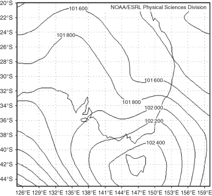
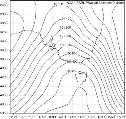
The analyses were hand drawn (using nearly 50 years of experience) with the only pressure data coming from Brisbane, Sydney, Melbourne and Adelaide, so they are necessarily schematic analyses. To a trained eye, the wind observations and rain alone reveal the location of the low-pressure systems. These analyses were compared with mean sea level pressure analyses with those from the 20th-century reanalysis (https://www.esrl.noaa.gov/psd/data/20thC_Rean/, accessed 27 April 2020). These reanalyses ensemble means assimilate only surface observations of synoptic pressure, monthly sea-surface temperature and sea-ice distribution. It was found that these analyses cannot resolve mesoscale low-pressure systems. Two analyses are shown below in Figs 4 and 5 for 0000 UTC 26 April 1870 and the second at 0000 UTC 8 September 1870.
|
|
They both provided some information regarding the synoptic environments of the two systems – in the first case, the storm was located in an easterly wind regime; however, only a broad trough in the easterlies was present compared with the ECL actually analysed in the lower left frame of Fig. 8 . Likewise 8 September 1870 was located in a westerly wind regime with only a trough system present, whereas the lower frame of Fig. 10 shows the corresponding analyses with an intense low near Melbourne. All the other cases were similar with broad trough features in the reanalyses rather than intense mesoscale lows. If there was some way to incorporate some of the wind observations available from the newspapers into the model, obviously the reanalyses will markedly improve.
5.1 4–10 March 1870
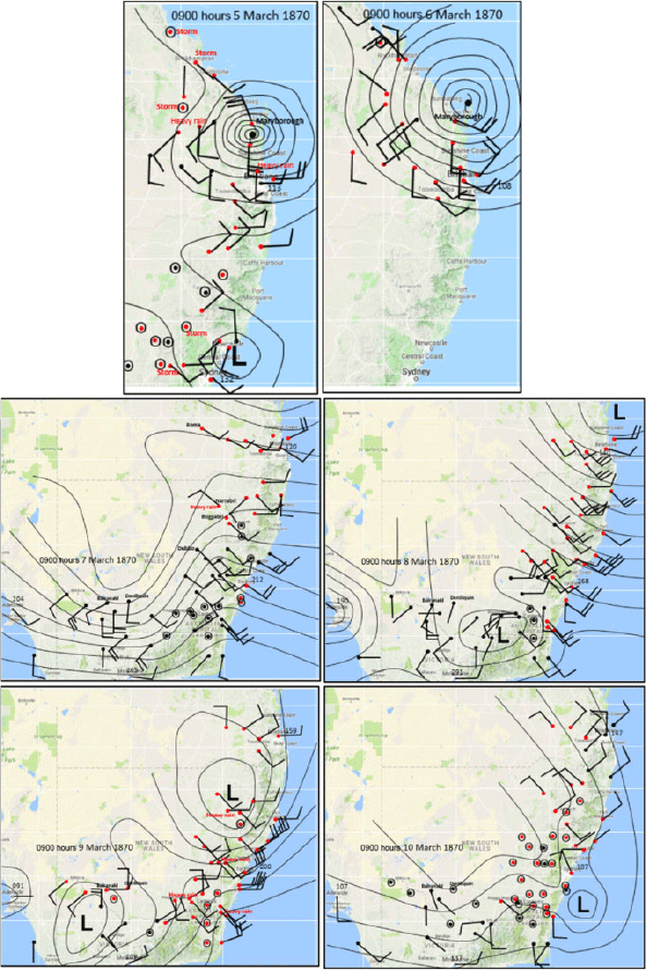
A TC crossed the coast near Maryborough in Qld and then became slow moving overland north of Brisbane. Prior to the analyses in Fig. 6, the cyclone had been hovering off the Qld Coast and with the tropical moisture it brought into New South Wales rain extended across that state. The top two frames of Fig. 6 show the cyclone just south of Maryborough (left frame of Fig. 6) on 2300 UTC 4 March 1870 (0900 hours local time 5th) with rain and thunderstorms and thunderstorms extending south to the Sydney area. In the right frame for 2300 UTC 5 March 1870 (0900 hours local time 6th) being a Sunday only observations were available from Qld and these indicate that the cyclone had moved back out to sea north-east of Maryborough. Over the period 7–8 March 1870 (centre frames of Fig. 6), the cyclone moved southwards to be north-northeast of Brisbane with rain initially confined to areas north from Tamworth. However, as a low developed west of Canberra, the rain extended southwards to affect areas in NSW further south. In the two lower frames of Fig. 6, the low and the cyclone interacted to form a discrete low off the NSW South Coast. Rainfall initially extended throughout the NSW observational network (into the Riverina) before contracting east by 2300 UTC 9 March 1870. There was very heavy rain throughout the New England Tablelands, for example Boggabri just to the west of the Tablelands recorded 53.0 mm on 2 March and 93.3 mm from 6 to 10 March. The east coastal effects of this storm are described in Callaghan and Power (2014b).
|
5.2 17–21 March 1870
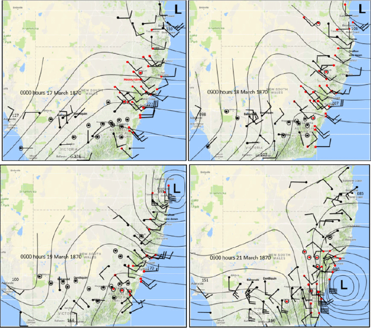
An ECL developed on the North Coast NSW and moved south to Sydney. On 17 and 18 March, a low was developing north-east of Brisbane (top frames of Fig. 7) with rain heavy in places along the coast extending into the Northern Basin of the MDB. The low then intensified and moved to the east of Wollongong (lower frames of Fig. 7) with the heavy rain contracting south into the Murray and Murrumbidgee watersheds.
|
The east coastal effects are described in Callaghan and Power (2014b).
As a result of these two March events, there was major flooding on the Darling Downs Qld and in the Namoi River NSW. There were two fatalities.
5.3 21–27 April 1870
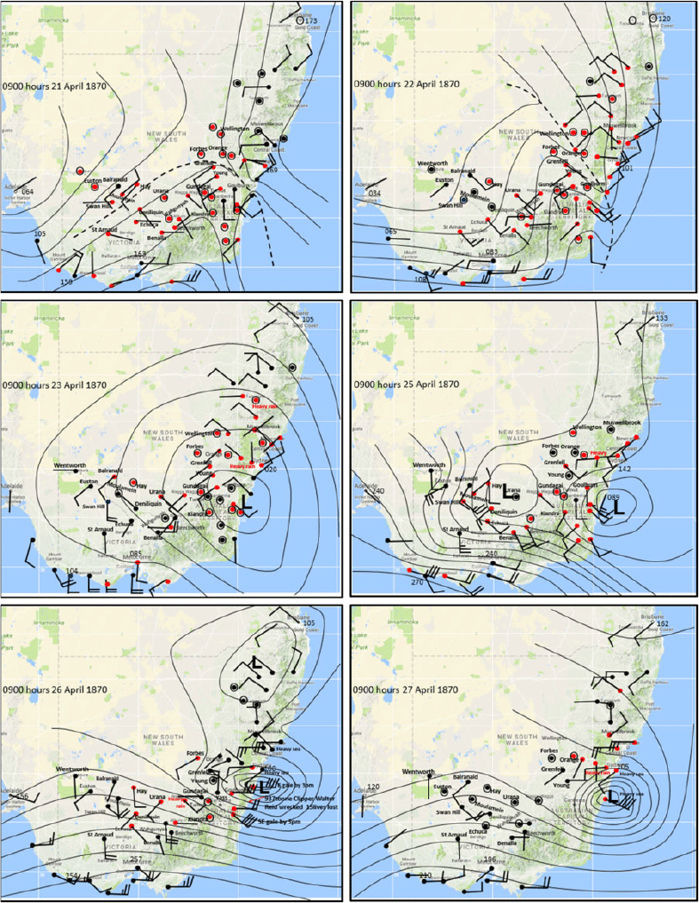
An intense ECL developed near Ulladulla over the 25 and 26 April 1870. An active trough lay through NSW (dashed lines define troughs in the top frames of Fig. 8) from 21 to 22 April 1870 and there were extensive rain areas from observations in the NSW observational network which indicated rainfall into both the Northern and Southern Sections of the MDB. From 23–25 April 1870 a complex low formed (middle frames of Fig. 8) maintaining the extensive rainfall. Over the 26–27 April 1870 the ECL formed (lower frames) with the heavy rainfall focussed on the Riverina districts and the gradually contracting towards the coast.
|
The east coastal effects are described in Callaghan and Power (2014b).
There were six fatalities in the MDB. The ECL caused disastrous flooding in NSW at Brewarrina (90 km east-northeast of Bourke), Burrowa (Lachlan River), Gundaroo (Lake George), Wheeo and Taralga (Lachlan River), Goolagong, Cowra, Grenfell and Forbes (Lachlan), Wagga Wagga, Yass and Gunning (Murrumbidgee), Gunnedah (Namoi River), Dubbo (Macquarie), Coonamble (Castlereagh River), Cox’s Creek area and the Mooki River which flows into the Namoi River. On 22 April 1870 in the Darling River near Bourke two men drowned (from the six mentioned above).
5.4 10–13 May 1870
A low developed near Seal Rocks NSW late on 11 May and moved south to the far NSW South Coast by 13 May. During 10 to 11 May 1870 a complex trough system in south-east Australia produced widespread rain across NSW (top frames of Fig. 9) which became more extensive with heavy rain reported and extended into Vic. by 12 May (lower frames of Fig. 9) as a low formed north of Newcastle. An intense low formed during 13 May bringing flood rains to Vic. and the Riverina however details of the low were unknown due to multiple telegraph lines downed along the NSW South Coast.

|
The east coastal effects are described in Callaghan and Power (2014b).
There was one fatality. Disastrous flooding occurred in NSW at Queanbeyan, Bombala, Bibbenluke (Monaro), Gundagai and Wagga Wagga (Murrumbidgee), Dubbo (Macquarie), Gunnedah (Namoi).
5.5 7–8 September 1870
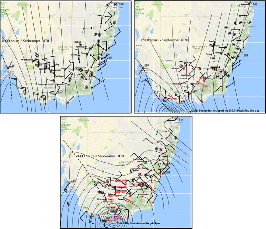
Figure 10 (top frames) shows that during 6 to 7 September 1870 a moist sub-tropical north to north-easterly airstream flowed into south-east Australia ahead of a trough system (dashed line) entering Vic. where heavy rainfall was developing extending up into the Riverina. An intense low developed over Melbourne (lower frame of Fig. 10) and the heavy rain became more widespread. As the 986-hPa low developed just south of Melbourne at 0900 hours (local time) 8 September 1870 barometers were down to 994.7 hPa at Melbourne, Cape Schanck 988.1 hPa and Cape Otway 991.0 hPa.
|
There were 18 fatalities. All-time record floods in the Murray River (see Appendix 1).
5.6 24–30 October 1870
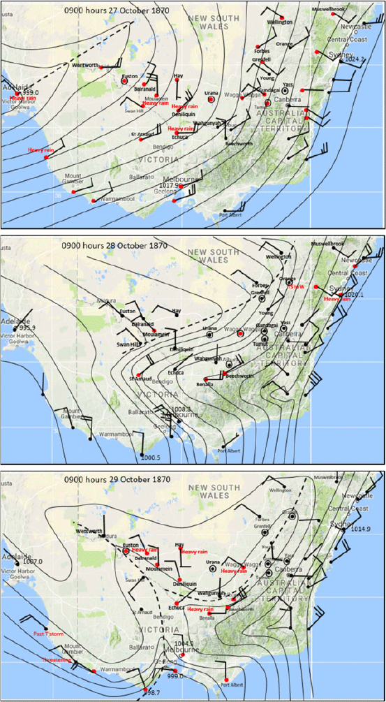
A complex trough system (trough lines depicted by dashed lines) formed over south-east Australia (Fig. 11) and produced widespread rain over NSW and northern Vic. on 24 October 1870 becoming heavy over Vic. on 25 October 1870. By 27 October 1870 (Fig. 12, top frame) a ridge built along the east coast with a trough over western NSW which brought a strong sub-tropical north-east air stream with heavy rain into areas closer to the trough. By 28 October 1870 (Fig. 12, centre frame) the trough moved east contracting rain mostly into Northern Vic. and eastern NSW. Then on 29 October 1870 (Fig. 12, lower frame) the trough interacted with a new trough extending northwards from Bass Strait to produce widespread heavy rain over the Riverina and Vic.

|
|
There was widespread major flooding in Northern and Western Victoria with 20 fatalities (see Appendix 1).
6 Precursor rainfall to the 1870 floods
From available data show in this section, the 1870 flood followed a dry year. At the beginning of 1870 in the Warrego River country in the northern MDB, there were reports of very dry conditions and being devoid of grass. Mounted Police Sergeant J. R. Ewens, officer in charge of the Blanchetown SA police station, wrote in his diary that the 1870 flood began as early as April 1870 when the river was rising and steamers were moving again down the Darling with wool with the implication that the river was not flowing well prior to April 1870.
There is no record of any sustained major flooding in the MDB in 1869. Below are reports from an extensive search in the newspaper archives of the National Library of Australia showing the few such events that threatened flooding in the MDB during 1869:
10 April 1869 – Report of 2 days of rain around Bourke and at Dubbo (NSW), where there was some street flooding reported. At Leyburn (Qld on the Condamine River) floods swamped the watercourse known as Canal Creek in less than 2 h, and much damage was done. At Goondiwindi (Qld on the Macintyre River), the mailman from Mungindi (NSW) reported that the Barwon River had flooded.
On 21 April 1869 at Goondiwindi, the creeks flooded and mails were delayed.
A severe ECL during 8–9 May 1869 produced major flooding in the Hawkesbury and Nepean Rivers near Sydney NSW. In the MDB, there was heavy rain at Queanbeyan and Cooma in NSW but no flooding reports.
A report was received on 1 July 1869 from the Culgoa River, St George (Qld) and Tamworth (NSW) of beneficial flooding following months of dry weather.
During 16–17 October 1869, a front with tropical inflow to the east passed through Vic., where there was heavy rain producing major flooding at Clunes on the Loddon River. Also there was heavy rain in NSW at Wentworth and Urana.
7 The 1870 remaining weather systems and resultant floods
Details of flooding and the weather during 1870 are provided in Appendix 1 and below is a summary of this information. This summary notes the additional weather systems involved for each month followed by a brief mention of the impacts.
7.1 Overview
The Darling River flood peaked at Bourke on 30 May 1870 and at Wilcannia around 20 August 1870. Floods initially peaked at Wentworth on 11 August 1870 and then a second flood arrived (probably from the Murray) on 28 September 1870 and the river kept rising until the end of November 1870. In SA the flood arrived on 30 September 1870 with the peak around 13 December 1870. Full details can be found in Appendix 2.
There were other lesser weather systems which are listed below and these served to add water to the river systems in the MDB, enhancing subsequent flood rains.
7.2 Additional 1970 events to those in Section 5
During January 1870 there were two weather systems that affected the MDB – one produced a flood in the Warrego River.
There were no other floods, but rainfall occurred throughout both Northern and Southern Basins of the MDB.
During February 1870, there was no significant rainfall.
During April 1970, a rainband during 2–5 April 1870 caused flooding at Cooma.
During June 1870, there were three rainbands which crossed NSW during June and were probably associated with upper troughs. The influence of upper troughs in generating heavy rainfall in south-east Australia is discussed in Callaghan and Power (2016). Major floods in NSW resulted at Cannonbar (Macquarie River), Adelong Creek (near Tumut), another at Wagga Wagga, Dubbo (second highest on record), Tumut and the whole country around Wilcannia was flooded.
During July 1870, a weak ECL occurred 10–16 July 1870 and over 21–22 July 1870 a rainband with an upper trough crossed eastern Australia with moderate flooding at Roma and Saint George in the Southeast Interior of Qld.
During August 1870, there were a series of unstable troughs producing thunderstorms. Flooding in the Condamine and Macintyre Rivers in the Darling Downs (Qld) resulted. Inglewood reported one of the greatest floods in the Macintyre for many years.
During September 1870, a rainband over 17–20 September 1870 crossed NSW and Kiandra reported 85.9 mm in 24 h.
On 26 September 1870 at Wentworth, one boy was drowned as the population were about to abandon the town.
During October 1870, over 4–5 October 1870, an area of thunderstorms affected the Darling River District and a rainband crossed NSW during 24–25 October 1870.
The Darling River storms generated 50 mm of rain over 2 days and appeared to be widespread, and the NSW rainband caused flooding at Adelong (near Tumut) and at Young and there was one fatality.
During November 1870, a rainband crossed NSW 11–14 November 1870, an ECL occurred during 16–19 November 1870.
In NSW, a fourth flood occurred at Moulamein, and there was one at Yass and there was a flood in the Condamine at Warwick (Qld).
There were no major weather systems in December 1970.
7.3 Snow
On 5 October 1870, there were reports from the east indicating that there was more snow in the Australian Alps than had ever before been known, which had serious consequences of snowmelt floods.
8 Murray–Darling basin rainfall during 1956 and precursor rainfall to the 1956 floods
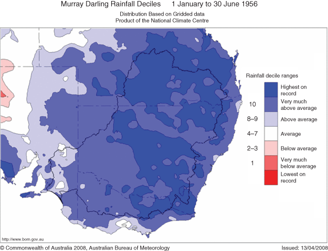
The period from the 1 January 1956 to 30 June 1956 in the MDB the rainfall (Fig. 13) was very much above average to highest on record.
Leading up to the 1956 record MDB rainfall, the period from the 1 January 1955 to 31 December 1955 in the MDB (Fig. 14), the rainfall was mostly above average to very much above average.
During late October 1955, for instance, the Murray River flood peaked 8.3 m at Morgan in SA and pre-empted the 1956 flood.
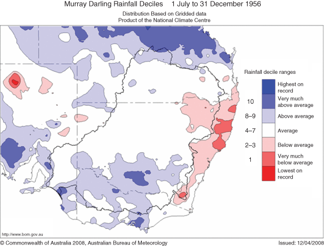
The second half of 1956 the rainfall in the MDB was closer to average (Fig. 15).
This study concentrates on the rainfall from January to July 1956, as during August, the heavy rain ceased with mostly below average rainfall in the Basin.
Full details of flooding and the weather during 1956 is provided in Appendix 1 and below is a summary of this information.
8.1 Overview
Over January and February 1956, four weather systems affected the MDB and these produced floods in Southern Qld, north-east sections of the MDB and in Northern Vic. During March 1956, seven weather systems produced all-time record rainfall and widespread major flooding over much of the MDB. During April and May, seven weather systems caused flooding in smaller areas of Qld, NSW and Vic. Six weather systems during June and July 1956 produced major flooding and some record flooding in the MDB.
The record March rainfall caused the Darling River to flood at Bourke by 22 March 1956, reaching Wilcannia by 26 April 1956 and by 28 May 1956 was 22.5-km wide approaching Wentworth and the Murray River. The combined Murray and Darling Rivers flooded Renmark early June, and by 1 July 1956 the SA section of the Murray was 3.2-km wide. A new flood pulse came down the Murray River to Wentworth on 17 July 1956, whereas the Darling was on the rise again at Bourke reaching 13.61 m on 31 July 1956. The floods peaked at Wentworth on 15 August reaching 9.78 m, Renmark 23 August 10.2 m and a little later at Morgan 12.3 m. The new peak in the Darling reached Menindee on 2 September 1956 (from Harrison 1957) when the gauge there read 10.06 m. The Darling River peak reached Burtundy (50 km north-northeast of Wentworth) on 12 September 1956 as the Murray was dropping.
9 Monthly events in 1956
9.1 January 1956
MDB January 1956 rainfall varied from average to very much above average with a record rainfall area in the Darling Downs.
Over 18–20 January 1956, an active monsoon trough with tropical north-easterly flow into a front took place over south-east Australia.
There were floods in Vic. at Shepparton and Lima South.
During 20–23 January 1956, a tropical low near Mackay had a trough to the south which dominated the rainfall.
There was a record flood in Macintyre Brook at Inglewood, and unprecedented floods were experienced in the Condamine and Macintyre rivers.
9.2 February 1956
MDB February 1956 rainfall – Rainfall in the Northern Basin of the MDB was very much above average with pockets of record rain in the Warrego, in the Namoi and in the eastern Darling Downs.
An inland trough developed over 5–8 February 1956 and formed the ECL of 9–11 February 1956.
The second major system was a rapid intensifying tropical low near Tweed Heads NSW over 17–19 February 1956.
In Qld record floods occurred in the Macintyre and Condamine Rivers. There were also floods in the Balonne and Barwon Rivers. In NSW major flooding occurred in the Macintyre, Namoi and Gwydir Rivers.
9.3 March 1956
Record rainfall March 1956 occurred. The NSW statewide historical March average rainfall was 48.97 mm. The March record was 155.31 mm, which occurred during March 1956.
A low developed 24 February–1 March 1956 near Lord Howe Island and moved towards the coast under the influence of the very large circulation of TC Agnes.
A trough crossed NSW 2–3 March 1956 with a tropical moisture feed in from TC Agnes.
A trough near Adelaide during 5–6 March 1956 developed into a low in the Eastern Great Australian Bight with tropical flow into Victoria from TC Agnes (approaching Townsville). Agnes (named by the media) had a very large circulation which enabled it to bring high tropical moisture into south-east Australia (Callaghan and Smith 1998).
TC Agnes hit Townsville on the 6 March 1956 and heavy rainfall affected southern states as the moisture from Agnes penetrated there and interacted with a major front over 6–9 March 1956. Agnes then moved down to the Western Qld–NSW border by 12 March 1956 and brought heavy rain into the MDB.
Northerly to north-easterly tropical inflow over 13–14 March 1956 flowed into a trough over south-west Qld (ex TC Agnes) and across Southern NSW and Western Vic. This interaction developed into a complex low over Tasmania.
Over 19–20 March 1956 a large high moved into the Tasman Sea with tropical north-east winds and a strong pressure gradient across Southern Qld and NSW.
By 0000 UTC 29 March 1956 an active monsoon trough with an intense low below 990 hPa developing in south-west Qld at 0000 UTC 30 March 1956 ahead of a 500-hPa low. This then merged with a strong surface front through south-west Qld and Western NSW–Vic. by 0000 UTC 1 April 1956.
The following impacts occurred from the above March 1956 weather systems: major flood at Canberra; record rain fell over the Darling River District and Northern Victoria; major floods occurred at Cooma and the second highest flood at Dubbo (with 1870); major floods in the Lachlan, Macquarie and Bogan Rivers affecting Forbes, Warren, Wellington, Cowra, Canowindra, Narromine and Nyngan; major floods at Goodooga (30 km south-west of Hebel) and Brewarrina District (90 km east-northeast of Bourke); extreme rainfall at the end of March led to record Qld floods in early April in the Warrego River at Charleville, Wyandra and Cunnamulla and floods in the Maranoa River.
9.4 April 1956
During April 1956, rainfall in the MDB was mostly average to very much above average with highest on record around north-east Highlands of Vic.
Over 14–16 April 1956, a 982-hPa low was located west of Tasmania and from 16 to 19 April 1956 the low moved slowly to the south of Tasmania.
During 25–26 April 1956, a 1007-hPa low over Central NSW moved east to become a 1000-hPa low east of Coffs Harbour.
Major floods in occurred in Vic. rivers, Avoca, Upper Murray, Ovens and Mitta Mitta.
9.5 May 1956
During May 1956, rainfall in the MDB was mostly above to very much above average with highest on record in Western Victoria and nearby NSW. Also small pockets of highest on record rainfall occurred in south-west and north-east NSW.
A 1000-hPa low developed in Gippsland 1–3 May 1956 and moved east. Ahead of this development, a trough lay from Central Qld to Western Vic. with a north-easterly airstream feeding into it.
An inland low 11–13 May 1956 intensified off the NSW South Coast and moved away.
Over 10–11 May 1956 a 1003-hPa low developed over north-west NSW.
During 13–14 May 1956, a 985-hPa low at south of WA moved into The Great Australian Bight and deepened to 975 hPa on 15 May 1956 and then weakened to 995 hPa on 16 May 1956.
Major floods occurred in NSW at Gunnedah and Wagga Wagga, in Victoria at Rochester on the Campaspe River with an ARI > 100 years at Avoca (one fatality), at Shepparton and Maryborough. In Qld, there was sustained flooding in the lower Balonne and Moonie rivers.
9.6 June 1956
During June 1956 rainfall in the MDB, there was mostly above to very much above average with highest on record around parts of the ACT and nearby.
A 1005-hPa low near Lord Howe Island 9 June 1956 rapidly intensified to below 994 hPa and moved near the coast east of Wollongong in 24 h.
An ECL developed over 24–26 June 1956 with eight fatalities at sea. As it moved from north of Fraser Island to the Gold Coast, it then amalgamated with an inland low to form an intense depression off the South Coast of NSW on 26 June 1956.
Murrumbidgee floods occurred at Gundagai, Wagga Wagga, Narrandera and Darlington Point. Major flood occurred in the Murray River at Albury and in the Molonglo River. Major floods were reported at Coonamble, Dubbo, Forbes and Narromine in the Lachlan River and at Goondiwindi (Qld) on the Macintyre River.
9.7 July 1956
July 1956 rainfall in the MDB was average, grading to very much above average to highest on record west of a line from Tambo (south-west Qld) to the ACT.
Over 6–8 July 1956 a 1010-hPa low near Adelaide with tropical inflow to east, moved to become a 1000-hPa low south-east of Tasmania.
A low deepened and moved from south-west NSW to east of Sydney 11–12 July 1956.
During 16–17 July 1956 a 1000-hPa low south of Ceduna moved near Mt Gambier with heavy rain through Riverina.
During 24–26 July 1956 a 995-hPa low complex south of Adelaide and Melbourne moved into the south-west Tasman Sea with a series of fronts.
Record flood levels reported in the Warrego, Bulloo and Paroo Rivers in Qld. Major flood also were reported at Echuca, Mildura, Shepparton, Albury Wodonga, Wangaratta, Rochester, Charlton, Rodsborough (near Bendigo) and in NSW at Balranald and Deniliquin and in the NSW Murray towns of Wagga Wagga, Barham and Wakool.
10 Conclusion
Over much of the MDB the 1870 flood appears to have had a larger impact than the well-known 1956 flood. This was despite it occurring with dry drought-like conditions at the beginning of 1870, whereas the 1956 flood followed the 1955 MDB flood. In fact one of the worst and deadliest NSW floods (Bond and Wiesner 1955) occurred in February 1955 and affected a large area of the MDB. Three of the events during 1870 were unprecedented. A complex low and trough moved across NSW from 21 April 1870 to form an ECL on 27 April 1870 and deluged much of NSW. Such slow-moving systems tend to produce the most destructive floods. Other examples are the record 1867 Hawkesbury River flood around Sydney and the 1893 Brisbane River flood (Callaghan and Power 2014a) and more recently the Houston (US) 2017 flood associated with Hurricane Harvey (Callaghan 2018). The low-pressure system which impacted on Vic. from 6 to 8 September 1870 was another unprecedented event producing a record flood in the Murray River with an ARI of 150 years. This was quickly followed by a devastating low-pressure trough which caused much loss of life during October 1870. There were record events also in 1956 and the Month of March 1956 produced record rainfall across NSW. This excludes 1870 which appears to have had extreme March 1870 rainfall from the few available observations. TC Agnes played a huge role in generating the large March rainfall in 1956 from its own track inland into the MDB and its interaction with other systems passing to its south.
The Bureau of Meteorology data indicate that rainfall over the MDB over the last century showed the peaks in activity all aligned with negative phases of the IPO. Blocking high pressure–low pressure couplets located near longitude 140° were also shown to favour heavy rain in the MDB which occurred during the latter positive phase of the IPO conflicting with the IPO trend. Persistent and unexplained middle level westerly winds kept subtropical Qld clear of tropical cyclones during the negative phases of the IPO from 1999 to 2009 and during the 1960s influencing low rainfall in the MDB during those periods.
Studies have also shown how weather systems with strong pressure gradients impacting on south-east Australia have been in decline since the latter part of the 19th century and, in the opinion of the authors of those studies, contributing to persistent drought conditions there. Examination of many events have shown that such intense weather systems do not always produce heavy rainfall and that strong weather systems further east from their study area which are associated with flooding rainfall appeared to have increased during the 20th century.
From Bloss et al. (2015) historical events have been analysed using modelling studies to ascertain how they would impact in SA today given the large number of mitigation effects such as dams that have been constructed. In their study, modern basin development (such as dams and irrigation) would not have had a large flood mitigation impact on the 1956 flood. This was the largest event in their time series and it was mitigated only slightly to 93% of the without development flow. There was no data for the 1870 flood but it would probably today result in larger mitigation effect than the 1956 flood due to more flood water being diverted to natural and man-made water storages as a result of the dry precursor conditions. Obviously an 1870-type event following a wet year would be a worst-case scenario.
Acknowledgements
The author acknowledges the effort by the two anonymous reviewers whose suggestions expanded the paper into a more worthwhile description of heavy rainfall in the MDB. This research did not receive any specific funding.
References
Alexander, L., and Power, S. (2009). Severe storms inferred from 150 years of sub-daily pressure observations along Victoria’s “Shipwreck Coast.” Aust. Meteorol. Oceanogr. J. 58, 129–133.| Severe storms inferred from 150 years of sub-daily pressure observations along Victoria’s “Shipwreck Coast.”Crossref | GoogleScholarGoogle Scholar |
Alexander, L. V., Wang, X. L., Wan, H., and Trewin, B. (2011). Significant decline in storminess over southeast Australia since the late 19th century. Aust. Meteorol. Oceanogr. J. 61, 23–30.
| Significant decline in storminess over southeast Australia since the late 19th century.Crossref | GoogleScholarGoogle Scholar |
Bloss, C., Eckert, G., and Cetin, L. (2015). River Murray flood mitigation planning: Assessment of flood consequences. Department of Environment, Water and Natural Resources December, 2015 DEWNR Technical report 2015/56. 41 pp.
Bond, H. G., and Wiesner, C. J. (1955). The floods of February 1955 in New South Wales. Aust. Meteorol. Mag. 1, 1–33.
Callaghan, J. (2018). 2018 Trop. Cyclone Res. Rev. 7, 164.
| 2018Crossref | GoogleScholarGoogle Scholar |
Callaghan, J., and Helman, P. (2008). Severe Storms on the east coast of Australia 1770–2008. (Griffith Centre for Coastal Management, Griffith University Gold Coast Queensland.)
Callaghan, J., and Power, S. B. (2011). Variability and decline in the number of severe tropical 422 cyclones making land-fall over eastern Australia since the late nineteenth century. Clim. Dyn. 37, 647–662.
| Variability and decline in the number of severe tropical 422 cyclones making land-fall over eastern Australia since the late nineteenth century.Crossref | GoogleScholarGoogle Scholar |
Callaghan, J., and Power, S. B. (2014a). Major coastal flooding in south-eastern Australia 1860–2012, associated deaths and weather systems. Aust. Meteorol. Oceanogr. J. 64, 183–213.
| Major coastal flooding in south-eastern Australia 1860–2012, associated deaths and weather systems.Crossref | GoogleScholarGoogle Scholar |
Callaghan, J., and Power, S. B. (2014b). Major coastal flooding in south-eastern Australia 1860–2012, Supplementary appendix – details on severe weather systems over southeast Australia, 1799–2013.
Callaghan, J., and Power, S. B. (2016). A vertical wind structure that leads to extreme rainfall and major flooding in southeast Australia. J. South. Hemisph. Earth Syst. Sci. 66, 380–401.
| A vertical wind structure that leads to extreme rainfall and major flooding in southeast Australia.Crossref | GoogleScholarGoogle Scholar |
Callaghan, J., and Smith, R. (1998). The relationship between maximum surface wind and central pressure in tropical cyclones. Aust. Meteorol. Mag. 47, 191–202.
Dysthe, K. B., and Harbitz, A. (1987). Big waves from polar lows. Tellus 39A, 500–508.
| Big waves from polar lows.Crossref | GoogleScholarGoogle Scholar |
Harrison, B. E. (1957). Report on the Murray River Flood Problem, Murray River Commission, 69 pp.
Henley, B. J., Meehl, G., Power, S. B., Folland, C. K., King, A. D., Brown, J. N., Karoly, D. J., Delage, F., Gallant, A. J. E., Freund, M., and Neukom, R. (2017). Spatial and temporal agreement in climate model simulations of the Interdecadal Pacific Oscillation. Environ. Res. Lett. 12, 044011.
| Spatial and temporal agreement in climate model simulations of the Interdecadal Pacific Oscillation.Crossref | GoogleScholarGoogle Scholar |
Ho, M., Keim, A. S,., and Verdon-Kidd, D. C. (2015). A paleoclimate rainfall reconstruction in the Murray-Darling Basin (MDB), Australia: 2. Assessing hydroclimatic risk using paleoclimate records of wet and dry epochs. Water Resourc. Res. 51, 8380–8396.
| A paleoclimate rainfall reconstruction in the Murray-Darling Basin (MDB), Australia: 2. Assessing hydroclimatic risk using paleoclimate records of wet and dry epochs.Crossref | GoogleScholarGoogle Scholar |
Joubert, P. N. (2005). Some remarks on the 1998 Sydney Hobart Race. Trans. R. Soc. Victoria 117, ix–xviii.
Mills, G. A. (2001). Mesoscale cyclogenesis in reversed shear – the 1998 Sydney to Hobart yacht race storm. Aust. Met. Mag. 50, 29–52.
Power, S., Casey, T., Folland, C., Colman, A., and Mehta, V. (1999). Inter-decadal modulation of the impact of ENSO on Australia. Clim. Dyn. 15, 319–324.
| Inter-decadal modulation of the impact of ENSO on Australia.Crossref | GoogleScholarGoogle Scholar |
Power, S. B., and Callaghan, J. (2015). Variability in severe coastal flooding in south-eastern Australia since the mid-19th century, associated storms and death tolls. J. Appl. Meteorol. Climatol. 55, 1139–1149.
| Variability in severe coastal flooding in south-eastern Australia since the mid-19th century, associated storms and death tolls.Crossref | GoogleScholarGoogle Scholar |
Power, S. B., and Callaghan, J. (2016). The frequency of major flooding in coastal southeast Australia has significantly increased since the late 19th century. J. South. Hemisph. Earth Syst. Sci. 66, 2–11.
| The frequency of major flooding in coastal southeast Australia has significantly increased since the late 19th century.Crossref | GoogleScholarGoogle Scholar |
Risbey, J. S., Pook, M. J., McIntosh, P. C., Wheeler, M. C., and Hendon, H. H. (2009). On the remote drivers of rainfall variability in Australia. Mon. Wea. Rev. 137, 3233–3252.
| On the remote drivers of rainfall variability in Australia.Crossref | GoogleScholarGoogle Scholar |
Speer, M. (2008). On the late twentieth century decrease in Australian east coast rainfall extremes. Atmos. Sci. Lett. 9, 160–170.
| On the late twentieth century decrease in Australian east coast rainfall extremes.Crossref | GoogleScholarGoogle Scholar |
Timbal, B., and Fawcett, R. (2013). A historical perspective on southeastern Australian rainfall since 1865 using the instrumental record. J. Clim. 26, 1112–1129.
| A historical perspective on southeastern Australian rainfall since 1865 using the instrumental record.Crossref | GoogleScholarGoogle Scholar |
Whetton, P. H. (1990). Relationship between monthly anomalies of Australian sea-surface temperature and Victorian rainfall. Aust. Met. Mag. 38, 31–41.
A1.1 Details of impacts during 1870

|
A1.2 Details of impacts during 1956
MDB, Murray–Darling Basin; TCs, tropical cyclones.

|
A2.1 January 1870 events
First weather system – Rainband with heavy areas with thunderstorms, 3–4 January 1870
Rainband affected Warrego with nearest station Roma reporting rain late 3 January through to 4 January. Torrential rain in the Warrego produces the biggest flood in years. Previously the country was very dry and devoid of grass. Same system at Wanganella (148-km south-west Hay): 50.8 mm on 3rd. Rain NSW MDB – 3 January Thunderstorms at Hay, Moulamein, Urana, Deniliquin, Balranald, Euston, Wentworth, Forbes, Dubbo Narrabri and Wagga Wagga. NSW MDB – 4 January – Rain at Tenterfield, Glen Innes, Inverell, Armidale, Tamworth, Gunnedah, Murrurundi, Yass.
Second weather system – Rainband with heavy areas with thunderstorms, 26 January 1870
26 January 1870 – Rain NSW MDB – Wanganella (148-km south-west of Hay): 50.8 mm on 3rd; 63.5 mm on 26th; Forbes, Young, Wellington, Dubbo, Bathurst, Orange, Cooma, Yass, Gundagai, Tumut, Kiandra, Albury, Balranald, Hay, Deniliquin, Urana, Wagga Wagga and Cooma.
27 January 1870 – NSW MDB rain – Gundagai, Yass, Bombala, Cooma, Tumut, Kiandra, Wellington, Dubbo, Bathurst, Orange, Young, Forbes, Tamworth, Murrurundi, Gunnedah, Narrabri and Armidale.
March 1870 events
Tropical cyclone 2–10 March 1870
This was a prolonged period of rainfall with some heavy falls in Queensland and NSW due to tropical air moving over the area as a tropical cyclone moved southwards from 2 to 12 March 1870.
Rainfall reported from tropical cyclone effects.
2 March 1870 – NSW MDB rain – Tenterfield, Narrabri, Armidale, Tamworth, Bathurst, Wellington, Dubbo, Wellington, Forbes, Young, Orange, Urana, Deniliquin, Wagga Wagga, Moulamein, Euston, Hay, Balranald, Wentworth, Hay, Goulburn (heavy rain), Queanbeyan, Bombala, Cooma, Yass and Albury. Qld MRB Rain – Allora, Dalby, Drayton, Roma and Warwick.
3 March 1870 – NSW MDB rain – Glen Innes, Gunnedah, Narrabri, Bathurst and Wellington Orange.
4 March 1870 – NSW MDB Thunderstorms – Glen Innes, Inverell, Armidale, Tamworth, Mudgee, Wellington, Dubbo, Tamworth, Bathurst. Rain – Bombala, Cooma, Kiandra and Yass.
5 March 1870 – NSW MDB rainfall with some thunderstorms – Glen Innes, Inverell, Yass, Wellington, Orange, Dubbo and Young.
6 March 1870 – No data for NSW, Sunday. Qld MDB rain – Allora, Condamine, Dalby, Roma, Taroom and Warwick.
7 March 1870 – NSW MDB rainfall with some thunderstorms – Tenterfield, Glen Innes, Inverell, Narrabri heavy Rain, Armidale and Gunnedah. Qld MDB rain – Allora, Condamine, Dalby and Roma.
8 March 1870 – Qld MDB – Allora, Condamine, Dalby, Warwick and Roma; NSW (see Fig. 1).
9 March 1870 – Qld MDB – Warwick and Roma; NSW (see Fig. 1).
10 March 1870 – Qld MDB – Condamine, Roma; NSW (see Fig. 1).
East coast low 12–18 March 2018
Rainfall reported due to east coast low:
12 March 1870 – NSW MDB rainfall with some thunderstorms – Gunnedah, Inverell, Narrabri, Tamworth, Young (storm) and Goulburn. Boggabri recorded 35.8 mm.
14 March 1870 – NSW MDB rainfall – Tenterfield, Armidale. Qld MRB – Condamine, Dalby, Roma (heavy rain), Warwick and Taroom.
15 March 1870 – NSW MDB rainfall – Tenterfield, Glen Innes Armidale, Inverell, Narrabri, Tamworth and Glen Innes.
16 March 1870 – NSW MDB rainfall – Tenterfield, Glen Innes Armidale, Inverell, Tamworth, Glen Innes, Dubbo, Bathurst, Wellington.
Event 2–6 April rainband with upper trough.
Rainfall reported:
2 April 1870 – NSW MDB rain – Forbes, Wellington.
4 April 1870 – NSW MDB rain – Narrabri, Forbes, Orange, Dubbo, Bathurst, Wellington, Yass, Young, Grenfell and Cooma.
5 April 1870 – NSW MRB Rain – Cooma, Yass, Queanbeyan, Armadale, Glen Innes, Tamworth, Dubbo, Orange, Wellington (heavy rain), Grenfell, Forbes, Cassilis, Bathurst, Grenfell, Kiandra, Gundagai and Cooma. Thunderstorms – Deniliquin, Hay, and Tumut.
6 April 1870 – NSW MRB Rain – Armidale, Glen Innes, Tenterfield, Wellington and Dubbo.
June 1870 events – Rainbands associated with upper troughs – 8–10 June 1870; 16–19 June 1870 and 22–25 June 1870.
First June event rainfall reported:
8–10 June 1870 rainband associated with upper trough no coastal low.
8 June 1870 – NSW MDB rain – Deniliquin, Albury, Tumut, Gundagai, Queanbeyan and Yass.
9 June 1870 – NSW MDB rain – Young, Moulamein, Grenfell, Forbes, Orange, Mudgee, Dubbo, Wellington, Bathurst, Albury, Bombala, Yass and Gundagai.
10 June 1870 – NSW MDB rain Gundagai, Forbes and Moulamein.
Second June event rainfall reported:
16–19 June 1870 rainband associated with upper trough no coastal low.
16 June 1870 – NSW MDB rain – Balranald, Euston, Moulamein, Hay, Deniliquin, Dubbo, Wellington and Glen Innes.
17 June 1870 – NSW MDB rain – Hay, Deniliquin, Urana, Wagga, Grenfell, Young, Forbes, Albury, Tumut, Gundagai, Yass, Goulburn and Bombala.
18 June 1870 – NSW MDB rain – Wagga, Grenfell, Young, Forbes, Orange, Dubbo, Wellington, Mudgee, Bathurst, Tumut, Yass, Goulburn, Armidale, Inverell, Tamworth, Glen Innes and Tenterfield.
Third June event rainfall reported.
22–25 June 1870 rainband associated with upper trough no coastal low.
22 June 1870 – NSW MDB rain – Wellington, Orange, Dubbo, Forbes, Young, Grenfell, Albury, Gundagai, Narrabri, Inverell, Glen Innes, Armidale and Tamworth.
23 June 1870 – NSW MDB rain – Gunnedah.
24 June 1870 – NSW MDB rain – Wagga, Urana, Young, Grenfell, Forbes, Wellington, Orange, Dubbo, Mudgee, Kiandra, Tumut, Gundagai and Yass.
25 June 1870 NSW MDB rain – Orange, Young, Grenfell, Forbes, Narrabri, Gunnedah, Albury and Tumut.
Events July 1870 – Weak east coast low 10–6 June and 21–22 June 1870 rainband with upper trough.
First July event: 10–16 July 1870 development of a weak east coast low.
15 July 1870 – Qld MDB rain – Condamine and Toowoomba. NSW MDB rain – Goulburn, Orange Wellington Merriwa and Thunderstorms Tamworth.
16 July 1870 – Qld MDB rain – Condamine and Roma.
Second July event: 21-22 July 1870 rainband upper trough no surface low.
21 July 1870 – Qld MDB rain – Condamine, Dalby, Toowoomba, Warwick. NSW MDM Rain – Bathurst, Forbes.
22 July 1870 – Qld MDB rain – Condamine, Dalby, Roma, Toowoomba, Warwick. NSW MDB rain – Forbes.
August 1870 events – Series of unstable troughs producing thunderstorms.
12–22 August 1870 rainfall reported.
13 August 1870 – Qld MDB rain – Warwick, Toowoomba.
14 August 1870 – Qld MDB Thunderstorms – Warwick, Toowoomba, Allora rain calm; Durah (between Chinchilla and Mundubbera), Roma.
15 August 1870 – Qld MDB Thunderstorms – Toowoomba and Warwick.
16 August 1870 – Qld MDB Thunderstorms – Toowoomba and Warwick.
17 August 1870 – Qld MDB Thunderstorms – Toowoomba, Warwick and Dalby.
18 August 1870 – Qld MDB Thunderstorms – Dalby and Durah.
19 August 1870 mostly fine; reports west to south-west winds.
22 August 1870 – Qld MDB Thunderstorms – Toowoomba and Warwick.
Rainband September 17–20 September 1870 culminating with Southerly Gale and rain Jervis Bay.
17 September 1870 – NSW MDB rain – Glen Innes, Inverell, Armidale Tamworth, Narrabri, Bombala, Kiandra (snow), Wellington and Orange.
19 September 1870 – NSW MDB rain – Yass, Tumut, Kiandra, Gundagai, Orange, Forbes, Young, Wagga Wagga and Grenfell. Thunderstorm – Goulburn, Bathurst and Blue Mts.
20 September 1870 – No rain MDB and Southerly Gale and rain Jervis Bay.
October rainband events 24–25 October 1870
24 October 1870 – NSW MDB rain – Queanbeyan, Cooma, Tumut, Kiandra, Albury, Gundagai, Wellington, Orange, Grenfell, Forbes, Wagga Wagga, Urana, Deniliquin, Hay, Moulamein and Dubbo.
25 October 1870 – NSW MDB rain – Gundagai. Bathurst, Queanbeyan, Bombala, Kiandra, Cooma, Dubbo, Wellington, Orange, Forbes, Grenfell, Young, Wagga Wagga and Urana.
November rainband events 11–14 November
12 November 1870 – NSW MDB – Rain Euston, Balranald, Moulamein, Wagga Wagga, Young, Grenfell Forbes, Orange, Dubbo, Bathurst, Yass, Tumut, Gundagai and Armidale.
East coast low 16–19 November 1870
16 November 1870 – NSW MDB rain – Tenterfield, Glen Innes, Inverell, Armidale and Blue Mts.
17 November 1870 – NSW MDB rain – Tenterfield, Glen Innes, Inverell, Armidale, Blue Mountains Heavy rain. Qld MDB rain – Roma.
18 November 1870 – NSW MDB rain – Armidale, Tenterfield, Goulburn, Queanbeyan, Bombala, Yass, Gundagai, Tumut, Blue Mountains, Bathurst, Wellington, Orange, Forbes, Grenfell, Young heavy rain and Wagga Wagga. Qld MDB rain – Roma.
19 November 1870 – NSW MDB Thunderstorm – Glen Innes, Inverell. Rain – Armidale Queanbeyan, Kiandra, Blue Mountains heavy rain, Wellington, Dubbo, Orange, Forbes, Young, Moulamein, Balranald, Euston and Wentworth.

