
The Antarctic ozone hole during 2015 and 2016
Matthew B. Tully A , Andrew R. Klekociuk B C J , Paul B. Krummel D , H. Peter Gies E , Simon P. Alexander B C , Paul J. Fraser A , Stuart I. Henderson E , Robyn Schofield F G , Jonathon D. Shanklin H and Kane A. Stone IA Bureau of Meteorology, Melbourne, Vic., Australia.
B Antarctica and the Global System, Australian Antarctic Division, 203 Channel Highway, Kingston, Tas. 7050, Australia.
C Antarctic Climate and Ecosystems Cooperative Research Centre, Hobart, Tas., Australia.
D Climate Science Centre, CSIRO Oceans and Atmosphere, Aspendale, Vic., Australia.
E Australian Radiation Protection and Nuclear Safety Agency, Melbourne, Vic., Australia.
F School of Earth Sciences, University of Melbourne, Melbourne, Vic., Australia.
G ARC Centre of Excellence for Climate System Science, University of New South Wales, Sydney, NSW, Australia.
H British Antarctic Survey, Cambridge, United Kingdom.
I Massachusetts Institute of Technology, Cambridge, MA, United States of America.
J Corresponding author. Email: Andrew.Klekociuk@aad.gov.au
Journal of Southern Hemisphere Earth Systems Science 69(1) 16-28 https://doi.org/10.1071/ES19021
Submitted: 22 January 2018 Accepted: 13 May 2019 Published: 11 June 2020
Journal Compilation © BoM 2019 Open Access CC BY-NC-ND
Abstract
We reviewed the 2015 and 2016 Antarctic ozone holes, making use of a variety of ground-based and space-based measurements of ozone and ultraviolet radiation, supplemented by meteorological reanalyses. The ozone hole of 2015 was one of the most severe on record with respect to maximum area and integrated deficit and was notably long-lasting, with many values above previous extremes in October, November and December. In contrast, all assessed metrics for the 2016 ozone hole were at or below their median values for the 37 ozone holes since 1979 for which adequate satellite observations exist. The 2015 ozone hole was influenced both by very cold conditions and enhanced ozone depletion caused by stratospheric aerosol resulting from the April 2015 volcanic eruption of Calbuco (Chile).
1 Introduction
The Antarctic ozone hole has continued to appear each spring since its first detected appearance in 1979. Although the underlying mechanism of the ozone hole is now considered well understood, recent further work (Douglass et al. 2014; Solomon et al. 2014; Kirner et al. 2015; Solomon et al. 2015; Zhu et al. 2017) has continued to developed the detailed understanding of the formation of polar stratospheric clouds (PSCs), and the relative contribution of the different types of PSCs and chemical processes which lead to chlorine activation, and then prevent chlorine deactivation, during spring. The variability of reactive forms of chlorine inside the vortex from year to year has been identified (Strahan et al. 2014), including that due to quasi-biennial oscillation (QBO)-influenced transport (Strahan et al. 2015). The significant amount of chemical ozone depletion caused by anthropogenic ozone-depleting substances prior to the year 1980 was studied by Langematz et al. (2016), whereas the impact on Antarctic ozone of the eruption of the Chilean volcano Calbuco in April 2015 has also been investigated (Ivy et al. 2017; Stone et al. 2017).
Solomon et al. (2016) used a combination of modelling and observations to claim that a significantly positive trend in September mean ozone of 2.5 ± 1.7 DU/year could be attributed to declining halogen levels, most markedly in the height range between 100 and 50 hPa.
In this paper, we provide a description of the level of Antarctic ozone depletion in 2015 and 2016 and the relationship with prevailing meteorological conditions using a range of Australian data and analyses including measurements and analyses by the Commonwealth Scientific and Industrial Research Organisation (CSIRO) Oceans and Atmosphere unit, ozone measurements made by the Australian Antarctic Division (AAD) and the Bureau of Meteorology (BoM), and Antarctic ultra-violet measurements from the Australian Radiation Protection and Nuclear Safety Agency (ARPANSA) biometer network. Other data from satellite missions and ground-based instruments are also presented. This work complements the analyses of previous Antarctic ozone holes reported by Tully et al. (2008, 2011) and Klekociuk et al. (2011, 2014a, 2014b, 2015), Krummel et al. (2019) and other analyses of Antarctic atmospheric conditions and ozone depletion during 2015 and 2016 provided by the CSIRO (Krummel et al. 2016, 2017; http://www.environment.gov.au/protection/ozone/publications/antarctic-ozone-hole-summary-reports, accessed 21 April 2020), the World Meteorological Organisation (WMO) Antarctic Ozone Bulletins (http://www.wmo.int/pages/prog/arep/gaw/ozone/index.html, accessed 21 April 2020), upper air summaries of the National Climate Data Center (NCDC; http://www.ncdc.noaa.gov/sotc/upper-air, accessed 21 April 2020) and by Weber et al. (2016, 2017; http://www.ncdc.noaa.gov/bams-state-of-the-climate, accessed 21 April 2020).
2 Total column ozone measurements
2.1 Ozone hole metric summary and rankings
As in previous reports in this series, we use total column ozone measurements from satellite instruments to obtain metrics of the Antarctic ozone hole for each year (see Klekociuk et al. (2015) for details). Here we use data processed with the version 8.5 TOMS algorithm from the Total Ozone Mapping Spectrometer (TOMS) series of satellite instruments, the Ozone Monitoring Instrument (OMI) on the Aura satellite and the Ozone Mapping Profiler Suite (OMPS) on the Suomi National Polar-orbiting Partnership satellite.
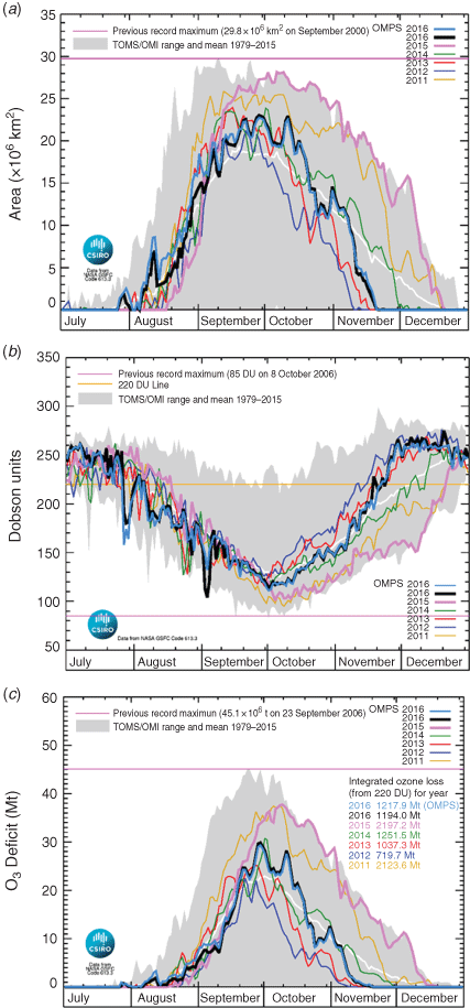
Table 1 contains the ranking for the 37 ozone holes adequately observed by satellite instruments since 1979 using eight metrics that provide different measures of the extent of ozone depletion in each year (see the notes accompanying the table for the definition of each metric). The first seven metrics in Table 1 measure various aspects of the maximum area and depth of the ozone hole. These metrics highlight the contrasting behaviours of the ozone holes of 2015 and 2016. The 2015 ozone hole was ranked between 3rd and 16th in terms of severity across these metrics, with the maximum 15-day averaged area of 27.6 Mkm2 (central date 5 October 2015) equalling the value set in 2006 (central date 22 September 2006) which has only been exceeded by the ozone hole of 2000 (28.7 Mkm2, central date 6 September 2000). Rankings for the metrics relating to minimum ozone values were lower (12th–16th) than those for area (3rd–4th) or deficit (5th–7th). In contrast, the ozone hole of 2016 was ranked between 17th and 21st for all metrics and exhibited quantitative similarity with ozone holes of the late 1980s-early 1990s and some recent years, particularly 2010 and 2014.

|
Figure 1 shows the time-series of the ozone hole area, minimum polar total column ozone and total ozone deficit within the ozone hole over the latter half of each year from 2009 to 2016. Notable features of the metrics shown in Fig. 1 for 2015 are the relatively delayed development of the ozone hole (which started showing significant growth in late August, 1–2 weeks later than most of the years since 2011) and late peak (which occurred in early October, ~2 weeks later than the long-term averages). Furthermore, the metrics during the declining phase were at or near record levels throughout the period from October to mid-December and exhibited relatively little in the way of week-to-week fluctuations that normally occur in this period due to warming of the polar vortex. The date of breakdown (column 8 in Table 1) for 2015 was one of the latest on record.
|
In the case of 2016, the metrics shown in Fig. 1 were more typical of the long-term mean and generally intermediate between the behaviours seen in 2013 and 2014. Notably, there was a rapid decline in the area metric (Fig. 1a) through most of October which gave way to a short hiatus (lasting ~2 weeks up to early November) during which there was slight growth. Subsequently, there was again rapid decline in the size of the hole, and the final breakdown occurred on 20 November, which was similar to the behaviour seen in 2012 and 2013, and generally earlier than the long-term average.
Details of the meteorological conditions in 2015 and 2016 influencing these results are presented in Appendix 1.
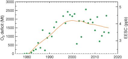
Figure 2 shows the estimated total annual ozone deficit associated with the Antarctic ozone hole. This metric shows large year-to-year variability which largely reflects meteorological factors, with a disturbed polar vortex or relatively warm stratospheric temperatures producing a relatively low deficit, such as for 2002, 2004 and 2012, and cold stratospheric temperatures or a relatively long-lived polar vortex creating a large deficit, such as for 1998–2001 and 2006. The annual deficit in 2015 of 2197 Mt was the 5th largest observed.
|
Also shown in Fig. 2 is the estimated level of Antarctic equivalent effective stratospheric chlorine (EESC; orange line) from Fraser et al. (2014), which is a measure of the potential for ozone depletion in the lower stratosphere.
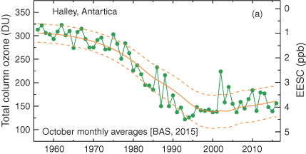
A longer term data record is available from ground-based Dobson spectrophotometer measurements at the British Antarctic Survey’s Halley station (75.6°S and 26.2°W) in Antarctica (BAS 2015). Figure 3 shows mean October total column ozone from 1957 to 2016, again together with Antarctic EESC (Fraser et al. 2014; Klekociuk et al. 2015). The Halley average value for October 2015 shown in Fig. 3 of 139 DU was similar to that measured in years of notably severe ozone loss (Klekociuk et al. 2015); 2000 (137 DU), 2001 (138 DU), 2006 (137 DU) and 2011 (140 DU). The mean October total column ozone value at Halley over 2011–16 (157 ± 18 DU) is higher than that over 1996–2001 (141 ± 4 DU), but the difference is not statistically significant at the 95% confidence threshold (1 standard error in mean values are quoted). Over the years 1996–2016, ignoring the dynamically disturbed years of 2002 and 2004 (Klekociuk et al. 2015), the linear trend is 1.0 ± 1.0 (2σ) DU/year. As studied by Langematz et al. (2016), it is apparent from Fig. 2 that Antarctic ozone depletion was quite significant in the decade from 1970 to 1980 notwithstanding the general use of 1980 as the baseline year for ozone depletion and subsequent recovery.
|
3 Vertically resolved ozone measurements
3.1 Davis ozonesondes
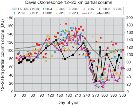
Figure 4 shows the 12–20 km partial column ozone amount for all available ozonesonde measurements from Australia’s Davis research station in Antarctica (68.6°S and 78.0°E). Ozonesonde flights during 2015 were restricted to approximately monthly intervals for most of the year following logistical difficulties in supplying consumables to Davis.
|
The rate of ozone decreases between days 240 and 270 (approximately the month of September) has been quite consistent over the 2003–16 period; however, the minimum value eventually reached, as well as the timing and rate of the following increase, varies significantly from year to year. During the months of October (day-of-year 274–304) and November (day-of-year 305–334), the location of Davis at times can lie outside the ozone hole depending on the size and shape of the hole, leading to the observed spikes in 2015 and more particularly, 2016.
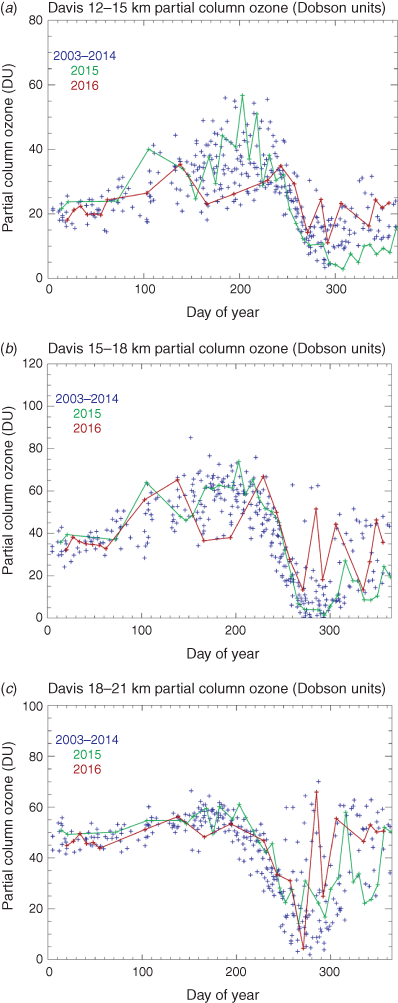
Further detail of the course of depletion in 2015 and 2016 compared to previous years can be seen by breaking down the partial column into the following three narrower height ranges, 12–15, 15–18 and 18–21 km (Fig. 5a–c).
|
The 12–15 km partial column ozone was slightly below the long-term record during the period of decline in September in 2015 and slightly above in 2016; however, the more noteworthy feature was the series of very low values recorded in November and December 2015 after the minimum had been reached, well below those previously seen in the Davis record (2003 onwards). In contrast, in 2016 the 12–15 km partial column was never reduced to the very low ozone values observed in many previous years and recovered steadily.
The 15–18 km partial columns decayed during September somewhat later (10 days) than is typical for the Davis record in both 2015 and 2016, as noted earlier with respect to the area of the ozone hole. Values stayed very low for several weeks in October in 2015 and only slowly recovered. In 2016 this height range showed large variability as the position of Davis relative to the vortex shifted from week to week.
In contrast, the 18–21 km partial column did not display exceptionally low values in 2015, and in fact most other years since 2003 have recorded lower annual minima in this height range. In 2016, a single ozonesonde flight (27 September 2016) measured almost zero ozone (0.23 mPa) at 19.7 km (43 hPa); however, values were much higher after this date for the rest of the year.
The difference in behaviour within the respective partial columns is consistent with the finding of Stone et al. (2017) that the impact on ozone of volcanic aerosol transported polewards from Calbuco (Chile) was concentrated between 150 and 100 hPa (approximately corresponding to 12–15 km in altitude).
3.2 Aura microwave limb sounder stratospheric ozone profiles
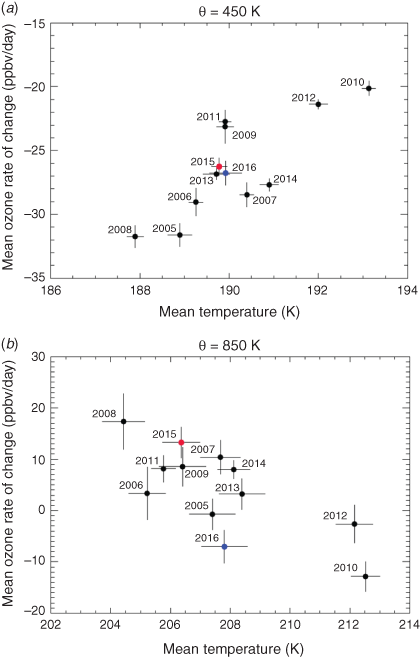
Annual values of the vortex-average rate-of-change of ozone mixing ratio as a function of temperature, averaged over days 200–260 (19 July–17 September in nonleap years), for isentropic levels of potential temperature (θ) equal to 450 K (~18 km height) and θ = 850 K (~31 km height), are shown in Fig. 6a, b, for years 2004–16. These figures essentially summarise characteristics during the period when the ozone hole is generally growing. The values are obtained from Aura microwave limb sounder (MLS) version 4.2 data as described in Appendix 1.
|
Figure 6a shows annual values for the θ = 450 K isentrope. The growth of the ozone hole in the lower stratosphere is primarily influenced by the amount of chemical processing that has taken place within the vortex over the winter (which is enhanced at lower temperatures by greater polar stratospheric cloud volume), and the amount of the vortex that is illuminated by sunlight after the end of the polar night (which depends on the size and symmetry of the vortex). As discussed by Krummel et al. (2019), the amount of chemical processing in the vortex for any given year appears to be a stronger influence on the scatter in Fig. 6a than the amount of illumination received by the vortex during the formation of the ozone hole. There is a general tendency in Fig. 6a for the ozone loss rate to be positively correlated with temperature (Pearson correlation coefficient r = 0.80, significant at the 95% confidence limit), with enhanced ozone loss occurring at lower temperatures. On the θ = 850 K isentrope (Fig 6b), the correlation between the ozone rate-of-change and temperature is negative (r = −0.75, also significant at the 95% confidence limit). At this level, ozone loss is primarily by gas-phase processes which are more efficient at higher temperatures.
Overall, the behaviour of 2015 and 2016 in Fig. 6a, b appears typical in comparison to years in which the polar vortex during late winter and early spring was relatively undisturbed by dynamical activity. This is consistent with the Davis ozonesonde data (Fig. 4) which show the rate of ozone decline in September was fairly typical in both 2015 and 2016, with only subsequent time periods displaying more distinctive behaviour.
3.3 Ozone measurements at Macquarie Island
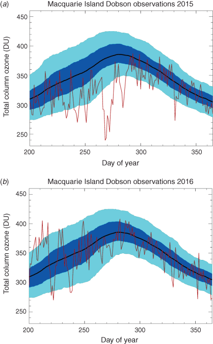
The BoM carries out long-term high-quality measurements of total column ozone at Macquarie Island (54.5°S and 158.9°E) using the Dobson spectrophotometer, continuing a program dating back to 1957. Observations for 2015 and 2016 are shown in red in Fig. 7a, b respectively compared to the 1987–2014 range.
|
In 2015, total column ozone measurements at Macquarie Island were generally below the long-term mean in winter but returned to more typical values from the middle of October (day 285) onwards. A number of episodes of very low ozone values were observed in September, whereas Macquarie Island was in the vicinity of the polar vortex. On 25 September (day 268), the daily average ozone was 239.5 DU with the lowest single Dobson reading (AD-Direct Sun) of 233 DU. Anomalously low ozone was also recorded during this time as far north as Melbourne (284 DU).
A further episode of low ozone (273 DU) was observed on 27 November (day 331) during the break-up of the ozone hole when Macquarie fell under the influence of the distorted polar vortex.
No episodes of high ozone above the climatological range were observed in 2015.
Compared to 2015, the total ozone measured at Macquarie Island stayed much closer to the long-term seasonal cycle in 2016. Two episodes of low ozone were observed though in August when Macquarie Island was influenced by the polar vortex. On 9 August (day 222), a daily average of 269.9 DU was recorded and 282.8 DU on 25 August (day 238). As was the case in 2015, no episodes of high ozone were observed in spring 2016.
3.4 Antarctic ultraviolet radiation
Measurements of biologically effective solar ultraviolet (UV) radiation are made at Casey (66.3°S and 110.5°E), Mawson (67.6°S and 62.9°E) and Davis research stations in Antarctica. Details on the instrumentation and methods used are provided by Tully et al. (2008) and Klekociuk et al. (2015).
Figure 8 shows the September–December mean UV Index for the three stations from 2007 to 2016. The prolonged low values of total column ozone in October and November (Fig. 1b) when the sun is much higher in the sky, resulted in mean UV values being the highest on record at all three stations, exceeding 2010. In 2016, values were significantly lower and broadly consistent with 2013 and 2014. In general, the mean UV values measured each year are strongly rank-correlated with ozone hole breakdown dates as given in column 8 of Table 1, as a longer lasting ozone hole will cause relatively larger UV increases due to the increased solar elevation later in the year.

|
4 Conclusions
We have examined meteorological conditions and ozone concentrations in the Antarctic atmosphere during 2015 and 2016 using a variety of data sources, including meteorological assimilations, satellite remote sensing measurements, and ground-based instruments and ozonesondes.
The ozone hole of 2015 was one of the most severe on record with respect to maximum area and integrated deficit and was notably long-lasting, with many values above previous extremes in October, November and December. This is attributed to a very strong polar vortex, with the 50 hPa Southern Annular Mode (SAM) at record levels from September to November, and very cold polar temperatures throughout winter and spring – exceeding previous (1979–2014) limits at 100 hPa in October and November. In these conditions, increased concentrations of liquid binary sulfate aerosols resulting from the eruption of the Chilean volcano Calbuco were able to greatly extend the area of the ozone hole equatorward.
In contrast, in 2016, September to November polar temperatures were slightly warmer than the long-term mean in September and October, before warming more markedly in November in conjunction with a weak vortex resulting in an early end to the ozone hole. All assessed metrics for the 2016 ozone hole were at or below their median values.
Acknowledgements
We acknowledge the Department of Environment and Energy for the support of this work, and the assistance of the following people: Jeff Ayton and the AAD’s Antarctic Medical Practitioners in collecting the solar UV data, BoM observers for collecting upper air measurements and the expeditioners of the British Antarctic Survey for collecting the Halley measurements. The TOMS, OMI and OMPS data used in this study are provided by the NASA Goddard Space Flight Center, Atmospheric Chemistry & Dynamics Branch, Code 613.3. Aura/MLS data used in this study were acquired as part of the NASA’s Earth–Sun System Division and archived and distributed by the Goddard Earth Sciences (GES) Data and Information Services Center (DISC) Distributed Active Archive Center (DAAC). UKMO data were obtained from the British Atmospheric Data Centre (http://badc.nerc.ac.uk, accessed 22 April 2020). NCEP Reanalysis-2 data were obtained from the National Oceanic and Atmospheric Administration Earth System Research laboratory, Physical Sciences Division. Part of this work was performed under Project 4293 of the Australian Antarctic Science programme. This research did not receive any specific grant funding.
References
Baldwin, M. P., and Dunkerton, T. J. (1998). Quasi-biennial modulations of the Southern Hemisphere stratospheric polar vortex. Geophys. Res. Lett. 25, 3343–3346.| Quasi-biennial modulations of the Southern Hemisphere stratospheric polar vortex.Crossref | GoogleScholarGoogle Scholar |
BAS (British Antarctic Survey) (2015). Provisional Monthly Mean Ozone Values for Halley [online]. Available at http://www.antarctica.ac.uk/met/jds/ozone/data/ZOZ5699.DAT [Verified 28 November 2015].
Douglass, A. R., Newman, P. A., and Solomon, S. (2014). The Antarctic ozone hole: an update. Phys. Today 67, 42–48.
| The Antarctic ozone hole: an update.Crossref | GoogleScholarGoogle Scholar |
Fortuin, J. P. F., and Kelder, H. (1998). An ozone climatology based on ozonesonde and satellite measurements. J. Geophys. Res. 103, 31709–31734.
| An ozone climatology based on ozonesonde and satellite measurements.Crossref | GoogleScholarGoogle Scholar |
Fraser, P., Krummel, P., Steele, P., Trudinger, C., Etheridge, D., Derek, D., O’Doherty, S., Simmonds, P., Miller, B., Muhle, J., Weiss, R., Oram, D., Prinn, R., and Wang R. (2014). Equivalent effective stratospheric chlorine from Cape Grim Air Archive, Antarctic firn and AGAGE global measurements of ozone depleting substances. In ‘Baseline Atmospheric Program (Australia) 2009–2010’. (Eds N. Derek, P. Krummel, and S. Cleland.) pp. 17–23. (Australian Bureau of Meteorology and CSIRO Marine and Atmospheric Research: Melbourne, Vic., Australia.)
Ivy, D. J., Solomon, S., Kinnison, D., Mills, M. J., Schmidt, A., and Neely, R. R. (2017). The influence of the Calbuco eruption on the 2015 Antarctic ozone hole in a fully coupled chemistry-climate model. Geophys. Res. Lett. 44, 2556–2561.
| The influence of the Calbuco eruption on the 2015 Antarctic ozone hole in a fully coupled chemistry-climate model.Crossref | GoogleScholarGoogle Scholar |
Kanamitsu, M., Ebisuzaki, W., Woollen, J., Yang, S.-K., Hnilo, J. J., Fiorino, M., and Potter, G. L. (2002). NCEP-DEO AMIP-II reanalysis (R-2). Bull. Am. Met. Soc. 83, 1631–1643.
| NCEP-DEO AMIP-II reanalysis (R-2).Crossref | GoogleScholarGoogle Scholar |
Kirner, O., Müller, R., Ruhnke, R., and Fischer, H. (2015). Contribution of liquid, NAT and ice particles to chlorine activation and ozone depletion in Antarctic winter and spring. Atmos. Chem. Phys. 15, 2019–2030.
| Contribution of liquid, NAT and ice particles to chlorine activation and ozone depletion in Antarctic winter and spring.Crossref | GoogleScholarGoogle Scholar |
Klekociuk, A. R., Tully, M. B., Alexander, S. P., Dargaville, R. J., Deschamps, L. L., Fraser, P. J., Gies, H. P., Henderson, S. I., Javorniczky, J., Krummel, P. B., Petelina, S. V., Shanklin, J. D., Siddaway, J. M., and Stone, K. A. (2011). The Antarctic Ozone hole during 2010. Aust. Met. Oceanog. J. 61, 253–267.
| The Antarctic Ozone hole during 2010.Crossref | GoogleScholarGoogle Scholar |
Klekociuk, A. R., Tully, M. B., Krummel, P. B., Gies, H. P., Petelina, S. V., Alexander, S. P., Deschamps, L. L., Fraser, P. J., Henderson, S. I., Javorniczky, J., Shanklin, J. D., Siddaway, J. M., and Stone, K. A. (2014a). The Antarctic ozone hole during 2011. Aust. Met. Oceanog. J. 64, 293–311.
| The Antarctic ozone hole during 2011.Crossref | GoogleScholarGoogle Scholar |
Klekociuk, A. R., Tully, M. B., Krummel, P. B., Gies, H. P., Alexander, S. P., Fraser, P. J., Henderson, S. I., Javorniczky, J., Petelina, S. V., Shanklin, J. D., Schofield, R., and Stone, K. A. (2014b). The Antarctic ozone hole during 2012. Aust. Met. Oceanog. J. 64, 313–330.
| The Antarctic ozone hole during 2012.Crossref | GoogleScholarGoogle Scholar |
Klekociuk, A. R., Tully, M. B., Krummel, P. B., Gies, H. P., Alexander, S. P., Fraser, P. J., Henderson, S. I., Javorniczky, J., Shanklin, J. D., Schofield, R., and Stone, K. A. (2015). The Antarctic ozone hole during 2013. Aust. Met. Oceanog. J. 65, 247–266.
| The Antarctic ozone hole during 2013.Crossref | GoogleScholarGoogle Scholar |
Krummel, P. B., Fraser, P. J. and Derek, N. (2016). The 2015 Antarctic ozone hole and ozone science summary: final report. (Report prepared for the Australian Government Department of the Environment, CSIRO: Australia.) iv, 27 pp. Available at http://www.environment.gov.au/protection/ozone/publications/antarctic-ozone-hole-summary-reports [Verified 21 April 2020].
Krummel, P. B., Fraser P. J. and Derek, N. (2017). The 2016 Antarctic ozone hole summary: final report. (Report prepared for the Australian Government Department of the Environment and Energy, CSIRO: Australia.) v, 28 pp. Available at http://www.environment.gov.au/protection/ozone/publications/antarctic-ozone-hole-summary-reports [Verified 21 April 2020].
Krummel, P. B., Klekociuk, A. R., Tully, M. B., Gies, H. P., Alexander, S. P., Fraser, P. J., Henderson, S. I., Schofield, R., Shanklin, J. D., and Stone, K. A. (2019). ozone hole during 2014. J. South. Hemisph. Earth Syst. Sci. 69, 1–15.
| ozone hole during 2014.Crossref | GoogleScholarGoogle Scholar |
Langematz, U., Schmidt, F., Kunze, M., Bodeker, G. E., and Braesicke, P. (2016). Antarctic ozone depletion between 1960 and 1980 in observations and chemistry–climate model simulations. Atmos. Chem. Phys. 16, 15619–15627.
| Antarctic ozone depletion between 1960 and 1980 in observations and chemistry–climate model simulations.Crossref | GoogleScholarGoogle Scholar |
Manney, G. L., Daffer, W. H., Zawodny, J. M., Bernath, P. F., Hoppel, K. W., Walker, K. A., Knosp, B. W., Boone, C., Remsberg, E. E., Santee, M. L., Harvey, V. L., Pawson, S., Jackson, D. R., Deaver, L., McElroy, C. T., McLinden, C. A., Drummond, J. R., Pumphrey, H. C., Lambert, A., Schwartz, M. J., Froidevaux, L., McLeod, S., Takacs, L. L., Suarez, M. J., Trepte, C. R., Cuddy, D. C., Livesey, N. J., Harwood, R. S., and Waters, (2007). Solar occultation satellite data and derived meteorological products: Sampling issues and comparisons with Aura Microwave Limb Sounder. J. Geophys. Res. 112, D24S50.
| Solar occultation satellite data and derived meteorological products: Sampling issues and comparisons with Aura Microwave Limb Sounder.Crossref | GoogleScholarGoogle Scholar |
Marshall, G. J. (2003). Trends in the Southern Annular Mode from observations and reanalyses. J. Clim. 16, 4134–4143.
| Trends in the Southern Annular Mode from observations and reanalyses.Crossref | GoogleScholarGoogle Scholar |
Nash, E. R., Newman, P. A., Rosenfield, J. E., and Schoeberl, M. R. (1996). An objective determination of the polar vortex using Ertel’s potential vorticity. J. Geophys. Res. 101, 9471–9478.
| An objective determination of the polar vortex using Ertel’s potential vorticity.Crossref | GoogleScholarGoogle Scholar |
Schwartz, M. J., Lambert, A., Manney, G. L., Read, W. G., Livesey, N. J., Froidevaux, L., Ao, C. O., Bernath, P. F., Boone, C. D., Cofield, R. E., Daffer, W. H., Drouin, B. J., Fetzer, E. J., Fuller, R. A., Jarnot, R. F., Jiang, J. H., Jiang, Y. B., Knosp, B. W., Krüger, K. R., Li, J.-L. F., Mlynczak, M. G., Pawson, S., Russell, J. M., Santee, M. L., Snyder, W. V., Stek, P. C., Thurstans, R. P., Tompkins, A. M., Wagner, P. A., Walker, K. A., Waters, J. W., and Wu, D. L. (2008). Validation of the Aura Microwave Limb Sounder temperature and geopotential height measurements. J. Geophys. Res. 113, D15S11.
| Validation of the Aura Microwave Limb Sounder temperature and geopotential height measurements.Crossref | GoogleScholarGoogle Scholar |
Solomon, S., Haskins, J., Ivy, D. J., and Min, F. (2014). Fundamental differences between Arctic and Antarctic ozone depletion. Proc. Natl. Acad. Sci. USA 111, 6220–6225.
| Fundamental differences between Arctic and Antarctic ozone depletion.Crossref | GoogleScholarGoogle Scholar |
Solomon, S., Kinnison, D., Bandoro, J., and Garcia, R. (2015). Simulation of polar ozone depletion: an update. J. Geophys. Res. Atmos 120, 7958–7974.
| Simulation of polar ozone depletion: an update.Crossref | GoogleScholarGoogle Scholar |
Solomon, S., Ivy, D. J., Kinnison, D., Mills, M. J., Neely, R. R., and Schmidt, A. (2016). Emergence of healing in the Antarctic ozone layer. Science 252, 269–274.
| Emergence of healing in the Antarctic ozone layer.Crossref | GoogleScholarGoogle Scholar |
Stone, K. A., Solomon, S., Kinnison, D. E., Pitts, M. C., Poole, L. R., Mills, M. J., Schmidt, A., Neely, R. R., Ivy, D., Schwartz, M. J., Vernier, J.-P., Johnson, B. J., Tully, M. B., Klekociuk, A. R., König-Langlo, G., and Hagiya, S. (2017). the impact of Calbuco volcanic aerosols on South Polar ozone depletion in 2015. J. Geophys. Res. 122, 11862–11879.
| the impact of Calbuco volcanic aerosols on South Polar ozone depletion in 2015.Crossref | GoogleScholarGoogle Scholar |
Strahan, S. E., Douglass, A. R., Newman, P. A., and Steenrod, S. D. (2014). Inorganic chlorine variability in the Antarctic vortex and implications for ozone recovery. J. Geophys. Res. Atmos. 119, 14098–14109.
| Inorganic chlorine variability in the Antarctic vortex and implications for ozone recovery.Crossref | GoogleScholarGoogle Scholar |
Strahan, S. E., Oman, L. D., Douglass, A. R., and Coy, L. (2015). Modulation of Antarctic vortex composition by the quasi-biennial oscillation. Geophys. Res. Lett. 42, 4216–4223.
| Modulation of Antarctic vortex composition by the quasi-biennial oscillation.Crossref | GoogleScholarGoogle Scholar |
Swinbank, R., and O’Neill, A. A. (1994). Stratosphere-troposphere data assimilation system. Mon. Wea. Rev. 122, 686–702.
| Stratosphere-troposphere data assimilation system.Crossref | GoogleScholarGoogle Scholar |
Tully, M. B., Klekociuk, A. R., Deschamps, L. L., Henderson, S. I., Krummel, P. B., Fraser, P. J., Shanklin, J. D., Downey, A. H., Gies, H. P., and Javorniczky, J. (2008). The 2007 Antarctic ozone hole. Aust. Met. Mag. 57, 279–298.
Tully, M. B., Klekociuk, A. R., Alexander, S. P., Dargaville, R. J., Deschamps, L. L., Fraser, P. J., Gies, H. P., Henderson, S. I., Javorniczky, J., Krummel, P. B., Petelina, S. V., Shanklin, J. D., Siddaway, J. M., and Stone, K. A. (2011). The Antarctic ozone hole during 2008 and 2009. Aust. Met. Oceanog. J. 61, 77–90.
| The Antarctic ozone hole during 2008 and 2009.Crossref | GoogleScholarGoogle Scholar |
Watson, P. A. G., and Gray, L. G. (2014). How does the Quasi-Biennial Oscillation affect the stratospheric polar vortex. J. Atmos. Sci. 71, 391–409.
| How does the Quasi-Biennial Oscillation affect the stratospheric polar vortex.Crossref | GoogleScholarGoogle Scholar |
Weber, M., Steinbrecht, W., Roth, C., Coldewey-Egbers, M., Degenstein, D., Fioletov, Y. E., Frith, S. M., Froidevaux, L., de Laat, J., Long, C. S., Loyola, D., and Wild, J. D. (2016). Stratospheric Ozone [in “State of the Climate in 2015”]. Bull. Am. Meteor. Soc. 97, S49–S51.
Weber, M., Steinbrecht, W., Frith, S. M., Tweedy, O., Coldewey-Egbers, M., Davis, S., Degenstein, D., Fioletov, Y. E., Froidevaux, L., de Laat, J., Long, C. S., Loyola, D., Roth, C., and Wild, J. D. (2017). Stratospheric ozone [in “State of the Climate in 2016”]. Bull. Am. Meteor. Soc. 98, S49–S51.
| Stratospheric ozone [in “State of the Climate in 2016”].Crossref | GoogleScholarGoogle Scholar |
Zhu, Y., Toon, O. B., Pitts, M. C., Lambert, A., Bardeen, C., and Kinnison, D. E. (2017). Comparing simulated PSC optical properties with CALIPSO observations during the 2010 Antarctic winter. J. Geophys. Res. Atmos. 122, 1175–1202.
| Comparing simulated PSC optical properties with CALIPSO observations during the 2010 Antarctic winter.Crossref | GoogleScholarGoogle Scholar |
Supplementary information
A1.1 Polar temperatures and atmospheric indices
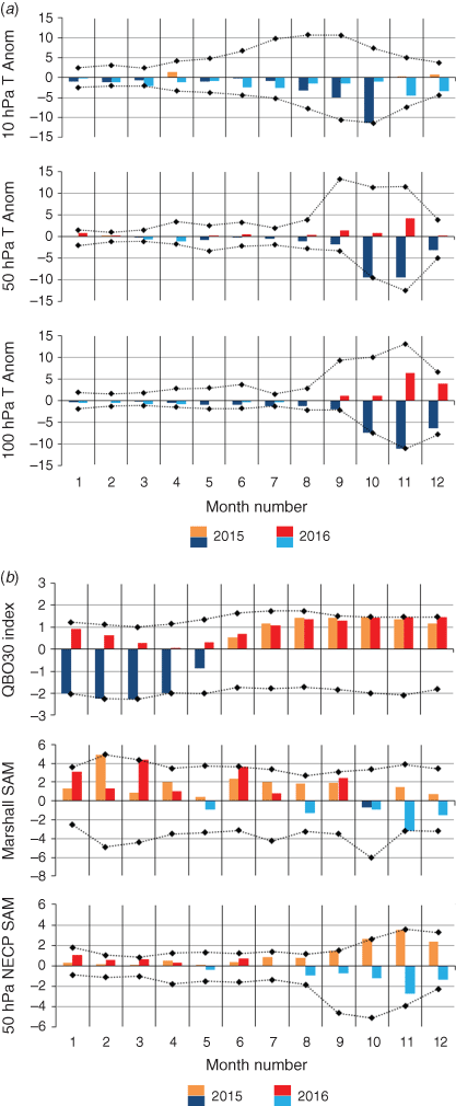
Figure A1.1a shows monthly mean temperature anomalies for the latitude range 90–65°S from the National Centers for Environmental Prediction (NCEP) Reanalysis-2 data (Kanamitsu et al. 2002) with respect to the base period 1979–2014 for three pressure levels. Temperatures in winter were only slightly below the long-term base period mean but become more anomalously cold in September and particularly October, continuing on into November in the lower levels (50 and 100 hPa). In 2016, the 50 and 100 hPa temperatures were only slightly above the long-term mean but were more markedly warmer in November. The 10 hPa temperatures remained slightly below the mean throughout 2016.
|
The NCEP standardised 30 hPa quasi-biennial oscillation (QBO) index (http://www.cpc.ncep.noaa.gov/data/indices/qbo.u30.index, accessed 21 April 2020) is shown in the top panel of Fig. A1.1b. The QBO modulates the ability of upward propagating planetary waves to influence extratropical latitudes in the winter hemisphere, and the strongly negative phase observed in the first 4 months of 2015, favoured a stronger and less disturbed polar vortex (Baldwin and Dunkerton 1998; Watson and Gray 2014). The phase of the QBO shifted to positive in June 2015 but then, in an unprecedented disruption, remained positive in mid-2016 rather than transitioning to negative.
The middle and lower panels of Fig. A1.1b show version of the Southern Annular Mode (SAM) index, defined respectively for the surface (Marshall 2003; http://www.antarctica.ac.uk/met/gjma/sam.html, accessed 21 April 2020) and the stratosphere 50 hPa values evaluated using empirical orthogonal function analysis of NCEP Reanalysis-2 data, following the approach used by the NOAA Climate Prediction Center for their 700 hPa Antarctic Oscillation index (http://www.cpc.ncep.noaa.gov/products/precip/CWlink/daily_ao_index/aao/aao_index.html, accessed 21 April 2020). See Klekociuk et al. (2015) for a discussion of the significance of SAM index values in relation to tropospheric and stratospheric wave dynamics.
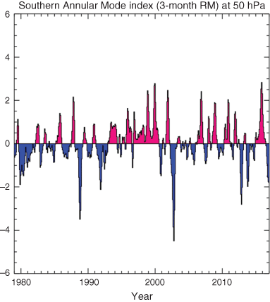
In line with the polar temperature, the 50 hPa SAM was at the highest level recorded in September, October and November 2015 but was below the long-term mean in spring 2016, particularly in November. The extreme strength of the stratospheric SAM in 2016 is further emphasised in Fig. A1.2 in which the value of the 3-month running mean for 50 hPa was the highest on record.
|
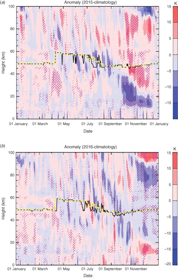
Daily temperature anomalies averaged over the Antarctic region obtained from measurements by the MLS on the Aura spacecraft (Schwartz et al. 2008) are shown for 2015 and 2016 in Fig. A1.3. In 2015, the extreme cold temperatures in October persisted into November and December in the lower stratosphere, but the upper stratosphere was warm from mid-November onwards.
|
A1.2 Dynamical activity
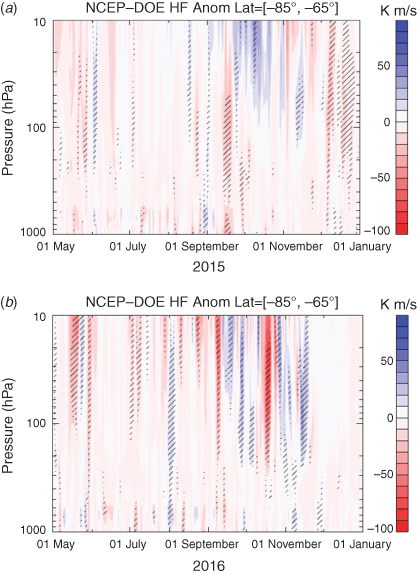
The poleward transport of heat provides a useful indicator of dynamical disturbances to the polar atmosphere produced by planetary waves at low and mid-latitudes. Fig. A1.4 shows the evolution of heat flux (measured by the product of the zonal anomalies in temperature and meridional wind speed) in the polar cap region during 2015 and 2016 using assimilated meteorological data from the United Kingdom Meteorological Office (UKMO).
|
In 2015, the heat flux was at or below mean levels between 10 and 100 hPa for most of the period of July to November, the accumulated result of which led to a markedly undisturbed vortex. One modest warming event is evident in mid-September in the lower stratosphere.
In 2016, two pronounced warming events were evident in early September and again in late October, the latter of which resulted in a decrease in the ozone hole area and warm temperatures from that time on. Wave activity was distinctly below the long-term mean for a brief period around the beginning of October.
A1.3 The polar vortex
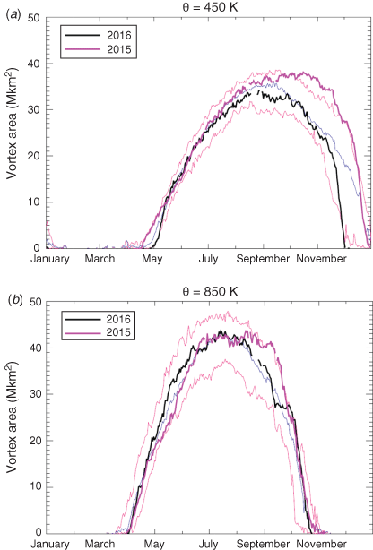
Time-series of proxies for the areal extent of the stratospheric polar vortex are shown in Fig. A1.5 for the θ = 450 K and θ = 850 K isentropic surfaces. At the θ = 450 K level the size of the 2015 vortex departed markedly from the long-term mean in late September and exceeded the previous maximum in October and November. The 2016 vortex at the same level was of typical size in winter but was somewhat smaller in September and dissipated abruptly at the end of November. The size of the vortex at θ = 850 K in both years was mostly close to the long-term mean, except for a period in September and early October when the size was close to the maximum of the base period. As seen in Fig. A1.3, the cold conditions in 2015 only persisted in October and November in the lower stratosphere.
|
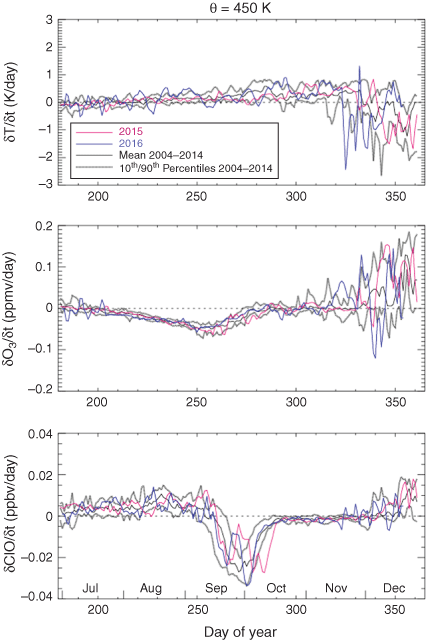
Daily time-series of vortex-average time-derivatives of temperature, ozone mixing ratio and chlorine monoxide (ClO) mixing ratio for isentropic levels of θ = 450 K (~18 km height) and θ = 850 K (~31 km height) are shown for 2015 in Fig. A1.6a, b respectively along with climatological means and percentiles. The time-series are constructed using soundings from the Aura MLS, and estimates of the vortex edge location are derived from the MERRA-2 meteorological reanalysis (Manney et al. 2007). As discussed by Manney et al. (2007), location of the vortex edge can be problematic, particularly outside of winter in the lower stratosphere, and no account has been made here for biases introduced by incorrect diagnosis of the vortex position.
|