
On the recent hiatus of tropical cyclones landfalling in NSW, Australia
J. L. Gray A B D , D. C. Verdon-Kidd B , J. Callaghan C and N. B. English AA School of Health, Medical and Applied Sciences, Central Queensland University, Townsville, Queensland 4810, Australia.
B School of Environmental and Life Sciences, University of Newcastle, Callaghan, New South Wales 2308, Australia.
C Retired. Formerly of Bureau of Meteorology, Queensland Office, Brisbane, Queensland, Australia.
D Corresponding author. Email: j.gray2@cqu.edu.au
Journal of Southern Hemisphere Earth Systems Science 70(1) 180-192 https://doi.org/10.1071/ES19034
Submitted: 5 November 2019 Accepted: 27 March 2020 Published: 2 September 2020
Journal Compilation © BoM 2020 Open Access CC BY-NC-ND
Abstract
It is well known that severe storms result in some of the costliest natural disasters for New South Wales (NSW), Australia. However, it is not widely acknowledged that some of these events are, in fact, a result of landfalling tropical cyclones (TCs). Indeed, the intense focus of TC research within the tropics generally disregards landfalling TC events in the mid-latitude regions of Australia. This is likely due to the perceived infrequency of these events compared to other more susceptible regions. Therefore, in this study, we review this assumption by developing a 150-year record of TC activity, based on a range of digitised and analogue historical datasets and identify 30 individual landfalling TCs that have impacted NSW. Periods of enhanced and reduced TC activity are observed, with a defined hiatus (absence of landfalling TCs) after approximately 1980. The recent decrease in TC activity is subsequently linked to an increase in El Niño activity and warming of north-west Australian sea-surface temperatures during this time. Importantly, it is possible that a return to enhanced TC activity could occur again in the future if the Pacific conditions align. We also propose that pre-instrumental data on TC activity need to be developed to appropriately quantify TC risk for the study region via the development of local palaeoclimate archives. This study provides a significant contribution to understanding the risks of NSW landfalling TCs and expands upon our knowledge of environmental conditions that influence landfalling TCs in NSW.
Keywords: Australia, El Niño, hiatus, Interdecadal Pacific Oscillation (IPO), La Niña, landfall, New South Wales, palaeoclimate, Southern Oscillation Index (SOI), tropical cyclones (TCs).
1 Introduction
On average, 11 tropical cyclones (TCs) occur each year within the Australian region, with four of these events typically making landfall (Dowdy 2014). Although the majority make landfall over Queensland (Qld), the Northern Territory (NT) or Western Australia (WA), TCs have been known to cross into New South Wales (NSW). Although infrequent, when they do occur, the negative environmental, economic and social impacts are substantial, accounting for 7% of the AU$3.2 billion in economic costs of natural disasters in NSW between 2006 and 2017 (SES 2018).
1.1 Tropical cyclone impacts in NSW
Impacts of TCs are a direct result of extreme winds (125–280 km/h), intense rainfall, storm surges and the secondary effects of flooding and coastal erosion (BOM 2018). These extreme meteorological and hydrological conditions result in ship groundings, interruption to community services, property damage, loss of life, disruption to aquatic ecosystems and enhanced erosional processes in coastal and some inland areas of NSW (Potter and Coleman 2003; Forino et al. 2017; Hoque et al. 2017; BOM 2018).
Economic losses from TC events are a prime concern for urbanised coastal communities, governments and industry. A study completed by Forino et al. (2017) found that climate-related hazards account for 90% of insured losses in NSW. Damage costs to infrastructure, property and tourism are the result of heavy winds, flooding and severe inundation generated via storm surge (Potter and Coleman 2003; Sewell et al. 2016; Forino et al. 2017). Social revenues, such as public health and wellbeing, are impacted negatively by TC events within NSW (Forino et al. 2017).
Ex-TC Oswald (January 2013) illustrates the degree of destruction possible from TC events in NSW. Ex-TC Oswald impacted both Qld and NSW, resulting in six deaths, the evacuation of over 2000 people, a power outage of more than 283 000 properties, and the closure of 200 schools (AIDR 2018b). In total, an estimated AU$171 million in government disaster-recovery payments were needed, amounting to AU$121 million in insurance and damages costs in NSW. Similarly, TC Nancy (February 1990) resulted in AU$197 million in damages making landfall in Byron Bay, NSW, and generating 530 mm of rain in a 24-h period, with a wind speed of 60–70 knots (~111–130 km/h) and six fatalities (AIDR 2018a). It is likely that, with continued population and infrastructure expansion, future storms similar to ex-TC Oswald and TC Nancy will produce even greater damage. It is important to accurately know the past frequency of such events before attempting to forecast future changes in the frequency of landfalling cyclones in NSW. A significant impediment to accurately estimating the frequency of past landfalling cyclones in NSW is that existing databases cover very short periods and are therefore not extensive enough to place recent trends into a long-term context.
1.2 Drivers of TCs
A TC develops when favourable environmental conditions exist simultaneously. For example, formation over the ocean requires sea-surface temperature (SST) of 26.5°C or greater, relative humidity (RH) of 40% at 700 hPa and evaporation within the first 50 m of the ocean (McBride and Holland 1987; Terry 2007; Ramsay et al. 2008; Magee et al. 2017). In addition, low vertical wind shear (200 and 850 hPa) provides ideal conditions for TC genesis, as it supplies small variation in wind patterns which allows for enhanced convection and cloud formation (Terry 2007). Previous research has focused on identifying both spatial and temporal relationships between large-scale climate models and TCs in the wider Australian region (Hall et al. 2002; Terry 2007; Callaghan and Power 2011; Liu and Chan 2012; Woodruff et al. 2013; Jin et al. 2014; Diamond and Renwick 2015; Ramsay et al. 2008, 2017). On a seasonal to multi-annual timescale these environmental parameters are modulated by large-scale coupled ocean–atmosphere phenomena, El Niño/Southern Oscillation (ENSO), ENSO Modoki, the Interdecadal Pacific Oscillation (IPO), Madden–Julian Oscillation (MJO) and the Indian Ocean Dipole (IOD). In particular, previous research has shown that more TCs tend to make landfall along the Australian east coast during the La Niña phase of ENSO (Hall et al. 2002; Terry 2007; Ramsay et al. 2008; Callaghan and Power 2011; Woodruff et al. 2013; Jin et al. 2014). Regional studies focusing on the wider Southwest Pacific have shown an interconnected relationship of TC genesis with ENSO and IPO co-occurrence, inferring IPO to be an important driver of TC genesis (Grant and Walsh 2001; Magee et al. 2017). However, to date, specific research on drivers of NSW TCs has not been conducted. Understanding what conditions result in increased TC risk is an important factor in forecasting TCs (on a daily through to seasonal basis) and projecting future changes.
1.3 Research aims
There is ambiguity in the historical TC activity and landfall record, and this is especially the case in NSW. Although a comprehensive landfalling TC study was carried out by Callaghan and Power (2011) for both NSW and Qld, this study did not analyse the full TC track from genesis to decay. Therefore, our study builds upon Callaghan and Power (2011) to identify the relationship between the interannual and interdecadal oscillation of NSW landfalling TCs over their life cycle to demonstrate the potential likelihood of TC impacts on NSW.
A review of TC literature specific to NSW (and Australia-wide) highlights that there (i) is no collated database that targets landfalling TCs within NSW, (ii) are shortfalls in understanding the frequency, origin and track characteristics of long-term trends in landfalling TCs in NSW and (iii) are gaps in our knowledge about what drives periods of active and inactive TC seasons in NSW. To address these knowledge gaps, this study (1) collates a database of landfalling TCs in NSW and analyses historical trends from 1863 to the present, (2) characterises the environmental conditions upon landfall within NSW and identifies the teleconnections and climate phases that impact conditions favourable for TC development and (3) identifies the climate teleconnections that influence periods of active and inactive TC seasons in NSW.
2 Data
2.1 Tropical cyclone database
The TC database developed in this study was compiled from both the Southwest Pacific Enhanced Archive for Tropical Cyclones (SPEArTC; data updated on 29 October 2019; http://apdrc.soest.hawaii.edu/projects/speartc/) and the Bureau of Meteorology (BOM) TC database (BOM 2019; http://www.bom.gov.au/cyclone/history/index.shtml). The SPEArTC dataset contains TC track data for the southern hemisphere (Diamond et al. 2012), covering the period 1841 to September 2018 and the area of 0–40°S and 120°W–135°E. The BOM database consists of TCs that occur within 5–47°S and 60–179°E over the period 1907 to the present. In addition, TC events contained in the two databases were cross-referenced with other published records for the Australian east coast (Coleman 1972; Lourensz 1981; Callaghan and Helman 2008; Callaghan and Power 2011, 2014; Callaghan 2020). The TC records were also compared to governmental natural hazard reports for NSW and lower Qld to ensure that all known TC tracks that made landfall within the study region were included in the final database. Using all of these sources to compile the database, ultimately spanning 1863–2018, has the advantage that it captures events prior to satellite observations (Magee et al. 2016) and allows the inclusion of TC events from documents other than formal weather observations (e.g. newspapers, journals and ship logs).
2.2 Reanalysis data
Geophysical parameters that are known to influence TC genesis, including RH, zonal (u) and meridional (v) wind fields, were obtained from NOAA’s 20th Century Reanalysis version 2c (20CRv2c; Kalnay et al. 1996). The 20CRv2c dataset was chosen as it spans the period of the database compiled in this study (1863–2018) and contains observations at 3 h, 6 h, daily and monthly intervals at a grid resolution of 2°.
2.3 Climate index data
Monthly time series of climate mode index data (1860–2018) were obtained from the Koninklijk Nederlands Meteorologisch Instituut (KNMI) Explorer (Trouet and Oldenbourgh 2013). In this study, we focus on the Pacific climate modes (i.e. ENSO and IPO) due to the established relationship to eastern Australian TCs (Grant and Walsh 2001; You and Lord 2008; Ramsay et al. 2017). We acknowledge that the MJO may influence TC frequency for this region; however, the MJO index only covers the satellite era (1979 onwards) and therefore is not of sufficient length to be included in this extended historical analysis. A description of the indices is provided below.
2.3.1 ENSO
The Southern Oscillation Index (SOI) is the measured mean sea-level pressure difference between Darwin and Tahiti in the South Pacific, normalised by the monthly standard deviation (Ropelewski and Jones 1987). For this study, the Jones (Ropelewski and Jones 1987) version of the SOI was used, as it contains the longest-running SOI index, from 1866 to January 2019 (Können et al. 1998). A range of SST-based indices of ENSO variability were also available that represent the oceanic component of ENSO. In this study, we analysed TC trends with both the SOI and Nino3.4 SST index. However, we only present the SOI results here, as similar relationships were observed regardless of the index.
2.3.2 IPO
The IPO is represented by the Met Office Hadley Centre for Climate Change IPO dataset (1871–2016), which is constructed from HadISST 2.1 and has been filtered to minimise data gaps and unnecessary noise present in ERSST v5 (Henley et al. 2015; Met Office Hadley Centre for Climate Change 2016; Folland 2017). In order to extend the IPO to the same time period as the TC database the ‘tripole index’ (TPI; Henley et al. 2015) was used for 1860–1870. The TPI is developed from three SST regions. IPO1 encompasses the Central West Pacific (25–45°N, 140–145°W), IPO2 the Eastern Equatorial (10°S–10°N, 170°E–90°W) and IPO3 the Central–West South Pacific (50–15°S, 150°E–160°W) (Henley et al. 2015).
3 Method
3.1 NSW TC database development and tracking
For the purpose of this study, ‘landfalling’ has been defined as a TC event where the track contains at least one geographical point within NSW either via Qld or across the coast. The TC database was developed by mapping and identifying TCs that crossed within this domain, including a 0.5-km buffer off the NSW coast (Fig. 1). The buffer was applied in order to capture TCs (i.e. TC Nancy 1990) that were known to make landfall but were not represented by the track data. When querying the TC databases, we used a coordinates polygon that encompassed the borders of NSW – any TCs captured were extracted and examined. This ensured that TCs that moved within either the borders of NSW or the coordinate polygon were included.

|
The individual paths of each TC event were plotted in ArcGIS using the Tracking Analyst toolbox (ESRI). The temporal and spatial characteristics of all TC events were assessed using the procedure described by Zhong et al. (2018), whereby the point locations of TCs at 6-hourly intervals were converted into line vectors.
3.2 TC time series analysis and climate drivers
A long-term time series of NSW landfalling TCs (TCs per month during 1863–2018) was developed from the TC database, and temporal trends and timing of TCs passing through the NSW region were examined. The TC database was analysed, and any changes in TC frequency were identified for 1863–2018. A Wilcoxon rank sum test (non-parametric test for randomness) was used to identify statistically significant trends in TC counts over time (Chiew and Siriwardena 2005; Lavender and Abbs 2013). A test of proportions was used to identify the statistical significance of TC occurrence in combined phases of SOI and IPO (Hogg and Tanis 1988; Verdon et al. 2004).
Wavelet analysis was used to identify climate anomalies in the TC time series based on a time and frequency relationship (Jänicke et al. 2009). A Morlet wavelet analysis (power of 2) was applied to the TC time series using KNMI climate explorer.
Vertical wind shear (VWS) was calculated from the averaged seasonal zonal (u) and meridional (v) wind velocities at 200 and 850 hPa. The TC seasonal averages (November–April) of u and v were calculated from the 20CRv2c netCDF files for 1871–2012 in the area 20°N–50°S and 80–290°E. The averaged u and v velocities were derived (Eqn 1) to produce the final VWS (Magee et al. 2017).

4 Results
4.1 Historical TCs and their associated tracks
In total, 30 TC events made landfall within the NSW region during 1863–2018. Table 1 outlines the year of occurrence, serial number, name, year, season, the total duration of the event and duration in NSW, date and source of events within the TC database. The TC duration over NSW ranged from hours to a maximum of three days. The first TC occurred in February 1863, and the last NSW landfalling TC was TC Oswald in January 2013. The spaghetti track map (Fig. 2) illustrates the range in TC paths during this period for 26 of the events listed in Table 1 (noting that the first four TCs in the database do not have track data). The primary genesis locations, highlighted by circles at the start of each track, are the Pacific Ocean (resulting in coastal crossings) and the Coral Sea (resulting in TCs tracking across the NT and Qld into NSW). Fig. 2 highlights that most TC tracks are focused in upper NSW towards the state boundary line between Brisbane and Coffs Harbour. However, TC tracks that show extensive decay patterns have reached as far south as Newcastle, Sydney, Canberra, the Tasman Sea and New Zealand.

|

|
4.2 Historical variability of landfalling TCs
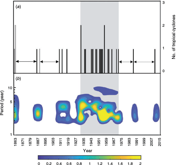
Fig. 3 illustrates the time series of NSW landfalling TC events (number per season). The white columns in Fig. 3a correspond to events that are documented in Callaghan and Power (2014) to have made landfall in NSW but have no track data. The maximum number of landfalling TCs per cyclone season is one, except for 1863/1864, 1934/1935 and 1959/1960 experiencing two events in the season. Temporal distribution of TC events is not consistent throughout the series, with clear active epochs and periods where a hiatus (absent TC activity) is present. The 1950s and 1970s are associated with a higher frequency of landfalling TCs, with the majority of events occurring within this period. Non-active periods in the TC time series include 1865–1885, 1895–1900, 1978–1990 and 1992–2013. This suggests decadal to multi-decadal periodicity in the frequency of landfalling TCs, an insight only made possible by analysing long-term datasets. Importantly, these data suggest that the recent hiatus period is not unusual and similar ‘quiet’ periods have occurred in the past. Fig. 3b highlights the significant active periods of TCs during 1863–2018, with shaded areas corresponding to statistically significant periods of high TC activity (the mid-1930s to mid-1970s).
|
A Wilcoxon rank sum test (for step jump in the median) was applied to the TC time series to further analyse the observed trends. The test statistic, the significant threshold values and the level of significance of each test are shown in Table 2. The result from the rank sum test confirmed two statistically significant step jumps centred on 1940/1941 towards increased TC activity and again in 1964/1965 towards decreased TC activity. This is consistent with the observations of Fig. 3.
|
|
4.3 Causal mechanisms of NSW landfalling TCs
The characteristic geophysical conditions during landfall were explored using composite plots of SST (ERSST v5), RH (20CRv2c;700 hPa) and VWS (20CRv2c; Fig. 4). Monthly data for these three parameters were averaged for all months in which a TC occurred according to the NSW landfalling database. Composite plots of anomalous conditions were also produced by calculating the deviation from the mean climatology, which was based on the full dataset length (1890–2012) to avoid bias in the recent period. Areas of statistical significance that meet a P-value <0.1 are highlighted in colour. Overall, SSTs across equatorial and tropical regions (20°N–20°S) meet the requirements for TC genesis of 26.5°C, while equatorial (10°N–20°S) and mainly the central Pacific (80–240°E) region display favourable RH of at least 40%. Areas of low VWS (<20 m/s) are located along the equatorial and higher tropical regions where TC genesis is observed (Fig. 2). The SST and RH anomaly plots show conditions indicative of a La Niña-like pattern during seasons that experience landfalling TC in NSW, with the familiar cold water upwelling along with the eastern Pacific and horseshoe-shaped extension in the central Pacific. This Pacific driver relationship is further explored in the following section.

|
4.4 Climate index drivers
Fig. 5a is an SOI plot (1866–2018) and the NSW TC time series. Periods shaded blue (red) represent increased La Niña (El Niño) activity. Consistent with the anomaly plot shown in Fig. 4, high-frequency TC activity aligns with periods of La Niña dominant phases. Interestingly, the most recent hiatus period aligns with a significant negative SOI period (reflective of increasing El Niño conditions) highlighted by the running average.

|
Similarly, Fig. 5b shows the relationship between the phases of the IPO and landfalling TC for NSW (note that negative (positive) IPO periods are shaded in blue (red)). In particular, high (low) TC activity coincides with IPO negative (positive) phases, and a decrease in events occurs during the positive phase. This relationship is consistent for the majority of IPO epochs, with the exception of the 2000–2013 period, which was IPO negative yet only resulted in one TC. Further research is needed to ascertain if NSW was just ‘lucky’ during this period, or another factor was dominating TC risk at the time (e.g. MJO).
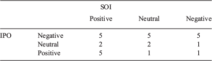
Tables 3 and 4 specify the rate of occurrence of TCs during the combined phases of IPO and ENSO. Each TC within the database (1866–2016) was tallied for the particular phase combination at the time of genesis in Table 3. The analysis confirms that more TC events have historically occurred during IPO negative and SOI positive (La Niña) combinations. Less common events occurred during neutral phases, IPO positive and SOI negative (El Niño) combinations.
|

|
The statistical significance of the probability of TC occurrence during the different phase combinations of SOI and IPO was tested using a test of proportions (Hogg and Tanis 1988; Verdon et al. 2004). For this test the sampling distribution was assumed to be normal with the mean equal to p, the variance equal to p(1 – p)/n, with p being the proportion of TC events that occur during a particular combined SOI/IPO phase and n being the total number of TC events in the TC database. For this process, y1 and y2 alternated based on the combination being tested and are shown in Table 4.
The test statistic in Eqn 2 was used to test the hypothesis of p1 = p2, and P ≤ 0.05 was considered significant.
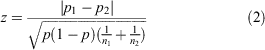
This equation assumed that p1 = y1/n1, p2 = y2/n2, p = (y1 + y2)/(n1 + n2) and z ~ N (0,1).
Combinations that were significant include IPO negative and IPO positive during the SOI negative (El Niño) phase and the SOI neutral phase (P = 0.043). The TC occurrence during the IPO positive phase was also significant compared against El Niño versus La Niña with P = 0.043.
5 Discussion
This study significantly expands our knowledge of landfalling TCs for NSW. A total of 30 landfalling TCs in NSW were identified to have occurred between 1863 and 2018 based on a range of databases and information sources. The fluctuation in landfalling TC events within NSW has occurred in the past (and is likely to occur in the future), with clustering of TC events in the 1950s to 1970s and a recent 35-year period of reduced activity. This finding is consistent with other studies that also found a decrease in TC frequency over time within Australia due to El Niño dominance after 1980 and the weakening of the Walker Circulation (Callaghan and Power 2011; Christensen et al. 2013; Gleixner et al. 2014; Haig et al. 2014). However, the current study shows that this hiatus period is not unusual in the long-term context (1865–1885, 1895–1900, 1978–1990 and 1990–2013) and highlights the issue with assessing trends in TCs over short periods (e.g. post-1979), a problem also raised by Magee and Verdon-Kidd (2019) for the south-west Pacific.
This study suggests that key historical trends for NSW landfalling TCs are influenced by both ENSO and IPO fluctuations (consistent with Callaghan 2020). The combined period of a La Niña and IPO negative phase produced an anomalous period of higher TC activity in the 1950s–1970s. However, compared to other high periods of TC activity, only one climate index was active (La Niña or IPO negative). Occasionally NSW TCs also have occurred during a transitional period of the two climate modes or during a brief decrease from a dominant phase. Importantly, it cannot be determined whether the frequency of the highly active period in the 1950s–1970s was an anomaly or periodic on a longer timescale outside instrumental data limitations. Although the extent of our study is more expansive than most TC studies (by incorporating historical data), to fully understand the periodicity of ENSO and IPO interaction the use of palaeoarchives would provide a more definitive conclusion on this relationship.
Further statistical testing highlighted a significant relationship with the TC occurrence in NSW during differing SOI and IPO phase combinations (Tables 3 and 4). The results suggest that TC occurrence is dependent on the combined or multimodal pairing, with notably elevated TCs occurring during La Niña events that occur within IPO negative periods. These findings highlight the possibility of a return to an anomalous period of higher TC frequency of the 1950s–1970s if the climate modes shift again towards sustained La Niña/IPO negative.
Notable TC events that occurred during these periods of positive SOI and negative IPO include the 1950 ‘Sydney Cyclone’ (10 fatalities in NSW, record low pressure reading in Sydney of 988 hPa and widespread flooding in Qld, NSW and Sydney; Callaghan and Power 2014) and TC Oswald in 2013 (six fatalities, about AU$121 million in damage in NSW and AU$17 100 000 in disaster relief paid out to NSW citizens; AIDR 2018b). The impacts from these events further emphasise the potential risk if a reoccurrence of the 1950–1970 anomaly took place in the future.
The large-scale Pacific drivers act to modulate the environmental variables required for TC genesis (e.g. SST, RH and VWS). Most NSW landfalling TCs are generated within the region of low VWS around northern Australia and migrate south towards NSW (high VWS) to decay. Although a vast region of the Pacific was shown to meet the SST threshold (26.5°C) and RH of 40% during TC genesis months, the anomaly plots highlighted the recognisable La Niña signature, further supporting the statistical analysis.
It is important to note that this study has a relatively low sample size of TCs and as such, may impact on the observed relationships and the statistical tests. Further, the reliability and accessibility of storm-related data decrease pre-1900. Indeed, the brevity of TC and storm records in Australia presents a challenge to analysing periods beyond the last century (Ashcroft et al. 2014; Jaffrés et al. 2018). This is most pertinent to track data, as shown in Fig. 3a (white shaded bars represent TCs that do not contain track data). Data accuracy in representing storm features is another limitation to be considered. For our study, a relatively small buffer was used (0.5 km) to include storms that made landfall but have tracks that indicate they remained offshore (i.e. TC Nancy). Further, track pathways occasionally extend beyond a clearly defined low once making landfall in NSW, which in turn would impact any analysis. Even though this may be the case, it should still be noted that remnants of TCs still have the ability to impact communities.
Taking into account the points above, there is a clear need to extend existing TC databases prior to 1890 (for NSW and the wider Australian region). This raises the question of whether the inclusion of palaeoclimate data and the development of local archives could be used as a viable source to reconstruct this gap in the instrumental record. Palaeo-proxies such as corals, lake sediments, peat cores and erosional geological structures can extend possible events back to 1600 (van Soelen et al. 2013; Nott 2004, 2011, 2018). Another emerging proxy in Australia is tree-rings used in climate reconstruction (Haines et al. 2018). Isotopic analysis can be used to infer the environmental conditions of an area, specifically pluvials (wet periods) and droughts. Pluvials may be linked to flooding and storm occurrence, in particular, TC events (Nott 2018). Accessibility to local archives can be used to expand further on the instrumental record (Ashcroft et al. 2014). Local physical records are also useful in reconstructing tracks and the impacts of storm events historically (Colston et al. 2018). Palaeo-reconstruction is not restricted to just tempest events. Studies by Vance et al. (2015) and Buckley et al. (2019) demonstrated the potential of extending the instrumental record of large-scale climate indices such as the IPO from proxies to predate 1400. Other studies (Verdon and Franks 2006; Heinrich et al. 2009) have used coral and tree-ring records to investigate the relationship of ENSO, IPO and precipitation in Australia.
Future trends in TC activity for this region are poorly constrained. However, evidence from current cyclonic trends aligns with our concern for the future TC risk of NSW. For example, the extended poleward decay of TC events resulting from the migration of the Hadley Cell circulation (Lavender and Walsh 2011; Sharmila and Walsh 2018) and the further southward movement of the sub-tropic jet has reduced wind shear in the eastern basin, contributing to an extension of the TC lifetime (Kuleshov et al. 2010). This may allow for TCs to travel and decay further than usual and increase the rate of crossing into NSW (similar to the 1950 ‘Sydney Cyclone’, which travelled as far as Sydney). Further, landfalling TC hourly rain production is projected to increase by 27% along eastern Australia by 2100 (Christensen et al. 2013; Parker et al. 2018), increasing the probability of major coastal flooding (Bruyère et al. 2019). Based on these studies, particular areas of concern are centred on the south-east Qld border through to central NSW.
Recommended extensions of this work include the investigation of palaeoclimate proxies in Australia as a method to elongate and substantiate the pre-1900 time series of TC and storm events. Further research is also needed to compare the environmental conditions of landfalling TCs in NSW compared to non-landfalling TCs. Additionally, future work could incorporate the expansion of different types of storms (i.e. east coast lows) within a comparative study, focusing on the investigation of storm occurrence and tracks during this hiatus period, identifying any decreasing trends within the time series.
6 Conclusions
This study shows that periodic hiatuses in TC activity can occur in NSW; however, such periods can also be followed by a period of increased TC activity. Further, we establish that heightened TC activity is more likely to occur during La Niña events occurring within an IPO negative phase. Therefore, a return to a more active TC period (such as the 1950s–1970s) in the future is possible if the Pacific conditions align. However, due to data limitations, the extent to which the highly active period in 1950–1970 may be anomalous or periodic requires a longer time series, which can only be produced from palaeoarchives. Further, the extent to which anthropogenic climate change may impact on these relationships is yet to be fully understood. Regardless, the combination of instrumental records and pre-instrumental archives (e.g. newspapers, diaries and ship logs) advances the understanding of long-term variability of landfalling TC occurrence. Future inclusion of palaeo-proxies will help examine the underlying climate variability and trends within the historical storm tracks of Australia. Importantly this will provide better information for more informed decisions on storm preparation in NSW.
Conflicts of interest
The authors declare that there are no conflicts of interest.
Acknowledgements
J.L. Gray acknowledges the University of Newcastle for providing the opportunity to study during her Honours year, the financial support of Central Queensland University (CQU) and financial support from a postgraduate scholarship from the Commonwealth Scientific and Industrial Research Organisation (CSIRO, supervisor John Clarke). Dr Jasmine Jaffrés from C&R Consulting and Krishneel Sharma from the University of Newcastle both provided programming and technical support with vertical wind shear analysis. The authors would like to acknowledge the Bindal, Wulgurukaba and the Pambalong clan of the Awabakal people – the traditional owners of the land on which this research was conducted. We also pay our respects to the Indigenous elders of the past, present and emerging.
References
Ashcroft, L., Gergis, J., and Karoly, D. J. (2014). A historical climate dataset for southeastern Australia, 1788–1859. Geosci. Data J. 1, 158–178.| A historical climate dataset for southeastern Australia, 1788–1859.Crossref | GoogleScholarGoogle Scholar |
Australian Institute for Disaster Resilience (AIDR) (2018a). Queensland and NSW, February 1990: Cyclone- Cyclone Nancy. Available at https://knowledge.aidr.org.au/resources/cyclone-cyclone-nancy-queensland/ [Accessed 16 September 2019].
Australian Institute for Disaster Resilience (AIDR) (2018b). Queensland and New South Wales 2013: Cyclone Oswald. Available at https://knowledge.aidr.org.au/resources/cyclone-oswald-queensland-new-south-wales-2013/ [Accessed 16 September 2019].
Bruyère, C. L., Done, J. M., Jaye, A. B., Holland, G. J., Buckley, B., Henderson, D. J., Leplastrier, M., and Chan, P. (2019). Physically-based landfalling tropical cyclone scenarios in support of risk assessment. Weather Clim. Extrem. 26, 100229.
| Physically-based landfalling tropical cyclone scenarios in support of risk assessment.Crossref | GoogleScholarGoogle Scholar |
Buckley, B. M., Ummenhofer, C. C., D’Arrigo, R. D., Hansen, K. G., Truong, L. H., Le, C. N., and Stahle, D. K. (2019). Interdecadal Pacific Oscillation reconstructed from trans-Pacific tree rings: 1350–2004 CE. Clim. Dyn. 53, 3181–3196.
| Interdecadal Pacific Oscillation reconstructed from trans-Pacific tree rings: 1350–2004 CE.Crossref | GoogleScholarGoogle Scholar |
Bureau of Meteorology (2018). About Tropical Cyclones. Available at http://www.bom.gov.au/cyclone/about/ [Accessed 16 September 2019].
Bureau of Meteorology (2019). Previous Tropical Cyclones. Available at http://www.bom.gov.au/cyclone/history/index.shtml [Accessed 10 December 2019].
Callaghan, J. (2020). Extraordinary sequence of severe weather events in the late nineteenth century. J. South. Hemisph. Earths Syst. Sci. , .
| Extraordinary sequence of severe weather events in the late nineteenth century.Crossref | GoogleScholarGoogle Scholar |
Callaghan, J. and Helman, P. (2008). Severe storms on the east coast of Australia 1770–2008. Bureau of Meteorology, Griffith Centre for Coastal Management. Available at https://www.researchgate.net/publication/29469755_Severe_Storms_on_the_East_Coast_of_Australia_1770-2008.
Callaghan, J., and Power, S. B. (2011). Variability and decline in the number of severe tropical cyclones making land-fall over eastern Australia since the late nineteenth century. Clim. Dyn. 37, 647–662.
| Variability and decline in the number of severe tropical cyclones making land-fall over eastern Australia since the late nineteenth century.Crossref | GoogleScholarGoogle Scholar |
Callaghan, J., and Power, S. B. (2014). Major coastal flooding in southeastern Australia 1860-2012, associated deaths and weather systems. Aust. Meteorol. Oceanogr. J. 64, 183–213.
| Major coastal flooding in southeastern Australia 1860-2012, associated deaths and weather systems.Crossref | GoogleScholarGoogle Scholar |
Chiew, F. and Siriwardena, L. (2005). Trend/change detection software: user manual, eWater toolkit: Documentation. pp. 1–29. Available at https://toolkit.ewater.org.au/Tools/TREND/documentation.
Christensen, J., Krishna, K., Aldrain, E., An, S., Cavalcanti, I. F., de Castro, M., Dong, W., Goswami, P., Hall, A., Kanyanga, J., Kitoh, A., Kossin, J., Lau, N., Renwick, J., Stephenson, D., Xie, S. and Zhou, T. (2013). Climate Phenomena and their Relevance for Future Regional Climate Change. In ‘Climate Change 2013: The Physical Science Basis. Contribution of Working Group I to the Fifth Assessment Report of the Intergovernmental Panel on Climate Change’. (Eds T. F. Stocker, D. Qin, G.-K. Plattner, M. Tignor, S. K. Allen, J. Boschung, A. Nauels, Y. Xia, V. Bex and P. M. Midgley) pp. 1217–1308. (Cambridge University Press: Cambridge United Kingdom and New York, NY, USA).
Coleman, F. (1972). Frequencies, tracks and intensities of tropical cyclones in the Australian region 1909 to 1969. Bureau of Meteorology, Australia, Melbourne. Available at https://trove.nla.gov.au/work/9320228?q=Coleman+F+cyclone&c=book&sort=holdings+desc&_=1576034882144&versionId=10810867.
Colston, J. M., Ahmed, T., Mahopo, C., Kang, G., Kosek, M., de Sousa Junior, F., Shrestha, P. S., Svensen, E., Turab, A., and Zaitchik, B. (2018). Evaluating meteorological data from weather stations, and from satellites and global models for a multi-site epidemiological study. Environ. Res. 165, 91–109.
| Evaluating meteorological data from weather stations, and from satellites and global models for a multi-site epidemiological study.Crossref | GoogleScholarGoogle Scholar | 29684739PubMed |
Diamond, H. J., Lorrey, A. M., Knapp, K. R., and Levinson, D. H. (2012). Development of an enhanced tropical cyclone tracks database for the Southwest Pacific from 1840 to 2010. Int. J. Climatol. 32, 2240–2250.
| Development of an enhanced tropical cyclone tracks database for the Southwest Pacific from 1840 to 2010.Crossref | GoogleScholarGoogle Scholar |
Diamond, H. J., and Renwick, J. A. (2015). The climatological relationship between tropical cyclones in the southwest pacific and the southern annular mode. Int. J. Climatol. 35, 613–623.
| The climatological relationship between tropical cyclones in the southwest pacific and the southern annular mode.Crossref | GoogleScholarGoogle Scholar |
Dowdy, A. J. (2014). Long-term changes in Australian tropical cyclone numbers. Atmos. Sci. Lett. 15(4), 292–298
Folland, C. (2017). Interdecadal Pacific Oscillation Time Series. Available at http://cola.gmu.edu/c20c/ [Accessed 1 October 2019].
Forino, G., von Meding, J., Brewer, G., and van Niekerk, D. (2017). Climate Change Adaptation and Disaster Risk reduction integration: Strategies, Policies, and Plans in three Australian Local Governments. Int. J. Disaster Risk Reduct. 24, 100–108.
| Climate Change Adaptation and Disaster Risk reduction integration: Strategies, Policies, and Plans in three Australian Local Governments.Crossref | GoogleScholarGoogle Scholar |
Gleixner, S., Keenlyside, N., Hodges, K. I., Tseng, W. L., and Bengtsson, L. (2014). An inter-hemispheric comparison of the tropical storm response to global warming. Clim. Dyn. 42, 2147–2157.
| An inter-hemispheric comparison of the tropical storm response to global warming.Crossref | GoogleScholarGoogle Scholar |
Grant, A. P., and Walsh, K. J. E. (2001). Interdecadal variability in north-east Australian tropical cyclone formation. Atmos. Sci. Lett. 2, 9–17.
| Interdecadal variability in north-east Australian tropical cyclone formation.Crossref | GoogleScholarGoogle Scholar |
Haig, J., Nott, J., and Reichart, G. J. (2014). Australian tropical cyclone activity lower than at any time over the past 550-1,500 years. Nature 505, 667–670.
| Australian tropical cyclone activity lower than at any time over the past 550-1,500 years.Crossref | GoogleScholarGoogle Scholar | 24476890PubMed |
Haines, H. A., Olley, J. M., English, N. B., and Hua, Q. (2018). Anomalous ring identification in two Australian subtropical Araucariaceae species permits annual ring dating and growth-climate relationship development. Dendrochronologia 49, 16–28.
| Anomalous ring identification in two Australian subtropical Araucariaceae species permits annual ring dating and growth-climate relationship development.Crossref | GoogleScholarGoogle Scholar |
Hall, J. D., Matthews, A. J., and Karoly, D. J. (2002). The Modulation of Tropical Cyclone Activity in the Australian Region by the Madden–Julian Oscillation. Mon. Wea. Rev. 129, 2970–2982.
| The Modulation of Tropical Cyclone Activity in the Australian Region by the Madden–Julian Oscillation.Crossref | GoogleScholarGoogle Scholar |
Heinrich, I., Weidner, K., Helle, G., Vos, H., Lindesay, J., and Banks, J. C. G. (2009). Interdecadal modulation of the relationship between ENSO, IPO and precipitation: Insights from tree rings in Australia. Clim. Dyn. 33, 63–73.
| Interdecadal modulation of the relationship between ENSO, IPO and precipitation: Insights from tree rings in Australia.Crossref | GoogleScholarGoogle Scholar |
Henley, B. J., Gergis, J., Karoly, D. J., Power, S., Kennedy, J., and Folland, C. K. (2015). A Tripole Index for the Interdecadal Pacific Oscillation. Clim. Dyn. 45, 3077–3090.
| A Tripole Index for the Interdecadal Pacific Oscillation.Crossref | GoogleScholarGoogle Scholar |
Hogg, R. and Tanis, E. (1988). Probability and statistical inference 3rd edn. (Macmillian Publishing: New York.)
Hoque, M. A. A., Phinn, S., Roelfsema, C., and Childs, I. (2017). Tropical cyclone disaster management using remote sensing and spatial analysis: A review. Int. J. Disaster Risk Reduct. 22, 345–354.
| Tropical cyclone disaster management using remote sensing and spatial analysis: A review.Crossref | GoogleScholarGoogle Scholar |
Jaffrés, J. B. D., Cuff, C., Rasmussen, C., and Hesson, A. S. (2018). Teleconnection of atmospheric and oceanic climate anomalies with Australian weather patterns: a review of data availability. Earth-Science Rev. 176, 117–146.
| Teleconnection of atmospheric and oceanic climate anomalies with Australian weather patterns: a review of data availability.Crossref | GoogleScholarGoogle Scholar |
Jänicke, H., Böttinger, M., Mikolajewicz, U., and Scheuermann, G. (2009). Visual exploration of climate variability using wavelet analysis. IEEE Trans. Vis. Comput. Graph. 15, 1375–1382.
| Visual exploration of climate variability using wavelet analysis.Crossref | GoogleScholarGoogle Scholar | 19834211PubMed |
Jin, F. F., Boucharel, J., and Lin, I. I. (2014). Eastern Pacific tropical cyclones intensified by El Ninõ delivery of subsurface ocean heat. Nature 516, 82–85.
| Eastern Pacific tropical cyclones intensified by El Ninõ delivery of subsurface ocean heat.Crossref | GoogleScholarGoogle Scholar | 25471884PubMed |
Kalnay, E., Kanamitsu, M., Kistler, R., Collins, W., Deaven, D., Gandin, L., Iredell, M., Jenne, R., and Joseph, D. (1996). The NCEP NCAR 40-Year Reanalysis Project. Bull. Amer. Meteor. Soc. 77, 437–472.
| The NCEP NCAR 40-Year Reanalysis Project.Crossref | GoogleScholarGoogle Scholar |
Können, G., Jones, P., Kaltofen, M. H., and Allan, R. (1998). Pre-1866 Extensions of the Southern Oscillation Index Using Early Indonesian and Tahitian Meteorological Readings. J. Climate 11, 2325–2339.
| Pre-1866 Extensions of the Southern Oscillation Index Using Early Indonesian and Tahitian Meteorological Readings.Crossref | GoogleScholarGoogle Scholar |
Kuleshov, Y., Fawcett, R., Qi, L., Trewin, B., Jones, D., McBride, J., and Ramsay, H. (2010). Trends in tropical cyclones in the South Indian Ocean and the South Pacific Ocean. J. Geophys. Res. Atmos. 115, 1–9.
| Trends in tropical cyclones in the South Indian Ocean and the South Pacific Ocean.Crossref | GoogleScholarGoogle Scholar |
Lavender, S., and Abbs, D. (2013). Trends in Australian rainfall: Contribution of tropical cyclones and closed lows. Clim. Dyn. 40, 317–326.
| Trends in Australian rainfall: Contribution of tropical cyclones and closed lows.Crossref | GoogleScholarGoogle Scholar |
Lavender, S., and Walsh, K. (2011). Dynamically downscaled simulations of Australian region tropical cyclones in current and future climates. Geophys. Res. Lett. 38, 1–6.
| Dynamically downscaled simulations of Australian region tropical cyclones in current and future climates.Crossref | GoogleScholarGoogle Scholar |
Liu, K. S., and Chan, J. C. L. (2012). Interannual variation of Southern Hemisphere tropical cyclone activity and seasonal forecast of tropical cyclone number in the Australian region. Int. J. Climatol. 32, 190–202.
| Interannual variation of Southern Hemisphere tropical cyclone activity and seasonal forecast of tropical cyclone number in the Australian region.Crossref | GoogleScholarGoogle Scholar |
Lourensz R. S. (1981). TCs in the Australian region from July 1909 to June 1980. Bureau of Meteorology (ed), Australian Government Publishing Service, Canberra.
Magee, A. D., and Verdon-Kidd, D. C. (2019). Historical variability of Southwest Pacific tropical cyclone counts since 1855. Geophys. Res. Lett. 46, 6936–6945.
| Historical variability of Southwest Pacific tropical cyclone counts since 1855.Crossref | GoogleScholarGoogle Scholar |
Magee, A. D., Verdon-Kidd, D. C., Diamond, H. J., and Kiem, A. S. (2017). Influence of ENSO, ENSO Modoki, and the IPO on tropical cyclogenesis: a spatial analysis of the Southwest Pacific region. Int. J. Climatol. 37, 1118–1137.
| Influence of ENSO, ENSO Modoki, and the IPO on tropical cyclogenesis: a spatial analysis of the Southwest Pacific region.Crossref | GoogleScholarGoogle Scholar |
Magee, A. D., Verdon-Kidd, D. C., Kiem, A. S., and Royle, S. A. (2016). Tropical cyclone perceptions, impacts and adaptation in the Southwest Pacific: An urban perspective from Fiji, Vanuatu and Tonga. Nat. Hazards Earth Syst. Sci. 16, 1091–1105.
| Tropical cyclone perceptions, impacts and adaptation in the Southwest Pacific: An urban perspective from Fiji, Vanuatu and Tonga.Crossref | GoogleScholarGoogle Scholar |
Marks, K. M., and Smith, W. H. F. (2006). An evaluation of publicly available global bathymetry grids. Mar. Geophys. Res. 27(1), 19–34
McBride, J. L., and Holland, G. J. (1987). Tropical-cyclone forecasting: a worldwide summary of techniques and verification statistics. Bull. Am. Meteorol. Soc. 68, 1230–1238.
| Tropical-cyclone forecasting: a worldwide summary of techniques and verification statistics.Crossref | GoogleScholarGoogle Scholar |
Met Office Hadley Centre for Climate Change (2016). Interdecadal Pacific Oscillation time series. Available at http://cola.gmu.edu/c20c/ [Accessed 19 September 2019].
Nott, J. (2004). Palaeotempestology: The study of prehistoric tropical cyclones - A review and implications for hazard assessment. Environ. Int. 30, 433–447.
| Palaeotempestology: The study of prehistoric tropical cyclones - A review and implications for hazard assessment.Crossref | GoogleScholarGoogle Scholar | 14987874PubMed |
Nott, J. (2011). A 6000 year tropical cyclone record from Western Australia. Quat. Sci. Rev. 30, 713–722.
| A 6000 year tropical cyclone record from Western Australia.Crossref | GoogleScholarGoogle Scholar |
Nott, J. (2018). The influence of tropical cyclones on long-term riverine flooding; examples from tropical Australia. Quat. Sci. Rev. 182, 155–162.
| The influence of tropical cyclones on long-term riverine flooding; examples from tropical Australia.Crossref | GoogleScholarGoogle Scholar |
Parker, C. L., Bruyère, C. L., Mooney, P. A., and Lynch, A. H. (2018). The response of land-falling tropical cyclone characteristics to projected climate change in northeast Australia. Clim. Dyn. 51, 3467–3485.
| The response of land-falling tropical cyclone characteristics to projected climate change in northeast Australia.Crossref | GoogleScholarGoogle Scholar |
Potter, T. and Coleman, B. (2003). Handbook of weather climate and water: dynamics, climate physical meteorology, weather systems and measurements. (John Wiley and Sons Inc: United States of America.)
Ramsay, H., Richman, M. B., and Leslie, L. M. (2017). The modulating influence of Indian Ocean sea surface temperatures on Australian region seasonal tropical cyclone counts. J. Climate 30, 4843–4856.
| The modulating influence of Indian Ocean sea surface temperatures on Australian region seasonal tropical cyclone counts.Crossref | GoogleScholarGoogle Scholar |
Ramsay, H. A., Leslie, L. M., Lamb, P. J., Richman, M. B., and Leplastrier, M. (2008). Interannual variability of tropical cyclones in the Australian region: Role of large-scale environment. J. Climate 21, 1083–1103.
| Interannual variability of tropical cyclones in the Australian region: Role of large-scale environment.Crossref | GoogleScholarGoogle Scholar |
Ropelewski, C. F., and Jones, P. (1987). SOI- an extension to the Tahiti-Darwin SOI. Mon. Wea. Rev. 115, 2161–2165.
| SOI- an extension to the Tahiti-Darwin SOI.Crossref | GoogleScholarGoogle Scholar |
SES (NSW State Emergency Service) (2018). STORM HAZARD AND RISK IN NEW SOUTH WALES - Supporting Document to the NSW State Storm Plan. p. 7. Available at https://www.ses.nsw.gov.au/media/2703/storm-hazard-and-risk-in-nsw.pdf.
Sewell, T., Stephens, R. E., Dominey-Howes, D., Bruce, E., and Perkins-Kirkpatrick, S. (2016). Disaster declarations associated with bushfires, floods and storms in New South Wales, Australia between 2004 and 2014. Sci. Rep. 6, 36369.
| Disaster declarations associated with bushfires, floods and storms in New South Wales, Australia between 2004 and 2014.Crossref | GoogleScholarGoogle Scholar | 27819298PubMed |
Sharmila, S., and Walsh, K. J. E. (2018). Recent poleward shift of tropical cyclone formation linked to Hadley Cell expansion. Nat. Clim. Chang 8, 730–736.
| Recent poleward shift of tropical cyclone formation linked to Hadley Cell expansion.Crossref | GoogleScholarGoogle Scholar |
van Soelen, E. E., Wagner-Cremer, F., Damsté, J. S. S., and Reichart, G. J. (2013). Reconstructing tropical cyclone frequency using hydrogen isotope ratios of sedimentary n-alkanes in northern Queensland, Australia. Palaeogeogr. Palaeoclimatol. Palaeoecol. 376, 66–72.
| Reconstructing tropical cyclone frequency using hydrogen isotope ratios of sedimentary n-alkanes in northern Queensland, Australia.Crossref | GoogleScholarGoogle Scholar |
Terry, J. (2007). Tropical Cyclones: Climatology and Impacts in the South Pacific. (Springer: New York.) Available at https://link.springer.com/book/10.1007%2F978-0-387-71543-8
Trouet, V., and Van Oldenborgh, G. J. (2013). KNMI Climate Explorer: A Web-Based Research Tool for High-Resolution Paleoclimatology. Tree-Ring Res. 69(1), 3–13.
Vance, T. R., Roberts, J. L., Plummer, C. T., Kiem, A. S., and Van Ommen, T. D. (2015). Interdecadal Pacific variability and eastern Australian megadroughts over the last millennium. Geophys. Res. Lett. 42, 129–137.
| Interdecadal Pacific variability and eastern Australian megadroughts over the last millennium.Crossref | GoogleScholarGoogle Scholar |
Verdon, D. C., and Franks, S. W. (2006). Long-term behaviour of ENSO: Interactions with the PDO over the past 400 years inferred from paleoclimate records. Geophys. Res. Lett. 33, 1–5.
| Long-term behaviour of ENSO: Interactions with the PDO over the past 400 years inferred from paleoclimate records.Crossref | GoogleScholarGoogle Scholar |
Verdon, D. C., Kiem, A. S., and Franks, S. W. (2004). Multi-decadal variability of forest fire risk - Eastern Australia. Int. J. Wildl. Fire 13, 165–171.
| Multi-decadal variability of forest fire risk - Eastern Australia.Crossref | GoogleScholarGoogle Scholar |
Woodruff, J. D., Irish, J. L., and Camargo, S. J. (2013). Coastal flooding by tropical cyclones and sea-level rise. Nature 504, 44–52.
| Coastal flooding by tropical cyclones and sea-level rise.Crossref | GoogleScholarGoogle Scholar | 24305147PubMed |
You, Z.-J., and Lord, D. (2008). Influence of the El Niño–Southern Oscillation on NSW Coastal Storm Severity. J. Coast. Res. 2, 203–207.
| Influence of the El Niño–Southern Oscillation on NSW Coastal Storm Severity.Crossref | GoogleScholarGoogle Scholar |
Zhong, S., Wang, C., Yu, Z., Yang, Y., and Huang, Q. (2018). Spatiotemporal exploration and hazard mapping of tropical cyclones along the coastline of China. Adv. Meteorol. 2018, 1–15.
| Spatiotemporal exploration and hazard mapping of tropical cyclones along the coastline of China.Crossref | GoogleScholarGoogle Scholar |