
Intense east coast lows and associated rainfall in eastern Australia
Acacia Pepler A B and Andrew Dowdy A
A Bureau of Meteorology, Melbourne, Vic., Australia.
B Corresponding author. Email: acacia.pepler@bom.gov.au
Journal of Southern Hemisphere Earth Systems Science 71(1) 110-122 https://doi.org/10.1071/ES20013
Submitted: 2 November 2020 Accepted: 19 February 2021 Published: 19 March 2021
Journal Compilation © BoM 2021 Open Access CC BY-NC-ND
Abstract
East coast lows (ECLs) are low pressure systems that occur near the east coast of Australia. But not all lows cause the same level of impact, and a small proportion of ECLs are responsible for more than half of all days with widespread rainfall above 50 mm in this region. In this study, we combine analyses of cyclones at both the surface and 500 hPa levels to assess the locations of cyclones responsible for widespread heavy rainfall on the east coast. We found that the majority of days with widespread totals above 100 mm on the east coast occur when a low at 500 hPa over inland southeast Australia coincides with a surface low located more directly over the east coast. Such events occur on about 15 days per year but are responsible for more than 50% of days with widespread heavy rainfall on the eastern seaboard of Australia. We also found that extreme rainfall was most likely when both the surface and upper cyclones were very strong, when measured using the maximum Laplacian of pressure/height. The seasonal frequency of cyclones at the surface and 500 hPa were found to be only weakly correlated with each other and often had opposing relationships (albeit weak in magnitude) with both global climate drivers and indices of local circulation variability. Trends in cyclone frequency were weak over the period 1979–2019, but there was a small decline in the frequency of deep cyclone days, which was statistically significant in some parts of the southeast. Understanding which ECLs are associated with heavy rainfall will help us to better identify how future climate change will influence ECL impacts.
Keywords: Australia, cyclone, east coast lows, eastern seaboard, ECLs, ENSO, extreme rainfall, trends, variability.
1 Introduction
Cyclones are one of the most important weather systems for both total and extreme rainfall across large parts of the globe (Hawcroft et al. 2012; Pfahl and Wernli 2012; Dowdy and Catto 2017). On the eastern seaboard (ESB) of Australia, the cyclones that are locally known as east coast lows (ECLs) are responsible for more than 25% of annual rainfall (Pepler et al. 2014) and more than 60% of days with widespread coastal flooding or significant dam inflows (Pepler and Rakich 2010; Callaghan and Power 2014). They are also responsible for the majority of days with large waves or storm surge in coastal regions (McInnes and Hubbert 2001; Shand et al. 2011; Dowdy et al. 2014) as well as other severe impacts, including persistent strong winds and, in some cases, embedded thunderstorms and convection-related severe winds (Dowdy et al. 2019).
While ECLs have been defined in a number of ways, a recent review paper (Dowdy et al. 2019) provided a generalised definition of ECLs and intense ECLs that synthesised these studies, while acknowledging that specific sub-types and more constrained definitions may be practical for some purposes. Broadly speaking, ECLs are cyclones near southeastern Australia that can be caused by both midlatitude and tropical influences over a range of levels in the atmosphere; intense ECLs have at least one major hazard associated with their occurrence, including extreme winds, waves, rain or flooding (Dowdy et al. 2019).
A large number of datasets of ECLs have been developed, both from manual analysis of synoptic charts or newspaper records (Speer et al. 2009; Callaghan and Power 2014) as well as from a range of automated cyclone detection schemes applied to both mean sea level pressure (MSLP) (Browning and Goodwin 2013; Pepler et al. 2015) and 500 hPa geostrophic vorticity (Dowdy et al. 2013a). These study outcomes and associated output data are sensitive to choices of method, reanalysis, spatial resolution, and minimum thresholds applied, leading to uncertainty in many parameters of ECLs, including their frequency, seasonal variability, relationships with major drivers and long-term trends (Di Luca et al. 2015; Pepler et al. 2015; Dowdy et al. 2019).
In addition to the uncertainty arising from identification methods, the characteristics of ECLs can vary significantly between systems, with the ESB subjected to cyclones ranging from ex-tropical cyclones to deep extratropical cyclones from the midlatitude storm tracks. Thus, ECLs can include both warm-cored and cold-cored systems as well as cyclones that have hybrid characteristics (Cavicchia et al. 2019; Quinting et al. 2019). This has led to the emergence of a number of ways to subcategorise ECLs, including definitions based on sea level pressure patterns (Hopkins and Holland 1997; Speer et al. 2009); vertical profiles using the Hart (2003) phase space to distinguish between cold-core, warm-core and hybrid systems (Cavicchia et al. 2019; Quinting et al. 2019); or using backtracking to identify the genesis and movement of the precursor surface low/trough (Browning and Goodwin 2013). Each of these classification approaches found that the average locations and impacts of ECLs vary depend on the subcategory used.
To add to this variety of classification approaches, case studies of individual ECLs consistently identify that a strong cut off low to the northwest of the east coast is an important precursor to many of the most severe ECLs (Dowdy et al. 2011, 2013a). Following this, analysis of the vertical structure of cyclones near the east coast identified that those ECLs that have deep structures have longer duration, heavier rainfall and stronger winds than shallow systems that are identified at only the surface levels or upper levels (Pepler and Dowdy 2020). This suggests a potential new approach for subclassifying ECLs based on their depth.
While a large number of cyclones occur near the east coast each year, only a smaller proportion of these have been associated with significant coastal impacts. For instance, Speer et al. (2009) reported 22 ECLs per year but only eight were associated with widespread rainfall above 25 mm, while datasets of more severe ECLs typically include only one or two per year (Hopkins and Holland 1997; Callaghan and Power 2014).
Objectively identifying those cyclones that are likely to produce the most significant impacts would be a benefit for studies assessing the likely future changes in those systems which matter most for the highly populated east coast. To that end, in this paper we build on the results of Pepler and Dowdy (2020) to assess the interaction between the depth of an ECL and its intensity at both the surface and upper levels and identify the combination of ECL characteristics most likely to indicate an intense ECL with widespread coastal rainfall.
2 Data and methods
ECLs were tracked for the period 1979–2019 using the ERA5 reanalysis (Hersbach et al. 2020), which is available at 0.25° spatial resolution. This is the successor to the ERA-Interim reanalysis, which was one of the most widely used for assessing cyclones around the globe (Neu et al. 2013; Tilinina et al. 2013; Di Luca et al. 2015; Pepler et al. 2018). ECL frequencies in ERA5 are similar to other widely used reanalyses (Pepler 2020).
For this paper, we used a simplified version of the method of Pepler and Dowdy (2020), with cyclones tracked using just MSLP and 500 hPa geopotential height, allowing it to be more readily applied to a range of datasets, including climate model simulations. In the case of surface cyclones, this analysis was performed at 6-h resolution; but for upper cyclones, the ERA5 geopotential data was converted to a daily mean field by averaging the four observations at 0000, 0600, 1200 and 1800 UTC. Daily temporal resolution for upper cyclones is consistent with previous studies based on global models (Dowdy et al. 2013a, 2014), also noting that upper cyclones tend to be longer-lived than surface cyclones (Pepler and Dowdy 2020), although this is complicated by a tendency for cyclones to include split tracks and multiple centres at the surface. We also tested results using upper cyclones identified using the 6-h data, but these had less skill at identifying heavy rain days than the daily observations, possibly because shallow upper cyclones that have little rainfall tend to be fast-moving so are less likely to be observed in daily mean geopotential height than the slower-moving and more impactful events (Pepler and Dowdy 2020).
Cyclones were identified and tracked using the University of Melbourne cyclone tracking scheme (Murray and Simmonds 1991; Simmonds et al. 1999), which has been widely used for tracking cyclones and compares well to other methods and manual databases (Lim and Simmonds 2007; Allen et al. 2010; Neu et al. 2013; Pepler et al. 2015). The gridded fields were first transformed to a polar projection, with a common resolution of ~1.5° at 30°S for all datasets. For MSLP cyclones, filtering was applied over elevated topography so that lows above 1000 m were removed; this represented less than 1% of the land area of southeast Australia (20–45°S, 130–160°E). The algorithm first searches for a maximum in the Laplacian of the gridded field before identifying the location of a local minimum. Both closed and open cyclones were considered, as some small but impactful surface cyclones may not be resolved properly in coarse resolution fields (Hopkins and Holland 1997; Dowdy et al. 2019), and previous studies of upper cyclones did not distinguish between open systems (troughs) and closed cyclones (Dowdy et al. 2014).
The average Laplacian of MSLP (or geopotential height) within a 2° radius of the cyclone centre is related to the cyclone’s vorticity, and is used as the primary measure of cyclone intensity. Cyclones are initially tracked using an arbitrary low intensity threshold, with surface cyclones required to have an average intensity of at least 0.5 hPa (deg. lat.)−2 averaged over a 2° radius around the cyclone centre and upper cyclones required to exceed 1 m (deg. lat.)−2. Subsequent thresholds are identified in Section 3 to give an equal number of cyclone days per year at each level, informed by the cyclone frequencies in a manual database for 1970–2006 (Speer et al. 2009). No minimum duration criterion was applied, to allow for cases where a cyclone is divided into multiple tracks or centres (Pepler and Coutts-Smith 2013) or where an upper level cyclone is only associated with surface development for a short amount of time (Dowdy et al. 2011).
For the purposes of this analysis, we focused on rainfall along the highly populated coast east of the Great Dividing Range, known as the eastern seaboard (ESB). This was defined similarly to previous studies (Timbal 2010; Kiem et al. 2016; Pepler et al. 2016b) and is indicated with a polygon throughout the paper (e.g. Fig. 1). We defined heavy rainfall as days when high daily rainfall totals cover a large area, which can result in widespread flooding and other impacts, while noting that extreme sub-daily rainfall totals may be more important for local impacts, such as flash flooding, and dominated by different weather systems.
|
To identify the relationship between cyclones and heavy rainfall, we used the Australian Water Availability Project (AWAP) Australian gridded rainfall dataset at a 0.05° resolution (Jones et al. 2009). This is recorded over the 24 h to 9 am local time, which in eastern Australia is 2300 UTC during the cool half of the year and 2200 UTC during daylight savings time (October–April). Following the approach of Pepler et al. (2014), we identified periods of widespread rainfall based on the proportion of grid points in the ESB region that exceed a given threshold. Moderate rainfall days were defined where the number of cells exceeding 25 mm was above the 95th percentile for all days (12.7% of the domain), heavy rain days where the number of cells exceeding 50 mm was above the 99th percentile for all days (12.0% of the domain), and extreme rain days where the number of cells exceeding 100 mm was above the 99.5th percentile for all days (4% of the domain). After identifying heavy rain days, we used the locations of observed cyclones on these days to select the regions used for identifying ECLs at each level. By comparing the surface region with the Speer et al. (2009) dataset, we could identify appropriate intensity (Laplacian) thresholds to give the same number of ECL days per year. Finally, days were then classified as having a ‘deep’, ‘surface-only’ or ‘upper-only’ cyclone based on whether or not a cyclone was identified in the appropriate spatial domain at any point on that day.
AWAP is one of the most widely used gridded datasets for Australian rainfall and is strongly correlated with station rainfall in areas with high station density, such as southeast Australia. While it tends to underestimate the value of the most intense rainfall extremes at individual stations (King et al. 2013), this is more important for annual maxima and localised extreme events, and AWAP is well able to represent the spatial extent of more moderate extremes, such as assessed in this study. However, to supplement this analysis we also assessed the role of the identified ECL days in heavy (99th percentile) rainfall at four representative rainfall stations along the east coast: Eden (37.08°S, 149.91°E), Sydney Observatory Hill (33.86°S, 151.20°E), South West Rocks (30.92°S, 153.09°E) and Brisbane Airport (27.39°S, 153.13°E).
To assess the correlations between ECLs and their associated rainfall and major indices of climate variability we first linearly detrended both the ECL and climate driver timeseries before calculating Pearson’s r. The El Niño-Southern Oscillation (ENSO) is represented by the Southern Oscillation Index, (SOI; available from http://www.bom.gov.au/climate/current/soi2.shtml), while the Indian Ocean Dipole (IOD) is represented by the Dipole Mode Index (DMI; http://stateoftheocean.osmc.noaa.gov/sur/ind/dmi.php) between 1982 and 2019, which was converted from weekly to monthly data as the weighted average of all weeks (partially) within that month. The Southern Annular Mode (SAM) is represented by the Antarctic Oscillation Index (http://www.cpc.ncep.noaa.gov/products/precip/CWlink/daily_ao_index/aao/aao.shtml). The subtropical ridge position (STRP) and subtropical ridge intensity (STRI) were calculated for the longitudes 145–150°E from Bureau of Meteorology observed sea level pressure data using the method of Drosdowsky (2005) and was available for the period from 1890. The Gayndah–Deniliquin Index (GDI), an index of zonal wind-flow over southeast Australia, was calculated using Bureau of Meteorology observed station sea level pressure data using the method of Rakich et al. (2008). In calculating composites for ENSO and IOD states, we used the years listed by the Bureau of Meteorology at http://www.bom.gov.au/climate/enso/enlist/, http://www.bom.gov.au/climate/enso/lnlist/index.shtml and http://www.bom.gov.au/climate/iod/.
3 Association of cyclones with east coast heavy rain
Due to the focus of this study on the more intense ECLs that can cause extreme rainfall, using a multilevel analysis approach that considers deep and shallow systems, we started by examining the surface and upper level low pressure systems on days with rainfall in the ESB. This was intended to build on previous studies by refining the regions used for identifying the lows at these levels. Pepler and Dowdy (2020) used a single region to assess cyclones identified at any vertical level for assessing the rainfall and wind patterns within a 1000 km radius of the cyclone centre. However, the upper low is typically located to the northwest of the surface low when cyclones are at their most severe (Lim and Simmonds 2007; Mills et al. 2010; Pepler and Dowdy 2020), so the region used to identify these systems is shifted accordingly (Dowdy et al. 2013b, 2014). Consequently, given the specific focus for this paper, we allowed for the identification of two separate spatial domains to identify the surface and upper ECLs based on those lows most likely to produce heavy rain on the ESB.
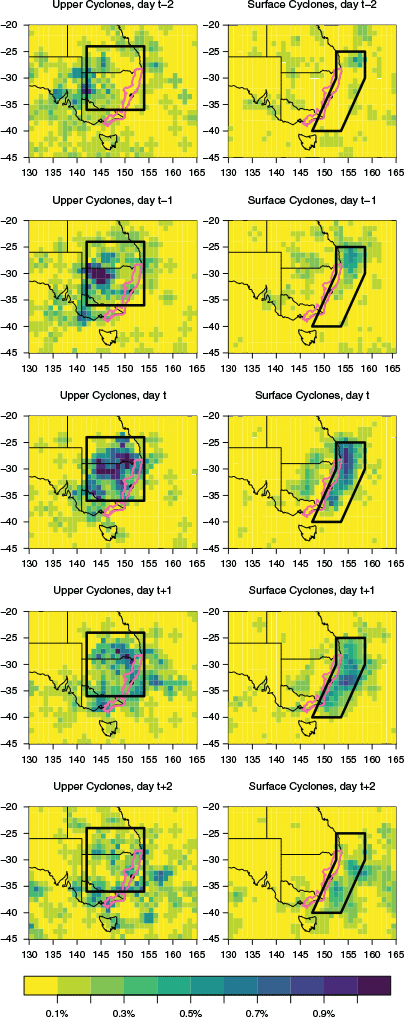
Fig. 1 shows the preferred location of cyclones identified at the surface and at 500 hPa on days with widespread heavy rainfall in the ESB. Surface lows that produce heavy rainfall are typically located near to the coast in the Tasman Sea, consistent with previous studies (Hopkins and Holland 1997). Consequently, the domain used for surface ECLs is similar to that in previous studies (Wiles et al. 2009; Browning and Goodwin 2013; Pepler et al. 2015) but is restricted in the east to include only lows within 6° of the coast, excluding those lows in the southeast Tasman that may cause strong winds or large waves but are unlikely to produce heavy coastal rainfall. Note that there is a small cluster of surface lows in inland New South Wales associated with widespread heavy rain, with 34 days per year recording an inland low over 25–40°S, 140–155°E but no low near the coast in our analysis. These would be considered ‘inland’ lows or troughs rather than ECLs based on most studies (e.g. Speer et al. 2009, Callaghan and Power 2014) and are not a focus of the analysis presented here, as while some cases can cause heavy coastal rainfall, they collectively explain less than 9% of ESB rainfall and have average ESB rainfall lower than any of the ECL categories discussed below.
The location of upper lows is typically to the west of the surface low, consistent with previous studies and the tendency for strong extratropical cyclones to tilt west with height. As a result, the domain used for upper ECLs is shifted to the north and west and is predominantly inland, with the final domain chosen by testing a range of latitude and longitude boundaries to identify the region for which the average ESB rain rate on days with an upper low was maximised. This was similar to the domain used in Dowdy et al. (2013b, 2014) but shifted to the west, consistent with the domain for surface lows, as ECLs further east are more likely to produce high sea levels and large waves than coastal precipitation. While the results presented in this paper may vary slightly for different domains, the overall results were generally consistent for small changes in boundaries.
Using these domains, we defined each day as having a surface and/or upper low based on whether a cyclone was located within the corresponding region at any point on the day. We also applied a number of intensity (Laplacian) thresholds (Table 1) to distinguish between weak and strong systems. The weakest threshold was set such that approximately 10% of days were considered as ECLs at each level, consistent with the frequency of ECLs in the manual ECL database, which is frequently used for calibrating automated cyclone datasets (Speer et al. 2009; Dowdy et al. 2013a). A stronger threshold was set such that there were 21 ECL days per year at each level, which was the average number of ECLs from the Speer et al. (2009) dataset in the more constrained surface region used in this study (Fig. 1), and a very strong threshold was chosen to give eight ECL days per year at each level, the number of cyclones with widespread rainfall in Speer et al. (2009).

|
In total, 65.7 days per year had either a surface or upper cyclone, and these days were responsible for 42.2% of total annual ESB rain and 82.7% of widespread heavy rain days. The average rain rate was consistently higher on days that had a cyclone at both the surface and upper levels, with higher rainfall intensities when there were strong cyclones at both levels. The relationship between intensity and rainfall was less clear when a low was identified only at a single level; notably, in the absence of an upper low, even a very strong surface cyclone produced relatively low surface rainfall, on average. Collectively, the 5.2 days per year where there was a strong or very strong cyclone at both the surface and upper levels explained 35% of heavy rain days and 42% of extreme rain days.
The average rain rate on days with a strong or very strong upper low and no surface low was higher than days with a strong or very strong surface low and no upper low. This was somewhat different to the general results from Pepler and Dowdy (2020) who found stronger rain rates for days with surface lows and no upper low than the converse. In particular, Pepler and Dowdy (2020) considered a cyclone to be deep if it is matched at any point during the cyclone track, which accounts for the fact that surface lows are typically observed later than the upper low (Fig. 2d) and the heaviest rainfall typically occurs while the system is intensifying, when the surface low may be too small to be detected from reanalyses (Hopkins and Holland 1997; Mills et al. 2010). There were 2.2 days per year with a strong upper low where either the subsequent or previous day could be considered deep; such days had an average rain rate of 12.2 mm, compared to 6.9 mm on the remaining upper-only days. Some of these remaining upper-only days were likely to have a coastal surface trough, or potentially a localised coastal low that was too small in scale to be identified using our tracking methods.

|
While acknowledging there is no perfect method to classify and select thresholds for these systems, we consider five subcategories of ECLs in this paper, as well as another category for days with no cyclone. Deep cyclones are considered to either have a cyclone of any intensity at both the surface and upper levels or have a strong or very strong cyclone present at one level and either the previous or subsequent day was considered a deep cyclone. This means that if there was a prolonged event with a strong upper cyclone, a single timestep with a weak surface low would be sufficient for the event to be considered a ‘deep’ cyclone, consistent with the approach in Pepler and Dowdy (2020).
On average, there were 6.6 deep events per year with an average duration of 2.2 days. The longest continuous events in our dataset were 6 days in duration, with this occurring on four occasions during the study period. For two of these four cases the low could only be continuously tracked at one level, while in the other two cases the upper and lower cyclones each persisted for at least 5 days of the event.
The remaining ECL days can be considered either ‘shallow surface’ or ‘shallow upper’ and those two criteria can be further subdivided into two categories each (i.e. corresponding to four of the categories considered in this study) for days with a weak cyclone or a strong/very strong cyclone at that level. Table 2 reports the ESB average rainfall statistics for these categories, highlighting that the 14.6 days per year with deep cyclones account for a larger number of days with moderate, heavy or extreme rainfall on the ESB than the 51 days per year corresponding to the four other cyclone categories combined. Strong upper-only cyclones also make a larger contribution to widespread heavy rain events than surface-only cyclones, highlighting that a large proportion of heavy rainfall on the ESB cannot be explained by weather systems identified at the surface alone, as well as noting the contribution from other phenomena, including fronts and thunderstorms (e.g. in Dowdy and Catto 2017; Pepler et al. 2020).

|
While the average rainfall on days without an ECL is substantially lower than even the weakest ECL day, more than half of all ESB rainfall occurs on such days, which is unsurprising given that ECLs occur less than 20% of the time. These days are likely to be influenced by a large range of other synoptic features, including inland lows or troughs, coastal troughs, moist onshore easterlies, such as those related to a high pressure system, and thunderstorm activity, particularly in the northern part of the ESB (e.g. Rakich et al. 2008; Pepler et al. 2020). In addition, it is likely that a large number of those ECLs identified as having widespread rainfall, including days with an upper low but no surface cyclone, coincide with widespread convection, as the most severe rainfall in southern Australia, including the east coast, is often associated with the combination of a cyclone and thunderstorm activity (Chambers et al. 2014; Dowdy and Catto 2017; Pepler and Dowdy 2020; Pepler et al. 2020).
Fig. 2 shows how the contribution of cyclones to both total and heavy rainfall varies across the ESB. Upper-only lows are particularly important in the coastal regions of the central and northern ESB and also during the cool half of the year, while shallow surface lows give a larger contribution to rainfall in the southern and inland ESB and during the warm half of the year. The relative contribution of ECLs to heavy rainfall is smaller when assessing locally extreme rainfall above the 99th percentile, where small-scale convection can play a larger role in extremes. While deep cyclones are responsible for 34% of days with rainfall above the 99th percentile in Eden and 38% of such days in Sydney, they explain only 25% of 99th percentile rain days in South West Rocks and 19% in Brisbane. At the latter two stations, upper-only cyclone collectively explain approximately 30% of 99th percentile days. This likely reflects the important role of 500 hPa geostrophic winds in the generation of heavy rainfall on days with prevailing onshore flow in these regions (Callaghan and Power 2017).
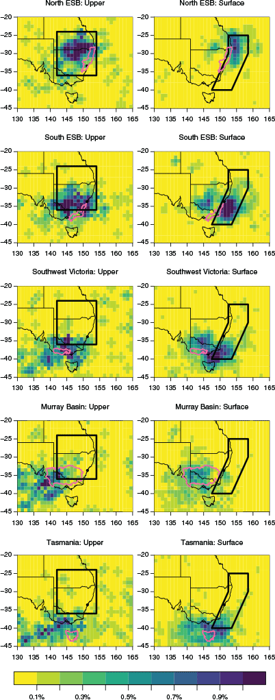
The different contributions of upper-only vs surface-only cyclones to different regions of the ESB are expected to be partially related to the regions used in identifying cyclone days, as the upper cyclone box is generally focused to the northwest of the ESB and away from the main midlatitude storm tracks. While this paper focuses on the ECLs associated with heavy rain along the ESB, the same approach can be used for identifying cyclones most relevant to different parts of the ESB, or indeed for other regions of southeast Australia (Fig. 3). Fig. 3 shows the locations of surface cyclones associated with heavy rainfall in the northern and southern parts of the ESB, with cyclones that affect the northern ESB tending to occur further north but at similar longitudes. While the regions used for identifying surface cyclones in this study captured the majority of cyclones affecting either region, a small number of upper cyclones affecting the southern ESB were to the south of the region used when defining ECLs in this paper. However, the total frequency of upper cyclones increased further south (Pepler and Dowdy 2020) and the majority of upper cyclones in this region had little impact on ESB rain, so tests found expanding the region towards the south made identifying heavy rain events more difficult.
|
Fig. 3 also shows cyclones affecting three additional regions of southeast Australia for comparison with the ESB. While surface cyclones affecting the ESB are concentrated in the maritime environment to the east of the coast, surface cyclones located over inland southeast Australia are more important in southwest Victoria and the Murray Basin, while Tasmanian rainfall is affected by cyclones over much of the surrounding oceans. Whereas upper cyclones are preferentially located to the west and north of the ESB regions, they are located to the west and south of the other regions used. Previous studies have found that upper cyclones, particularly lows that are cut off from the midlatitude westerlies, can be very important for rainfall in other parts of southeastern Australia, including Victoria (Risbey et al. 2013).
4 Trends and variability of cyclones
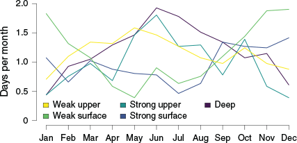
The total number of ECLs is broadly consistent over the years (Fig. 4a), with an interquartile range of 60–71 cyclone days per year. The lowest number of cyclone days on record was in 2019 (46 days), while the highest frequency on record was in 1985 (99 days). The total number of ECLs is also fairly consistent throughout the year, with deep cyclones and strong upper cyclones concentrated during the cool season (April–September) while shallow surface cyclones are more common during the warmer months, consistent with Pepler and Dowdy (2020), particularly those that are only identified using a weak intensity threshold (Fig. 5).

|
|
Past studies note several instances of multiple severe ECLs occurring in a single month, such as in June 2007 (Mills et al. 2010; Browning and Goodwin 2016), with such months causing particularly severe coastal impacts as a result of repeated heavy rainfall and coastal erosion. However, the numbers of deep ECL events per month in this study closely follow the Poisson distribution for a monthly mean frequency of 0.55 events, with 57.1% of months recording no ECLs (expected 57.7%) and 9.8% of months recording at least two ECLs (expected 10.6%). This is also the case for upper lows and surface lows, which also show no clear sign of temporal clustering different to random chance alone (i.e. no notable deviation from a Poisson distribution). While this does not negate the importance of those months where multiple events occur, it suggests that the occurrence of such months may be primarily due to chance, rather than any predisposition of ECLs to cluster. This is in contrast to the northern hemisphere storm tracks where certain conditions favour the development of large numbers of cyclones (Pinto et al. 2013).
The low interannual variability reflects much larger variations in the prevailing types of cyclones in each year, with only weak correlations between the overall frequency of surface vs upper cyclones (r = 0.28) and generally weak correlations between the five subcategories, including between strong and weak surface cyclones (r = 0.05) or between strong and weak upper cyclones (r = 0.26). This has also been identified using other methods of subcategorising ECLs, with seasons that have a high frequency of cyclones typically dominated by cyclones with a similar synoptic signature (Browning and Goodwin 2016; Kiem et al. 2016). The interannual variability of deep cyclones is particularly large, between 4 days in 1994 and 30 days in 1990. The larger role of deep cyclone days in heavy rainfall contributes to much larger interannual variability in the total rainfall from ECLs (Fig. 4b), with the interquartile range spanning 289–470 mm. The smallest contribution of ECLs to rainfall also occurred during 2019, when ECLs contributed only 172 mm of rainfall; this was the driest year for the ESB during the 1979–2019 period and had the fewest cyclones on record over a broader region of southern Australia (Pepler 2020).
There are no trends in the overall frequency of ECLs over the period 1979–2019 (Fig. 4), with the frequencies of each cyclone category in 2000–2019 very similar to 1980–1999. The exception is deep cyclones, which declined slightly in frequency from 15.1 days per year in 1980–1999 to 14.0 days per year between 2000–2019 (this is not statistically significant using a Student’s t-test). The decrease in deep cyclones primarily occurred during the spring (September–November), from 4.4 to 2.9 days per year (P = 0.1). There is also no detectable trend in the frequency of widespread heavy or extreme rainfall days during this period.
The strong interannual variability in the number of ECLs make trends difficult to determine, including for analysis such as presented here, based on recent decades of reanalysis data, as discussed in Dowdy et al. (2019) and references therein. Previous studies also considered a range of other data sources for earlier time periods (including observing station records, shipping logbooks, newspaper stories, etc.) for examining longer-term variations in cyclones and rainfall along eastern Australia. These studies have highlighted large multidecadal variability in the frequency of ECLs and related weather systems, including large numbers of ECL-related floods in the 1860s and 1950s and a decline in floods with tropical influences in recent decades (Power and Callaghan 2016; Gray et al. 2020). Large multidecadal variability has also been observed in heavy rainfall events (Ashcroft et al. 2019), which some studies have linked to the Interdecadal Pacific Oscillation (Speer 2008).
Fig. 6 shows the linear trends in all surface and upper cyclones in southeast Australia over the period 1979–2019. Trends in surface cyclones over this period are generally weakly negative in the region of interest, while there are areas of both increasing and decreasing frequency of upper cyclones. There are strong and statistically significant declining trends in upper cyclones in the southern part of the domain as well as further south; this region is of particular relevance to rain in southwest Victoria (Fig. 3), which has been experiencing long-term rainfall declines (Timbal and Drosdowsky 2013; Hope et al. 2017).

|
The weak relationships between the frequency of cyclones at different atmospheric levels, as well as between strong and weak cyclones at a given level, suggests that they may have differing relationships with major climate drivers. This may help to explain the varying relationships found between ECLs and ENSO in papers using a range of different datasets, and the weak relationship between ENSO and rainfall over the ESB during the cooler months (Pepler et al. 2014). To assess this, we calculated the correlations between cyclone frequency in each category for rolling three-month seasons against a range of climate indices (Fig. 7).

|
Consistent with earlier studies using similar approaches (Pepler et al. 2014, 2015), the relationship between tropical modes of climate variability and ECLs is relatively weak, noting that statistically significant correlations would be expected 5% of the time from chance alone. The strongest relationships are seen during the winter months (June–August), when La Niña and negative IOD are both associated with a slightly increased frequency of surface cyclones, including both deep and shallow days. Interestingly, while these drivers have weak correlations with the total number of upper cyclones (not shown), they are associated with fewer shallow upper cyclones during this season. This result could be because the increased frequency of surface cyclones during La Niña years is associated with an increase in the likelihood that an upper cyclone will be part of a deep event, thereby decreasing the number of shallow upper cyclones. The relationship between SAM and ECLs is also generally weak, but positive SAM is associated with an increased frequency of deep cyclones in August–October and of shallow upper cyclones in December–February, noting that SAM is associated with ENSO during the austral summer (Lim et al. 2013).
Similar results are also seen when we use composites to compare the frequency of ECLs between the positive and negative phase of ENSO and the IOD. There are no statistically significant differences in the overall number of ECLs between El Niño and La Niña years in any season, although the average frequency of deep cyclones is higher in La Niña winters (7.7 days) than El Niño (4.1) or neutral (4.8) winters (P = 0.02 using a t-test). Interestingly, the overall frequency of upper cyclones is lowest during the summer of ENSO-neutral years, with the opposite pattern observed for surface cyclones. There are also no differences in the total number of ECLs in any season between positive and negative IOD events, with positive IOD winters associated with fewer surface cyclones and more upper cyclones. While there is an overall decrease in deep cyclone days in positive IOD winters (3.8) compared to neutral (5.3) and negative (6.6) IOD winters, this is not statistically significant using a t-test (P = 0.09).
There are slightly stronger relationships between ECL frequency and indices that represent local circulation anomalies, including the strength and position of the local subtropical ridge and the prevalence of westerly or easterly winds (GDI). Interestingly, these indices frequently have opposing influences at the surface and upper levels, with a stronger or southward subtropical ridge and anomalously easterly winds (positive GDI) associated with an increased frequency of shallow upper cyclones and a decreased frequency of shallow surface cyclones, but generally weak correlations with the frequency of deep cyclones.
Fig. 8 shows the same correlations, but for the total rainfall associated with cyclones. While these results are broadly consistent with those shown in Fig. 7, there are some interesting points of difference; for instance, while La Niña and negative IOD years do not change the overall number of shallow surface cyclones during the spring, they increase the amount of rainfall these cyclones produce. Overall, correlations between climate indices and ECL-related rainfall remain weak, with total ECL rainfall most strongly associated with easterly winds (positive GDI) during the summer and autumn and with negative IOD during the winter and spring. In comparison, non-ECL rain is strongly correlated with SOI during the winter and spring, with a June–November correlation of +0.58.

|
5 Conclusions
ECLs are an important influence on the rainfall of the ESB, but the atmospheric levels and regions used to identify ECLs vary between studies (Speer et al. 2009; Browning and Goodwin 2013; Dowdy et al. 2013a; Pepler et al. 2015). By first identifying days with widespread heavy rainfall on the ESB, we were able to identify the regions where cyclones were most likely to produce heavy rainfall. The region used for surface cyclones was similar to that used in previous studies (Speer et al. 2009; Pepler et al. 2015) but was restricted to cyclones within 600 km of the east coast to focus on those that are more impactful on this heavily populated region, consistent with Hopkins and Holland (1997). This excludes the large number of cyclones further southeast, which can cause strong winds and large waves in ocean regions but cause limited rainfall on the coastal strip. The region used for upper (500 hPa) cyclones is to the northwest and centred over inland southeast Australia (24–36°S, 142–154°E), slightly west of the region identified by Dowdy et al. (2013a) of 25–35°S, 145–160°E.
Heavy rainfall is most likely in cases when ECLs are identifiable at the surface and upper level, which are called ‘deep’ cyclones. When this category is expanded to include days where a cyclone was at a single level but the previous or subsequent day is deep, to allow for different timing between the levels, such events occur on 14.6 days per year but explain 16.5% of annual rainfall, 27.4% of days with at least 25 mm of rain, and 52.7% of days that exceed the 99th percentile for the proportion of the ESB recording at least 50 mm. This is consistent with previous studies that identified that the most severe ECLs are typically associated with both a surface and upper cyclone (Mills et al. 2010; Dowdy et al. 2011; Pepler and Dowdy 2020).
When no upper cyclone was identified, the intensity of a surface cyclone, as measured by the average Laplacian of pressure, was only weakly associated with the intensity of rainfall on the east coast. In comparison, very strong upper-only cyclones produced twice as much rainfall on the ESB as weak upper-only cyclones, although it is important to note that many of these events developed a surface cyclone on the subsequent day. However, the heaviest rainfall was associated with deep cyclones, particularly when the cyclones at both levels were strong.
Shallow surface cyclones were found to be most important for rainfall in southern and inland regions, particularly during the warm season, while shallow upper cyclones were most important during the cool season and along the north and central coastline. While the region used for identifying upper cyclones was selected to optimise the identification of lows with heavy rain on the ESB as a whole, it is possible that some of these shallow surface cyclones in the southern region may be associated with upper lows located to the south of our region, so results will be somewhat sensitive to the domains chosen.
Shallow upper cyclones were more likely to produce heavy rainfall than shallow surface cyclones, in contrast to results from Pepler and Dowdy (2020); this is partially related to the different approaches used for identifying upper cyclones, including the use of daily averaged geopotential height in this study, which excludes those fast-moving shallow systems that produce little rainfall, as well as the different domains used between the studies (with the domain selected here specifically for relevance to rainfall events in the ESB region). Some shallow upper systems may also be associated with coastal troughs or very small/transient surface cyclones near the coast, which may not be detected in our analysis.
While distinguishing between deep and shallow systems helps shed some light on the drivers of ECLs and associated rainfall, the correlation with climate drivers is generally weak. This is consistent with previous studies that assessed links between ECLs identified from synoptic characteristics and climate drivers (Pepler et al. 2014, 2015) but differs from studies focused on ECL-related impacts, such as heavy rainfall and widespread flooding (Power and Callaghan 2016). This may suggest a role of La Niña in other factors that increase the likelihood that a severe ECL will cause flooding, such as moisture availability for heavy rainfall, catchment wetness and preconditioning from other rain events, or changes in the location or small-scale characteristics of ECL-related rainfall.
The period 1979–2019 is also too short for statistically significant trends to emerge, especially given the large interannual variability in ECL numbers, although there are indications of a slight decline in deep cyclones as well as in upper cyclones to the south of the region. This is consistent with model projections of future declines in ECLs, particularly upper systems (Dowdy et al. 2013b, 2014; Pepler et al. 2016a). Trends in the frequency of cyclones that produce heavy rain also do not necessarily imply a trend in the frequency of heavy rain events, as the intensity of systems can also change; over the period of interest there was no change in the frequency of widespread heavy rain events on the ESB.
While this paper focuses on cyclones most relevant to the ESB, the cyclones of greatest importance to rainfall vary across southeast Australia, with inland surface lows as well as upper cyclones to the south and west playing an important role for rainfall in areas in southeast Australia that have experienced long-term rainfall declines (Murphy and Timbal 2008; Risbey et al. 2013). Future research will further investigate the role of upper cyclones on rainfall in these regions and how the observed declines in upper cyclones may interact with surface cyclones to explain long-term rainfall trends.
Conflicts of interest
The authors declare no conflicts of interest.
Declaration of funding
This project was funded by the Earth Systems and Climate Change Hub of the Australian Government’s National Environmental Science Program and was assisted by resources from the Australian National Computational Infrastructure.
Acknowledgements
The authors would like to thank Pandora Hope, Graham Mills, David Jones and two anonymous reviewers for their helpful comments on this paper.
References
Allen, J. T., Pezza, A. B., and Black, M. T. (2010). Explosive cyclogenesis: A global climatology comparing multiple reanalyses. J. Clim. 23, 6468–6484.| Explosive cyclogenesis: A global climatology comparing multiple reanalyses.Crossref | GoogleScholarGoogle Scholar |
Ashcroft, L., Karoly, D. J., and Dowdy, A. J. (2019). Historical extreme rainfall events in southeastern Australia. Wea. Clim. Extrem. 25, 100210.
| Historical extreme rainfall events in southeastern Australia.Crossref | GoogleScholarGoogle Scholar |
Browning, S. A., and Goodwin, I. D. (2013). Large-Scale Influences on the Evolution of Winter Subtropical Maritime Cyclones Affecting Australia’s East Coast. Mon. Wea. Rev. 141, 2416–2431.
| Large-Scale Influences on the Evolution of Winter Subtropical Maritime Cyclones Affecting Australia’s East Coast.Crossref | GoogleScholarGoogle Scholar |
Browning, S., and Goodwin, I. (2016). Large-scale drivers of Australian east coast cyclones since 1851. J. South. Hemisph. Earth Syst. Sci. 66, 125–151.
| Large-scale drivers of Australian east coast cyclones since 1851.Crossref | GoogleScholarGoogle Scholar |
Callaghan, J., and Power, S. (2014). Major coastal flooding in southeastern Australia, associated deaths and weather systems. Aust. Meteorol. Oceanogr. J. 64, 183–213.
| Major coastal flooding in southeastern Australia, associated deaths and weather systems.Crossref | GoogleScholarGoogle Scholar |
Callaghan, J., and Power, S. (2017). A vertical wind structure that leads to extreme rainfall and major flooding in southeast Australia. J. South. Hemisph. Earth Syst. Sci. 66, 380–401.
| A vertical wind structure that leads to extreme rainfall and major flooding in southeast Australia.Crossref | GoogleScholarGoogle Scholar |
Cavicchia, L., Pepler, A., Dowdy, A., and Walsh, K. (2019). A Physically Based Climatology of the Occurrence and Intensification of Australian East Coast Lows. J. Clim. 32, 2823–2841.
| A Physically Based Climatology of the Occurrence and Intensification of Australian East Coast Lows.Crossref | GoogleScholarGoogle Scholar |
Chambers, C. R. S., Chambers, C. R. S., Brassington, G. B., Simmonds, I., and Walsh, K. (2014). Precipitation changes due to the introduction of eddy-resolved sea surface temperatures into simulations of the “Pasha Bulker” Australian east coast low of June 2007. Meteorol. Atmos. Phys. 125, 1–15.
| Precipitation changes due to the introduction of eddy-resolved sea surface temperatures into simulations of the “Pasha Bulker” Australian east coast low of June 2007.Crossref | GoogleScholarGoogle Scholar |
Di Luca, A., Evans, J. P., Pepler, A., Alexander, L., and Argüeso, D. (2015). Resolution sensitivity of cyclone climatology over Eastern Australia using six reanalysis products. J. Clim. 28, 9530–9549.
| Resolution sensitivity of cyclone climatology over Eastern Australia using six reanalysis products.Crossref | GoogleScholarGoogle Scholar |
Dowdy, A. J., and Catto, J. L. (2017). Extreme weather caused by concurrent cyclone, front and thunderstorm occurrences. Sci. Rep. 7, srep40359.
| Extreme weather caused by concurrent cyclone, front and thunderstorm occurrences.Crossref | GoogleScholarGoogle Scholar |
Dowdy, A. J., G. A. Mills, and B. Timbal, (2011). Large-scale indicators of Australian East Coast Lows and associated extreme weather events. CAWCR Technical Report No. 037. Centre for Australian Weather and Climate Research. 104 pp. Available at https://www.cawcr.gov.au/technical-reports/CTR_037.pdf
Dowdy, A. J., Mills, G. A., and Timbal, B. (2013a). Large-scale diagnostics of extratropical cyclogenesis in eastern Australia. Int. J. Climatol. 33, 2318–2327.
| Large-scale diagnostics of extratropical cyclogenesis in eastern Australia.Crossref | GoogleScholarGoogle Scholar |
Dowdy, A. J., Ga, M., Timbal, B., Griffiths, M., and Wang, Y. (2013b). Understanding rainfall projections in relation to extratropical cyclones in eastern Australia. Aust. Meteorol. Oceanogr. J. 63, 355–364.
| Understanding rainfall projections in relation to extratropical cyclones in eastern Australia.Crossref | GoogleScholarGoogle Scholar |
Dowdy, A. J., Mills, G. A., Timbal, B., and Wang, Y. (2014). Fewer large waves projected for eastern Australia due to decreasing storminess. Nat. Clim. Chang. 4, 283–286.
| Fewer large waves projected for eastern Australia due to decreasing storminess.Crossref | GoogleScholarGoogle Scholar |
Dowdy, A. J., Pepler, A., Di Luca, A., et al. (2019). Review of Australian east coast low pressure systems and associated extremes. Clim. Dyn. 53, 4887–4910.
| Review of Australian east coast low pressure systems and associated extremes.Crossref | GoogleScholarGoogle Scholar |
Drosdowsky, W. (2005). The latitude of the subtropical ridge over Eastern Australia: The L index revisited. Int. J. Climatol. 25, 1291–1299.
| The latitude of the subtropical ridge over Eastern Australia: The L index revisited.Crossref | GoogleScholarGoogle Scholar |
Gray, J. L., Verdon-Kidd, D. C., Callaghan, J., and English, N. B. (2020). On the recent hiatus of tropical cyclones landfalling in NSW, Australia. J. South. Hemisph. Earth Syst. Sci. 70, 180–192.
| On the recent hiatus of tropical cyclones landfalling in NSW, Australia.Crossref | GoogleScholarGoogle Scholar |
Hart, R. E. (2003). A Cyclone Phase Space Derived from Thermal Wind and Thermal Asymmetry. Mon. Wea. Rev. 131, 585–616.
| A Cyclone Phase Space Derived from Thermal Wind and Thermal Asymmetry.Crossref | GoogleScholarGoogle Scholar |
Hawcroft, M. K., Shaffrey, L. C., Hodges, K. I., and Dacre, H. F. (2012). How much Northern Hemisphere precipitation is associated with extratropical cyclones? Geophys. Res. Lett. 39, L24809.
| How much Northern Hemisphere precipitation is associated with extratropical cyclones?Crossref | GoogleScholarGoogle Scholar |
Hersbach, H., Bell, B., Berrisford, P., et al. (2020). The ERA5 Global Reanalysis. Quart. J. Roy. Meteor. Soc. 146, 1999–2049.
| The ERA5 Global Reanalysis.Crossref | GoogleScholarGoogle Scholar |
Hope, P., Timbal, B., Hendon, H., Ekström, M., and Potter, N. (2017). A Synthesis of Findings from the Victorian Climate Initiative (VicCI). Bureau of Meteorology, Australia. 56pp.
Hopkins, L. C., and Holland, G. J. (1997). Australian heavy-rain days and associated east coast cyclones: 1958-92. J. Clim. 10, 621–634.
| Australian heavy-rain days and associated east coast cyclones: 1958-92.Crossref | GoogleScholarGoogle Scholar |
Jones, D. A., Wang, W., and Fawcett, R. (2009). High-quality spatial climate data-sets for Australia. Aust. Meteorol. Oceanogr. J. 58, 233–248.
| High-quality spatial climate data-sets for Australia.Crossref | GoogleScholarGoogle Scholar |
Kiem, A. S., Twomey, C., Lockart, N., Willgoose, G., Kuczera, G., Chowdhury, A. F. M. K., Manage, N. P., and Zhang, L. (2016). Links between East Coast Lows and the spatial and temporal variability of rainfall along the eastern seaboard of Australia. J. South. Hemisph. Earth Syst. Sci. 66, 162–176.
| Links between East Coast Lows and the spatial and temporal variability of rainfall along the eastern seaboard of Australia.Crossref | GoogleScholarGoogle Scholar |
King, A. D., Alexander, L. V., and Donat, M. G. (2013). The efficacy of using gridded data to examine extreme rainfall characteristics: a case study for Australia. Int. J. Climatol. 33, 2376–2387.
| The efficacy of using gridded data to examine extreme rainfall characteristics: a case study for Australia.Crossref | GoogleScholarGoogle Scholar |
Lim, E.-P., and Simmonds, I. (2007). Southern hemisphere winter extratropical cyclone characteristics and vertical organization observed with the ERA-40 data in 1979-2001. J. Clim. 20, 2675–2690.
| Southern hemisphere winter extratropical cyclone characteristics and vertical organization observed with the ERA-40 data in 1979-2001.Crossref | GoogleScholarGoogle Scholar |
Lim, E.-P. P., Hendon, H. H., and Rashid, H. (2013). Seasonal predictability of the southern annular mode due to its association with ENSO. J. Clim. 26, 8037–8054.
| Seasonal predictability of the southern annular mode due to its association with ENSO.Crossref | GoogleScholarGoogle Scholar |
McInnes, K. L., and Hubbert, G. D. (2001). The impact of eastern Australian cut-off lows on coastal sea levels. Meteorol. Appl. 8, 229–243.
| The impact of eastern Australian cut-off lows on coastal sea levels.Crossref | GoogleScholarGoogle Scholar |
Mills, G. A., Webb, R., Davidson, N. E., Kepert, J., Seed, A., and Abbs, D. (2010). The Pasha Bulker east coast low of 8 June (2007). CAWCR Technical Report No. 023. Centre for Australian Weather and Climate Research. 74 pp. Available at https://www.cawcr.gov.au/technical-reports/CTR_023.pdf
Murphy, B. F., and Timbal, B. (2008). A review of recent climate variability and climate change in southeastern Australia. Int. J. Climatol. 28, 859–879.
| A review of recent climate variability and climate change in southeastern Australia.Crossref | GoogleScholarGoogle Scholar |
Murray, R. J., and Simmonds, I. (1991). A numerical scheme for tracking cyclone centres from digital data. Part I: Development and operation of the scheme. Aust. Meteorol. Mag. 39, 155–166.
Neu, U., Akperov, M. G., Bellenbaum, N., et al. (2013). Imilast: A community effort to intercompare extratropical cyclone detection and tracking algorithms. Bull. Amer. Meteor. Soc. 94, 529–547.
| Imilast: A community effort to intercompare extratropical cyclone detection and tracking algorithms.Crossref | GoogleScholarGoogle Scholar |
Pepler, A. (2020). Record Lack of Cyclones in Southern Australia During 2019. Geophys. Res. Lett. 47, .
| Record Lack of Cyclones in Southern Australia During 2019.Crossref | GoogleScholarGoogle Scholar |
Pepler, A. S., and Rakich, C. S. (2010). Extreme inflow events and synoptic forcing in Sydney catchments. IOP Conf. Ser. Earth Environ. Sci. 11, 12010.
| Extreme inflow events and synoptic forcing in Sydney catchments.Crossref | GoogleScholarGoogle Scholar |
Pepler, A., and Coutts-Smith, A. (2013). A new, objective, database of East Coast Lows. Aust. Meteorol. Oceanogr. J. 63, 461–472.
| A new, objective, database of East Coast Lows.Crossref | GoogleScholarGoogle Scholar |
Pepler, A., and Dowdy, A. (2020). A Three-Dimensional Perspective on Extratropical Cyclone Impacts. J. Clim. 33, 5635–5649.
| A Three-Dimensional Perspective on Extratropical Cyclone Impacts.Crossref | GoogleScholarGoogle Scholar |
Pepler, A., Coutts-Smith, , and Timbal, B. (2014). The role of East Coast Lows on rainfall patterns and inter-annual variability across the East Coast of Australia. Int. J. Climatol. 34, 1011–1021.
| The role of East Coast Lows on rainfall patterns and inter-annual variability across the East Coast of Australia.Crossref | GoogleScholarGoogle Scholar |
Pepler, A. S., Di Luca, A., Ji, F., Alexander, L. V., Evans, J. P., and Sherwood, S. C. (2015). Impact of Identification Method on the Inferred Characteristics and Variability of Australian East Coast Lows. Mon. Wea. Rev. 143, 864–877.
| Impact of Identification Method on the Inferred Characteristics and Variability of Australian East Coast Lows.Crossref | GoogleScholarGoogle Scholar |
Pepler, A. S., Di Luca, A., Ji, F., et al. (2016a). Projected changes in east Australian midlatitude cyclones during the 21st century. Geophys. Res. Lett. 43, 334–340.
| Projected changes in east Australian midlatitude cyclones during the 21st century.Crossref | GoogleScholarGoogle Scholar |
Pepler, A. S., Imielska, A., Coutts-Smith, A., Gamble, F., and Schweitzer, M. (2016b). Identifying East Coast Lows with climate hazards on the eastern seaboard. J. South. Hemisph. Earth Syst. Sci. 66, 97–107.
| Identifying East Coast Lows with climate hazards on the eastern seaboard.Crossref | GoogleScholarGoogle Scholar |
Pepler, A. S., Di Luca, A., and Evans, J. P. (2018). Independently assessing the representation of midlatitude cyclones in high-resolution reanalyses using satellite observed winds. Int. J. Climatol. 38, 1314–1327.
| Independently assessing the representation of midlatitude cyclones in high-resolution reanalyses using satellite observed winds.Crossref | GoogleScholarGoogle Scholar |
Pepler, A. S., Dowdy, A. J., van Rensch, P., Rudeva, I., Catto, J. L., and Hope, P. (2020). The contributions of fronts, lows and thunderstorms to southern Australian rainfall. Clim. Dyn. 55, 1489–1505.
| The contributions of fronts, lows and thunderstorms to southern Australian rainfall.Crossref | GoogleScholarGoogle Scholar |
Pfahl, S., and Wernli, H. (2012). Quantifying the relevance of cyclones for precipitation extremes. J. Clim. 25, 6770–6780.
| Quantifying the relevance of cyclones for precipitation extremes.Crossref | GoogleScholarGoogle Scholar |
Pinto, J. G., Bellenbaum, N., Karremann, M. K., and Della-Marta, P. M. (2013). Serial clustering of extratropical cyclones over the North Atlantic and Europe under recent and future climate conditions. J. Geophys. Res. Atmos. 118, 12476–12485.
| Serial clustering of extratropical cyclones over the North Atlantic and Europe under recent and future climate conditions.Crossref | GoogleScholarGoogle Scholar |
Power, S. B., and Callaghan, J. (2016). Variability in severe coastal flooding, associated storms, and death tolls in Southeastern Australia since the mid-nineteenth century. J. Appl. Meteorol. Climatol. 55, 1139–1149.
| Variability in severe coastal flooding, associated storms, and death tolls in Southeastern Australia since the mid-nineteenth century.Crossref | GoogleScholarGoogle Scholar |
Quinting, J. F., Catto, J. L., and Reeder, M. J. (2019). Synoptic climatology of hybrid cyclones in the Australian region. Quart. J. Roy. Meteor. Soc. 145, 288–302.
| Synoptic climatology of hybrid cyclones in the Australian region.Crossref | GoogleScholarGoogle Scholar |
Rakich, C. S., Holbrook, N. J., and Timbal, B. (2008). A pressure gradient metric capturing planetary-scale influences on eastern Australian rainfall. Geophys. Res. Lett. 35, .
| A pressure gradient metric capturing planetary-scale influences on eastern Australian rainfall.Crossref | GoogleScholarGoogle Scholar |
Risbey, J. S., Mcintosh, P. C., and Pook, M. J. (2013). Synoptic components of rainfall variability and trends in southeast Australia. Int. J. Climatol. 33, 2459–2472.
| Synoptic components of rainfall variability and trends in southeast Australia.Crossref | GoogleScholarGoogle Scholar |
Shand, T., I. D. Goodwin, M. A. Mole, J. T. Carley, S. A. Browning, I. R. Coghlan, M. D. Harley, and L. W. Peirson, (2011). NSW coastal inundation hazard study: Coastal storms and extreme wave events. WRL Technical Report 2010/16. 45 pp. Available at https://www.environment.nsw.gov.au/-/media/OEH/Corporate-Site/Documents/Research/Our-science-and-research/nsw-coastal-storms-extreme-waves-technical-report.pdf
Simmonds, I., Murray, R. J., and Leighton, R. M. (1999). A refinement of cyclone tracking methods with data from FROST. Aust. Meteorol. Mag. , 35–49.
Speer, M. S. (2008). On the late twentieth century decrease in Australian east coast rainfall extremes. Atmos. Sci. Lett. 9, 160–170.
| On the late twentieth century decrease in Australian east coast rainfall extremes.Crossref | GoogleScholarGoogle Scholar |
Speer, M., Wiles, P., and Pepler, A. (2009). Low pressure systems off the New South Wales coast and associated hazardous weather: establishment of a database. Aust. Meteorol. Oceanogr. J. 58, 29–39.
| Low pressure systems off the New South Wales coast and associated hazardous weather: establishment of a database.Crossref | GoogleScholarGoogle Scholar |
Tilinina, N., Gulev, S. K., Rudeva, I., and Koltermann, P. (2013). Comparing cyclone life cycle characteristics and their interannual variability in different reanalyses. J. Clim. 26, 6419–6438.
| Comparing cyclone life cycle characteristics and their interannual variability in different reanalyses.Crossref | GoogleScholarGoogle Scholar |
Timbal, B. (2010). The climate of the Eastern Seaboard of Australia: A challenging entity now and for future projections. IOP Conf. Ser. Earth Environ. Sci. 11, 12013.
| The climate of the Eastern Seaboard of Australia: A challenging entity now and for future projections.Crossref | GoogleScholarGoogle Scholar |
Timbal, B., and Drosdowsky, W. (2013). The relationship between the decline of Southeastern Australian rainfall and the strengthening of the subtropical ridge. Int. J. Climatol. 33, 1021–1034.
| The relationship between the decline of Southeastern Australian rainfall and the strengthening of the subtropical ridge.Crossref | GoogleScholarGoogle Scholar |
Wiles, P., A. Pepler, and M. S. Speer, (2009). Inter-annual variability in Australian East Coast Lows and its relation with key climatic indices. In ‘9th International Conference on Southern Hemisphere Meteorology and Oceanography’, Melbourne, Australia, 9–13 February 2009.