
Past and future coastal flooding in Pacific Small-Island Nations: insights from the Pacific Sea Level and Geodetic Monitoring (PSLGM) Project tide gauges
Mathilde Ritman A B * , Ben Hague A C , Tauala Katea D , Tavau Vaaia D , Arona Ngari E , Grant Smith A , David Jones A and Léna Tolu F
A Climate and Oceans Support Program in the Pacific, Australian Bureau of Meteorology, Melbourne, Vic., Australia.
B School of Mathematics, Monash University, Melbourne, Vic., Australia.
C School of Earth, Atmosphere and Environment, Monash University, Melbourne, Vic., Australia.
D Tuvalu Meteorological Service, Fongafale, Funafuti, Tuvalu.
E Cook Islands Meteorological Service, Avarua District, Rarotonga, Cook Islands.
F École Nationale de la Météorologie, Toulouse, France.
Abstract
Sea level rise is increasing the frequency of coastal flooding globally, and low-lying communities are particularly vulnerable. We present an assessment of historical and projected changes in coastal flooding in 11 Pacific small-island nations, using tide gauge data from the Australian Bureau of Meteorology. We derive impact-, event- and percentile-based thresholds to calculate historical exceedance frequencies. Projections of future exceedance frequencies are then made using the recent suite of Shared Socioeconomic Pathways (SSPs) emission scenarios (Sixth Assessment Report). We find that exceedances of the percentile thresholds have increased in the last decade at all locations, with sites seeing exceedances in months where exceedances were previously rare or unseen in the sea level record. In the future, daily threshold exceedances occur after 50–115 cm of sea level rise, depending on location. Such levels are currently projected to be reached between 2080 and 2130 according to high emissions scenario SSP5–8.5. Low emissions scenario, SSP1–1.9, shows sea level rise resulting in 25–75 days of exceedances by 2050 for the 11 locations. This increased frequency of coastal flooding highlights the changing nature of coastal flood risk in the Pacific, with extreme weather and wave events being increasingly unnecessary for inundation to occur. Further, this work highlights how underlying increases in coastal flooding frequency pose a growing risk of exacerbating inundation associated with extreme weather or waves. Better flood monitoring and reporting will improve the accuracy of impact thresholds, strengthening the relevance of the results presented here for coastal emergency and planning managers.
Keywords: climate change, Cook Islands, flooding, nuisance flooding, Pacific, sea level rise, tidal flooding, tides, Tuvalu.
1.Introduction
Sea level rise (SLR) is accelerating around the world due to global warming, and low-lying communities such as those on Pacific Islands are particularly vulnerable (Oppenheimer et al. 2019). The relationship between increasing mean sea levels and increasing frequency of sea level extremes is well-established (Woodworth et al. 2011; Hague et al. 2022), and many studies (e.g. Buchanan et al. 2017; Wahl et al. 2017; Sweet et al. 2020) have estimated changes in extreme sea levels likely to be experienced in the future. Of the ~10 cm rise that has occurred globally since 1970 (Rasmussen et al. 2018), more than two-thirds is attributed to anthropogenic climate change (Slangen et al. 2016). However, fewer studies have investigated the extent to which this SLR has increased the frequency of coastal flooding in recent decades (e.g. Lin et al. 2014; Smith and Juria 2019).
Although present-day impacts of tide-driven flooding globally are generally a nuisance or minor in impact (Moftakhari et al. 2018; Hague et al. 2022), future SLR may mean that tides exceed levels currently only reached when extreme weather-induced storm surges combine with high tides (Dowdy and Kuleshov 2012; Needham et al. 2015). These events, where coastal flood thresholds are exceeded by tides alone, are rapidly becoming commonplace across the United States (Thompson et al. 2021) and Australia (Hague et al. 2022), and may result in annual economic impacts equivalent to weather-driven extreme sea levels in the future (Moftakhari et al. 2017; Ghanbari et al. 2021).
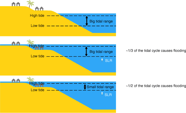
Persistent flood hazards in the equatorial Pacific are typically driven by tides and mean sea level variability (such as that associated with the El Niño–Southern Oscillation, ENSO), with some nations, including Vanuatu, Samoa and the Cook and Solomon Islands, experiencing non-trivial contributions from tropical cyclones (Rueda et al. 2017; Sweet et al. 2020). Importantly, this does not mean that the risk of coastal flooding due to tropical cyclones is insignificant in other regions, rather that as sea levels rise, and tide-driven flooding becomes chronic, tidal processes will increasingly play a bigger role in causing damaging coastal flooding than tropical cyclones. Compared to surge-dominated (defined in Table 1) locations elsewhere in the world, these tide-dominated (defined in Table 1) locations are more likely to experience a rapid increase in coastal extremes because of the smaller range of still water levels (defined in Table 1) experienced at these locations (Vitousek et al. 2017). This is especially true for locations where tidal ranges (defined in Table 1) are smaller (Sweet et al. 2020). Despite this, many Pacific coastal flood studies focus predominantly on extreme sea levels due to waves and storm surges (e.g. McInnes et al. 2016; Hoeke et al. 2021). Although many studies and reports have noted the vulnerability of Pacific nations to coastal flooding (e.g. Oppenheimer et al. 2019; Sweet et al. 2022), few have investigated how changes in frequency of coastal floods are evolving, and will continue to evolve, with rising sea levels. In many cases, analysis has been limited to the definition of extreme sea level return periods and the amplification factors thereof (Buchanan et al. 2017; Wahl et al. 2017; Sweet et al. 2020).
| Absolute sea level | Height of the ocean above the centre of the earth | |
| Relative sea level | Height of the ocean relative to the land at a given location | |
| Still water level | Sea level that would be observed in the absence of waves and swell. Here this is taken as the water level recorded by a tide gauge | |
| Predicted tide | An estimate of the water level under average weather, ocean and climate conditions obtained from harmonic analysis of tide gauge data | |
| LAT | Lowest historical predicted tide over a defined 20-year period | |
| HAT | Highest historical predicted tide over a defined 20-year period | |
| Tidal range | Difference between high and low tides, here defined as the difference between HAT and LAT | |
| Flood threshold | A critical still water level that, when exceeded, serves as a proxy for the occurrence of flood impacts in low-lying regions near the tide gauge | |
| Coastal flood day | A 24-h period (here, beginning at 0000 hours UTC) where the observed water level exceeds a flood threshold for at least one hourly observation | |
| Tide-sufficient | A coastal flood day where the predicted tide also exceeds the coastal flood threshold for at least one hourly observation | |
| Surge-driven | Exceedance of a flood threshold that occurs due to the non-tidal variations, and where the daily highest predicted tide remains below the flood threshold | |
| King tide | Term for a particularly high spring tide, often associated with flooding | |
| Skew surge | Difference between daily maximum water level and daily maximum predicted tide | |
| Freeboard | Distance between high tide levels and the flood threshold, e.g. where freeboard is positive, it represents minimum skew surge required for flooding to be observed | |
| Storminess factor | Ratio of the 99th percentile of skew surge to tidal range |
More recently, Sweet et al. (2020) derived flood thresholds for some Pacific islands using the 98th percentile of daily maximum sea levels combined with typical elevation offsets between minor and moderate flood thresholds from the continental United States. This approach, although it can capture frequent tide-driven flooding, still assumes that coastal floods occur at the same frequency across large spatial domains. In the Australian and United States contexts (Hague et al. 2020, 2022; Sweet et al. 2022), large spatial variations in coastal flood frequency mean that such percentile- or likelihood-based approaches can lead to large misestimations in coastal flood risk. Through the definition of an impact-based threshold for Tuvalu, we show that this is also true of the Pacific region. For example, flooding due to still water levels (without coincident large swell) is presently much rarer in the Marshall Islands (Smith and Juria 2019) than in Tuvalu (see Section 4). We further investigate how this relative flood risk between different locations in the Pacific changes as sea levels rise.
The Pacific Sea Level and Geodetic Monitoring (PSLGM) Project operates tide gauges in 13 Pacific nations (http://www.bom.gov.au/pacific/projects/pslm/). Many of these tide gauges have been recording still water levels since 1993, with co-located Global Navigation Satellite System (GNSS) receivers providing information on how land motion may be increasing or decreasing SLR locally. Although the computation of absolute (i.e. with respect to the centre of the earth) sea level is ongoing for PSLGM, it is the change in the relative sea level (defined in Table 1) that is most closely associated with coastal flooding (Karegar et al. 2017; Nicholls et al. 2021), and our focus here. Changes in relative sea level capture land motion, meaning vertical land motion information helps explain and contextualise changes in coastal flood frequencies in locations affected by rapid subsidence or uplift.
As noted by Hague et al. (2022), information on the height at which coastal flooding impacts of concern occur is essential to fully consider coastal flood impacts and risk. The impact information can be obtained through a variety of means. Citizen science monitoring programs (Harley et al. 2019; University of Hawai’i Sea Grant College Program 2021, https://seagrant.soest.hawaii.edu/coastal-and-climate-science-and-resilience/ccs-projects/hawaii-pacific-islands-king-tides-project/), the aggregation of social media posts (Fohringer et al. 2015; Moore and Obradovich 2020) and news articles (Smith and Juria 2019), as well as impact-verified digital elevation models (Wandres et al. 2020), have all been used to provide impact-based input into coastal risk studies in the Pacific. Direct engagement with national meteorological services, government departments or in-country disaster or development agencies is also an important avenue to get insights into the impacts of concern to local communities (Hoeke et al. 2021).
Here, we demonstrate that collaboration with the Tuvalu and Cook Islands meteorological services and the use of their monitoring efforts can deliver insights on coastal flood risk than have not yet been obtained using alternative methods, such as numerical modelling or statistical thresholds (McInnes et al. 2016; Wandres et al. 2020). This impact-based, direct engagement approach allows for the first known regional Pacific study specifically focused on tide-driven flooding events. Highlighting the potential value of future investment in engagement and monitoring programs to define such thresholds Pacific-wide. We also discuss how increasing sea levels may lead to an increase in events where other factors compound the flood risk hazards, such as heavy rainfall or large distant-source swells. Using the impact-, event- and percentile-based thresholds, we also present projections of future exceedance frequencies, according to various SLR projection scenarios (e.g. Sweet et al. 2017; Oppenheimer et al. 2019; Fox-Kemper et al. 2021). In doing so, we demonstrate how tide-driven flooding is likely to evolve at each location over the coming decades.
2.Methods
2.1. Tide gauge data
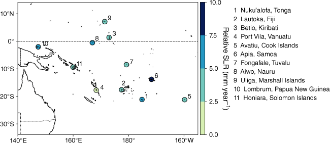
Hourly tide gauge data are taken from the Bureau of Meteorology’s PSLGM Project (http://www.bom.gov.au/oceanography/projects/spslcmp/data/index.shtml, accessed 11 February 2022). This project aims to generate an accurate record of variance in long-term sea level for the Pacific region and operates tide gauges in the South Pacific nations of Papua New Guinea, Solomon Islands, Vanuatu, Fiji, Tonga, Niue, Cook Islands, Samoa, Tuvalu, Palau and Nauru, as well as the Federated States of Micronesia (FSM), Kiribati and Marshall Islands in the North Pacific (Fig. 1). A minimum of 20 years of tide gauge data are required for climatological and tidal analysis – this is needed to capture the effects of the 18.61-year lunar nodal cycle which represents the varying declination of the moon (World Meteorological Organization 2017; Haigh et al. 2020). Of the 13 sites, 11 have sufficient data to be included in this research. This requirement excludes Niue and FSM from our analysis.
Tide gauge locations of the 11 sites considered in this research. Relative sea level rise is shown for each location.
The tide gauges whose data are used in this study are located in bays and harbours, meaning they are sheltered from the influence of swell, waves and other wind-driven processes. They are also taken at hourly frequency, a frequency at which the effects of these processes are not well observed. Thus, we assume the effects of swell, waves and other wind-driven processes are negligible, and that our still water level measurements instead capture largely the effects of tides, sea level variability, storm surges, SLR and vertical land motion. This means that our findings may not necessarily be valid for open coasts where the contribution of these processes to observed water levels are greater.
Observed SLR results, relative to the full tide gauge record at each of the 11 locations, are taken from the PSLGM project. These are determined by calculating the simple linear slope during the tidal analysis of all the quality-controlled data available at each station. Relative SLR rates for each site (Fig. 1) are shown in Table 2.
| Location | Record start date | Relative SLR (mm year–1) | Tidal range (m) | Storminess factor (dimensionless) | |
|---|---|---|---|---|---|
| 1. Nuku’Alofa, Tonga | 1993 | 6.8 | 1.8 | 0.061 | |
| 2. Lautoka, Fiji | 1992 | 3.7 | 2.3 | 0.037 | |
| 3. Betio, Kiribati | 1993 | 3.9 | 2.5 | 0.051 | |
| 4. Port Vila, Vanuatu | 1993 | 0.5 | 1.6 | 0.063 | |
| 5. Avatiu, Cook Islands | 1993 | 4.2 | 1.0 | 0.11 | |
| 6. Apia, Samoa | 1993 | 10.3 | 1.4 | 0.056 | |
| 7. Fongafale, Tuvalu | 1993 | 4.7 | 2.4 | 0.04 | |
| 8. Aiwo, Nauru | 1993 | 5.4 | 2.4 | 0.064 | |
| 9. Uliga, Marshall Islands | 1993 | 4.8 | 2.2 | 0.054 | |
| 10. Lombrum, Papua New Guinea | 1994 | 5.7 | 1.2 | 0.085 | |
| 11. Honiara, Solomon Islands | 1994 | 4.6 | 1.1 | 0.091 |
2.2. Defining exceedance thresholds
Ideally, an exceedance threshold indicates a sea level at, or above, which impacts or damage to infrastructure and assets occur. Exceedance thresholds that aim to estimate such a level are termed ‘impact-based’ thresholds, as they are drawn directly from recorded flood impacts. We adopt an impact-based method defined by Hague et al. (2019) (henceforth referred to as Hague19), noting that this method allows for these thresholds to be regularly reviewed and updated as further impacts are observed or coastal flood risk mitigation works are conducted. Hague et al. (2022) recommend a minimum of 10 events with recorded impacts to apply the Hague19 method robustly. For most sites across the region, fewer than 10 impact reports could be found. Tuvalu was the one notable exception, as the Tuvalu Meteorological Service regularly reports impacts of the frequent tidal flooding on social media, meaning numerous reports of coastal flooding impacts were obtained. We define an impact threshold for Tuvalu as follows.
We collected a record of flood impacts for events where contributions to high recorded sea levels from big waves, large swell or strong winds were unlikely. Impact records were found using keyword searches on local news and social media sites, blog posts or using extreme sea level events identified in past studies (Lin et al. 2014; Smith and Juria 2019) to find impacts for a particular date. The result was a collection of tidal flooding events (Table 3) for which impacts were reported by news and social media. Where both the start and end dates for an event were available, the corresponding sea level was defined as the lowest daily maximum recorded during the period. Where no end date was recorded, the start date provided indicates the latest day of the month at which the event could have concluded. Following Hague19, we take the sea level for these events as the maximum of the month thus far. This conservative approach ensures the impact threshold is not too low, as it is the minimum, not the average or maximum, of the resulting set of events that is used to define the threshold. The corresponding sea levels for these events in Tuvalu range from 3.0 to 3.4 m. The impact threshold for Fongafale, Tuvalu is accordingly defined as the lowest of these, at 3.0 m.
| Start date | End date | Impacts | Source | Maximum sea level (m) | |
|---|---|---|---|---|---|
| 9/03/2001 | 13/03/2001 | Properties inundated. | News or article; Lin et al. (2014) | 3.32 | |
| 30/01/2006 | 3/02/2006 | Properties inundated. | Farbotko (2010); Lin et al. (2014) | 3.29 | |
| 24/02/2006 | Roads and properties inundated, airport runway inundated. | News video | 3.36 | ||
| 27/02/2006 | 1/03/2006 | Properties inundated. | Farbotko (2010) | 3.36 | |
| 28/02/2006 | 5/03/2006 | Roads and properties inundated, airport runway inundated. | Lin et al. (2014); Book | 3.36 | |
| 22/01/2008 | 23/01/2008 | Roads and properties inundated. | News or article; Lin et al. (2014) | 3.10 | |
| 30/01/2010 | 31/01/2010 | Roads and properties inundated, debris spread over roads. | Report or blog; Lin et al. (2014) | 3.10 | |
| 18/02/2011 | 20/02/2011 | Roads and properties inundated, waste and debris spread. | Flickr; Oxfam | 3.22 | |
| 9/03/2012 | 10/03/2012 | Properties inundated. | Lin et al. (2014); Twitter | 3.19 | |
| 19/02/2015 | Barrow pit overflow, debris spread over roads. | Report; News | 3.28 | ||
| 16/05/2018 | Properties inundated. | 3.30 | |||
| 29/09/2019 | Properties inundated. | 3.26 | |||
| 11/12/2019 | 15/12/2019 | Roads inundated, barrow pit overflow. | Met service | 2.96 | |
| 8/03/2020 | 10/03/2020 | Roads and properties inundated. | 3.19 | ||
| 10/03/2020 | Roads and properties inundated, airport runway inundated. | 3.29 | |||
| 1/02/2022 | 4/02/2022 | Roads and properties inundated, airport runway inundated. | 3.30 |
In the case where a recorded flood event is particularly severe, it can be of interest to assess the observed conditions using the associated sea level. This level is called an ‘event threshold’ and is defined as the minimum sea level observed during the event. For example, we define an event threshold using the December 2021 king tide (defined in Table 1) event that affected the PSLGM locations of Lombrum, Papua New Guinea and Honiara, Solomon Islands (Fennell 2021). The event, which saw high tides being exacerbated by warm ocean waters associated with the recent La Niña event, spanned several days and led to severe inundation in low-lying coastal regions. In general, warm ocean temperatures result in increased sea levels through thermal expansion of the water mass (Widlansky et al. 2020). The defined event thresholds for this event (Dec ‘21) are shown in Fig. 2. We also define an event threshold for the February 2022 king tide in Tuvalu (February ‘22) (in Tuvaluan, king tides are known as ‘Tai lele’ and spring tides are ‘Tai lasi’).
Distribution of all recorded sea levels at each PSLGM location. Dashed yellow lines indicate LAT and HAT (defined in Table 1); dash–dotted orange lines indicate the 99th percentile (of daily maximum sea levels); and, for Fongafale, Lombrum and Honiara, the local impact and event (Dec ‘21) thresholds are indicated in dotted red lines.
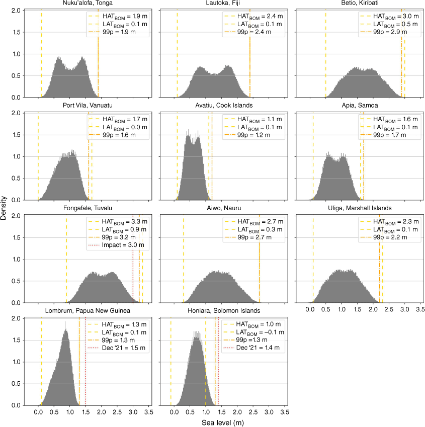
To allow analysis at other locations, we approximate coastal flood thresholds using percentile-based thresholds for each included PSLGM location using the 99th percentile of daily maximum sea levels. The 99th percentile is calculated using all days on record at each site and will, by definition, result in three to four exceedances on average per calendar year. This level is chosen as it corresponds to flooding that happens during king tides or severe weather events; however, it may misestimate flood risk on average if floods typically occur more or less frequently than 3–4 times per year. For instance, for Fongafale, Tuvalu, we determine an impact threshold of 3.0 m, which is 30 cm lower than the percentile threshold, 3.3 m (Fig. 2). Hence, if we used the percentile threshold to assess coastal flood risk in Tuvalu, we would conclude that flooding is much rarer than it is based on documented impacts. However, the percentile threshold does correspond to the sea level associated with a moderate-major flood event that occurred in February 2022 and can therefore provide information about the re-occurrence frequency of equivalent exceedances. Conversely, at sites where tide-driven coastal flooding (not due to inclement weather) is currently rare, such as Avatiu in the Cook Islands, the percentile threshold will be higher than the (yet-to-be-defined) impact threshold and overestimate the current flood risk.
The sea level distributions for the sites show a range of different shape characteristics (Fig. 2). For instance, the site in Tonga has a bimodal distribution in observed sea level whereas Vanuatu is unimodal, and Tuvalu has a large tidal range (large spread) whereas the Cook Islands has a very narrow tidal range. These characteristics are related to local tidal dynamics and have important implications for the rate-of-change of the response of exceedances (and coastal flooding) to SLR, as this is non-linear. To demonstrate this, Supplementary Fig. S1 shows the observed daily maximum sea levels at each site. Sites with a narrow distribution of maximum sea level, such as Papua New Guinea, will see a greater proportion of daily maximum sea levels (more days) exceeding the flood threshold under increased sea level than those with greater spread, such as Nauru. In this example, a 0.5-m increase in sea level will cause the majority of daily maximums to exceed the 99th percentile threshold in Papua New Guinea, whereas 1 m of SLR would be required to have the same effect in Nauru.
These different rates of change represent how flood impacts will change through time and result from characteristics of the local tidal cycles, in particular the tidal range (see Fig. 3). Local tide cycles vary from diurnal (one high tide per day) to semi-diurnal (two high tides per day), with their particular characteristics resulting from the effects of land, such as basin structure, distance from amphidromic point(s) and the interference of associated tidal nodes. Examples of observed annual and monthly tide cycles for each site further demonstrate the impact of tidal range, with narrow spread in the predicted tide cycle leading to more exceedances as sea levels increase (Supplementary Fig. S2, S3). On the monthly scale, the effect of lower frequency (mixed to diurnal) cycles can be observed, as the proportion of predicted tides that result in exceedances under increased sea level is reduced.
The key uncertainty introduced by an inaccurate percentile-based (or other ‘extreme’) threshold relates to how soon certain flood frequencies will be observed. The differences between the percentile- and impact-based thresholds are simply differences in freeboard (defined in Table 1). The shape of the sea level distribution curve is not a function of freeboard, so differences in flood impact thresholds manifest in errors of when specific coastal flood impacts will occur, not how flood impacts will change through time. This means that projections derived using the percentile threshold can be translated to correspond to projected exceedances of another, more appropriate, threshold. For example, we use projections based on the percentile threshold to (algebraically) derive future exceedance projections for the event thresholds defined in Papua New Guinea and the Solomon Islands (Supplementary Fig. S4), associated with the December 2021 king tide. These show that the event threshold will see more exceedances sooner in Papua New Guinea and later in the Solomon Islands.
2.3. Calculating historical and projected exceedances
In this study, coastal flood events are defined as occurring when the still water level exceeds a coastal flood threshold. Hence, we can compute the number of coastal flood hours and days by identifying observations that exceed the impact- or percentile-based thresholds (as defined in Table 1). We can then equivalently consider a coastal flood day as a day that has at least one hourly threshold exceedance.
To investigate the roles of tidal and non-tidal variations in still water level on threshold exceedances we classify all coastal flood hours or coastal flood days as either ‘tide-sufficient’ or ‘surge-driven’, following the approach of Hague et al. (2022). Tide-sufficient and surge-driven exceedances are defined as in Table 1, where surge-driven events are those that required additional water level from non-tidal factors such as storm surges and sea level variability on monthly-to-interannual time scales to occur. Here we estimate the tidal component of the still water level by computing ‘annual means’ predictions for each PSLGM location. As described in Hague and Taylor (2021), this method involves computing tidal constituents based on a single year’s data and then using these constituents to estimate tides in that year. The process is repeated for every year with at least 70% data completeness in hourly observations.
We compute estimates of future coastal flooding by applying the climatology-based methods of Hague19 and Sweet et al. (2017). This involves defining a distribution of still water levels over some reference period (we use 1995–2014 here) and uniformly increasing values to correspond with specific SLR futures. Rather than considering projections for specific future economic scenarios, we compute projections of coastal flood frequencies as a function of the amount of SLR above the 1995–2014 mean. However, to facilitate comparisons to existing work, and provide context on the possible timing of SLR increments, we consider SLR scenarios from the Sixth Assessment Report (AR6) of the United Nations Intergovernmental Panel on Climate Change (IPCC) (Fox-Kemper et al. 2021) for Shared Socioeconomic Pathway (SSP) emission scenarios. The SLR futures are given for each location, relative to the 1995–2014 baseline, and are accessed from the IPCC AR6 Sea Level Projection Tool. The SSP scenarios represent the latest effort to quantify the effects of a set of most plausible set of long-term economic futures (Riahi et al. 2017). For each SSP scenario, the ‘likely’ range of SLR is between the 17th and 83rd percentiles. Here we present five scenarios of (local) SLR resulting from projections based on processes in which we have medium confidence in their future changes. These processes include changes in sterodynamic sea level, glaciers, Greenland and Antarctic ice melt, land water storage and vertical land motion. We do not explicitly consider two low-confidence scenarios, related to high impact but low-confidence potential collapse of Antarctic ice sheets, but the computation for estimates of flood threshold exceedances up to 1.5 m allows for this to be considered by the interested reader.
When considering future coastal flood frequencies, we assume that there are no changes to the factors that could affect coastal flooding, such as the mean wind climate, dynamic shoreline change (including erosion of soft shores and changes in reefs), land subsidence, mean sea level variability and storm surge activity. We further assume that no changes in infrastructure occur that would increase the flood threshold associated with damaging impacts.
3.Results
3.1. Observed changes
Fig. 1 shows the observed rate of relative SLR at each PSLGM location. Generally, SLR is quite uniform across the region, with an average 4.96 mm year–1. However, there is one high outlier of +10.3 mm year–1 in Apia, Samoa, and one low outlier of +0.5 mm year–1 in Port Vila, Vanuatu. Apia has this high rate of relative SLR due to land subsidence following the 2009 earthquake in the region (Geoscience Australia 2018; Han et al. 2019), whereas the low rate for Vanuatu because it is experiencing the greatest rate of land uplift.
Spring tides (‘Tai lasi’) or otherwise high tides in Tuvalu in recent decades have resulted in some level of flooding during the months of February and March, due to the seasonal tidal cycle and the low elevation of the atoll (mean elevation 2.3 m; Lin et al. 2014). These events are often termed ‘king tides’ (‘Tai lele’). In more recent years, however, tidal flooding has occurred once to twice a month throughout most of the year. Flooding due to these king tides or Tai lele typically lasts 1–4 h during each affected day and causes inundation of roads, houses, the airport runway and crops, groundwater and sewage contamination and salt intrusion into water storages (Table 3).
We compare the historic exceedances of the impact and percentile thresholds for Tuvalu (Fig. 4). For the, overly conservative, percentile threshold (Fig. 4b), fewer exceedances are observed as expected. This is particularly true for June–August when sea levels tend to be lower. This seasonality is reflected in exceedances of the impact threshold (Fig. 4a), where more hourly exceedances are observed during January–April than in June–July. However, in recent years this pattern is less clear, as exceedances arise in early spring for the percentile threshold and intensify in spring for the impact threshold. The stark difference between the hours exceeded for these two measures is likely to occur at other Pacific locations, indicating that obtaining impact observation for the estimation of coastal flooding should be prioritised, as such effects are only apparent at Tuvalu when using the impact threshold and not the percentile-based threshold.
Number of hours that the (a) impact and (b) 99th percentile thresholds are exceeded at Fongafale, Tuvalu for 1994–2021.

At all sites, we find more exceedances in recent years than in the earlier half of the records (Fig. 5a), agreeing with patterns evident in exceedances of the 6-month return period assessed in the Pacific Climate Change Monitor Report of the Pacific Meteorological Desk Partnership (2021). This is most pronounced in Apia, Samoa, where all years following 2010 have exceedances of the percentile threshold and 2006 is the only preceding year with exceedances. This is a direct result of the 2009 earthquake, which caused ongoing land subsidence, exacerbating relative SLR and meaning Apia cannot be compared directly to other sites and the results are not indicative of the effects of SLR more generally. The highest annual exceedance values are for Lombrum, Papua New Guinea in 2021, Aiwo, Nauru in 2014 and Apia, Samoa in 2019 and 2021, where the percentile threshold was exceeded for 70–80 days of the year. There are no exceedances at any site in 2004, possibly associated with the recent 2002–03 El Niño event.
Exceedances of the 99th percentile of daily maximum sea levels at each PSLGM location. (a) Number of days exceeded in each year, (b) average number of hours exceeded in each month annually and (c) average number of exceedances in each hour, local time, annually.

The historical seasonality of exceedances at each site is shown in Fig. 5b. In general, January, February and March show the greatest frequency of exceedances at each site, whereas June, July and August have the lowest. In Honiara, Solomon Islands, and Apia, Samoa, this pattern is slightly shifted, with March and April showing the highest exceedance counts with moderate exceedances persisting into May. Uliga, Marshall Islands, and Betio, Kiribati, have a peak in September that is not observed in other sites.
The time of day of the historical exceedances exhibits a strong diurnal pattern at each PSLGM location (Fig. 5c). Each site has two periods in the diurnal cycle where exceedances may arise, the later of which has a greater peak. The clearly defined timing results from the 28-day tidal cycle, as spring tides re-occur at the same time of day. For sites excluding Lombrum, Papua New Guinea, Avatiu, Cook Islands and Nuku’alofa, Tonga, the first peak is in the early morning between 0400 and 0700 hours and the second in the late afternoon between 1600 and 1800 hours. In Lombrum, the afternoon peak occurs earlier, at 1400 hours. In Nuku’alofa, both the morning and afternoon peaks occur later than at other sites, at 0800 and 2100 hours. In Avatiu, the shift is most pronounced; the two peaks arise at 1100 and 2300 hours and are similar in magnitude. Further, exceedances are not isolated to the proximity of the two peaks, 22 of the 24 h of the day have exceedances whereas for other locations this number is closer to 8–10. This difference may relate to the different tidal phase observed in Avatiu (Woodworth 2019; Supplementary Fig. S2, S3).
A key aim of this research was to understand the changes in tide-sufficient coastal flooding (defined in Table 4). Over the historic period, 19–63% of exceedances at different sites were tide sufficient. The highest proportions of tide-sufficient exceedances occurred in Fiji, Kiribati, Samoa, Tuvalu and the Marshall Islands (43–63%), many of which are known to experience tide-sufficient (or ‘sunny-day’) flooding at a frequency of concern. The lowest proportion of tide-sufficient coastal flooding occurred in the Cook Islands (19%). This aligns with expectations, as currently flooding only arises in Avatiu under stormy conditions and is often associated with heavy rainfall (Cook Islands Meteorological Service).
| PSLGM location | Percentage tide-sufficient (%) | |
|---|---|---|
| Nuku’Alofa, Tonga | 25 | |
| Lautoka, Fiji | 48 | |
| Betio, Kiribati | 45 | |
| Port Vila, Vanuatu | 25 | |
| Avatiu, Cook Islands | 19 | |
| Apia, Samoa | 63 | |
| Fongafale, Tuvalu | 56 | |
| Aiwo, Nauru | 34 | |
| Uliga, Marshall Islands | 43 | |
| Lombrum, Papua New Guinea | 26 | |
| Honiara, Solomon Islands | 37 |
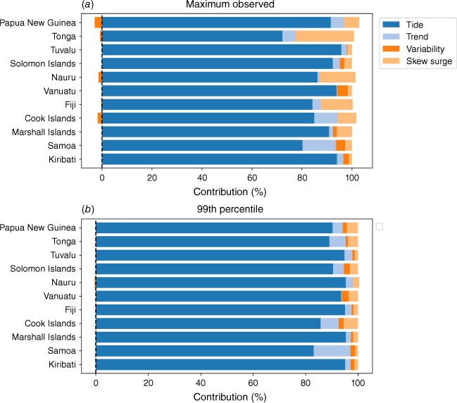
More generally, as the factors that influence sea levels vary on a range of spatial and temporal scales, their relative contribution to exceedances varies at different threshold levels as well. For example, Fig. 6 shows that the relative contribution of the skew surge (which captures the influence of storm surge) in Tonga is greater for the maximum observed sea level than it is for the 99th percentile level. Although tides are the dominant contributor to water levels when flood thresholds are exceeded, long term trends, variability and the skew surge are also important factors, particularly for the more extreme threshold (maximum observed sea level). Despite these factors representing a smaller proportion of overall water levels, they can be the difference between whether or not flooding occurs. This is shown in Table 4, where most locations experience less than 50% of floods due solely to tidal processes. This result further highlights the importance of impact-based thresholds, as these will allow, not for only projections of relevant flood frequency risks, but also for diagnosis of the key contributing processes to those risks.
Contribution of tide, trend in mean annual observed sea level, variability (mean annual difference from trend) and skew surge to (a) the maximum observed sea level and (b) the 99th percentile of daily maximum sea levels at each study location. A 0% contribution corresponds to the LAT (defined in Table 1) level, whereas 100% contribution corresponds to the specific threshold level.
3.2. Future changes
By the time local sea levels have risen 1.15 m, all 11 PSLGM project locations will see daily exceedances of the present day 99th percentile of daily maximum sea levels (Fig. 7). For many sites, however, this point is reached at an earlier increment of SLR. For example, in Avatiu, Cook Islands, daily exceedances are observed at ~0.5 m of SLR, a level projected to be reached before 2100 under mid-range emission scenarios, and earlier for high emission scenarios. Avatiu also has one of the greatest numbers of projected annual exceedances in 2050, along with Lombrum, Papua New Guinea, both with 75–175 days in 2050 when considering median SSP scenarios.
Projected annual exceedances of the present day 99th percentile of daily maximum sea levels. The projected timing of sea level rise increments under five SSPs is shown in dashed lines.

The results for these two sites are related to higher rate of change in exceedances compared to other locations, which results from the smaller tidal range. In general, the rate of change of exceedance rises to an inflection point between 100 and 250 annual exceedance days, after which the rise slows with the approach to daily exceedance.
Betio, Kiribati, and Aiwo, Nauru, have approximately linear changes in exceedance frequencies, a different shape to that observed at other sites. Both sites show mixed semidiurnal tidal cycles, high tidal range and annual tidal cycles with oscillating high and moderate peak levels. These characteristics act to dampen the rate of change of exceedance frequency for increasing SLR (Section 2.2.2). To a lesser degree, similar tidal dynamics and projected exceedance frequencies are observed in Uliga, Marshall Islands, and Fongafale, Tuvalu, supporting this connection.
Although uncertainty in the relationship between increasing relative mean sea level and the frequency of threshold exceedances is limited, large uncertainties exist in the projected timing of given SLR increments. These uncertainties pertain to two key classes, uncertainty in future human economic activity and the related greenhouse gas emissions and uncertainty in the response of mean sea levels to global emissions. The associated uncertainty range in the SLR response for each scenario increases with time, meaning that the local SLR projections for each location show more uncertainty for 2100 than 2050. Although the uncertainty ranges are not shown in Fig. 7, this effect can be observed in the reduced spread of median SSP results for 2050 sea levels compared to 2100. This means we have greater confidence in the magnitude of exceedance frequency, and indicated coastal flood risk, under a given SSP scenario in 2050 than in 2100. An example of the uncertainty within one SSP is given in Fig. 8, in which the 17th and 83rd percentiles (the ‘likely’ range) are shaded, revealing that according to SSP5–8.5 it is ‘likely’ that 2050 may see at least 100 or as many as 200 days of coastal flooding annually in Tuvalu, a wide spread about the median.
Effect of changing the flood threshold in Fongafale, Tuvalu, and Avatiu, Cook Islands. (a) Projections of each threshold and (b) of the HAT/February ’22 threshold, with the start points of the lower three thresholds indicated on the curve. (c) Projections of each threshold in the Cook Islands and (d) projections of the maximum observed sea level, with the start points of lower thresholds indicated. The 17th and 83rd percentiles (the ‘likely’ range) of SSP5–8.5 are shaded about the median (dashed line).

4.Discussion
Sea levels are rising across all sites assessed in the PSLGM network, with an associated increase in the frequency at which percentile- and impact-based threshold levels are being exceeded. This change has both increased the number and duration of exceedances during the months when water levels tend to be higher, and now also means that high sea levels are increasingly seen throughout the year. This has implications for coastal flood risk management. For example, impacts differ under the annual projection of 152 days of flooding in 2050 (given by the impact threshold at Fongafale, Tuvalu; Fig. 8a) if the flood days are distributed evenly throughout the year (exceeded every 2–4 days) or if they are clustered in January–March (more than every 2–4 days, for instance, every day) and less frequent at other times. Such clustering is related to both the spring–neap cycle as well as multi-annual nodal cycles (Thompson et al. 2021).
We also show that the time of day at which exceedances historically occurred was limited to two peaks within the day, one morning and one afternoon, with the exact timing and spread of the peaks varying between sites. This is an important result for coastal management, given that minor flooding tends to be most damaging when it disrupts movement or economic activity (e.g. Hino et al. 2019; Kasmalkar et al. 2020). Hence, if daily high tides at the time of spring tide occur overnight, their impacts may not be as severe as if they occurred during business hours. The predictability of the tidal cycle is also useful to understand how and when tides are most likely to combine with other factors, such as tropical cyclones which deliver heavy rainfall and storms, to cause extreme flooding.
In both the historical impact and percentile threshold exceedances in Tuvalu (Fig. 4), the influence of ENSO can be observed. The ENSO describes the oscillation between El Niño and La Niña conditions in the Pacific Ocean, which respectively refer to warming and cooling of the western Pacific Ocean with associated changes in sea level due to thermal expansion. For example, the lower sea levels associated with the strong El Niño events of 1997–98 (Widlansky et al. 2014) resulted in no exceedances of the impact threshold at Fongafale in January, February and March, when coastal floods are typically the most frequent (Fig. 4). A similar effect was observed in January and February 2016, which saw a strong El Niño event in the first half of the year (Santoso et al. 2017).
In all locations, the rapid increase in projected exceedance frequency with respect to relative SLR highlights how future flooding will increasingly occur due to tides alone, assuming no changes in infrastructure. Meaning that future flooding will become increasingly predictable. This change has been observed in recent years in Tuvalu, where previously rare flood events, driven by spring tides combined with other, less predictable, factors, now occur due to the regular spring tides alone.
In this study, we have not explicitly considered the roles that waves, wind, storms and tsunamis play in the coastal setting. Each of these phenomena can (collectively or individually) cause damaging coastal flood events across the Pacific. For example, Smith and Juria (2019) analysed historical inundation events in Majuro, Marshall Islands, using both PSLGM tide gauge data and wave information. Their results showed that half of the 17 assessed inundation events saw significant contributions from north-easterly swell and waves, and that spring tides during La Niña years could cause inundation, regardless of contributions from swell.
Heavy rainfall and poor drainage can also result in significant coastal flood events. In the Cook Islands, historical inundation events are largely associated with extreme or prolonged rainfall (e.g. Radio New Zealand 2020; Etches 2021). In these circumstances, coastal flooding arises because poor drainage allows water to stagnate in the coastal zone, the effects of which can be compounded by the influences of tides and wave energy. Another cause of extreme coastal inundation is tsunami events. The tidal height at the time that a tsunami reaches the shore is a key factor in the potential for these events to cause flooding. The recent eruption of submarine volcano Hunga Tonga–Hunga Haʻapai resulted in a tsunami event on 15 January 2022. The event coincided with high tides in Tonga, which contributed to the sea level extremes observed at the time.
4.1. Importance of knowing the impact threshold for projections
Defining an impact threshold that relates to particular impacts of concern (e.g. flooding of main streets and infrastructure) is crucial for understanding present and future risk of said impacts reoccurring due to coastal flooding. This need is compounded by the sensitivity of future exceedance frequency to different thresholds. To demonstrate this, projections of the future exceedances of the impact-, event- and percentile-based thresholds in Tuvalu are given in Fig. 8a. The difference between the impact- and event-based thresholds is 30 cm. However, the number of flood days under the SSP5–8.5 median projection shows that this 30-cm difference in water level causes a sixfold difference in flood exceedances – with the February 2022 level expected 25 days per year and the impact level of 3.0 m expected 152 days per year on average. Similarly, if we had used the 99th percentile value (3.2 m), without understanding that this may not be the true flood threshold, we would have underestimated flood risk by more than 100 days per year under this SSP scenario (Fig. 8a).
The flood risk for other locations may also be being significantly underestimated by the 99th percentile. This is likely for locations where high tides have been known to cause flooding in the past, such as Kiribati and the Marshall Islands. However, without sufficient impact information for these sites, the degree to which the results presented in Fig. 7 underestimate the true flood risk cannot be determined.
For Tuvalu, we can represent the differences in thresholds as different starting points on the same trajectory (Fig. 8b). For example, it takes 1.15 m SLR for daily flooding at the severity of the February 2022 flood (without any flood risk mitigation to lower the threshold), but 0.85 m for daily flooding at the lowest observed severity. That the difference between these values (0.30 m) is the same as the vertical distance between thresholds (3.30 and 3.00 m) is not a coincidence – it arises from the definition of freeboard and the convention that heights of high tides rise under SLR (Sweet and Park 2014).
More generally, we found that locations with small tidal ranges were more likely to experience more rapid acceleration in the frequency of coastal flood events, compared to locations with higher tidal ranges (see Section 2.2.2 and Fig. 7). How soon such rapid accelerations are to be expected is determined by freeboard, the relative height of flood thresholds compared to high tide marks. By comparing projections for Tuvalu and the Cook Islands (Fig. 8), we show how these two controlling factors modify future flood risk. Tuvalu has a larger tidal range than the Cook Islands (Table 2) but has a more positive freeboard. All recently observed flood events in the Cook Islands have occurred as compound rainfall–coastal floods. This suggests that coastal flooding due to high still water levels occur less frequently than the 3–4 times per year implied by the 99th percentile of daily maximum still water levels.
We know that because the Cook Islands have a small tidal range, flood threshold exceedances will accelerate quickly once tidal flooding emerges (Fig. 8c). For example, 24 cm of SLR will result in an increase from 0 days per year of coastal flooding into 182 days per year for any given flood threshold. When this occurs depends on where the threshold sits relative to the range of historical water levels, designated by the freeboard. If the threshold of concern is the present-day 99th daily maximum still water level, then it could be before 2050 under SSP5–8.5 median. However, if the threshold is 34 cm above the 99th percentile, for example, then such increases would be delayed until 2100. That is, the percentile threshold would lead to the incorrect conclusion the coastal flooding will likely be more frequent in the Cook Islands in coming years than in Tuvalu. This perspective on freeboard designating the current position on a coastal flood trajectory emphasises why defining impact-based thresholds is imperative, especially for locations with small tidal ranges like the Cook Islands.
A key limitation of this research is the unavailability of impact thresholds for many PSLGM locations, meaning we cannot directly quantify the current flooding risk. Efforts to collate past and future impact reports through citizen and scientific monitoring programs are recommended as a priority for assessing current and future flood risk.
5.Conclusion
We conducted a broad assessment of historical and projected coastal inundation frequency in 11 Pacific small-island nations. This research was made possible by the availability of long-term (greater than 20 years) tide gauge data in the study locations, provided by the PSLGM Project, which had recently become sufficient in duration to detect emerging anthropogenic-driven trends. Further, direct engagement with in-country meteorological services has facilitated the impact-oriented approach to assessing the observed and future changes to coastal flooding risk in the Pacific.
Through the case study of Tuvalu and the Cook Islands, we demonstrated how under- or over-estimating the impact-based threshold by using an extreme threshold (the 99th percentile of daily maximum sea levels) would lead to incorrect assumptions about the relative risk of coastal flooding at each location into the future (i.e. impact information is needed to assess vulnerability to damaging coastal floods). This need is reiterated using the example of Tuvalu, as impact thresholds require centimetre-accuracy because differences in threshold levels of 20 cm can result in misestimations of coastal flood risk of more than 100 days per year. Further, although we know that tidal range is a large factor in determining the potential for rapid increases in coastal flood frequencies, the timing of these increases can only be known once a flood threshold of interest is determined.
Unfortunately, a sufficient number of historical flood event records could not be collected for all sites, either due to a lack of accessible reports or infrequent tidal flooding events. For this reason, the bulk of analyses were conducted using the 99th percentile threshold alone. Using this, we show that observed exceedances of the percentile threshold have increased in frequency and changed in seasonality across the Pacific. Although exceedances still occur mostly in summer, winter and spring, exceedances have arisen in the recent decade, when previously these were rare or did not occur. Exceedances of this extreme threshold also saw a clear diurnal pattern whereby exceedances occurred in two distinct periods of the day, typically the early morning and afternoon. This is a result of the 28-day tidal cycle, with the highest high tides occurring at the same time of day in each period.
Using the 99th percentile of daily maximum still water level as an estimate of this flood level, we show that extreme sea level events or floods that currently occur 3–4 times per year will be daily occurrences at most locations in the Pacific by the end of the century. Furthermore, such flooding will occur simply because of the tides, although persistent sea level anomalies (see Fig. 6) or tropical cyclones will add to any flood impacts on a particular day. Thus, flooding will become increasingly predictable into the future, and able to be forecasted using tide tables.
Data availability
Tide gauge data are available to the public from the Australian Bureau of Meteorology at http://www.bom.gov.au/oceanography/projects/spslcmp/data/index.shtml.
Acknowledgements
The authors acknowledge two internal reviewers and two anonymous reviewers for their expertise and time, whose comments have improved this manuscript.
References
Buchanan MK, Oppenheimer M, Kopp RE (2017) Amplification of flood frequencies with local sea level rise and emerging flood regimes. Environmental Research Letters 12, 064009.
| Crossref | Google Scholar |
Dowdy A, Kuleshov Y (2012) An analysis of tropical cyclone occurrence in the Southern Hemisphere derived from a new satellite-era data set. International Journal of Remote Sensing 33, 7382-7397.
| Crossref | Google Scholar |
Etches M (2021) Heavy rain causes flash floods. In Cook Islands News, 24 February 2021. Available at https://www.cookislandsnews.com/national/weather/heavy-rain-causes-flash-floods/ [Verified 14 January 2022]
Farbotko C (2010) Wishful sinking: disappearing islands, climate refugees and cosmopolitan experimentation. Asia Pacific Viewpoint 51, 47-60.
| Crossref | Google Scholar |
Fennell J (2021) Expert warns La Niña likely to see coastal flooding in Pacific continue for months. In ABC Pacific, 9 December 2021. [Broadcast] Available at https://www.abc.net.au/pacific/programs/pacificbeat/la-nina-coastal-flooding-continue-for-months-pacific/13669316
Fohringer J, Dransch D, Kreibich H, Schröter K (2015) Social media as an information source for rapid flood inundation mapping. Natural Hazards and Earth System Sciences Discussions 3, 4231-4264.
| Crossref | Google Scholar |
Fox-Kemper B, Hewitt HT, Xiao C, Aðalgeirsdóttir G, Drijfhout SS, Edwards TL, Golledge NR, Hemer M, Kopp RE, Krinner G, Mix A, Notz D, Nowicki S, Nurhati IS, Ruiz L, Sallée J-B, Slangen ABA, Yu Y (2021) Ocean, cryosphere and sea level change. In ‘Climate Change 2021: The Physical Science Basis. Contribution of Working Group I to the Sixth Assessment Report of the Intergovernmental Panel on Climate Change’. (Eds V Masson-Delmotte, P Zhai, A Pirani, SL Connors, C Péan, S Berger, N Caud, Y Chen, L Goldfarb, MI Gomis, M Huang, K Leitzell, E Lonnoy, JBR Matthews, TK Maycock, T Waterfield, O Yelekçi, R Yu, B Zhou) pp. 1211–1362. (Cambridge University Press) 10.1017/9781009157896.011
Geoscience Australia (2018) Pacific Sea Level and Geodetic Monitoring. (Geoscience Australia) Available at https://www.ga.gov.au/scientific-topics/positioning-navigation/geodesy/pacificsealevel [Verified 14 January 2022]
Ghanbari M, Arabi M, Kao S-C, Obeysekera J, Sweet W (2021) Climate change and changes in compound coastal-riverine flooding hazard along the US coasts. Earth’s Future 9, e2021EF002055.
| Crossref | Google Scholar |
Hague BS, Taylor AJ (2021) Tide-only inundation: a metric to quantify the contribution of tides to coastal inundation under sea-level rise. Natural Hazards 107, 675-695.
| Crossref | Google Scholar |
Hague BS, Murphy BF, Jones DA, Taylor AJ (2019) Developing impact-based thresholds for coastal inundation from tide gauge observations. Journal of Southern Hemisphere Earth Systems Science 69, 252-272.
| Crossref | Google Scholar |
Hague BS, McGregor S, Murphy BF, Reef R, Jones DA (2020) Sea level rise driving increasingly predictable coastal inundation in Sydney, Australia. Earth’s Future 8, e2020EF001607.
| Crossref | Google Scholar |
Hague BS, Jones DA, Jakob D, McGregor S, Reef R (2022) Australian coastal flooding trends and forcing factors. Earth’s Future 10, e2021EF002483.
| Crossref | Google Scholar |
Haigh ID, Pickering MD, Green JAM, Arbic BK, Arns A, Dangendorf S, Hill DF, Horsburgh K, Howard T, Idier D, Jay DA, Jänicke L, Lee SB, Müller M, Schindelegger M, Talke SA, Wilmes S-B, Woodworth PL (2020) The tides they are a-changin’: a comprehensive review of past and future nonastronomical changes in tides, their driving mechanisms, and future implications. Reviews of Geophysics 58, e2018RG000636.
| Crossref | Google Scholar |
Han S-C, Sauber J, Pollitz F, Ray R (2019) Sea level rise in the Samoan Islands escalated by viscoelastic relaxation after the 2009 Samoa–Tonga Earthquake. Journal of Geophysical Research: Solid Earth 124, 4142-4156.
| Crossref | Google Scholar |
Harley MD, Kinsela MA, Sánchez-García E, Vos K (2019) Shoreline change mapping using crowd-sourced smartphone images. Coastal Engineering 150, 175-189.
| Crossref | Google Scholar |
Hino M, Belanger ST, Field CB, Davies AR, Mach KJ (2019) High-tide flooding disrupts local economic activity. Science Advances 5(2), eaau2736.
| Crossref | Google Scholar |
Hoeke RK, Damlamian H, Aucan J, Wandres M (2021) Severe flooding in the atoll nations of Tuvalu and Kiribati triggered by a distant Tropical Cyclone Pam. Frontiers in Marine Science 7, 539646.
| Crossref | Google Scholar |
Karegar MA, Dixon TH, Malservisi R, Kusche J, Engelhart SE (2017) Nuisance flooding and relative sea-level rise: the importance of present-day land motion. Scientific Reports 7, 11197.
| Crossref | Google Scholar |
Kasmalkar IG, Serafin KA, Miao Y, Avery Bick I, Ortolano L, Ouyang D, Suckale J (2020) When floods hit the road: resilience to flood-related traffic disruption in the San Francisco Bay area and beyond. Science Advances 6(32), eaba2423.
| Crossref | Google Scholar |
Lin C-C, Ho C-R, Cheng Y-H (2014) Interpreting and analyzing king tide in Tuvalu. Natural Hazards and Earth System Sciences 14, 209-217.
| Crossref | Google Scholar |
McInnes KL, White CJ, Haigh ID, Hemer MA, Hoeke RK, Holbrook NJ, Kiem AS, Oliver ECJ, Ranasinghe R, Walsh KJE, Westra S, Cox R (2016) Natural hazards in Australia: sea level and coastal extremes. Climatic Change 139, 69-83.
| Crossref | Google Scholar |
Moftakhari HR, AghaKouchak A, Sanders BF, Matthew RA (2017) Cumulative hazard: the case of nuisance flooding. Earth’s Future 5, 214-223.
| Crossref | Google Scholar |
Moftakhari HR, AghaKouchak A, Sanders BF, Allaire M, Matthew RA (2018) What Is nuisance flooding? Defining and monitoring an emerging challenge. Water Resources Research 54, 4218-4227.
| Crossref | Google Scholar |
Moore FC, Obradovich N (2020) Using remarkability to define coastal flooding thresholds. Nature Communications 11, 530.
| Crossref | Google Scholar |
Needham HF, Keim BD, Sathiaraj D (2015) A review of tropical cyclone-generated storm surges: global data sources, observations, and impacts. Reviews of Geophysics 53, 545-591.
| Crossref | Google Scholar |
Nicholls RJ, Lincke D, Hinkel J, Brown S, Vafeidis AT, Meyssignac B, Hanson SE, Merkens J-L, Fang J (2021) A global analysis of subsidence, relative sea-level change and coastal flood exposure. Nature Climate Change 11, 338-342.
| Crossref | Google Scholar |
Oppenheimer M, Glavovic BC, Hinkel J, van de Wal R, Magnan AK,Abd-Elgawad A, Cai R, Cifuentes-Jara M, DeConto RM, Ghosh T, Hay J, Isla F, MarzeionB, Meyssignac B, Sebesvari Z (2019) Sea level rise and implications forlow-lying islands, coasts and communities. In ‘IPCC Special Report on the Oceanand Cryosphere in a Changing Climate’. (Eds H-O Pörtner, DC Roberts, V Masson-Delmotte, P Zhai, M Tignor, E Poloczanska, K Mintenbeck, A Alegría, M Nicolai, A Okem, J Petzold, B Rama, NM Weyer) pp. 321–445. (Cambridge University Press) 10.1017/9781009157964.006
Pacific Meteorological Desk Partnership (2021) Pacific Islands Climate Change Monitor: 2021. Available at https://www.pacificmet.net/pacific-climate-change-monitor-report-2021
Radio New Zealand (2020) Floods strike Cook Islands’ Rarotonga. In Radio New Zealand, 8 August 2020. Available at https://www.rnz.co.nz/international/pacific-news/423069/floods-strike-cook-islands-rarotonga [Verified 14 January 2022]
Rasmussen DJ, Bittermann K, Buchanan MK, Kulp S, Strauss BH, Kopp RE, Oppenheimer M (2018) Extreme sea level implications of 1.5 °C, 2.0 °C, and 2.5 °C temperature stabilization targets in the 21st and 22nd centuries. Environmental Research Letters 13, 034040.
| Crossref | Google Scholar |
Riahi K, van Vuuren DP, Kriegler E, Edmonds J, O’Neill BC, Fujimori S, Bauer N, Calvin K, Dellink R, Fricko O, Lutz W, Popp A, Cuaresma JC, Samir KC, Leimbach M, Jiang L, Kram T, Rao S, Emmerling J, Ebi K, Hasegawa T, Havlik P, Humpenöder F, da Silva LA, Smith S, Stehfest E, Bosetti V, Eom J, Gernaat D, Masui T, Rogelj J, Strefler J, Drouet L, Krey V, Luderer G, Harmsen M, Takahashi K, Baumstark L, Doelman JC, Kainuma M, Klimont Z, Marangoni G, Lotze-Campen H, Obersteiner M, Tabeau A, Tavoni M (2017) The shared socioeconomic pathways and their energy, land use, and greenhouse gas emissions implications: an overview. Global Environmental Change 42, 153-168.
| Crossref | Google Scholar |
Rueda A, Vitousek S, Camus P, Tomás A, Espejo A, Losada IJ, Barnard PL, Erikson LH, Ruggiero P, Reguero BG, Mendez FJ (2017) A global classification of coastal flood hazard climates associated with large-scale oceanographic forcing. Scientific Reports 7, 5038.
| Crossref | Google Scholar |
Santoso A, Mcphaden MJ, Cai W (2017) The defining characteristics of ENSO extremes and the strong 2015/2016 El Niño. Reviews of Geophysics 55, 1079-1129.
| Crossref | Google Scholar |
Slangen ABA, Church JA, Agosta C, Fettweis X, Marzeion B, Richter K (2016) Anthropogenic forcing dominates global mean sea-level rise since 1970. Nature Climate Change 6, 701-705.
| Crossref | Google Scholar |
Smith G, Juria N (2019) Diagnosis of historical inundation events in the Marshall Islands to assist early warning systems. Natural Hazards 99, 189-216.
| Crossref | Google Scholar |
Sweet WV, Park J (2014) From the extreme to the mean: acceleration and tipping points of coastal inundation from sea level rise. Earth’s Future 2(12), 579-600.
| Crossref | Google Scholar |
Sweet WV, Kopp RE, Weaver CP, Obeysekera J, Horton RM, Thieler ER, Zervas C (2017) Global and regional sea level rise scenarios for the United States. NOAA Technical Report NOS CO‐OPS 083 NOAA/NOS, NOS. (NOOA Center for Operational Oceanographic Products and Services: Silver Spring, MD, USA) 10.7289/v5/tr-nos-coops-083
Sweet WV, Genz AS, Obeysekera J, Marra JJ (2020) A regional frequency analysis of tide gauges to assess Pacific coast flood risk. Frontiers in Marine Science 7, 581769.
| Crossref | Google Scholar |
Sweet WV, Hamlington BD, Kopp RE, Weaver CP, Barnard PL, Bekaert D, Brooks W, Craghan M, Dusek G, Frederikse T, Garner G, Genz AS, Krasting JP, Larour E, Marcy D, Marra JJ, Obeysekera J, Osler M, Pendleton M, Roman D, Schmied L, Veatch W, White KD, Zuzak C (2022) Global and regional sea level rise scenarios for the United States: updated mean projections and extreme water level probabilities along US coastlines. NOAA Technical Report NOS 01. (National Oceanic and Atmospheric Administration, National Ocean Service: Silver Spring, MD, USA) Available at https://aambpublicoceanservice.blob.core.windows.net/oceanserviceprod/hazards/sealevelrise/noaa-nos-techrpt01-global-regional-SLR-scenarios-US.pdf
Thompson PR, Widlansky MJ, Hamlington BD, Merrifield MA, Marra JJ, Mitchum GT, Sweet W (2021) Rapid increases and extreme months in projections of United States high-tide flooding. Nature Climate Change 11, 584-590.
| Crossref | Google Scholar |
Vitousek S, Barnard PL, Fletcher CH, Frazer N, Erikson L, Storlazzi CD (2017) Doubling of coastal flooding frequency within decades due to sea-level rise. Scientific Reports 7, 1399.
| Crossref | Google Scholar |
Wahl T, Haigh ID, Nicholls RJ, Arns A, Dangendorf S, Hinkel J, Slangen ABA (2017) Understanding extreme sea levels for broad-scale coastal impact and adaptation analysis. Nature Communications 8, 16075.
| Crossref | Google Scholar |
Wandres M, Aucan J, Espejo A, Jackson N, de Ramon N’Yeurt A, Damlamian H (2020) Distant-source swells cause coastal inundation on Fiji’s coral coast. Frontiers in Marine Science 7, 546.
| Crossref | Google Scholar |
Widlansky MJ, Timmermann A, McGregor S, Stuecker MF, Cai W (2014) An interhemispheric tropical sea level seesaw due to El Niño Taimasa. Journal of Climate 27, 1070-1081.
| Crossref | Google Scholar |
Widlansky MJ, Long X, Schloesser F (2020) Increase in sea level variability with ocean warming associated with the nonlinear thermal expansion of seawater. Communications Earth & Environment 1(1), 9.
| Crossref | Google Scholar |
Woodworth PL (2019) The global distribution of the M1 ocean tide. Ocean Sci 15, 431-442.
| Crossref | Google Scholar |
Woodworth PL, Menéndez M, Roland Gehrels W (2011) Evidence for century-timescale acceleration in mean sea levels and for recent changes in extreme sea levels. Surveys in Geophysics 32, 603-618.
| Crossref | Google Scholar |
World Meteorological Organization (2017) WMO guidelines on the calculation of climate normals. WMO-No. 1203. (WMO: Geneva, Switzerland) Available at https://library.wmo.int/doc_num.php?explnum_id=4166