
Seasonal climate summary for the southern hemisphere (winter 2017): exceptionally warm days for Australia
David J. Martin A B and Skie Tobin AA Bureau of Meteorology, GPO Box 1289, Melbourne, Vic. 3001, Australia.
B Corresponding author. Email: david.martin2@bom.gov.au
Journal of Southern Hemisphere Earth Systems Science 69(1) 331-350 https://doi.org/10.1071/ES19012
Submitted: 6 August 2019 Accepted: 20 August 2019 Published: 11 June 2020
Journal Compilation © BoM 2019 Open Access CC BY-NC-ND
Abstract
This is a summary of the southern hemisphere atmospheric circulation patterns and meteorological indices for austral winter 2017; an account of seasonal rainfall and temperature for the Australian region is also provided. The El Niño–Southern Oscillation was neutral during winter 2017, as was the Indian Ocean Dipole. A positive Southern Annular Mode influenced the climates of southern hemisphere countries at times during winter. Despite the lack of large-scale ocean influences, mean temperatures for the season were very much above average across large areas of Australia, New Zealand, southern Africa and South America. Precipitation during the season was below average across much of Australia, South Africa and western areas of Chile and Argentina, but above average in some southern and eastern areas of South America.
1 Introduction
This summary reviews the southern hemisphere and equatorial climate patterns for winter 2017, with particular attention given to the Australasian and equatorial regions of the Pacific and Indian Ocean basins. The main sources of information for this report are analyses prepared by the Australian Bureau of Meteorology, the United States National Oceanic and Atmospheric Administration (NOAA) and the Global Precipitation Climatology Centre.
Unless otherwise stated, anomalies are calculated with respect to the period from 1961 to 1990, and percentile-based analyses for the period from the start of the relevant data set to 2017.
2 Pacific and Indian Ocean basin climate indices
2.1 Southern Oscillation Index
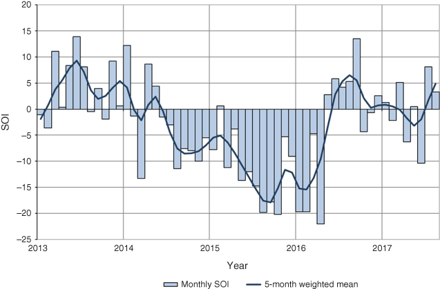
The Troup Southern Oscillation Index1 (SOI) is based on the mean sea level pressure (MSLP) difference between Tahiti and Darwin (see Fig. 1 for the SOI and other climate indices’ locations). Sustained negative values below −7 generally indicate El Niño, whereas sustained positive values above +7 generally indicate La Niña. The SOI for the period January 2013 to August 2017 is shown in Fig. 2, together with a 5-month weighted moving average.

|
|
From June 2014 to April 2016, SOI values were predominantly El Niño-like, the main exception being a weakly positive monthly value of +0.6 for February 2015. That positive value in late summer 2014–15 represents the short break between the near or marginal El Niño event in 2014 and the much stronger event in 2015 (though volatility in the SOI is common at that time of the year). El Niño, which had commenced in 2015, transitioned to neutral conditions during autumn 2016 (Chandler 2016; Martin 2016; Pepler 2016), with El Niño–Southern Oscillation (ENSO) neutral continuing since that time.
For winter 2017, the SOI decreased sharply in June to a value of −10.4 before increasing to +8.1 in July and +3.3 in August, giving a seasonal average of +0.3. Winter MSLP values for Darwin were 0.4 hPa above average at 1013.2 hPa and for Tahiti were 0.6 hPa above average at 1014.7 hPa.
2.2 Composite monthly El Niño–Southern Oscillation index (5VAR)
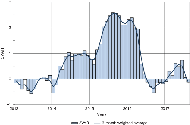
The 5VAR2 composite monthly ENSO index is calculated as the standardised amplitude of the first principal component of Darwin and Tahiti MSLP and NINO3, NINO3.4 and NINO4 sea surface temperatures3 (SSTs). Significant positive values of the 5VAR (in excess of one standard deviation) are typically associated with El Niño, whereas significant negative values are indicative of La Niña. Monthly 5VAR values for the period January 2013 to August 2017 are shown in Fig. 3.
|
Values of 5VAR generally remained just below +1 standard deviations for much of 2014. They dipped during summer 2014–15 but then increased steadily throughout autumn 2015 to above +2 standard deviations in May. By spring 2015, values were consistent with a strong and mature El Niño event (Martin 2016).
In May 2016, 5VAR values rapidly fell below +1 standard deviation, and since then, magnitudes have remained less than one standard deviation. For winter 2017, monthly values were +0.7, +0.1 and −0.1 for June, July and August respectively.
The NINO3.4 index, which measures SSTs in the central Pacific Ocean between 5°N–5°S and 120–170°W, is used by the Australian Bureau of Meteorology to monitor ENSO; NINO3.4 is closely related to the Australian climate (Wang and Hendon 2007). The mean NINO3.4 index for winter 2017 was 0.4°C above average, within the neutral range and well below the threshold of +0.8°C that typically indicates an El Niño event.
2.3 Indian Ocean Dipole
The Indian Ocean Dipole (IOD) (Saji et al. 1999) describes the pattern of SSTs across the equatorial Indian Ocean. A negative phase of the IOD is characterised by warmer than average water in the tropical eastern Indian Ocean (off the coast of Sumatra) and cooler than average water in the tropical western Indian Ocean near the Horn of Africa (see Fig. 1). It is typically associated with increased rainfall in the eastern Indian Ocean and across southern Australia during winter–spring (Risbey et al. 2009). The opposite is true for a positive IOD.
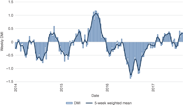
The IOD is said to be in a positive phase when values of the Dipole Mode Index (DMI) (see map in Fig. 1) are greater than +0.4°C for at least 2 months, neutral when the DMI is sustained between −0.4 and +0.4°C and negative when DMI values are less than −0.4°C.
A negative IOD pattern established in winter 2016 and continued into spring. The DMI then increased during spring and summer to neutral values and remained neutral through winter 2017 (see Fig. 4).
|
SSTs in the western tropical Indian Ocean were warmer than average during winter (Fig. 5). Although SSTs were cooler than average in parts of the eastern Indian Ocean more broadly, SSTs in the eastern node of the DMI were close to average, with the difference between the east and west nodes insufficient for a positive IOD event.

|
However, despite being below the threshold for a positive IOD, the cooler than average waters to Australia’s northwest and warmer than average waters to the east of Africa did create a temperature gradient across the Indian Ocean that likely contributed to a drying influence on Australia.
3 Outgoing longwave radiation
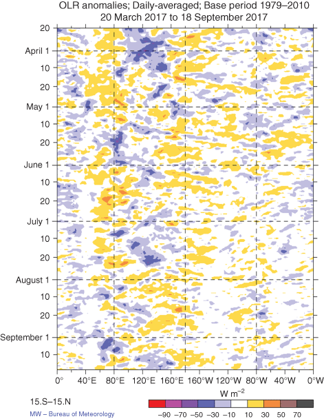
Outgoing longwave radiation (OLR) in the equatorial Pacific Ocean can be used as an indicator of enhanced or suppressed tropical convection. Increased positive OLR anomalies indicate reduced convective activity, and therefore a reduction in cloudiness and, usually, rainfall. Conversely, negative OLR anomalies indicate enhanced convection, and, therefore, increased cloudiness and chances of increased rainfall. During La Niña [El Niño], cloudiness is often reduced [increased] near the Date Line. Similarly, in the Indian Ocean, if a negative IOD is in place, cloudiness is increased over the eastern Indian Ocean but decreased over the western Indian Ocean.
The Hovmöller diagram of OLR anomalies along the equator from March to September 2017 (Fig. 6) shows the evolution of tropical convection anomalies along the equator. The NOAA’s Climate Prediction Center computes standardised monthly OLR anomalies for a region near the Date Line from 5°S to 5°N and 160°E to 160°W.4 For winter 2017, the monthly OLR anomaly values for June, July and August were +0.6, −0.4 and +0.3 respectively, indicating near-average or slightly below average convection near the Date Line. These values are consistent with an ENSO neutral phase.
|
Winter 2017 OLR anomalies across the Asia-Pacific region between 40°S and 40°N for winter 2017 are shown in Fig. 7. However, there were suspected negative biases in the OLR anomalies over subtropical land areas (estimated at around 5 W m−2) due to satellite orbit decay (Wheeler pers. comm.). So, also shown (in Fig. 8) is a map of the seasonal precipitation anomalies as calculated from NOAA’s Climate Anomaly Monitoring System-OLR Precipitation Index (CAMS_OPI) analysis for the Pacific region.

|

|
Precipitation during the season was below average across much of Australia, South Africa and western areas of Chile and Argentina, but above average across Indonesia and in some eastern areas of both Argentina and Uruguay.
Maps of the seasonal OLR totals and anomalies for the globe are shown in Fig. 9. Keeping in mind the uncertainty in the OLR anomalies in the Australian region, the seasonal OLR anomalies were generally small in magnitude across most of the southern hemisphere. There were negative OLR anomalies over much of the Maritime Continent though, which was well reflected in the wetter than average season for much of Indonesia.

|
4 Oceanic patterns
4.1 Sea surface temperatures
Winter 2017 global SST anomalies, obtained from NOAA’s Optimum Interpolation analyses (Reynolds et al. 2002), are shown in Fig. 10. Negative (cool) anomalies are shown in blue shades, whereas positive (warm) anomalies are coloured red shades.
SSTs across the central and eastern equatorial Pacific Ocean were close to average during winter (see Table 1). For the southern hemisphere, surface waters were anomalously warm in the Tasman Sea and off Australia’s east coast, across much of the western Pacific, off the east coast of South America, particularly near Uruguay, and in the western to central Indian Ocean. It was cooler than average in the eastern Indian Ocean, particularly off Australia’s west coast (see Fig. 11).

|

|

|
Although the IOD was neutral throughout winter 2017, a temperature gradient did exist across the Indian Ocean (see Section 2.3).
4.2 Equatorial subsurface patterns
The Hovmöller diagram for the 20°C isotherm depth anomaly along the equator from January 2015 to August 2017, obtained from NOAA’s TAO/TRITON data is shown in Fig. 12. The 20°C isotherm depth is generally located close to the equatorial thermocline, which is the region of greatest temperature gradient with depth and is the boundary between the warm near-surface and cold deep-ocean waters. Therefore, measurements of the 20°C isotherm depth make a good proxy for the thermocline depth. Negative anomalies correspond to the 20°C isotherm being shallower than average and is indicative of a cooling of subsurface temperatures. If the thermocline anomaly is positive [negative], the depth of the thermocline is deeper [shallower] than average. A deeper thermocline results in less cold water available for upwelling, and therefore a potential warming of surface temperatures.

|
During the first half of 2017, the thermocline depth was generally close to average. For winter, there were small positive anomalies in the equatorial eastern Pacific and small negative anomalies in the central Pacific Ocean. Overall, these conditions were clearly indicative of a neutral ENSO state.
Figure 13 shows a cross section of monthly vertical temperature anomalies from May 2017 to August 2017, from 120°E to 80°W and to a maximum depth of 400 m across the equatorial Pacific Ocean.5 In terms of subsurface waters, anomalies were weak during June and July, whereas a pool of cool water below the surface expanded during August.

|
5 Sea ice
Antarctic sea-ice extent experiences significant interannual variability, which has increased over recent years. Climatologically, Antarctic sea ice reaches a minimum over summer and generally begins expanding in February, reaching a maximum late in spring, before retreating from October. Between 1979 and 2014, the net sea-ice extent showed a positive trend, with substantial regional variations. However, since 2015, sea-ice coverage has been predominantly below average (Australian Bureau of Meteorology and CSIRO 2018).
Sea-ice extent had been tracking well below average since winter 2016,6 and in March 2017 fell to 2.1 million km2, the lowest summertime extent since satellite observations began in 1979. Extent increased only slowly over the season, with the maximum wintertime extent (reached after the period covered in this summary, on 10 October 2017) the second-lowest on record at 18.1 million km2.
6 Atmospheric circulation
6.1 Southern Annular Mode
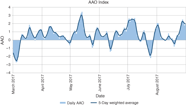
The Southern Annular Mode (SAM, also known as the Antarctic Oscillation or AAO) describes the strength and extent of the southern hemisphere surface westerly winds. Positive phases of the SAM are characterised by increased mass over the mid-latitudes and decreased mass over Antarctica (i.e. anomalously high pressure over the mid-latitudes and anomalously low pressure over Antarctica), and an associated poleward contraction and strengthening in the belt of westerly winds that circles Antarctica. Conversely, negative phases of the SAM related to decreased mass (lower pressure) over the mid-latitudes and increased mass over Antarctica, with an equatorward expansion of the mid-latitude westerly wind belt. A similar oscillation occurs in the northern hemisphere, the Northern Annular Mode (also known as the Arctic Oscillation).
The NOAA’s Climate Prediction Center produces a standardised monthly SAM index.7 Daily values for the SAM index, with a 5-day weighted average, are shown in Fig. 14. The June, July and August 2017 values for the SAM were +0.55, +0.73 and +0.76 respectively, with an overall winter value of +0.68.
|
The MSLP anomaly chart (Fig. 16) shows anomalously low pressure around Antarctica, and higher than average pressure in parts of the mid-latitude region. This is consistent with the overall positive seasonal value of the SAM during winter. A positive phase of the SAM during winter is typically associated with suppressed rainfall across southern Australia (Hendon et al. 2007). It is likely that the SAM contributed in part to some of the drier conditions seen8 in winter 2017 across Australia (see Section 8.1 for Australian region rainfall).
6.2 Surface analyses
The MSLP pattern for winter 2017 is shown in Fig. 15, computed using data from the 0000 hours UTC daily analyses of the Bureau of Meteorology’s Australian Community Climate and Earth System Simulator (ACCESS) model.9 MSLP anomalies are shown in Fig. 16, relative to the 1979–2000 climatology obtained from the National Center for Environmental Prediction (NCEP) II Reanalysis data (Kanamitsu et al. 2002). The MSLP anomaly field is not shown over areas of elevated topography (grey shading).

|

|
The MSLP pattern in winter was zonal around Antarctica, with the subtropical ridge forming a series of high-pressure centres along the 30°S line of latitude. A high-pressure centre was located over the southern Indian Ocean around 90°E (1025.8 hPa) and was part of a band that extended east to another centre over south-eastern Australia (1024.6 hPa) and west to centres over South Africa (1023.9 hPa) and one just off the southern coast of Brazil (1025.0 hPa). The lowest pressures were found off West Antarctica around 150°W (974.2 hPa) in the core of the circumpolar trough.
The anomalies show a three-wave pattern, with the three high-pressure centres each located ~50°S, near 90°E, 150°W and 30°W. They represent an intensification of the dominant three-wave pattern at higher latitudes, consistent with a positive SAM, where the location of the tight gradient shifts closer to the Antarctic coast.
MSLP was more than 7 hPa above average for June across much of southern Australia. Many observing sites with long-term MSLP data observed record high mean 0900 hours MSLP for June, including most of the sites in South Australia and Victoria. This high pressure had an effect on both rainfall and temperature; June was very dry for southern Australia, nights were much cooler than average, and daytime temperatures were warmer than average. Increasing MSLP over southern Australia in winter has been observed in recent decades and is an expected outcome of climate change (Timbal and Drosdowsky 2013).
6.3 Mid-troposheric analyses
The 500 hPa geopotential height, an indicator of the steering of surface synoptic systems across the southern hemisphere, is shown for winter 2017 in Fig. 17. The associated anomalies are shown in Fig. 18. As with the MSLP anomalies, the 500 hPa geopotential height field for winter 2017 was dominated by zonal flow. The anomalies show a three-wave pattern, with the strongest local maxima centred north of West Antarctica around 150°W, with heights of 136 m above average.

|

|
7 Winds
Figures 19 and 20 show winter 2017 low-level (850 hPa) and upper level (200 hPa) wind anomalies respectively (winds computed from ACCESS and anomalies with respect to the 22-year 1979–2000 NCEP climatology). Isotach contours are at an interval of 5 m s−1.

|

|
During winter 2017, a band of low-level (850 hPa) westerly winds circled the globe from ~40 to 60°S and anomalies had local maxima of +12.3 m s−1 centred directly south of New Zealand, +7.1 m s−1 centred southeast of New Zealand and +6.3 m s−1 centred over the Antarctic Peninsula. Weak anomalies through most of the equatorial and tropical South Pacific were consistent with neutral ENSO conditions.
Upper level (200 hPa) wind anomalies showed stronger than average westerly wind flow over much of the Southern Ocean, with the highest anomalies centred around 90°E (+8.6 m s−1) and 120°W (+10.8 m s−1). There were also westerly wind anomalies up to +10.0 m s−1 over the southern half of South America, South Africa and smaller westerly anomalies extending from south-eastern Australia over the South Pacific Ocean, indicative of strengthened jet streams in those regions.
8 Australian region
8.1 Rainfall
Winter rainfall was the ninth-lowest on record for Australia nationally, and the lowest since 2002. Maps of winter rainfall totals and deciles are shown in Fig. 21. Rainfall for the Murray–Darling Basin was also the 10th-lowest on record for winter. Rainfall for the season was below average (below the 30th percentile) for most of Western Australia, most of southern South Australia, the western and southern Top End in the Northern Territory, and across most of the eastern States. Above average rainfall (above the 70th percentile) was restricted to an area of the central Northern Territory, where an out-of-season rainfall event during the second week of July brought totals in excess of 25 mm over a broad area during what is typically the dry season.

|
June was a very dry month for the southeast of Australia and across the west of Western Australia. It was the second-driest June on record for Australia, and driest on record for Victoria. More than 100 of the Bureau of Meteorology's rainfall recording stations with more than 50 years of observations (around 5% of Australia’s long-term rainfall station network) reported their lowest June rainfall total on record, mostly within the southern Murray–Darling Basin. This very dry start to winter was largely due to persistent high-pressure patterns over southern Australia. The subtropical ridge was both stronger, and further south, than usual for this time of year, and the SAM was in a positive phase, leading to fewer rain-bearing low-pressure systems and cold fronts affecting southern Australia.
July was also drier than average across large parts of southern Australia. August saw average to above average rainfall across much of southern Australia, although rainfall for the month was below average in northeast New South Wales and adjacent areas of southern Queensland (Tables 2 and 3).

|

|
8.2 Rainfall deficiencies
Serious to severe rainfall deficiencies at the 3-month timescale emerged in New South Wales during winter 2017 (Fig. 22). At the longer 6-month timescale, serious to severe rainfall deficiencies persisted near the west coast of Western Australia, in Central Australia, and in parts of southwest Queensland.

|
8.3 Temperature
Australian maximum and minimum temperature anomalies for winter 2017 are shown in Figs 23 and 24. Seasonal anomalies are calculated with respect to the 1961–90 period and use high-quality temperature reference stations from the ACORN-SAT network (Trewin 2013). Also shown are the corresponding maximum and minimum temperature deciles, using the same gridded temperature data for all winters between 1910 and 2017.

|

|
For winter 2017, Australia’s mean temperature was very much above average, placing at fifth-warmest on record with an anomaly of +1.11°C (base period 1961–90). Mean temperatures were the second-warmest on record for winter for Queensland, third-warmest for Western Australia and ninth-warmest for the Northern Territory.
Mean maximum temperatures were the highest on record for Australia as a whole, with an anomaly of +1.90°C; the previous record warmest winter was in 2009, with an anomaly of +1.60°C. Daytime temperatures averaged across winter were above average for nearly all of Australia, with more than 90% of Australia by area in decile 10 (Table 4), and large areas of northern Australia observed record high winter daytime temperatures. The year 2017 was the first winter in which more than 90% of the country had mean maximum temperatures that were in decile 10 (Fig. 25). The only areas of the country to have near-average mean maximum temperatures were parts of Victoria, southeast South Australia and Tasmania. State wise, Queensland, Western Australia, and the Northern Territory winter mean maxima were the warmest on record, whereas winter days were the second-warmest on record for South Australia and third-warmest on record for New South Wales (Table 5).

|

|

|
Daytime temperatures were above average for most of Australia during each month on winter. June was particularly warm for the southwest and the third-warmest June on record for Western Australia as a whole (Table 6). July and August were both particularly warm for northern Australia and record warm for large areas of the north in July, in part due to a heat event late in the month that saw record high July daily temperatures in Western Australia, South Australia, Victoria and New South Wales. For Australia as a whole, July mean maxima were the warmest on record. August heat saw a handful of site records set for high August daily temperatures, or warmest temperature so early in the season, at some locations in South Australia and western New South Wales around the middle of the month, and in Western Australia during late August.

|
Australia’s mean minimum temperature anomaly for winter was +0.31°C, which was the lowest winter value since 2014. Mean minimum temperatures were above to very much above average (above the 70th percentile) for most of Queensland and the northern half of the Northern Territory, and areas of Western Australia, mostly in the interior and southwest. Minimum temperatures were below to very much below average (below the 30th percentile) for large areas of south-eastern Australia, with winter nights the coldest since 1997 for the region. Minimum temperatures were also cooler than average for an area of south-eastern Western Australia, and an area spanning the Western Australia–Northern Territory border.
During June, persistent high-pressure systems brought long strings of clear, cold nights, keeping mean minima in decile 1 for the month across much of the southern mainland, and record low for some parts of southern inland New South Wales and northern Victoria. A cold outbreak during the first few days of July saw a number of stations in southern New South Wales and Victoria observe their coldest nights on record.
July mean maxima were particularly mild, and highest on record for much of northern Australia. This was the result of a lack of intrusions of cool air from the south, and a lack of northwest cloudbands keeping skies mostly clear during the month.
Aside from persistent high-pressure anomalies to the south of Australia during June, abnormally high maximum temperatures throughout the rest of winter occurred in the absence of Australia’s most important large-scale climate drivers; ENSO and IOD were both neutral. However, winter temperatures were influenced by secondary climate drivers including warmer than average SSTs to the north and east of Australia, below average rainfall (resulting in lower than average soil moisture and increased numbers of sunny days), and the long-term increasing trend in global air and ocean temperatures.
9 Southern hemisphere
The austral winter of 2017 was warmer than average over almost all land areas in the southern hemisphere and much of the ocean. Averaged over the southern hemisphere as a whole, it was one of the five warmest winters on record.
Of the three major global data sets, winter 2017 ranked as the third-warmest on record for the southern hemisphere in the NOAA data set (Smith and Reynolds 2005), fourth-warmest in the National Aeronautics and Space Administration Goddard Institute for Space Studies data set (Hansen et al. 2010) and fifth-warmest in the United Kingdom Meteorological Office Hadley Centre/Climatic Research Unit, University of East Anglia (HadCRU) data set (Morice et al. 2012). The differences in ranks between the three data sets reflect the different methods they use for assessing temperatures over data-sparse land areas, particularly Antarctica, whilst the uncertainty in temperature measurements is typically greater in the southern hemisphere than the northern due to the lower data density.
Temperatures in winter 2017 were above the long-term average over almost all southern hemisphere land areas outside Antarctica (Fig. 26). Much of northern Argentina and neighbouring areas of Paraguay and Bolivia, areas of South Africa and central Australia had winter mean temperatures 1°C or more above average. New Zealand had winter mean temperatures 0.5°C above the 1981–2010 average, 10 its 11th warmest winter on record.11

|
Figure 27 shows global rainfall patterns for the June to August period. Much of South Africa and neighbouring areas of Namibia and Zimbabwe had less than 50% of their winter average rainfall. The east coast of Argentina, much of Madagascar and Indonesia had a wetter than average winter.

|
Acknowledgements
The authors thank Catherine Ganter and Tamika Tihema for reviewing drafts and providing helpful comments that greatly improved this manuscript. This research did not receive any specific funding.
References
Australian Bureau of Meteorology and CSIRO (2018). State of the Climate. Available at http://www.bom.gov.au/state-of-the-climate/State-of-the-Climate-2018.pdf [Verified 21 April 2020].Chandler, E. (2016). Seasonal climate summary southern hemisphere (winter 2015): mild winter over most of Australia as El Niño strengthens. J. South. Hemisph. Earth Syst. Sci. 66, 68–89.
| Seasonal climate summary southern hemisphere (winter 2015): mild winter over most of Australia as El Niño strengthens.Crossref | GoogleScholarGoogle Scholar |
Hansen, J., Ruedy, R., Sato, M., and Lo, K. (2010). Global surface temperature change. Rev. Geophys. 48, RG4004.
| Global surface temperature change.Crossref | GoogleScholarGoogle Scholar |
Hendon, H., Thompson, D. W. J., and Wheeler, M. C. (2007). Australian rainfall and surface temperature variations associated with the southern hemisphere annular mode. J. Clim. 20, 2452–2467.
| Australian rainfall and surface temperature variations associated with the southern hemisphere annular mode.Crossref | GoogleScholarGoogle Scholar |
Kanamitsu, M., Ebisuzaki, W., Woollen, J., Yang, S. -K., Hnilo, J. J., Fiorino, M., and Potter, G. L. (2002). NCEP-DOE AMIPII reanalysis (R-2). Bull. Am. Met. Soc. 83, 1631–1643.
| NCEP-DOE AMIPII reanalysis (R-2).Crossref | GoogleScholarGoogle Scholar |
Kuleshov, Y., Qi, L., Fawcett, R., and Jones, D. (2009). Improving preparedness to natural hazards: tropical cyclone prediction for the Southern Hemisphere. Adv. Geosci. 12, 127–143.
| Improving preparedness to natural hazards: tropical cyclone prediction for the Southern Hemisphere.Crossref | GoogleScholarGoogle Scholar |
Martin, D. J. (2016). Seasonal climate summary southern hemisphere (spring 2015): El Niño nears its peak. J. South. Hemisph. Earth Syst. Sci. 66, 228–261.
| Seasonal climate summary southern hemisphere (spring 2015): El Niño nears its peak.Crossref | GoogleScholarGoogle Scholar |
Morice, C. P., Kennedy, J. J., Rayner, N. A., and Jones, P. D. (2012). Quantifying uncertainties in global and regional temperature change using an ensemble of observational estimates: the HadCRUT4 dataset. J. Geophys. Res. 117, D08101.
| Quantifying uncertainties in global and regional temperature change using an ensemble of observational estimates: the HadCRUT4 dataset.Crossref | GoogleScholarGoogle Scholar |
Pepler, A. S. (2016). Seasonal climate summary southern hemisphere (summer 2015–16): strong El Niño peaks and begins to weaken. J. South. Hemisph. Earth Syst. Sci. 66, 361–379.
| Seasonal climate summary southern hemisphere (summer 2015–16): strong El Niño peaks and begins to weaken.Crossref | GoogleScholarGoogle Scholar |
Reynolds, R. W., Rayner, N. A., Smith, T. M., Stokes, D. C., and Wang, W. (2002). An improved in situ and satellite SST analysis for climate. J. Clim. 15, 1609–1625.
| An improved in situ and satellite SST analysis for climate.Crossref | GoogleScholarGoogle Scholar |
Risbey, J. S., Pook, M. J., McIntosh, P. C., Wheeler, M. C., and Hendon, H. H. (2009). On the remote drivers of rainfall variability in Australia. Mon. Wea. Rev. 137, 3233–3253.
| On the remote drivers of rainfall variability in Australia.Crossref | GoogleScholarGoogle Scholar |
Saji, N. H., Goswami, B. N., Vinayachandran, P. N., and Yamagata, T. (1999). A dipole mode in the tropical Indian Ocean. Nature 401, 360–363.
| A dipole mode in the tropical Indian Ocean.Crossref | GoogleScholarGoogle Scholar |
Smith, T. M., and Reynolds, R. W. (2005). A global merged land air and sea surface temperature reconstruction based on historical observations (1880-1997). J. Clim. 18, 2021–2036.
| A global merged land air and sea surface temperature reconstruction based on historical observations (1880-1997).Crossref | GoogleScholarGoogle Scholar |
Timbal, B., and Drosdowsky, W. (2013). The relationship between the decline of Southeastern Australian rainfall and the strengthening of the subtropical ridge. Int. J. Climatol. 33, 1021–1034.
| The relationship between the decline of Southeastern Australian rainfall and the strengthening of the subtropical ridge.Crossref | GoogleScholarGoogle Scholar |
Trewin, B. C. (2013). A daily homogenized temperature data set for Australia. Int. J. Climatol. 33, 1510–1529.
| A daily homogenized temperature data set for Australia.Crossref | GoogleScholarGoogle Scholar |
Troup, A. (1965). The southern oscillation. Q. J. R. Meteorol. Soc. 91, 490–506.
| The southern oscillation.Crossref | GoogleScholarGoogle Scholar |
Wang, G., and Hendon, H. H. (2007). Sensitivity of Australian rainfall to inter-El Niño variations. J. Clim. 20, 4211–4226.
| Sensitivity of Australian rainfall to inter-El Niño variations.Crossref | GoogleScholarGoogle Scholar |
1 The Troup Southern Oscillation Index (Troup 1965) used in this article is 10 times the standardised monthly anomaly of the difference in mean sea level pressure (MSLP) between Tahiti and Darwin. The calculation is based on 60-year climatology (1933–92), with records commencing in 1876. The Darwin MSLP is provided by the Bureau of Meteorology, and the Tahiti MSLP is provided by Météo France interregional direction for French Polynesia.
2 The 5VAR ENSO index was developed by the Bureau of Meteorology and is described by Kuleshov et al. (2009). The principal component analysis and standardisation of this ENSO index is performed over the period 1950–99.
3 SST indices obtained from ftp://ftp.cpc.ncep.noaa.gov/wd52dg/data/indices/sstoi.indices, verified 21 April 2020.
4 Obtained from http://www.cpc.ncep.noaa.gov/data/indices/olr, verified 21 April 2020.
5 http://www.bom.gov.au/oceanography/oceantemp/pastanal.shtml, verified 21 April 2020.
6 Data from National Snow and Ice Data Center (https://nsidc.org/arcticseaicenews/charctic-interactive-sea-ice-graph/, verified 21 April 2020).
7 Climate Prediction Center (NOAA) AAO index since January 1979, see http://www.cpc.ncep.noaa.gov/products/precip/CWlink/daily_ao_index/aao/aao.shtml, verified 21 April 2020.
8 Hovmöller plot obtained from http://www.pmel.noaa.gov/tao/jsdisplay/, verified 21 April 2020.
9 For more information on the Bureau of Meteorology’s ACCESS model, see http://www.bom.gov.au/nwp/doc/access/NWPData.shtml, verified 21 April 2020.
10 A subset of the full temperature network is used to calculate the spatial averages and rankings shown in Table 5 (maximum temperature), Table 6 (minimum temperature) and Table 4; this dataset is known as ACORN-SAT (see http://www.bom.gov.au/climate/change/acorn-sat/, verified 21 April 2020, for details). The values shown above are from v1 of the ACORN-SAT dataset; v2 has replaced v1 from the start of 2018. These averages are available from 1910 to the present. As the anomaly averages in the tables are only retained to two decimal places, tied rankings are possible. Rankings marked with ‘=’ denote tied rankings.
11 See the New Zealand winter 2017 climate summary by NIWA, https://www.niwa.co.nz/climate/summaries/seasonal/winter-2017, verified 21 April 2020.