

Variability in wildland fuel patches following high-severity fire and post-fire treatments in the northern Sierra Nevada
Ian B. Moore A F , Brandon M. Collins B C , Daniel E. Foster A , Ryan E. Tompkins D , Jens T. Stevens E and Scott L. Stephens A
A Department of Environmental Science Policy and Management, University of California, 130 Mulford Hall No. 3114, Berkeley, CA 94720-3114, USA.
B USDA Forest Service, Pacific Southwest Research Station, Davis, CA 95618, USA.
C Center for Fire Research and Outreach, College of Natural Resources, University of California, Berkeley, CA 94720-3114, USA.
D University of California Cooperative Extension: Plumas, Sierra, and Lassen Counties, Quincy, CA 95971, USA.
E US Geological Survey, Fort Collins Science Center, New Mexico Landscapes Field Station, 301 Dinosaur Trail, Santa Fe, NM 87508, USA.
F Corresponding author. Email: imoore@berkeley.edu
International Journal of Wildland Fire 30(12) 921-932 https://doi.org/10.1071/WF20131
Submitted: 22 August 2020 Accepted: 18 September 2021 Published: 27 October 2021
Journal Compilation © IAWF 2021 Open Access CC BY-NC-ND
Abstract
Surface fuel loads are highly variable in many wildland settings, which can have many important ecological effects, especially during a wildland fire. This variability is not well described by a single metric (e.g. mean load), so quantifying traits such as variability, continuity and spatial arrangement will help more precisely describe surface fuels. This study measured surface fuel variability in the northern Sierra Nevada of California following a high-severity fire that converted a mixed-conifer forest to shrub-dominant vegetation, both before and after a subsequent shrub removal treatment conducted as site preparation for reforestation. Data were collected on vegetation composition, spatial arrangement and biomass load of the common surface fuel components (1–1000-h woody fuel, litter, duff and shrubs). Mean shrub patch length decreased significantly from 9.25 to 1.0 m and mean dead and down surface fuel load decreased significantly from 131.4 to 73.4 Mg ha−1. Additionally, probability of encountering a continuous high fuel load segment decreased after treatment. This work demonstrates a method of quantifying important spatial characteristics of surface fuel that could be used in the next generation of fire behaviour models and provides metrics that land managers may consider when designing post-fire reforestation treatments.
Keywords: fine fuels, woody debris, fuel load, fuel heterogeneity, fuel model, forest structure, mixed conifer, spatial variability.
Introduction
Fire regimes in dry conifer forests across much of the western United States have been disrupted by changes in land management and climate (Westerling et al. 2006; Hessburg et al. 2016). In the mixed-conifer forests common throughout the Sierra Nevada mountain range, the historical regime of frequent low- to moderate-severity fire has been shifted towards a regime of infrequent high-severity fires with large patch sizes (North et al. 2009; Stephens et al. 2015; Safford and Stevens 2017; Steel et al. 2018). When these forests experience high-severity fire, especially in large patches, there is a threat of long-term conversion to a shrub-dominated (Coppoletta et al. 2016; Coop et al. 2020) state because of long seed dispersal distances and competition from shrubs (Shive et al. 2018; Tubbesing et al. 2021).
Repeat wildfires increase the risk of forest loss through type conversion. Dense shrub fields can establish in previous fire footprints among an intermix of snags and high accumulations of large down woody debris. This fuel environment, when combined with increasing high-severity proportion and patch size, creates fuel conditions that are far departed from these forests’ natural fire regime in terms of continuity and extent and consequently are vulnerable to re-burning at high severity (Coppoletta et al. 2016; Lydersen et al. 2019). Limited success of natural regeneration after large stand-replacing fires highlights the need for reforestation in post-fire environments (Collins and Roller 2013), though plantations established after fires may also be vulnerable to high-severity fire effects (Stephens and Moghaddas 2005a; Thompson et al. 2007; Zald and Dunn 2018). Reforestation treatments can maximise chances of success by addressing all three issues with artificial regeneration, removal and control of competing vegetation, and reduction or rearrangement of surface fuels. As a result, decisions regarding how to manage the development of fuel profiles in early seral post-fire environments will become more frequent, more complex and increasingly important for determining management actions (Meyer et al. 2021).
Reforestation efforts in post-fire environments often involve salvage logging, site preparation, and mechanical or chemical vegetation control methods paired with planting to establish trees (Zhang et al. 2008; Stephens et al. 2020). These management actions are designed to reduce shrub competition and increase growth rates of planted seedlings (McDonald and Fiddler 2010; Zhang et al. 2013), but can also reduce wildfire risk by lowering overall fuel loads of dead woody debris and live shrub cover. Modification of fuel profiles and removal of shrubs via site preparation and vegetation control treatments may also increase the spatial variability of both dead and live fuels.
Surface fuels include detached plant material, herbs, grasses, forbs, and shrubs lying within 2 m of mineral soil (Keane et al. 2012) and are particularly important to fire-prone ecosystems. Surface fuels can provide habitable conditions for flora and fauna, control erosion and store carbon. Increased surface fuel loads can increase surface fire flame lengths (Albini 1976), which increases the potential for initiation and propagation of crown fires (Agee and Skinner 2005). Smouldering combustion of the duff layer can increase smoke emissions and tree mortality (Stephens and Finney 2002) while also reducing regeneration potential (Webster and Halpern 2010).
Given the importance of surface fuels, accurately capturing their abundance and distribution is highly desirable. However, surface fuels exhibit complex spatial variability within stands and across landscapes (Arroyo et al. 2008; Keane et al. 2012; Keane 2013). Different components of dead and down surface fuel (litter, duff, fine woody, coarse woody) exhibit spatial dependence at different scales (Fry and Stephens 2010; Keane et al. 2012; Vakili et al. 2016). These individual components are only weakly correlated with each other (Brown and See 1981; Brown and Bevins 1986; Keane et al. 2012), and somewhat correlated with forest stand characteristics (Fry and Stephens 2010; Lydersen et al. 2015).
While challenging, quantifying the spatial variability of surface fuels may be essential to developing a more mechanistic understanding of wildland fire spread and effects (Finney et al. 2015). In burned ecosystems, the uneven distribution of fuels and their combustion can drive mortality, growth and regeneration dynamics (DeBano et al. 1998; Blomdahl et al. 2019), which in turn can drive future fuel distributions and fire behaviour (Fry et al. 2018; Lydersen et al. 2019). There is a growing body of evidence that the fine-scale (sub-hectare) spatial arrangement of fuels plays an important role in driving fire behaviour and effects (Hiers et al. 2009; Wiggers et al. 2013; Loudermilk et al. 2014). Simulation studies indicate that the fine-scale arrangement of canopy fuels has important effects on modelled wildfire behaviour (Ziegler et al. 2017; Ritter et al. 2020; Atchley et al. 2021). Fine-scale discontinuities in fuel can influence the direction, speed and intensity of the fire front (Thaxton and Platt 2006; King et al. 2008; Hiers et al. 2009) with profound implications for fire effects, even when the discontinuities are insufficient to halt fire spread entirely.
While fine-scale variability in fuels is critical to fire behaviour, our ability to model observed wildland fire behaviour is limited by the overly simplistic assumptions of current fuel characterisation systems, which do not precisely quantify variability (Finney 2004; Andrews 2014). For instance, the Fuel Characteristic Classification System attempts to capture vertical heterogeneity in wildland fuels at a fine resolution in order to predict fire behaviour, but it assumes horizontal continuity at the scale of 30-m pixels (Ottmar et al. 2007; Riccardi et al. 2007). There remains a lack of standardised procedures to describe wildland fuel variability at finer scales. This limitation not only hampers assessments of extant wildfire hazard, but also our ability to predict smoke emissions (Ottmar 2014), quantify the stability of carbon pools (Hurteau and North 2009; Foster et al. 2020), and plan hazard mitigation to protect communities and resources (Reinhardt and Keane 1998; Andrews 2008). Wildfire managers rely on operational tools to make these assessments and predictions and ultimately fire and land management decisions. Improving descriptions of fuel abundance and their spatial variability is a necessary step towards making better decisions.
There is a critical need for better fine-scale fuel descriptions to support the expected increase of post-fire fuel management decisions for severely burned areas. To this end, the present study (i) quantified the distribution and continuity of post high-severity-fire fuel patches; (ii) made predictions of fuel patch continuity; (iii) described spatial dependence of surface fuels in post-fire vegetation; and (iv) evaluated the efficacy of site preparation and vegetation control in managing fuel loads in post-fire environments. The initial hypotheses for (iv) were that surface fuel loads would be high and fairly continuous post wildfire, but that site preparation treatment would reduce fuel loading and continuity.
Methods
Study area
The study area was located in the northern Sierra Nevada within the Plumas National Forest (PNF). This area experiences a Mediterranean climate with warm, dry summers and cool, wet winters. Annual precipitation from 1985 to 2017 averaged 1036 ± 306 mm, and the majority falls in the winter months as snow. Mean temperatures varied from 1.3°C in January to 19.3°C in July (Western Regional Climate Center, 2017: https://wrcc.dri.edu/cgi-bin/cliMAIN.pl?ca7195). Montane vegetation is dominated by ponderosa pine (Pinus ponderosa), white fir (Abies concolor) and Douglas-fir (Pseudotsuga menziesii). Additionally, Jeffery pine (Pinus jeffreyi), sugar pine (Pinus lambertiana), incense-cedar (Calocedrus decurrens) and oak (Quercus spp.) populate the region along with patches of montane chaparral (primarily Arctostaphylos and Ceanothus spp.) (North et al. 2016). Prior to fire suppression, this region experienced frequent (8–22-year interval) low- to moderate-severity fire (Moody et al. 2006) as a result of natural ignitions and Indigenous burning practices. Fire suppression and logging beginning in the early 1900s has led to an increased density of trees and a resulting increase in large, high-severity fires (Safford and Stevens 2017; Lydersen and Collins 2018).
On 3 September 2007, a fire was ignited in the Moonlight Valley (40.22791°N 120.84710°W). The Moonlight Fire burned 26 000 ha, which included very large high-severity patches of total or near total tree mortality. Owing to unsuccessful and unimplemented reforestation efforts, these high-severity patches developed high-density continuous shrub cover with little to no conifer regeneration (Stephens et al. 2020) (Fig. 1a).

|
Study design
PNF staff targeted areas within the Moonlight Fire perimeter for reforestation treatment. These areas had been mature mixed-conifer forests before the fire, but experienced high-severity effects that led to colonisation by large stature shrubs (primarily Ceanothus spp.). Thirty study plots, grouped into five spatial blocks, were established by geographic information system (GIS) within the boundaries of the reforestation areas. Plots were clustered into five spatial blocks (six plots per block) and were located on areas with at least 25% shrub cover in 2013 (as indicated by a vegetation cover raster generated from aerial LiDAR data), which is the type of heavy shrub environment that is most likely to require site preparation, reforestation and competing vegetation control to meet plantation desired conditions (USDA Forest Service 2004). Plots were 90 × 90-m squares aligned on cardinal directions, with sampling occurring in three 90-m transects that ran west–east and were separated north–south by 22.5 m from each other and from the northern and southern boarders of the plot. Each 90-m transect was divided into three 30-m sub-transects where fuels, ground cover and seedling counts were recorded (Fig. 2).

|
All reforestation sites received a site preparation treatment in the fall (autumn) of 2018. The objectives of the site preparation treatment for planting included reducing competing vegetation, mitigating safety hazards posed by a prevalence of snags, and breaking up the continuity of live shrub and dead woody fuels to improve plantation resistance to future fires. The site preparation treatment utilised an excavator to pull shrubs, fell snags and pile downed woody debris, and debris piles were burned during the fall and winter period before spring planting. The silvicultural prescription for the site preparation treatment included variable retention of shrub patches, existing large down woody debris, and high-value snags for wildlife habitat and large down woody debris recruitment goals. Each of the six plots within a block was randomly assigned one of six experimental treatments (Fig. 2). The six treatments were the result of crossing two planting arrangements (even-spaced and clustered) with three types of competing vegetation control treatments (herbicide, hand grubbing, and no treatment), which occurred in the spring of 2019. Note that given the timing of data collection for this work, we did not evaluate efficacy of planting or competing vegetation control treatments. The silvicultural prescription for the herbicide and hand grubbing treatments specified treatment of existing and sprouting vegetation within a 1.5-m radius of planted trees; thus, the planting treatment influenced the spatial pattern of shrub cover via post-planting treatments.
Data collection
Pre-treatment data were collected in the summers of 2017 and 2018, before the site preparation treatments were applied. Post-treatment data (after site preparation, planting and vegetation control) were recorded in August 2019. For each 30-m sub-transect (Fig. 2), the following were recorded:
-
Dead and down surface fuels: The 30-m sub-transect was divided into three segments where the planar intercept method was used to measure dead and down surface fuels based on time lag classifications (Brown 1974). Starting at 3, 13 and 23 m from the beginning of the sub-transect, 1-h (<0.64 cm) and 10-h (0.64–2.54 cm) woody fuels were tallied for 3 m (3–6, 13–16, 23–26 m). The 100-h (2.54–7.62 cm) woody fuels were tallied for 4 m (3–7, 13–17 and 23–27 m) and 1000-h (>7.62 cm diameter) woody fuels were tallied along the entirety of the 30-m sub-transect. Litter (identifiable needles and leaves) and duff (unidentifiable organic matter) depth, measured in centimetres, were recorded at the beginning and end of the 100-h sampling segments (3, 7, 13, 17, 23 and 27 m).
-
Vegetation and ground cover: Along the entire 30-m sub-transect, live vegetation cover was recorded using the planar intersection method (Canfield 1941). The 30-m sub-transect was divided into 0.25-m samples, and for each sample, crews recorded the species and height (nearest 0.25 m) of the dominant vegetation (tallest vegetation with more than 50% cover along the sampling line). Where live vegetation did not cover 50% of the sampling line or was overtopped by another category (e.g. a down log), crews recorded the dominant cover (bare ground, rock, litter, fine woody debris, or coarse woody debris).
Data analysis
Fuel tallies and depths were converted into estimates of fuel loads (Mg ha−1) for each fuel component (duff, litter, 1-, 10-, 100-, 1000-h) using the Rfuels package (Foster et al. 2018). Woody fuels were aggregated into the categories of fine woody debris (1-, 10- and 100-h fuels, FWD) and coarse woody debris (1000-h fuels, CWD). Bulk density of litter and duff was not measured so equations that relate depth to weight for litter and duff of common conifer species in the area were used (van Wagtendonk et al. 1998). Overstorey tree composition is usually used to convert fuel tallies to load values (Brown 1974) but because there was no overstorey present on the study site, a generic all species coefficient that is representative of Sierran conifer species was used (van Wagtendonk et al. 1996, 1998). Additionally, these estimates were summed to produce an estimate of FWD (includes 1-, 10- and 100-h), fine surface fuel (FWD and litter), and total dead and down surface fuel (litter, duff, FWD and CWD) at each segment of the sub-transect. Shrub cover was calculated as a percentage of each sub-transect that intersected shrub canopies, and then scaled up to the entire plot for biomass measurements based on the proportion of the plot that each sub-transect represents. Shrub biomass was calculated using equations from McGinnis et al. (2010b) relating individual crown diameter and plant height to biomass. Since crown diameter was not measured directly on the transect, percentage cover by species for each sub-transect was divided by species mean crown area (from mean crown diameter; McGinnis et al. 2010b) to produce an estimate of the number of individuals per hectare. This estimate could be used in conjunction with the species mean crown diameter and the (observed) mean height (McGinnis et al. 2010b) to estimate biomass per hectare for each species represented by the observed cover and mean height on each sub-transect. Standard deviations were calculated using the 30-m sub-transect as the sample unit. Effects of site preparation on fuel load by category (litter, duff, FWD, CWD, total dead and down surface fuel) were determined using linear mixed effects models with the 30-m sub-transect as the sample unit. The response variable for each model (fuel loading in a given category) was log-transformed to meet model assumptions of normality.
Data analysis: patch lengths and distribution
Ground cover and vegetation patches were defined as any uninterrupted segment of cover and could range from the smallest unit of measurement (0.25 m) to the length of the sub-transect (30 m). Cover patch lengths were merged into five cover types that include shrub, grass, forb, dead and down surface fuel (including CWD, FWD and litter), and bare ground. If a sub-transect started with the same cover type that the preceding sub-transect (of the same 90-m transect) ended with, the two patches were merged into one, with the patch lengths of each summed together. Additionally, the reflection method (Gregoire and Monkevich 1994) was employed that tied the start and end of each transect together. If the cover type was the same at both ends, the two patches were merged into one patch whose length was the sum of each original patch. Patch lengths could not exceed the length of the transect (90 m). This method was chosen since the patch lengths at the ends of the transects were truncated values (i.e. the patch could have continued beyond where sampling ended) and this method provided an efficient way to analyse the data and did not change the distributions of patch lengths considerably.
In addition to attributing patches based on cover type as described above, patches were also attributed based on the height of the dominant cover type. ‘Tall fuel’ comprised tall shrubs >0.5 m height, ‘short fuel’ comprised short shrubs ≤0.5 m, grasses, forbs, and woody debris, and ‘no fuel’ included bare ground and rock. For statistical tests, patch lengths were log-transformed to meet the assumption of normality. To test the number of patches (by cover type and height class) per transect, a generalised linear mixed model (GLMM) was run using a generalised Poisson model (Eqn 1) with a dispersion parameter (η) because the standard Poisson (Var = μ) was overdispersed.

Data analysis: surface fuel loads and neighbourhood probability
In addition to describing patches of specific cover types as stated above, the spatial configuration of surface fuels (dead and down fuels plus live fuels, particularly shrubs) was characterised in 10-m segments along our transects, determined by the scale of Brown’s (1974) sampling. Each 10-m segment of a 90-m transect was assigned a fuel value based on Brown’s sampling of that segment and the percentage coverage by shrubs. Segments were classified as ‘high’ fuel loads and assigned a value of one if they equalled or surpassed the 75th percentile of fine surface fuel loads pre-treatment (14.3 Mg ha−1) and/or if tall shrub cover equalled or exceeded 50%. Fine surface fuels include litter, 1-, 10- and 100-h fuels. The same process was repeated for the 90th percentile fine fuel load (18.9 Mg ha−1). The 75th and 90th percentile of fine surface fuel loads pre-treatment were chosen to display a range of conditions for the fuel type that is currently not well quantified by one of the standard fuel models. Live shrub cover equal to or greater than 50% was the threshold used for undesirable fuel conditions as this threshold corresponds with the management standards and guidelines for plantations that specify desired conditions of shrub cover <50% (USDA Forest Service 2004). Segments were classified as ‘low’ fuel loads and assigned a value of zero if neither of these conditions were met. For each segment, probability that a randomly chosen neighbour (an adjacent 10-m segment) was classified as ‘high’ fuel load was equal to the average of the binary values of its neighbours. The starting (west) segment of the transect used the end (east) segment of the same transect as its left neighbour. The end segment used the starting segment of the same transect as its right neighbour. This was consistent with the reflection method employed for vegetation.
For both pre and post site preparation, probabilities of a ‘high’ fuel load neighbour were determined for the entire study site and for ‘high’ load segments using the mean of the binary neighbour average. Gaps were defined as any segments that had ‘low’ fuel loads. Projecting ‘high’ fuel loads out to the nth neighbour was achieved by taking the overall probabilities of ‘high’ fuel loads and multiplying them by the probability of ‘high’ fuel loads given a known ‘high’ fuel load start as is consistent with conditional probability of dependent events (Eqn 2).

where Sn = ‘high’ fuel load at nth step, A = neighbour segment ‘high’ fuel load, H = current segment ‘high’ fuel load, n = number of steps (in 10-m increments).
Gap projections used the probability of a neighbour having ‘low’ load class (Eqn 3).

where Sn = ‘low’ fuel load at nth step, B = neighbour segment ‘low’ fuel load, L = current segment ‘low’ fuel load, n = number of steps (in 10-m increments).
All analyses were done in R (R Core Team 2018) using nlme (Pinheiro et al. 2020).
Results
Patch lengths and distribution
Across the study area, shrub cover decreased from 84% before treatment to 21% after treatment and the cover became more discontinuous. From pre to post site preparation, median shrub patch length decreased from 3.5 to 0.75 m while mean patch length decreased from 9.25 m (s.d. 14.9 m) to 1.0 m (s.d. 1.1 m) (P value < 0.0001) (Fig. 3). The number of individual shrub patches more than doubled between pre and post site preparation. Median bare ground patch length increased from 1 m (mean 1.4, s.d. 1.4) to 1.25 m (mean 1.8, s.d. 1.7) (P value 0.0023). Notably, the total number of bare ground patches across all transects sampled pre and post site preparation increased almost 6-fold from 286 to 1665. Forb patches decreased from a median of 0.75 m (mean 1.1, s.d. 1.1) to 0.5 m (mean 0.8, s.d. 0.75) although the effect of year was not significant. However, the number of these patches doubled from 159 to 370. Median patch length for grass and dead and down surface fuels remained the same; however, the number of grass patches increased from 200 to 740 and the number of dead and down surface fuel patches increased by a factor of 5 from 303 to 1526. When grouped into cover classes, a GLMM showed a strong effect (z value = 7.265, Pr(>|z|) = 7.73 × e−13) of site preparation on the number of patches per transect, indicating more instances of discontinuities.

|
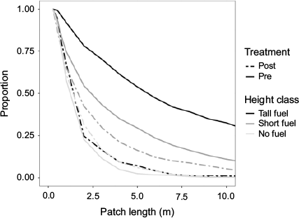
Overall continuity of tall shrubs (>0.5 m), quantified by the prevalence of long patches, decreased. Between pre and post site preparation, the proportion of tall fuel patch lengths decreased at each size class while the proportions for short fuel and no-fuel patch lengths remained more consistent (Fig. 4). Pre site preparation, 54% of tall fuel patch lengths were greater than or equal to 5 m, while post site preparation, only 7% of tall fuel patch lengths were greater than or equal to 5 m. The proportions of short fuel patch lengths greater than or equal to 5 m decreased from 30% to 16% between pre and post site preparation. In contrast, the proportions of no-fuel patch lengths 5 m or more increased from 2% to 6% from pre to post site preparation. Overall, there was a reduction in the number of large, tall fuel patch lengths (Fig. 4).
|
Surface fuel loads
Total surface fuel load decreased between pre and post site preparation (Table 1). Initial dead and down surface fuel loads averaged 131.4 Mg ha−1 and were reduced to 73.4 Mg ha−1 after site preparation. Most of this reduction was due to decreases in 1000-h fuels, which were reduced from an average of 102.8 to 57.8 Mg ha−1. Reductions in duff load also contributed to the decrease in the overall fuel load. Average duff load pre site preparation was 17.7 Mg ha−1 (s.d. 22.7) and fell to 1.1 Mg ha−1 (s.d. 3.3) post site preparation. In addition, litter load was reduced from 5.2 Mg ha−1 (s.d. 2.9) to 2.6 Mg ha−1 (s.d. 2.6). While total dead and down surface fuel load was reduced, increases in 1-, 10-, and 100-h fuels did occur. One-hour fuels increased from 0.1 to 0.9 Mg ha−1, 10-h fuels increased from 1.2 to 4.0 Mg ha−1, and 100-h fuels increased from 4.5 to 7.0 Mg ha−1. Live surface fuel (shrub biomass) decreased from an average of 0.1 to 0.003 Mg ha−1. The linear mixed-effects model on log-transformed values in each fuel category showed a statistically significant (P < 0.05) effect of year on fuel load for each category except FWD.

|
Neighbour probability
The probability of a 10-m fuel and shrub segment of ‘high’ surface fuel load decreased post site preparation (Fig. 5). Using the 75th percentile cut-off, 74% of all segments pre site preparation were classified as high fuel load, while post site preparation, the same conditions accounted for 42% of all segments. Based on the 90th percentile cut-off, 69% of segments were classified as high load pre site preparation. This decreased to 31% post site preparation. For high load segments before site preparation, the probability of a neighbour also having high load criteria was ~80% for both the 75th and 90th percentile cut-offs. The probability of a continuous 40-m segment of high fuel load was 44% and 41% for the 75th and 90th percentile cut-offs, respectively. Post site preparation, the same probability decreased drastically to 6% and 1% (Fig. 5). Pre site preparation, the probability of a low-load segment having a low-load neighbour, subsequently referred to as a gap, was 50% and 56% for the 75th and 90th percentile cut-offs, respectively. This same gap probability increased to 66% and 84% after site preparation.

|
Discussion
This study quantified surface fuels in a post-wildfire landscape using a spatial approach to assess fine-grained (<30 m) spatial properties of fuels. A more common practice would have been to report average dead and down surface fuel load and average shrub cover. Both of these were quite high throughout our study sites before treatment (131.4 Mg ha−1 dead and down surface fuel load, and 84% shrub cover), and changed dramatically following treatment (74.3 Mg ha−1 dead and down surface fuel load, and 21% shrub cover). However, these averages do little to explain the spatial properties of fuel in burned forests, which can be highly heterogenous (Lydersen et al. 2019). Our approach for assessing these spatial properties of both downed fuels and shrubs advances understanding of fuel continuity, which is an important characteristic of wildland fuel beds (Hiers et al. 2009).
Small changes (0.25 m) to average bare ground patch length, decreased shrub patch length (Fig. 3) and increased frequency of both patches suggest more fragmentation of shrubs by bare ground patches at fine scales owing to site preparation treatments. This increased discontinuity can also be recognised by the decreased proportion of larger patches by fuel height (Fig. 4). Continuous patches of tall shrubs extending for more than 5 m are infrequent post site preparation. Patch lengths of short-stature fuels (including short shrubs, grasses, forbs and down surface fuels) also decreased from pre to post site preparation, but these changes were far less pronounced (Fig. 4). This is consistent with modest overall change in FWD from pre to post site preparation (Table 1), which has also been demonstrated in other studies on mechanical post-fire treatments (McIver and Ottmar 2007; McGinnis et al. 2010a). The lack of strong change in these smaller fuels following these treatments is not too surprising given that these fuels are not easily manipulated with the heavy equipment used for site preparation.
Overall surface fuel continuity, including fine woody material and shrubs, may not be measurable in the same way as with shrub patches alone. As such, we relied on a neighbourhood analysis to describe the spatial configuration of ‘high’ and ‘low’ surface fuel load clusters (Fig. 5). This allowed us to differentiate fuel clusters based on their potential to contribute to problematic fire behaviour. The probability of finding long clusters of high fuel loads using the 75th percentile cut-off noticeably decreased from pre to post site preparation (Fig. 5a). The decreases are even more pronounced when using the 90th percentile fuel load as the cut-off value (Fig. 5b). While low fuel gaps were evident before site preparation, accounting for a total of 26% of all 10-m segments, there was a ~70–80% likelihood such gaps were less than 20 m in length (depending on the threshold value for fine surface fuel load). Following site preparation, the same likelihood decreased to ~30–55%, indicating a much greater chance that low fuel gaps would extend beyond 20 m. Given the importance of fuel discontinuity in fire spread (Finney et al. 2010; Atchley et al. 2021), describing spatial properties of both high and low fuel load patches is critical for understanding which areas may be heat sinks and which may be heat sources.
It has already been shown that shrub establishment can be extensive following high-severity fire in mixed-conifer forests (Miller et al. 2009; Coppoletta et al. 2016) and that logging fire-killed trees and removing shrubs significantly reduce vegetation cover and fuels (McGinnis et al. 2010a). While our findings corroborate those results, our methods provide further details of surface fuels that are not explored by conventional methods. However, our methods and analysis could be improved by differentiating between the various species, especially in the shrub category, which can have a significant effect on fire behaviour. One species dominated the shrublands in this study: Ceanothus cordulatus accounted for 93% of shrub cover pre site preparation and 92% post site preparation. Incorporating species flammability traits (due to chemical makeup or moisture content) into future analysis would likely better capture the characteristics of the fuel bed as it relates to fire behaviour. Additionally, this linear analysis could be expanded into two dimensions to further the fuel bed description.
Improvements to the study design could be made by being spatially explicit as to where CWD crossed the transect and its orientation. Our CWD data only had a resolution of 30 m and the mismatch in resolution with our other fuel variables complicates comparisons. While CWD does not play a significant role in the propagation of the fire front (Rothermel 1972), it comprised nearly 78% of total fuel load before and after site treatment on our study site and can have significant effects on fire severity and other ecological processes (Stephens and Moghaddas 2005b; Lydersen et al. 2019). Significant effects of follow-up treatment on CWD load (and total fuel, likely due to the large component of CWD) were found but an explanation for this remains unclear. Herbicide, grubbing or lack thereof is not intended or expected to alter CWD. Pile burning is conducted during site preparation to reduce CWD load and effects of site preparation on CWD load were significant.
The need for managing fuels in post-high-severity fire environments has become increasingly apparent given recent trends in severe fire occurrence (Stevens et al. 2017). However, the current suite of surface fuel models commonly used in the United States (Scott and Burgan 2005) does not accurately capture the combination of live shrubs with a preponderance of fire-killed snag fall that often develops following high-severity fire in forests (McGinnis et al. 2010a; Lydersen et al. 2019). Modelling by Dunn and Bailey (2015) suggests that CWD fuels may persist in post-fire landscapes for decades as 1000-h fuels. Furthermore, recent research suggests that recently burned areas with high shrub establishment and/or high amounts of CWD are prone to severe reburns (Coppoletta et al. 2016; Lydersen et al. 2019). Consequently, reforestation efforts may benefit from management of live shrub fuels and CWD fuels that primarily reduce severity of subsequent fires (i.e. reburns) to improve the likelihood of tree establishment and survival over time. Furthermore, given the potential for shrubs to re-colonise following site preparation treatments, managers may need to consider additional vegetation control to meet restoration objectives. Prescribed fire is being proposed in young plantations to reduce fuels and ultimately mitigate wildfire hazard (Reiner et al. 2009; Bellows et al. 2016). The immediate post-treatment results reported in the present study may inform early opportunities to reintroduce prescribed fire to manage surface fuel loads.
For management purposes, this study illustrates a new quantification of shrub establishment that occurred following high-severity fire in mixed-conifer forests and shrub reduction following site treatments. Shrub dominance can almost completely limit the natural regeneration of tree seedlings (Tubbesing et al. 2020) and can also create fuel conditions favourable to another high-intensity, high-severity fire (McGinnis et al. 2010a; Coppoletta et al. 2016). These findings suggest that site preparation and vegetation control may be an effective tool to reduce fuel loads and break up the continuity of live and downed woody fuels in early seral environments created by high-severity fire. Furthermore, the patch length distributions and neighbour probability metrics indicate that these treatments can help promote finer-scale heterogeneity while still retaining live shrub and down wood components and creating favourable fuel and planting environments for artificial re-establishment. If trees are established before shrubs outcompete them for sunlight or soil resources (Collins and Roller 2013), land managers may not only expedite re-establishment of forested conditions, but also employ treatments, like prescribed fire, that promote heterogeneity in largely homogeneous high-severity fire footprints. A long-term goal of this study will be assessing the efficacy of tree planting and follow-up treatments on forest re-establishment and the development of fuel profiles.
Quantifying the distribution and spatial structure of fuel patches and gaps could be useful in the next generation of fire modelling programs. Already, programs are being developed that draw from a distribution of fuel characteristics (loads, depth, size distribution) and vegetation cover and model fire spread in one dimension (M. Finney, US Forest Service (USFS) Missoula Fire Laboratory, pers. comm., 2020). Field studies to capture physical processes of wildland fire for modelling purposes currently use nearly uniform fuel beds, such as crop stubble (Pearce et al. 2019), but will eventually move to more complex fuel types, and methods to quantify differences in the patchiness of the fuel bed will be needed. Accounting for heterogeneity in fuels and vegetation cover more exactly should improve the accuracy of fire behaviour models.
Conclusion
By quantifying surface fuels beyond the commonly used plot- or stand-level averages, we were able to capture other important components of surface fuel variation – continuity, distributions, heterogeneity and spatial dependence – that are critically important to fire behaviour. Prior to site preparation for reforestation, the study area was largely composed of continuous shrub patches and high dead and down surface fuel loads, mostly in the form of CWD. Site preparation significantly reduced shrub coverage and the length of shrub patches while also reducing total fuel loads. The neighbour analysis merged these two fuel sources and provided measures of expected continuity, or lack thereof. The probability of a segment having high live or dead fuel loads was substantially lower post site preparation. The probability of encountering several uninterrupted high load segments (continuous patch) was substantially lower as well. The study site chosen – a large area of mixed-conifer forest that had previously been burned by a high-severity fire and experienced a type conversion to shrub – represents an emerging, widespread and significant problem occurring over many conifer forests in the western United States (Miller et al. 2009; Collins and Roller 2013).
An increase in high-severity fire in forests and subsequent colonisation by shrubs is expected to accelerate under a changing climate and continued lack of forest fuel and restoration treatments (Liang et al. 2017). In many cases, this conversion will not be favourable as the new environment inhibits forest regeneration, reduces carbon storage capacity, inadequately supports desired wildlife species and poses a high risk of future high-severity wildfire. Understanding the fuel structure in this environment and the effect management can have will be important in guiding management decisions in the future, especially as land managers attempt to reforest in an increasingly active high-severity fire regime. Some of these management decisions will be made with the use of next-generation fire behaviour models; the methods and metrics used in this analysis were designed to help support the data needed to run those models. By moving beyond averages and more accurately representing the landscape, we will better understand our forests and shrublands, improve models of ecological processes, and subsequently make more informed management decisions.
Data availability
The data that support this study will be shared upon reasonable request to the corresponding author.
Conflicts of interest
The authors declare no conflicts of interest.
Declaration of funding
Funding for this project was provided by the W. S. Rosencrans Fellowship and a partnership between the PNF and the USFS Pacific Southwest Research Station.
Acknowledgements
This project would not have been possible without the help of many people. We thank Maurice Huynh, Linda Smyth, employees of the Feather River RCD, and all other field members for the help in organising and executing the collection of field data. We also acknowledge members of the Stephens Laboratory, including Carmen Tubbesing, Alexis Bernal, Julia Murphy and Stacey Frederick for their guidance, advice and support as well as Laura Hobbs for her work in figure design and preparation. This paper was written and prepared by US Government employees on official time, and therefore the content is in the public domain and not subject to copyright. Any use of trade, firm, or product names is for descriptive purposes only and does not imply endorsement by the US Government.
References
Agee JK, Skinner CN (2005) Basic principles of forest fuel reduction treatments. Forest Ecology and Management 211, 83–96.| Basic principles of forest fuel reduction treatments.Crossref | GoogleScholarGoogle Scholar |
Albini FA (1976) Estimating wildfire behavior and effects. USDA Forest Service, Intermountain Forest and Range Experiment Station, General Technical Report INT-30. (Ogden, UT)
Andrews PL (2008) BehavePlus Fire Modeling System, version 4.0: variables. USDA Forest Service, Rocky Mountain Research Station, General Technical Report RMRS-GTR- 213WWW. (Fort Collins, CO)
Andrews PL (2014) Current status and future needs of the BehavePlus Fire Modeling System. International Journal of Wildland Fire 23, 21–33.
| Current status and future needs of the BehavePlus Fire Modeling System.Crossref | GoogleScholarGoogle Scholar |
Arroyo LA, Pascual C, Manzanera JA (2008) Fire models and methods to map fuel types: the role of remote sensing. Forest Ecology and Management 256, 1239–1252.
| Fire models and methods to map fuel types: the role of remote sensing.Crossref | GoogleScholarGoogle Scholar |
Atchley AL, Linn RR, Jonko A, Hoffman CM, Hyman JD, Pimont F, Sieg C, Middleton RS (2021) Effects of fuel spatial distribution on wildland fire behavior. International Journal of Wildland Fire 30, 179–189.
| Effects of fuel spatial distribution on wildland fire behavior.Crossref | GoogleScholarGoogle Scholar |
Bellows RS, Thomson AC, Helmstedt KJ, York RA, Potts MD (2016) Damage and mortality patterns in young mixed-conifer plantations following prescribed fires in the Sierra Nevada, California. Forest Ecology and Management 376, 193–204.
| Damage and mortality patterns in young mixed-conifer plantations following prescribed fires in the Sierra Nevada, California.Crossref | GoogleScholarGoogle Scholar |
Blomdahl EM, Kolden CA, Meddens AJH, Lutz JA (2019) The importance of small fire refugia in the Central Sierra Nevada, California, USA. Forest Ecology and Management 432, 1041–1052.
| The importance of small fire refugia in the Central Sierra Nevada, California, USA.Crossref | GoogleScholarGoogle Scholar |
Brown JK (1974) Handbook for inventorying downed woody material. USDA Forest Service, Intermountain Forest and Range Experiment Station, General Technical Report INT-16. (Ogden, UT)
Brown JK, Bevins CD (1986) Surface fuel loadings and predicted fire behavior for vegetation types in the northern Rocky Mountains. USDA Forest Service, Intermountain Forest and Range Experiment Station, General Technical Report INT-358. (Ogden, UT)
Brown JK, See TE (1981) Downed dead woody fuel and biomass in the Northern Rocky Mountains. USDA Forest Service, Intermountain Forest and Range Experiment Station, General Technical Report INT-117. (Ogden, UT)
Canfield RH (1941) Application of the line interception method in sampling range vegetation. Journal of Forestry 39, 388–394.
Collins BM, Roller GB (2013) Early forest dynamics in stand-replacing fire patches in the northern Sierra Nevada, California, USA. Landscape Ecology 28, 1801–1813.
| Early forest dynamics in stand-replacing fire patches in the northern Sierra Nevada, California, USA.Crossref | GoogleScholarGoogle Scholar |
Coop JD, Parks SA, Stevens-Rumann CS, Crausbay SD, Higuera PE, Hurteau MD, Tepley A, Whitman E, Assal T, Collins BM, Davis KT, Dobrowski S, Falk DA, Fornwalt PJ, Fulé PZ, Harvey BJ, Kane VR, Littlefield CE, Margolis EQ, North M, Parisien M, Prichard S, Rodman KC (2020) Wildfire-driven forest conversion in western North American landscapes. Bioscience 70, 659–673.
| Wildfire-driven forest conversion in western North American landscapes.Crossref | GoogleScholarGoogle Scholar | 32821066PubMed |
Coppoletta M, Merriam KE, Collins BM (2016) Post-fire vegetation and fuel development influences fire severity patterns in reburns. Ecological Applications 26, 686–699.
| Post-fire vegetation and fuel development influences fire severity patterns in reburns.Crossref | GoogleScholarGoogle Scholar | 27411243PubMed |
DeBano LF, Neary DG, Ffolliott PF (1998) ‘Fire’s effects on ecosystems.’ (John Wiley and Sons: New York)
Dunn CJ, Bailey JD (2015) Modeling the direct effects of salvage logging on long-term temporal fuel dynamics in dry-mixed conifer forests. Forest Ecology and Management 341, 93–109.
| Modeling the direct effects of salvage logging on long-term temporal fuel dynamics in dry-mixed conifer forests.Crossref | GoogleScholarGoogle Scholar |
Finney MA (2004) FARSITE: Fire Area Simulator – model development and evaluation. USDA Forest Service, Rocky Mountain Research Station, Research Paper RMRS-RP-4 Revised. (Ogden, UT)
Finney MA, Cohen JD, Grenfell IC, Yedinak KM (2010) An examination of fire spread thresholds in discontinuous fuel beds. International Journal of Wildland Fire 19, 163–170.
| An examination of fire spread thresholds in discontinuous fuel beds.Crossref | GoogleScholarGoogle Scholar |
Finney MA, Cohen JD, Forthofer JM, McAllister SS, Gollner MJ, Gorham DJ, Saito K, Akafuah NK, Adam BA, English JD (2015) Role of buoyant flame dynamics in wildfire spread. Proceedings of the National Academy of Sciences of the United States of America 112, 9833–9838.
| Role of buoyant flame dynamics in wildfire spread.Crossref | GoogleScholarGoogle Scholar | 26183227PubMed |
Foster DE, Stephens SL, Moghaddas J, Van Wagtendonk J (2018) Rfuels: Forest Fuels from Brown’s Transects. Berkeley, CA. Available at https://github.com/danfosterfire/Rfuels
Foster DE, Battles JJ, Collins BM, York RA, Stephens SL (2020) Potential wildfire and carbon stability in frequent-fire forests in the Sierra Nevada: trade-offs from a long-term study. Ecosphere 11, e03198
| Potential wildfire and carbon stability in frequent-fire forests in the Sierra Nevada: trade-offs from a long-term study.Crossref | GoogleScholarGoogle Scholar |
Fry DL, Stephens SL (2010) Stand-level spatial dependence in an old- growth Jeffrey pine–mixed conifer forest, Sierra San Pedro Martir, Mexico. Canadian Journal of Forest Research 40, 1803–1814.
| Stand-level spatial dependence in an old- growth Jeffrey pine–mixed conifer forest, Sierra San Pedro Martir, Mexico.Crossref | GoogleScholarGoogle Scholar |
Fry DL, Stevens JT, Potter AT, Collins BM, Stephens SL (2018) Surface fuel accumulation and decomposition in old-growth pine–mixed conifer forests, northwestern Mexico. Fire Ecology 14, 6
| Surface fuel accumulation and decomposition in old-growth pine–mixed conifer forests, northwestern Mexico.Crossref | GoogleScholarGoogle Scholar |
Gregoire TG, Monkevich NS (1994) The reflection method of line intercept sampling to eliminate boundary bias. Environmental and Ecological Statistics 1, 219–226.
| The reflection method of line intercept sampling to eliminate boundary bias.Crossref | GoogleScholarGoogle Scholar |
Hessburg PF, Spies TA, Perry DA, Skinner CN, Taylor AH, Brown PM, Stephens SL, Larson AJ, Churchill DJ, Povak NA, Singleton PH, McComb B, Zielinski WJ, Collins BM, Salter RB, Keane JJ, Franklin JF, Riegel G (2016) Tamm Review: Management of mixed-severity fire regime forests in Oregon, Washington, and northern California. Forest Ecology and Management 366, 221–250.
| Tamm Review: Management of mixed-severity fire regime forests in Oregon, Washington, and northern California.Crossref | GoogleScholarGoogle Scholar |
Hiers JK, O’Brien JJ, Mitchell RJ, Grego JM, Loudermilk EL (2009) The wildland fuel cell concept: an approach to characterize fine-scale variation in fuels and fire in frequently burned longleaf pine forests. International Journal of Wildland Fire 18, 315–325.
| The wildland fuel cell concept: an approach to characterize fine-scale variation in fuels and fire in frequently burned longleaf pine forests.Crossref | GoogleScholarGoogle Scholar |
Hurteau M, North M (2009) Fuel treatment effects on tree-based forest carbon storage and emissions under modeled wildfire scenarios. Frontiers in Ecology and the Environment 7, 409–414.
| Fuel treatment effects on tree-based forest carbon storage and emissions under modeled wildfire scenarios.Crossref | GoogleScholarGoogle Scholar |
Keane RE (2013) Describing wildland surface fuel loading for fire management: a review of approaches, methods and systems. International Journal of Wildland Fire 22, 51–62.
| Describing wildland surface fuel loading for fire management: a review of approaches, methods and systems.Crossref | GoogleScholarGoogle Scholar |
Keane RE, Gray K, Bacciu V, Leirfallom S (2012) Spatial scaling of wildland fuels for six forest and rangeland ecosystems of the northern Rocky Mountains, USA. Landscape Ecology 27, 1213–1234.
| Spatial scaling of wildland fuels for six forest and rangeland ecosystems of the northern Rocky Mountains, USA.Crossref | GoogleScholarGoogle Scholar |
King KJ, Bradstock RA, Cary GJ, Chapman J, Marsden-Smedley JB (2008) The relative importance of fine-scale fuel mosaics on reducing fire risk in south-west Tasmania, Australia. International Journal of Wildland Fire 17, 421–430.
| The relative importance of fine-scale fuel mosaics on reducing fire risk in south-west Tasmania, Australia.Crossref | GoogleScholarGoogle Scholar |
Liang S, Hurteau MD, Westerling AL (2017) Potential decline in carbon carrying capacity under projected climate–wildfire interactions in the Sierra Nevada. Scientific Reports 7, 2420
| Potential decline in carbon carrying capacity under projected climate–wildfire interactions in the Sierra Nevada.Crossref | GoogleScholarGoogle Scholar | 28546560PubMed |
Loudermilk EL, Achtemeier GL, O’brien JJ, Hiers JK, Hornsby BS (2014) High-resolution observations of combustion in heterogeneous surface fuels. International Journal of Wildland Fire 23, 1016–1026.
| High-resolution observations of combustion in heterogeneous surface fuels.Crossref | GoogleScholarGoogle Scholar |
Lydersen JM, Collins BM (2018) Change in vegetation patterns over a large forested landscape based on historical and contemporary aerial photography. Ecosystems 21, 1348–1363.
| Change in vegetation patterns over a large forested landscape based on historical and contemporary aerial photography.Crossref | GoogleScholarGoogle Scholar |
Lydersen JM, Collins BM, Knapp EE, Roller GB, Stephens SL (2015) Relating fuel loads to overstorey structure and composition in a fire-excluded Sierra Nevada mixed conifer forest. International Journal of Wildland Fire 24, 484–494.
| Relating fuel loads to overstorey structure and composition in a fire-excluded Sierra Nevada mixed conifer forest.Crossref | GoogleScholarGoogle Scholar |
Lydersen JM, Collins BM, Coppoletta M, Jaffe MR, Northrop H, Stephens SL (2019) Fuel dynamics and reburn severity following high severity fire in a Sierra Nevada mixed-conifer forest. Fire Ecology 15, 43
| Fuel dynamics and reburn severity following high severity fire in a Sierra Nevada mixed-conifer forest.Crossref | GoogleScholarGoogle Scholar |
McDonald PM, Fiddler GO (2010) Twenty-five years of managing vegetation in conifer plantations in northern and central California: Results, application, principles, and challenges. USDA Forest Service, Pacific Southwest Research Station, General Technical Report PSW-GTR-231. (Albany, CA).
McGinnis TW, Keeley JE, Stephens SL, Roller GB (2010a) Fuel buildup and potential fire behavior after stand-replacing fires, logging fire-killed trees and herbicide shrub removal in Sierra Nevada forests. Forest Ecology and Management 260, 22–35.
| Fuel buildup and potential fire behavior after stand-replacing fires, logging fire-killed trees and herbicide shrub removal in Sierra Nevada forests.Crossref | GoogleScholarGoogle Scholar |
McGinnis TW, Shook CD, Keeley JE (2010b) Estimating aboveground biomass for broadleaf woody plants and young conifers in Sierra Nevada, California, forests. Western Journal of Applied Forestry 25, 203–209.
| Estimating aboveground biomass for broadleaf woody plants and young conifers in Sierra Nevada, California, forests.Crossref | GoogleScholarGoogle Scholar |
McIver JD, Ottmar R (2007) Fuel mass and stand structure after post-fire logging of a severely burned ponderosa pine forest in northeastern Oregon. Forest Ecology and Management 238, 268–279.
| Fuel mass and stand structure after post-fire logging of a severely burned ponderosa pine forest in northeastern Oregon.Crossref | GoogleScholarGoogle Scholar |
Meyer MD, Long JW, Safford HD (2021) Post-fire restoration framework for national forests in California. USDA Forest Service, Pacific Southwest Research Station, General Technical Report PSW-GTR-270. (Albany, CA)
Miller J, Safford H, Crimmins M, Thode A (2009) Quantitative evidence for increasing forest fire severity in the Sierra Nevada and Southern Cascade Mountains, California and Nevada, USA. Ecosystems 12, 16–32.
| Quantitative evidence for increasing forest fire severity in the Sierra Nevada and Southern Cascade Mountains, California and Nevada, USA.Crossref | GoogleScholarGoogle Scholar |
Moody TJ, Fites-Kaufman J, Stephens SL (2006) Fire history and climate influences from forests in the Northern Sierra Nevada, USA. Fire Ecology 2, 115–141.
| Fire history and climate influences from forests in the Northern Sierra Nevada, USA.Crossref | GoogleScholarGoogle Scholar |
North MP, Stine PA, O’Hara KL, Zielinski WJ, Stephens SL (2009) An ecosystems management strategy for Sierra mixed-conifer forests, with addendum. USDA Forest Service, Pacific Southwest Research Station, General Technical Report PSW-GTR-220. (Albany, CA)
North MP, Collins BM, Safford HD, Stephenson NL (2016) Montane forests. In ‘Ecosystems of California’. (Eds Mooney H, Zavaleta E) pp 553–577. (University of California Press: Berkeley, CA, USA)
Ottmar RD (2014) Wildland fire emissions, carbon, and climate: modeling fuel consumption. Forest Ecology and Management 317, 41–50.
| Wildland fire emissions, carbon, and climate: modeling fuel consumption.Crossref | GoogleScholarGoogle Scholar |
Ottmar RD, Sandberg DV, Riccardi CL, Prichard SJ (2007) An overview of the fuel characteristic classification system – quantifying, classifying, and creating fuelbeds for resource planning. Canadian Journal of Forest Research 37, 2383–2393.
| An overview of the fuel characteristic classification system – quantifying, classifying, and creating fuelbeds for resource planning.Crossref | GoogleScholarGoogle Scholar |
Pearce G, Finney MA, Strand T, Katurji M, Clements C (2019) New Zealand prescribed fire experiments to test convective heat transfer in wildland fires. In ‘Proceedings of the VI International Fire Behavior and Fuels Conference’, 29 April–3 May 2019, Sydney, NSW. pp 1–6. (International Association of Wildland Fire, Missoula, Montana, USA)
Pinheiro J, Bates D, DebRoy S, Sarkar D, R Core Team (2020) nlme: Linear and non-linear mixed effects models. R package version 3.1–148. Available at https://CRAN.R-project.org/package=nlme
R Core Team (2018). R: A language and environment for statistical computing. R Foundation for Statistical Computing. (Vienna, Austria) Available at https://www.R-project.org/
Reiner AL, Vaillant NM, Fites-Kaufman J, Dailey SN (2009) Mastication and prescribed fire impacts on fuels in a 25-year-old ponderosa pine plantation, southern Sierra Nevada. Forest Ecology and Management 258, 2365–2372.
| Mastication and prescribed fire impacts on fuels in a 25-year-old ponderosa pine plantation, southern Sierra Nevada.Crossref | GoogleScholarGoogle Scholar |
Reinhardt E, Keane RE (1998) FOFEM – a first order fire effects model. Fire Management Notes 58, 25–28.
Riccardi CL, Prichard SJ, Sandberg DV, Ottmar RD (2007) Quantifying physical characteristics of wildland fuels using the Fuel Characteristic Classification System. Canadian Journal of Forest Research 37, 2413–2420.
| Quantifying physical characteristics of wildland fuels using the Fuel Characteristic Classification System.Crossref | GoogleScholarGoogle Scholar |
Ritter SM, Hoffman CM, Battaglia MA, Stevens-Rumann CS, Mell WE (2020) Fine-scale fire patterns mediate forest structure in frequent-fire ecosystems. Ecosphere 11, e03177
| Fine-scale fire patterns mediate forest structure in frequent-fire ecosystems.Crossref | GoogleScholarGoogle Scholar |
Rothermel RC (1972) A mathematical model for predicting fire spread in wildland fuels. USDA Forest Service, Intermountain Forest and Range Experiment Station, Research Paper RP-INT-115. (Ogden, UT)
Safford HD, Stevens JT (2017) Natural Range of Variation (NRV) for yellow pine and mixed-conifer forests in the Sierra Nevada, southern Cascades, and Modoc and Inyo National Forests, California, USA. USDA Forest Service, Pacific Southwest Research Station, General Technical Report PSW-GTR-256. (Albany, CA).
Scott JH, Burgan RE (2005) Standard fire behavior fuel models: a comprehensive set for use with Rothermel’s surface fire spread model. USDA Forest Service, Rocky Mountain Research Station, General Technical Report RMRS-GTR-153. (Fort Collins, CO)
Shive KL, Preisler HK, Welch KR, Safford HD, Butz RJ, O’Hara KL, Stephens SL (2018) From the stand scale to the landscape scale: predicting the spatial patterns of forest regeneration after disturbance. Ecological Applications 28, 1626–1639.
| From the stand scale to the landscape scale: predicting the spatial patterns of forest regeneration after disturbance.Crossref | GoogleScholarGoogle Scholar | 29809291PubMed |
Steel ZL, Koontz MJ, Safford HD (2018) The changing landscape of wildfire: burn pattern trends and implications for California’s yellow pine and mixed conifer forests. Landscape Ecology 33, 1159–1176.
| The changing landscape of wildfire: burn pattern trends and implications for California’s yellow pine and mixed conifer forests.Crossref | GoogleScholarGoogle Scholar |
Stephens CW, Collins BM, Rogan J (2020) Land ownership impacts post-wildfire forest regeneration in Sierra Nevada mixed-conifer forests. Forest Ecology and Management 468, 118161
| Land ownership impacts post-wildfire forest regeneration in Sierra Nevada mixed-conifer forests.Crossref | GoogleScholarGoogle Scholar |
Stephens SL, Finney MA (2002) Prescribed fire mortality of Sierra Nevada mixed conifer tree species: effects of crown damage and forest floor combustion. Forest Ecology and Management 162, 261–271.
| Prescribed fire mortality of Sierra Nevada mixed conifer tree species: effects of crown damage and forest floor combustion.Crossref | GoogleScholarGoogle Scholar |
Stephens SL, Moghaddas JJ (2005a) Silvicultural and reserve impacts on potential fire behavior and forest conservation: 25 years of experience from Sierra Nevada mixed conifer forests. Biological Conservation 125, 369–379.
| Silvicultural and reserve impacts on potential fire behavior and forest conservation: 25 years of experience from Sierra Nevada mixed conifer forests.Crossref | GoogleScholarGoogle Scholar |
Stephens SL, Moghaddas JJ (2005b) Experimental fuel treatment impacts on forest structure, potential fire behavior, and predicted tree mortality in a mixed conifer forest. Forest Ecology and Management 215, 21–36.
| Experimental fuel treatment impacts on forest structure, potential fire behavior, and predicted tree mortality in a mixed conifer forest.Crossref | GoogleScholarGoogle Scholar |
Stephens SL, Lydersen JM, Collins BM, Fry DL, Meyer MD (2015) Historical and current landscape-scale ponderosa pine and mixed conifer forest structure in the southern Sierra Nevada. Ecosphere 6, 79
| Historical and current landscape-scale ponderosa pine and mixed conifer forest structure in the southern Sierra Nevada.Crossref | GoogleScholarGoogle Scholar |
Stevens JT, Collins BM, Miller JD, North MP, Stephens SL (2017) Changing spatial patterns of stand-replacing fire in California conifer forests. Forest Ecology and Management 406, 28–36.
| Changing spatial patterns of stand-replacing fire in California conifer forests.Crossref | GoogleScholarGoogle Scholar |
Thaxton JM, Platt WJ (2006) Small-scale fuel variation alters fire intensity and shrub abundance in a pine savanna. Ecology 87, 1331–1337.
| Small-scale fuel variation alters fire intensity and shrub abundance in a pine savanna.Crossref | GoogleScholarGoogle Scholar | 16761611PubMed |
Thompson JR, Spies TA, Ganio LM (2007) Reburn severity in managed and unmanaged vegetation in a large wildfire. Proceedings of the National Academy of Sciences of the United States of America 104, 10743–10748.
| Reburn severity in managed and unmanaged vegetation in a large wildfire.Crossref | GoogleScholarGoogle Scholar | 17563370PubMed |
Tubbesing CL, York RA, Stephens SL, Battles JJ (2020) Rethinking fire‐adapted species in an altered fire regime. Ecosphere 11, e03091
| Rethinking fire‐adapted species in an altered fire regime.Crossref | GoogleScholarGoogle Scholar |
Tubbesing CL, Young DN, York RA, Stephens SL, Battles JJ (2021) Incorporating shrub neighborhood dynamics to predict forest succession trajectories in an altered fire regime. Ecosystems
| Incorporating shrub neighborhood dynamics to predict forest succession trajectories in an altered fire regime.Crossref | GoogleScholarGoogle Scholar |
USDA Forest Service (2004) Sierra Nevada Framework Plan Amendment. Final Environmental Impact Statement and Record of Decision. US Forest Service, Pacific Southwest Region. (Vallejo, CA, USA).
Vakili E, Hoffman CM, Keane RE, Tinkham WT, Dickinson Y (2016) Spatial variability of surface fuels in treated and untreated ponderosa pine forests of the Southern Rocky Mountains. International Journal of Wildland Fire 25, 1156–1168.
| Spatial variability of surface fuels in treated and untreated ponderosa pine forests of the Southern Rocky Mountains.Crossref | GoogleScholarGoogle Scholar |
van Wagtendonk JW, Benedict JM, Sydoriak WM (1996) Physical properties of woody fuel particles of Sierra Nevada conifers. International Journal of Wildland Fire 6, 117–123.
| Physical properties of woody fuel particles of Sierra Nevada conifers.Crossref | GoogleScholarGoogle Scholar |
van Wagtendonk JW, Benedict JM, Sydoriak WM (1998) Fuel bed characteristics of Sierra Nevada conifers. Western Journal of Applied Forestry 13, 73–84.
| Fuel bed characteristics of Sierra Nevada conifers.Crossref | GoogleScholarGoogle Scholar |
Webster KM, Halpern CB (2010) Long-term vegetation responses to reintroduction and repeated use of fire in mixed-conifer forests of the Sierra Nevada. Ecosphere 1, art9
| Long-term vegetation responses to reintroduction and repeated use of fire in mixed-conifer forests of the Sierra Nevada.Crossref | GoogleScholarGoogle Scholar |
Westerling AL, Hidalgo HG, Cayan DR, Swetnam TW (2006) Warming and earlier spring increase Western US forest wildfire activity. Science 313, 940–943.
| Warming and earlier spring increase Western US forest wildfire activity.Crossref | GoogleScholarGoogle Scholar | 16825536PubMed |
Wiggers MS, Kirkman LK, Boyd RS, Hiers JK (2013) Fine-scale variation in surface fire environment and legume germination in the longleaf pine ecosystem. Forest Ecology and Management 310, 54–63.
| Fine-scale variation in surface fire environment and legume germination in the longleaf pine ecosystem.Crossref | GoogleScholarGoogle Scholar |
Zald HS, Dunn CJ (2018) Severe fire weather and intensive forest management increase fire severity in a multi‐ownership landscape. Ecological Applications 28, 1068–1080.
| Severe fire weather and intensive forest management increase fire severity in a multi‐ownership landscape.Crossref | GoogleScholarGoogle Scholar | 29698575PubMed |
Zhang J, Webster J, Powers RF, Mills J (2008) Reforestation after the Fountain Fire in northern California: an untold success story. Journal of Forestry 106, 425–430.
Zhang J, Powers RF, Oliver WW, Young DH (2013) Response of ponderosa pine plantations to competing vegetation control in northern California, USA: a meta-analysis. Forestry 86, 3–11.
| Response of ponderosa pine plantations to competing vegetation control in northern California, USA: a meta-analysis.Crossref | GoogleScholarGoogle Scholar |
Ziegler JP, Hoffman C, Battaglia M, Mell W (2017) Spatially explicit measurements of forest structure and fire behavior following restoration treatments in dry forests. Forest Ecology and Management 386, 1–12.
| Spatially explicit measurements of forest structure and fire behavior following restoration treatments in dry forests.Crossref | GoogleScholarGoogle Scholar |