

Fire mosaics in south-west Australian forest landscapes
Neil Burrows A C , Connor Stephens B , Allan Wills A and Valerie Densmore A
A Department of Biodiversity, Conservation and Attractions, Brain Street, Manjimup, WA 6258, Australia.
B Department of Forest and Wildlife Ecology, University of Wisconsin–Madison, Madison, WI 53707, USA.
C Corresponding author. Email: bigurda1@bigpond.net.au
International Journal of Wildland Fire 30(12) 933-945 https://doi.org/10.1071/WF20160
Submitted: 2 October 2020 Accepted: 24 September 2021 Published: 1 November 2021
Journal Compilation © IAWF 2021 Open Access CC BY-NC-ND
Abstract
In fire-prone environments, prescribed burning is important for achieving many public land management objectives including protecting communities and the environment from damaging bushfires. There is evidence that in some biomes, reducing the size of burnt patches and creating a fine-scale mosaic of vegetation at different times since last fire (seral stages) may benefit biodiversity. However, planning and implementing an ongoing burning program to achieve this is problematic. To advance an understanding of the factors affecting burn patch size and seral diversity metrics, a novel experimental management trial that aimed to create and quantify a fine-scale fire mosaic was implemented in a south-west Australian forest landscape. The 10-year trial demonstrated that the fire mosaic characteristics, including diversity of seral stages, burnt patch size, patch distribution and patch connectedness, can be managed to a large extent by ignition frequency, which affects landscape fuel flammability, and the timing of the introduction of fire with respect to weather conditions. In this trial, the frequent introduction of fire under low to moderate Forest Fire Danger Indices resulted in a landscape comprising a quantifiably higher diversity of seral stages and smaller burnt patches than adjacent areas treated by fuel reduction prescribed burns and by a high intensity bushfire.
Keywords: prescribed fire, fire mosaic, seral diversity, bushfire, experimental management.
Introduction
There is ample evidence that before European colonisation, Noongar Aboriginal people of south-west Australia used fire proficiently and frequently for many purposes. They mostly burnt over the warmer, drier summer and autumn months, but because of the relatively high frequency of their burning, the fires were likely relatively small and low intensity (Hallam 1975; Burrows et al. 1995; Hallam 2002; Abbott 2003). As a consequence of anthropogenic burning and lightning-caused fires, south-west Australian landscapes persisted as a mosaic of patches of vegetation at different seral (time since fire) stages, although details about the spatial and temporal characteristics of the mosaics are unknown. There is on-going debate about the biodiversity benefits of managing flammable wildlands to achieve a fine-scale mosaic of patches of vegetation at different seral stages (Jones and Tingley 2021). Some argue that it benefits the biota (e.g. Brockett et al. 2001; Letnic 2001; Laris 2002; O’Reilly et al. 2006; Penman et al. 2007; Watson et al. 2012; Sitters et al. 2015; Pianka 2017), while others argue that managing for ‘pyro-diversity’ has short-comings (e.g. Bradstock et al. 2005; Parr and Andersen 2006; Kelly et al. 2012). A fine-scale fire mosaic facilitates structural diversity, buffers landscapes against the structurally homogenising effects of large, intense bushfires (Heemstra 2007; Bliege Bird et al. 2008), and ensures a continued succession of older seral stages (Kelly et al. 2012). Diversity of vegetation floristics and structure, even within the same vegetation unit, can be a surrogate for species diversity because it provides habitat diversity (Coops and Catling 2000; Lindenmayer et. al. 2000) and is an important characteristic in its own right because of interactions and feedback loops with disturbances such as fire. Although there have been several taxon-specific studies, it is unclear what the most appropriate fire mosaic should be for optimising biodiversity at the landscape scale in different biomes (Bradstock et al. 2005; Parr and Andersen 2006; Clarke 2008; Driscoll et al. 2010; Kelly et al. 2012; Jones and Tingley 2021).
Size, intensity, shape and patchiness of a fire are largely determined by fuel continuity, structure, quantity, moisture content, weather conditions, topography and suppression action (Heemstra 2007; Inkoom et al. 2018; San-Miguel et al. 2020). During the time span of an individual fire event, these factors are highly variable resulting in temporal and spatial variability of fire intensity and patchiness (Hobbs and Atkins 1988; Tolhurst et al. 1992; Price et al. 2003; Heemstra 2007; Russell-Smith and Yates 2007). Although there is a general understanding of factors that influence the fire mosaic resulting from a single fire event, understanding how the mosaic changes through time following multiple fire events, where previous fires will influence the mosaic of the next fire, is complex, poorly understood and unpredictable. Public land fire managers in the south-west Australian forest region have considered using prescribed fire to increase the diversity of the fire mosaic by reducing the size of burnt patches and increasing the diversity of seral stages based on the hypothesis that this may benefit biodiversity. While this hypothesis remains to be tested in these landscapes, there are uncertainties and operational challenges with attempting to implement and maintain such a strategy at landscape scale.
Experimental management that is structured to answer specific questions has been promoted as a means of advancing knowledge and understanding (Whelan and Muston 1991; Van Wilgen et al. 1992; Williams et al. 1994). To this end, a novel landscape-scale management trial was carried out in an area of mixed eucalypt forest and heath in south-west Australia that aimed to create a fine-scale fire mosaic by introducing fire into the landscape at a high frequency under mild weather conditions (prescribed mosaic). The rationale was that fires would be patchy due to the mild burning conditions and fuel discontinuity (recently burnt patches) resulting from previous introductions of fire. Here, landscape fire frequency is defined as the frequency of ignitions in a defined landscape, and differs from fire frequency experienced at a point in the landscape. This trial did not attempt to emulate Noongar burning, instead, it sought to answer three related questions: (i) what is the effect of a high landscape ignition frequency under mild weather conditions on the fire mosaic (burnt patch size, distribution and seral diversity)?; (ii) how does this mosaic compare to mosaics created by moderate ignition frequency prescribed fuel reduction burning and an intense bushfire?; and (iii) which factors are most important in determining the characteristics of the fire mosaics? Other factors likely to influence patchiness include lighting pattern and method (point ignition or line ignition) and fire type (head fire, back fire, flank fire) (Heemstra 2007), but for logistical reasons associated with the scale of this operational trial, these were not investigated.
Methods
Trial area
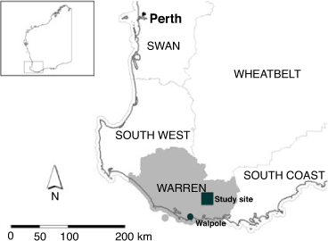
The prescribed mosaic trial was carried out in London forest (London block) ~40 km north-east of the town of Walpole in south-west Western Australia (Fig. 1). The region experiences a Mediterranean-type climate with an average annual rainfall of ~1100 mm. London block (~4800 ha) comprises three broad vegetation complexes as mapped and described by Mattiske and Havel (1998). Two of these are various forms of upland eucalypt forests and woodlands with a low closed understorey. The third complex occurs on flat, poorly drained soils and comprises sedge and heath vegetation (Fig. 2). For the purpose of this trial, these vegetation assemblages were categorised as either ‘forest’ or ‘heath’ fuel. Being structurally different, they have different fuel properties. Mature forest fuels comprise a continuous ground (surface) layer of dead leaves, twigs and bark, and an elevated fuel layer of scattered (30–60% cover) live shrubs, whereas mature heath fuels comprise a dense cover (70–100% cover) of elevated live shrubs to 1.5–2 m with suspended dead leaves and twigs. This mosaic of forests, heaths and sedgelands typifies the regional vegetation pattern.
|

|
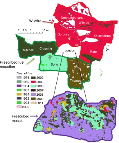
The trial area had experienced low intensity fuel reduction burns at 6–9 year intervals since the early 1970s (DBCA 2021), and the current trial commenced with a routine fuel reduction burn (Burrows and McCaw 2013) in London block in spring 2002. For comparison, and to further understand factors affecting the characteristics of fire mosaics, two other fire treatments were examined. These were recent routine fuel reduction burns carried out in forest blocks on the southern and eastern boundaries of London block, and an intense bushfire that burnt into the northern and eastern boundaries of London block in autumn 2003 (Fig. 3). Routine fuel reduction burning and prescribed mosaic burning were carried out under mild weather conditions in spring, early summer or autumn, whereas the bushfire occurred under hot, dry conditions in early autumn (Table 1).
|

|
The prescribed mosaic treatment applied to London block was achieved by a regime of frequent introduction of fire by ground (hand) and aerial ignition as summarised in Table 2. The procedure was to first establish a ~50 m wide burnt buffer around the inside perimeter of the block before each aerial ignition to reduce the risk of fire escape. This was followed by aerial (helicopter) ignition under prescribed conditions of weather, fuel moisture and lighting pattern (Table 2). Incendiaries were delivered on a 300 m (distance between flight lines) × 200 m (distance between incendiaries along the flight line) grid resulting in hundreds of small, point source slow moving fires. Under mild weather conditions, a proportion of the fires did not spread, being stopped by patches of low fuel or areas of high fuel moisture. The first introduction of fire as part of this trial was a routine fuel reduction prescribed burn done in spring 2002. To take advantage of the post-burn patchy low fuel conditions that would moderate and interrupt fire spread, follow-up introductions of fire by ground and aerial ignition occurred every 1–3 years thereafter until 2008, with the expectation that maintaining much of the landscape in a patchy low fuel age condition, fires would be low intensity, small and patchy. Estimates of fire behaviour were made at irregular intervals by ground and aerial observers who timed head fire travel distance between objects of known distance apart. Because of the spatial and temporal variability of the behaviour of the numerous small fires resulting from aerial ignition, mean fire behaviour was represented post hoc by calculations using the Dry Eucalypt Forest Fire Model (DFFM) (Gould et al. 2011) and local weather and fuel conditions. Weather data were provided by an automatic weather station (AWS) (Environdata WeatherMaster 2000) located in an open area on the western boundary of London block. Estimates of fire behaviour for the 2002 prescribed fuel reduction burn and the 2003 bushfire, which preceded the establishment of the on-site AWS, were made post hoc using DFFM and weather data from the nearest weather station (Rocky Gully ~25 km north of the area). The 2003 bushfire burnt sections of the northern boundary of London block before self-extinguishing in low fuels, and spot fires (embers from the bushfire) burnt small patches inside the block. As summarised in Table 2, multiple ignitions were attempted throughout the 2005/06 fire season. With the exception of a few small patches that burnt, the ‘young’, light fuels resulting from the 2002 prescribed burn would not sustain fire spread under mild spring burning conditions in 2005, so fire was introduced again under warmer, drier conditions in summer 2006.

|
Mapping burnt patches
Following each ignition event in London block, burn severity was classified from 30 m resolution LANDSAT 5 and LANDSAT 7 TM data to detect changes in vegetation structure by fire. LANDSAT imagery and the Differenced Normalized Burn Ratio (dNBR) were used to map the block according to burn severity classes. Five classes were used for burn severity and for potentially mapping a burn severity and fire age mosaic. A relative measure of burn severity was determined by measuring pre- and post-burn differences in the cover of live green (photosynthetically active) vegetation soon after each fire and then assigning this to one of five classes: (i) no change (unburnt); (ii) >0 ≤ 25% change (burnt); (iii) >25% ≤ 50% change (burnt); (iv) >50% ≤ 75% change (burnt); and (v) >75% change (burnt). For the purpose of mapping fire age, a binary approach to the interpretation of dNBR was used in the analysis and results reported here; burnt or unburnt following each ignition event. Class (i) was categorised as ‘unburnt’ and classes (ii), (iii), (iv) and (v) were catagorised as ‘burnt’. The same method was used to classify burn severity in the other fire treatments shown in Table 1. Burn severity is the extent of estimated biomass loss (Keeley 2009) using the methodology described by Wardell-Johnson et al. (2006). Although the method is commonly used to classify burn severity in forest fires (e.g. Cocke et al. 2005; Miller and Thode 2007), our interest was in classifying and mapping only burnt and unburnt patches. The accuracy and resolution of the satellite-derived burn severity mapping was evaluated by ground survey along a 3 km line transect in forest in London block following the 2006 ignition event. This amounted to walking the transect and using a Global Positioning System (GPS) to plot the location of each fire boundary, then comparing this with the satellite-derived map of fire boundaries along the same transect. Satellite mapping accurately detected 86% of fire boundaries detected by ground survey, but small burnt patches (<~0.16 ha) and patches burnt by very low intensity fire (flame heights <~0.15 m as determined from defoliation height) were often not detected by satellite. There is an interaction between vegetation height and openness and scorch height, which affects scorched or consumed vegetation visibility (Miller and Thode 2007). For low severity fires in tall vegetation such as forests, it is harder to define burn boundaries so we used patch areas ≥0.25 ha in the analysis. A chronosequence of satellite imagery, and fire history records maintained by the Parks and Wildlife Service of the Department of Biodiversity, Conservation and Attractions (DBCA) were used to determine the age of older patches in the fire mosaic treatment, and to reconstruct the fire histories of blocks in the prescribed fuel reduction treatment (from 1972 to 2009) and the bushfire treatment (from 1972 to 2003).
Metrics used to describe and compare fire mosaics
Burnt patches, the landscape unit of interest in this trial, are discrete mappable patches that form a spatial pattern, or a patch mosaic. Adequately describing the size (area, perimeter), seral stage (time since fire) and spatial arrangement of the fire-induced patch mosaic is important for understanding the condition of vegetation and the weather and fire history that gave rise to this condition, for comparing landscapes with different fire histories, and for interpreting ecological responses. FRAGSTATS (McGarigal and Marks 1995) has the potential to generate a plethora of metrics to characterise landscape patch structure (Cushman et al. 2008; Wang et al. 2014). McGarigal and Marks (1995) recognise two broad metric categories for describing patch mosaics: metrics that describe the composition of the patches (measures of abundance, richness, evenness (of size) and diversity) and those that describe their spatial configuration (size, perimeter, shape and connectedness). Spatial arrangement of patches (patch size, shape or perimeter-to-area ratio, patch connectedness, patch density and edge/perimeter density) has been shown to be useful for studying and understanding species conservation and ecological processes (Flather and Bevis 2002; Cushman et al. 2008; Wang et al. 2014; Inkoom et al. 2018; Sitters and Di Stefano 2020).
The metrics chosen will depend on the observer’s interest. For example, in savannas, fire heterogeneity is most often expressed in terms of proportion of area burnt, and by various analyses of burnt patch size (Brockett 2001; Russell-Smith and Yates 2007). For the current study, we chose metrics likely to reflect vegetation structure, fuel characteristics, habitat diversity and the extent of connectivity of patches, which is important for dispersal and recolonisation by some fauna (Baguette et al. 2012; Sitters et al. 2015; Vasudev et al. 2015; Pianka 2017; Parkins et al. 2018; Delaney et al. 2021). Metrics chosen to describe the scale and spatial arrangement of patches in the current study were the following: mean and maximum patch size, Euclidean distance to nearest neighbour (a measure of patch separation), patch density (number of patches per unit area) and perimeter density (length of patch perimeter, or edge, per unit area). Metrics chosen to describe the composition of the patches were the following: seral stage density (number of seral stages per unit area), patch perimeter-to-area ratio (a measure of patch shape) and measures of patch abundance, richness, evenness and size class diversity, including Margelef patch size diversity index, Shannon patch size class distribution diversity index and Pielou’s evenness index. The latter is normally used to measure species diversity and abundance, and ranges from 0 (no evenness) to 1 (complete evenness). Here, each patch was considered a ‘species’ and its ‘abundance’ was regarded as the patch area. These properties are ecologically important because animal and plant species differ in their ability to disperse between patches, can be sensitive to the permeability of patch boundaries, and can have particular requirements for habitat quality, size and configuration (Doherty and Driscoll 2018; Gardiner et al. 2018; Parkins et al. 2018). Mean values for patch area, patch density and (Euclidean) distance to nearest neighbour were calculated for each treatment, and Pielou’s evenness index, Margalef richness index and Shannon diversity index were calculated using the same data (Margalef 1958; Vranken et al. 2015) and using the Primer 6 DIVERSE function. To visually illustrate differences between treatments and the effects of variables describing scale and arrangement of patches, a Principal Coordinates Ordination (PCO) (Torgerson 1958; Gower 1966) was performed in Primer 6 using mean patch size, mean patch perimeter-to-area ratio, patch density and mean Euclidean distance to nearest neighbour as descriptor variables for each of the burn types.
Metric values for patches were calculated using raster analysis in FRAGSTATS 4.2.1.603 and ArcMap 10.3.1 (McGarigal et al. 2012; ESRI 2014) from satellite burn severity mapping data. Rasterisation of historical fire scar data was implemented using the ‘Polygon to Raster (Conversion)’ tool under ArcMap 10.3.1, while patch analysis was performed using FRAGSTATS 4.2.1.603. To analyse the data in FRAGSTATS, it was necessary to make some assumptions, including:
-
Accounting for edge effect: We chose to implement a constant edge distance of 50 m. This metric specifies the distance from any part of the fire perimeter that an area must be to be considered a ‘core area’.
-
Patch borders with no data and avoiding the truncation effect: When running this analysis, we chose to have FRAGSTATS treat fire perimeters with borders created by areas of ‘no data’, such as at the boundaries of the treatments, the same as borders created by the meeting of two different fire perimeters. We assumed that the fire perimeters present in the data represent the entire extent of the given fire’s perimeter, and that no section of any fire perimeter was lost due to the absence of data. Other than at treatment boundaries, areas of ‘no data’ were most prominent in the bushfire ‘treatment’ area and where likely areas were affected by cloud cover at the time the post-fire satellite imagery was captured, or non-flammable features such as roads, gravel pits and rock outcrops.
Factors regulating fire patchiness
Although it is known that fire patchiness (for a given fuel type) is primarily a function of factors that affect fire behaviour, including conditions of fuel, weather, topography and natural barriers to fire spread, the relationship between patchiness and these factors is poorly understood (Gill et al. 2003; Heemstra 2007; Penman et al. 2007; Inkoom et al. 2018). The McArthur Forest Fire Danger Index (FFDI) (McArthur 1967) is used in Australia to forecast the influence of weather and fuel on fire behaviour. It uses a ‘drought factor’ (time since rain) as a surrogate for fuel availability, and temperature, relative humidity and wind speed to derive a numerical Forest Fire Danger Index and a categorical Forest Fire Danger Rating – the higher the index, the more severe the potential fire behaviour. In south-west Australian forests, fire behaviour is also affected by fuel structure and load, which are a function of time since fire (McCaw et al. 2002; Gould et al. 2011). Therefore, we explored the relationship between patch size diversity indices (Margalef and Shannon) as the dependent variables, and FFDI, ignition frequency and fuel age (or time since last fire) as independent variables. The ignition frequency for the prescribed mosaic treatment was for the period 2002–2008, being the times of the first and last ignitions as part of this trial. The ignition frequencies for the prescribed fuel reduction burn and bushfire treatments were the mean ignition frequency of the blocks in each treatment over the period 1972–2009 (2009 being the year of the last prescribed fuel reduction burn) and 1972–2003 (2003 being the year of the bushfire) respectively (Table 1). Including these treatments in the analysis provided a greater range of data to explore factors that affect spatial and temporal scales of fire mosaics. A distance-based linear models approach using the DISTLM function in Primer 6 (Anderson et al. 2008) was applied to determine the relationship between ignition frequency and variation in the similarity matrix comparing the three fire regimes as described by mean patch size, patch density, perimeter-to-area ratio and patch connectedness. A separate DISTLM was used to determine the relationship between FFDI and variation in the similarity matrix. Separate analyses were used because of the limited number of treatments as samples.
Results
The time since fire (year last burnt) mosaics (as at 2011, 3 years after the last ignition event in London block), and for the three treatments are shown graphically in Fig. 3. The prescribed fuel reduction burn treatment is similar in total area to the unplanned bushfire treatment, although the blocks were burnt in separate ignition events, whereas in the bushfire treatment, the blocks were burnt in a single ignition event. Within the prescribed mosaic treatment, the forest vegetation exhibited greater patchiness than the heath vegetation. The largest burnt patch in heath fuel was 2275 ha compared with the largest patch in forest fuel of 478 ha. Table 3 shows the proportion of London block burnt by broad fuel type at each ignition event. There were about equal proportions (by area) of heath and forest vegetation in London block, and during the 2002 routine prescribed fuel reduction burn, similar amounts of each were burnt. However, in the 2008 ignition event, the area of heath that burnt was almost twice that of forest. Of the 55% of London block that burnt in 2008, 37% was heath and 18% was forest; of the area of heath, 72% was burnt compared with 38% of the forest area (Table 3).

|
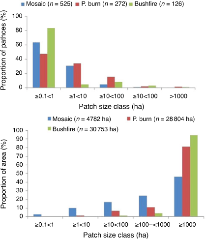
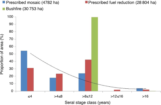
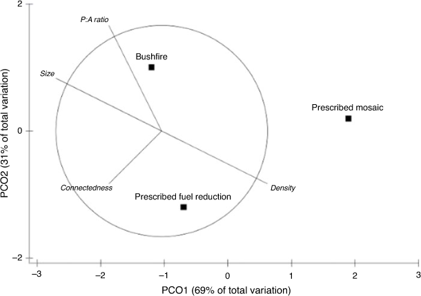
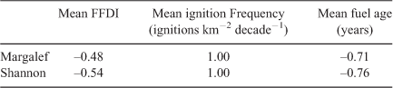
A summary of measures of the configuration and composition of patches for each fire treatment is in Table 4. The prescribed mosaic had significantly higher measures of patch density, diversity and perimeter density (edge) and significantly lower measures of mean and maximum patch size, than the other treatments. The prescribed mosaic also had the highest seral diversity and patch size diversity. Patch separation, or the mean distance between patch centroids, was lowest for the prescribed mosaic and highest for the fuel reduction burn. In all treatments, small patches <1 ha were the most numerous, making up 60–80% of all patches, but they contributed little to the total area (Fig. 4). For the prescribed fuel reduction burn and bushfire treatments, 81% and 95% respectively was burnt by patches >1000 ha, contrasting with the prescribed mosaic treatment where 47% of the area was burnt by a single patch >1000 ha. For the prescribed mosaic, the shape of the distribution of time since fire classes (seral stages) as a proportion of the treatment area approximates a negative exponential (Fig. 5). The seral stage class distribution for the prescribed fuel reduction burn treatment was more uniform across the classes, whereas 99.7% of the area of the bushfire treatment was in a single class (Fig. 5). As at 2011, older seral stages (>12 years since fire) made up ~4% of the area of the prescribed mosaic and prescribed fuel reduction burn treatments but only ~0.3% of the bushfire treatment. PCO of the Euclidean distance between fire treatments and according to patch size, patch density, patch area-to perimeter ratio and patch separation is shown in Fig. 6. The three treatments show a high degree of separation. Location of the bushfire treatment on the ordination is mostly associated with larger patch size, whereas the prescribed mosaic is associated with high patch density and perimeter-to-area ratio, and smaller Euclidean distance to nearest neighbour. Patch size diversity indices (Margalef and Shannon) were inversely related to the FFDI and fuel age and directly related to ignition frequency, meaning fires were patchier when the FFDI and fuel age were low and the ignition frequency was high (Table 5).

|
|
|
|
|
DISTLM analysis indicated that ignition frequency explained 69% of variation in the similarity matrix comparing the three fire treatments as described by mean patch size, patch density, perimeter-to-area ratio and patch connectedness. A separate DISTLM analysis indicated that FFDI explained 44% of variation in the similarity matrix.
Discussion
Landscape ignition (fire) frequency and weather conditions as represented by the FFDI had the greatest influence on the scale, distribution and diversity of the fire mosaic in south-west Australia landscapes. Over a 10-year period, the introduction of fire every 1–3 years under low to moderate FFDI conditions resulted in a landscape comprising significantly smaller burnt patches, greater evenness in patch size class distribution and higher seral diversity than landscapes burnt every 6–9 years for fuel reduction or a landscape burnt by intense bushfire. Mosaic burning also resulted in greater patch density, perimeter density and patch connectedness.
In broad terms and for a given vegetation (fuel) type, patchiness of a fire event, expressed either as burnt or unburnt patches or as burn severity, will largely depend upon weather conditions and fuel flammability. Apart from areas naturally devoid of fuel, computer simulations and empirical evidence in biomes such as boreal forests and grassland savannas have shown that, in addition to weather and topographical conditions, fire history is important in determining the spatial arrangement of fuel structure, load and continuity, so is an important influence on the future fire mosaic (e.g. Turner and Dale 1990; Miller and Urban 2000; Slocum et al. 2003; Parks et al. 2012; Caillault et al. 2020; San Miguel et al. 2020). Working in eucalypt forests of south-east Australia, Heemstra (2007) recognised two types of fire patchiness: patches that did not burn because they were not flammable at the time of the fire, and patches that did not burn because the fire did not reach them. Fuels will not burn if they are too moist or too light and discontinuous to sustain fire spread under the prevailing weather (FFDI) conditions. In the current study, frequent introduction of fire every 1–3 years created and maintained patches of low fuel areas dispersed throughout the landscape, which interrupted the spread of fire in subsequent ignitions. Through time, under mild weather conditions, this resulted in a reduction in burnt patch size and an increase in seral diversity because fires were unable to spread to all parts of the landscape. In addition to fuel continuity linked with ignition frequency, the current trial demonstrated that weather conditions as reflected by the FFDI and fuel age (time since last fire) also influenced the level of heterogeneity, or patchiness, of the fire mosaics in the three treatments examined. In eucalypt forests, fuel age is a surrogate for fuel flammability, as older fuels are heavier and structurally more flammable than younger fuels (Gould et al. 2011). The FFDI and fuel age were inversely related to patchiness, as exemplified by the high intensity dry season bushfire that burnt 99.7% of the treatment area. It is generally understood, in qualitative terms, that low intensity, slow spreading fires burning in moist landscapes are patchier because slight changes in weather conditions (such as wind speed) or fuel flammability (such as fuel moisture or fuel continuity) can stop fire spreading (Atkins and Hobbs 1995; Slocum et al. 2003; Knapp and Keeley 2006; Heemstra 2007; Penman et al. 2007). Flank fires and back fires are much lower intensity than head fires, so areas burnt by these fires would be expected to be patchier than areas burnt by head fires. We were not able to measure this in the current trial. In northern Australian savannas, early low intensity dry season fires burning under conditions of low to moderate Grassland Fire Danger Indices (GFDI) were more patchy than higher intensity dry season fires burning on high GFDIs (Gill et al. 2003; Price et al. 2003; Russell-Smith and Yates 2007).
The prescribed mosaic and prescribed fuel reduction burn treatments were conducted under similar low FFDI conditions (Table 4) but resulted in significantly different levels of patchiness because they varied significantly in fire history (ignition frequency) and therefore fuel age composition. The high ignition frequency experienced by the prescribed mosaic treatment resulted in a larger proportion of the landscape with patches of younger, discontinuous, less flammable fuels that slowed or stopped fire spread under conditions of low FFDI. This resulted in smaller, patchier fires, an observation that has been reported for other vegetation types (Rocca 2009). Lower ignition frequencies experienced by the prescribed fuel reduction burn and bushfire treatments resulted in a higher proportion of older, heavier and more flammable fuel structures that enabled the development of larger, and in the case of the bushfire treatment, more intense fires.
The prescribed fuel reduction treatment had mosaic outcomes intermediate between the bushfire and the prescribed mosaic treatments for most metrics. Surprisingly, an exception was patch separation, which was highest in the prescribed fuel reduction burn treatment, not the bushfire treatment (Table 4). This is presumably because patches within a bushfire are small and clumpy within the main burnt area and distances to the enclosing boundary of the last fire are not considered (Hargis et al. 1998). On the other hand, the prescribed mosaic had a high Pielou index and a low patch separation value, suggesting patches are more evenly distributed in size and more abundant within the mosaic. Landscapes with patches resulting from low frequency high impact disturbance, such as the bushfire treatment, can produce similar patch separation values as landscapes with high frequency, low impact disturbances, such as the prescribed mosaic treatment, because the distance between aggregated patches can be similar (Hargis et al. 1998).
Although not included in the measure of patchiness, the bushfire treatment experienced a substantially higher fire intensity than the mosaic and prescribed burn treatments (Table 2), resulting in complete defoliation of the vegetation over large areas. Limited by the spatial resolution of Landsat 5 and 7 imagery, we restricted our analysis to patches ≥ 0.25 ha, but the ground survey showed that fire patchiness in the mosaic treatment was higher than that measured using satellite imagery, which is consistent with other studies (Price et al. 2003; Cocke et al. 2005). Detection of smaller patches will increase with higher resolution remote sensing capability, thereby increasing the overall level of measurable patchiness. Small patches, while large in number, made up a small proportion of the area of the treatments (<1%), which is also consistent with other studies (Russell-Smith and Yates 2007; Smith et al. 2007). However, they may be ecologically important.
While we focussed on patchiness at the landscape scale, integrating all vegetation types in the landscape, the trial revealed that under conditions of low to moderate FFDI, vegetation/fuel type can also influence fire patchiness. In the prescribed mosaic treatment, the highest level of patchiness was achieved in younger forest fuels (3–4 years since last fire) that comprised a shallow but continuous layer of dead leaves and twigs on the forest floor, with fuel moisture content being the only constraint to fire spread. Under conditions of low FFDI, these light fuels burnt at a low intensity and patchily. However, under conditions of low FFDI, the so-called ‘go-no go’ heath fuel, comprising elevated live and dead vegetation, was reluctant to sustain fire spread until about 6 years after fire when there was a sufficiently high proportion of elevated dead fuel. Once threshold fuel and weather conditions for fire spread were exceeded, head fire rate of spread in heath was 2–3 times greater than in forests; combustion was more complete and so less patchy. In the 2008 ignition event in London block, 72% of the area that burnt was heath fuel, leading to an over representation of this age class in the mosaic. Other workers have also reported the influence of vegetation type, especially its structure and moisture content, on fire patchiness (e.g. Slocum et al. 2003; Oliveira et al. 2015). The effect of fuel type on patchiness for given conditions of fuel age and FFDI requires further investigation.
When implementing prescribed fires at 6–9 year intervals for fuel hazard reduction in spring, the objective is to create an unspecified level of fire patchiness by burning under conditions such that the upland forest surface litter fuels are dry but fuels in the lower lying parts of the landscape, such as riparian zones, gullies and some wetland/organic substrate ecosystems, are moist and will not burn. Although this is desirable, it is not always achievable because of the risk of delayed ignition of these areas as they dry with the onset of summer. In the absence of post-burn rainfall sufficient to completely extinguish a spring prescribed burn, ‘hot spots’ in the landscape can ignite unburnt fuels as they dry. Re-ignition of spring prescribed burns later in the season is particularly prevalent in long unburnt fuels with a deep forest floor litter fuel bed. During early spring prescribed burns, the top layer of the litter fuel bed (surface fuel) is dry and flammable, but deeper litter fuel near the soil surface is often too moist to burn by flaming combustion and, in the absence of substantial rainfall, can smoulder for some time after a prescribed burn. As the drying season progresses, this fuel dries and ignites as flaming combustion, resulting in the combustion of riparian zones, organic substrates and other hitherto unburnt areas. The re-ignition of unburnt areas and subsequent loss of patchiness has been exacerbated in recent decades by climate variability, which in south-west Australia has resulted in lower winter and spring rainfall (Bates et al. 2008) and a higher risk of ‘hot spots’ such as smouldering logs, persisting in the post-prescribed burn landscape. This could be overcome to some extent by burning earlier in the season, or as demonstrated here, by increasing the landscape ignition frequency.
There is ample historical evidence that before European colonisation, Noongar Aboriginal people used fire purposefully, extensively and frequently in south-west Australia for a variety of reasons (Hallam 1975; Hallam 2002; Abbott 2003; Lullfitz et al. 2017). Although the spatial and temporal scales of the pre-historic fire mosaic are unknown, it’s possible that frequent burning of these landscapes by Aboriginal people over thousands of years may have resulted in a similar mosaic to that reported here. Following recent catastrophic bushfires in south-east Australia, there has been renewed interest in reinstating traditional Aboriginal fire management practices to mitigate bushfire impacts on communities and the environment (e.g. Smith et al. 2021). Where fire management on public land aims to create fine-scale fire mosaics, we see benefit in engaging traditional owners and incorporating their traditional fire management practices to achieve a range of conservation, community protection, social and cultural outcomes.
Conclusions
This operational trial demonstrated that the metrics of forest fire mosaics, including diversity of seral stages (fuel ages), patch size, patch density, length of habitat or fire age boundary, patch distribution and patch connectedness can be managed to a large extent by ignition frequency and the timing of the introduction of fire with respect to season and surface burning conditions as reflected by the FFDI. Over 10 years, the frequent introduction of fire under low to moderate FFDIs resulted in a landscape comprising a higher diversity of seral stages and a higher density of smaller patches compared with an area treated by routine fuel reduction prescribed burns. Fire patchiness was greatest in forest vegetation with surface litter fuel, and it was more difficult to achieve patchiness in the heath vegetation because of its structure as a fuel. A high intensity bushfire in the region resulted in little patchiness, very large areas of the same seral stage, and large areas of defoliated forest. Attempting to create patchiness in prescribed burns by utilising seasonal moisture differentials is becoming increasingly difficult and risky in a climate that is trending warmer and drier. The frequent and targeted introduction of fire under mild early spring or late autumn weather conditions provides an opportunity to create a fine-scale fire mosaic and to protect fire sensitive habitats such as riparian zones, peat swamps and rock outcrops from frequent fire by surrounding them with light, patchy fuels that will not sustain high intensity fire. Fire management on public lands that aims to create fine-scale mosaics also presents an opportunity to meaningfully engage Aboriginal people, incorporating them and their traditional fire knowledge, to deliver a range of environmental, social and economic benefits.
Data availability statement
Data used to generate the results of this trial are available from Allan Wills (coauthor).
Conflicts of interest
The authors declare no conflicts of interest.
Declaration of funding
This research did not receive any specific funding.
Acknowledgements
We thank the fire operations staff and conservation employees at the Department of Biodiversity, Conservation and Attractions (DBCA) Franklin District (Walpole), who willingly participated in this trial by implementing the prescribed mosaic burning program. We also thank Dr Li Shu (formerly of the Fire Management Branch, Department of Parks and Wildlife) for satellite mapping of burnt patches.
References
Abbott I (2003) Aboriginal fire regimes in south-west Western Australia. Evidence from historical documents. In ‘Fire in ecosystems of south-west Western Australia: impacts and management’. (Eds I AbbottI, N Burrows) pp. 119–146. (Backhuys: Leiden, The Netherlands)Anderson MJ, Gorley RN, Clarke KR (2008) ‘PERMANOVA+ for PRIMER: Guide to Software and Statistical Methods.’ (PRIMER-E: Plymouth, UK)
Atkins L, Hobbs RJ (1995) Measurement and effects of fire heterogeneity in south-west Australian wheatbelt vegetation. CALMscience 4, 67–76.
Baguette M, Legrans D, Freville H, Van Dyck H, Ducatez S (2012) Evolutionary ecology of dispersal in fragmented landscape. In ‘Dispersal ecology and evolution’. (Eds J Clobert, M Baguette, T Benton, J Bullock) pp. 381–389. (Oxford University Press)
Bates BC, Hope P, Ryan B, Smith I, Charles S (2008) Key findings from the Indian Ocean Climate Initiative and their impact on policy development in Australia. Climatic Change 89, 339–354.
| Key findings from the Indian Ocean Climate Initiative and their impact on policy development in Australia.Crossref | GoogleScholarGoogle Scholar |
Bliege Bird R, Bird DW, Codding BF, Parker CH, Jones JH (2008) The ‘fire stick farming’ hypothesis: Australian Aboriginal foraging strategies, biodiversity, and anthropogenic fire mosaics. Proceedings of the National Academy of Sciences of the United States of America 105, 14796–14801.
| The ‘fire stick farming’ hypothesis: Australian Aboriginal foraging strategies, biodiversity, and anthropogenic fire mosaics.Crossref | GoogleScholarGoogle Scholar | 18809925PubMed |
Bradstock R, Bedward M, Gill AM, Cohn JS (2005) Which mosaic? A landscape ecological approach for evaluating interactions between fire regimes, habitat and animals. Wildlife Research 32, 409–423.
| Which mosaic? A landscape ecological approach for evaluating interactions between fire regimes, habitat and animals.Crossref | GoogleScholarGoogle Scholar |
Brockett BH (2001). Implementing a patch-mosaic burning system in southern African savanna conservation areas. Master’s thesis, University of Cape Town, South Africa.
Brockett BH, Biggs HC, van Wilgen BW (2001) A patch mosaic burning system for conservation areas in southern African savannas. International Journal of Wildland Fire 10, 169–183.
| A patch mosaic burning system for conservation areas in southern African savannas.Crossref | GoogleScholarGoogle Scholar |
Burrows N, McCaw L (2013) Prescribed burning in southwestern Australian forests. Frontiers in Ecology and the Environment 11, e25–e34.
| Prescribed burning in southwestern Australian forests.Crossref | GoogleScholarGoogle Scholar |
Burrows ND, Ward B, Robinson AD (1995) Jarrah forest fire history from stem analysis and anthropological evidence. Australian Forestry 58, 7–16.
| Jarrah forest fire history from stem analysis and anthropological evidence.Crossref | GoogleScholarGoogle Scholar |
Byram GM (1959) Combustion of forest fuels. In ‘Forest fire: control and use’. (Ed. KP Davis) pp. 61–89. (McGraw-Hill: New York, NY).
Caillault S, Laris P, Fleurant P, Delahaye D, Ballouche A (2020) Anthropogenic fires in West African landscapes: A spatially explicit model perspective of humanized savannas. Fire (Basel, Switzerland) 3, 62
| Anthropogenic fires in West African landscapes: A spatially explicit model perspective of humanized savannas.Crossref | GoogleScholarGoogle Scholar |
Clarke MF (2008) Catering for the needs of fauna in fire management: science or just wishful thinking? Wildlife Research 35, 385–394.
| Catering for the needs of fauna in fire management: science or just wishful thinking?Crossref | GoogleScholarGoogle Scholar |
Cocke AE, Fule PZ, Crouse JE (2005) Comparison of burn severity assessments using Differenced Normalized Burn Ratio and ground data. International Journal of Wildland Fire 14, 189–198.
| Comparison of burn severity assessments using Differenced Normalized Burn Ratio and ground data.Crossref | GoogleScholarGoogle Scholar |
Coops NC, Catling PC (2000) Estimating forest habitat complexity in relation to time since fire. Austral Ecology 25, 344–351.
| Estimating forest habitat complexity in relation to time since fire.Crossref | GoogleScholarGoogle Scholar |
Cushman SA, McGarigal K, Neel MC (2008) Parsimony in landscape metrics; strength, universality and consistency. Ecological Indicators 8, 691–703.
| Parsimony in landscape metrics; strength, universality and consistency.Crossref | GoogleScholarGoogle Scholar |
Delaney L, Di Stefano J, Sitters H (2021) Mammal responses to spatial pattern in fire history depend on landscape context. Landscape Ecology 36, 897–914.
| Mammal responses to spatial pattern in fire history depend on landscape context.Crossref | GoogleScholarGoogle Scholar |
Department of Biodiversity, Conservation and Attractions (DBCA) (2021) DBCA Fire history (DBCA-060). Available at https://catalogue.data.wa.gov.au/dataset/dbca-fire-history
Doherty TS, Driscoll DA (2018) Coupling movement and landscape ecology for animal conservation in production landscapes. Proceedings. Biological Sciences 285, 20172272
| Coupling movement and landscape ecology for animal conservation in production landscapes.Crossref | GoogleScholarGoogle Scholar | 29298935PubMed |
Driscoll DA, Lindenmayer DB, Bennett AF, Bode M, Bradstock RA, Cary GJ, et al. (2010) Resolving conflicts in fire management using decision theory: asset-protection versus biodiversity conservation. Conservation Letters 3, 215–223.
| Resolving conflicts in fire management using decision theory: asset-protection versus biodiversity conservation.Crossref | GoogleScholarGoogle Scholar |
ESRI (2014) ‘ArcMap version 10.3.1.’ (Environmental Systems Research Institute: Redlands, CA)
Flather CH, Bevis M (2002) Patchy reaction-diffusion and population abundance. The relative importance of habitat amount and arrangement. American Naturalist 159, 40–56.
| Patchy reaction-diffusion and population abundance. The relative importance of habitat amount and arrangement.Crossref | GoogleScholarGoogle Scholar |
Gardiner R, Bain G, Hamer R, Jones ME, Johnson CN (2018) Habitat amount and quality, not patch size, determine persistence of a woodland-dependent mammal in an agricultural landscape. Landscape Ecology 33, 1837–1849.
| Habitat amount and quality, not patch size, determine persistence of a woodland-dependent mammal in an agricultural landscape.Crossref | GoogleScholarGoogle Scholar |
Gill AM, Allan G, Yates C (2003) Fire-created patchiness in Australian savannas. International Journal of Wildland Fire 12, 323–331.
| Fire-created patchiness in Australian savannas.Crossref | GoogleScholarGoogle Scholar |
Gould JS, McCaw WL, Cheney NP (2011) Quantifying fine fuel dynamics and structure in dry eucalypt forest (Eucalyptus marginata) in Western Australia. Forest Ecology and Management 262, 531–546.
| Quantifying fine fuel dynamics and structure in dry eucalypt forest (Eucalyptus marginata) in Western Australia.Crossref | GoogleScholarGoogle Scholar |
Gower JC (1966) Some distance properties of latent root and vector methods used in multivariate analysis. Biometrika 53, 325–338.
| Some distance properties of latent root and vector methods used in multivariate analysis.Crossref | GoogleScholarGoogle Scholar |
Hallam SJ (1975) ‘Fire and hearth: a study of Aboriginal usage and European usurpation in south-western Australia’. (Australian Institute of Aboriginal Studies: Canberra)
Hallam S (2002) Peopled landscapes in southwestern Australia in the early 1800s: Aboriginal burning off in the light of historical documents. Journal of the Royal Western Australian Historical Society 12, 177–191.
Hargis CD, Bissonette JA, David JL (1998) The behavior of landscape metrics commonly used in the study of habitat fragmentation. Landscape Ecology 13, 167–186.
| The behavior of landscape metrics commonly used in the study of habitat fragmentation.Crossref | GoogleScholarGoogle Scholar |
Heemstra S (2007) Bushfire patchiness. PhD thesis, School of Earth and Environmental Sciences, University of Woollongong, NSW, Australia.
Hobbs RJ, Atkins L (1988) Spatial variability of experimental fires in south-west Australia. Australian Journal of Ecology 13, 295–299.
| Spatial variability of experimental fires in south-west Australia.Crossref | GoogleScholarGoogle Scholar |
Inkoom JN, Frank S, Greve K, Walz U, Furst C (2018) Suitability of different landscape metrics for the assessment of patchy landscapes in West Africa. Ecological Indicators 85, 117–127.
| Suitability of different landscape metrics for the assessment of patchy landscapes in West Africa.Crossref | GoogleScholarGoogle Scholar |
Jones GM, Tingley MW (2021) Pyrodiversity and biodiversity: A history, synthesis, and outlook. Diversity and Distributions
| Pyrodiversity and biodiversity: A history, synthesis, and outlook.Crossref | GoogleScholarGoogle Scholar |
Keeley J (2009) Fire intensity, fire severity and burn severity: a brief review and suggested usage. International Journal of Wildland Fire 18, 116–126.
| Fire intensity, fire severity and burn severity: a brief review and suggested usage.Crossref | GoogleScholarGoogle Scholar |
Kelly LT, Nimmo DG, Spence-Bailey LM, Taylor RS, Watson SJ, Clarke MF, Bennet AF (2012) Managing fire mosaics for small mammal conservation: a landscape perspective. Journal of Applied Ecology 49, 412–421.
| Managing fire mosaics for small mammal conservation: a landscape perspective.Crossref | GoogleScholarGoogle Scholar |
Knapp EE, Keeley JE (2006) Heterogeneity in fire severity within early season and late season prescribed burns in a mixed conifer forest. International Journal of Wildland Fire 15, 37–45.
| Heterogeneity in fire severity within early season and late season prescribed burns in a mixed conifer forest.Crossref | GoogleScholarGoogle Scholar |
Laris P (2002) Burning the seasonal mosaic: Preventative burning strategies in the wooded savanna of southern Mali. Human Ecology 30, 155–186.
| Burning the seasonal mosaic: Preventative burning strategies in the wooded savanna of southern Mali.Crossref | GoogleScholarGoogle Scholar |
Letnic M (2001) Long distance movements and use of fire mosaics by small mammals in the Simpson Desert, central Australia. Australian Mammalogy 23, 125–134.
| Long distance movements and use of fire mosaics by small mammals in the Simpson Desert, central Australia.Crossref | GoogleScholarGoogle Scholar |
Lindenmayer DB, Margules CR, Botkin DB (2000) Indicators of biodiversity for ecologically sustainable forest management. Conservation Biology 14, 941–950.
| Indicators of biodiversity for ecologically sustainable forest management.Crossref | GoogleScholarGoogle Scholar |
Lullfitz A, Dortch J, Hopper SD, Pettersen C, Reynolds R, Guilfoyle D (2017) Human niche construction: Noongar evidence in pre-colonial south west Australia. Conservation & Society 15, 201–216.
| Human niche construction: Noongar evidence in pre-colonial south west Australia.Crossref | GoogleScholarGoogle Scholar |
Margalef R (1958) Information Theory in Ecology. General Systems 3, 36–71.
Mattiske EM, Havel JJ (1998) Regional Forest Agreement: vegetation complexes. Department of Conservation and Land Management, Perth, Western Australia.
McArthur AG (1967) Fire Behaviour in Eucalypt Forests. Department of National Development Forestry and Timber Bureau, Canberra, Leaflet 107.
McCaw WL, Neal JE, Smith RH (2002) Stand characteristics and fuel accumulation in a sequence of even-aged karri (Eucalyptus diversicolor) stands in south-west Western Australia. Forest Ecology and Management 158, 263–271.
| Stand characteristics and fuel accumulation in a sequence of even-aged karri (Eucalyptus diversicolor) stands in south-west Western Australia.Crossref | GoogleScholarGoogle Scholar |
McGarigal K, Marks BJ (1995) FRAGSTATS: spatial analysis program for quantifying landscape structure. USDA Forest Service, Pacific Northwest Research Station, General Technical Report PNW-GTR-351. (Portland, OR, USA)
McGarigal K, Cushman SA, Ene E (2012) FRAGSTATS v4: Spatial Pattern Analysis Program for Categorical and Continuous Maps. Computer software program produced by the authors at the University of Massachusetts, Amherst. Available at http://www.umass.edu/landeco/research/fragstats/fragstats.html
Miller JD, Thode AE (2007) Quantifying burn severity in a heterogeneous landscape with a relative version of the delta Normalized Burn Ratio (dNBR). Remote Sensing of Environment 109, 66–80.
| Quantifying burn severity in a heterogeneous landscape with a relative version of the delta Normalized Burn Ratio (dNBR).Crossref | GoogleScholarGoogle Scholar |
Miller C, Urban DL (2000) Connectivity of forest fuels and surface fire regimes. Landscape Ecology 15, 145–154.
| Connectivity of forest fuels and surface fire regimes.Crossref | GoogleScholarGoogle Scholar |
O’Reilly L, Ogada D, Palmer TM, Keesing F (2006) Effects of fire on bird diversity and abundance in an East African savannah. African Journal of Ecology 44, 165–170.
| Effects of fire on bird diversity and abundance in an East African savannah.Crossref | GoogleScholarGoogle Scholar |
Oliveira SLJ, Campagnolo ML, Price OF, Edwards AC, Russell-Smith J, Pereira JMC (2015) Ecological implications of fine-scale fire patchiness and severity in tropical savannas of northern Australia. Fire Ecology 11, 10–31.
| Ecological implications of fine-scale fire patchiness and severity in tropical savannas of northern Australia.Crossref | GoogleScholarGoogle Scholar |
Parkins K, York A, Di Stefano J (2018) Edge effects in fire‐prone landscapes: Ecological importance and implications for fauna. Ecology and Evolution 8, 5937–5948.
| Edge effects in fire‐prone landscapes: Ecological importance and implications for fauna.Crossref | GoogleScholarGoogle Scholar | 29938104PubMed |
Parks SA, Parisien MA, Miller C (2012) Spatial bottom-up controls on fire likelihood vary across western North America. Ecosphere 3, 1–20.
| Spatial bottom-up controls on fire likelihood vary across western North America.Crossref | GoogleScholarGoogle Scholar |
Parr CL, Andersen AN (2006) Patch mosaic burning for biodiversity conservation: a critique of the pyrodiversity paradigm. Conservation Biology 20, 1610–1619.
| Patch mosaic burning for biodiversity conservation: a critique of the pyrodiversity paradigm.Crossref | GoogleScholarGoogle Scholar | 17181796PubMed |
Penman TD, Kavanagh RP, Bins DL, Melick DR (2007) Patchiness of prescribed burns in dry sclerophyll eucalypt forests in South-eastern Australia. Forest Ecology and Management 252, 24–32.
| Patchiness of prescribed burns in dry sclerophyll eucalypt forests in South-eastern Australia.Crossref | GoogleScholarGoogle Scholar |
Pianka ER (2017) ‘Ecology and natural history of desert lizards’. (Princeton University Press: Princeton, NJ)
Price O, Russell-Smith J, Edwards A (2003) Fine-scale patchiness of different fire intensities in sandstone heath vegetation in northern Australia. International Journal of Wildland Fire 12, 227–236.
| Fine-scale patchiness of different fire intensities in sandstone heath vegetation in northern Australia.Crossref | GoogleScholarGoogle Scholar |
Rocca ME (2009) Fine scale patchiness in fuel can influence post fire understorey composition in a mixed conifer forest, Sequoia National Park, California. Natural Areas Journal 29, 126–132.
| Fine scale patchiness in fuel can influence post fire understorey composition in a mixed conifer forest, Sequoia National Park, California.Crossref | GoogleScholarGoogle Scholar |
Russell-Smith J, Yates CP (2007) Australian savanna fire regimes: Context, scales, patchiness. Fire Ecology 3, 48–63.
| Australian savanna fire regimes: Context, scales, patchiness.Crossref | GoogleScholarGoogle Scholar |
San-Miguel I, Coops NC, Raphael D, Chavardes RV, Andison DW, Pickell PD (2020) What controls fire spatial patterns? Predictability of fire characteristics in the Canadian boreal zone. Ecosphere 11, e02985
| What controls fire spatial patterns? Predictability of fire characteristics in the Canadian boreal zone.Crossref | GoogleScholarGoogle Scholar |
Sitters H, Di Stefano J (2020) Integrating functional connectivity and fire management for better conservation outcomes. Conservation Biology 34, 550–560.
| Integrating functional connectivity and fire management for better conservation outcomes.Crossref | GoogleScholarGoogle Scholar | 31777984PubMed |
Sitters H, Di Stefano J, Christie F, Sunnucks P, York A (2015) Bird diversity increases after patchy prescribed fire: implications from a before-after-control-impact study. International Journal of Wildland Fire 24, 690–701.
| Bird diversity increases after patchy prescribed fire: implications from a before-after-control-impact study.Crossref | GoogleScholarGoogle Scholar |
Slocum MG, Platt WJ, Cooley HC (2003) Effects of differences in prescribed fire regimes on intensity and patchiness of fires in subtropical savannas of Everglades national park, Florida. Restoration Ecology 11, 91–102.
| Effects of differences in prescribed fire regimes on intensity and patchiness of fires in subtropical savannas of Everglades national park, Florida.Crossref | GoogleScholarGoogle Scholar |
Smith AMS, Drake NA, Wooster MJ, Hudak AT, Holden ZA, Gibbons CJ (2007) Production of Landsat ETM+ reference imagery of burned areas within southern African savannahs: comparison of methods and application to MODIS. International Journal of Remote Sensing 28, 2753–2775.
| Production of Landsat ETM+ reference imagery of burned areas within southern African savannahs: comparison of methods and application to MODIS.Crossref | GoogleScholarGoogle Scholar |
Smith W, Neal T, Weir JK (2021) Persuasion without politics: The work of reviving Indigenous peoples’ fire management in southern Australia. Geoforum 120, 82–92.
| Persuasion without politics: The work of reviving Indigenous peoples’ fire management in southern Australia.Crossref | GoogleScholarGoogle Scholar |
Tolhurst KG, Flinn DW, Loyn RH, Wilson AG, Foletta I (1992) Ecological effects of fuel reduction burning in a dry sclerophyll forest. A summary of principal research findings and their management implications. Forest Research Centre Publication, Department of Conservation and Environment, Melbourne Victoria.
Torgerson WS (1958) ‘Theory and methods of scaling’. (John Wiley & Sons: New York, NY)
Turner MG, Dale VH (1990) Modeling landscape disturbance. In ‘Quantitative methods in landscape ecology’. (Eds MG Turner, RH Gardner) pp. 323–352. (Springer-Verlag: New York, NY)
VanWilgen BW, Bond WJ, Richardson DM (1992) The ecology of fynbos: nutrients, fire and diversity. In ‘Ecosystem management’. (Ed. RM Cowling) pp. 345–371. (Oxford University Press: Oxford)
Vasudev D, Fletcher RJ, Goswami VR (2015) From dispersal constraints to landscape connectivity: lessons from species distribution modelling. Ecography 38, 967–978.
| From dispersal constraints to landscape connectivity: lessons from species distribution modelling.Crossref | GoogleScholarGoogle Scholar |
Vranken I, Baudry J, Aubinet M, Visser M, Bogaert J (2015) A review on the use of entropy in landscape ecology: heterogeneity, unpredictability, scale dependence and their links with thermodynamics. Landscape Ecology 30, 51–65.
| A review on the use of entropy in landscape ecology: heterogeneity, unpredictability, scale dependence and their links with thermodynamics.Crossref | GoogleScholarGoogle Scholar |
Wang X, Blanchet FG, Koper N (2014) Measuring habitat fragmentation: An evaluation of landscape pattern metrics. Methods in Ecology and Evolution 5, 634–646.
| Measuring habitat fragmentation: An evaluation of landscape pattern metrics.Crossref | GoogleScholarGoogle Scholar |
Wardell-Johnson G, Burrows N, Li S (2006) Emergent patterns in the mosaic of patch burning vary with the fire environment and landscape context in south-western Australia. Bushfire Conference, 6–9 June 2006. Brisbane, Queensland, Australia. Paper No. 042: 6 pp.
Watson SJ, Taylor RS, Nimmo DG, Kelly LT, Haslem A, Clarke MF, Bennett AF (2012) Effects of time since fire on birds: How informative are generalised fire response curves for conservation management? Ecological Applications 22, 685–696.
| Effects of time since fire on birds: How informative are generalised fire response curves for conservation management?Crossref | GoogleScholarGoogle Scholar | 22611864PubMed |
Whelan RJ, Muston RM (1991) Fire regimes and management in south eastern Australia. In ‘Proceedings of the 17th Tall Timbers Fire Ecology Conference. High intensity fires in woodlands: management challenges and options’. (Ed. SM Hermann) Tall Timbers Research Station, pp. 235–258. (Tallahassee, FL, USA)
Williams JE, Whelan RJ, Gill AM (1994) Fire and environmental heterogeneity in southern temperate forest ecosystems: implications for management. Australian Journal of Botany 42, 125–131.
| Fire and environmental heterogeneity in southern temperate forest ecosystems: implications for management.Crossref | GoogleScholarGoogle Scholar |