

A multi-scale assessment of fire scar mapping in the Great Victoria Desert of Western Australia
Jaume Ruscalleda-Alvarez A B C E , Dorian Moro A D and Richard van Dongen BA Great Victoria Desert Biodiversity Trust, Perth, WA 6000, Australia.
B Department of Biodiversity, Conservation and Attractions, Kensington, WA 6151, Australia.
C School of Biological Sciences, University of Western Australia, Crawley, WA 6009, Australia.
D School of Veterinary and Life Sciences, Murdoch University, Murdoch, WA 6150, Australia.
E Corresponding author. Email: jaume.ruscalledaalvarez@gvdbiodiversitytrust.org.au
International Journal of Wildland Fire 30(11) 886-898 https://doi.org/10.1071/WF21019
Submitted: 11 February 2021 Accepted: 20 July 2021 Published: 19 August 2021
Journal Compilation © IAWF 2021 Open Access CC BY-NC-ND
Abstract
Fire management is increasingly acknowledged as a necessary tool to maintain diversity in desert environments such as the Great Victoria Desert of Australia, but it needs to be informed by accurate fire history data. We compared and assessed the utility of Landsat-derived and Moderate Resolution Imaging Spectroradiometer (MODIS)-derived burnt area mapping (30 m and 250 m resolution, respectively) for sub-regional, landscape and habitat scale management. We did so by using Sentinel-2-derived, 10 m resolution, burnt area mapping as a reference, to determine the most appropriate product to support land management planning. At the landscape scale, Landsat had significantly lower average omission and commission errors (3.4% and 8.0%, respectively) compared with that of MODIS (42.2% and 19.9%, respectively). At the habitat scale, Landsat burnt area percentage was more accurate, in plots of 500 m × 500 m (root mean square error (RMSE) 0.6% to 8.6%), but offered lower accuracy when estimating partially burnt habitat plots of 120 m × 120 m (RMSE 14.1% to 23.9%). Only Landsat-derived fire scar mapping provided enough detail to produce reliable fire history maps to inform fire management and biodiversity conservation operations at a sub-regional scale, landscape scale and a habitat scale of 500 m by 500 m.
Keywords: multi-scale inter-comparison, fire mapping, fire history, fire management, Landsat, MODIS, Sentinel-2.
Introduction
Fire has shaped the desert ecosystems of Australia, and continues to play an important role in driving processes across a diversity of habitats. Rainfall from cyclones and summer thunderstorms encourages the growth of grasses among other vegetation that promotes the incidence of summer bushfires from lightning storms (Griffin et al. 1983; Burrows et al. 1991). The flammability of the desert regions has also been facilitated by the relatively recent displacement of Aboriginal people from parts of the deserts, and the subsequent decline of their patch-burning practices (Allan and Southgate 2002; Burrows et al. 2006; Bird et al. 2008). Wildfires over vast areas of the desert are now reported more frequently, reducing the historical small-scale pyrodiversity of the vegetation in the landscape (Burrows and Christensen 1991), and increasing the risks of predation or habitat removal to native species (Letnic and Dickman 2006; Southgate et al. 2007; Yates et al. 2008).
While cultural burning practices have been widely disrupted over several generations, there is a growing recognition of the value of returning these practices to the desert country for cultural and biodiversity outcomes (Bird et al. 2012). These patchy burns break up the fire proneness of the landscape and can mitigate the effects of large-scale bushfires (Russell-Smith et al. 1997). Traditional Owners are now taking ownership of their land management practices through Native Title and Indigenous Protected Area management planning (Tran and Andriolo 2015). Identifying which areas in the landscape to burn is pivotal to burn planning, and subsequent fire management operations.
Contemporary fuel management programs are informed from fire scar maps and prescribed fire plans. In the central deserts of Australia, localised fire history is mapped from field observations. However, across larger scales, imagery captured from satellites is used to interpret fire history and delineate fire scar boundaries, and to predict and manage wildfire risk in the future.
The Great Victoria Desert is Australia’s largest desert, covering an area of 42.2 million hectares within Western Australia and South Australia. As with other spinifex (Triodia spp.)-dominated Australian deserts, the contemporary fire pattern in the Great Victoria Desert is characterised by cycles of large areas burnt by hot fires in spring and summer (Haydon et al. 2000). Traditional Owners in this region have an interest in managing Country, and fire management is an integral component of their management. In this regard, intense fire is one of the critical threats facing the Great Victoria Desert. Contemporary bushfires follow good rainfall periods, typically after summer storms. Although fire has always been part of the desert ecosystem, the scale and intensity of fire in the Great Victoria Desert has increased at a dramatic rate. In a study by Burrows and Chapman (2018), an analysis of aerial photography from the Great Victoria Desert in 1960 to 1961 showed mean and maximum fire scars of 11 ha and 3953 ha, respectively. However, recent statistics from satellite imagery over a 17-year study period (2000–2017) show a mean and maximum fire scar size of 3699 ha and 1 033 121 ha, respectively (Burrows and Chapman 2018).
The Northern Australian Fire Information (NAFI) remote sensing service generates fire scar maps with MODIS (Moderate Resolution Imaging Spectroradiometer) imagery for the Great Victoria Desert. MODIS-derived fire mapping has been shown to produce relatively high levels of omission errors (Roy and Boschetti 2009). In desert and rangeland environments such as the Great Victoria Desert, NAFI acknowledges that their workflow is not as efficient at detecting fires compared with that for northern parts of Australia, where NAFI was originally designed to operate (Jacklyn 2017). These errors can have a significant impact on defining fire boundaries for planning operational burns, and for identifying long-unburnt habitat that may support conservation of significant species.
In this context, land and Indigenous managers who focus on prescribed burning for asset and cultural area protection, or for biodiversity conservation, become reliant on accurate spatial fire-history mapping products (Srivastava et al. 2013). In the Great Victoria Desert, retaining particular vegetation fire ages is required to protect important habitat and refugia for fauna. The critically endangered sandhill dunnart (Sminthopsis psammophila), for example, are mostly found in areas that have not burned for 12 to 24 years (Moseby et al. 2016). Similarly, reducing the flammability around important mulga patches of >18 years since fire is required to conserve preferred malleefowl (Leipoa ocellata) nesting and breeding sites (Benshemesh and Bode 2011). Many lizard species in the Great Victoria Desert are also very habitat-specific, requiring different stages of post-fire recovery (Pianka 1996), further highlighting the need of accurate fire history maps to understand and manage their habitat appropriately.
To address the need to improve fire history data, Landsat imagery becomes a viable option, having been shown to be a powerful tool for mapping the spatial and temporal distribution of fire across regional desert landscapes (Burrows and Christensen 1991; Haydon et al. 2000). To date, however, no study has evaluated Landsat fire mapping in desert environments to contemporary remote sensing approaches at different spatial scales (sub-regional, landscape and habitat). The use of higher resolution imagery to validate lower resolution imagery has been widely applied elsewhere, mostly in the context of MODIS fire scar validations using Landsat as the reference (Bastarrika et al. 2011; Boschetti et al. 2019). In other cases, the accuracy of Landsat fire scars was validated with visual assessments of Landsat (Stroppiana et al. 2012) or higher resolution imagery (Hudak and Brockett 2004).
In this paper, we validate the accuracy of Landsat and MODIS fire scar maps in the Great Victoria Desert bioregion of Western Australia using higher spatial resolution-derived (10 m Sentinel-2) fire scars as a reference, at the landscape (30 km by 30 km) and habitat (120 m by 120 m and 500 m by 500 m) scales. We also compare Landsat-derived and MODIS-derived fire statistics at the sub-regional and landscape scales over a 19-year period (2000 to 2019). We discuss these data in the context of informing fire management at different spatial scales within the Great Victoria Desert. The information has application for fire managers with an interest in planning prescribed burns to protect long-unburnt habitats as important refugia for fauna; however, the approach is transferable to fire management programs in desert regions elsewhere.
Methods
Study region
The Great Victoria Desert bioregion extends across Western Australia and South Australia and is divided into six IBRA (Interim Biogeographic Regionalisation for Australia) floristic sub-regions (Thackway and Cresswell 1997; Beard et al. 2014). The Western Australian extent of the Great Victoria Desert – the focus of this study (Fig. 1) – covers an area of 21.8 million ha. This bioregion is characterised by an arid climate with low variable rainfall (Fig. 2), mostly concentrated between November and March. Rainfall within the region can be highly localised and unpredictable, with substantial fluctuations occurring from year to year. Its land values are primarily managed by Traditional Owners under Native Title, as well as pastoral and mining leases. The region’s dominant vegetation is spinifex grasslands and mallee eucalypts, which are highly flammable.

|

|
Spatial datasets
MODIS
MODIS-derived annual fire scar maps over a significant portion of the Australian continent are freely available as shapefiles from the NAFI website (https://www.firenorth.org.au/nafi3). These fire scar maps are generated through a semi-automated process using imagery from the MODIS sensor. In order to identify burnt areas, NAFI uses the 250 m resolution near infrared (NIR) band in an object-oriented segmentation process, using SAGA (System for Automated Geographic Analysis) software (Fisher and Edwards 2015; Jacklyn 2017). Fire scar maps are generated on a monthly basis, and are then merged into annual datasets.
Annual fire scar shapefiles from 2000 (the first year in which these are available) to 2019 were downloaded, and areas outside the Landsat comparison extent (Fig. 1) were removed.
Landsat
The Landsat series of satellites capture imagery at 30 m resolution across several spectral bands with a periodicity of 16 days. Imagery for this study (one Landsat scene per year from 2000 to 2019 for scenes shown in Fig. 1) were downloaded from the United States Geological Survey (https://earthexplorer.usgs.gov/) and further corrected to top-of-atmosphere, using coefficients in the image report file, scene parameters and pixel-based values such as solar zenith (https://ieeexplore.ieee.org/document/978120). Annual Landsat images mostly correspond to dates between October and December, which provide the best conditions for cloud-free imagery.
Sentinel-2
Since late 2015, the Sentinel-2 satellites have captured at 10 m spatial resolution images in the blue, green, red and infrared bands, with a periodicity of 5 to 10 days. Four-band image composites that overlapped with the four 90 000 ha comparison areas (Fig. 1) were created for each year from 2016 to 2019, using data downloaded from the Australian National Computing Infrastructure (https://nci.org.au/our-services/data-services). To optimise Landsat and Sentinel-2 fire scar comparisons, we aimed at selecting Sentinel-2 images that matched, as close in time as possible, the Landsat image dates.
Fire scar mapping methodology
Fire scars were mapped using Landsat and Sentinel-2 to compare them with MODIS fire scar maps (downloaded from NAFI). Annual fire mapping was carried out on Landsat and Sentinel-2 images using eCognition software.
For Landsat imagery, burnt areas were identified through two different burn indices: the Normalised Burn Ratio (NBR), where NBR = (Near Infrared – Short wave Infrared)/(Near Infrared + Short wave Infrared) (Key and Benson 1999), and the near infrared band (Band 4 in Landsat 5 and 7) by itself. Annual difference images for each index (dNBR and dB4) were created by subtracting two consecutive year index images. Difference images were segmented through an object-based image analysis process (Kettig and Landgrebe 1976). The mean dNBR or dB4 difference value per segment was used to classify areas of change through a threshold value manually set for each fire. Fire scars were manually edited (through addition or removal of segments) if needed and exported as shapefiles.
For Sentinel-2 imagery we followed an identical process as with Landsat using eCognition. However, Sentinel-2 10 m spatial resolution image composites lack a short-wave infrared band, which is necessary to compute the NBR index. As an alternative, we computed a Normalised Difference Vegetation Index (NDVI), where NDVI = (Near Infrared – Red)/(Near Infrared + Red) difference image (dNDVI), and used it to complement fire scars generated with the near infrared difference (dB4) image.
Landscape and habitat scale fire mapping
Landsat and MODIS fire scars were compared with Sentinel-2 fire scars in the ArcGIS 10.6.1 environment at the landscape scale through classification accuracy metrics (producer’s, user’s and overall accuracies, and kappa statistic (Congalton 1991)). At the habitat (plot) scale, two different resolutions were investigated: 120 m by 120 m plots and 500 m by 500 m plots. For each plot size, grids (of 120 m and 500 m in cell size, respectively) were created and overlaid on top of the four 90 000 ha landscape areas for two of the three fire seasons, 2017–2018 and 2018–2019 (results from the 2016–2017 season would have provided redundant results due to a generalised lack of fire), for a total of 14 230 plots for the 500 m plots and 247 134 plots for the 120 m plots. At this scale, burn percentage according to Sentinel-2 within each plot was contrasted with burn percentage according to Landsat and MODIS. With the goal of detecting over/under-estimation of burnt percentages as well as mean relative error of the estimates, mean bias error (MBE) and root mean square error (RMSE) are reported for different levels of burn percentage (Fernández et al. 1997).
All statistics were calculated by exporting the ArcGIS outputs into the R statistical environment.
Sub-regional and landscape scale fire mapping
We quantified differences in two fire parameters (years since last burn and annual burn area) between MODIS and Landsat fire scar maps at landscape and sub-regional scales, for the period 2000–2019. At the landscape scale, two 90 000 ha areas that correspond with prospective fire-management experimental areas were selected (Fig. 1). At the sub-regional scale, two separate areas of 8.7 million ha and 4.3 million ha, corresponding to two different broad vegetation types within the western Great Victoria Desert, were used (Fig. 1).
Years since last burn comparisons
In the R statistical environment, a raster was generated with each pixel having a value of the number of years since last burn, for both Landsat and MODIS datasets. Due to data acquisition dates, it is possible that a fire scar detected by both sensors might be assigned to year n in MODIS (annual fire scars from January to December) and year n + 1 in Landsat (annual fire scars mostly from November to the following November), and vice versa.
By overlaying the Landsat and MODIS years since last burn rasters, we determined whether both methods provided the same years since last burn value, a difference of only 1 year (to account for the possibility of a 1-year lag) or a difference of 2 or more years. In this latter case, we determined whether the MODIS years since last burn value was an overestimate or an underestimate.
Results
Landscape scale fire mapping comparisons
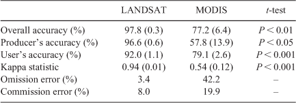
Fire classification accuracy metrics at the landscape scale for Landsat and MODIS fire scars, using Sentinel-2 fire scars as a reference dataset, are reported in Table 1. Producer’s, user’s and overall accuracies were averaged between the four 90 000 ha areas and across the three fire seasons studied.
|
Habitat scale fire mapping
Performance of Landsat and MODIS fire scars at the habitat scale are reported in Table 2. This part of the study was done at two different resolutions: 120 m by 120 m plots and 500 m by 500 m plots. MBE, which gives an indication of over- or under-estimation, and RMSE, which gives an indication of the mean relative error of the estimates, were calculated by grouping plots according to area burnt based on Sentinel-2 fire scars. At a resolution of 120 m by 120 m, Landsat is able to provide accurate estimates in plots that are completely unburnt or completely burnt (MBE 1.2% and 1.9%, respectively). At this scale, however, Landsat provides overestimated and highly variable burn percentage estimates for areas that have been partially burnt (RMSE 23.9% and 14.1%). In 500 m × 500 m plots, Landsat provides accurate estimates for all burn percentages studied (MBE 0%, 3.5%, 3.7% and 0.2%). MODIS accuracy at the habitat scale is high when predicting fully unburnt plots at 500 m resolution (MBE 1.0% and RMSE 8.8%), whereas for all other estimates, variability is higher (RMSE from 38.8% to 49.9%).

|
Sub-regional and landscape scale fire mapping: years since last burn comparison
Years since last burn raster layers produced with Landsat and MODIS fire scar maps were overlayed and the level of agreement, at the sub-regional and landscape scales, is reported in Fig. 3. At the sub-regional scale, coincident years since last burn pixels (which includes pixels where years since last burn is the same or +/1) account for 64% and 68% of the sub-regions’ area, respectively. At the landscape scale, these values are more variable between the two studied areas (54% and 75%, respectively). At both scales MODIS tends to overestimate years since last burn, which is coherent with the large omission errors observed at the landscape scale during the comparison process.

|
Fig. 4 shows years since last burn maps generated with Landsat and MODIS fire scar maps at the landscape scale. In the exact same extents, areas that appear white (not burnt), cover a larger proportion of the landscape in the MODIS years since last burn maps, and are caused by MODIS omission errors observed at this scale.

|
Sub-regional and landscape scale fire mapping: annual burnt area comparison
Annual burnt area from Landsat and MODIS fire scar maps, at the sub-regional and landscape scales, are reported in Figs 5 and 6. At the sub-regional scale, Landsat and MODIS burnt area estimates follow similar trends, although differences can be observed, particularly in years 2000 to 2003, 2008, 2013, 2015, 2017 and 2018 (Fig. 5). For most years, Landsat burn area estimates are larger than MODIS’s. Magnitude of difference is variable and may be related to either MODIS omission errors or to the 1-year lag explained earlier.

|

|
At the landscape scale (Fig. 6), annual differences between both datasets are larger.
Fire scar comparison
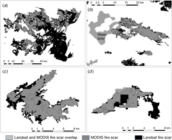
A visual analysis of all Landsat and MODIS mapping that compares fire scars across all sub-regions was not performed. However, Landsat fire scar boundaries have been compared with those from MODIS in the same area on the same year to exemplify some fundamental differences (Fig. 7). These differences include omission errors that are likely due to small burnt areas (Fig. 7c, d) and recently burnt vegetation, which is sparse, re-burning (Fig. 7a). A commission error, with an ephemeral waterbody mapped as a fire, is also shown (Fig. 7b).
|
Management outcomes: years since last burn comparisons
We further investigated management implications of the different levels of accuracy at the sub-regional and landscape scales. Fig. 8 shows the percentage of each studied sub-region and landscape in which MODIS provided a 10 year or more over- and under-estimation of time since last burn. These results indicate that, for example, if a practitioner using MODIS fire scar maps were to select a random area within Landscape 1 to estimate its years since last burn, the practitioner should be aware that 13% of the landscape (equivalent to 11 700 ha in a landscape of 90 000 ha) has had its last burn age overestimated by more than 10 years.

|
Discussion
The results of this study suggest the choice of satellite imagery that land managers use to assess the fire history of a large (desert) area should depend upon the spatial scale targeted for management. For the Great Victoria Desert, we used an independently generated Sentinel-2 10 m resolution fire scar dataset to validate Landsat and MODIS fire scar maps at two spatial scales (landscape and habitat). Although all data that are based on the interpretation of imagery will be subject to some degree of error, we found that mapping from Landsat imagery provided relatively lower errors at both the smaller habitat and wider landscape scales to detect and profile fire scars when compared with MODIS.
Comparison of Landsat and MODIS fire scar mapping: landscape and habitat scales
Our study highlights that MODIS fire scar maps used in this study frequently miss burnt areas. The spectral characteristics of burnt areas in the desert, together with the limited spectral information in MODIS used to generate the fire scars, may provide an insight to explain this discrepancy. NAFI identifies areas in which MODIS near infrared (NIR) band reflectance has decreased (Jacklyn 2017). This change in reflectance is related to a darkening of vegetation caused by carbonisation and occurs in the tropical savannas of northern Australia, where MODIS is primarily applied (Jacklyn 2017). In desert environments, however, vegetation composition is structurally and spatially sparser: a burnt open area may initially signal a strong negative reflectance response shortly after a fire, but wind and similar factors may reduce ash cover to produce a positive reflectance due to an increased exposure of the sand. It might be reasonable to think that given the high frequency of MODIS capture (four times per day), there should be little issue detecting ash reflectance. However, NAFI fires are produced by comparing two satellite images that are generally 1 or 2 weeks apart (Jacklyn 2017). If within that time period, the presence of ash and carbonised vegetation is reduced, and/or if a particular fire burnt through very sparse vegetation, exposed sand will dominate the spectral signature of burnt areas, causing an increase of NIR reflectance, which is not detected by the NAFI method. We hypothesise that this effect could be the cause behind the high level of omission errors by MODIS in desert environments with large patches of exposed sand. However, a comprehensive assessment of omissions should be performed to identify the main cause of these errors with more certainty.
MODIS fire scar maps generated by NAFI displayed relatively lower and more stable commission error compared with its omission error, which is consistent with other assessments of MODIS fire scar accuracy found elsewhere (Roy and Boschetti 2009; Liu et al. 2018). However, a commission error of 19.9% indicates that a significant proportion of unburnt areas are still being mapped as burnt. This could be caused by two factors. First, a ground spatial resolution of 250 m suggests that fire edges are likely to be rectangular and potentially include adjacent unburnt areas (see Fig. 7c, d). It also means that internal unburnt patches under a certain size are likely to be missed and classified as fire. Second, the vast extent mapped by NAFI on a monthly basis (almost 75% of the Australian land mass), makes it more likely for human supervision to miss areas that have suffered a reduction in NIR reflectance when these are actually unburnt areas (e.g. ephemeral water bodies, Fig. 7b).
Landsat fire scar maps had high producer’s accuracies, suggesting our method is unlikely to miss a historical fire (omission error of 3.4%). This result outperforms similar studies assessing the producer accuracy of Landsat (Hudak and Brockett 2004; Bastarrika et al. 2011; Goodwin and Collett 2014; Vanderhoof et al. 2017) but is comparable to results provided by Stroppiana et al. (2012) who also use a combined spectral index approach. In our study, improved performance in Landsat compared with MODIS can be explained by the broader range of spectral information used to generate the fire scars. By identifying changes in two different spectral indices (dNBR and dB4), we were able to detect burnt areas with different spectral characteristics. Recently burnt areas show low reflectance in the NIR and high reflectance in the short wave infrared (SWIR). Consequently, we were able to map recent fires by identifying a decrease in NBR. Older burnt areas in which burnt vegetation has disappeared and soil is exposed will see a sharp increase in NIR reflectance. Contrary to the NAFI process, our method identified areas with an increase in NIR reflectance, allowing us to map this type of fire scars.
Our results also show that the main component of Landsat error is commission error (8.0%), which is consistent with previous studies (Goodwin and Collett 2014; Vanderhoof et al. 2017; Liu et al. 2018). This is likely caused by inaccuracies in fire edge delineation as well as internal unburnt patches being mapped as burnt.
At the habitat scale, we show that Landsat can be confidently used to estimate burn area in plots as small as 500 m × 500 m (with small overestimation errors probably related to rectangular edges and missed internal unburnt patches), whereas at lower resolutions (120 m) we only get accurate estimates if plots are fully burnt or fully unburnt. This is consistent with Landsat resolution (30 m) and with low omission and commission errors reported at the landscape scale. MODIS errors at the habitat scale are larger, reflecting a coarser spatial resolution. Although large omission and commission errors were observed at the landscape scale, MODIS can quite accurately identify fully unburnt 500 m × 500 m plots.
Mapping effort
An important factor to consider when comparing different satellite products in the context of their application to land management projects is the effort (time, and implicitly costs) involved in obtaining the final product. Time to process raw satellite data into fire scar datasets depends, among other factors, on the skill of the operator. In our case, processing of all Landsat and Sentinel-2 satellite datasets has been performed by the same operator, software and hardware, standardising the comparison of processing time between products. It took several weeks to map 25 years of fire history over an area of 21.8 million ha (8.5% of the area of Western Australia) using Landsat imagery. In relative terms (averaged as time required to map a unit area), Sentinel-2 mapping required ~5 times more effort (4.3 h per 10 000 km2) than the Landsat mapping (51 min per 10 000 km2). In our study, MODIS fire scars were downloaded from the NAFI website, so the operator time to use NAFI-generated MODIS fire scars was virtually negligible. However, as we illustrate, these results come with some – and at times high – detection errors depending on the spatial scale of interest by land managers. Although Sentinel-2-based datasets offer a higher resolution option (and implicitly higher accuracy) for smaller areas, managers need to factor in the higher time and therefore cost associated with processing the data. Therefore, we suggest that for the purpose of mapping fire history in the Great Victoria Desert, Landsat imagery analysed through the method we have described provides the right balance between required accuracy levels and time/cost considerations.
In this regard, many studies that have used Landsat to map fire scars have focussed on developing algorithms that can be efficiently automated to work over large areas and involve low levels of supervision (Hudak and Brockett 2004; Stroppiana et al. 2012; Goodwin and Collett 2014), and less effort compared with the method presented here. Results seem appropriate for monitoring burnt area trends over scales such as landscapes (30 km by 30 km area) and over larger areas covered by several Landsat scenes (180 km by 180 km each). However, these methods show levels of commission and omission errors (mostly above 10% for both error types) that could translate into detection inaccuracies with implications for burn planning on the ground (e.g. planning resource time for ground burns in unsuitable habitats).
Years since last burn comparisons: management applications
Large proportions of a landscape (from 8 to 15% in our two Landscape examples in Fig. 8) where vegetation age has been over- or under-estimated by more than 10 years could have significant negative implications in terms of survey planning and field operations and, ultimately, conservation outcomes. Our results at the plot scale indicate that fire history can be predicted more confidently within a 500 m × 500 m plot using Landsat, but less so in a smaller plot of 120 m by 120 m. This might be useful for ecological studies where sampling needs to focus on particular fire ages. For example, a fauna study plot planned to be within a certain vegetation age using Landsat fire history would have to be established within a patch of that fire age that is at least 500 m × 500 m. Therefore, improving the accuracy of satellite-derived fire maps for these desert biomes has practical – and cost – implications to fire management planning.
Although all three fire scar products presented in this study (MODIS, Landsat and Sentinel-2) provide valuable fire history information at various scales, each have their use and their limitations when applied to management practices on the ground. In this context, we have identified the advantages and disadvantages associated with each mapping approach to support fire managers and scientists working with remote sensing maps in desert environments (Table 3). We demonstrate that Landsat data provides an accurate and verifiable approach across a broad range of spatial scales for mapping the fire history of desert regions such as the Great Victoria Desert. Consequently, it can support reliable fire planning and prescribed fire management, and it may be a useful tool for future opportunities such as carbon farming surveillance under the Australian Emissions Reduction Fund (South Pole 2019) to manage landscapes and habitats for fire. The application of Landsat is designed to be as reliable as possible while balancing user-time and costs associated with image interpretation. Our work serves as primary data for a broader assessment of the recent fire history and associated vegetation fire parameters of the wider landscape across the Great Victoria Desert, and for delivering ecologically sustainable fire management in this bioregion.

|
Authors’ contributions
D.M. and R.V.D. conceived the initial idea of comparing Landsat and MODIS fire scars in the Great Victoria Desert. R.V.D. and J.R.A. further developed this idea to incorporate Sentinel-2 as a reference dataset. D.M. conceptualised the paper’s scope, structure and the fire management applications. J.R.A. generated and analysed all the Landsat and Sentinel-2 data, as well as all comparisons between Landsat, Sentinel-2 and MODIS, with collaboration and supervision from R.V.D. J.R.A. led the writing of the manuscript, with substantial contributions from D.M. in the Introduction and Discussion, and from R.V.D. in the Methods and Results. All authors contributed critically to the drafts and gave final approval for publication.
Conflicts of interest
The authors declare no conflicts of interest.
Declaration of funding
We thank the Great Victoria Desert Biodiversity Trust (GVDBT) for financial support to develop fire history mapping for this investigation.
Acknowledgements
We thank Gareth Catt and Hannah Cliff (Desert Support Services), Katherine Zdunic (Department of Biodiversity, Conservation and Attractions) and Katherine Sinclair (GVDBT) who provided valuable comments on an earlier version of this manuscript, as well as Peter Jacklyn and Rohan Fisher (NAFI) for their insights into NAFI fire scar mapping processes. We also thank the three anonymous reviewers and the Associate Editor who helped improve the final version of this paper.
References
Allan GE, Southgate RI (2002) Fire regimes in spinifex landscapes. In ‘Flammable Australia: The Fire Regimes and Biodiversity of a Continent’. (Eds RA Bradstock, JE Williams, MA Gill) pp. 145–176. (CSIRO Publishing: Melbourne)Bastarrika A, Chuvieco E, Martin MP (2011) Mapping burned areas from Landsat TM/ETM+ data with a two-phase algorithm: Balancing omission and commission errors. Remote Sensing of Environment 115, 1003–1012.
| Mapping burned areas from Landsat TM/ETM+ data with a two-phase algorithm: Balancing omission and commission errors.Crossref | GoogleScholarGoogle Scholar |
Beard J, Beeston G, Harvey J, Hopkins A, Shepherd D (2014) The vegetation of Western Australia at the 1: 3,000,000 scale. Explanatory memoir. Conservation Science Western Australia 9, 1–152.
Benshemesh J, Bode M (2011) Adaptive management of Malleefowl. In ‘Proceedings of the 4th National Malleefowl Forum 2011’ (Ed. S Gillian), pp. 126–135.
Bird RB, Bird DW, Codding BF, Parker CH, Jones JH (2008) The “fire stick farming” hypothesis: Australian Aboriginal foraging strategies, biodiversity, and anthropogenic fire mosaics. Proceedings of the National Academy of Sciences of the United States of America 105, 14796–14801.
| The “fire stick farming” hypothesis: Australian Aboriginal foraging strategies, biodiversity, and anthropogenic fire mosaics.Crossref | GoogleScholarGoogle Scholar |
Bird RB, Codding BF, Kauhanen PG, Bird DW (2012) Aboriginal hunting buffers climate-driven fire-size variability in Australia’s spinifex grasslands. Proceedings of the National Academy of Sciences of the United States of America 109, 10287–10292.
| Aboriginal hunting buffers climate-driven fire-size variability in Australia’s spinifex grasslands.Crossref | GoogleScholarGoogle Scholar |
Boschetti L, Roy DP, Giglio L, Huang H, Zubkova M, Humber ML (2019) Global validation of the collection 6 MODIS burned area product. Remote Sensing of Environment 235, 111490
| Global validation of the collection 6 MODIS burned area product.Crossref | GoogleScholarGoogle Scholar | 32440029PubMed |
Burrows ND, Chapman J (2018) Traditional and contemporary fire patterns in the Great Victoria Desert. Final Report, Great Victoria Desert Biodiversity Trust Project GVD-P-17-002.
Burrows N, Christensen P (1991) A survey of aboriginal fire patterns in the Western Desert of Western Australia. In ‘Proceedings of the International Symposium on Fire and the Environment: Ecological and Cultural Perspectives’, 1991 (Eds SC Nodvin, TA Waldrop), pp. 297–305. (USDA Southeastern Forest Experiment Station)
Burrows N, Ward B, Robinson A (1991) Fire behaviour in spinifex fuels on the Gibson Desert nature reserve, Western Australia. Journal of Arid Environments 20, 189–204.
| Fire behaviour in spinifex fuels on the Gibson Desert nature reserve, Western Australia.Crossref | GoogleScholarGoogle Scholar |
Burrows ND, Burbidge AA, Fuller PJ, Behn G (2006) Evidence of altered fire regimes in the Western Desert region of Australia. Conservation Science Western Australia 5, 272–284.
Congalton RG (1991) A review of assessing the accuracy of classifications of remotely sensed data. Remote Sensing of Environment 37, 35–46.
| A review of assessing the accuracy of classifications of remotely sensed data.Crossref | GoogleScholarGoogle Scholar |
Fernández A, Illera P, Casanova JL (1997) Automatic mapping of surfaces affected by forest fires in Spain using AVHRR NDVI composite image data. Remote Sensing of Environment 60, 153–162.
| Automatic mapping of surfaces affected by forest fires in Spain using AVHRR NDVI composite image data.Crossref | GoogleScholarGoogle Scholar |
Fisher R, Edwards AC (2015) Fire extent and mapping: procedures, validation and website application. In ‘Carbon Accounting and Savanna Fire Management’. (Eds BP Murphy, AC Edwards, CP Meyer, J Russell-Smith) pp. 57–72. (CSIRO Publishing: Melbourne, Australia)
Goodwin NR, Collett LJ (2014) Development of an automated method for mapping fire history captured in Landsat TM and ETM+ time series across Queensland, Australia. Remote Sensing of Environment 148, 206–221.
| Development of an automated method for mapping fire history captured in Landsat TM and ETM+ time series across Queensland, Australia.Crossref | GoogleScholarGoogle Scholar |
Griffin G, Price N, Portlock H (1983) Wildfires in the central Australian rangelands, 1970–1980. Journal of Environmental Management 17, 311–323.
Haydon DT, Friar JK, Pianka ER (2000) Fire-driven dynamic mosaics in the Great Victoria Desert, Australia–II. A spatial and temporal landscape model. Landscape Ecology 15, 407–423.
| Fire-driven dynamic mosaics in the Great Victoria Desert, Australia–II. A spatial and temporal landscape model.Crossref | GoogleScholarGoogle Scholar |
Hudak A, Brockett B (2004) Mapping fire scars in a southern African savannah using Landsat imagery. International Journal of Remote Sensing 25, 3231–3243.
| Mapping fire scars in a southern African savannah using Landsat imagery.Crossref | GoogleScholarGoogle Scholar |
Jacklyn P (2017) Extending NAFI Fire History Mapping. Report number GVD-P-17-001, Great Victoria Desert Biodiversity Trust.
Kettig RL, Landgrebe D (1976) Classification of multispectral image data by extraction and classification of homogeneous objects. IEEE Transactions on Geoscience Electronics 14, 19–26.
| Classification of multispectral image data by extraction and classification of homogeneous objects.Crossref | GoogleScholarGoogle Scholar |
Key CH, Benson NC (1999) Measuring and remote sensing of burn severity. In ‘Proceedings of the joint fire science conference and workshop, 1999’, 15–17 June 1999, Boise, ID. (Eds LF Neuenschwander, KC Ryan) p. 284. (University of Idaho and International Association of Wildland Fire)
Letnic M, Dickman CR (2006) Boom means bust: interactions between the El Niño/Southern Oscillation (ENSO), rainfall and the processes threatening mammal species in arid Australia. Biodiversity and Conservation 15, 3847–3880.
| Boom means bust: interactions between the El Niño/Southern Oscillation (ENSO), rainfall and the processes threatening mammal species in arid Australia.Crossref | GoogleScholarGoogle Scholar |
Liu J, Heiskanen J, Maeda EE, Pellikka PK (2018) Burned area detection based on Landsat time series in savannas of southern Burkina Faso. International Journal of Applied Earth Observation and Geoinformation 64, 210–220.
| Burned area detection based on Landsat time series in savannas of southern Burkina Faso.Crossref | GoogleScholarGoogle Scholar |
Moseby K, Read J, Mclean A, Ward M, Rogers DJ (2016) How high is your hummock? The importance of Triodia height as a habitat predictor for an endangered marsupial in a fire‐prone environment. Austral Ecology 41, 376–389.
| How high is your hummock? The importance of Triodia height as a habitat predictor for an endangered marsupial in a fire‐prone environment.Crossref | GoogleScholarGoogle Scholar |
Pianka ER (1996) Long-term changes in lizard assemblages in the Great Victoria Desert. In ‘Longterm studies of vertebrate communities’. (Eds ML Cody, JA Smallwood) pp. 191–216. (Academic Press: San Diego, CA)
Roy DP, Boschetti L (2009) Southern Africa validation of the MODIS, L3JRC, and GlobCarbon burned-area products. IEEE Transactions on Geoscience and Remote Sensing 47, 1032–1044.
| Southern Africa validation of the MODIS, L3JRC, and GlobCarbon burned-area products.Crossref | GoogleScholarGoogle Scholar |
Russell-Smith J, Ryan PG, Durieu R (1997) A LANDSAT MSS-Derived Fire History of Kakadu National Park, Monsoonal Northern Australial, 1980–94: Seasonal Extent, Frequency and Patchiness. Journal of Applied Ecology 34, 748–766.
| A LANDSAT MSS-Derived Fire History of Kakadu National Park, Monsoonal Northern Australial, 1980–94: Seasonal Extent, Frequency and Patchiness.Crossref | GoogleScholarGoogle Scholar |
South Pole (2019) Feasibility of an ERF method for the 10 Deserts Project. Desert Support Services, Perth.
Southgate R, Paltridge R, Masters P, Carthew S (2007) Bilby distribution and fire: a test of alternative models of habitat suitability in the Tanami Desert, Australia. Ecography 30, 759–776.
| Bilby distribution and fire: a test of alternative models of habitat suitability in the Tanami Desert, Australia.Crossref | GoogleScholarGoogle Scholar |
Srivastava SK, King L, Mitchell C, Wiegand A, Carter R, Shapcott A, Russell-Smith J (2013) Ecological implications of standard fire-mapping approaches for fire management of the World Heritage Area, Fraser Island, Australia. International Journal of Wildland Fire 22, 381–393.
| Ecological implications of standard fire-mapping approaches for fire management of the World Heritage Area, Fraser Island, Australia.Crossref | GoogleScholarGoogle Scholar |
Stroppiana D, Bordogna G, Carrara P, Boschetti M, Boschetti L, Brivio P (2012) A method for extracting burned areas from Landsat TM/ETM+ images by soft aggregation of multiple Spectral Indices and a region growing algorithm. ISPRS Journal of Photogrammetry and Remote Sensing 69, 88–102.
| A method for extracting burned areas from Landsat TM/ETM+ images by soft aggregation of multiple Spectral Indices and a region growing algorithm.Crossref | GoogleScholarGoogle Scholar |
Thackway R, Cresswell ID (1997) A bioregional framework for planning the national system of protected areas in Australia. Natural Areas Journal 17, 241–247.
Tran T, Andriolo A (2015) Native title rights and interests in indigenous protected area management: The Martu and Nyangumarta experience. Native Title Newsletter 8, 8–11.
Vanderhoof MK, Fairaux N, Beal Y-JG, Hawbaker TJ (2017) Validation of the USGS Landsat burned area essential climate variable (BAECV) across the conterminous United States. Remote Sensing of Environment 198, 393–406.
| Validation of the USGS Landsat burned area essential climate variable (BAECV) across the conterminous United States.Crossref | GoogleScholarGoogle Scholar |
Yates CP, Edwards AC, Russell-Smith J (2008) Big fires and their ecological impacts in Australian savannas: size and frequency matters. International Journal of Wildland Fire 17, 768–781.
| Big fires and their ecological impacts in Australian savannas: size and frequency matters.Crossref | GoogleScholarGoogle Scholar |