

Smoke emissions from the extreme wildfire events in central Portugal in October 2017
A. P. Fernandes A , D. Lopes A * , S. Sorte A , A. Monteiro A , C. Gama A , J. Reis A , I. Menezes A , T. Osswald A , C. Borrego A , M. Almeida B , L. M. Ribeiro B , D. X. Viegas B and A. I. Miranda A
A Department of Environment and Planning and Centre for Environmental and Marine Studies (CESAM), University of Aveiro, Campus Universitário de Santiago, 3810-193 Aveiro, Portugal.
B Forest Fire Research Centre (CEIF), Association for the Development of Industrial Aerodynamics (ADAI), University of Coimbra, Rua Pedro Hispano 12, 3030-289 Coimbra, Portugal.
International Journal of Wildland Fire 31(11) 989-1001 https://doi.org/10.1071/WF21097
Submitted: 7 July 2021 Accepted: 15 September 2022 Published: 4 October 2022
© 2022 The Author(s) (or their employer(s)). Published by CSIRO Publishing on behalf of IAWF.This is an open access article distributed under the Creative Commons Attribution-NonCommercial-NoDerivatives 4.0 International License (CC BY-NC-ND)
Abstract
In the last decades, numerous large forest fires have been recorded in Portugal. On 15 and 16 October 2017, seven extreme wildfires events (EWEs) took place in the central region of Portugal. Aiming to contribute to the assessment of the smoke impact of these EWEs, this study estimates their atmospheric emissions using a bottom-up approach with high spatial and temporal resolution. To this end, fire data were used, such as ignition location and time, propagation, burned area, and fuel load and emission factors according to forest species. A particular fire – EWE in Lousã with a high fuel load – emitted ~50% of the sum of the emissions of the six other case studies. The spatial distribution of the EWE emissions indicates that fuel load is an important component of emissions estimation. The obtained results were compared with remote sensing data, showing good agreement in terms of total values. During these EWEs, particulate matter and carbon monoxide emissions were higher than Portuguese anthropogenic emissions in 2017. This approach contributes to the state of the art on forest fire emissions, reducing uncertainty and obtaining the best possible and detailed quantification of the temporal and spatial variability of EWE emissions.
Keywords: bottom-up approach, emissions, extreme events, high resolution, Mediterranean conditions, satellite data, smoke, wildland fire.
Introduction
Wildfires can produce substantial emissions of carbon dioxide (CO2), carbon monoxide (CO), nitrogen oxides (NOx), volatile organic compounds (VOCs) and particulate matter (PM) (Crutzen et al. 1979; Miranda et al. 1994, 2005; Andreae and Merlet 2001; Reddington et al. 2016). These emissions affect global atmospheric chemistry (Spracklen et al. 2007; Jaffe et al. 2008; Monks et al. 2012), impact radiative transfer in the atmosphere (Clinton et al. 2006) and reduce visibility (Wade and Ward 1973; Valente et al. 2007). Moreover, they strongly degrade air quality (Valente et al. 2007; Miranda et al. 2009; Bytnerowicz et al. 2010; Carvalho et al. 2011; Martins et al. 2012; Turquety et al. 2014; Keywood et al. 2015), with significant effects on human health (Miranda et al. 2010, 2012; Johnston et al. 2012; Knorr et al. 2012; Martins et al. 2012; Akagi et al. 2014; Dennekamp et al. 2015; Reid et al. 2016; Apte et al. 2018).
San-Miguel-Ayanz et al. (2013) estimated that 2% of ‘mega-fires’ contribute to 80% of the total area burned in Europe. These extreme wildfire events (EWEs) are usually clusters of fires that burn simultaneously and propagate rapidly owing to critical meteorological conditions, such as hot and dry conditions with strong winds (Pereira et al. 2005), and are particularly difficult to control. There are several examples in which the yearly national emissions of EWE exceed those of anthropogenic activities, despite the former being concentrated in both time and space. Such are the cases of the Portuguese fires in 2003, 2015 and 2017 or the Greek fires in 2007 or the Russian fires in 2010 (Hodzic et al. 2007; Turquety et al. 2009; Konovalov et al. 2011; Hodnebrog et al. 2012; Martins et al. 2012). The fires that occurred in 2017 in central Portugal are the most recent example of large (and deadly) wildfires in Europe, and have not yet been sufficiently investigated (Solomos et al. 2019).
Most forest fire emission studies rely on the model proposed by Seiler and Crutzen (1980) and Ward and Hardy (1991), which is based on information about burned area extent, the amount and type of vegetation burned (fuel types, fuel loads) and the conditions under which fires take place (combustion efficiencies). Emission factors are also used to estimate the amount of emissions of each species (gases and particles). More recently, global satellite-derived burned area information has become available. Thus, the scientific community has put considerable effort into quantifying the impact of wildland fires by remote-sensing approaches to improve these estimates (Giglio et al. 2006; Mouillot et al. 2006; Reid et al. 2009; Mieville et al. 2010; Wiedinmyer et al. 2011; Kaiser et al. 2012; Ichoku and Ellison 2014; Monteiro et al. 2014; Darmenov and da Silva 2015; Chuvieco et al. 2016; van der Werf 2017). Furthermore, instantaneous fire radiative power (FRP) is used nowadays as a measure of the rate of radiant energy emission from the fire to derive the amount of fuel burned directly (Freeborn et al. 2008), in particular, to facilitate real-time applications (Sofiev et al. 2009; Kaiser et al. 2012).
Although much progress has been made over the last couple of decades in improving the quality of vegetation fire emission datasets (e.g. Pereira et al. 2009; van der Werf et al. 2010, 2017; Sofiev et al. 2013; Rémy et al. 2017; Prichard et al. 2020), uncertainties are still an issue but are poorly estimated and considered in modelling, mainly at regional and local levels (e.g. Liousse et al. 2010; Kaiser et al. 2012; Petrenko et al. 2012; Bond et al. 2013; Zhang et al. 2014; Ichoku et al. 2016; Pereira et al. 2016; Reddington et al. 2016; Pan et al. 2020). They are mainly associated with fire characteristics (vegetation burned and fuel load consumed) and emission factors (EFs) (Miranda et al. 2008; Ottmar et al. 2008; Langmann et al. 2009). Regarding EFs, the majority of the available information is for United States of America (USA) forest (Urbanski 2013), and it is not a suitable proxy for wildfires in Europe, owing to vegetation cover and the differences in combustion characteristics (e.g. flaming and smouldering phases). Efforts to narrow the uncertainties in the EFs are ongoing in the form of numerous field campaigns and laboratory studies (e.g. Alves et al. 2011; Vicente et al. 2012, 2017; van der Werf et al. 2017).
Thus far, no forest fire emission inventory delivers data with high enough spatial (e.g. ~5 km or better) and temporal (e.g. approximately hourly or better) resolution (e.g. Reid et al. 2009; Shi et al. 2015; Pereira et al. 2016; Reddington et al. 2016). The accuracy and high resolution of fire emissions inventories are particularly important for air quality modelling studies at regional- and local-scale (Miranda et al. 2005; Valente et al. 2007; Akagi et al. 2011; Martins et al. 2012; van Marle et al. 2017; Mota and Wooster 2018).
The main objective of the present study is to estimate the atmospheric emissions from the October 2017 Portuguese EWEs with a high-resolution methodology. We rely on a combination of burned area maps and land cover maps, forest inventory data, statistical growth models for forests and shrublands, and EFs updated according to recently published data. We also compare these emissions with satellite data and with Portuguese anthropogenic emissions.
Emissions estimation methodology
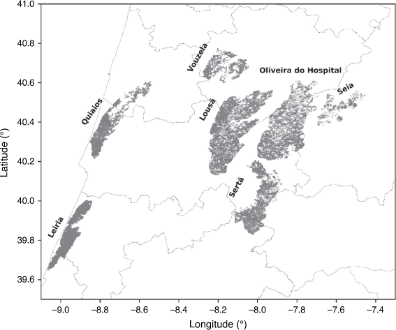
On the morning of 15 October, at 6:00 hours in the central region of Portugal, a serious wildfire situation started and developed into seven EWEs that lasted until 8:00 hours on 16 October. The dry vegetation and soil due to the hot and dry season throughout 2017, combined with the strong and persistent southerly winds caused by the close passage of hurricane Ophelia to the Portuguese mainland, increased the intensity of the EWEs (Turco et al. 2019; Augusto et al. 2020). Fig. 1 shows the location of the seven EWEs.
|
Atmospheric emissions during these EWEs were estimated using a bottom-up methodology based on the following equations that should be well known (e.g. Wiedinmyer et al. 2006; Carvalho et al. 2011):


where Ei is the emission of compound i (g), EFi the EF for compound i (g kg−1), FC is fuel consumption (kg m−2), β the burning efficiency, B the fuel load (kg m−2), and A the burned area (m2) (Wiedinmyer et al. 2006; Carvalho et al. 2011).
The hourly fire progression (burned area) was estimated based on detailed data collected by the Associação para o Desenvolvimento da Aerodinâmica Industrial (Viegas et al. 2019) (see Burned area below), while fuel load data over the study areas were obtained using the National Forest Inventory (ICNF 2019) and Portuguese land use data (DGT 2018) with a high horizontal spatial resolution (see Fuel load). A literature review was performed to obtain the burning efficiency values (Burning efficiency) and the most suitable EFs (Emission factors) to be considered for the 2017 EWEs.
The uncertainty for the estimated emissions was quantified applying the Monte Carlo approach. Random values were generated for each input parameter (i.e. EF, burning efficiency and fuel load) assuming a normal distribution and taking their coefficient of variation into account.
According to Ottmar et al. (2008), the coefficient of variation for the EFs is 16%, for the burning efficiency, 30% and for the fuel load, 83%. Notwithstanding the focus of the analysis of Ottmar et al. (2008) on a region in the USA, these coefficients of variation were considered in the present study assuming that methods for the quantification of EFs, burning efficiency and fuel load parameters were similar to those used in Portugal. Multiple runs (maximum of 500 iterations) were performed until results converged (i.e. an average difference less than 0.3% between multiple runs).
Burned area
Fire data, such as ignition location and time and burned area, for each EWE were acquired from the report delivered by the Associação para o Desenvolvimento da Aerodinâmica Industrial (Viegas et al. 2019). This report resulted from a careful and detailed study based on fire data collected in the field, namely on many interviews with operational and affected people, among others who experienced the fire first-hand. These interviews enabled the identification of a set of thousands of georeferenced points with an associated time. In many cases, the time information was confirmed by registration on mobile phones, as people tried to call when the fire reached the surroundings of their homes. Further, several photographs and videos of fire progression were considered. Notwithstanding the great effort to obtain a rigorous determination of fire spread, owing to the extent of the burned area and the complexity of the EWEs, slight deviations are still expected. This detailed information allowed the different ignition points and how the fires spread and affected the territories to be inventoried and therefore estimation of the burned area with a high spatial and temporal resolution. Table 1 shows a summary of the information on burned area, ignition time and wildfire duration considered in this work to estimate the emissions for each EWE (Viegas et al. 2019).

|
According to the information provided by the report of ADAI on these EWEs (Viegas et al. 2019), the first forest fire warning was issued in Seia, where 17 003 ha of forest and shrubland were burned. Four hours later, a second occurrence was registered in Lousã, where 54 407 ha were burned. The fire in Oliveira do Hospital started at 10:26 hours and resulted in the destruction of several houses and industrial facilities as well as burning a vast area (51 429 ha). In Sertã, the fire started at ~12:00 hours on 15 October (30 977 ha burned). In the coastal zone of Portugal, the first forest fire ignition occurred at ~14:00 hours in Leiria and Quiaios with burned areas of 20 014 and 23 844 ha, respectively. The last forest fire alert was registered at 17:21 hours in Vouzela, with the smallest burned area (15 959 ha).
Fuel load
Fuel load was obtained from the sixth Portuguese Forest Inventory (ICNF 2019), which is based on data collection from aerial images and vegetation measurements on the ground (~12 000 measurement sites) across the Portuguese mainland in 2015. This inventory provides surface fuel load by land-use type (trees, under vegetation cover, standing trees, fallen trees, stump and foliage) and forest species (acacia, carob, chestnut, cork oak, eucalyptus, holm oak, oaks, other hardwoods, other resinous, Pinus pinaster and stone pine) for the Portuguese Nomenclature of Territorial Units for Statistical Purposes (NUTS) III.
To improve the spatial distribution of the fuel load data over the study areas, values were spatially disaggregated using the Portuguese land use data (Carta de Uso e Ocupação do Solo – COS) (DGT 2018) and applying an area-weighting technique. The COS dataset was produced based on visual interpretation of orthorectified aerial images with a spatial resolution of 0.5 m. Other sources of information, including satellite images, were also used during the production process as well as in quality control. This database provides information on the areas covered by different forest species (acacia, chestnut, eucalyptus, holm oak, oaks, other hardwoods, other resinous, Pinus pinaster and stone pine) with a minimum cartographic unit, minimum distance between lines and minimum polygon width of 1 ha, 20 and 20 m, respectively.
In addition, measurement datasets (7964 sites across the Portuguese mainland) provided by the Portuguese Institute for Nature Conservation and Forests were also used to improve the accuracy of the estimated fuel load as well as the identification of the forest species in the study area. This joint compilation of data allowed reduction in the uncertainty of the fuel load considered, as well as producing fuel load maps per forest species with a high spatial horizontal resolution.
Burning efficiency
Burning efficiency was introduced to the emissions study community at least as early as 1991 by Ward and Hao (1991). Usually, burning efficiency is defined as the ratio of carbon released as carbon dioxide (CO2) to the total carbon present in the fuel (Miller 2011). In field and laboratory experiments, burning efficiency can be expressed as the fraction burned relative to the total available biomass. Many researchers relate burning efficiency with fire type (surface fire, crown fire or ground fire), fire phase (smouldering or flaming), and other factors such as wind speed, month of occurrence (vegetation has different water contents in spring and summer), soil moisture and even different slope aspect (Kauffman et al. 2003; Miranda et al. 2005; Chang and Song 2010; van der Werf et al. 2010; Akagi et al. 2011; Guo et al. 2017). Despite the difficulty in accurately estimating it, there is a wide range of burning efficiency data (e.g. PNAC 2002; Miranda et al. 2005; Wiedinmyer et al. 2006; Martins et al. 2012; Urbanski 2013) for shrubs and forest species. In the present study, for shrubs, a burning efficiency value of 0.8, suggested by the National Program for Climate Changes (PNAC 2002), was selected because it represents Portuguese conditions for understorey vegetation as well as fine fuel from other vegetation species. Regarding forest, a burning efficiency value of 0.25 was taken from the EEA (2019) guidance document as representing southern European forest species, namely communities of eucalyptus, and resinous and deciduous trees.
Emission factors
Emission factors for southern European conditions were chosen based on a bibliographic review taking into consideration Portuguese land-use types, as well as considering values selected by previous studies (Miranda 2004; Alves et al. 2011; Martins et al. 2012; Vicente et al. 2012, 2017; van der werf et al. 2017). Most of the studies reported in the literature provide EFs for American fuels (e.g. McMeeking et al. 2009; Akagi et al. 2011) and savannas or pastures, tropical and extratropical forests (van der Werf et al. 2017), with few studies for Mediterranean species. Table 2 lists the average EFs (in g kg−1 fuel burned, dry basis) for the relevant air pollutants. All reported values were obtained from experimental forest fires.

|
The EFs listed for eucalyptus, acacia and Pinus pinaster species express the average of the EFs obtained experimentally in Portugal by Alves et al. (2011) and Vicente et al. (2012, 2017). These averages were calculated using the harmonic mean (Fujioka 1985). The EFs reported by van der Werf et al. (2017) were used for the other hardwoods species. The EFs for other resinous, oak, chestnut, cork oak and stone pine species were obtained from Miranda (2004). Emission factors still are one of the main uncertainty sources in emissions estimations, and it is important to work on this topic with more field measurements, in particular for southern European conditions.
Results
The methodology considered for analysing the obtained atmospheric emissions was based on approaches used in similar previous studies (e.g. Giglio et al. 2006; Mouillot et al. 2006; Reid et al. 2009; Mieville et al. 2010; Wiedinmyer et al. 2011; Kaiser et al. 2012; Ichoku and Ellison 2014; Monteiro et al. 2014; Darmenov and da Silva 2015; Chuvieco et al. 2016; van der Werf et al. 2017). In Emission data and maps, the spatial distribution and hourly total atmospheric emissions of the main smoke pollutants are shown and discussed. The impact of each EWE (e.g. Leiria and Lousã) and forest species (e.g. eucalyptus and other resinous) on total emissions was analysed. The results were also compared with data from other approaches (Comparison with satellite data), and with emissions from anthropogenic sectors in mainland Portugal (Smoke vs anthropogenic emissions). The main purpose of these comparisons was to understand the accuracy and magnitude of the atmospheric emissions during the study period.
Emission data and maps
The analysis of the atmospheric emissions (particles with an aerodynamic diameter smaller than 10 µm – PM10 – and 2.5 µm – PM2.5, NOx, CO, SO2, NH3, CO2 and CH4) from the seven EWEs between 15 and 16 October 2017 was based on their spatial and hourly distributions, as well as on the total emissions by case (Quiaios, Vouzela, Lousã, Oliveira do Hospital, Seia, Sertã and Leiria) and by burned species (acacia, chestnut, cork oak, eucalyptus, oak, other hardwoods, other resinous, Pinus pinaster and stone pine).
Fig. 2 shows the spatial distribution (500 × 500 m2) of the atmospheric pollutant emissions (in kt) during the EWEs.

|
The spatial correlation coefficient between the different atmospheric pollutants (e.g. PM10 vs PM2.5) ranged from 0.81 to 0.99, showing that the analysed pollutants have a similar spatial distribution. The lowest correlation values (0.81–0.90) were calculated when comparing the spatial distribution of NH3 with the other atmospheric pollutants. As the SO2 and NH3 EFs are the same for the most representative species (except other hardwoods) in the study areas (Table 1) and their spatial distributions are similar to those from the remaining pollutants (PM10, PM2.5, NOx, CO, CO2 and CH4), fuel load is the main parameter that affects the spatial distribution of the estimated emissions.
The highest emission values were estimated for the Lousã EWE, where the available fuel load was higher mainly owing to the high percentage of acacia covering the area (41.1%), with a fuel load of 6238.5 kt. Based on spatial distribution, it was possible to quantify the maximum emissions (over space) of the different EWEs in relation to the Lousã event: 88.1% (in Quiaios), 95.6% (in Vouzela), 60.0% (in Oliveira do Hospital), 95.8% (in Seia), 58.0% (in Sertã) and 71.1% (in Leiria). The lowest maximum value was obtained in Vouzela, which is an area mainly covered by Pinus pinaster (83.5%), with an average fuel load of 364.7 kt (87.2% less than the average Lousã fuel load).
To understand the temporal distribution of PM10, PM2.5, NOx, CO, SO2, NH3, CO2 and CH4 atmospheric emissions from each EWE, Fig. 3 presents hourly emissions (in kt) during the study period.

|
Fig. 3 shows that the Lousã, Leiria and Sertã EWEs were the largest contributors, with emissions from the Lousã EWE predominating. The period with the highest total emission values lasted for 12 h, between 15:00 hours on 15 October and 02:00 hours on 16 October. The time with highest emission values was 21:00 hours on 15 October, with the biggest contribution from the Lousã EWE (61.38%) and Leiria EWE (21.58%). Furthermore, the temporal distribution profiles of the pollutants were similar, but with different absolute values, because for each pollutant, the burned area, burning efficiency and fuel load values considered varied the same way.
The total emissions (in space and in time) of PM10, PM2.5, NOx, CO, SO2, NH3, CO2 and CH4 were estimated for each case study and are presented in Fig. 4.

|
For NH3, the estimated highest total emissions were in the Lousã EWE (5.22 ± 0.91 kt), followed by Sertã (3.25 ± 0.75 kt), Leiria (2.77 ± 0.51 kt), Oliveira do Hospital (1.15 ± 0.24 kt), Quiaios (0.94 ± 0.15 kt), Vouzela (0.08 ± 0.1 kt) and Seia (0.03 ± 0.01 kt), whereas for the remaining atmospheric pollutants, the largest total emissions were in the Lousã EWE, followed by Leiria, Sertã, Quiaios, Oliveira do Hospital, Vouzela and Seia.
The emissions in Lousã were 43.4–45.8% higher than the sum of emissions from all the other case studies. This EWE was responsible for the largest burned area (54 407 ha – Table 1) and also had the highest available fuel load (15 188.8 kt). The lowest emissions were calculated for the Seia EWE (17 003 ha – Table 1) and Vouzela EWE (15 959 ha – Table 1), which are the regions with the smallest burned area, representing 0.19–0.32% and 0.61–0.63%, respectively, of the total emissions in the study region.
The contribution of each forest species considered in this work for the total emissions of PM10, PM2.5, NOx, CO, SO2, NH3, CO2 and CH4 is also shown in Fig. 5.

|
According to Fig. 5, the forest species that contributed the largest emission values were Pinus pinaster (37.49–42.47%) and eucalyptus (22.65–23.12%), followed by acacia (13.87–19.56%), chestnut (10.76–12.40%) and other hardwoods (4.45–6.77%). That contribution profile was obtained for all pollutants considered (PM10, PM2.5, NOx, CO, SO2, NH3, CO2 and CH4).
Comparison with satellite data
To compare the obtained results with data from other approaches, Fig. 6 shows the PM10 and PM2.5 emissions from the wildfires events between 15 and 16 October 2017 (~24 h) from MODIS (Moderate Resolution Imaging Spectroradiometer) and SEVIRI (Spinning Enhanced Visible and InfraRed Imager) sensors. To facilitate comparison between the results obtained by the different approaches (SEVIRI vs bottom-up vs MODIS), Fig. 6 presents the PM10 and PM2.5 emission values with a horizontal spatial resolution of 10 × 10 km2 for the study period.

|
MODIS is onboard the polar-orbiting satellite platforms Terra and Aqua. It provides data with 1 × 1 km2 horizontal resolution and typically makes two to four overpasses per day over each specific region of the globe (Sofiev et al. 2013). SEVIRI is onboard the Meteosat Second Generation (MSG) geostationary satellite, supplying measurements at 15-min temporal resolution; however, the pixel size of 3 km is coarser than for MODIS (Turquety et al. 2014). The high temporal coverage of the SEVIRI observations increases the probability of detecting a fire, but the coarse spatial horizontal resolution (3 × 3 km2) increases the limit of detection and small fires may be missed (Turquety et al. 2020). Detailed information on the methodology applied to estimate the atmospheric emissions of wildfires using the SEVIRI and MODIS sensors is presented in Sofiev et al. (2013).
The ratios between the PM2.5 and PM10 emissions were on average 0.99 (SEVIRI), 0.94 (bottom-up) and 0.99 (MODIS). Table 1 shows that the PM2.5/PM10 EF ratios for the main vegetation species in the study area ranged from 0.76 to 0.91 (average 0.87). In this bottom-up study, the spatial distribution of PM10 and PM2.5 emissions covered the seven EWEs, whereas with the MODIS and SEVIRI approaches, some burned areas did not show atmospheric emissions. These results are probably due to the coarse spatial (3 × 3 km2) and temporal (two to four overpasses per day) resolutions of the SEVIRI and MODIS sensors, respectively. Table 3 summarises the SEVIRI, bottom-up and MODIS results presented in Fig. 6.

|
With the different approaches, the highest PM10 and PM2.5 emissions were obtained at different EWEs: for SEVIRI in Sertã, PM10, 6.13 kt; PM2.5, 6.08 kt; present study in Lousã: PM10, 50.8 kt, PM2.5, 50.3 kt; MODIS in Lousã, PM10, 109 kt; PM2.5, 108 kt (Table 3). The difference between the maximum values from the current study and the other two approaches ranged between −44.7 kt (SEVIRI) and +58.2 kt (MODIS) for PM10 and from −44.3 kt (SEVIRI) to +57.7 kt (MODIS) for PM2.5. The same type of differences were also estimated for the PM10 and PM2.5 total emissions over the study area. For example, calculated PM10 values with the bottom-up approach were on average 4.5 times higher than SEVIRI values and 1.7 times lower than MODIS values.
Smoke vs anthropogenic emissions
To understand the magnitude of the atmospheric pollutant emissions during the study period, Fig. 7 shows PM10, PM2.5, NOx, CO, SO2 and NH3 emissions (in kt) by anthropogenic sector in mainland Portugal for the year 2017 (European Monitoring and Evaluation Programme (EMEP); http://www.emep.int/). The Portuguese atmospheric emissions include the following Selected Nomenclature for Air Pollution (SNAP) activities: SNAP1 – energy production, SNAP2 – commercial, services and residential combustion, SNAP3&4 – industrial combustion and production processes, SNAP5 – extraction and distribution of fossil fuels, SNAP6 – solvents use, SNAP7 – road transport, SNAP8 – maritime transport, aviation and off-road transport, SNAP9 – waste treatment and disposal, and SNAP10 – agriculture.

|
During the EWEs in October 2017 (~ 26 h), wildland fires emitted 2.7, 3.6 and 4.7 times more PM10, PM2.5 and CO, respectively, than Portuguese anthropogenic sources for the entire 2017 year. For NOx, the EWEs emitted a total of 74.9 kt, which is higher than the annual emission from the Portuguese industrial (SNAP3&4 38.2 kt) and road transport (SNAP7 65.6 kt) sectors. The SO2 (15.2 kt) and NH3 (13.4 kt) emissions were lower (on average 4.8 times) than the total emissions from anthropogenic sectors. Notwithstanding these lower emissions, it is important to mention that EWEs emitted more SO2 (15.2 kt) than the annual emissions from public power activity (SNAP1 14.1 kt) as well as more NH3 (13.5 kt) than the Portuguese industrial sector for 2017 (SNAP3&4 5.6 kt).
Conclusions
The present study focuses on estimating the atmospheric emissions resulting from the Portuguese wildfires of 2017 with a high-resolution methodology. Burned area and land cover maps were used, together with forest inventory data for fuel load data and EFs updated for the Portuguese environment (as well as burning efficiency conditions).
Based on estimated emissions, a high-detail spatial analysis was done and the most affected areas were identified. Fuel load has an important role in the final spatial distribution of emissions. The contribution of each forest species tototal emissions, per pollutant, was also assessed, with Pinus pinaster having the highest impact (37.49–42.47%), followed by eucalyptus (22.65–23.12%).
The estimated emissions were then compared with satellite data (SEVIRI and MODIS), showing good agreement in terms of total values. Satellite-based data, however, did not allow detection of the spatial variability found with the current high-resolution approach. These emissions were also compared with the total national anthropogenic emissions throughout the Portuguese territory for the entire year 2017, confirming the extreme importance of this type of event in relation to air quality levels over the year.
This approach contributes to state-of-the-art knowledge on forest fire emissions, reducing the uncertainty level involved in this type of study and obtaining the best quantification – temporal and spatial – of the EWEs that occurred in Portugal in 2017. Unfortunately, it is impossible to fully validate the results by comparison with measured data, but quantitative values obtained indicate that fuel load has a very important role, and the spatial and temporal distributions provide further insights into smoke emission during EWEs. In the near future, these emissions will be used as input data in a chemical transport model and comparison between its results (atmospheric concentrations) and measured air quality data will contribute to validating the approach. Finally, the sample size is limited and is biased towards EWEs, so future work should use more fires across a broader range of severities.
Data availability
The data that support the findings of this study are available from the corresponding author, D. Lopes, on reasonable request.
Conflicts of interest
The authors declare no conflicts of interest.
Declaration of funding
The authors acknowledge the financial support of FEDER through the COMPETE Programme and the national funds from FCT – Science and Technology Portuguese Foundation within the projects FIRESTORM (PCIF/GFC/0109/2017), SmokeStorm (PCIF/MPG/0147/2019), Firesmoke (PTDC/CTA-MET/3392/2020) and BigAir (PTDC/EAM-AMB/2606/2020). The authors also acknowledge the financial support of the European Union’s Horizon 2020 Research and Innovation Action for the FirEUrisk project under grant agreement ID 101003890. We acknowledge financial support to CESAM by FCT/MCTES (UIDP/50017/2020+UIDB/50017/2020+ LA/P/0094/2020), through national funds.
References
Akagi SK, Yokelson RJ, Wiedinmyer C, Alvarado MJ, Reid JS, Karl T, Crounse JD, Wennberg PO (2011) Emission factors for open and domestic biomass burning for use in atmospheric models. Atmospheric Chemistry and Physics 11, 4039–4072.| Emission factors for open and domestic biomass burning for use in atmospheric models.Crossref | GoogleScholarGoogle Scholar |
Akagi SK, Burling IR, Mendoza A, Johnson TJ, Cameron M, Griffith DWT, Paton-Walsh C, Weise DR, Reardon J, Yokelson RJ (2014) Field measurements of trace gases emitted by prescribed fires in southeastern US pine forests using an open-path FTIR system. Atmospheric Chemistry and Physics 14, 199–215.
| Field measurements of trace gases emitted by prescribed fires in southeastern US pine forests using an open-path FTIR system.Crossref | GoogleScholarGoogle Scholar |
Alves C, Vicente A, Nunes T, Gonçalves C, Fernandes AP, Mirante F, Tarelho L, Sánchez de la Campa AM, Querol X, Caseiro A, Monteiro C, Evtyugina M, Pio C (2011) Summer 2009 wildfires in Portugal: Emission of trace gases and aerosol composition. Atmospheric Environment 45, 641–649.
| Summer 2009 wildfires in Portugal: Emission of trace gases and aerosol composition.Crossref | GoogleScholarGoogle Scholar |
Andreae MO, Merlet P (2001) Emission of trace gases and aerosols from biomass burning. Global Biogeochemical Cycles 15, 955–966.
| Emission of trace gases and aerosols from biomass burning.Crossref | GoogleScholarGoogle Scholar |
Apte JS, Brauer M, Cohen AJ, Ezzati M, Pope CA (2018) Ambient PM2.5 reduces global and regional life expectancy. Environmental Science & Technology Letters 5, 546–551.
| Ambient PM2.5 reduces global and regional life expectancy.Crossref | GoogleScholarGoogle Scholar |
Augusto S, Ratola N, Tarín-Carrasco P, Jiménez-Guerrero P, Turco M, Schuhmacher M, Costa S, Teixeira JP, Costa C (2020) Population exposure to particulate matter and related mortality due to the Portuguese wildfires in October 2017 driven by storm Ophelia. Environment International 144, 106056
| Population exposure to particulate matter and related mortality due to the Portuguese wildfires in October 2017 driven by storm Ophelia.Crossref | GoogleScholarGoogle Scholar |
Bond TC, Doherty SJ, Fahey DW, Forster PM, Berntsen T, Deangelo BJ, Flanner MG, Ghan S, Kärcher B, Koch D, Kinne S, Kondo Y, Quinn PK, Sarofim MC, Schultz MG, Schulz M, Venkataraman C, Zhang H, Zhang S, Bellouin N, Guttikunda SK, Hopke PK, Jacobson MZ, Kaiser JW, Klimont Z, Lohmann U, Schwarz JP, Shindell D, Storelvmo T, Warren SG, Zender CS (2013) Bounding the role of black carbon in the climate system: A scientific assessment. Journal of Geophysical Research: Atmospheres 118, 5380–5552.
| Bounding the role of black carbon in the climate system: A scientific assessment.Crossref | GoogleScholarGoogle Scholar |
Bytnerowicz A, Cayan D, Riggan P, Schilling S, Dawson P, Tyree M, Wolden L, Tissell R, Preisler H (2010) Analysis of the effects of combustion emissions and Santa Ana winds on ambient ozone during the October 2007 southern California wildfires. Atmospheric Environment 44, 678–687.
| Analysis of the effects of combustion emissions and Santa Ana winds on ambient ozone during the October 2007 southern California wildfires.Crossref | GoogleScholarGoogle Scholar |
Carvalho A, Monteiro A, Flannigan M, Solman S, Miranda AI, Borrego C (2011) Forest fires in a changing climate and their impacts on air quality. Atmospheric Environment 45, 5545–5553.
| Forest fires in a changing climate and their impacts on air quality.Crossref | GoogleScholarGoogle Scholar |
Chang D, Song Y (2010) Estimates of biomass burning emissions in tropical Asia based on satellite-derived data. Atmospheric Chemistry and Physics 10, 2335–2351.
| Estimates of biomass burning emissions in tropical Asia based on satellite-derived data.Crossref | GoogleScholarGoogle Scholar |
Chuvieco E, Yue C, Heil A, Mouillot F, Alonso-Canas I, Padilla M, Pereira JM, Oom D, Tansey K (2016) A new global burned area product for climate assessment of fire impacts. Global Ecology and Biogeography 25, 619–629.
| A new global burned area product for climate assessment of fire impacts.Crossref | GoogleScholarGoogle Scholar |
Clinton NE, Gong P, Scott K (2006) Quantification of pollutants emitted from very large wildland fires in southern California, USA. Atmospheric Environment 40, 3686–3695.
| Quantification of pollutants emitted from very large wildland fires in southern California, USA.Crossref | GoogleScholarGoogle Scholar |
Crutzen PJ, Heidt LE, Krasnec JP, Pollock WH, Seiler W (1979) Biomass burning as a source of atmospheric gases CO, H2, N2O, NO, CH3Cl and COS. Nature 282, 253–256.
| Biomass burning as a source of atmospheric gases CO, H2, N2O, NO, CH3Cl and COS.Crossref | GoogleScholarGoogle Scholar |
Darmenov A, da Silva AM (2015) The Quick Fire Emissions Dataset (QFED) - Documentation of versions 2.1,2.2 and 2.4. Available at https://ntrs.nasa.gov/citations/2018000525
Dennekamp M, Straney LD, Erbas B, Abramson MJ, Keywood M, Smith K, Sim MR, Glass DC, Del Monaco A, Haikerwal A, Tonkin AM (2015) Forest fire smoke exposures and out-of-hospital cardiac arrests in Melbourne, Australia: A case-crossover study. Environmental Health Perspectives 123, 959–964.
| Forest fire smoke exposures and out-of-hospital cardiac arrests in Melbourne, Australia: A case-crossover study.Crossref | GoogleScholarGoogle Scholar |
DGT (2018) Cartografia de Uso e Ocupação do Solo (COS, CLC e Copernicus). (Direção Geral do Território) Available at https://snig.dgterritorio.gov.pt/rndg/srv/por/catalog.search#/metadata/b498e89c-1093-4793-ad22-63516062891b [In Portuguese]
EEA (2019) EMEP/EEA air pollutant emission inventory guidebook 2019. 11.B Forest Fires.pdf. EA Report No. 13/2019. (European Environment Agency)
| Crossref |
Freeborn PH, Wooster MJ, Hao WM, Ryan CA, Nordgren BL, Baker SP, Ichoku C (2008) Relationships between energy release, fuel mass loss, and trace gas and aerosol emissions during laboratory biomass fires. Journal of Geophysical Research: Atmospheres 113, D01301
| Relationships between energy release, fuel mass loss, and trace gas and aerosol emissions during laboratory biomass fires.Crossref | GoogleScholarGoogle Scholar |
Fujioka FM (1985) Estimating wildland fire rate of spread in a spatially non-uniform environment. Forest Science 31, 21–29.
| Estimating wildland fire rate of spread in a spatially non-uniform environment.Crossref | GoogleScholarGoogle Scholar |
Giglio L, van der Werf GR, Randerson JT, Collatz GJ, Kasibhatla P (2006) Global estimation of burned area using MODIS active fire observations. Atmospheric Chemistry and Physics 6, 957–974.
| Global estimation of burned area using MODIS active fire observations.Crossref | GoogleScholarGoogle Scholar |
Guo M, Li J, Xu J, Wang X, He H, Wu L (2017) CO2 emissions from the 2010 Russian wildfires using GOSAT data. Environmental Pollution 226, 60–68.
| CO2 emissions from the 2010 Russian wildfires using GOSAT data.Crossref | GoogleScholarGoogle Scholar |
Hodnebrog Ø, Solberg S, Stordal F, Svendby TM, Simpson D, Gauss M, Hilboll A, Pfister GG, Turquety S, Richter A, Burrows JP, Denier van der Gon HAC (2012) Impact of forest fires, biogenic emissions and high temperatures on the elevated eastern Mediterranean ozone levels during the hot summer of 2007. Atmospheric Chemistry and Physics 12, 8727–8750.
| Impact of forest fires, biogenic emissions and high temperatures on the elevated eastern Mediterranean ozone levels during the hot summer of 2007.Crossref | GoogleScholarGoogle Scholar |
Hodzic A, Madronich S, Bohn B, Massie S, Menut L, Wiedinmyer C (2007) Wildfire particulate matter in Europe during summer 2003: Meso-scale modeling of smoke emissions, transport and radiative effects. Atmospheric Chemistry and Physics 7, 4043–4064.
| Wildfire particulate matter in Europe during summer 2003: Meso-scale modeling of smoke emissions, transport and radiative effects.Crossref | GoogleScholarGoogle Scholar |
Ichoku C, Ellison L (2014) Global top–down smoke-aerosol emissions estimation using satellite fire radiative power measurements. Atmospheric Chemistry and Physics 14, 6643–6667.
| Global top–down smoke-aerosol emissions estimation using satellite fire radiative power measurements.Crossref | GoogleScholarGoogle Scholar |
Ichoku C, Ellison LT, Yue Y, Wang J, Kaiser JW (2016) Fire and smoke remote sensing and modeling uncertainties. In ‘Natural Hazard Uncertainty Assessment’. (Eds K Riley, P Webley, M Thompson, K Riley) pp. 215–230. (American Geophysical Union (AGU))
| Crossref |
ICNF (2019) IFN6 - Inventário Florestal Nacional 6. (Instituto da Conservação da Natureza e das Florestas) Available at https://www.icnf.pt/florestas/flestudosdocumentosestatisticasindicadores [In Portuguese]
Jaffe D, Chand D, Hafner W, Westerling A, Spracklen D (2008) Influence of fires on O3 concentrations in the western US. Environmental Science & Technology 42, 5885–5891.
| Influence of fires on O3 concentrations in the western US.Crossref | GoogleScholarGoogle Scholar |
Johnston FH, Henderson SB, Chen Y, Randerson JT, Marlier M, DeFries RS, Kinney P, Bowman DMJS, Brauer M (2012) Estimated global mortality attributable to smoke from landscape fires. Environmental Health Perspectives 120, 695–701.
| Estimated global mortality attributable to smoke from landscape fires.Crossref | GoogleScholarGoogle Scholar |
Kaiser JW, Heil A, Andreae MO, Benedetti A, Chubarova N, Jones L, Morcrette JJ, Razinger M, Schultz MG, Suttie M, van der Werf GR (2012) Biomass burning emissions estimated with a global fire assimilation system based on observed fire radiative power. Biogeosciences 9, 527–554.
| Biomass burning emissions estimated with a global fire assimilation system based on observed fire radiative power.Crossref | GoogleScholarGoogle Scholar |
Kauffman JB, Steele MD, Cummings DL, Jaramillo VJ (2003) Biomass dynamics associated with deforestation, fire, and, conversion to cattle pasture in a Mexican tropical dry forest. Forest Ecology and Management 176, 1–12.
| Biomass dynamics associated with deforestation, fire, and, conversion to cattle pasture in a Mexican tropical dry forest.Crossref | GoogleScholarGoogle Scholar |
Keywood M, Cope M, Meyer CPM, Iinuma Y, Emmerson K (2015) When smoke comes to town: The impact of biomass burning smoke on air quality. Atmospheric Environment 121, 13–21.
| When smoke comes to town: The impact of biomass burning smoke on air quality.Crossref | GoogleScholarGoogle Scholar |
Knorr W, Lehsten V, Arneth A (2012) Determinants and predictability of global wildfire emissions. Atmospheric Chemistry and Physics 12, 6845–6861.
| Determinants and predictability of global wildfire emissions.Crossref | GoogleScholarGoogle Scholar |
Konovalov IB, Beekmann M, Kuznetsova IN, Yurova A, Zvyagintsev AM (2011) Atmospheric impacts of the 2010 Russian wildfires: Integrating modelling and measurements of an extreme air pollution episode in the Moscow region. Atmospheric Chemistry and Physics 11, 10031–10056.
| Atmospheric impacts of the 2010 Russian wildfires: Integrating modelling and measurements of an extreme air pollution episode in the Moscow region.Crossref | GoogleScholarGoogle Scholar |
Langmann B, Duncan B, Textor C, Trentmann J, van der Werf GR (2009) Vegetation fire emissions and their impact on air pollution and climate. Atmospheric Environment 43, 107–116.
| Vegetation fire emissions and their impact on air pollution and climate.Crossref | GoogleScholarGoogle Scholar |
Liousse C, Guillaume B, Grégoire JM, Mallet M, Galy C, Pont V, Akpo A, Bedou M, Castéra P, Dungall L, Gardrat E, Granier C, Konaré A, Malavelle F, Mariscal A, Mieville A, Rosset R, Serça D, Solmon F, Tummon F, Assamoi E, Yoboué V, Van Velthoven P (2010) Updated African biomass burning emission inventories in the framework of the AMMA-IDAF program, with an evaluation of combustion aerosols. Atmospheric Chemistry and Physics 10, 9631–9646.
| Updated African biomass burning emission inventories in the framework of the AMMA-IDAF program, with an evaluation of combustion aerosols.Crossref | GoogleScholarGoogle Scholar |
Martins V, Miranda AI, Carvalho A, Schaap M, Borrego C, Sá E (2012) Impact of forest fires on particulate matter and ozone levels during the 2003, 2004 and 2005 fire seasons in Portugal. Science of the Total Environment 414, 53–62.
| Impact of forest fires on particulate matter and ozone levels during the 2003, 2004 and 2005 fire seasons in Portugal.Crossref | GoogleScholarGoogle Scholar |
McMeeking GR, Kreidenweis SM, Baker S, Carrico CM, Chow JC, Collett JL, Hao WM, Holden AS, Kirchstetter TW, Malm WC, Moosmüller H, Sullivan AP, Wold CE (2009) Emissions of trace gases and aerosols during the open combustion of biomass in the laboratory. Journal of Geophysical Research: Atmospheres 114, D19210
| Emissions of trace gases and aerosols during the open combustion of biomass in the laboratory.Crossref | GoogleScholarGoogle Scholar |
Mieville A, Granier C, Liousse C, Guillaume B, Mouillot F, Lamarque JF, Grégoire JM, Pétron G (2010) Emissions of gases and particles from biomass burning during the 20th century using satellite data and an historical reconstruction. Atmospheric Environment 44, 1469–1477.
| Emissions of gases and particles from biomass burning during the 20th century using satellite data and an historical reconstruction.Crossref | GoogleScholarGoogle Scholar |
Miller BG (2011) Clean coal technologies for advanced power generation. In ‘Clean Coal Engineering Technology’. (Ed. BG Miller) pp. 251–300. (Butterworth-Heinemann: Boston)
| Crossref |
Miranda AI (2004) An integrated numerical system to estimate air quality effects of forest fires. International Journal of Wildland Fire 13, 217–226.
| An integrated numerical system to estimate air quality effects of forest fires.Crossref | GoogleScholarGoogle Scholar |
Miranda AI, Coutinho M, Borrego C (1994) Forest fire emissions in Portugal: A contribution to global warming? Environmental Pollution 83, 121–123.
| Forest fire emissions in Portugal: A contribution to global warming?Crossref | GoogleScholarGoogle Scholar |
Miranda AI, Ferreira J, Valente J, Santos P, Amorim JH, Borrego C (2005) Smoke measurements during Gestosa-2002 experimental field fires. International Journal of Wildland Fire 14, 107–116.
| Smoke measurements during Gestosa-2002 experimental field fires.Crossref | GoogleScholarGoogle Scholar |
Miranda AI, Marchi E, Ferretti M, Millán MM (2008) Ch. 9. Forest fires and air quality issues in southern Europe. In ‘Wildland Fires and Air Pollution’. (Eds A Bytnerowicz, MJ Arbaugh, AR Riebau, C Andersen) Developments in Environmental Science. pp. 209–231. (Elsevier)
| Crossref |
Miranda AI, Borrego C, Martins H, Martins V, Amorim JH, Valente J, Carvalho A (2009) Forest fire emissions and air pollution in southern Europe. In ‘Earth Observation of Wildland Fires in Mediterranean Ecosystems’. (Ed. E Chuvieco) pp. 171–187. (Springer: Berlin, Heidelberg)
| Crossref |
Miranda AI, Martins V, Cascão P, Amorim JH, Valente J, Tavares R, Borrego C, Tchepel O, Ferreira AJ, Cordeiro CR, Viegas DX, Ribeiro LM, Pita LP (2010) Monitoring of firefighters exposure to smoke during fire experiments in Portugal. Environment International 36, 736–745.
| Monitoring of firefighters exposure to smoke during fire experiments in Portugal.Crossref | GoogleScholarGoogle Scholar |
Miranda AI, Martins V, Cascão P, Amorim JH, Valente J, Borrego C, Ferreira AJ, Cordeiro CR, Viegas DX, Ottmar R (2012) Wildland smoke exposure values and exhaled breath indicators in firefighters. Journal of Toxicology and Environmental Health, Part A 75, 831–843.
| Wildland smoke exposure values and exhaled breath indicators in firefighters.Crossref | GoogleScholarGoogle Scholar |
Monks SA, Arnold SR, Chipperfield MP (2012) Evidence for El Niño–Southern Oscillation (ENSO) influence on Arctic CO interannual variability through biomass burning emissions. Geophysical Research Letters 39, L14804
| Evidence for El Niño–Southern Oscillation (ENSO) influence on Arctic CO interannual variability through biomass burning emissions.Crossref | GoogleScholarGoogle Scholar |
Monteiro A, Corti P, San Miguel-Ayanz J, Miranda AI, Borrego C (2014) The EFFIS forest fire atmospheric emission model: Application to a major fire event in Portugal. Atmospheric Environment 84, 355–362.
| The EFFIS forest fire atmospheric emission model: Application to a major fire event in Portugal.Crossref | GoogleScholarGoogle Scholar |
Mota B, Wooster MJ (2018) A new top-down approach for directly estimating biomass burning emissions and fuel consumption rates and totals from geostationary satellite fire radiative power (FRP). Remote Sensing of Environment 206, 45–62.
| A new top-down approach for directly estimating biomass burning emissions and fuel consumption rates and totals from geostationary satellite fire radiative power (FRP).Crossref | GoogleScholarGoogle Scholar |
Mouillot F, Narasimha A, Balkanski Y, Lamarque JF, Field CB (2006) Global carbon emissions from biomass burning in the 20th century. Geophysical Research Letters 33, L01801
| Global carbon emissions from biomass burning in the 20th century.Crossref | GoogleScholarGoogle Scholar |
Ottmar RD, Miranda AI, Sandberg DV (2008) Characterizing sources of emissions from wildland fires. In ‘Developments in Environmental Science, Vol 8. Wildland Fires and Air Pollution’. (Eds A Bytnerowicz, MJ Arbaugh, AR Riebau, C Andersen) Developments in Environmental Science. pp. 61–78. (Elsevier)
| Crossref |
Pan X, Ichoku C, Chin M, Bian H, Darmenov A, Colarco P, Ellison L, Kucsera T, Da Silva A, Wang J, Oda T, Cui G (2020) Six global biomass burning emission datasets: Intercomparison and application in one global aerosol model. Atmospheric Chemistry and Physics 20, 969–994.
| Six global biomass burning emission datasets: Intercomparison and application in one global aerosol model.Crossref | GoogleScholarGoogle Scholar |
Pereira MG, Trigo RM, Da Camara CC, Pereira JMC, Leite SM (2005) Synoptic patterns associated with large summer forest fires in Portugal. Agricultural and Forest Meteorology 129, 11–25.
| Synoptic patterns associated with large summer forest fires in Portugal.Crossref | GoogleScholarGoogle Scholar |
Pereira G, Freitas SR, Moraes EC, Ferreira NJ, Shimabukuro YE, Rao VB, Longo KM (2009) Estimating trace gas and aerosol emissions over South America: Relationship between fire radiative energy released and aerosol optical depth observations. Atmospheric Environment 43, 6388–6397.
| Estimating trace gas and aerosol emissions over South America: Relationship between fire radiative energy released and aerosol optical depth observations.Crossref | GoogleScholarGoogle Scholar |
Pereira G, Siqueira R, Rosário NE, Longo KL, Freitas SR, Cardozo FS, Kaiser JW, Wooster MJ (2016) Assessment of fire emission inventories during the South American Biomass Burning Analysis (SAMBBA) experiment. Atmospheric Chemistry and Physics 16, 6961–6975.
| Assessment of fire emission inventories during the South American Biomass Burning Analysis (SAMBBA) experiment.Crossref | GoogleScholarGoogle Scholar |
Petrenko M, Kahn R, Chin M, Soja A, Kucsera T, Harshvardhan (2012) The use of satellite-measured aerosol optical depth to constrain biomass burning emissions source strength in the global model GOCART. Journal of Geophysical Research: Atmospheres 117, D18212
| The use of satellite-measured aerosol optical depth to constrain biomass burning emissions source strength in the global model GOCART.Crossref | GoogleScholarGoogle Scholar |
PNAC (2002) Floresta e Produtos Florestais, Cenário de Referência. (Programa Nacional para as Alterações Climática) [In Portuguese]
Prichard SJ, O’Neill SM, Eagle P, Andreu AG, Drye B, Dubowy J, Urbanski S, Strand TM (2020) Wildland fire emission factors in North America: Synthesis of existing data, measurement needs and management applications. International Journal of Wildland Fire 29, 132–147.
| Wildland fire emission factors in North America: Synthesis of existing data, measurement needs and management applications.Crossref | GoogleScholarGoogle Scholar |
Reddington CL, Spracklen D V, Artaxo P, Ridley DA, Rizzo L V, Arana A (2016) Analysis of particulate emissions from tropical biomass burning using a global aerosol model and long-term surface observations. Atmospheric Chemistry and Physics 16, 11083–11106.
| Analysis of particulate emissions from tropical biomass burning using a global aerosol model and long-term surface observations.Crossref | GoogleScholarGoogle Scholar |
Reid JS, Hyer EJ, Prins EM, Westphal DL, Zhang J, Wang J, Christopher SA, Curtis CA, Schmidt CC, Eleuterio DP, Richardson KA, Hoffman JP (2009) Global monitoring and forecasting of biomass-burning smoke: description of and lessons from the Fire Locating and Modeling of Burning Emissions (FLAMBE) Program. IEEE Journal of Selected Topics in Applied Earth Observations and Remote Sensing 2, 144–162.
| Global monitoring and forecasting of biomass-burning smoke: description of and lessons from the Fire Locating and Modeling of Burning Emissions (FLAMBE) Program.Crossref | GoogleScholarGoogle Scholar |
Reid CE, Brauer M, Johnston FH, Jerrett M, Balmes JR, Elliott CT (2016) Critical review of health impacts of wildfire smoke exposure. Environmental Health Perspectives 124, 1334–1343.
| Critical review of health impacts of wildfire smoke exposure.Crossref | GoogleScholarGoogle Scholar |
Rémy S, Veira A, Paugam R, Sofiev M, Kaiser JW, Marenco F, Burton SP, Benedetti A, Engelen RJ, Ferrare R, Hair JW (2017) Two global data sets of daily fire emission injection heights since 2003. Atmospheric Chemistry and Physics 17, 2921–2942.
| Two global data sets of daily fire emission injection heights since 2003.Crossref | GoogleScholarGoogle Scholar |
San-Miguel-Ayanz J, Moreno JM, Camia A (2013) Analysis of large fires in European Mediterranean landscapes: Lessons learned and perspectives. Forest Ecology and Management 294, 11–22.
| Analysis of large fires in European Mediterranean landscapes: Lessons learned and perspectives.Crossref | GoogleScholarGoogle Scholar |
Seiler W, Crutzen PJ (1980) Estimates of gross and net fluxes of carbon between the biosphere and the atmosphere from biomass burning. Climatic Change 2, 207–247.
| Estimates of gross and net fluxes of carbon between the biosphere and the atmosphere from biomass burning.Crossref | GoogleScholarGoogle Scholar |
Shi Y, Matsunaga T, Yamaguchi Y (2015) High-resolution mapping of biomass burning emissions in three tropical regions. Environmental Science & Technology 49, 10806–10814.
| High-resolution mapping of biomass burning emissions in three tropical regions.Crossref | GoogleScholarGoogle Scholar |
Sofiev M, Vankevich R, Lotjonen M, Prank M, Petukhov V, Ermakova T, Koskinen J, Kukkonen J (2009) An operational system for the assimilation of the satellite information on wildland fires for the needs of air quality modelling and forecasting. Atmospheric Chemistry and Physics 9, 6833–6847.
| An operational system for the assimilation of the satellite information on wildland fires for the needs of air quality modelling and forecasting.Crossref | GoogleScholarGoogle Scholar |
Sofiev M, Vankevich R, Ermakova T, Hakkarainen J (2013) Global mapping of maximum emission heights and resulting vertical profiles of wildfire emissions. Atmospheric Chemistry and Physics 13, 7039–7052.
| Global mapping of maximum emission heights and resulting vertical profiles of wildfire emissions.Crossref | GoogleScholarGoogle Scholar |
Solomos S, Gialitaki A, Marinou E, Proestakis E, Amiridis V, Baars H, Komppula M, Ansmann A (2019) Modeling and remote sensing of an indirect Pyro-Cb formation and biomass transport from Portugal wildfires towards Europe. Atmospheric Environment 206, 303–315.
| Modeling and remote sensing of an indirect Pyro-Cb formation and biomass transport from Portugal wildfires towards Europe.Crossref | GoogleScholarGoogle Scholar |
Spracklen D V, Logan JA, Mickley LJ, Park RJ, Yevich R, Westerling AL, Jaffe DA (2007) Wildfires drive interannual variability of organic carbon aerosol in the western US in summer. Geophysical Research Letters 34, 2–5.
| Wildfires drive interannual variability of organic carbon aerosol in the western US in summer.Crossref | GoogleScholarGoogle Scholar |
Turco M, Jerez S, Augusto S, Tarín-Carrasco P, Ratola N, Jiménez-Guerrero P, Trigo RM (2019) Climate drivers of the 2017 devastating fires in Portugal. Scientific Reports 9, 13886
| Climate drivers of the 2017 devastating fires in Portugal.Crossref | GoogleScholarGoogle Scholar |
Turquety S, Hurtmans D, Hadji-Lazaro J, Coheur PF, Clerbaux C, Josset D, Tsamalis C (2009) Tracking the emission and transport of pollution from wildfires using the IASI CO retrievals: Analysis of the summer 2007 Greek fires. Atmospheric Chemistry and Physics 9, 4897–4913.
| Tracking the emission and transport of pollution from wildfires using the IASI CO retrievals: Analysis of the summer 2007 Greek fires.Crossref | GoogleScholarGoogle Scholar |
Turquety S, Menut L, Bessagnet B, Anav A, Viovy N, Maignan F, Wooster M (2014) APIFLAME v1.0: High-resolution fire emission model and application to the Euro-Mediterranean region. Geoscientific Model Development 7, 587–612.
| APIFLAME v1.0: High-resolution fire emission model and application to the Euro-Mediterranean region.Crossref | GoogleScholarGoogle Scholar |
Turquety S, Menut L, Siour G, Mailler S, Hadji-lazaro J, George M, Clerbaux C, Hurtmans D, Coheur P-F (2020) APIFLAME v2.0 biomass burning emissions model: impact of refined input parameters on atmospheric concentration in Portugal in summer 2016. Geoscientific Model Development 13, 2981–3009.
| APIFLAME v2.0 biomass burning emissions model: impact of refined input parameters on atmospheric concentration in Portugal in summer 2016.Crossref | GoogleScholarGoogle Scholar |
Urbanski SP (2013) Combustion efficiency and emission factors for wildfire-season fires in mixed conifer forests of the northern Rocky Mountains, US. Atmospheric Chemistry and Physics 13, 7241–7262.
| Combustion efficiency and emission factors for wildfire-season fires in mixed conifer forests of the northern Rocky Mountains, US.Crossref | GoogleScholarGoogle Scholar |
Valente J, Miranda AI, Lopes AG, Borrego C, Viegas DX, Lopes M (2007) Local-scale modelling system to simulate smoke dispersion. International Journal of Wildland Fire 16, 196–203.
| Local-scale modelling system to simulate smoke dispersion.Crossref | GoogleScholarGoogle Scholar |
van der Werf GR, Randerson JT, Giglio L, Collatz GJ, Mu M, Kasibhatla PS, Morton DC, DeFries RS, Jin Y, van Leeuwen TT (2010) Global fire emissions and the contribution of deforestation, savanna, forest, agricultural, and peat fires (1997–2009). Atmospheric Chemistry and Physics 10, 11707–11735.
| Global fire emissions and the contribution of deforestation, savanna, forest, agricultural, and peat fires (1997–2009).Crossref | GoogleScholarGoogle Scholar |
van der Werf GR, Randerson JT, Giglio L, van Leeuwen TT, Chen Y, Rogers BM, Mu M, van Marle MJE, Morton DC, Collatz GJ, Yokelson RJ, Kasibhatla PS (2017) Global fire emissions estimates during 1997–2016. Earth System Science Data 9, 697–720.
| Global fire emissions estimates during 1997–2016.Crossref | GoogleScholarGoogle Scholar |
van Marle MJE, Kloster S, Magi BI, Marlon JR, Daniau AL, Field RD, Arneth A, Forrest M, Hantson S, Kehrwald NM, Knorr W, Lasslop G, Li F, Mangeon S, Yue C, Kaiser JW, van der Werf GR (2017) Historic global biomass burning emissions for CMIP6 (BB4CMIP) based on merging satellite observations with proxies and fire models (1750–2015). Geoscientific Model Development 10, 3329–3357.
| Historic global biomass burning emissions for CMIP6 (BB4CMIP) based on merging satellite observations with proxies and fire models (1750–2015).Crossref | GoogleScholarGoogle Scholar |
Vicente A, Alves C, Monteiro C, Nunes T, Mirante F, Cerqueira M, Calvo A, Pio C (2012) Organic speciation of aerosols from wildfires in central Portugal during summer 2009. Atmospheric Environment 57, 186–196.
| Organic speciation of aerosols from wildfires in central Portugal during summer 2009.Crossref | GoogleScholarGoogle Scholar |
Vicente A, Calvo A, Fernandes AP, Nunes T, Monteiro C, Pio C, Alves C (2017) Hydrocarbons in particulate samples from wildfire events in central Portugal in summer 2010. Journal of Environmental Sciences 53, 122–131.
| Hydrocarbons in particulate samples from wildfire events in central Portugal in summer 2010.Crossref | GoogleScholarGoogle Scholar |
Viegas DX, Almeida MA, Ribeiro LM, Raposo J, Viegas MT, Oliveira R, Alves D, Pinto C, Rodrigues A, Ribeiro C, Lopes S, Jorge H, Viegas CX (2019) Análise dos incêndios florestais ocorridos a 15 de Outubro de 2017. Available at https://www.portugal.gov.pt/pt/gc21/comunicacao/documento?i=analise-dos-incendios-florestais-ocorridos-a-15-de-outubro-de-2017 [In Portuguese]
Wade DD, Ward DE (1973) An analysis of the Air Force Bomb Range Fire. Research Paper SE-105. (USDA Forest Service, Southeastern Forest Experiment Station: Asheville, NC) Available at http://www.srs.fs.usda.gov/pubs/rp/uncaptured/rp_se105.pdf
Ward DE, Hao WM (1991) Projections of emissions from burning of biomass for use in studies of global climate and atmospheric chemistry.Paper 91-128.4. Presented at the 84th Annual Meeting and Exhibition; Vancouver, British Columbia; June 16-21, 1991. Air and Waste Management Association.
Ward DE, Hardy CC (1991) Smoke emissions from wildland fires. Environment International 17, 117–134.
| Smoke emissions from wildland fires.Crossref | GoogleScholarGoogle Scholar |
Wiedinmyer C, Quayle B, Geron C, Belote A, McKenzie D, Zhang X, O’Neill S, Wynne KK (2006) Estimating emissions from fires in North America for air quality modeling. Atmospheric Environment 40, 3419–3432.
| Estimating emissions from fires in North America for air quality modeling.Crossref | GoogleScholarGoogle Scholar |
Wiedinmyer C, Akagi SK, Yokelson RJ, Emmons LK, Al-Saadi JA, Orlando JJ, Soja AJ (2011) The Fire INventory from NCAR (FINN): A high-resolution global model to estimate the emissions from open burning. Geoscientific Model Development 4, 625–641.
| The Fire INventory from NCAR (FINN): A high-resolution global model to estimate the emissions from open burning.Crossref | GoogleScholarGoogle Scholar |
Zhang H, Qi P, Guo G (2014) Improvement of fire danger modelling with geographically weighted logistic model. International Journal of Wildland Fire 23, 1130–1146.
| Improvement of fire danger modelling with geographically weighted logistic model.Crossref | GoogleScholarGoogle Scholar |