

An analysis of factors influencing structure loss resulting from the 2018 Camp Fire
Austin Troy A B * , Jason Moghaddas A , David Schmidt A , J. Shane Romsos A , David B. Sapsis C , William Brewer C and Tadashi Moody C
A Spatial Informatics Group, Pleasanton, CA 94566, USA.
B Department of Urban and Regional Planning, University of Colorado Denver, Denver, CO 80217, USA.
C California Department of Forestry and Fire Protection, Sacramento, CA 95814, USA.
International Journal of Wildland Fire 31(6) 586-598 https://doi.org/10.1071/WF21176
Submitted: 8 December 2021 Accepted: 18 April 2022 Published: 17 May 2022
© 2022 The Author(s) (or their employer(s)). Published by CSIRO Publishing on behalf of IAWF. This is an open access article distributed under the Creative Commons Attribution-NonCommercial-NoDerivatives 4.0 International License (CC BY-NC-ND)
Abstract
Despite the intensity of the 2018 Camp Fire, many structures survived in heavily burned areas. Logistic regressions were run to determine which structural and parcel characteristics predicted structure survival using two data sets. The first, CAL FIRE’s Damage Inspections (DINS) dataset, included 14 518 destroyed and 622 partially damaged structures. The second, combining information from the DINS and Defensible Space (DINS+DSPACE) databases, had many more attributes and was better balanced between destroyed (n = 728) and surviving (n = 676) structures, but was much smaller. Several approaches were compared for filtering out records with null values. Results were largely consistent with previously literature, finding that structural hardness factors (e.g. double-paned windows, enclosed eaves, ignition-resistant roofs and siding, no vents, etc.) are important in determining structure survival. Newer structures, built after California’s recent (2005 and 2007) fire safe building code updates, were more likely to survive, as were homes with higher improvement values. Mobile homes were far more likely to be destroyed. The role of fuel mitigation around structures was less conclusive; defensible space clearance had only a weak association with structure survival, although DINS+DSPACE results suggested a slight reduction in risk due to removing leaves and needles from gutters/roofs and keeping surrounding dead grass mowed.
Keywords: building code, buildings, Camp Fire, communities, damage inspection, defensible space, structure damage, wildfire, wildland–urban interface.
Background and literature review
The wildland–urban interface (WUI), where houses and flammable wildland vegetation occur in relatively close proximity, is the landscape with the fastest rate of residential growth in the country, resulting in the exposure of far more properties to wildfire hazard than ever before (Radeloff et al. 2018). Given this uneasy coexistence, it is critical to understand how risk to structures and inhabitants can best be assessed and mitigated.
When major wildfires occur, property damage can be quite heterogeneous, in a pattern that might initially seem random. However, structure ignition is often directly attributable to the characteristics of the structures themselves and their immediate surroundings, a zone which modelling has identified as being within 40 m of a structure (Cohen 2000).
In most WUI fires, homes are typically lost more frequently due to ember casting than to the fire front itself. For instance, in the Grass Valley Fire in 2007, of 199 structures destroyed, only six were destroyed by the fire front directly, with the other 193 destroyed by direct intrusion of firebrands/embers or by spread from immediately adjacent surface fuels ignited by embers (Cohen and Stratton 2008).
Given this, it is not surprising that much of the literature has found that predictors of structure survival frequently relate to ‘structural hardness,’ or features that prevent penetration of embers or flame. Syphard and Keeley (2019) found that enclosing of eaves, the presence of vent screens, and use of multi-paned windows are the strongest predictors of structural survival because they prevent wind-borne ember penetration into structures, which, they contend, is the most common mechanism by which fire destroys homes in their California study regions. By comparison, structural features that do not address ember penetration, like fire-resistant siding and combustibility of roof material, were found to have less impact on structural survival, although they were still statistically significant. Syphard et al. (2017) found that material type for many of these features was also predictive: vinyl framed windows performed better than wood framed windows; tile roofs performed better than metal, shake, shingle or composite; and stucco siding performed better than masonry, metal or wood. The better-performing materials tended to be more prevalent in newer structures, making age correlated with probability of survival.
Fuel treatments are widely considered to mitigate the spread and intensity of wildfire when they are appropriately placed and designed (Agee et al. 2000; Finney et al. 2007). However, the extent to which individual defensible space clearance and fuel reduction on properties can protect structures is less well understood. Fire behaviour simulation models have predicted that defensible space clearance in the home ignition zone can reduce fire intensity and flame length (Braziunas et al. 2021). A simulation model found that defensible space can significantly reduce the chance of structure loss, but only undercertain conditions, including presence of a non-flammable roofs and of landscape treatments that are able to keep flames and firebrands at least 40 m from the structure, as well as the absence of long-distance ember casts (Cohen 2000), all of which limits the study’s generalisability.
Empirical studies are mixed in terms of the relationship between defensible space and structure loss. Although removal of immediately overhanging or abutting woody vegetation was found to measurably increase structure survival in several studies (Syphard et al. 2014, 2017), the effect on home survival of vegetative clearance in the larger defensible space zone is less clear. One study found a significant effect for defensible space treatments between 5 and 20 m from the structure, but not at distances greater than 30 m (Syphard et al. 2014), and another found the effect of defensible space to be negligible across numerous California case studies regions, except one (Bay Area), where only a slight effect was found (Syphard and Keeley 2019). Yet another study found that landscape-level vegetation was a better predictor of structure loss than vegetation at the granular scale of defensible space (Syphard et al. 2021). Similarly, Knapp et al (2021) found that although vegetation in the 0–30 m defensible space zone did not significantly predict home survival, there was a strong correlation between vegetation cover and home survival in the 30–100 m zone. Contrasting those findings, a study by Schmidt (2020) of four California wildfires found that structure loss rates increased in association with vegetation cover for a 25-m zone immediately surrounding the structure in three of the four fires studied, including the Camp Fire. Similarly, a study from Australia found that vegetation within 20 m of a structure was more predictive of structure loss than tree cover within 100 m (Penman et al. 2019).
Vegetative composition around homes has been found to be predictive too. In Australia, Gibbons et al. (2012) concluded that the likelihood of structural survival was positively associated with the proportion of vegetation surrounding the structure that was planted, as opposed to naturally occurring or remnant vegetation, which were associated with greater structure loss. They also found that increased tree cover percentage within 40 m of the structure decreased structure survival likelihood.
Topography has also been found to be a key site factor in structural survival (Syphard et al. 2014; Alexandre et al. 2016), given that ignition probability is higher on drier south-facing slopes (Haire and McGarigal 2009) and that steep slopes can increase the speed of fire spread (Finney et al. 2010), as well as the difficulty of defensive action (Alexandre et al. 2016).
Recognising the importance of site and structural factors in determining survivability, California, the state with the most severe record of property damage due to wildfire in recent decades, has passed laws over the last two decades augmenting its building code to promote fire safety. The first notable code change occurred in 1995, when a new state law required Class B ignition-resistant roofs in new or reroofed residences in the State Responsibility Area (SRA) and in certain Local Responsibility Areas (LRAs). Far more aggressive action was taken in 2005, with the adoption of California Building Code Chapter 7a (https://codes.iccsafe.org/content/CBC2019P4/chapter-7a-sfm-materials-and-construction-methods-for-exterior-wildfire-exposure), whose standards are designed to apply to WUI homes in both the SRA and LRA. The law addresses factors related to structural hardness and ember proofing, including roof, attic ventilation, exterior wall, and underfloor standards. It also establishes standards for ancillary buildings, structures, and decks. An update to this code was passed by the Legislature in 2007 and implemented in 2008 (California Residential Code section R327). This update provided more specificity about materials and construction methods.
Knapp et al (2021) found that construction date was of key importance in the survival of structures during the Camp Fire, but it did not coincide with the 2007 law. Altough there was no statistically significant difference between pre- and post-2007 structure age survival, they found that homes built after 1997 had a 38% survival rate whereas those built before had only an 11.5% survival rate. By contrast, a recent unpublished working paper found that the aforementioned California building codes have had a significant impact on structural survival during wildfires (Baylis and Boomhower 2021). It finds that a home built in 2010 or after (3 years after the second code implementation) is 15 percentage points less likely to be destroyed than a 1985 home experiencing a similar wildfire. Further, a home next to one of these newer built homes is 3 percentage points less likely to be destroyed by house-to-house fire, with that number going even higher when multiple neighbors fall in the newer category.
The purpose of this research was to determine what structural and property-level site factors contributed to the survival of buildings during the 2018 Camp Fire in Paradise, CA. We explored the relative importance of structural hardness factors that are expected to inhibit ember entry as well as parcel-level characteristics related to defensible space, vegetative litter, topography, and accessory structures. Related to this, we also tested the extent to which the probability of home survival relates to housing age and, specifically, construction after both the 2005 and 2007 California building code changes.
Study area and data
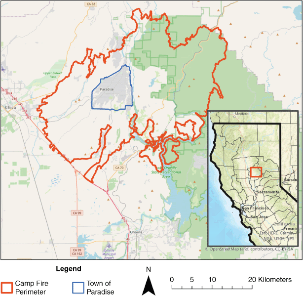
Occurring in November 2018, the Camp Fire was the deadliest and most destructive fire in California history in terms of lives and property lost. Over 60 000 hectares burned, with approximately 18 800 structures destroyed, over $16.5 billion in property damage, and at least 85 civilian fatalities. The fire was centered in and around the town of Paradise, CA, and included impacts in both the LRA and SRA (Fig. 1). Although much of the SRA had undergone extensive forest management, with 80 ongoing and completed fuel reduction projects in the County, thousands of acres of treated Forest Service land, and active thinning in nearby private forests, it has been observed that the fire’s speed and rate of ember casting rendered most treatments ineffective (Brown 2020).
|
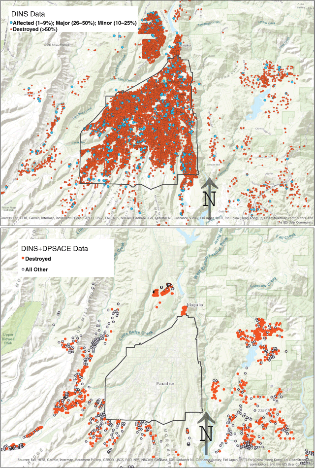
Two data sets were obtained for properties in the Camp Fire burn zone (Fig. 2). The first was Damage Inspection (DINS) data from the California Department of Forestry and Fire Protection (CAL FIRE), which aggregates information primarily about structures greater than $10 000 in value that were destroyed or damaged by wildfire. Most DINS data are collected only after an incident, using forensic methods to reconstruct the characteristics of structures and parcels before the fire, which introduces a significant possibility of collection error. The other problem with this data set was a lack of records representing totally undamaged structures, complicating statistical analysis of determinants of structure loss. Although DINS data does exist for undamaged properties in this area, records for these structures are lacking in most of the structural and lot attributes needed to conduct this analysis. In fact, the only attributes that exist for non-damaged properties in the DINS data set are year of construction and assessed improvement value. Therefore, we were unable to use the subset of DINS data for totally undamaged structures in our analysis, and instead used records for partially damaged structures to populate our category of non-destroyed structures.
|
The initial DINS data set consisted of 19 558 properties in both the SRA and LRA in and around Paradise. However, an analysis of the data revealed many duplicate records for the same address. It was determined that this was due to the fact that records existed for non-primary structures (e.g. outbuildings) on parcels that also had a record for the primary structure. Once these were filtered out, a total of 15 140 records remained. Of these, 14 518 were destroyed and 622 were partially or only slightly damaged. This is not an ideal ratio for use in a statistical analysis of binary outcomes, but the large sample size still yields sufficient statistical power. Our GIS assessment of the DINS data overlaid on high-resolution drone data captured just after the fire confirmed that the properties not included in this data set are almost entirely non-damaged (Fig. 3).

|
The second data set used was the combined DINS and defensible space inspection (DSPACE) data collected under CAL FIRE supervision, referred to here as DINS+DSPACE. This data set was much smaller, with only 1404 records, after filtering out duplicates (from repeat inspections) and several hundred unusable records with extensive null values. The data set only includes properties in the SRA (outside of the Paradise municipal boundary), but it has advantages over DINS in some respects: its ratio of destroyed to non-destroyed structures is almost even (728 destroyed to 676 not destroyed); data collection for it occurred before the fire (as opposed to forensic reconstruction used for DINS); it includes some totally undamaged structures (which were lumped with the ‘affected’ structures in forming the ‘non-destroyed’ category); and it contains attributes about yard fuels and their maintenance, based on a 14-point inspection for violations (although violations are only shown for less than 12% of total records). As with the DINS data, the DINS+DSPACE dataset only accounted for a small proportion (<5%) of the total number of undestroyed structures within its area of representation.
In summary, then, each data set has strengths and limitations. DINS’ far larger sample size gives it more statistical power and its inclusion of the built-up LRA core of Paradise is critical in terms of geographic representation, whereas DINS+DSPACE has better balance between destroyed and not destroyed, contains some undamaged structures, was collected before the fire, and has more attributes about vegetation and other fuels on the property.
Methods
Logistic regression was used to analyse both datasets (DINS and DINS+DSPACE), with a response value of ‘1’ representing a total structure loss and a value of ‘0’ representing a non-destroyed structure. In the DINS data set, all records with a zero value have partial damage. In the DINS+DSPACE data set, records with a zero value include both structures that were partially damaged and totally undamaged. Most predictor variables were originally included in the dataset as categorical variables that had to be recoded as binary ‘dummy’ variables. One predictor variable was generated from original GIS analysis: structure shape angularity, meant to quantify where a structure fell on the spectrum from a simple box to a footprint with many corners and angles. This was coded by dividing the square of the structure’s perimeter by its area. Many variables were tested for inclusion in our models using sequential multi-model selection, and all consistently non-significant variables were dropped. A list of variables tested and dropped for both data sets is provided in Table 1 and descriptive statistics for included variables are given in Table 2.

|

|
After running regressions, coefficients were exponentiated and odds ratios calculated, describing the probabilistic relationship between exposure and outcome. Models from the larger DINS database are denoted with ‘D’ and a model number (Table 1), and the one model presented from the combined DINS+DSPACE dataset is referred to as DD1.
A key methodological challenge to be addressed was the presence of many null values. Several hundred records had to be deleted from the DINS+DSPACE database because all structural values were null, rendering them unusable. However, for the DINS data, there were several thousand records where just one or a few attribute values were null. Among the fields in the DINS dataset with high numbers of null values were vegetation clearance (1900 null records), slope (2952), and year built (569). All other variables had fewer than 30 null records. Rather than discard all these records, we chose instead to compare a model where all null-containing records were filtered out against two other models with differing allowable thresholds of null-containing records. The first model had no nulls filtered (D1). For the records with null values, we assumed that a blank meant a value of ‘zero,’ which we felt was in the realm of possibility. The second had all records containing nulls filtered (D2). The third had all records with null values for vegetation clearance filtered (D3). There was a total of 3654 records with some null value across all variables.
One variable where nulls were treated differently was defensive action (DefAction), which Syphard and Keeley (2019) had found to be highly significant in predicting structure loss. In our DINS+SPACE dataset this column had a very high number of null (9583) and ‘unknown’ (9673) values, and all non-null or non-unknown records had a value of ‘yes,’ yielding only 1.5% of records with an affirmative response (i.e. defensive action occurred). When we ran regressions showing all 98.5% of the nulls/unknowns as zeros, this variable was still highly significant in the expected direction. We chose therefore to assume that null/unknown records received no defensive action and so did not filter any data based on this record.
Results
DINS models
Models D1-3 (Tables 3–5) indicated that structural hardness factors were especially important in the survival of structures. One key proxy indicator of structural hardness is whether the structure was built after the state’s fire safe building code updates were passed. As mentioned earlier, there were two such laws passed in 2005 and 2007, with the latter not implemented until 2008. Seeking to avoid overspecification, we tested which of the dates was more predictive. Our results indicated that the dummy variable for construction after 2007 was the more predictive of the two, with a higher coefficient and Wald statistic, so, in the interests of parsimony, it was included instead of the 2005 dummy variable, which shed little additional light. We additionally tested several other date range dummy variables and found that including one for construction between 1996 and 2007 was warranted in the model as well. Its coefficient was just slightly higher than that for 2007 in all D models (i.e. −1.001 for 1996–2007 vs −0.917 for 2007 under model D1, yielding 60 and 63% respective reductions in odds of destruction). This indicated that the marginal effect on loss probability was slightly less for the post-2007 date range, which was somewhat unexpected. The Wald statistic for the 1997–2007 variable was more than three times that of the 2007 dummy variable (i.e. 55.5 vs 14.7), indicating that the former is a more reliable predictor.

|

|

|
Assessed improvement value served as a proxy variable for structural hardness, given that more expensive structures tend to be higher quality in construction methods and materials. This variable was significant and negative in models D1 and D3, indicating a drop of between 0.4 and 0.5% in the odds of destruction for each $100 000 increment in value.
Other structural features that were associated with lower probability of loss in the D models include, in order of their marginal effects, (1) absence of attic/crawlspace vents, (2) enclosed eaves, (3) presence of double-paned windows, and (4) resistant siding. The signs of all these coefficients were as expected. The marginal effect for the highest of these, absence of attic/crawlspace vents, ranged from a 77% reduction in odds of destruction in models D2 and D3, to 74% in D1. The lowest of these marginal effects, for multi-pane windows, ranged from 23% in model D1 to 35% in Model D2. The odds changes for the other variables can be seen in Tables 3–5. In addition to having the highest coefficient, the variable for absence of attic/crawlspace vents also has by far the highest Wald statistics (96.36 in Model D1, compared with 65.2 for enclosed eaves, the next highest Wald statistic among structural variables).
Two structural variables were associated with an increased probability of destruction. The first, asphalt roofs, was associated with a 75% increase in odds of destruction in Model D1, and insignificant in Models D2 and D3. The second such variable indicated if the structure was a mobile home. This was the highest scoring structural variable in any of the DINS models, with an increase in odds of destruction ranging from 379% in Model D2 to 524% in Model D1, and Wald statistic values ranging from 57.5 in Model D2 to 105.7 in Model D1. Like age of construction, this is considered a composite metric because mobile home status represents a wide array of construction features and materials. The mobile home variable is therefore somewhat colinear with many other structural variables because this type of home tends to have lower quality construction.
Parcel factors were important too. As expected, the variable for sloped property (the minimum angle to be considered sloped is not given in the metadata but was based more on subjective measures) was consistently significant across models and indicated an increase in probability of destruction between 54% and 77%. The variable for attached fence (of any material) was significant and negative in all D models. The fact that it is negative is somewhat surprising given that many fences are made of wood. This may be an artifact of data quality or it may be that fencing provides an effective barrier against embers or even the fire line in some cases. Regardless, its effect ranged from a 24% to a 35% drop in odds. When we ran the model with the variable for combustible attached fence (rather than any fence), it was not significant. The variable for attached wood deck at grade was, as expected, positive, but was only significant in Model D1, showing a 31% increase in the probability of destruction.
A key parcel-level predictor addressed in this study and throughout the fire safety literature is defensible space clearance. Three mutually exclusive dummy variables for vegetative clearance were recorded for each property, representing clearance at the following intervals: (1) from 0–9.1 m from the structure; (2) from 9.1–30.5 m; and (3) greater than 30.5 m. The latter two variables, representing more aggressive defensible space clearance, are not significant in any model. The first, representing the lowest possible level of defensible space, is significant, with a positive coefficient indicating a 62% increase in odds of loss. In other words, our results only indicate a significant effect from the first (least clearance) interval, and its effect is to increase risk of destruction, which is as expected. We do not know from the data how many of the structures in this lowest interval have no clearance at all (i.e. vegetation up to the structure), but enough probably do to make this variable essentially a proxy for the existence of no or minimal defensible space. However, it is only significant in Model D1, suggesting that this result is not stable. Further, the fact that the variables for clearance at the 9.1–30.5 m and 30.5+ m intervals are not significant on their own when the variable for 0–9.1 m is not included (results not shown here) also suggests an inconclusive relationship between defensible space and structure loss in this particular data set.
Finally, for the D models, defensive action is highly predictive of structure survival, yielding the highest Wald statistic and coefficient of any variable in the models (D1: B = −4.29; W = 434.26; D2: B = −4.24, W = 358.26; D3: B = −4.34, W = 435.37), and resulting in a drop in odds of destruction of between 85% and 99%. This strong statistical signal indicated to us that this is an important variable and that it was warranted to keep it in despite the issue with null values.
DINS+DSPACE
Model DD1 (Table 6) resulted in fewer significant variables, likely because of the small sample size. Only two structure variables were significant: multi-pane windows, resulting in a decrease in odds of loss of 49%, and presence of a wood roof, resulting in a massive 539% increase in odds. As with the D models, structures that were mobile homes were more likely to be destroyed, although at a much smaller magnitude, with an increase to odds of loss of 41%. Several lot characteristics increased the chance of loss, including: (1) presence of elevated and at-grade wood decks (odds increased by 78 and 141% respectively); (2) presence of a combustible fence (odds increased by 64%); and (3) presence of water storage on the property (odds decreased by 32%). The risk increase associated with combustible fences contrasts with the risk reduction associated with the fence of any material variable for the D models, suggesting that the effects of fences may be too complex to model with simple dummy variables, or that there is an issue around post-fire data collection regarding fences. Year of structure construction was not included in these models because only 12% of records had values for this variable.

|
Only two of the vegetation management violation variables were found to be significant in this data set (see Table 1 for dropped variables): violation due to a failure to remove ‘leaves, needles or other vegetation on roofs, gutters, decks, porches and stairways, etc.’, and to ‘mow dead or dying grass to a maximum of 4 inches [10 cm] in height’ (California Department of Forestry and Fire Protection Notice of Fire Hazard Inspection Form, PRC §4291(a)(6) and PRC §4291(a)(1)). Results indicated that these violations were associated with an increase in odds of loss of 277 and 247% respectively.
The vegetative clearance distance variables from the D models were not available for this data set.
Discussion
Structural characteristics
Our results are consistent with those of Syphard and Keeley (2019) in finding that structural hardness characteristics are important in predicting building survival, at least in this type of extreme ‘mega fire’ event. Characteristics that limit ember penetration, such as multi-pane windows, ignition resistant siding, enclosed eaves, and lack of vents, appear to be of particular importance, which is consistent with the literature. The lack of crawlspace and attic vents is important because they can provide an access point for embers into attics, which are generally hot and dry (due to lack of climate control) and filled with combustible materials (Quarles et al. 2010). Many fire-safe building codes require at least mesh covers on vents, following the advice of the National Fire Protection Association. Interestingly, our results found that the presence of mesh-covered vents was not statistically significant in reducing risk of loss. Enclosed eaves, also known as ‘boxed in eaves,’ are somewhat more controversial in terms of their effectiveness. Some guidance suggests this type of eave construction is preferable to an open eave design (Slack 1999; FEMA 2008), but Quarles et al. (2010) highlighted that evidence to date of this superiority is largely anecdotal. The present study adds to the empirical evidence that the enclosed eave design may be superior to open eaves.
The importance of multi-pane windows is also well established, though it has been pointed out that the better performance of these windows may have more to do with the fact that they are more likely than single-paned windows to have tempered glass (California code requires that at least one pane be tempered), which is about four times stronger than regular glass (Quarles et al. 2010).
We do not know the exact siding type of structures in our data set that are classified as ignition resistant, but we do know that under California code such a classification requires a high level of resistance to flames in a test, and often includes materials such as multi-coat stucco, or metal and fiber cement, in addition to chemically treated wood products. Resistant siding plays a role by preventing easy ignition of siding followed by flame spreading up the wall to the more vulnerable soffits, eaves and vents. In other words, good siding keeps flame at bay from those areas most likely to allow penetration to the interior.
The role of roof material in mitigating or increasing fire risk has been the subject of great concern in building codes. Our DINS dataset included six types of roofs: asphalt, wood, tile concrete, metal and other. However, the D models only found the asphalt roof dummy variable to be significant, maybe because the vast majority (83%) of our records had asphalt roofs. Asphalt roofs were found to significantly increase the odds of structure loss. This was expected because, although asphalt roofs are a Class A fire-safe material, they are less safe than the other two major Class A types found in the database: metal and ceramic tile. This is because asphalt tiles will combust if exposed to fire for several hours given that they generally contain at least some wood products, unlike most other Class A roofing materials (FEMA 2008). As mentioned, this variable lost significance when run on the data sets filtered for nulls. Interestingly, the variable for asphalt roofing was not significant in the DD model, but the wood roof variable was, resulting in an increase in odds of destruction of over 500%. Attempts were made to code a single dummy variable for all combined ‘safe’ roof types in both data sets, but none was significant. Overall, then, although roofing material appears to be important in our analysis, the particulars remain relatively inconclusive compared with other structural factors.
Three variables likely serve as proxies for a wide range of structural characteristics: year of construction (built after 2007 or between 1996 and 2006), assessed improvement value, and mobile home. The first serves as a proxy because the later the construction, the more elements of fire-safe building codes the structure is likely to incorporate. The second does so because more expensive homes typically have higher quality building materials which have a higher likelihood of preventing ember penetration or otherwise igniting.
The third variable, mobile homes, is of clear importance given its outsized Wald statistics and odds impacts indicated by our D models. We have no way of knowing which characteristics of mobile homes make them more vulnerable from this data but some limited research in the past has proposed several possible causes for mobile home vulnerability to wildfire, including the ability for wildfire to run under the floor when not fitted with proper skirting, their unprotected sliding glass doors and picture windows, prevalence of attached carports and porch canopies or sundecks, and the close spacing in mobile home parks allowing quick structure-to-structure spread (Moore 1981). According to Moore’s study, not only are mobile homes more likely than other homes to be destroyed by wildfire, but they also yield a mortality rate that is several times that of stationary homes due to the flashy nature of interior spread in mobile units, the highly toxic and thick smoke their materials often produce when combusted, and the general lack of safe escape routes.
Lot characteristics
Parcel-level variables appear mostly consistent with guidance in the literature: buildings on sloped properties are more prone to destruction (significant in the D models, but not DD), and wood decks increase the odds of loss (significant for at-grade decks in both, but only for elevated in the DD model). Interpreting the results with respect to fences is difficult. In the D models, combustible fencing was not significant, but fencing of any kind was associated with reduced structure loss. This may be a statistical artifact due to data collection issues, or it may reflect the fact that fences, on average, can slow the progress of fires and wind-borne embers. The variable for combustible fences in the DD model was significant and associated with higher risk of structure loss, a finding consistent with the literature, which tends to classify fences as fuel (FEMA 2008).
Defensive action by firefighters was also found to be extremely important – in fact, more so than any other factor in the D models. This is despite the considerable uncertainty about how to handle the large number of blank values for this field. Although we do not know how accurate our interpretation of the response variable was, our findings are consistent with Syphard and Keeley (2019) in finding that this is an extremely predictive variable. We believe it should be studied further.
Of key policy and management importance is the question of defensible space and fuel management surrounding structures. This study fails to find a consistent and significant reduction in the risk of structure loss due to implementing defensible space actions on a parcel. Our D models found no indication that higher levels of defensive space, as indicated by the dummy variables for clearance at the 9.1–30.5 m and 30.5+ m intervals, are associated with better outcomes. We did find that the 0–9.1 m′ clearance interval, representing the lowest possible category for defensible space, was associated with an increased chance of loss, but only in the first, unfiltered model (D1). So not only is there a lack of agreement among models on defensible space, but the one model with a significant result merely indicates that membership in the lowest defensible space category is associated with more loss, not that more extensive defensible space clearance reduced the probability of loss. Interpretation of this already vague result is further confounded by the fact that it is impossible to say how many of the records in the 0–9.1 m clearance interval have no clearance at all (i.e. a distance of 0, or vegetation up to the structure) vs defensible space extending to the upper boundary of 9.1 m. Regardless, our results suggest that the 0–9.1 m-dummy variable is acting as a proxy for the existence of no or minimal defensible space.
Although defensible space results were inconclusive, results from the DD model suggests that other elements of yard maintenance matter. Failure to remove needles/leaves from surfaces immediately adjoining the structure (e.g. gutters, porches, roofs) increased the odds of destruction by 277%, and failure to mow dead grass within 9.1–30.5 m of the structure increased those odds by 247%. These are important findings, but the fact that only 3% of records were positive for these violations does somewhat limit the reliability of the result. Further, the lack of significance for the remaining 13 violation code variables adds even further uncertainty. To truly address the risks associated with the violations, a far bigger data set would be needed with many more recorded violations. In fact, only 12% of all records in this data had at least one violation, suggesting either that conditions that would lead to violation were minimal among these homes or that data on these characteristics was not fully collected for most homes. In either case this limits the utility of this data set for statistical analysis.
All of this suggests that evidence for defensible space’s effect on structure survival is limited in these data sets, even though logic and fire science suggest that a reduction of fuels through defensible space should make a nearby structure safer under a range of fire weather and fuel conditions. There are many possible reasons for this lack of a result. One is that because this was a ‘mega-fire’ environment, where fire resources were spread thin or focused on evacuations or maintaining crew safety, there was less direct structure protection activity occurring that could have utilised defensible space. Another is that structures of all types may have been exposed to extensive ember showers regardless of defensible space clearance. The nature of the two datasets, which included many inaccurate or incomplete records, may have been a factor too. The relative lack of records for undamaged properties with full data attribution may have resulted in a selection bias characterised by relative lack of observations with large amounts of defensible space in the data set. Also, the forensic estimation of pre-fire lot conditions for destroyed properties may have suffered from measurement errors, particularly for smaller trees, shrubs and grasses that were likely incinerated beyond recognition. This also may apply for structural attributes; due to the forensic nature of much of the data collection, it is very possible that many of the collected variables were not particularly accurate. Clearly, this calls out the need for pre-fire inspections of property, of which the DD dataset was an example.
The lack of results on defensible space, however, may also relate to the specific nature of the Camp Fire. Perhaps, the Camp Fire’s behaviour was so intense that ember casting and house-to-house transmission overwhelmed the effect of the reductions in proximate fuel loads (and associated convective heating) provided by defensible space. If ember showers were the primary means of transmission, then it would make sense that defensible space would have relatively little impact on structure survival because the defensible space zone is typically not the main source of embers. Further, the extreme nature of this event may have negated the role that defensible space typically plays in providing conditions needed for fire crews to protect homes. These types of questions can only be answered by looking comparatively at the outcomes of different fire events.
Moving forward, ramping up the quantity and quality of data will be valuable in answering questions about the effects of both structure characteristics and defensible space. Ultimately, more and better data mean a greater ability to predict how structures will fare in the next wildfire event. Such information will be critical to writing the next generation of fire-safe building codes and lot standards.
Conclusion
The Camp Fire was one of the most intense and destructive fires in U.S. history, yet many structures survived. This study statistically analysed data on loss and property characteristics to try to better understand the determinants of structural survival. Although our findings are not entirely consistent between the two data sets we analysed, overall, we found that that structural hardness factors, such as the presence of fire-resistant siding and roofing and double paned windows, and the absence of entry points like uncovered vents, are very important determinants. Year of construction was also an important predictor. Relatively newer structures, including those built after California’s 2007 fire-safe building code updates as well as those built in the decade prior experienced lower rates of destruction. Defensive action by fire fighters was also found to be extremely important – in fact, more so than any other factor. Various lot-level factors were important too, but the role of defensible space in preventing structure loss was inconclusive from these data sets.
Data availability
Camp fire damage inspection data can be viewed at: https://CAL FIRE-forestry.maps.arcgis.com/apps/webappviewer/index.html?id=5306cc8cf38c4252830a38d467d33728.
Conflicts of interest
The authors declare no conflicts of interest.
Declaration of funding
This research was conducted as part of a funded services contract that Spatial Informatics Group had with California Department of Forestry and Fire Protection (CAL FIRE).
Acknowledgements
This work was made possible by a contract funded by California Department of Forestry and Fire Protection (CAL FIRE). We would like to acknowledge the many people at CAL FIRE who assisted with this research and the interpretation of data.
References
Agee JK, Bahro B, Finney MA, Omi PN, Sapsis DB, Skinner CN, van Wagtendonk JW, Phillip Weatherspoon C (2000) The use of shaded fuelbreaks in landscape fire management. Forest Ecology and Management 127, 55–66.| The use of shaded fuelbreaks in landscape fire management.Crossref | GoogleScholarGoogle Scholar |
Alexandre PM, Stewart SI, Mockrin MH, Keuler NS, Syphard AD, Bar-Massada A, Clayton MK, Radeloff VC (2016) The relative impacts of vegetation, topography and spatial arrangement on building loss to wildfires in case studies of California and Colorado. Landscape Ecology 31, 415–430.
| The relative impacts of vegetation, topography and spatial arrangement on building loss to wildfires in case studies of California and Colorado.Crossref | GoogleScholarGoogle Scholar |
Baylis P, Boomhower J (2021) Building codes and community resilience to natural disasters. Working Paper, University of British Columbia, Vancouver, BC, Canada.
Braziunas KH, Seidl R, Rammer W, Turner MG (2021) Can we manage a future with more fire? Effectiveness of defensible space treatment depends on housing amount and configuration. Landscape Ecology 36, 309–330.
| Can we manage a future with more fire? Effectiveness of defensible space treatment depends on housing amount and configuration.Crossref | GoogleScholarGoogle Scholar |
Brown H (2020) The Camp Fire Tragedy of 2018 in California. Fire Management Today 78, 11–21.
Cohen JD (2000) Preventing disaster: home ignitability in the wildland–urban interface. Journal of Forestry 98, 15–21.
| Preventing disaster: home ignitability in the wildland–urban interface.Crossref | GoogleScholarGoogle Scholar |
Cohen JD, Stratton RD (2008) Home destruction examination: Grass Valley Fire, Lake Arrowhead, California. Technical Paper R5-TP-026b. US Department of Agriculture, Forest Service, Pacific Southwest Region (Region 5), Vallejo, CA, USA. https://www.fs.usda.gov/treesearch/pubs/31544
FEMA (2008) Home builder’s guide to construction wildfire zones. Technical Fact Sheet Series P-737. Federal Emergency Management Agency, US Department of Homeland Security, Washington, DC, USA.
Finney MA, Seli RC, McHugh CW, Ager AA, Bahro B, Agee JK, Finney MA, Seli RC, McHugh CW, Ager AA, Bahro B, Agee JK (2007) Simulation of long-term landscape-level fuel treatment effects on large wildfires. International Journal of Wildland Fire 16, 712–727.
| Simulation of long-term landscape-level fuel treatment effects on large wildfires.Crossref | GoogleScholarGoogle Scholar |
Finney MA, Cohen JD, Grenfell IC, Yedinak KM (2010) An examination of fire spread thresholds in discontinuous fuel beds. International Journal of Wildland Fire 19, 163–170.
| An examination of fire spread thresholds in discontinuous fuel beds.Crossref | GoogleScholarGoogle Scholar |
Gibbons P, van Bommel L, Gill AM, Cary GJ, Driscoll DA, Bradstock RA, Knight E, Moritz MA, Stephens SL, Lindenmayer DB (2012) Land management practices associated with house loss in wildfires. PLOS ONE 7, e29212
| Land management practices associated with house loss in wildfires.Crossref | GoogleScholarGoogle Scholar | 22279530PubMed |
Haire SL, McGarigal K (2009) Changes in fire severity across gradients of climate, fire size, and topography: a landscape ecological perspective. Fire Ecology 5, 86–103.
| Changes in fire severity across gradients of climate, fire size, and topography: a landscape ecological perspective.Crossref | GoogleScholarGoogle Scholar |
Knapp EE, Valachovic YS, Quarles SL, Johnson NG (2021) Housing arrangement and vegetation factors associated with single-family home survival in the 2018 Camp Fire, California. Fire Ecology 17, 25
| Housing arrangement and vegetation factors associated with single-family home survival in the 2018 Camp Fire, California.Crossref | GoogleScholarGoogle Scholar |
Moore HE (1981) Protecting residences from wildfires: a guide for homeowners, lawmakers, and planners. General Technical Report PSW-GTR-050. US Department of Agriculture, Forest Service, Pacific Southwest Forest and Range Experiment Station, Berkeley, CA, USA.
Penman SH, Price OF, Penman TD, Bradstock RA (2019) The role of defensible space on the likelihood of house impact from wildfires in forested landscapes of south eastern Australia. International Journal of Wildland Fire 28, 4–14.
| The role of defensible space on the likelihood of house impact from wildfires in forested landscapes of south eastern Australia.Crossref | GoogleScholarGoogle Scholar |
Quarles SL, Valachovic Y, Nakamura GM, Nader GA, De Lasaux MJ (2010) Home survival in wildfire-prone areas: building materials and design considerations. Agriculture and Natural Resources Publication 8393. University of California, Davis, CA, USA.
Radeloff VC, Helmers DP, Kramer HA, Mockrin MH, Alexandre PM, Bar-Massada A, Butsic V, Hawbaker TJ, Martinuzzi S, Syphard AD (2018) Rapid growth of the US wildland–urban interface raises wildfire risk. Proceedings of the National Academy of Sciences 115, 3314–3319.
| Rapid growth of the US wildland–urban interface raises wildfire risk.Crossref | GoogleScholarGoogle Scholar |
Schmidt J (2020) Vegetation cover and structure loss in four northern California wildfires: Butte, Tubbs, Carr, and Camp. Munich Personal RePEc Archive Paper No. 104232.
Slack P (1999) ‘Firewise Construction: Design and Materials.’ (Colorado State Forest Service: Fort Collins, CO, USA)
Syphard AD, Keeley JE (2019) Factors associated with structure loss in the 2013–2018 California wildfires. Fire 2, 49
| Factors associated with structure loss in the 2013–2018 California wildfires.Crossref | GoogleScholarGoogle Scholar |
Syphard AD, Brennan TJ, Keeley JE (2014) The role of defensible space for residential structure protection during wildfires. International Journal of Wildland Fire 23, 1165–1175.
| The role of defensible space for residential structure protection during wildfires.Crossref | GoogleScholarGoogle Scholar |
Syphard AD, Brennan TJ, Keeley JE (2017) The importance of building construction materials relative to other factors affecting structure survival during wildfire. International Journal of Disaster Risk Reduction 21, 140–147.
| The importance of building construction materials relative to other factors affecting structure survival during wildfire.Crossref | GoogleScholarGoogle Scholar |
Syphard AD, Rustigian-Romsos H, Keeley JE (2021) Multiple-scale relationships between vegetation, the wildland–urban interface, and structure loss to wildfire in California. Fire 4, 12
| Multiple-scale relationships between vegetation, the wildland–urban interface, and structure loss to wildfire in California.Crossref | GoogleScholarGoogle Scholar |