

Using soil moisture information to better understand and predict wildfire danger: a review of recent developments and outstanding questions
Erik S. Krueger A * , Matthew R. Levi B , Kevin O. Achieng B I , John D. Bolten C , J. D. Carlson D , Nicholas C. Coops E , Zachary A. Holden F , Brian I. Magi G , Angela J. Rigden H H and Tyson E. Ochsner A
A Plant and Soil Sciences, Oklahoma State University, Stillwater, Oklahoma, USA.
B Crop and Soil Sciences, University of Georgia, Athens, Georgia, USA.
C NASA Goddard Space Flight Center, Greenbelt, Maryland, USA.
D Biosystems and Agricultural Engineering, Oklahoma State University, Stillwater, Oklahoma, USA.
E Faculty of Forestry, University of British Columbia, Vancouver, British Columbia, Canada.
F United States Forest Service, Missoula, Montana, USA.
G Geography and Earth Sciences, University of North Carolina Charlotte, Charlotte, North Carolina, USA.
H Earth System Science, University of California, Irvine, USA, Irvine, California, USA.
I Present address: Department of Civil Engineering, DedanKimathi University of Technology, Private Bag 10143, Nyeri, Kenya.
International Journal of Wildland Fire 32(2) 111-132 https://doi.org/10.1071/WF22056
Submitted: 21 April 2022 Accepted: 21 October 2022 Published: 5 December 2022
© 2023 The Author(s) (or their employer(s)). Published by CSIRO Publishing on behalf of IAWF. This is an open access article distributed under the Creative Commons Attribution 4.0 International License (CC BY).
Abstract
Soil moisture conditions are represented in fire danger rating systems mainly through simple drought indices based on meteorological variables, even though better sources of soil moisture information are increasingly available. This review summarises a growing body of evidence indicating that greater use of in situ, remotely sensed, and modelled soil moisture information in fire danger rating systems could lead to better estimates of dynamic live and dead herbaceous fuel loads, more accurate live and dead fuel moisture predictions, earlier warning of wildfire danger, and better forecasts of wildfire occurrence and size. Potential uses of soil moisture information in existing wildfire danger rating systems include (1) as a supplement or replacement for drought indices, (2) for live and (3) dead fuel moisture modelling, (4) for estimating herbaceous fuel curing, and (5) for estimating fuel loads. We identify key remaining research questions and note the logistical challenge of convincing wildfire professionals of the importance of soil moisture compared with more familiar wildfire danger metrics. While obstacles remain, the path forward is clear. Soil moisture information can and should be used to improve fire danger rating systems and contribute to more effective fire management for the protection of communities and ecosystems worldwide.
Keywords: fuel properties, in situ, modelling, remote sensing, review, soil moisture, wildfire, wildfire danger index, wildfire danger rating systems.
Introduction
At 6:33 am on the morning of 8 November 2018, a small fire was reported under electrical power lines near Camp Creek Road outside the town of Pulga in northern California, USA. Dry conditions and strong downslope winds with gusts >25 m s−1 (Brewer and Clements 2020) rapidly transformed that small fire into the deadliest and most costly wildfire in California’s history. The Camp Fire burned >62 000 ha, destroyed >18 000 structures, and resulted in 85 fatalities (California Department of Forestry and Fire Protection 2019). This tragedy powerfully illustrates the importance of fire danger rating systems and the need to provide earlier and more accurate warnings for fire management agencies and the public. Toward that end, this review explores recent developments, knowledge gaps, and challenges in applying previously underutilised soil moisture information to better understand, assess, and predict wildfire danger. Up until now, the incorporation of soil moisture information into existing fire danger rating systems has been limited to simplistic models or drought indices that use standard weather variables to estimate soil moisture, even though better information is becoming increasingly available via in situ measurements, remote sensing, and more sophisticated modelling. One week prior to the tragic Camp Fire, for example, satellite observations showed strong negative soil moisture anomalies across northern California (Fig. 1), conditions that are known to substantially increase the probability of large wildfires (Krueger et al. 2015, 2016; Sazib et al. 2022), but the tools needed to effectively put this information into action are currently lacking.

|
It is not a recent revelation that soil moisture conditions are important for fire danger rating. Prominent fire danger rating systems in Canada, Australia, and the United States each use approximations of the moisture of mineral and/or organic soil horizons to quantify wildfire danger (Kumar and Dharssi 2015). For example, the Canadian Forest Fire Danger Rating System (CFFDRS) (Stocks et al. 1989; Wotton 2009) includes three moisture indices, termed moisture codes, to represent moisture stored in the organic layers of the forest floor. The Fine Fuel Moisture Code (FFMC) represents fuel moisture of fine surface litter with a depth of 10–20 mm, the Duff Moisture Code (DMC) represents fuel moisture of loosely compacted duff with a depth of about 50–100 mm, and the Drought Code (DC) represents fuel moisture of deep organic materials having a depth of about 100–200 mm (de Groot 1987) (Fig. 2). While intended to represent moisture of surface organic layers, DMC and DC are strongly correlated with soil moisture of mineral horizons near the surface (Pellizzaro et al. 2007; D’Orangeville et al. 2016), likely in part because of capillary and vapour flow between mineral and organic soil layers (Zhao et al. 2022). When considering soils with deep organic layers at the surface, i.e. deep O horizons in soil science terminology, the water stored in those layers may be viewed as either soil moisture or fuel moisture because the organic layer itself can become combustible at low water contents.
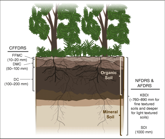
|
In the recently modified Australian Fire Danger Rating System (AFDRS, Matthews 2022), fire danger ratings for dry eucalypt forests are dependent in part on soil moisture deficit estimated using the Keetch–Byram Drought Index (KBDI, Keetch and Byram 1968). The KBDI uses temperature and precipitation data to estimate the soil moisture deficit in the upper soil layers (mineral and organic, if present) using a water balance approach. The KBDI was designed to represent the moisture deficit in approximately the top 760–890 mm for a fine-textured soil and greater depths for coarser-textured soils (Keetch and Byram 1968) (Fig. 2). Similarly, in the National Fire Danger Rating System (NFDRS) used in the United States (Deeming et al. 1972; Bradshaw et al. 1983; Burgan 1988; Jolly 2018), KBDI helps determine fire danger ratings through its influence on dead fuel load. The inclusion of these moisture indices in widely used fire danger rating systems makes it clear that their developers recognised the importance of soil moisture for understanding wildfire danger. However, at the time these systems were developed, large-scale soil moisture measurement systems and physically-based hydrologic models were not sufficiently developed. Instead, meteorological observations from existing weather stations were used to calculate soil moisture indices. Given advances in soil moisture measurement and modelling systems in recent decades, there is a need to reassess how to best represent the moisture conditions of organic and mineral soil layers in fire danger rating systems and to better understand the effects of those conditions on fire danger.
The effectiveness of fire danger rating systems can be determined through retrospective analyses of the relationship between fire danger ratings and important wildfire metrics including occurrence and size. For example, a recent analysis of the NFDRS showed generally positive correlations between fire danger ratings and fire sizes across the contiguous US, but there were important spatial inconsistencies. Notably, there was poorer performance in the eastern half of the country compared to the western half, possibly due to regional differences in soil–vegetation–climate interactions and in the timing and length of the fire season (Walding et al. 2018). Furthermore, large areas in the central US lacked the necessary data to generate fire danger ratings because those areas contained only a limited number of designated reporting stations for the Weather Information Management System, which provides weather data for the NFDRS (Walding et al. 2018). Thus, improvements to the NFDRS will likely need to consider both model structural improvements, as well as new and better sources and types of input data. Currently, the NFDRS and most other fire danger rating systems in use around the world rely on a relatively standard set of input variables that are routinely measured at weather stations, chief among them being air temperature, relative humidity, precipitation, and wind speed (de Groot et al. 2015), as well as the aforementioned simplistic moisture indices derived from these measurements.
A major hindrance to the integration of improved sources of soil moisture information into fire danger rating systems has been the inadequate duration and spatial extent of those sources. That situation is rapidly changing as a variety of new sources of soil moisture information are becoming available, each with unique strengths (Fig. 3). These new data sources include (1) soil moisture measured in situ, (2) soil moisture measured remotely by satellites, and (3) soil moisture data that are generated using physically-based models. This groundswell of information began with the advent of state and national automated soil moisture monitoring networks in the US in the late 1990s and the subsequent emergence of similar networks in other countries around the world (Dorigo et al. 2021). In parallel, satellite missions capable of monitoring soil moisture and closely-related variables have been developed and launched by NASA and other space agencies, with substantial increases in daily coverage of the Earth’s surface since the late 1990s (Karthikeyan et al. 2017). These advances in soil moisture measurements have occurred alongside advances in numerical models, which can now provide soil moisture estimates for large domains with sub-kilometre resolution (Holden et al. 2019). Using these three types of soil moisture information, researchers began to generate first glimpses of the strong relationships between wildfire and in situ soil moisture (Krueger et al. 2015), remotely-sensed soil moisture (Bartsch et al. 2009), and modelled soil moisture (Slocum et al. 2010) (Table 1). Further studies have provided new insights into the relationships between soil moisture and fuel characteristics including fuel loads (e.g. Ellsworth et al. 2013; Sharma et al. 2018), curing (e.g. Wittich 2011; Sharma et al. 2021), and live (e.g. Bianchi and Defossé 2015; Fan et al. 2018) and dead fuel moisture (e.g. Masinda et al. 2021; Rakhmatulina et al. 2021). Other studies have directly related soil moisture to fire occurrence (Jensen et al. 2018; Ambadan et al. 2020) and fire size (e.g. Slocum et al. 2010; Forkel et al. 2012; Krueger et al. 2015), while still others have identified the impact of vegetation type on soil moisture–wildfire relationships (e.g. Schaefer and Magi 2019; Rigden et al. 2020). These and other important contributions (Table 1) to our understanding of soil moisture–wildfire relationships have emerged across a wide variety of scientific disciplines, which often are not well-connected, making the accelerating progress difficult to track and synthesise.

|

|
A further roadblock complicating the use of soil moisture information for fire danger ratings is that soil moisture conditions can be expressed in a variety of ways, making it more difficult to compare results across studies. For example, soil moisture can be expressed simply as soil volumetric water content (e.g. Schaefer and Magi 2019; Ambadan et al. 2020; Vinodkumar et al. 2021) or water content summed over some soil depth, i.e. soil water storage (e.g. Slocum et al. 2010; Krawchuk and Moritz 2011; Chikamoto et al. 2015). Alternatively, soil moisture can be formulated to represent the amount of soil moisture available to plants (Krueger et al. 2019), and it may also be normalised to allow for comparison across sites or across different soil moisture metrics. This normalisation procedure may be based on the physical properties of the soil (e.g. Krueger et al. 2015; Waring and Coops 2016; Vinodkumar et al. 2017) or use statistical techniques (Lyons et al. 2021). To further complicate the situation, soil moisture may be expressed across different soil depths (Fan et al. 2018; Vinodkumar et al. 2021) and as absolute values or anomalies (O et al. 2020; Sazib et al. 2022). These varied formulations of soil moisture may have inadvertently prevented its widespread use and obscured the growing body of literature establishing the important relationships between soil moisture and wildfire.
Therefore, our objectives are to (1) summarise the rapidly growing body of research on soil moisture–wildfire relationships, (2) broaden the community of researchers aware of and engaged in this line of research, and (3) make a convincing case for more widespread use of soil moisture information in operational fire danger rating systems. This review is organised into four primary sections. The first three sections summarise what is known about the relationships of wildfire and fuel bed properties to (1) in situ soil moisture measurements, (2) remotely sensed soil moisture, and (3) modelled soil moisture. The fourth section explains potential links between soil moisture information and existing fire danger rating systems, using NFDRS as one specific example. We conclude by describing primary challenges and opportunities for using soil moisture information to better understand and predict wildfire danger, including the identification of key areas of needed future research.
In situ soil moisture measurements
In situ soil moisture measurements are the gold standard of soil moisture information (Levi et al. 2019) against which remote sensing and modelled soil moisture values are evaluated (Fig. 3). In some geographic areas, in situ soil moisture data are available at sufficient spatial and temporal resolutions to inform wildfire management. The International Soil Moisture Network (ISMN) houses publicly available data from nearly 2700 in situ soil moisture monitoring stations across 65 networks worldwide, a number that is steadily growing (Dorigo et al. 2021). The United States has an especially prolific collection of in situ soil moisture monitoring networks, and the ongoing National Coordinated Soil Moisture Monitoring Network (NCSMMN) initiative aims to produced harmonised data products from in situ soil moisture measurements from approximately 2000 sites across the nation (Cosh et al. 2021). One of the longest running and densest large-scale soil moisture monitoring networks in the US, and in the world, is the Oklahoma Mesonet (McPherson et al. 2007; Ochsner et al. 2013). Oklahoma is also consistently among the top 10 states in the US for wildfire risk (III 2021); accordingly, data from Oklahoma have proven valuable for understanding soil moisture–wildfire relationships.
A striking example of the connections between soil moisture, fuel bed properties, and wildfire comes from the Marena, Oklahoma, In Situ Sensor Testbed (MOISST) located in north-central Oklahoma. The MOISST site was established in 2010 to compare in situ soil moisture sensing technologies (Cosh et al. 2016) and measure vegetation dynamics in tallgrass prairie (PhenoCam 2021), with fuel bed properties repeatedly measured at and around the site (Sharma et al. 2018). PhenoCam images collected at the site showed markedly different vegetation conditions during August of 2012 and 2013 (Fig. 4). Drought conditions for May–July 2012 resulted in a fuel moisture content for mixed live and dead fuels of only 27% in early August when the photo in Fig. 4a was taken. The severity of the drought was reflected in the measured soil moisture, expressed as fraction of available water capacity (FAW). FAW is a calculated measure of plant-available water based on measured volumetric water content and the available water capacity of the soil (Krueger et al. 2015), and it can be determined for any landscape (e.g. grassland, forest, and cropland) for which these variables are known. It is defined as the ratio of measured plant available water to the maximum plant available water capacity of the soil, and it typically ranges from 0 (no plant available water) to 1 (maximum plant available water). During May–July 2012, FAW averaged only 0.23 (i.e. plant available water was at 23% of its possible maximum), levels indicative of severe drought (Sridhar et al. 2008). In contrast, FAW averaged 0.82 (i.e. 82% of possible maximum) over the same period in 2013, which corresponded with green vegetation in August 2013 (Fig. 4b) and a mixed fuel moisture content of 101%. The low fuel moisture contents in August 2012 contributed to extreme wildfire danger and the devastating Freedom Hill Fire, which ignited approximately 80 km east of the MOISST site the same day the photo was taken. This fire burned nearly 24 000 ha of mostly shrubland and forest over a 2-week period, destroyed more than 300 homes, and resulted in Federal Emergency Management Agency assistance claims totalling more than US$7 million.

|
The qualitative soil moisture–fuel bed relationships that are clear in Fig. 4, and may be intuitive to fire managers, have been described in detail by recent research based on in situ soil moisture measurements. The soil moisture–fuel moisture relationship was quantified for various shrub species in Italy by Pellizzaro et al. (2007), who found that soil moisture was a better predictor of live fuel moisture than weather variables or weather-derived drought indices. Their finding was corroborated by Qi et al. (2012), who found that soil moisture explained 66% of the variability in live fuel moisture for oak and sagebrush in northern Utah, and soil moisture was more strongly correlated with live fuel moisture than were remotely sensed vegetation indices. Similar linear relationships between soil moisture and fuel moisture have also been reported for grassland fuels in South Africa (McGranahan et al. 2016).
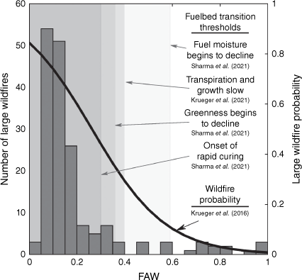
These findings have been corroborated by a series of studies in Oklahoma, the key results of which are summarised in Fig. 5. Sharma et al. (2021), using data from a grassland field study close to the MOISST site, reported that when soil moisture was plentiful (FAW values of at least 0.59), mixed fuel moisture was not related to soil moisture, but it declined as FAW decreased below this threshold. When FAW dropped below 0.40, the transpiration and growth rate of grassland live fuels declined, reflecting the intensification of drought stress (Krueger et al. 2021). When FAW declined below 0.36, the greenness of the vegetation, as indicated by the normalised difference vegetation index (NDVI), began to decrease (Sharma et al. 2021) (Fig. 5). At a still lower FAW threshold of 0.30, the transition of live fuel to dead (i.e. curing rate) increased rapidly, from near 0 g m−2 day−1 for FAW > 0.30 to more than 10 g m−2 day−1 as FAW approached 0.20 (Sharma et al. 2021). This drought-induced curing is vividly depicted in Fig. 4, with extremely low soil moisture corresponding with vegetation that was almost completely cured by early August 2012, while little curing had occurred by the same time in 2013 when soil moisture was plentiful. A perhaps subtler distinction in fuel bed characteristics between these years is that the live fuel load in 2013 was more than double that in 2012, which portended potentially high wildfire activity if dry and windy conditions prevailed during the subsequent dormant season. These findings offer a physical explanation for the observed dependence of growing season wildfire size and probability on soil moisture conditions (Fig. 5).
|
In a different study that used in situ soil moisture data from the entire state of Oklahoma, Krueger et al. (2015) showed that 90% of large growing season wildfires across all Oklahoma landscapes (forest, shrubland, and grassland) occurred for FAW < 0.40, which matches the threshold for transpiration reduction due to moisture stress in grassland vegetation (Krueger et al. 2021). These soil moisture–wildfire relationships were further described using probabilistic models in a subsequent study (Krueger et al. 2016). When plant available soil moisture was near its maximum, the probability of a large growing season wildfire across all Oklahoma landscapes was near zero even when temperature, wind speed, and relative humidity conditions were ripe for wildfires (Fig. 4 and Krueger et al. 2016). As FAW decreased to 0.59, the soil moisture threshold below which grassland fuel moisture decreased, wildfire probability increased to 0.10, and for a FAW value of 0.30, the threshold for rapid fuel curing, wildfire probability more than tripled to 0.44 (Fig. 5). These results suggest that soil moisture and weather conditions work in concert to support high growing season wildfire probability. Low soil moisture is associated with decreased fuel moisture and accelerated curing, while high temperatures, low relative humidity, and high wind speed facilitate fire ignition and spread.
When vegetation is dormant, however, current FAW levels were not a strong predictor of the probability of large wildfires in Oklahoma (Krueger et al. 2016), which may be related to the fact that dead fuel moisture content across most Oklahoma landscapes is not strongly dependent on soil moisture (Sharma et al. 2021). However, dormant season wildfire probability was increased by high soil moisture during the previous growing season. For example, when FAW during the growing season was at least 0.40, the probability of a large wildfire during the subsequent dormant season was approximately double compared with growing season FAW values near 0.20 (Krueger et al. 2016). Vegetation productivity, at least for Oklahoma grasslands, is maximised when FAW is >0.40 (Krueger et al. 2021), contributing to increased fine fuel loads in the subsequent dormant season.
Although there is a lack of evidence for soil moisture effects on dead fuel moisture in grasslands, in situ measurements from a diverse array of sites around the world reveal important links between soil moisture and dead fuel moisture for surface fuels in forests. In Australia, the influence of soil moisture on the fuel moisture content of fine dead fuels (i.e. leaf litter) was observed in plantations of Monterey pine approximately three decades ago (Pook and Gill 1993). The fuel moisture content for the pine needle litter on the surface was positively correlated with measured soil moisture in the 0–40 cm soil layer, and the correlation was stronger for un-thinned and un-pruned stands (r = 0.91) than in thinned and pruned stands (r = 0.45). The fuel moisture content of the surface leaf litter was predicted more accurately when soil moisture data were included along with temperature and humidity data in a multiple regression model compared to a similar model without soil moisture data.
More recently in Australia, in situ soil moisture measurements have been linked to the fuel moisture content of the surface and subsurface litter layer under various eucalyptus species (Zhao et al. 2021). A follow-up experiment showed that dry soil had a limited influence on the fuel moisture content of the litter, primarily through vapour flow between the soil and the litter (Zhao et al. 2022). In contrast, wet soil had a stronger influence on litter moisture content, with evidence for both vapour and capillary flow between the soil and the litter. Similarly, in situ measurements from forested sites in the foothills of the Sierra Nevada in central California showed that soil moisture had a stronger influence than any other environmental or meteorological factor on the fuel moisture of 10-h fuels (6–25 mm diameter dead fuels) for wet soil conditions (Rakhmatulina et al. 2021). A dominant influence of soil moisture on the moisture content of dead fine fuels was also documented through in situ measurements in Korean pine and Scots pine stands in northeastern China (Masinda et al. 2021). These reports of the connection between moisture of mineral soils and that of overlying organic layers corroborate previous studies correlating soil moisture measurements with moisture codes from the CFFDRS. For example, correlation coefficients of 0.6–0.8 were reported between measured soil moisture and soil moisture estimated from the DC index in Canadian forests (D’Orangeville et al. 2016).
These findings from diverse ecosystems and geographies highlight the dependencies of fuel loads, fuel moisture content, and wildfire probability on soil moisture. They have also laid the groundwork for a new generation of wildfire danger assessment tools that use in situ soil moisture information. However, even with expanding national- and regional-scale soil moisture monitoring networks, using in situ data for wildfire danger monitoring and management decisions is still constrained by the limited number of measurement sites in some locations, e.g. boreal forest, and most of South America, Africa, and Australia (Dorigo et al. 2021). Because soil moisture can vary greatly across even small distances (Famiglietti et al. 2008), point measurements of soil moisture are not necessarily representative of soil moisture at the landscape scale (Fig. 3). Finally, these datasets are often of limited duration, generally spanning less than 20 years (Cosh et al. 2021; Dorigo et al. 2021), which can make it challenging to use them for soil moisture–wildfire modelling. Therefore, there is a clear need for supplemental strategies for quantifying soil moisture, which include remotely sensed and modelled soil moisture information.
Remotely sensed soil moisture
Remote sensing technology has advanced rapidly since the first photograph of Earth was taken from space in 1946. Since that time, improvements in sensor fidelity, satellite and rocket launch technology, data storage, and aperture development have enabled many new capabilities, including near-real-time operations related to earth sciences and hydrology (McCabe et al. 2017). The ability to characterise the land surface using strategic regions of the electromagnetic spectrum has resulted in opportunities to remotely monitor and assess near-surface soil moisture and vegetation dynamics (Kumar et al. 2020; Mladenova et al. 2020), which are key to understanding the risks and impacts of wildfires. With the advent of refined satellite-based microwave sensors such as the European Space Agency’s Soil Moisture Ocean Salinity (SMOS) mission, which launched in 2009 (Kerr et al. 2010), and NASA’s Soil Moisture Active-Passive (SMAP) mission (Entekhabi et al. 2010), which launched in 2015, evidence is beginning to emerge that satellite-based soil moisture data can provide value for understanding and predicting wildfire danger in many ecosystems (O et al. 2020).
Remotely-sensed soil moisture data have proven useful for assessing fuel bed properties including biomass accumulation (i.e. fuel production) and fuel moisture content. For example, in southern France, live fuel moisture measurements for Mediterranean shrub species were significantly correlated with the preceding 15-day average remotely sensed soil moisture from the European Space Agency’s Climate Change Initiative Soil Moisture dataset (ESA CCI SM, formerly known as ESV SM) (Fan et al. 2018). A subsequent study used soil moisture data from SMAP to estimate live fuel moisture of chamise at 12 chaparral sites in southern California (Jia et al. 2019). At those sites, a statistical model using weighted, accumulative soil moisture and growing degree days outperformed models using vegetation optical depth or other optical indices. There is also some evidence that remotely sensed soil moisture might be useful for estimating dead fuel moisture. Burapapol and Nagasawa (2016) reported that remotely sensed soil moisture based on Landsat and MODIS was closely linked with fuel moisture of dead leaves in dipterocarp and deciduous forests in Thailand. Soil moisture based on microwave remote sensing may be preferable to optical reflectance indices commonly used to characterise fuel moisture [see reviews by Gale et al. (2021), Yebra et al. (2013), and Arroyo et al. (2008)] because microwave sensors are less prone to disturbances from unfavourable weather (e.g. clouds) and because soil moisture is physiologically linked to plant processes (Nolan et al. 2020).
The results of the above regional studies (Fan et al. 2018; Jia et al. 2019) were supported by a nationwide analysis of the ESA CCI SM data and live fuel moisture at >1000 sites across the contiguous US (Lu and Wei 2021). That analysis spanned numerous vegetation types and climate zones and revealed that the correlations between soil moisture and live fuel moisture were typically strongest when soil moisture was measured 10–50 days in advance. Important vegetation types showing a relatively high sensitivity to soil moisture included pine, red cedar, sagebrush, oak, manzanita, chamise, mesquite, and juniper. The SMAP Level-4 surface and root zone soil moisture products, which result from assimilation of SMAP observations into a land surface model, and in situ soil moisture measurements at selected sites both showed somewhat stronger correlations with live fuel moisture than did the ESA CCI SM data.
The links between remotely sensed soil moisture data and fuel bed characteristics make those data useful for assessing wildfire danger. For example, positive soil moisture anomalies observed by Earth Resources Satellite 1 and 2 corresponded with a lower burned area of forest fires in the boreal forest of Siberia (Bartsch et al. 2009). Furthermore, extreme fire events in this region were more closely associated with remotely sensed soil moisture [AMSR-E (Njoku et al. 2003)] than precipitation anomalies or fire danger indices (Forkel et al. 2012). More recently, SMOS observations over boreal forest areas of Canada revealed that wildfires occurred more frequently in anomalously low soil moisture conditions (Ambadan et al. 2020). At more southerly latitudes, models using SMOS-derived soil moisture, in conjunction with temperature and site specific variables, such as land cover type, explained 68% of variability of maximum fire area burned on the Iberian Peninsula (Chaparro et al. 2016). The inclusion of SMAP soil moisture observations increased skill in predicting wildfire occurrence in the western US relative to the use of vapour pressure deficit alone, particularly in grasslands (Rigden et al. 2020).
Because current soil moisture conditions can influence future fuel moisture and fuel load, soil moisture observations may be particularly helpful for forecasting wildfire danger. In Australia and California, for example, Sazib et al. (2022) found that soil moisture from SMAP was negatively correlated with wildfires at 1–2 month lead times in moist regions where fuels are typically plentiful, and it was positively correlated with wildfires in drier regions where fuel is scarce. These trends were attributed to a decrease in moisture of surface fuels in moist regions and increased biomass accumulation in dry regions. In an analysis that spanned the globe, O et al. (2020) found that soil moisture from the Essential Climate Variable Soil Moisture (ECV-SM) project was an important early predictor of wildfires. They reported that, in arid regions, positive soil moisture anomalies corresponded with increased biomass accumulation followed by wildfire outbreaks at lead times of 5 months. In humid regions, negative soil moisture anomalies were related to wildfires at lead times of 4 months, presumably because of decreased moisture of surface fuels. Likewise, soil moisture inferred from NASA’s Gravity Recovery and Climate Experiment (GRACE) mission was often positively correlated with wildfire occurrence in herbaceous vegetation, shrublands, and forests at seasonal lead times, indicating that a wetter pre-fire-season can lead to increased plant (i.e. fuel) production in these landscapes (Jensen et al. 2018).
The large spatial extent of remote sensing datasets provides natural opportunities to explore how soil moisture–wildfire relationships vary across different land cover types. Schaefer and Magi (2019) used satellite-based fire count data from NASA (Giglio et al. 2018), land-use and land cover maps (Hurtt et al. 2020), and the ESA CCI SM product (Dorigo et al. 2017) with a biome map (Levavasseur et al. 2012) to study how fires behave relative to soil moisture variability within land cover types and across biomes. They found that the fire–productivity curve shape, which describes resource and climate limits surrounding a zone of optimal fire conditions (Krawchuk and Moritz 2011), was captured within the phase-space of fire and soil moisture. Fire counts were generally greatest when remotely-sensed average monthly soil moisture was relatively low, often around 0.1 m3 m−3. At lower soil moisture levels, the average number of fires decreased with decreasing soil moisture, presumably because of resource limitations (i.e. decreasing fuel availability). At higher soil moisture levels, the average number of fires decreased with increasing soil moisture, likely due to increased fuel moisture contents. But the shape of the fire–soil moisture curve differed as a function of biomes and land cover types. For example, the occurrence of fires in boreal forests (Fig. 6b), which have a shallower rooting depth than forests in other biomes (Fan et al. 2017), relates to soil moisture availability in a way that is similar to grasslands (Fig. 6a), which also have shallow root depths. This apparent effect of root depth on the sensitivity of fire occurrence to soil moisture under different biomes reinforces the value of soil moisture as a predictor of fire danger. Consistent with these results, Forkel et al. (2017) showed that across the world, biophysical models of fire activity (e.g. Rabin et al. 2015) performed better when remotely sensed soil moisture (and moisture state in general) was considered.

|
These global scale analyses are possible because, unlike in situ soil moisture measurements, remotely sensed measurements provide data on soil moisture conditions across large spatial domains. However, remotely sensed measurements typically represent soil moisture conditions in only the top few centimetres of the soil (Abbaszadeh et al. 2021) and have lower temporal resolution compared to in situ networks. Furthermore, remotely sensed soil moisture measurements have historically shown a limited ability to accurately monitor soil moisture conditions where a dense vegetative canopy is present (Djamai et al. 2015; Dorigo et al. 2015), although recent advances provide unequivocal evidence that remote sensing measurements are sensitive to soil moisture under forest canopies (Colliander et al. 2020; Ayres et al. 2021). There is a clear need to focus future research on remotely sensed soil moisture–wildfire relationships at higher spatial resolution and for specific land cover types. Such studies may enhance the relevance of satellite-based soil moisture data to fire managers. These types of studies may also be particularly well-suited for linking with model-based approaches as described in the next section.
Modelled soil moisture
Given the historical lack of in situ and satellite measurements, proxies and estimates of soil moisture conditions have long been used in the context of wildfire danger. Approaches have ranged from drought indices based on simplistic soil water balance models (e.g. Palmer 1965; Keetch and Byram 1968; Mount 1972), to actual soil moisture values simulated using more complex process-based models (Carrega 1991; Holden et al. 2019), to hybrid approaches that incorporate measured soil moisture data into plant growth models (Krueger et al. 2021). These approaches have been applied across widely-varying time horizons, with some showing the possibility to facilitate predictions of soil moisture, and subsequently wildfire, for time frames potentially spanning decades (Chikamoto et al. 2015). The KBDI (Keetch and Byram 1968), in particular, has been used extensively to address the challenges of representing moisture deficits and their influence of wildfire danger. For example, KBDI has been used in the McArthur Mark 5 forest fire danger index (Holgate et al. 2017), the Fosberg fire weather index (Goodrick 2002), and the NFDRS (Burgan 1988).
Developed in the southern United States in the 1960s to predict moisture deficits in organic and mineral soil layers, KBDI is a unitless index ranging from 0 to 800. The KBDI calculation attempts to address important physical processes such as canopy interception of precipitation and the effects of biomass on rates of soil water loss. However, it has significant limitations. For example, it does not include humidity, wind, or radiation in its estimate of soil water loss. The model also uses climatological average precipitation as a surrogate for both leaf area and canopy interception, based on the assumption that wetter sites support more vegetation. Finally, KBDI does not consider variability in soil properties, instead assuming a water holding capacity of 8 inches (19.32 cm) for all soils. Given these limitations, it is not surprising that in situ and remotely sensed soil moisture are more strongly related to wildfires than KBDI in grasslands in the western US (Rigden et al. 2020) and across grasslands, shrublands, and forests in Oklahoma (Krueger et al. 2017).
When compared to in situ soil moisture observations in Australia, KBDI showed a large wet bias relative to measurements in the 0–30 and 0–90 cm soil layers, had correlations with measured soil moisture that vary widely across climate zones and were sometimes negative, tended to dry down too slowly after wet periods, and performed more poorly than simulations from a physically-based land surface model (Holgate et al. 2017; Vinodkumar et al. 2017). Although KBDI can be calibrated to represent temporal variations in live fuel moisture at specific sites, it is unable to accurately represent spatial variations in live fuel moisture, and thus is not recommended for use in operational fire management (Ruffault et al. 2018). Replacing drought indices like KBDI with more robust soil moisture models has been noted as a priority for improving fire danger rating in the US (Jolly 2018) and is well underway in Australia (Vinodkumar and Dharssi 2019; Vinodkumar et al. 2021).
Process-based models link vegetation growth and functioning with soil properties and climate information and are sometimes referred to as land surface models or soil–vegetation–atmosphere-transfer models (Moran et al. 2004). These models can be particularly useful because they represent plant physiological processes, allowing vegetation to be modelled accurately over space and time, and thus capture many of the vegetation fuel attributes that are relevant for fire spread models (Landsberg et al. 2003). One example is the TOPOFIRE model, which was recently developed to provide high spatial resolution daily estimates of soil moisture, fuel moisture, and fire danger data and maps for the conterminous US (Holden et al. 2019). Another recent example is the modelling system developed by the Australian Bureau of Meteorology based on the Joint UK Land Environment Simulator (JULES) called the JULES-based Australian Soil Moisture Information (JASMIN) system (Vinodkumar and Dharssi 2019). The JASMIN system was specifically designed for application in operational fire prediction and risk management.
Such models hold promise, not only for wildfire decision support, but also for revealing a new foundational understanding of soil moisture–wildfire relationships. For example, modelled soil moisture values from the US National Oceanic and Atmospheric Administration Climate Prediction Center (NOAA CPC) (e.g. Fig. 7) have been used with remotely sensed active fire data to understand global patterns in the constraints of fine fuel loads and fuel moisture on wildfire occurrence (Krawchuk and Moritz 2011). The NOAA CPC soil moisture (NOAA CPC 2022) is modelled using a water balance approach based on measured temperature and precipitation, as well as calibrated models that account for precipitation lost to streamflow and subsurface drainage (Huang et al. 1996). In another recent study, simulations from a physics-based model showed the close interaction of soil moisture with the fuel moisture of the litter layer in shrublands, woodlands, and forests (Zhao et al. 2021). Likewise, soil moisture modelled using TOPOFIRE has been shown to be a better predictor of canopy water content across the western US than is atmospheric vapour pressure deficit (Lyons et al. 2021). In fact, gridded 5-km resolution live fuel moisture estimates in grasslands, shrublands, and forests have been generated for Australia based on soil moisture values simulated with the JASMIN system (Vinodkumar et al. 2021). These live fuel moisture predictions used soil moisture as a leading indicator with a 14-day lag period. The 0–35 cm soil layer was determined to be the best layer for live fuel moisture prediction. This is similar to the 0–40 cm layer used for in situ soil moisture measurements in several prior wildfire-related studies (Pook and Gill 1993; Krueger et al. 2015, 2016, 2017; Sharma et al. 2021). There is a clear need for further development and refinement of process-based models specifically designed to capture soil moisture–fuel load–fuel moisture–fire danger relationships and for the application of those models for greater scientific understanding and improved fire danger ratings.

|
One limitation to process-based modelling approaches relative to simple drought indices is the increased complexity of model inputs and sometimes intensive calibration needs. Necessary inputs typically include gridded data sets for climate conditions, soil properties, and vegetation type and condition. Obtaining these input data at the necessary spatial and temporal scale and resolution can be challenging. For example, soil maps are often compiled at broad spatial scales, often do not cross political boundaries, and sometimes use inconsistent nomenclatures (Zheng et al. 1996; Mulder et al. 2011). Some critical soil attributes like soil depth and available water capacity can be hard to derive using traditional soil mapping techniques, although this may be overcome by using process-based models in an inverse fashion to estimate soil physical properties from plant growth data (Coops et al. 2012). Levi and Bestelmeyer (2018) summarise available spatial soil information datasets for fire modelling in the US and suggest that advances in soil modelling can lead to improved soil property maps and therefore more accurate fire predictions.
There appears to be great potential for hybrid approaches that incorporate in situ or satellite soil moisture measurements into process-based models. For example, predictions of grassland fuel loads can be improved by direct insertion of in situ soil moisture observations into a simulation model’s soil water balance routine (Krueger et al. 2021), or a soil moisture model can be improved by assimilating satellite-based soil moisture observations, as demonstrated in Bolten et al. (2010). Hybrid approaches have also proven useful when predicting areas of vegetation stress, which may be more prone to wildfires. For example, areas of increased land surface temperature and decreased greenness are likely to be subject to lower vegetation growth and increased stress (Nemani et al. 1996). If prolonged, these stresses can result in increased litter fall, increased non-photosynthetic vegetation, and drier soil, which in turn correspond with increased fuel load. Based on this concept, Mildrexler et al. (2009) developed a global disturbance index using remotely sensed land surface temperature and greenness and demonstrated that this index could identify areas of broad scale vegetation stress. Waring et al. (2011) applied this index over western North America and demonstrated that increases in the area designated as stressed were positively correlated with the areas of increased simulated soil water stress and wildfire. Waring and Coops (2016) then compared simulated soil moisture with satellite derived area burned (Fig. 8a). Using a decision tree approach, they identified four seasonal combinations of current and antecedent soil moisture conditions that predicted where forest fires >1 km2 occurred with 69% accuracy (Fig. 8b).

|
These studies add to the growing body of evidence that an accurate accounting of soil moisture status, either by in situ measurements, remote sensing, or modelling, can improve our ability to anticipate when and where wildfires will occur. While soil moisture models can suffer from errors caused by inaccuracies in input data and the model structure, they are appealing because of their capability to incorporate diverse data sources including measured soil moisture and vegetation condition (Fig. 3). Yet as described in the following section, soil moisture information has thus far been largely absent from major fire danger rating systems.
Potential for inclusion of soil moisture information into fire danger rating systems
In this section we explore the potential for integration of soil moisture information into fire danger rating systems. We begin with a brief review of some of the leading fire danger rating systems and how they incorporate weather and other information to estimate fuel bed properties, estimates that could potentially be improved by incorporating soil moisture information.
National fire danger rating systems
Fire danger rating systems integrate inputs representing multiple fire danger factors, often via a model, into one or more qualitative or numerical indices of fire danger. Some systems also model physical characteristics of the fire, such as fire intensity, rate of spread, and flame length. Fire danger rating systems provide assessments of fire danger over broad geographical areas, encompassing up to millions of hectares, and are typically not designed to provide detailed fire danger information at the field scale. Spatially, when calculated over a grid, the fire danger for each grid cell represents the average fire danger at a given time over that cell, assuming homogeneous fuels, weather, and topography within the cell. Such systems are used to provide public warnings, set preparedness levels, provide a good indication of the difficulty of fire suppression over a wide range of conditions, and to help wildfire managers make wise tactical and strategic management decisions (NWCG 2002).
While there are a number of fire danger ratings systems across the world, ranging from national to regional to local scales, it is instructive to look at three national systems that have been widely used for many decades, those of Australia, Canada, and the United States. While a new Australian system (AFDRS) is becoming operational in 2022 (AFAC 2022), the previous system consisted of two fire danger indices, each with six fire danger categories: the McArthur Forest Fire Danger Index (FFDI) and the McArthur Grassland Fire Danger Index (GFDI) (McArthur 1966, 1967; Noble et al. 1980). The FFDI and GFDI each required temperature, relative humidity, wind speed, and rainfall as weather inputs. The FFDI assumed a standard eucalypt forest in its calculations, while the GFDI assumed a standard grassland. For each index, the fuel type and total fuel load (live + dead) were constant. For the FFDI, fuel availability (drought factor) was calculated from soil moisture deficit, time since last rain, and rainfall amount (Matthews 2009). The soil moisture deficit used KBDI or the Soil Dryness Index (SDI, Mount 1972). For the GFDI, the degree of curing was also an input, which was typically estimated by ground-based visual observations, satellite imagery, or a combination of both.
The CFFDRS in Canada (Stocks et al. 1989) has been in its current form since 1992, with a series of improvements planned for release beginning in 2025 (CFSFDG 2021). It consists of two major subsystems, the Fire Weather Index (FWI) System (Van Wagner 1987) and the Fire Behaviour Prediction (FBP) System (FCFDG 1992). The FWI System uses a standard jack pine forest and consists of six components: three moisture indices (fine fuel moisture code, duff moisture code, and drought code) that represent three organic layers at or beneath the forest floor (Fig. 2), and three fire danger indices, including FWI itself. Weather inputs are temperature, relative humidity, wind speed, and rainfall. The FBP System consists of 16 available fuel models, including a grass model that requires degree of curing as an input (de Groot 1993). The system incorporates three outputs from the FWI System and uses topography in its calculations. Foliar (live) fuel moisture is modelled using elevation, geographical location, and date; thus, the foliar moisture remains the same on a given date and location from year to year. Outputs of the FBP System include physical characteristics of the wildfire (e.g. rate of spread and fire intensity).
The NFDRS of the United States was originally released in 1972 (Deeming et al. 1972) with major updates in 1978 (Bradshaw et al. 1983) and 1988 (Burgan 1988). The latest version (NFDRS2016) includes five standard fuel models, reduced from 20 in the 1978 and 1988 versions (Jolly 2018). As with the two former versions, NFDRS2016 separately calculates live and dead fuel moisture as well as the dynamic fuel load transfer (i.e. curing or green-up) between 1-h dead (<6 mm diameter dead fuels) and live herbaceous fuels (Fig. 9). The live fuel moisture and dynamic fuel load transfer calculations in NFDRS2016 are a function of Growing Season Index (GSI), which is a function of temperature, relative humidity, and photoperiod (Jolly et al. 2005). As with the 1988 NFDRS, the new system uses KBDI as a drought surrogate to linearly increase the dead fuel loads when KBDI increases above a threshold of 100. The inputs to NFDRS2016 are temperature, relative humidity, rainfall, wind speed, solar radiation, and photoperiod (based on latitude and day of year). The outputs from NFDRS consist of four components describing the wildfire danger: Spread Component, Energy Release Component, Burning Index, and Ignition Component.

|
Potential pathways for inclusion of soil moisture information
Within fire danger rating systems like those described above, there are at least five potential uses for soil moisture information: (1) as a replacement or supplement for drought indices; (2) as an input for live fuel moisture modelling; (3) as an input for dead fuel moisture modelling; (4) as an input to estimate curing for herbaceous fuels; and as (5) as an input for estimation of fuel loads. We now briefly discuss each of these potential uses within the context of NFDRS2016 (Fig. 9), which provides a representative example for how soil moisture could potentially be used in fire danger rating systems worldwide.
First, soil moisture measurements or simulations from process-based models could be used to replace drought indices in fire danger rating systems. Moisture indices that can represent soil moisture have been used in fire danger rating systems across the world, including KBDI and SDI in the Australian FFDI system, the drought code in the Canadian FWI System, and KBDI in the US NFDRS system. A growing body of evidence indicates that new sources of soil moisture information are useful for predicting wildfire danger across a variety of landscapes including grasslands, shrublands, and temperate and boreal forests, and soil moisture information can be more closely related to wildfire danger than traditional drought indices (e.g. Bartsch et al. 2009; Forkel et al. 2012; Krueger et al. 2015; Chaparro et al. 2016; Schaefer and Magi 2019; Ambadan et al. 2020; Rigden et al. 2020). For example, in Oklahoma, in situ soil moisture measurements provided an average of 10 days earlier warning than KBDI for the largest growing-season wildfires (Krueger et al. 2017). For one of the largest wildfires in that study, the Chester Fire, soil moisture reached dangerously low levels (FAW ≤0.2) more than 3 weeks before the actual fire, while KBDI never reached levels considered dangerous (≥600), thus providing no advance warning at all. When FAW is < 0.2, as it was when leading up to the Chester Fire, grassland curing rates of ~13 g m−2 d−1 can occur (Sharma et al. 2021), which could result in the accumulation of >270 g m−2 of dead fuel in 3 weeks, or near 100% curing given typical grassland fuel loads for the region (Krueger et al. 2021). Analyses from Australia indicate that SDI is on average more strongly correlated with in situ soil moisture measurements than is KBDI, but like KBDI, SDI exhibits slower dry downs than in situ soil moisture and greater variation in performance across regions than more advanced process-based models (Holgate et al. 2016). These results suggest that soil moisture measurements or simulations from process-based models could effectively supplement or replace drought indices in fire danger rating systems.
A second potential use of soil moisture information is for live fuel moisture modelling in fire danger rating systems. Soil moisture has been shown to be a strong predictor of live fuel moisture in grasslands, (Sharma et al. 2021), shrublands (Pellizzaro et al. 2007; Qi et al. 2012), and forest understory (Bianchi and Defossé 2015). In fact, soil moisture observations have shown stronger correlations with live fuel moisture than drought indices in some Mediterranean shrub species (Pellizzaro et al. 2007) and stronger than remotely sensed vegetation indices in Gambel oak and sagebrush (Qi et al. 2012). In NFDRS2016, live fuel moisture is estimated using GSI, a simple empirical index for vegetation phenology based on photoperiod, vapour pressure deficit, and air temperature (Jolly et al. 2005 and Fig. 8). We are not aware of any peer-reviewed evaluations of the accuracy of live fuel moisture estimates based on GSI, although GSI has shown temporal trends similar to live fuel moisture content in sagebrush and chamise (Jolly 2018). Based on the evidence from the literature, we hypothesise that inclusion of soil moisture information as an additional input variable in the GSI calculation would lead to improved live fuel moisture estimates. Alternatively, live fuel moisture could be directly estimated from soil moisture information as has been successfully demonstrated in Australia (Vinodkumar et al. 2021).
Third, soil moisture could also be useful for dead fuel moisture estimation in fire danger rating systems. Soil moisture influences near-surface air temperature and humidity (McKinnon et al. 2021), and water movement between the soil and dead surface fuels has been observed in shrubland, eucalypt forests (Zhao et al. 2021, 2022), and aspen forests (Samran et al. 1995). The NFDRS2016 estimates dead fuel moisture using the Nelson model, which uses temperature, relative humidity, solar radiation, and precipitation as inputs (Nelson 2000). The Nelson model has shown reasonable accuracy in estimating dead fuel moisture with r2 values of 0.51–0.79 (Carlson et al. 2007), but for some landscapes like conifer forests there is evidence that dead fuel moisture models incorporating soil moisture information provide better estimates than those that omit soil moisture information (Pook and Gill 1993; Masinda et al. 2021; Rakhmatulina et al. 2021). These studies highlight the potential to improve fire danger rating systems by using soil moisture information for estimating dead fuel moisture, particularly for dead surface fuels at forested sites.
Improving representation of the curing of herbaceous fuels is a fourth promising use of soil moisture information. Few studies have directly considered the relationship between soil moisture and curing, but the limited available data suggest a strong relationship between soil moisture conditions and the rate of curing in grasslands (Sharma et al. 2021). Likewise, positive correlations between the fuel moisture content and soil moisture content in grasslands have been observed during the curing period from the end of the growing season into mid-winter (McGranahan et al. 2016). The degree of curing in herbaceous fuels can be determined through direct measurements, visual estimates, remote sensing, or soil moisture deficit or plant phenology models (Duff et al. 2019). For example, in NFDRS2016 the dead herbaceous fuel load transfer is estimated as a function of the degree of curing, which is estimated from the GSI plant phenology model. Unpublished data show a negative relationship between GSI and grass curing (r2 = 0.41) for one site in North Dakota, USA (Jolly 2018), but few, if any, published studies have compared GSI with curing levels measured in situ. Given that soil moisture deficits enhance curing (Wittich 2011), soil moisture information could perhaps be used as an additional input for the estimation of GSI and therefore curing, or the curing rate could be directly estimated from soil moisture observations.
A fifth potential use of soil moisture information in fire danger rating systems is for the estimation of fuel loads. Current fire danger rating systems assume a constant fuel load (live + dead) regardless of the differences in weather from one growing season to the next. But loads can vary substantially year-to-year, especially for herbaceous fuels. For example, incorporation of soil moisture observations into a simple, process-based plant growth model can provide improved predictions of grassland productivity and fuel loads (Krueger et al. 2021). Likewise, soil moisture is a significant predictor of live fine fuel loads at guinea grass (Megathyrsus maximus) dominated sites in Hawaii (Ellsworth et al. 2013). There is also evidence for an important role of soil moisture conditions in regulating the growth rates of shrubland fuels in the Arctic (Myers-Smith et al. 2015; Ackerman et al. 2017; Martin et al. 2017). Accounting for soil moisture effects on fuel production rates could lead to better approaches to represent dynamic fuel loads and could potentially improve the performance of fire danger rating systems.
While research provides evidence for these proposed uses of soil moisture in wildfire danger rating, the supporting studies have been relatively few and often of limited geographic scope. Substantiating research across diverse geographic locations and biomes is essential to support implementation on a large scale. Furthermore, the usefulness of soil moisture information in fire danger rating systems is dependent on the way such information is generated. In situ soil moisture measurements can monitor conditions deep into the soil profile rather than just the top few centimetres. Therefore, these in situ measurements effectively represent root zone conditions, and they can be located in diverse vegetation types (e.g. grasslands, shrublands, and forests). A main limitation of in situ measurements is that each measurement typically represents only a small area and may not adequately reflect heterogeneous soil moisture conditions in the surrounding landscape.
Unlike in situ observations, which are lacking in many regions, satellite remote sensing is available globally and can provide useful large-scale estimates of soil moisture conditions. But remotely sensed soil moisture measurements have limited capacity to monitor conditions below the 5-cm depth, reduced accuracy beneath dense forest canopies, and lower temporal resolution as compared to in situ measurements. In contrast, simulated soil moisture information from process-based models can represent the entire root zone, can be extended to almost any land cover and land use type, and have flexible spatial and temporal resolution. Yet, the accuracy of these simulated values is limited by the availability and quality of the necessary soil, vegetation, and weather input data and by uncertainties in the model structure and parameters. Another limiting factor is the sometimes large computational requirements for running the simulations. The use of soil moisture information in fire danger rating systems may need to rely on a combination of all three sources to represent the best available information across a range of relevant scales.
Challenges and opportunities
We have described a steadily growing body of evidence indicating the need for and potential benefits of using soil moisture for wildfire danger assessments. While this research is promising, many questions remain. First, and perhaps most important, while the current body of research supports a litany of potential uses of soil moisture in fire danger rating systems, the practical benefits of these uses remain largely untested and logistical challenges likely remain. Pioneering efforts in the operational use of soil moisture information in fire danger rating systems include the use of in situ soil moisture measurements in OK-FIRE, a weather-based decision support system for wildland fire managers in Oklahoma that produces maps of growing-season wildfire danger, updated every 30 min, based on soil moisture (Oklahoma Mesonet 2021). These maps supplement similar maps based on KBDI for operational fire management decisions. Similarly, the operational use of remotely-sensed soil moisture data is being explored by the Barcelona Expert Centre (BEC), which downscales SMOS soil moisture data to create near-real-time fire risk maps (BEC Team 2018) that are currently used by Barcelona Provincial Council to provide wildfire early warning (Chaparro et al. 2016). In Australia, modelled soil moisture values are being used to generate dynamic nationwide live fuel moisture estimates designed for use in operational fire danger ratings (Vinodkumar and Dharssi 2019; Vinodkumar et al. 2021). Further research specifically aimed at techniques for incorporating soil moisture into wildfire danger systems is critically needed, as well as evaluation of fire danger ratings with and without soil moisture information.
Other important research needs and opportunities abound in this context. Some key research questions include: (1) What representations of soil moisture (e.g. absolute values, scaled values like FAW, anomalies, and percentiles) are best suited for wildfire danger assessment? (2) What are the soil depths for which moisture conditions are most strongly related to fuel production rates, fuel moisture, and wildfire occurrence and size? (3) How can the various sources of soil moisture information (in situ, remotely sensed, modelled, or a combination of these) best be leveraged for improving operational fire danger assessments? (4) How can soil moisture information be used to produce accurate dynamic estimates of live and dead fuel loads in fire danger rating systems? (5) How are soil moisture conditions related to and predictive of wildfire occurrence and severity in organic soil layers, where the soil itself is the fuel (Reardon et al. 2007; Rein et al. 2008; Prat-Guitart et al. 2016; Elmes et al. 2018)? (6) How do pre-fire soil moisture conditions influence burn severity, soil heating, and post-fire impacts of both wildfire and prescribed fire across different landscapes? These questions must all be answered in parallel with continued research aimed at refining and expanding in situ, remotely sensed, and modelled soil moisture products.
After clearing these scientific hurdles, there remains the further challenge of convincing wildfire professionals of the importance of soil moisture compared with more familiar wildfire danger metrics. For example, the importance of KBDI has been engrained in generations of wildfire professionals, and it benefits from widespread familiarity and is inherently understood. It is critical that soil moisture be distinguished from this and other drought indicators, or it risks being overlooked as just another drought metric. The challenge for scientists is to formulate soil moisture information into a form that is easily understood and used by fire managers. Once that occurs, use of soil moisture information by fire managers should encourage greater acceptance, which in turn should encourage greater use. If available soil moisture information had been included in operational fire danger rating systems in the US, would it have resulted in earlier warning of extreme fire danger prior to the Camp Fire in 2018? Would it have helped save the lives of any of the 85 people who died from the fire? We do not know. But we know that we now have sufficient soil moisture information and adequate scientific evidence to begin using that information to improve fire danger rating systems around the world. So, let’s begin.
Data availability
This is a review manuscript and contains no original data.
Conflicts of interest
The authors identify no conflicts of interest.
Declaration of funding
This work was supported in part by the US Department of Interior South Central Climate Adaptation Science Center (Grant no. G18AC00278) and the National Integrated Drought Information System. This research was also supported in part by the USDA National Institute of Food and Agriculture through Hatch Project OKL03123 and by the Division of Agricultural Sciences and Natural Resources at Oklahoma State University.
Acknowledgements
We thank the NOAA National Integrated Drought Information System for co-sponsoring the symposium (https://www.drought.gov/events/using‐soil‐moisture‐information‐better‐understand‐and‐predict‐wildfire‐danger‐symposium) that brought together many of the coauthors and launched the development of this review paper. We also thank Marina Skumanich (NOAA NIDIS) and Stephanie Connolly (USFS) for their contributions as co-organisers for that symposium. Finally, we thank NOAA-CPC for sharing archived soil moisture maps.
References
Abbaszadeh P, Moradkhani H, Gavahi K, Kumar S, Hain C, Zhan X, Duan Q, Peters-Lidard C, Karimiziarani S (2021) High-Resolution SMAP Satellite Soil Moisture Product: Exploring the Opportunities. Bulletin of the American Meteorological Society 102, 309–315.| High-Resolution SMAP Satellite Soil Moisture Product: Exploring the Opportunities.Crossref | GoogleScholarGoogle Scholar |
Ackerman D, Griffin D, Hobbie SE, Finlay JC (2017) Arctic shrub growth trajectories differ across soil moisture levels. Global Change Biology 23, 4294–4302.
| Arctic shrub growth trajectories differ across soil moisture levels.Crossref | GoogleScholarGoogle Scholar |
AFAC (2022) Australian Fire Danger Rating System Frequently Asked Questions (FAQs). Australian and New Zealand National Council for fire and emergency services. East Melbourne, Victoria, Australia. Available at https://www.afac.com.au/initiative/afdrs/afdrs-faqs [accessed 5 April 2022]
Ambadan JT, Oja M, Gedalof Z, Berg AA (2020) Satellite-Observed Soil Moisture as an Indicator of Wildfire Risk. Remote Sensing 12, 1543
| Satellite-Observed Soil Moisture as an Indicator of Wildfire Risk.Crossref | GoogleScholarGoogle Scholar |
Arroyo LA, Pascual C, Manzanera JA (2008) Fire models and methods to map fuel types: The role of remote sensing. Forest Ecology and Management 256, 1239–1252.
| Fire models and methods to map fuel types: The role of remote sensing.Crossref | GoogleScholarGoogle Scholar |
Ayres E, Colliander A, Cosh MH, Roberti JA, Simkin S, Genazzio MA (2021) Validation of SMAP soil moisture at terrestrial National Ecological Observatory Network (NEON) sites show potential for soil moisture retrieval in forested areas. IEEE Journal of Selected Topics in Applied Earth Observations and Remote Sensing 14, 10903–10918.
| Validation of SMAP soil moisture at terrestrial National Ecological Observatory Network (NEON) sites show potential for soil moisture retrieval in forested areas.Crossref | GoogleScholarGoogle Scholar |
Bartsch A, Balzter H, George C (2009) The influence of regional surface soil moisture anomalies on forest fires in Siberia observed from satellites. Environmental Research Letters 4, 045021
| The influence of regional surface soil moisture anomalies on forest fires in Siberia observed from satellites.Crossref | GoogleScholarGoogle Scholar |
BEC Team (2018) ‘SMOS-BEC Land Products Description.’ (Barcelona Expert Centre: Barcelona, Spain)
Bianchi LO, Defossé GE (2015) Live fuel moisture content and leaf ignition of forest species in Andean Patagonia, Argentina. International Journal of Wildland Fire 24, 340–348.
| Live fuel moisture content and leaf ignition of forest species in Andean Patagonia, Argentina.Crossref | GoogleScholarGoogle Scholar |
Bolten JD, Crow WT, Zhan X, Jackson TJ, Reynolds CA (2010) Evaluating the Utility of Remotely Sensed Soil Moisture Retrievals for Operational Agricultural Drought Monitoring. IEEE Journal of Selected Topics in Applied Earth Observations and Remote Sensing 3, 57–66.
| Evaluating the Utility of Remotely Sensed Soil Moisture Retrievals for Operational Agricultural Drought Monitoring.Crossref | GoogleScholarGoogle Scholar |
Bradshaw LS, Deeming JE, Burgan RE, Cohen JD (1983). The 1978 National Fire-Danger Rating System: technical documentation. General Technical Report INT-169. (United States Department of Agriculture, Forest Service, Intermountain Forest and Range Experiment Station Ogden: UT, USA)
Brewer MJ, Clements CB (2020) The 2018 Camp Fire: Meteorological Analysis Using In Situ Observations and Numerical Simulations. Atmosphere 11, 47
| The 2018 Camp Fire: Meteorological Analysis Using In Situ Observations and Numerical Simulations.Crossref | GoogleScholarGoogle Scholar |
Burapapol K, Nagasawa R (2016) Mapping soil moisture as an indicator of wildfire risk using Landsat 8 images in Sri Lanna National Park, northern Thailand. Journal of Agricultural Science 8, 107
| Mapping soil moisture as an indicator of wildfire risk using Landsat 8 images in Sri Lanna National Park, northern Thailand.Crossref | GoogleScholarGoogle Scholar |
Burgan RE (1988) 1988 revisions to the 1978 National Fire-Danger Rating System. Research Paper SE-273. (United States Department of Agriculture, Forest Service, Southeastern Forest Experiment Station: Asheville, NC, USA)
California Department of Forestry and Fire Protection (2019) CAL FIRE investigators determine cause of the Camp Fire. CAL FIRE News Release, 15 May 2019. CAL Fire, Sacramento, California, USA. Available at https://www.fire.ca.gov/media/5121/campfire_cause.pdf
Carlson JD, Bradshaw LS, Nelson RM, Bensch RR, Jabrzemski R (2007) Application of the Nelson model to four timelag fuel classes using Oklahoma field observations: model evaluation and comparison with National Fire Danger Rating System algorithms. International Journal of Wildland Fire 16, 204–216.
| Application of the Nelson model to four timelag fuel classes using Oklahoma field observations: model evaluation and comparison with National Fire Danger Rating System algorithms.Crossref | GoogleScholarGoogle Scholar |
Carrega P (1991) A Meteorological Index of Forest Fire Hazard in Mediterranean France. International Journal of Wildland Fire 1, 79–86.
| A Meteorological Index of Forest Fire Hazard in Mediterranean France.Crossref | GoogleScholarGoogle Scholar |
CFSFDG (2021) An overview of the next generation of the Canadian Forest Fire Danger Rating System. Information Report GLC-X-26. (Canadian Forest Service Fire Danger Group (CFSFDG), Natural Resources Canada, Canadian Forest Service, Great Lakes Forestry Centre: Sault Ste. Marie, Ontario, Canada)
Chaparro D, Vall-Llossera M, Piles M, Camps A, Rüdiger C, Riera-Tatché R (2016) Predicting the extent of wildfires using remotely sensed soil moisture and temperature trends. IEEE Journal of Selected Topics in Applied Earth Observations and Remote Sensing 9, 2818–2829.
| Predicting the extent of wildfires using remotely sensed soil moisture and temperature trends.Crossref | GoogleScholarGoogle Scholar |
Chikamoto Y, Timmermann A, Stevenson S, DiNezio P, Langford S (2015) Decadal predictability of soil water, vegetation, and wildfire frequency over North America. Climate Dynamics 45, 2213–2235.
| Decadal predictability of soil water, vegetation, and wildfire frequency over North America.Crossref | GoogleScholarGoogle Scholar |
Colliander A, Cosh MH, Kelly VR, Kraatz S, Bourgeau‐Chavez L, Siqueira P, Roy A, Konings AG, Holtzman N, Misra S, Entekhabi D, O’Neill P, Yueh SH (2020) SMAP detects soil moisture under temperate forest canopies. Geophysical Research Letters 47, e2020GL089697
| SMAP detects soil moisture under temperate forest canopies.Crossref | GoogleScholarGoogle Scholar |
Coops NC, Waring RH, Hilker T (2012) Prediction of soil properties using a process-based forest growth model to match satellite-derived estimates of leaf area index. Remote Sensing of Environment 126, 160–173.
| Prediction of soil properties using a process-based forest growth model to match satellite-derived estimates of leaf area index.Crossref | GoogleScholarGoogle Scholar |
Cosh MH, Ochsner TE, McKee L, Dong J, Basara JB, Evett SR, Hatch CE, Small EE, Steele-Dunne SC, Zreda M, Sayde C (2016) The Soil Moisture Active Passive Marena, Oklahoma, In Situ Sensor Testbed (SMAP-MOISST): Testbed Design and Evaluation of In Situ Sensors. Vadose Zone Journal 15, 1–11.
| The Soil Moisture Active Passive Marena, Oklahoma, In Situ Sensor Testbed (SMAP-MOISST): Testbed Design and Evaluation of In Situ Sensors.Crossref | GoogleScholarGoogle Scholar |
Cosh MH, Caldwell TG, Baker CB, Bolten JD, Edwards N, Goble P, Hofman H, Ochsner TE, Quiring S, Schalk C, Skumanich M, Svoboda M, Woloszyn ME (2021) Developing a strategy for the national coordinated soil moisture monitoring network. Vadose Zone Journal 20, e20139
| Developing a strategy for the national coordinated soil moisture monitoring network.Crossref | GoogleScholarGoogle Scholar |
de Groot WJ (1987) Interpreting the Canadian Forest Fire Weather Index (FWI) System. Paper presented at the Fourth Central Regional Fire Weather Committee Scientific and Technical Seminar, 2 April 1987, Winnipeg, Manitoba.
de Groot WJ (1993) ‘Examples of fuel types in the Canadian Forest Fire Behavior Prediction (FBP) System.’ (Forestry Canada Northwest Region Edmonton: Alberta, Canada)
de Groot WJ, Wotton BM, Flannigan MD (2015) Wildland fire danger rating and early warning systems. In ‘Wildfire hazards, risks and disasters’. (Eds JF Shroder, D Paton) pp. 207–228. (Elsevier: Oxford)
Deeming JE, Lancaster JW, Fosberg MA, Furman WR, Schroeder MJ (1972) The National Fire Danger Rating System. Research Paper RM-84. (F. S. United States Department of Agriculture, Rocky Mountain Forest and Range Experiment Station: Fort Collins, CO)
Djamai N, Magagi R, Goïta K, Hosseini M, Cosh MH, Berg A, Toth B (2015) Evaluation of SMOS soil moisture products over the CanEx-SM10 area. Journal of Hydrology 520, 254–267.
| Evaluation of SMOS soil moisture products over the CanEx-SM10 area.Crossref | GoogleScholarGoogle Scholar |
D’Orangeville L, Houle D, Duchesne L, Côté B (2016) Can the Canadian drought code predict low soil moisture anomalies in the mineral soil? An analysis of 15 years of soil moisture data from three forest ecosystems in Eastern Canada. Ecohydrology 9, 238–247.
| Can the Canadian drought code predict low soil moisture anomalies in the mineral soil? An analysis of 15 years of soil moisture data from three forest ecosystems in Eastern Canada.Crossref | GoogleScholarGoogle Scholar |
Dorigo WA, Gruber A, De Jeu RAM, Wagner W, Stacke T, Loew A, Albergel C, Brocca L, Chung D, Parinussa RM, Kidd R (2015) Evaluation of the ESA CCI soil moisture product using ground-based observations. Remote Sensing of Environment 162, 380–395.
| Evaluation of the ESA CCI soil moisture product using ground-based observations.Crossref | GoogleScholarGoogle Scholar |
Dorigo W, Wagner W, Albergel C, Albrecht F, Balsamo G, Brocca L, Chung D, Ertl M, Forkel M, Gruber A, Haas E, Hamer PD, Hirschi M, Ikonen J, de Jeu R, Kidd R, Lahoz W, Liu YY, Miralles D, Mistelbauer T, Nicolai-Shaw N, Parinussa R, Pratola C, Reimer C, van der Schalie R, Seneviratne SI, Smolander T, Lecomte P (2017) ESA CCI Soil Moisture for improved Earth system understanding: State-of-the art and future directions. Remote Sensing of Environment 203, 185–215.
| ESA CCI Soil Moisture for improved Earth system understanding: State-of-the art and future directions.Crossref | GoogleScholarGoogle Scholar |
Dorigo W, Himmelbauer I, Aberer D, Schremmer L, Petrakovic I, Zappa L, Preimesberger W, Xaver A, Annor F, Ardö J, Baldocchi D, Blöschl G, Bogena H, Brocca L, Calvet JC, Camarero JJ, Capello G, Choi M, Cosh MC, Demarty J, van de Giesen N, Hajdu I, Jensen KH, Kanniah KD, de Kat I, Kirchengast G, Rai PK, Kyrouac J, Larson K, Liu S, Loew A, Moghaddam M, Martínez Fernández J, Mattar Bader C, Morbidelli R, Musial JP, Osenga E, Palecki MA, Pfeil I, Powers J, Ikonen J, Robock A, Rüdiger C, Rummel U, Strobel M, Su Z, Sullivan R, Tagesson T, Vreugdenhil M, Walker J, Wigneron JP, Woods M, Yang K, Zhang X, Zreda M, Dietrich S, Gruber A, van Oevelen P, Wagner W, Scipal K, Drusch M, Sabia R (2021) The International Soil Moisture Network: serving Earth system science for over a decade. Hydrology and Earth System Sciences Discussions 2021, 5749–5804.
| The International Soil Moisture Network: serving Earth system science for over a decade.Crossref | GoogleScholarGoogle Scholar |
Duff TJ, Bessell R, Cruz MG (2019) Grass Curing/Cured Fuels. In ‘Encyclopedia of Wildfires and Wildland-Urban Interface (WUI) Fires’. (Ed. SL Manzello) pp. 1–7. (Springer International Publishing: Cham)
Ellsworth LM, Litton CM, Taylor AD, Kauffman JB (2013) Spatial and temporal variability of guinea grass (Megathyrsus maximus) fuel loads and moisture on Oahu, Hawaii. International Journal of Wildland Fire 22, 1083–1092.
| Spatial and temporal variability of guinea grass (Megathyrsus maximus) fuel loads and moisture on Oahu, Hawaii.Crossref | GoogleScholarGoogle Scholar |
Elmes MC, Thompson DK, Sherwood JH, Price JS (2018) Hydrometeorological conditions preceding wildfire, and the subsequent burning of a fen watershed in Fort McMurray, Alberta, Canada. Natural Hazards and Earth System Sciences 18, 157–170.
| Hydrometeorological conditions preceding wildfire, and the subsequent burning of a fen watershed in Fort McMurray, Alberta, Canada.Crossref | GoogleScholarGoogle Scholar |
Entekhabi D, Njoku EG, O’Neill PE, Kellogg KH, Crow WT, Edelstein WN, Entin JK, Goodman SD, Jackson TJ, Johnson J, Kimball J, Piepmeier JR, Koster RD, Martin N, McDonald KC, Moghaddam M, Moran S, Reichle R, Shi JC, Spencer MW, Thurman SW, Tsang L, Van Zyl J (2010) The soil moisture active passive (SMAP) mission. Proceedings of the IEEE 98, 704–716.
| The soil moisture active passive (SMAP) mission.Crossref | GoogleScholarGoogle Scholar |
Famiglietti JS, Ryu D, Berg AA, Rodell M, Jackson TJ (2008) Field observations of soil moisture variability across scales. Water Resources Research 44,
| Field observations of soil moisture variability across scales.Crossref | GoogleScholarGoogle Scholar |
Fan Y, Miguez-Macho G, Jobbágy EG, Jackson RB, Otero-Casal C (2017) Hydrologic regulation of plant rooting depth. Proceedings of the National Academy of Sciences 114, 10572–10577.
| Hydrologic regulation of plant rooting depth.Crossref | GoogleScholarGoogle Scholar |
Fan L, Wigneron JP, Xiao Q, Al-Yaari A, Wen J, Martin-StPaul N, Dupuy JL, Pimont F, Al Bitar A, Fernandez-Moran R, Kerr YH (2018) Evaluation of microwave remote sensing for monitoring live fuel moisture content in the Mediterranean region. Remote Sensing of Environment 205, 210–223.
| Evaluation of microwave remote sensing for monitoring live fuel moisture content in the Mediterranean region.Crossref | GoogleScholarGoogle Scholar |
FCFDG (1992) Development and structure of the Canadian Forest Fire Behavior Prediction System. Information Report ST-X-3. (Forestry Canada Fire Danger Group, Forestry Canada: Ottawa, Canada)
Forkel M, Thonicke K, Beer C, Cramer W, Bartalev S, Schmullius C (2012) Extreme fire events are related to previous-year surface moisture conditions in permafrost-underlain larch forests of Siberia. Environmental Research Letters 7, 044021
| Extreme fire events are related to previous-year surface moisture conditions in permafrost-underlain larch forests of Siberia.Crossref | GoogleScholarGoogle Scholar |
Forkel M, Dorigo W, Lasslop G, Teubner I, Chuvieco E, Thonicke K (2017) A data-driven approach to identify controls on global fire activity from satellite and climate observations (SOFIA V1). Geoscientific Model Development 10, 4443–4476.
| A data-driven approach to identify controls on global fire activity from satellite and climate observations (SOFIA V1).Crossref | GoogleScholarGoogle Scholar |
Gale MG, Cary GJ, Van Dijk AIJM, Yebra M (2021) Forest fire fuel through the lens of remote sensing: Review of approaches, challenges and future directions in the remote sensing of biotic determinants of fire behaviour. Remote Sensing of Environment 255, 112282
| Forest fire fuel through the lens of remote sensing: Review of approaches, challenges and future directions in the remote sensing of biotic determinants of fire behaviour.Crossref | GoogleScholarGoogle Scholar |
Giglio L, Boschetti L, Roy DP, Humber ML, Justice CO (2018) The Collection 6 MODIS burned area mapping algorithm and product. Remote Sensing of Environment 217, 72–85.
| The Collection 6 MODIS burned area mapping algorithm and product.Crossref | GoogleScholarGoogle Scholar |
Goodrick SL (2002) Modification of the Fosberg fire weather index to include drought. International Journal of Wildland Fire 11, 205–211.
| Modification of the Fosberg fire weather index to include drought.Crossref | GoogleScholarGoogle Scholar |
Holden ZA, Jolly WM, Swanson A, Warren DA, Jencso K, Maneta M, Burgard M, Gibson C, Hoylman Z, Landguth EL (2019) TOPOFIRE: A Topographically Resolved Wildfire Danger and Drought Monitoring System for the Conterminous United States. Bulletin of the American Meteorological Society 100, 1607–1613.
| TOPOFIRE: A Topographically Resolved Wildfire Danger and Drought Monitoring System for the Conterminous United States.Crossref | GoogleScholarGoogle Scholar |
Holgate CM, De Jeu RAM, van Dijk AIJM, Liu YY, Renzullo LJ, Vinodkumar , Dharssi I, Parinussa RM, Van Der Schalie R, Gevaert A, Walker J, McJannet D, Cleverly J, Haverd V, Trudinger CM, Briggs PR (2016) Comparison of remotely sensed and modelled soil moisture data sets across Australia. Remote Sensing of Environment 186, 479–500.
| Comparison of remotely sensed and modelled soil moisture data sets across Australia.Crossref | GoogleScholarGoogle Scholar |
Holgate CM, van Dijk AIJM, Cary GJ, Yebra M (2017) Using alternative soil moisture estimates in the McArthur Forest Fire Danger Index. International Journal of Wildland Fire 26, 806–819.
| Using alternative soil moisture estimates in the McArthur Forest Fire Danger Index.Crossref | GoogleScholarGoogle Scholar |
Huang J, van den Dool HM, Georgarakos KP (1996) Analysis of Model-Calculated Soil Moisture over the United States (1931–1993) and Applications to Long-Range Temperature Forecasts. Journal of Climate 9, 1350–1362.
| Analysis of Model-Calculated Soil Moisture over the United States (1931–1993) and Applications to Long-Range Temperature Forecasts.Crossref | GoogleScholarGoogle Scholar |
Hurtt GC, Chini L, Sahajpal R, Frolking S, Bodirsky BL, Calvin K, Doelman JC, Fisk J, Fujimori S, Klein Goldewijk K, Hasegawa T, Havlik P, Heinimann A, Humpenöder F, Jungclaus J, Kaplan JO, Kennedy J, Krisztin T, Lawrence D, Lawrence P, Ma L, Mertz O, Pongratz J, Popp A, Poulter B, Riahi K, Shevliakova E, Stehfest E, Thornton P, Tubiello FN, van Vuuren DP, Zhang X (2020) Harmonization of global land use change and management for the period 850–2100 (LUH2) for CMIP6. Geoscientific Model Development 13, 5425–5464.
| Harmonization of global land use change and management for the period 850–2100 (LUH2) for CMIP6.Crossref | GoogleScholarGoogle Scholar |
III (2021) ‘Facts + statistics: Wildfires.’ (Insurance Information Institute: New York, NY) Available at https://www.iii.org/fact-statistic/facts-statistics-wildfires [accessed 13 August 2021]
Jensen D, Reager JT, Zajic B, Rousseau N, Rodell M, Hinkley E (2018) The sensitivity of US wildfire occurrence to pre-season soil moisture conditions across ecosystems. Environmental Research Letters 13, 014021
| The sensitivity of US wildfire occurrence to pre-season soil moisture conditions across ecosystems.Crossref | GoogleScholarGoogle Scholar |
Jia S, Kim SH, Nghiem SV, Kafatos M (2019) Estimating Live Fuel Moisture Using SMAP L-Band Radiometer Soil Moisture for Southern California, USA. Remote Sensing 11, 1575
| Estimating Live Fuel Moisture Using SMAP L-Band Radiometer Soil Moisture for Southern California, USA.Crossref | GoogleScholarGoogle Scholar |
Jolly WM (2018) Overview of NFDRS2016. Paper presented at the National NFDRS2016 Workshop, 28 April 2018, Tucson, AZ, USA.
Jolly WM, Nemani R, Running SW (2005) A generalized, bioclimatic index to predict foliar phenology in response to climate. Global Change Biology 11, 619–632.
| A generalized, bioclimatic index to predict foliar phenology in response to climate.Crossref | GoogleScholarGoogle Scholar |
Karthikeyan L, Pan M, Wanders N, Kumar DN, Wood EF (2017) Four decades of microwave satellite soil moisture observations: Part 2. Product validation and inter-satellite comparisons. Advances in Water Resources 109, 236–252.
| Four decades of microwave satellite soil moisture observations: Part 2. Product validation and inter-satellite comparisons.Crossref | GoogleScholarGoogle Scholar |
Keetch JJ, Byram GM (1968) ‘A drought index for forest fire control. Vol. 38.’ (US Department of Agriculture, Forest Service, Southeastern Forest Experiment Station)
Kerr YH, Waldteufel P, Wigneron J-P, Delwart S, Cabot F, Boutin J, Escorihuela M-J, Font J, Reul N, Gruhier C, Juglea SE, Drinkwater MR, Hahne A, Martín-Neira M, Mecklenburg S (2010) The SMOS mission: New tool for monitoring key elements of the global water cycle. Proceedings of the IEEE 98, 666–687.
| The SMOS mission: New tool for monitoring key elements of the global water cycle.Crossref | GoogleScholarGoogle Scholar |
Krawchuk MA, Moritz MA (2011) Constraints on global fire activity vary across a resource gradient. Ecology 92, 121–132.
| Constraints on global fire activity vary across a resource gradient.Crossref | GoogleScholarGoogle Scholar |
Krueger ES, Ochsner TE, Engle DM, Carlson JD, Twidwell D, Fuhlendorf SD (2015) Soil moisture affects growing-season wildfire size in the Southern Great Plains. Soil Science Society of America Journal 79, 1567–1576.
| Soil moisture affects growing-season wildfire size in the Southern Great Plains.Crossref | GoogleScholarGoogle Scholar |
Krueger ES, Ochsner TE, Carlson JD, Engle DM, Twidwell D, Fuhlendorf SD (2016) Concurrent and antecedent soil moisture relate positively or negatively to probability of large wildfires depending on season. International Journal of Wildland Fire 25, 657–668.
| Concurrent and antecedent soil moisture relate positively or negatively to probability of large wildfires depending on season.Crossref | GoogleScholarGoogle Scholar |
Krueger ES, Ochsner TE, Quiring SM, Engle DM, Carlson JD, Twidwell D, Fuhlendorf SD (2017) Measured soil moisture is a better predictor of large growing-season wildfires than the Keetch–Byram Drought Index. Soil Science Society of America Journal 81, 490–502.
| Measured soil moisture is a better predictor of large growing-season wildfires than the Keetch–Byram Drought Index.Crossref | GoogleScholarGoogle Scholar |
Krueger ES, Ochsner TE, Quiring SM (2019) Development and Evaluation of Soil Moisture-Based Indices for Agricultural Drought Monitoring. Agronomy Journal 111, 1392–1406.
| Development and Evaluation of Soil Moisture-Based Indices for Agricultural Drought Monitoring.Crossref | GoogleScholarGoogle Scholar |
Krueger ES, Ochsner TE, Levi MR, Basara JB, Snitker GJ, Wyatt BM (2021) Grassland productivity estimates informed by soil moisture measurements: Statistical and mechanistic approaches. Agronomy Journal 113, 3498–3517.
| Grassland productivity estimates informed by soil moisture measurements: Statistical and mechanistic approaches.Crossref | GoogleScholarGoogle Scholar |
Kumar V, Dharssi I (2015) Sources of soil dryness measures and forecasts for fire danger rating. Bureau Research Report No. 009. (Australian Government, Bureau of Meteorology)
Kumar SV, Holmes TR, Bindlish R, de Jeu R, Peters-Lidard C (2020) Assimilation of vegetation optical depth retrievals from passive microwave radiometry. Hydrology and Earth System Sciences 24, 3431–3450.
| Assimilation of vegetation optical depth retrievals from passive microwave radiometry.Crossref | GoogleScholarGoogle Scholar |
Landsberg JJ, Waring RH, Coops NC (2003) Performance of the forest productivity model 3-PG applied to a wide range of forest types. Forest Ecology and Management 172, 199–214.
| Performance of the forest productivity model 3-PG applied to a wide range of forest types.Crossref | GoogleScholarGoogle Scholar |
Levavasseur G, Vrac M, Roche DM, Paillard D (2012) Statistical modelling of a new global potential vegetation distribution. Environmental Research Letters 7, 044019
| Statistical modelling of a new global potential vegetation distribution.Crossref | GoogleScholarGoogle Scholar |
Levi MR, Bestelmeyer BT (2018) Digital soil mapping for fire prediction and management in rangelands. Fire Ecology 14, 11
| Digital soil mapping for fire prediction and management in rangelands.Crossref | GoogleScholarGoogle Scholar |
Levi MR, Krueger ES, Snitker GJ, Ochsner TE, Villarreal ML, Elias EH, Peck DE (2019) Rating fire danger from the ground up. Eos 100,
| Rating fire danger from the ground up.Crossref | GoogleScholarGoogle Scholar |
Lu Y, Wei C (2021) Evaluation of microwave soil moisture data for monitoring live fuel moisture content (LFMC) over the coterminous United States. Science of The Total Environment 771, 145410
| Evaluation of microwave soil moisture data for monitoring live fuel moisture content (LFMC) over the coterminous United States.Crossref | GoogleScholarGoogle Scholar |
Lyons DS, Dobrowski SZ, Holden ZA, Maneta MP, Sala A (2021) Soil moisture variation drives canopy water content dynamics across the western U.S. Remote Sensing of Environment 253, 112233
| Soil moisture variation drives canopy water content dynamics across the western U.S.Crossref | GoogleScholarGoogle Scholar |
Martin AC, Jeffers ES, Petrokofsky G, Myers-Smith I, Macias-Fauria M (2017) Shrub growth and expansion in the Arctic tundra: an assessment of controlling factors using an evidence-based approach. Environmental Research Letters 12, 085007
| Shrub growth and expansion in the Arctic tundra: an assessment of controlling factors using an evidence-based approach.Crossref | GoogleScholarGoogle Scholar |
Masinda MM, Li F, Liu Q, Sun L, Hu T (2021) Prediction model of moisture content of dead fine fuel in forest plantations on Maoer Mountain, Northeast China. Journal of Forestry Research 32, 2023–2035.
| Prediction model of moisture content of dead fine fuel in forest plantations on Maoer Mountain, Northeast China.Crossref | GoogleScholarGoogle Scholar |
Matthews S (2009) A comparison of fire danger rating systems for use in forests. Australian Meteorological and Oceanographic Journal 58, 41–48.
| A comparison of fire danger rating systems for use in forests.Crossref | GoogleScholarGoogle Scholar |
Matthews S (2022) ‘Fire Behaviour Index Technical Guide.’ (Australian and New Zealand National Council for Fire and Emergency Services East Melbourne: Vic., Australia)
McArthur AG (1966) ‘Weather and grassland fire behaviour (Leaflet no. 100).’ (Forestry and Timber Bureau: Australia)
McArthur AG (1967) ‘Fire Behaviour in Eucalypt Forests (Leaflet no. 107).’ (Forestry and Timber Bureau: Australia)
McCabe MF, Aragon B, Houborg R, Mascaro J (2017) CubeSats in Hydrology: Ultrahigh-Resolution Insights Into Vegetation Dynamics and Terrestrial Evaporation. Water Resources Research 53, 10017–10024.
| CubeSats in Hydrology: Ultrahigh-Resolution Insights Into Vegetation Dynamics and Terrestrial Evaporation.Crossref | GoogleScholarGoogle Scholar |
McGranahan DA, Ramaano R, Tedder MJ, Kirkman KP (2016) Variation in grassland fuel curing in South Africa. Fire Ecology 12, 40–52.
| Variation in grassland fuel curing in South Africa.Crossref | GoogleScholarGoogle Scholar |
McKinnon KA, Poppick A, Simpson IR (2021) Hot extremes have become drier in the United States Southwest. Nature Climate Change 11, 598–604.
| Hot extremes have become drier in the United States Southwest.Crossref | GoogleScholarGoogle Scholar |
McPherson RA, Fiebrich CA, Crawford KC, Kilby JR, Grimsley DL, Martinez JE, Basara JB, Illston BG, Morris DA, Kloesel KA, Melvin AD, Shrivastava H, Wolfinbarger JM, Bostic JP, Demko DB, Elliott RL, Stadler SJ, Carlson JD, Sutherland AJ (2007) Statewide Monitoring of the Mesoscale Environment: A Technical Update on the Oklahoma Mesonet. Journal of Atmospheric and Oceanic Technology 24, 301–321.
| Statewide Monitoring of the Mesoscale Environment: A Technical Update on the Oklahoma Mesonet.Crossref | GoogleScholarGoogle Scholar |
Mildrexler DJ, Zhao M, Running SW (2009) Testing a MODIS global disturbance index across North America. Remote Sensing of Environment 113, 2103–2117.
| Testing a MODIS global disturbance index across North America.Crossref | GoogleScholarGoogle Scholar |
Mladenova IE, Bolten JD, Crow W, Sazib N, Reynolds C (2020) Agricultural Drought Monitoring via the Assimilation of SMAP Soil Moisture Retrievals Into a Global Soil Water Balance Model. Frontiers in Big Data 3, 10
| Agricultural Drought Monitoring via the Assimilation of SMAP Soil Moisture Retrievals Into a Global Soil Water Balance Model.Crossref | GoogleScholarGoogle Scholar |
Moran MS, Peters-Lidard CD, Watts JM, McElroy S (2004) Estimating soil moisture at the watershed scale with satellite-based radar and land surface models. Canadian Journal of Remote Sensing 30, 805–826.
| Estimating soil moisture at the watershed scale with satellite-based radar and land surface models.Crossref | GoogleScholarGoogle Scholar |
Mount AB (1972) ‘KBDI and SDI are numerical representations of soil dryness estimated from temperature and precipitation (Bulletin No. 4).’ (Tasmania Forestry Commission Tasmania: Australia)
Mulder VL, de Bruin S, Schaepman ME, Mayr TR (2011) The use of remote sensing in soil and terrain mapping — A review. Geoderma 162, 1–19.
| The use of remote sensing in soil and terrain mapping — A review.Crossref | GoogleScholarGoogle Scholar |
Myers-Smith IH, Elmendorf SC, Beck PSA, Wilmking M, Hallinger M, Blok D, Tape KD, Rayback SA, Macias-Fauria M, Forbes BC, Speed JDM, Boulanger-Lapointe N, Rixen C, Lévesque E, Schmidt NM, Baittinger C, Trant AJ, Hermanutz L, Collier LS, Dawes MA, Lantz TC, Weijers S, Jørgensen RH, Buchwal A, Buras A, Naito AT, Ravolainen V, Schaepman-Strub G, Wheeler JA, Wipf S, Guay KC, Hik DS, Vellend M (2015) Climate sensitivity of shrub growth across the tundra biome. Nature Climate Change 5, 887–891.
| Climate sensitivity of shrub growth across the tundra biome.Crossref | GoogleScholarGoogle Scholar |
Nelson Jr RM (2000) Prediction of diurnal change in 10-h fuel stick moisture content. Canadian Journal of Forest Research 30, 1071–1087.
| Prediction of diurnal change in 10-h fuel stick moisture content.Crossref | GoogleScholarGoogle Scholar |
Nemani RR, Running SW, Pielke RA, Chase TN (1996) Global vegetation cover changes from coarse resolution satellite data. Journal of Geophysical Research: Atmospheres 101, 7157–7162.
| Global vegetation cover changes from coarse resolution satellite data.Crossref | GoogleScholarGoogle Scholar |
Njoku EG, Jackson TJ, Lakshmi V, Chan TK, Nghiem SV (2003) Soil moisture retrieval from AMSR-E. IEEE Transactions on Geoscience and Remote Sensing 41, 215–229.
| Soil moisture retrieval from AMSR-E.Crossref | GoogleScholarGoogle Scholar |
NOAA CPC (2022) ‘Soil Moisture (mm).’ (National Oceanic and Atmospheric Administration Climate Prediction Center (NOAA CPC): College Park, Maryland, United States of America) Available at https://www.cpc.ncep.noaa.gov/products/Soilmst_Monitoring/US/Summary_anom.shtml [accessed 2 August 2022]
Noble IR, Gill AM, Bary GAV (1980) McArthur’s fire-danger meters expressed as equations. Australian Journal of Ecology 5, 201–203.
| McArthur’s fire-danger meters expressed as equations.Crossref | GoogleScholarGoogle Scholar |
Nolan RH, Blackman CJ, de Dios VR, Choat B, Medlyn BE, Li X, Bradstock RA, Boer MM (2020) Linking Forest Flammability and Plant Vulnerability to Drought. Forests 11, 779
| Linking Forest Flammability and Plant Vulnerability to Drought.Crossref | GoogleScholarGoogle Scholar |
NWCG (2002) ‘Gaining an Understanding of the National Fire Danger Rating System.’ (National Wildfire Coordinating Group)
O S, Hou X, Orth R (2020) Observational evidence of wildfire-promoting soil moisture anomalies. Scientific Reports 10, 11008
| Observational evidence of wildfire-promoting soil moisture anomalies.Crossref | GoogleScholarGoogle Scholar |
Ochsner TE, Cosh MH, Cuenca RH, Dorigo WA, Draper CS, Hagimoto Y, Kerr YH, Larson KM, Njoku EG, Small EE, Zreda M (2013) State of the Art in Large-Scale Soil Moisture Monitoring. Soil Science Society of America Journal 77, 1888–1919.
| State of the Art in Large-Scale Soil Moisture Monitoring.Crossref | GoogleScholarGoogle Scholar |
Oklahoma Mesonet (2021) OK-FIRE. 16-inch % plant available soil moisture. Available at https://www.mesonet.org/index.php/okfire/map/16_inch_plant_available_soil_moisture/current_maps [accessed 15 December 2021]
Palmer WC (1965) Meteorological drought, Research paper No. 45. (W. B. U.S. Department of Commerce: Washington, D.C.)
Pellizzaro G, Cesaraccio C, Duce P, Ventura A, Zara P (2007) Relationships between seasonal patterns of live fuel moisture and meteorological drought indices for Mediterranean shrubland species. International Journal of Wildland Fire 16, 232–241.
| Relationships between seasonal patterns of live fuel moisture and meteorological drought indices for Mediterranean shrubland species.Crossref | GoogleScholarGoogle Scholar |
PhenoCam (2021) Provisional data for site Marena, Oklahoma ROI 2012-2018. Available at http://phenocam.sr.unh.edu/ [accessed 11 August 2021]
Pook E, Gill A (1993) Variation of live and dead fine fuel moisture in Pinus radiata plantations of the Australian-Capital-Territory. International Journal of Wildland Fire 3, 155–168.
| Variation of live and dead fine fuel moisture in Pinus radiata plantations of the Australian-Capital-Territory.Crossref | GoogleScholarGoogle Scholar |
Prat-Guitart N, Rein G, Hadden RM, Belcher CM, Yearsley JM (2016) Effects of spatial heterogeneity in moisture content on the horizontal spread of peat fires. Science of The Total Environment 572, 1422–1430.
| Effects of spatial heterogeneity in moisture content on the horizontal spread of peat fires.Crossref | GoogleScholarGoogle Scholar |
Qi Y, Dennison PE, Spencer J, Riaño D (2012) Monitoring Live Fuel Moisture Using Soil Moisture and Remote Sensing Proxies. Fire Ecology 8, 71–87.
| Monitoring Live Fuel Moisture Using Soil Moisture and Remote Sensing Proxies.Crossref | GoogleScholarGoogle Scholar |
Rabin SS, Magi BI, Shevliakova E, Pacala SW (2015) Quantifying regional, time-varying effects of cropland and pasture on vegetation fire. Biogeosciences 12, 6591–6604.
| Quantifying regional, time-varying effects of cropland and pasture on vegetation fire.Crossref | GoogleScholarGoogle Scholar |
Rakhmatulina E, Stephens S, Thompson S (2021) Soil moisture influences on Sierra Nevada dead fuel moisture content and fire risks. Forest Ecology and Management 496, 119379
| Soil moisture influences on Sierra Nevada dead fuel moisture content and fire risks.Crossref | GoogleScholarGoogle Scholar |
Reardon J, Hungerford R, Ryan K (2007) Factors affecting sustained smouldering in organic soils from pocosin and pond pine woodland wetlands. International Journal of Wildland Fire 16, 107–118.
| Factors affecting sustained smouldering in organic soils from pocosin and pond pine woodland wetlands.Crossref | GoogleScholarGoogle Scholar |
Rein G, Cleaver N, Ashton C, Pironi P, Torero JL (2008) The severity of smouldering peat fires and damage to the forest soil. CATENA 74, 304–309.
| The severity of smouldering peat fires and damage to the forest soil.Crossref | GoogleScholarGoogle Scholar |
Rigden AJ, Powell RS, Trevino A, McColl KA, Huybers P (2020) Microwave Retrievals of Soil Moisture Improve Grassland Wildfire Predictions. Geophysical Research Letters 47, e2020GL091410
| Microwave Retrievals of Soil Moisture Improve Grassland Wildfire Predictions.Crossref | GoogleScholarGoogle Scholar |
Ruffault J, Martin-StPaul N, Pimont F, Dupuy J-L (2018) How well do meteorological drought indices predict live fuel moisture content (LFMC)? An assessment for wildfire research and operations in Mediterranean ecosystems. Agricultural and Forest Meteorology 262, 391–401.
| How well do meteorological drought indices predict live fuel moisture content (LFMC)? An assessment for wildfire research and operations in Mediterranean ecosystems.Crossref | GoogleScholarGoogle Scholar |
Samran S, Woodard PM, Rothwell RL (1995) The Effect of Soil Water on Ground Fuel Availability. Forest Science 41, 255–267.
| The Effect of Soil Water on Ground Fuel Availability.Crossref | GoogleScholarGoogle Scholar |
Sazib N, Bolten JD, Mladenova IE (2022) Leveraging NASA Soil Moisture Active Passive for Assessing Fire Susceptibility and Potential Impacts over Australia and California. IEEE Journal of Selected Topics in Applied Earth Observations and Remote Sensing 15, 779–787.
| Leveraging NASA Soil Moisture Active Passive for Assessing Fire Susceptibility and Potential Impacts over Australia and California.Crossref | GoogleScholarGoogle Scholar |
Schaefer AJ, Magi BI (2019) Land-Cover Dependent Relationships between Fire and Soil Moisture. Fire 2, 55
| Land-Cover Dependent Relationships between Fire and Soil Moisture.Crossref | GoogleScholarGoogle Scholar |
Sharma S, Ochsner TE, Twidwell D, Carlson JD, Krueger ES, Engle DM, Fuhlendorf SD (2018) Nondestructive Estimation of Standing Crop and Fuel Moisture Content in Tallgrass Prairie. Rangeland Ecology & Management 71, 356–362.
| Nondestructive Estimation of Standing Crop and Fuel Moisture Content in Tallgrass Prairie.Crossref | GoogleScholarGoogle Scholar |
Sharma S, Carlson JD, Krueger ES, Engle DM, Twidwell D, Fuhlendorf SD, Patrignani A, Feng L, Ochsner TE (2021) Soil moisture as an indicator of growing-season herbaceous fuel moisture and curing rate in grasslands. International Journal of Wildland Fire 30, 57–69.
| Soil moisture as an indicator of growing-season herbaceous fuel moisture and curing rate in grasslands.Crossref | GoogleScholarGoogle Scholar |
Slocum MG, Beckage B, Platt WJ, Orzell SL, Taylor W (2010) Effect of Climate on Wildfire Size: A Cross-Scale Analysis. Ecosystems 13, 828–840.
| Effect of Climate on Wildfire Size: A Cross-Scale Analysis.Crossref | GoogleScholarGoogle Scholar |
Sridhar V, Hubbard KG, You J, Hunt ED (2008) Development of the soil moisture index to quantify agricultural drought and its “user friendliness” in severity-area-duration assessment. Journal of Hydrometeorology 9, 660–676.
| Development of the soil moisture index to quantify agricultural drought and its “user friendliness” in severity-area-duration assessment.Crossref | GoogleScholarGoogle Scholar |
Stocks BJ, Lawson BD, Alexander ME, Van Wagner CE, McAlpine RS, Lynham TJ, Dubé DE (1989) The Canadian Forest Fire Danger Rating System: An Overview. The Forestry Chronicle 65, 450–457.
| The Canadian Forest Fire Danger Rating System: An Overview.Crossref | GoogleScholarGoogle Scholar |
Van Wagner CE (1987) Development and structure of the Canadian Forest Fire Weather Index System. Technical Report 35. (Canadian Forest Service: Ottawa, Canada)
Vinodkumar , Dharssi I (2019) Evaluation and calibration of a high-resolution soil moisture product for wildfire prediction and management. Agricultural and Forest Meteorology 264, 27–39.
| Evaluation and calibration of a high-resolution soil moisture product for wildfire prediction and management.Crossref | GoogleScholarGoogle Scholar |
Vinodkumar , Dharssi I, Bally J, Steinle P, McJannet D, Walker J (2017) Comparison of soil wetness from multiple models over Australia with observations. Water Resources Research 53, 633–646.
| Comparison of soil wetness from multiple models over Australia with observations.Crossref | GoogleScholarGoogle Scholar |
Vinodkumar V, Dharssi I, Yebra M, Fox-Hughes P (2021) Continental-scale prediction of live fuel moisture content using soil moisture information. Agricultural and Forest Meteorology 307, 108503
| Continental-scale prediction of live fuel moisture content using soil moisture information.Crossref | GoogleScholarGoogle Scholar |
Walding NG, Williams HTP, McGarvie S, Belcher CM (2018) A comparison of the US National Fire Danger Rating System (NFDRS) with recorded fire occurrence and final fire size. International Journal of Wildland Fire 27, 99–113.
| A comparison of the US National Fire Danger Rating System (NFDRS) with recorded fire occurrence and final fire size.Crossref | GoogleScholarGoogle Scholar |
Waring RH, Coops NC (2016) Predicting large wildfires across western North America by modeling seasonal variation in soil water balance. Climatic Change 135, 325–339.
| Predicting large wildfires across western North America by modeling seasonal variation in soil water balance.Crossref | GoogleScholarGoogle Scholar |
Waring RH, Coops NC, Running SW (2011) Predicting satellite-derived patterns of large-scale disturbances in forests of the Pacific Northwest Region in response to recent climatic variation. Remote Sensing of Environment 115, 3554–3566.
| Predicting satellite-derived patterns of large-scale disturbances in forests of the Pacific Northwest Region in response to recent climatic variation.Crossref | GoogleScholarGoogle Scholar |
Wittich K-P (2011) Phenological observations of grass curing in Germany. International Journal of Biometeorology 55, 313–318.
| Phenological observations of grass curing in Germany.Crossref | GoogleScholarGoogle Scholar |
Wotton BM (2009) Interpreting and using outputs from the Canadian Forest Fire Danger Rating System in research applications. Environmental and Ecological Statistics 16, 107–131.
| Interpreting and using outputs from the Canadian Forest Fire Danger Rating System in research applications.Crossref | GoogleScholarGoogle Scholar |
Yebra M, Dennison PE, Chuvieco E, Riaño D, Zylstra P, Hunt ER, Danson FM, Qi Y, Jurdao S (2013) A global review of remote sensing of live fuel moisture content for fire danger assessment: Moving towards operational products. Remote Sensing of Environment 136, 455–468.
| A global review of remote sensing of live fuel moisture content for fire danger assessment: Moving towards operational products.Crossref | GoogleScholarGoogle Scholar |
Zhao L, Yebra M, van Dijk AIJM, Cary GJ, Matthews S, Sheridan G (2021) The influence of soil moisture on surface and sub-surface litter fuel moisture simulation at five Australian sites. Agricultural and Forest Meteorology 298–299, 108282
| The influence of soil moisture on surface and sub-surface litter fuel moisture simulation at five Australian sites.Crossref | GoogleScholarGoogle Scholar |
Zhao L, Yebra M, van Dijk AIJM, Cary GJ, Hughes D (2022) Controlled field experiment clarifies the influence of soil moisture on litter moisture content. Agricultural and Forest Meteorology 314, 108782
| Controlled field experiment clarifies the influence of soil moisture on litter moisture content.Crossref | GoogleScholarGoogle Scholar |
Zheng D, Hunt ER, Running SW (1996) Comparison of available soil water capacity estimated from topography and soil series information. Landscape Ecology 11, 3–14.
| Comparison of available soil water capacity estimated from topography and soil series information.Crossref | GoogleScholarGoogle Scholar |