

Strategies to reduce wildfire smoke in frequently impacted communities in south-western Oregon
Richard L. Graw A * and Bret A. Anderson BA USDA Forest Service, Pacific Northwest Region, 1220 Southwest 3rd Avenue, Portland, OR, 97204, USA.
B US DOI Bureau of Land Management, 2850 Youngfield Street, Lakewood, CO 80215, USA.
International Journal of Wildland Fire 31(12) 1155-1166 https://doi.org/10.1071/WF22071
Submitted: 11 May 2022 Accepted: 21 October 2022 Published: 16 November 2022
© 2022 The Author(s) (or their employer(s)). Published by CSIRO Publishing on behalf of IAWF. This is an open access article distributed under the Creative Commons Attribution-NonCommercial 4.0 International License (CC BY-NC)
Abstract
Background: Efforts to mitigate the adverse effects of wildfire smoke have focused on modifying human behaviour to minimise individual exposure, largely accomplished by providing smoke forecasts, monitoring, and consistent public messaging.
Aims: To identify a strategy to reduce the amount of wildfire smoke in frequently impacted communities.
Methods: We identify frequent air pathways that transport smoke into five communities in south-western Oregon. We present a case study comparing the potential change in the 24-h average PM2.5 concentration between fuels burned during a wildfire which are and are not treated prior to the incident.
Key results: The concentration of PM2.5 would have decreased by 41% if fuel treatments occurred just prior to the wildfire. Of six vegetative strata, canopy, wood, and ground fuels contributed 88% of the total PM2.5 emissions, with shrub, herb, and lichen/litter/moss strata comprising the remaining 12%.
Conclusions: Fuel treatments can substantially reduce smoke emission from subsequent wildfires and if located in consideration of meteorological patterns, these fuel treatments can reduce ambient concentrations of PM2.5.
Implications: Fire and land managers can use the frequent air pathways and focus fuel treatments on the fuel beds and vegetative strata with the greatest potential to emit smoke during wildfires, to reduce the duration and concentration of wildfire smoke in frequently impacted communities.
Keywords: air pathways, air quality, back-trajectories, communities, fuel treatments, PM2.5, smoke, source apportionment, vegetative strata.
Introduction
Fire frequency and area burned in the western United States have been increasing at near exponential growth since 1950 (Weber and Yadav 2020), and in the Pacific Northwest since 2000 (McClure and Jaffee 2018; Wilmot et al. 2021). Large and severe fires in the Pacific Northwest are associated with warm and dry conditions, and such conditions will likely occur with increasing frequency in a warming climate (Wimberly and Liu 2014; Halofsky et al. 2020).
Smoke exposure is an inevitable side effect of wildfires and is an important public health concern (Liu et al. 2016a). Here, we define a wildfire as any fire resulting from an unplanned, unauthorised, or accidental ignition that occurs in vegetation or natural fuels. Smoke from vegetative burning contains a combination of particulate matter (PM) and gases, some of which are harmful to human health (National Wildfire Coordination Group 2020). Particulate matter less than 2.5 μm in diameter (PM2.5) is the primary pollutant of concern in wildland fire smoke and is the pollutant most frequently monitored by government agencies to help protect public health. Exposure to wildfire smoke can produce both short-term and long-term health effects, which are well documented (National Wildfire Coordination Group 2020). Smoke is not only harmful to human health, but can affect sporting events, travel, tourism, local economies, transportation, and wineries (Oregon Forests Resources Institute 2018).
Efforts to reduce the adverse effects of wildfire smoke on human health have been focused on responding to large wildfire incidents through coordinated efforts amongst government agencies. For example, the Interagency Wildfire Air Quality Response Program (https://wildlandfiresmoke.net) trains and provides Air Resource Advisors (ARAs) to incidents, as requested through the Interagency Resource Ordering Capability (IROC). ARAs provide smoke forecasts, monitoring, and assist with public messaging. Additionally, they can provide smoke impact analyses of various control options being considered by fire managers during an incident such as burn-out operations.
Additionally, many states also have coordinated efforts between air pollution control agencies, smoke forecasters, public health agencies, transportation agencies, emergency management agencies, land management agencies and others to provide information to help individuals modify their behaviour to reduce smoke exposure. Options for personal action to reduce exposure to wildfire smoke include evacuation, staying indoors, limiting physical activity, air filtration, and wearing respiratory protective devices (respirators, a.k.a. ‘masks’). Each of these interventions has important limitations and may have unintended adverse effects (Laumbach 2019).
Fuel treatments on public lands are a means of achieving a resource objective; e.g. ecosystem restoration, maintenance, reducing wildfire risk, etc. Prescribed fire is often used as part of a fuel treatment to reduce down-dead wood (hereafter referred to as wood), shrubs, herbs, duff, and to raise canopy base height. However, smoke from prescribed burns can cause public health impacts if not managed to keep smoke out of communities. In Oregon, prescribed burns are subject to the Oregon Smoke Management Plan (Oregon Administrative Rule 629-048 2019), in which all planned burns must comply with daily instructions. These instructions are written by the State Smoke Forecasters, based upon burn location, size, and distance to a downwind community and are intended to keep smoke below thresholds concentrations to protect the most sensitive individuals in a community. Because of the protections offered by the state smoke management plan for prescribed burning, and the lack of regulatory restrictions on wildfire smoke, this study is focused solely on the smoke impacts from wildfires.
Recently, there has been much attention focused on reducing wildfire risk, including a 10-year strategy by the USDA Forest Service to confront the wildfire crisis (USDA Forest Service 2022). This strategy implies that reducing wildfires will also decrease smoke. Implementation of this plan will be determined at the local level. However, without an understanding of where the smoke originates, the hopes of reducing smoke in frequently impacted communities remain less than ideal. Additionally, disproportionate health impacts may occur from wildfire smoke without consideration of the differences in smoke exposure, individual sensitivity and susceptibility to harm, lack of capacity to cope and adapt, and access to resources needed to effectively reduce individual exposure (D’Evelyn et al. 2022).
Here, we use a novel approach that models the frequent pathways of air movement into five communities in south-western Oregon during the summer wildfire season. Then, we selected a case study to: (1) determine which fires contributed to the high concentrations of PM2.5 in an affected downwind community; and (2) evaluate how much air quality could be improved in this community if the fuels within one of these fires, which lie along a frequent air pathway into the community, were treated with the intention of decreasing smoke during a subsequent wildfire. We specifically evaluated which vegetative stratum emitted the most smoke during a wildfire and present the model-predicted change in emissions and associated air quality resulting from the treatment. After presenting the results, recommendations for fire and land managers are discussed, which can help reduce the concentration and duration of smoke in affected communities during an active wildfire season.
Methods
Study area and study period
The Rogue Basin of south-western Oregon is characterised by steep rugged terrain, separated by extensive rivers, forested landscapes, vast public lands, and small and medium size towns (Fig. 1). The area is bordered by the Cascade Mountains to the east, the Pacific Ocean to the west, the Rogue-Umpqua Divide to the north and the Siskiyou Mountains, along the California border, to the south. The Rogue River, which transects the basin, begins high in the Cascade Mountains near Crater Lake National Park, and flows 346 km west to where it meets the Pacific Ocean. Elevations range from 2816 m at the top of Mt. McLoughlin in the Cascade Mountains down to sea level. Historically this geography was dominated by a frequent fire regime, due in part to intentional fire management by Indigenous peoples, which was disrupted by Euro-American colonisation and fire exclusion practices beginning in the 1850s (Sensenig et al. 2013; Metlen et al. 2018).

|
The following population centres within the study area have permanent air quality monitors: Shady Cove (population 3080); Grants Pass (population 37 545); Medford (population 81 145); Ashland (population 21 056); and Cave Junction (population 2479).
This geographic area was chosen as the study area because of the relatively high frequency of smoke caused by wildfires. During the period of 2015–2019, the area experienced an average of 10–16 days per year with air quality greater than or equal to the EPA Air Quality Index Value of 100 (here on referred to as ‘unhealthy days’), with a maximum of 43 days, which occurred in Shady Cove in 2018 (https://oraqi.deq.state.or.us/report/SingleStationReport). This geography is among the most impacted by wildfire smoke in the Pacific Northwest both under current and projected climate change (Liu et al. 2016b). The study period of 2015–2019 was selected because of the availability of high-resolution meteorological modelling data needed for the modelling analysis and concurrent daily air quality monitoring data.
Air pathways into communities
Air pathways into communities were identified using the NOAA READY HYSPLIT model (Draxler and Hess 1997, 1998; Draxler 1999; Stein et al. 2015; Rolph et al. 2017). To capture the air flow in the complex terrain of the study area, HYSPLIT was run with the HRRRv1 3 km meteorological data, which was the highest spatial resolution meteorological data available from the NOAA file transfer protocol site (ftp://ftp.arl.noaa.gov/pub/archives). For each of the five communities modelled, a 36-h back-trajectory was created four times a day, at 6-h intervals to capture diurnal variation in the air flow. The model was run for each day between 15 July and 30 September for each of the 5 years in the study period. Each trajectory was initiated at the coordinates of the air quality monitor in the community, at 100 m above the surface. The starting height was selected to characterise the breathing height of individuals, capture air, which could mix down to the surface during a well-mixed boundary layer typical of a summer afternoon, low enough to capture nocturnal topographic drainage flows, but not so low as to have frequent impaction of back-trajectories into the terrain.
Post-processing of the model output was necessary to display the back trajectories in a geographic information system so that it could be overlain with other meaningful information such as landownership, vegetation type, fire perimeters, etc. The shapefile output files from the HYSPLIT runs were imported into ArcGIS (https://www.esri.com/en-us/home), where the trajectory points were converted to lines using a Forest Service (FS)-developed Python script. The lines were then merged into a single shapefile. The Line Density tool was then used to create a raster image of the density of linear features within the neighbourhood of each grid cell. The grid density and search radius were each set to the equivalent of the meteorological horizontal grid resolution and converted to the GIS layer projection. This method is similar the TrajStat model (Wang et al. 2009).
Targeted fuel treatments
A case study is presented to quantify the expected change in the 24-h average concentration of PM2.5 during a wildfire smoke episode in an affected community, where a wildfire occurred within the frequent air pathway of one of the five communities in the study area. The 24-h concentration of PM2.5 from emissions of the wildfire(s) was compared from two scenarios: (1) one where the fuels are not treated before the fire; and (2) one where the fuels are treated.
Case study selection
The day with the highest 24-h concentration of PM2.5 from the most-frequent smoke-impacted community in the study area, Shady Cove, was selected for the case study. The PM2.5 data was collected from a site operated by the Oregon Department of Environmental Quality, which performed quality assurance and quality control measures before disseminating the data.
Source apportionment
A source apportionment analysis was conducted to determine which fire(s) contributed to the daily-average PM2.5 in Shady Cove on the case study day. Potential sources of the observed PM2.5 in the case study community were determined through inventorying and filtering fires that were actively burning on the landscape that day. An initial list of wildfires that could have caused the smoke was developed by querying the Spatial Wildfire Occurrence Data for the United States (Short 2021). The query was used to identify all fires, greater than 40 ha, which were actively burning on the landscape the day of the case study or the day before, and were in Oregon, California, or Nevada.
The list of potentially culpable fires was further reduced based upon hourly HYSPLIT back-trajectories for that day. Fires that were not located near the trajectory lines were eliminated as a potential source. The remaining fires were then examined for daily fire activity using records available from the National Fire Incident Command (NIFC) incident specific database (https://ftp.wildfire.gov/). The relative contributions to the model-predicted 24-h concentration of PM2.5 were then determined using the HYSPLIT dispersion model with archived HRRR ver. 1 3 km meteorology. For each fire, the model-predicted 24-h average concentration of PM2.5 was determined for Shady Cove by modelling each fire individually. The relative amount of PM2.5 attributed to each source was calculated based upon each fire’s contribution to the total modelled concentration.
Emissions calculations
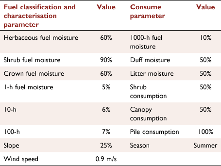
The Fuel and Fire Tools (FFT) ver. 2.0.2017 software application was used to characterise fuel loads, calculate fuel consumption, and calculate emissions of PM2.5 (https://www.fs.usda.gov/pnw/tools/fuel-and-fire-tools-fft). The FFT software contains both the Fuels Classification and Characterisation System (FCCS) and CONSUME models. FCCS characterises fuels for six vegetative strata: the canopy (and understorey), wood, shrubs, herbs, lichen/litter/moss (LLM), and ground fuels (i.e. duff and squirrel middens). CONSUME calculates fuel consumption and emissions of several air pollutants, including PM2.5. Fuel moisture and wind speed conditions needed by FFT were determined from the nearest representative Remote Automatic Weather System (RAWS) data and Fire Family Plus v5 (https://www.firelab.org/project/firefamilyplus). Table 1 presents the environmental inputs which were used in in the FFT model runs.
|
The FFT model was run for both the untreated fuels and treated fuels scenarios to calculate emissions. For both scenarios, the percentage of each fuel bed within the fire perimeter was determined using spatial analysis within the fire perimeter on the day of the case study and assigned within FFT.
Several vegetative data sets were considered to represent the fuel loads on the landscape when the fire burned through the landscape, including the Forest Inventory and Analysis (FIA) plot data (USDA Forest Service 2021a; https://www.fia.fs.fed.us/), Common Stand Examination (CSE) data maintained in the Field Sampled Vegetation (FSVeg) database (https://www.fs.fed.us/nrm/fsveg/), model-predicted vegetation data derived using the Fire and Fuels Extension of the Forest Vegetative Simulator (USDA Forest Service 2021b), and the Fuel Characterisation and Classification System (FCCS) data (McKenzie et al. 2007; Ottmar et al. 2007). All these vegetation data have their strengths and limitations. Based upon conversations with the forest fuels specialist, forest ecologist and a regional biometrician (S. Billings, D. McMahon, and T. Bryant, pers. comm.), it was agreed that the FCCS data was the best choice for the comparing the relative differences between smoke emissions from two scenarios. This decision was based upon the: (1) very-limited plot or stand exam data within the fire perimeter; (2) known inaccuracies associated with predicting fuel loads between plots (Pierce et al. 2009); and (3) the availability of recent FCCS data just prior to the case study fire.
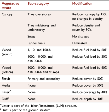
The FCCS default fuel loads were assumed to be representative of untreated fuels. Fuel loads were modified (Table 2) to represent the treated fuels scenario. The reduction in loading of each vegetative strata was based upon recommendations from the forest fuels specialist, forest ecologist and regional biometrician (S. Billings, D. McMahon, and T. Bryant, pers. comm.). The target reductions in fuel loads are generally representative of prescribed fire treatments in western forests within the Cascade region with a mixed severity fire regime.
|
Air quality concentrations
Due to the many known challenges with accurately modelling downwind concentrations of air pollutants from wildland fire (Liu et al. 2019; Peterson et al. 2022), a simple approach was selected to estimate the change in downwind concentrations based upon changes in emissions. The predicted 24-h average concentration of PM2.5 from the treated fuels scenario was determined by scaling the observed concentration of PM2.5 by the ratio between the model-predicted emissions from the untreated fuels scenario and the treated-fuels scenario. This assumes that the plume rise, meteorology, and atmospheric chemical transformations are the same between the two scenarios.
Results
Frequent air pathways
Fig. 2 illustrates the relative frequency of air pathways into five communities within the Rogue Basin during the study period. Because all the trajectory lines merge into the origin, this is always the grid cell with the highest frequency of occurrence. However, with increasing distance from each community, unique trajectory patterns are observed.

|
There are some similarities and differences amongst the air pathways into these communities. The air pathways into Shady Cove, Medford, and Ashland all show a predominant flow from the north-west, with Shady Cove and Medford also showing flow from the north-east, along the upper Rogue River. Grants Pass and Cave Junction both show frequent air flow from the north. Medford, Ashland, Grants Pass, and Cave Junction all show frequent air flow from the south-west, along the Highway 199 corridor. Air pathways that occur less than 3% of the time are not shown. Although smoke is transported from northern California into south-western Oregon, this pathway is not apparent because it occurs far less frequent than the shown pathways.
Case study source attribution
The date 2 August 2015 was selected for the case study because it was when Shady Cove experienced the highest 24-h average concentration of PM2.5 in the 5-year study period. On this day, the PM2.5 monitor in Shady Cove measured a 24-h average concentration of 295 µg/m3. Source apportionment modelling demonstrated that two wildfires contributed to the total PM2.5 concentration on this day: (1) the Stouts Creek Fire; and (2) the Cable Crossing Fire. Both fires were located within the frequent air pathways into Shady Cove (Fig. 3). The Stouts Creek Fire started on 30 July 2015 and was located 32 km northwest of Shady Cove. By 2 August 2015, the fire had grown to approximately 4330 ha. The Cable Crossing Fire started on 28 July 2015 and was located 77 km north-northwest of Shady Cove. By 2 August 2015, at the fire had grown to 677 ha. The modelled contribution from the Stouts Creek fire was 90% of the 24-h average concentration of PM2.5 in Shady Cove (0.9 × 295 = 265.5 µg/m3). The remaining 10% of the total observed PM2.5 concentration in Shady Cove was due to the Cable Crossing Fire (0.1 × 295 µg/m3 = 29.5 µg/m3).

|
Fuel beds and vegetative strata
Four fuel beds comprised 90% of the total area within the Stout’s Creek Fire perimeter on 2 August 2015; no other fuel bed represented more than 2%. To simplify the analysis, the relative percentages of the four fuel beds were recalculated assuming these comprised 100% of the area. Table 3 presents the FCCS description of fuel beds which were identified within the fire perimeter and the percentage of each fuel bed within the perimeter.

|
Emissions
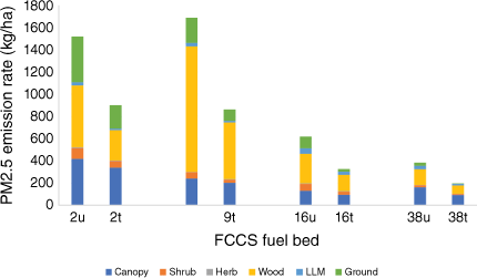
Fig. 4 illustrates the emission rate on a per hectare basis for each fuel bed and vegetative strata, for both the untreated (u) and treated (t) fuels scenario. Before and after treatment, fuel beds 2 and 9 had substantially larger unit emission rates than fuel beds 16 and 38. As such, these fuel beds had the greatest potential to reduce smoke from subsequent wildfires after a treatment, on a per hectare basis. However, fuel bed 9 only accounts for 7% of the total area and fuel bed 16 accounts for 61% of the total area. Thus, both the emission rate per area and percentage of total area needs to be considered when identifying the greatest potential for emission reductions from a fuels treatment.
|
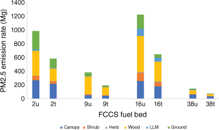
Fig. 5 combines these two considerations (emission rate per area and percent total area of each fuel bed) by illustrating the total PM2.5 emissions before and after the fuel treatment. The fuel treatment resulted in a change in PM2.5 emissions from a total of 2744 Mg before treatment to 1506 Mg after treatment, which is a 45% reduction in emissions. FCCS fuel bed 16 and 2 emitted the most PM2.5 both before and after the fuel treatments. On average, the canopy, wood, and ground fuels combined contributed 88% of the total PM2.5 emissions, whereas the shrub, herb, and LLM strata only contributed 12% of the total PM2.5 emissions. The largest reduction in PM2.5 emissions occurred in FCCS fuel bed 16 and 2, primarily due to the change in wood and ground strata. These two strata alone accounted for 74% of the total reduction in PM2.5 emissions (i.e. wood accounted for 48% and the ground fuels accounted for 26%).
|
Impacts of fuel treatments on air quality
The total observed 24-h average concentration of PM2.5 in Shady Cove on 2 August 2015 was 295 µg/m3, which is associated with the emissions from the burning of untreated fuels. Assuming that the fuels from the Stouts Creek Fire were treated just prior to the fire, the calculated 24-h average concentration of PM2.5 would have been 162 µg/m3, if this fire was the sole contributing source, as shown below. This would have resulted in a 45% reduction in the observed concentration of PM2.5 on this day.


However, this value must be adjusted to account for the contribution of the Cable Crossing fire, which contributed 29.5 µg/m3 (i.e. 10% of the total observed PM2.5 concentration). Adding the contribution from the Cable Crossing Fire, the revised estimated concentration of PM2.5 in Shady Cove would have been 175 µg/m3 as shown below:

This is equivalent to a 41% reduction in smoke.
Discussion
Frequent air pathways into communities provide critical information needed to reduce the duration and concentration of smoke into communities frequently impacted by smoke from wildfire smoke; i.e. they show the relationship between the source of the smoke and the community that receives the smoke. The pathways can help fire managers reduce the duration of wildfire smoke in a community through priority allocation of firefighting resources during wildfire season. When fires begin within a frequent air pathway for a community, fire leadership can consider this information in several ways. If the fire is likely to be of long duration and lying within the footprint of a frequent air pathway into a community, it is likely that the community will experience long periods (e.g. weeks to more than a month) of wildfire smoke. This information could be considered when allocating resources to both initial and extended attack. Extra resources can limit the extent and duration of a wildfire, and the associated smoke, which may be critically important in communities where hospitals and other health care resources are at or near capacity, as occurred during 2020–2021 COVID pandemic.
The frequent air pathways can help land managers reduce the concentration of PM2.5 and other pollutants emitted by a wildfire in a community by prioritising where fuel treatments are conducted and how they are conducted. The case study demonstrated the potential benefit to community air quality when a fuel treatment, within the footprint of the frequent air pathway, interacted with a wildfire. The air quality concentration in the downwind community could have been reduced up to 45%. The advantage of displaying the frequent air pathways in a GIS format allows land managers to overlay this information with other GIS layers associated with fire probability, fire regime, vegetation condition, class, topography, and other information needed to decide where to place fuel treatments.
The air pathway maps may also be helpful to Air Resource Advisors, air quality agencies, and public health officials to help inform the public of the likely duration of smoke impacts into a downwind community should a wildfire occur within a frequent air pathway. If the wildfire is likely to be of long duration, in the absence of transient weather systems, the smoke from the wildfire is likely to cause long periods of smoke in downwind communities. Rather than just providing a 24–48 h forecast of smoke, these professionals now have a tool to help advise the public of a long-duration smoke event. With this information, the public can make a more informed decision about whether to leave the area or stay and municipalities can make informed decisions about opening clean air shelters.
The analyses techniques in identifying frequent air pathways have other applications outside of this study. For example, they can be used to identify potential areas of influence for sources of air pollution as causing high concentrations of pollutant deposition, regional haze, or toxic air pollution. One need only modify the selected period to model, the meteorological model that generates the data, or length of back-trajectories suitable to the application of interest. Many such examples are available on the HYSPLIT website (www.arl.noaa.gov/hysplit/).
The case study also revealed differences in the emissions potential amongst different fuel beds and vegetative strata that could be used to design fuel treatments. These insights could be used to reduce smoke emissions and downwind impacts from subsequent wildfires during the planning stages of land management activities, should a desired condition be identified upfront.
Consider a situation in which a desired condition was identified in the planning process to have 50% less smoke during wildfires in downwind communities as compared to current conditions. For the case study presented, this would result in a slight increase in the reduction of canopy fuels, wood, and/or ground fuels over what was prescribed. Such an objective would likely substantially reduce the risk to human health to people who live and work in communities frequently impacted by wildfire smoke. Of course, there are competing objectives which may need to leave these strata in place. For example, to maintain habitat for wildlife, a silvicultural prescription may require that 80% of the 1000-h fuels remain in place. However, other fuel strata may be reduced to compensate for the smoke emissions from the 1000-h fuels, and still meet the objective of reducing wildfire smoke in downwind communities.
Limitations
There are several limitations of the frequent air pathways that result from the limitations of the underlying meteorological forecast data, model input parameters, and display of information. Certainly, smoke may be transported from areas outside of the frequent pathways with the passage of transient weather systems. Also, because the back-trajectories are only for 36-h, they do not capture smoke from fires far away from the impacted communities. The 36-h time frame was deliberately selected to focus on local solutions to frequent smoke impacts. Additionally, should seasonal weather patterns differ from the patterns captured during the study period, the frequent pathways may not be representative of those conditions. Finally, air flow patterns may not be captured by the resolution of the meteorological forecast data such as within narrow valleys. Thus, users are cautioned to interpret the air pathways accordingly.
Two aspects of the modelling approach helped to reduce error in the results. By modelling over 1500 back-trajectories for a single community, any error in single trajectory has minimal influence on the overall result. Additionally, using a radius of influence when applying the line density function, also acts to smooth the overall results.
In addition to the limitation in the frequent air pathways, the amount of wildfire smoke reduced in each community is also dependent on four factors: (1) the number of fires contributing smoke; (2) the total area burned on each of these fires on a given day; (3) the number of these fires that received fuel treatments; and (4) the time between the fuel treatment and the wildfire event. The predicted reduction in the ambient 24-h concentration of PM2.5 in Shady Cove could have been more if both fires that contributed smoke into Shady Cove had received fuel treatments, or if the fuel treatments allowed firefighters to contain the fires thus avoiding further fuel consumption. However, because treatment extent is constrained for several reasons like slope steepness, habitat concerns, worker safety, or other practical matters, less than 50% of federal lands in the Rogue Basin are accessible via existing roads (Metlen et al. 2021), consistent with accessibility in the Sierra Nevada Mountains (North et al. 2015).
Conclusions
This study examined the question of ‘what more could be done to reduce wildfire smoke in frequently impacted communities’? To help answer this question, the authors approached this study from a community perspective by evaluating where smoke comes from when it enters a community. By conducting thousands of back-trajectory modelling runs and processing this information in ArcGIS, the authors were able to create maps of frequent air pathways into five communities which are often impacted by wildfire smoke. The maps revealed distinct patterns of air flow for each community.
A case study was then presented to illustrate how much air quality could be improved in a community with the use of targeted fuel treatments by focusing on where the fuel treatments occur and the specific fuel beds and vegetative layers which emit the most smoke during a wildfire.
Two of the fuel beds (FCCS fuel beds 2 and 9) emitted three times as much PM2.5 as the other two fuels beds (FCCS fuel beds 16 and 38) on a per hectare basis, but because the extent of each fuel bed was not equal across the fire, fuel beds 16 and 2 contributed the most PM2.5 emissions. Thus, one must consider both the unit emission rate of each fuel bed and the relative percent of the total area of each fuel to identify the best fuel beds to reduce emissions.
The fuel treatment resulted in a change in PM2.5 emissions from a total of 2744 Mg before treatment to 1506 Mg after treatment, which is a 45% reduction in emissions. On average, the canopy, wood, and ground fuels combined contributed 88% of the total PM2.5 emissions, whereas the shrub, herb, and LLM strata only contributed 12% of the total PM2.5 emissions. The largest reduction in PM2.5 emissions occurred primarily due to the change in the wood and ground strata. These alone accounted for 74% of the total reduction in PM2.5 emissions (i.e. wood accounted for 48% and the ground fuels accounted for 26%).
Assuming a linearly proportional decrease in downwind concentrations to the change in emission rates, air quality impacts could have been reduced by as much as 45% on the worst-case day if only the fire with treated fuels was the sole contributor. However, the authors assumed that a more distant fire that contributed 10% of the impacts did not receive fuel treatments. Thus, in this alternative scenario, the reduction in PM2.5 concentration on the worst-case day was only 41%.
Several suggestions were presented for fire and land managers on how to use the frequent air pathways maps to reduce the duration and concentration of smoke in frequently impacted communities before and during wildfire occurrence. During wildfire season, fire managers could consider using the frequent air pathway maps to quickly understand if a fire is likely to cause long periods of smoke in a community. Such information may be helpful in informing discussions prioritising the allocation of limited fire suppression resources.
The case study analyses revealed substantial differences between potential smoke emissions from different fuel beds and vegetative strata. Knowledge of these differences could inform fuel treatments should an air quality objective be added to address smoke from subsequent wildfires. The authors demonstrated how targeted fuel treatments could reduce the concentration of PM2.5 by 41% in a downwind community. As such, the authors conclude that there is more that could be done to reduce smoke from wildfires beyond current practices.
Data availability
The data that support this study will be shared upon reasonable request to the corresponding author.
Conflicts of interest
The authors declare no conflicts of interest.
Declaration of funding
Funding for this study was provided solely by the USDA Forest Service.
Acknowledgements
The authors thank Janice L. Peterson, Chris Mushrush, Spencer Ware, Joel Thomas, and Dacey Mercer who provided helpful comments on the initial outline of the manuscript. Janice was also helpful in gathering air quality monitoring data. Both Chris and Spencer were helpful in gathering an analysing the fire and vegetative data. Joel and Darcey created the Python script to convert the HYSPLIT output into an ArcGIS suitable format for creating the line density raster images. Dacey also help create the R-script needed to run the analyses in communities beyond the Rogue Basin. We also thank Darcy McDaniel, Sara Billings, Rob Budge, and Kerry Metlen for their review of the manuscript, and Desraye Assali for helping to create the final figures.
References
D’Evelyn SM, Jung J, Alvarado E, Baumgartner J, Caligiuri P, Hagmann RK, Henderson SB, Hessburg PF, Hopkins S, Kasner EJ, Krawchuk MA, Krenz JE, Lydersen JM, Marlier ME, Masuda YJ, Metlen K, Mittelstaedt G, Prichard SJ, Schollaert CL, Smith EB, Stevens JT, Tessum CW, Reeb-Whitaker C, Wilkins JL, Wolff NH, Wood LM, Haugo RD, Spector JT (2022) Wildfire smoke exposure, human health, and environmental justice need to be integrated into forest restoration and management. Current Environmental Health Reports 9, 366–385.| Wildfire smoke exposure, human health, and environmental justice need to be integrated into forest restoration and management.Crossref | GoogleScholarGoogle Scholar |
Draxler RR (1999) ‘HYSPLIT4 user’s guide.’ NOAA Tech. Memo. ERL ARL-230. (NOAA Air Resources Laboratory: Silver Spring, MD)
Draxler RR, Hess GD (1997) ‘Description of the HYSPLIT_4 modeling system.’ NOAA Tech. Memo. ERL ARL-224. 24 p. (NOAA Air Resources Laboratory: Silver Spring, MD)
Draxler RR, Hess GD (1998) An overview of the HYSPLIT_4 modeling system of trajectories, dispersion, and deposition. Australian Meteorological Magazine 47, 295–308.
Halofsky JE, Peterson DL, Harvey BJ (2020) Changing wildfire, changing forests: the effects of climate change on fire regimes and vegetation in the Pacific Northwest, USA. Fire Ecology 16, 4
| Changing wildfire, changing forests: the effects of climate change on fire regimes and vegetation in the Pacific Northwest, USA.Crossref | GoogleScholarGoogle Scholar |
Laumbach RJ (2019) Clearing the Air on Personal Interventions to Reduce Exposure to Wildfire Smoke. Annals of the American Thoracic Society 16, 815–818.
| Clearing the Air on Personal Interventions to Reduce Exposure to Wildfire Smoke.Crossref | GoogleScholarGoogle Scholar |
Liu ZF, Murphy J, Maghirang R, Devlin D (2016a) Health and Environmental Impacts of Smoke from Vegetation Fires: A Review. Journal of Environmental Protection 7, 1860–1885.
| Health and Environmental Impacts of Smoke from Vegetation Fires: A Review.Crossref | GoogleScholarGoogle Scholar |
Liu JC, Mickley LJ, Sulprizio MP, Dominici F, Yue X, Ebisu K, Brooke Anderson B, Khan RFA, Bravo MA, Bell ML (2016b) Particulate air pollution from wildfires in the Western US under climate change. Climatic change 138, 655–666.
| Particulate air pollution from wildfires in the Western US under climate change.Crossref | GoogleScholarGoogle Scholar |
Liu Y, Kochanski A, Baker KR, Mell W, Linn R, Paugam R, Mandel J, Fournier A, Jenkins MA, Goodrick S, Achtemeier G, Zhao F, Ottmar R, French NHF, Larkin N, Brown T, Hudak A, Dickinson M, Potter B, Clements C, Urbanski S, Prichard S, Watts A, McNamara D (2019) Fire behaviour and smoke modelling: model improvement and measurement needs for next-generation smoke research and forecasting systems. International Journal of Wildland Fire 28, 570–588.
| Fire behaviour and smoke modelling: model improvement and measurement needs for next-generation smoke research and forecasting systems.Crossref | GoogleScholarGoogle Scholar |
McClure CD, Jaffee DA (2018) US particulate matter air quality improves except in wildfire-prone areas. Proceedings of the National Academy of Sciences 115, 7901–7906.
| US particulate matter air quality improves except in wildfire-prone areas.Crossref | GoogleScholarGoogle Scholar |
McKenzie D, Raymond CL, Kellogg L-KB, Norheim RA, Andreu AG, Bayard AC, Kopper KE, Elman E (2007) Mapping fuels at multiple scales: landscape application of the Fuel Characteristic Classification System. Canadian Journal of Forest Research 37, 2421–2437.
| Mapping fuels at multiple scales: landscape application of the Fuel Characteristic Classification System.Crossref | GoogleScholarGoogle Scholar |
Metlen KL, Skinner CN, Olson DR, Nichols C, Borgias D (2018) Regional and local controls on historical fire regimes of dry forests and woodlands in the Rogue River Basin, Oregon, USA. Forest Ecology and Management 430, 43–58.
| Regional and local controls on historical fire regimes of dry forests and woodlands in the Rogue River Basin, Oregon, USA.Crossref | GoogleScholarGoogle Scholar |
Metlen KL, Fairbanks T, Bennett M, Volpe J, Kuhn B, Thompson MP, Thrailkill J, Schindel M, Helmbrecht D, Scott J, Borgias D (2021) Integrating forest restoration, adaptation, and proactive fire management: Rogue River Basin Case Study. Canadian Journal of Forest Research 51, 1292–1306.
| Integrating forest restoration, adaptation, and proactive fire management: Rogue River Basin Case Study.Crossref | GoogleScholarGoogle Scholar |
National Wildfire Coordination Group (2020) NWCG Smoke Management Guide for Prescribed Fire. PMS 420-3, NFES 001279. November. Available at https://www.nwcg.gov/sites/default/files/publications/pms420-3.pdf
North M, Brough A, Long J, Collins B, Bowden P, Yasuda D, Miller J, Sugihara N (2015) Constraints on mechanized treatment significantly limit mechanical fuels reduction extent in the Sierra Nevada. Journal of Forestry 113, 40–48.
| Constraints on mechanized treatment significantly limit mechanical fuels reduction extent in the Sierra Nevada.Crossref | GoogleScholarGoogle Scholar |
Oregon Administrative Rules (OAR) (2019) Chapter 629 Division 48 Smoke Management. 1 March. Available at https://secure.sos.state.or.us/oard/displayDivisionRules.action?selectedDivision=2849
Oregon Forests Resources Institute (2018) Impacts of Oregon’s 2017 Wildfire Season – Time for a Crucial Conversation. (Oregon Forests Resources Institute: Portland, OR) Available at https://oregonforests.org/sites/default/files/2018-01/OFRI%202017%20Wildfire%20Report%20-%20FINAL%2001-02-18.pdf
Ottmar RD, Sandberg DV, Riccardi CL, Prichard SJ (2007) An overview of the Fuel Characteristic Classification System — Quantifying, classifying, and creating fuelbeds for resource planning. Canadian Journal of Forest Research 37, 2383–2393.
| An overview of the Fuel Characteristic Classification System — Quantifying, classifying, and creating fuelbeds for resource planning.Crossref | GoogleScholarGoogle Scholar |
Peterson DL, McCaffrey SM, Patel-Weynand T (Eds) (2022) ‘Wildfire Smoke in the United States, A Scientific Assessment.’ (Springer Publishing: New York)
Pierce Jr KB, Ohmann JL, Wimberly MC, Gregory MJ, Fried JS (2009) Mapping wildland fuels and forest structure for land management: a comparison of nearest-neighbor imputation and other methods. Canadian Journal of Forest Research 39, 1901–1916.
| Mapping wildland fuels and forest structure for land management: a comparison of nearest-neighbor imputation and other methods.Crossref | GoogleScholarGoogle Scholar |
Rolph G, Stein A, Stunder B (2017) Real-time Environmental Applications and Display system: READY. Environmental Modelling & Software 95, 210–228.
| Real-time Environmental Applications and Display system: READY.Crossref | GoogleScholarGoogle Scholar |
Sensenig T, Bailey JD, Tappeiner JC (2013) Stand development, fire and growth of old-growth and young forests in southwestern Oregon, USA. Forest Ecology and Management 291, 96–109.
| Stand development, fire and growth of old-growth and young forests in southwestern Oregon, USA.Crossref | GoogleScholarGoogle Scholar |
Short KC (2021) ‘Spatial wildfire occurrence data for the United States, 1992-2018 [FPA_FOD_20210617]’, 5th edn. (Forest Service Research Data Archive: Fort Collins, CO)
| Crossref |
Stein AF, Draxler RR, Rolph GD, Stunder BJB, Cohen MD, Ngan F (2015) NOAA’s HYSPLIT Atmospheric Transport and Dispersion Modeling System. Bulletin of the American Meteorological Society 96, 2059–2077.
| NOAA’s HYSPLIT Atmospheric Transport and Dispersion Modeling System.Crossref | GoogleScholarGoogle Scholar |
USDA Forest Service (2021a) ‘Forest Inventory and Analysis Database: Database Description and User Guide for Phase 2 (version 9.0.1).’ (US Department of Agriculture, Forest Service: Washington DC)
USDA Forest Service (2021b) ‘The Fire and Fuels Extension to the Forest Vegetation Simulator: Updated Model Documentation.’ (US Department of Agriculture, Forest Service, Forest Management Service Center: Fort Collins, CO)
USDA Forest Service (2022) Confronting the Wildfire Crisis: A Strategy for Protecting Communities and Improving Resilience in American’s Forests. FS-8711a. Available at https://www.fs.usda.gov/sites/default/files/Confronting-Wildfire-Crisis.pdf
Wang YQ, Zhang XY, Draxler RR (2009) TrajStat: GIS-based software that uses various trajectory statistical analysis methods to identify potential sources from long-term air pollution measurement data. Environmental Modelling & Software 24, 938–939.
| TrajStat: GIS-based software that uses various trajectory statistical analysis methods to identify potential sources from long-term air pollution measurement data.Crossref | GoogleScholarGoogle Scholar |
Weber KT, Yadav R (2020) Spatiotemporal Trends in Wildfires across the Western United States (1950–2019). Remote Sensing 12, 2959
| Spatiotemporal Trends in Wildfires across the Western United States (1950–2019).Crossref | GoogleScholarGoogle Scholar |
Wilmot TY, Hallar AG, Lin JC, Mallia DV (2021) Expanding number of Western US urban centers face declining summertime air quality due to enhanced wildland fire activity. Environmental Research. Letters. 16, 054036
| Expanding number of Western US urban centers face declining summertime air quality due to enhanced wildland fire activity.Crossref | GoogleScholarGoogle Scholar |
Wimberly MC, Liu Z (2014) Interactions of climate, fire, and management in future forests of the Pacific Northwest. Forest Ecology and Management 327, 270–279.
| Interactions of climate, fire, and management in future forests of the Pacific Northwest.Crossref | GoogleScholarGoogle Scholar |