

Future expansion, seasonal lengthening and intensification of fire activity under climate change in southeastern France
François Pimont A * , Julien Ruffault A , Thomas Opitz B , Hélène Fargeon A , Renaud Barbero C , Jorge Castel-Clavera A , Nicolas Martin-StPaul A , Eric Rigolot A and Jean-Luc Dupuy A
A URFM, INRAE, Domaine Saint Paul, Site Agroparc, 84000 Avignon, France.
B BioSP, INRAE, Avignon, France.
C RECOVER, INRAE, Aix-en-Provence, France.
International Journal of Wildland Fire 32(1) 4-14 https://doi.org/10.1071/WF22103
Submitted: 22 June 2022 Accepted: 11 November 2022 Published: 5 December 2022
© 2023 The Author(s) (or their employer(s)). Published by CSIRO Publishing on behalf of IAWF. This is an open access article distributed under the Creative Commons Attribution-NonCommercial-NoDerivatives 4.0 International License (CC BY-NC-ND)
Abstract
Background: An increase in fire weather is expected in a warming climate, but its translation to fire activity (fire numbers and sizes) remains largely unknown. Additionally, disentangling the extent to which geographic and seasonal extensions as well as intensification contribute to future fire activity remain largely unknown.
Aims: We aimed to assess the impact of future climate change on fire activity in southeastern France and estimate changes in spatial and seasonal distributions.
Methods: We projected future fire activities using a Bayesian modelling framework combined with ensemble climate simulations. Changes in numbers of escaped fires (>1 ha), large fires (>100 ha) and burned area were studied for different emission scenarios or degrees of global warming.
Key results: Fire activity could increase by up to +180% for +4°C of global warming, with large expansions of fire-prone regions and long seasonal lengthenings. Overall, changes will be dominated by intensification within the historical fire niche, representing two-thirds of additional future fire activity, half of this occurring during the high fire season.
Conclusions: This study confirms that major changes in fire niches would be expected in Euro-Mediterranean regions.
Implications: Long-term strategic policies for adapting prevention and suppression resources and ecosystems are needed to account for such changes.
Keywords: climate change, expansion, extension, fire niche, fire risk severity, fire season length, Firelihood, Mediterranean, projections, risk assessement, seasonal, spatial.
Introduction
The impacts of climate change on wildfires have already been observed over the last decades with an increase in burned areas across parts of the globe (Jones et al. 2022). This trend is expected to further increase over the current century (Amatulli et al. 2013; Williams and Abatzoglou 2016; Dupuy et al. 2020), as will the potential for large fires (Barbero et al. 2015; Ruffault et al. 2020), even if certain other bioclimatic and human factors may mediate or override the effects of fire weather (Jones et al. 2022). Quantifying future fire activity (i.e. number and sizes of fires) at regional scales is critical to set out strategic policies, to determine long-term requirements for human and equipment resources and to anticipate future ecological impacts of fire (Taylor 2020). However, quantifying those changes remains challenging at a regional scale because of the complex interactions between climate, meteorology, vegetation, humans and fires (Jones et al. 2022).
With the future predicted increase in fire weather, the fire niche (Balch et al. 2017) – the location and period of year with significant fire activity – is expected to expand, with a spatial expansion of fire-prone areas and a lengthening of the current fire season (i.e. more days with fire-prone conditions) (Flannigan et al. 2013). Moreover, an intensification (i.e. increased fire activity) is expected within the historical niche (Dong et al. 2022; Senande-Rivera et al. 2022). Thus, future changes in fire activity could reflect both an intensification inside the historically fire-prone region and outside these areas by expansion. Similarly, future changes could arise from an intensification during the historical fire season and outside this period. To date, disentangling the extent to which intensification inside the niche, seasonal lengthening and spatial expansion contribute to future fire activities has rarely been addressed.
Southeastern France shows a gradient between lowland areas exhibiting already strong fire activity and more mountainous areas where activity is more limited. Such a limitation is not due to lower fuel availability, but to human ignitions and climate conditions (Fréjaville and Curt 2015; Dupire et al. 2019). However, drought conditions are expected to worsen throughout the Euro-Mediterranean basin (Drobinski et al. 2020; Cos et al. 2022) through the mediterranean amplification (Brogli et al. 2019). This may affect fire activity, as the relationships between fire weather and burnt areas are exceptionally strong in Euro-Mediterranean areas (Jones et al. 2022). As a consequence, mountainous regions may turn from fire-free to fire-prone locations (Resco de Dios et al. 2021). Southeastern France has already seen an increase in heat waves mostly attributed to anthropogenic climate change, resulting in drastic increase in the frequency and magnitude of extreme fire weather conditions (Barbero et al. 2020). This region is also expected to be the most impacted by changes in fire weather in France, with a high degree of confidence (Fargeon et al. 2020).
However, translating fire weather increases into realised fire activity is, for several reasons, not straightforward. First, the relationship between fire weather and fire activity is not linear, because the response of numbers of fires and their size are not proportional to fire weather indices, exhibiting both convex increase and saturation depending on the range of fire weather values (e.g. Pimont et al. 2021). As a result, an increase in fire weather is not expected to turn into a proportional increase in burned area or numbers of fires, which limits the conclusions drawn from fire weather index projections. Second, fire suppression, land use or land management strongly shapes fire activities (Andela et al. 2017; Jones et al. 2022), especially in this region (Ruffault and Mouillot 2015; Evin et al. 2018), causing large spatial and temporal variations in atmosphere–fire relationships (Fréjaville and Curt 2015; Ruffault and Mouillot 2017; Turco et al. 2018; Pimont et al. 2021; Castel-Clavera et al. 2022). Finally, a large part of fire activity in this region occurs during day-scale meteorological events (Ruffault et al. 2017), challenging projections based on monthly or seasonal fire weather (Williams and Abatzoglou 2016).
Here, we projected fire activity in southeastern France with the Bayesian probabilistic Firelihood model (Pimont et al. 2021), which is described in the Methods section. In brief, Firelihood uses the widespread Fire Weather Index (FWI, Van Wagner 1987) to rate daily fire danger and accounts for fire stochasticity and the spatial variations in fire weather relationships observed at regional scales. We studied changes in the fire niche by analysing the spatial expansion, seasonal lengthening and intensification of future fire activities under two emission scenarios (Representative Concentration Pathways, RCP 4.5 and 8.5) of the EURO-CORDEX initiative (Kotlarski et al. 2014) for mid and long terms, as well as global warming levels from +1.5 to 4°C.
Methods
The workflow of the study is presented in Fig. 1. The first step consisted in projecting the FWI obtained from 13 climate models for two representative emission concentration pathways (RCP 4.5 and 8.5). In the second step, Firelihood was used to simulate fire activity metrics for the 26 projected FWI simulations. Then, projected fire activity metrics were analysed to estimate the future spatial and seasonal distributions of fire activity.

|
Projections of the Fire Weather Index
FWI values were estimated from weather data simulated by 13 climate models of the EURO-CORDEX initiative for both RCPs (Kotlarski et al. 2014), leading to 26 FWI simulations (Supplementary Table S1). Simulations resulted from dynamical downscaling through coupling of Global Climate Models (GCMs) with Regional Climate Models (RCMs). FWI was computed using the ‘cffdrs’ R package (Wang et al. 2017). Following Bedia et al. (2014), FWI calculation was based on daily cumulated precipitation, mean wind speed and temperature, and minimum relative humidity calculated using specific humidity and maximum temperature of the day (Fargeon et al. 2020). We considered two scenarios: RCP 4.5 and 8.5, developed for IPCC (Intergovernmental Panel on Climate Change) Assessment Reports. Climate simulations were downscaled and bias-corrected at 8-km resolution with a multivariate bias-correction method based on quantile mapping (MBC_n from the R package MBC, Cannon 2018) and using the 1971–2005 SAFRAN reanalysis data set (Vidal et al. 2010) as reference.
Projections of fire activity metrics
Firelihood (Pimont et al. 2021) is a probabilistic Bayesian framework designed for stochastic modelling of fire activity (number and size) in southeastern France during the warm season (June–October, days of year 149–308). The occurrence of escaped fires (i.e. number of fires larger than 1 ha) is modelled through a space–time Poisson process simulating the number of fires occurring in each 8-km pixel and day of year. For each fire, its burnt area (fire size in ha) is assigned by sampling from the estimated distribution of fire sizes in each pixel and day. This distribution is modelled with a combination of exceedance thresholds, as well as piecewise Pareto and Generalised Pareto distributions based on fire size intervals of 1–10, 10–100, 100–1000 and larger than 1000 ha. Explanatory variables are the FWI, which summarises the influence of fire weather on daily fire danger, and the forest area as a landscape factor representing exposure to fuel availability. Firelihood also includes sophisticated spatio-temporal effects to account for patterns that remain unexplained by explanatory variables. They include a random spatial effect with Matérn covariance, and seasonal and yearly random effects to appropriately capture residual spatiotemporal variability of the occurrence patterns (Pimont et al. 2021). More recent work revealed that the size distribution also exhibited spatial dependencies (Koh et al. 2023). In order to improve the spatial accuracy of fire projection, the original version of the model (Pimont et al. 2021) was slightly improved with the introduction of a spatial effect operating at NUTS3 levels (Nomenclature of Units for Territorial Statistics, which corresponds to aggregations of municipalities or provinces) in exceedance threshold and piecewise Pareto models (Supplementary Table S3), allowing improved spatial distributions of fire sizes. The model was estimated over 1995–2014 and evaluated over 2014–2018 (Pimont et al. 2021). It implements a fixed effect ‘post 2003’ in the occurrence model component, which can be viewed as a simplified annual effect to account for abrupt changes in the atmosphere–fire relationship near 2003 (Pimont et al. 2021). This estimated ‘post-2003’ effect was applied to our 2001–2100 projections, so that these projections could be considered as representative of the atmosphere–fire relationship of 2004–2018. More recent studies have shown that atmosphere–fire relationships have been stable over these recent periods (Castel-Clavera et al. 2022; Koh et al. 2023), which strengthens the modelling assumption of a fixed ‘post 2003’ annual effect, initially done in Pimont et al. (2021). This modelling strategy hence allows us to project a meaningful extrapolation of the current situation.
For each of the 26 FWI simulations, Firelihood was used repeatedly by sampling from the posterior distribution of the Bayesian model to provide 300 replications of fire activities, which represented both the distributional uncertainty associated with stochastic processes at play (Poisson, Bernoulli, Pareto and Generalised Pareto), and the statistical uncertainty from the estimation of model parameters. These fire activities were used to compute five different fire metrics in each pixel and day: the expected numbers of fires larger than 1, 10, 100 and 1000 ha (N1ha, N10ha, N100ha and N1000ha respectively) and burnt areas (BAs), which were aggregated over time and space for each climate model. Multi-model means were therefore computed, as well as the model standard deviation, which represents the uncertainty associated with climate models (Fargeon et al. 2020).
Emission scenarios, time horizons and global warming levels
For RCP 4.5 and 8.5, we considered mid- (2041–2060) and long-term (2080–2099) horizons by averaging projected fire activities for these periods. For comparison, we also defined a 20-year reference corresponding to the recent ‘historical’ period, labelled ‘2001–2020’, constructed from mean Firelihood projections for RCP 4.5 and 8.5 during these years. This historical estimation should be considered as a theoretical reference, which differs from observations for two main reasons. First, simulations were based on the atmosphere–fire relationships of the stable 2004–2020 period, but underestimate observations for the 2001–2003 period, which includes the catastrophic 2003 year (Supplementary Table S4). Secondly, climate simulations lead to lower fire weather than observed, which is explained by the fact that only half of the observed increase in FWI at this period (approximately +20%) was reproduced by climate models (Barbero et al. 2020). As a result, fire activities simulated by Firelihood were lower when derived from climate models than from SAFRAN reanalysis.
We considered four global warming scenarios (+1.5, +2, +3 and +4°C) by averaging fire activities over 20-year periods centred on the dates at which corresponding global warming levels were reached for each GCM under the RCP 8.5. For the +4°C scenario, only 8 of the 13 climate models were used, as this level was either unknown or not reached at simulation end dates (Supplementary Table S2).
Spatial expansion and seasonal lengthening of the future fire niche
The spatial and seasonal extents of the fire niche for the different time horizons and global warming levels were determined from objective levels obtained from spatial and seasonal clustering applied to three important fire metrics (N1, N100ha and BA). Spatial and seasonal changes in levels were then used to estimate the expansion and the lengthening of future fire niches.
Fire metrics were first aggregated per pixel and day of year to estimate spatial and seasonal fire activities, respectively. Then, they were classified according to five levels corresponding to low, moderate, high, very high and extreme fire activities using ‘k-means’ clustering. We applied two different clusters for spatial and seasonal metrics and estimated these clusters from fire metrics of the three time horizons under RCP 8.5 (historical reference, mid and long terms). A ‘Butterworth’ filter was applied to seasonal metrics with 7-day smoothing to increase the robustness of seasonal patterns (Mann 2004, 2008).
We defined the fire-prone and highly fire-prone regions as the locations with spatial levels of fire activity ‘at least moderate’ and ‘at least high’ during the reference period, respectively. We then considered the spatial expansion of the fire niche, based on future pixel shifts towards higher levels.
Similarly, we defined the fire season and the high fire season as the periods with seasonal levels of fire activity ‘at least moderate’ and ‘at least high’ during the reference period, respectively. We then considered the seasonal lengthening of the fire niche, based on the number of days shifting towards higher levels.
Relative contributions of intensification, expansion and lengthening to future increases in fire activity
We studied how additional fire activity induced by climate change was distributed with respect to the historical spatiotemporal fire niche, in order to disentangle whether increases in fire activity mostly occurred owing to intensification inside the fire niche or from extension of the fire niche. For spatial patterns, we aggregated the anomalies (computed with respect to the 2001–2020 reference) of fire metrics (N1ha, N100ha, BA) in pixels located respectively inside and outside the historical fire-prone and highly fire-prone regions. Similarly, anomalies in those fire metrics were aggregated within and beyond the historical fire and high fire seasons.
Results
Projected trends in fire activity for the whole region
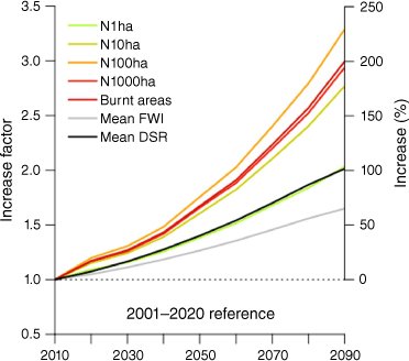
Projected trends for N1ha, N100ha and BA are represented in Fig. 2. Overall, projected global warming induced large increases of the three metrics compared with the reference period (2001–2020). Similar increases were observed until 2050 under both RCPs, RCP 8.5 being slightly higher than RCP 4.5. The trends, however, contrasted greatly in the second half of the century, with an acceleration under RCP 8.5, but a stabilisation under RCP 4.5. According to these projections, ~15 000 ha burned, 20 large fires and 350 escaped fires per year would be expected for the end of the century under RCP 8.5. The mean emergence dates of +2 and +4°C were respectively ~2040 and 2080 (under RCP 8.5).

|
Climate model uncertainties (vertical lines) increased with time and magnitude of fire activities. They were also larger for fixed horizons than for global warming levels, because the forced convergence of global predictions reduced the climate model uncertainty, but at the cost of uncertainty in timing (horizontal lines). Finally, simulated fire activity during the reference period (2001–2020) was slightly below the observations (2004–2019, in black), as explained in the Methods section.
Fig. 3 shows the relative increase in different fire metrics (N1ha, N10ha, N100ha, N1000ha and BA) under RCP 8.5 (RCP 4.5 in Supplementary Fig. S1). Near the end of the century, the increase factor ranged between 2.1 and 3.4 for N1ha and N100ha, respectively. N1000ha and BA increased by 3–3.1, which was slightly less than N100ha, the fire activity metric exhibiting the largest increases. In agreement with Fig. 2, these factors were slightly higher than those reached for +2 and +4°C of global warming (Supplementary Table S4). The increase factor would reach a plateau at ~1.5 in 2050 under RCP 4.5 for all metrics except N1ha (1.34). For reference, these trends were compared with mean FWI and Daily Severity Rating (DSR, often used to estimate the difficulty to control fires, Flannigan et al. 2013). The increase was faster for all fire activity metrics than for FWI and DSR, except for 1 ha fires (see also Supplementary Table S4).
|
Spatial expansion of the fire-prone and highly fire-prone regions
Reference and future (+2 and +4°C) fire activities were mapped by spatial levels of fire activity in Fig. 4 (other horizons and global warming levels are available in Supplementary Fig. S1). During the reference period, areas with moderate or higher fire activities (i.e. fire-prone region) covered 28% of southeastern France. We note here that the fire metrics for the ‘low’ spatial level of fire activity were of the order of 3–4.6 times lower than for the moderate levels, highlighting the huge contrast between the fire-prone region and the rest of the territory. Areas with levels at least ‘high’ covered 8% of the territory (highly fire-prone region). Spatial coverages of other levels are shown in Fig. 5a. Fire activity metrics typically increased by a factor of 2 when switching levels.

|

|
With +2 and +4°C, the spatial extent of the fire-prone and highly fire-prone regions strongly increased, these regions covering approximately two-thirds and one-third of the territory with +4°C, with a marked expansion in the western part of the region. A potential expansion in Corsica and Alpine parts was apparently more limited, probably because of mountainous barriers. These shifts in fire activity levels were associated with an increased in occurrence of highest fire activity levels, namely up to 5.5–6.5 times for very high and extreme levels, and up to 3.8 times for the high level (Fig. 5a).
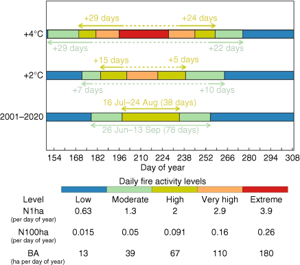
Lengthening of the fire and high fire seasons
The reference and future (+2 and +4°C) seasonal extents of the fire niche are shown in Fig. 6. The historical lengths of the fire and high-fire seasons were 78 and 38 days, respectively. The length of the high fire season would increase by between 20 and 53 days (from 17 June to 16 September in the worst scenario), with a slightly more pronounced lengthening at the beginning than at the end of the season. Very high and extreme levels would emerge at +2 and +4°C, respectively. Extreme days would occur during 33 days with +4°C (Fig. 5b), which is close to the historical high fire season length (38 days), highlighting the major intensification of activity in the core of the season, switching from ‘high’ to ‘extreme’ levels.
|
Relative contributions of intensification, expansion and seasonal lengthening in changes in spatiotemporal distributions of fire activity induced by climate change
Spatial expansion and seasonal lengthening revealed a strong extension of the fire niche, which does not necessarily imply that the major part of future increases in fire activity would occur outside the historical fire niche.
Fig. 7a shows anomalies of N100ha, partitioned inside and outside the historical fire-prone region. Approximately two-thirds of climate change-induced large fires would occur from intensification inside the historical fire region (which covers only 28% of the territory), whereas only one-third would be caused by the spatial expansion of the fire-prone region. Moreover, one-third would occur within the historically highly fire-prone region, which covers 8% of the territory (Fig. 7c). This shows that the intensification inside the current fire niche, more than its spatial expansion, would be responsible for future increases in fire activity.

|
Fig. 7b, d show the anomalies of N100ha during days corresponding to historical fire and high fire seasons. Approximately half of the increases in large fires would occur from intensification during the historically high fire season, between 16 July and 24 August. Only 15% of increases would occur outside the historical fire season, before 26 June or after 13 September. Similar results were obtained for N1ha and BA (Supplementary Figs S4, S5), highlighting that lengthening would not be the major cause of increases in regional fire activity.
For more details regarding the distribution of historical and future fire activity metrics, the spatial and seasonal distributions of N1ha, N100ha, BA are reported in Supplementary materials.
Discussion
In this study, we projected regional fire activity in southeastern France, assessed the potential extension of the historical spatial-temporal fire niche (i.e. the expansion of fire-prone regions and the lengthening of fire seasons) and quantified the distribution of climate-induced fire activity inside and outside the fire niche. Our results suggest that fire activities are expected to dramatically increase in this region, up to +160% for BA and +180% for the number of large fires under the +4°C scenario. Although a significant extension of the spatial and temporal fire niche is predicted, our results highlighted that approximately two-thirds of the additional fire activity induced by global warming would be caused by an intensification inside the historical fire-prone region. Below, we discuss these results and their implications for the understanding of future fire regimes and fire management in southeastern France.
Projected trends in fire activity metrics
The projected increases in fire activity metrics were larger in relative terms than the projected changes in mean FWI and DSR – except for 1 ha fires (Fig. 3). This suggests that the mean seasonal DSR (also called SSR, seasonal severity rating), often used to estimate the difficulty to control fires and season length (Flannigan et al. 2013), and more generally assessments based on mean FWI (e.g. Chatry et al. 2010) could underestimate the effect of climate change on fire activity.
Furthermore, we found that the fastest growing metric is the number of fires larger than 100 ha, which is consistent with the steeper response to FWI of the probability to exceed 100 ha than for other thresholds (e.g. 1000 ha), especially in the 20–35 range (Pimont et al. 2021; Fig. 3b). One could have expected that larger fires and BA would increase the most. This may reflect that landscape factors, such as fuel continuity or natural barriers (Mediterranean Sea, riparian zones) induced a constraint on the development of very large fires. This constraint could be reduced in the future with the wildland expansion caused by agricultural abandonment (Abadie et al. 2018), which could increase fuel continuity.
Our study projects larger relative increases than a previous continental study (Amatulli et al. 2013), which projected a 129% increase in BA in Mediterranean France between 1985 and 2004 and the end of the 21th century under scenario A2, corresponding to +13% per decade. This is much lower than the +24% per decade projected in the present study under the RCP8.5 during 2010–2090. Such a deviation is not surprising as the two studies differ in many ways (climate models, temporal resolution, reference period, etc.). It is important to note, however, that the reference ‘historical’ BA used in Amatulli et al. (2013) – 20 200 ha for 1985–2004 – was much higher than in the present study (5010 ha for 2004–2019). This large discrepancy is primarily due to a drastic reduction in fire activity in the last decades after 1990, and then after 2003 (Supplementary Table S4). In the present study, all fire activity metrics would have been twice higher if we had used fire weather relationships corresponding to the period 1995–2003 (Pimont et al. 2021). This strong sensitivity of absolute projections to reference periods when atmosphere–fire relationships change rapidly shows that they should be considered with caution and that comparisons based on relative increase per decade are more consistent (Dupuy et al. 2020). Besides, compared with monthly or yearly correlative fire models, we expect our modelling framework to better account for the impact of marginal daily increases in fire weather and days with extreme fire weather than a mean state of seasonal forcing variables (Williams and Abatzoglou 2016), and for the critical interactions between human factors and fire weather (Balch et al. 2017), represented here through efficient spatial effects.
At regional scales such as southeastern France, uncertainty in fire activity pertaining to climate change are high, in agreement with previous studies (e.g. Boulanger et al. 2018). The approach of emission scenarios at selected time horizons (used in Amatulli et al. 2013) showed higher uncertainty than by global warming levels (used in Turco et al. 2018), as shown in Fig. 2. Such levels align with climate policies and provide insights into risk avoidance and the potential benefits of meeting international climate agreements. However, they induce uncertainties regarding the time frame, limiting the implications of impacts studies for adaptation policies. Moreover, our results show that uncertainties in fire activity metrics – although reduced – remain quite high at regional scales, despite the forced convergence of global predictions. These points suggest that the two approaches are complementary.
Spatiotemporal extension of the wildfire niche
A much larger part of the southeastern zone would be exposed to wildfire, with the fire-prone region increasing from 28% of the territory to 45% in 2050 and 67% in 2090 (in RCP 8.5; Supplementary Fig. S2). We found higher increases inside the fire niche, which seems consistent with projections for the whole of France (Fargeon et al. 2020), which reported the highest increase in fire danger in already fire-prone regions.
Our high fire season (16 July–24 August) was consistent with operational perceptions that report intense suppression activities typically starting on average mid-July. Attaining +4°C of global warming would lengthen such a high fire season from 17 June to 16 September. This lengthening concerns both the beginning and the end of the period, being even slightly more marked at the beginning. Such a two-ended lengthening is expected in many temperate ecoregions, in contrast to other regions where the fire season typically ends with the arrival of monsoonal precipitation, and little lengthening is observed at the end of the season (Barbero et al. 2015; Dong et al. 2022). Half of the additional fire activity generated by global warming would occur during the historical high fire season, demonstrating a significant intensification between 16 July and 24 August.
Implications
Whereas fire projection studies generally focus on the projections of fire activity metrics (Amatulli et al. 2013; Turco et al. 2018), our study provides estimates of how the increase will translate into an extension of the fire niche and how the increase will be distributed with respect to the historical fire niche.
Indeed, the extension of the spatiotemporal fire niche and intensification within have important and distinct implications for fire management.
First, the spatial expansion of the niche would reach large areas where wildfires have been very rare. Preparedness for wildfires (forest management, firefighting equipment, culture of risk) is less developed in these areas than where the fire risk is historically higher (near Mediterranean Coast). A reanalysis of past trends in fire activity suggests that the observed increase in fire weather has already resulted in a deterioration of the operational response in the western part of this area, historically less prone to fire that the eastern part (Castel-Clavera et al. 2022). This could indicate that the consequences of the future expansion could be amplified with respect to the historical fire niche, especially if a very significant expansion of prevention and control policies is not conducted.
Second, the lengthening of the fire season projected in our simulations would require prevention and suppression services to maintain their vigilance over a much longer period of time. This raises the issue of fatigue, which is already suspected to increase large fire potential according to operational staff. This is all the more important as large increases in fire season lengths are projected for +2°C, which would occur soon (near 2040) according to climate models (Supplementary Table S2).
Third, most fire activity induced by climate change will occur within the historical niche, which means more simultaneous fires to catch before escape as well as more large fires to manage. In particular, a few hot spots covering less than 2% of the region are projected to see extreme spatial fire activity levels for +4°C. Also, extreme seasonal levels – hence extreme days for regional operations – will emerge above this global temperature increase to represent one-third of the fire season. The present projections assume that the efficiency of current prevention and control policies will not deteriorate in an environment with more fires, higher fire intensity and a longer fire season. Moreover, other regions of France and of Europe would also experience an intensification or expansion (Turco et al. 2018), limiting the reallocation of additional and sustainable resources to southeastern France and to use the European Union (EU) Civil Protection mechanisms in the extreme days, as already observed with synchronous increase in fire danger in the USA (Abatzoglou et al. 2021a). It is therefore likely that fire suppression will not be sufficient to limit the impacts of fires and new approaches will have to be considered.
Limitations and future developments
Our estimates for future fire activity suffer from several limitations, which will be the subject of future research directions. First, we assumed that the fire–climate relationship remains constant over time, whereas strong shifts have been observed in southeastern France (Ruffault and Mouillot 2015; Evin et al. 2018; Pimont et al. 2021; Castel-Clavera et al. 2022). However, the regional changes in prevention and suppression policies are not easily translated into quantitative metrics (Castel-Clavera et al. 2022) or projected by current models. Second, our model relied on rating fire danger with the FWI, which is not fully consistent (Pimont et al. 2021). In particular, seasonal cycles of FWI and fire activity show a time lag at both ends of the fire season, which was empirically corrected in Firelihood (seasonal effect), but whether this empirical correction would hold in the future remains unclear. It is important to note, however, that on-going analyses suggest that the FWI would be the most efficient fire danger index among those currently available to rate the danger in southeastern France. A final limitation was that reburns were not explicitly considered. Even if fire return intervals remained quite long in 8-km pixels, local reburns can be frequent (Ganteaume and Barbero 2019). This impact was implicitly accounted for in the model, but the impact of reburn could change with a tripling of burnt areas and ultimately limit fuel availability. Future methodological developments could help to account for this phenomenon (e.g. Abatzoglou et al. 2021b), especially for applying our methodology to locations with more frequent reburns.
Supplementary material
Supplementary material is available online.
Data availability
Data sharing is not applicable as no new data were generated or analysed during this study.
Conflicts of interest
The authors declare no conflicts of interest.
Declaration of funding
This project was partly funded by the French Ministry of Agriculture, which funded the PhD of Hélène Fargeon, which was the starting point of the present research. This project has also received funding from the European Union’s Horizon 2020 research and innovation programme under grant agreement No. 101037419 (Fire-RES project).
Acknowledgements
The authors are grateful to the modelling groups and the CORDEX projects for making the climate data available and to Météo-France for availability of the SAFRAN reanalysis. We would like to thank Marion Toutchkov from the Fire Agency at French Forest Service for her valuable feedback on the paper (Agence DFCI, ONF).
References
Abadie J, Dupouey J-L, Avon C, Rochel X, Tatoni T, Bergès L (2018) Forest recovery since 1860 in a Mediterranean region: drivers and implications for land use and land cover spatial distribution. Landscape Ecology 33, 289–305.| Forest recovery since 1860 in a Mediterranean region: drivers and implications for land use and land cover spatial distribution.Crossref | GoogleScholarGoogle Scholar |
Abatzoglou JT, Juang CS, Williams AP, Kolden CA, Westerling AL (2021a) Increasing Synchronous Fire Danger in Forests of the Western United States. Geophysical Research Letters 48, e2020GL091377
| Increasing Synchronous Fire Danger in Forests of the Western United States.Crossref | GoogleScholarGoogle Scholar |
Abatzoglou JT, Battisti DS, Williams AP, Hansen WD, Harvey BJ, Kolden CA (2021b) Projected increases in western US forest fire despite growing fuel constraints. Communications Earth & Environment 2, 227
| Projected increases in western US forest fire despite growing fuel constraints.Crossref | GoogleScholarGoogle Scholar |
Amatulli G, Camia A, San-Miguel-Ayanz J (2013) Estimating future burned areas under changing climate in the EU-Mediterranean countries. Science of The Total Environment 450–451, 209–222.
| Estimating future burned areas under changing climate in the EU-Mediterranean countries.Crossref | GoogleScholarGoogle Scholar |
Andela N, Morton DC, Giglio L, Chen Y, van der Werf GR, Kasibhatla PS, DeFries RS, Collatz GJ, Hantson S, Kloster S, Bachelet D, Forrest M, Lasslop G, Li F, Mangeon S, Melton JR, Yue C, Randerson JT (2017) A human-driven decline in global burned area. Science 356, 1356–1362.
| A human-driven decline in global burned area.Crossref | GoogleScholarGoogle Scholar |
Balch JK, Bradley BA, Abatzoglou JT, Nagy RC, Fusco EJ, Mahood AL (2017) Human-started wildfires expand the fire niche across the United States. Proceedings of the National Academy of Sciences 114, 2946–2951.
| Human-started wildfires expand the fire niche across the United States.Crossref | GoogleScholarGoogle Scholar |
Barbero R, Abatzoglou JT, Larkin NK, Kolden CA, Stocks B (2015) Climate change presents increased potential for very large fires in the contiguous United States. International Journal of Wildland Fire 24, 892–899.
| Climate change presents increased potential for very large fires in the contiguous United States.Crossref | GoogleScholarGoogle Scholar |
Barbero R, Abatzoglou JT, Pimont F, Ruffault J, Curt T (2020) Attributing Increases in Fire Weather to Anthropogenic Climate Change Over France. Frontiers in Earth Science 8, 104
| Attributing Increases in Fire Weather to Anthropogenic Climate Change Over France.Crossref | GoogleScholarGoogle Scholar |
Bedia J, Herrera S, Camia A, Moreno JM, Gutiérrez JM (2014) Forest fire danger projections in the Mediterranean using ENSEMBLES regional climate change scenarios. Climatic Change 122, 185–199.
| Forest fire danger projections in the Mediterranean using ENSEMBLES regional climate change scenarios.Crossref | GoogleScholarGoogle Scholar |
Boulanger Y, Parisien M-A, Wang X (2018) Model-specification uncertainty in future area burned by wildfires in Canada. International Journal of Wildland Fire 27, 164–175.
| Model-specification uncertainty in future area burned by wildfires in Canada.Crossref | GoogleScholarGoogle Scholar |
Brogli R, Kroner N, Sorland SL, Luthi D, Schar C (2019) The role of Hadley circulation and lapse‐rate changes for the future European summer climate. Journal of Climate 32, 385–404. https://www.jstor.org/stable/26663088.
Cannon AJ (2018) Multivariate quantile mapping bias correction: an N-dimensional probability density function transform for climate model simulations of multiple variables. Climate Dynamics 50, 31–49.
| Multivariate quantile mapping bias correction: an N-dimensional probability density function transform for climate model simulations of multiple variables.Crossref | GoogleScholarGoogle Scholar |
Castel-Clavera J, Pimont F, Opitz T, Ruffault J, Dupuy J-L (2022) Disentangling the factors of spatio-temporal patterns of wildfire activity in south-eastern France. International Journal of Wildland Fire
| Disentangling the factors of spatio-temporal patterns of wildfire activity in south-eastern France.Crossref | GoogleScholarGoogle Scholar | [In press]
Chatry C, Le Gallou J, Le Quentrec M, Lafitte J, Laurens D, Creuchet D, Grelu J (2010) Rapport de la mission interministérielle ‘Changements climatiques et extension des zones sensibles aux feux de forêts’. Rapport Min. Alimentation Agriculture Pêche no. 1796. (Paris) [In French] Available at https://www.vie‐publique.fr/sites/default/files/rapport/pdf/104000494.pdf
Cos J, Doblas-Reyes F, Jury M, Marcos R, Bretonnière P-A, Samsó M (2022) The Mediterranean climate change hotspot in the CMIP5 and CMIP6 projections. Earth System Dynamics 13, 321–340.
| The Mediterranean climate change hotspot in the CMIP5 and CMIP6 projections.Crossref | GoogleScholarGoogle Scholar |
Dong C, Williams AP, Abatzoglou JT, Lin K, Okin GS, Gillespie TW, Long D, Lin Y-H, Hall A, MacDonald GM (2022) The season for large fires in southern California is projected to lengthen in a changing climate. Communications Earth & Environment 3, 22
| The season for large fires in southern California is projected to lengthen in a changing climate.Crossref | GoogleScholarGoogle Scholar |
Drobinski P, Da Silva N, Bastin S, Mailler S, Muller C, Ahrens B, Christensen OB, Lionello P (2020) How warmer and drier will the Mediterranean region be at the end of the twenty-first century? Regional Environmental Change 20, 78
| How warmer and drier will the Mediterranean region be at the end of the twenty-first century?Crossref | GoogleScholarGoogle Scholar |
Dupire S, Curt T, Bigot S, Fréjaville T (2019) Vulnerability of forest ecosystems to fire in the French Alps. European Journal of Forest Research 138, 813–830.
| Vulnerability of forest ecosystems to fire in the French Alps.Crossref | GoogleScholarGoogle Scholar |
Dupuy J, Fargeon H, Martin-StPaul N, Pimont F, Ruffault J, Guijarro M, Hernando C, Madrigal J, Fernandes P (2020) Climate change impact on future wildfire danger and activity in southern Europe: a review. Annals of Forest Science 77, 35
| Climate change impact on future wildfire danger and activity in southern Europe: a review.Crossref | GoogleScholarGoogle Scholar |
Evin G, Curt T, Eckert N (2018) Has fire policy decreased the return period of the largest wildfire events in France? A Bayesian assessment based on extreme value theory. Natural Hazards and Earth System Sciences 18, 2641–2651.
| Has fire policy decreased the return period of the largest wildfire events in France? A Bayesian assessment based on extreme value theory.Crossref | GoogleScholarGoogle Scholar |
Fargeon H, Pimont F, Martin-StPaul N, De Caceres M, Ruffault J, Barbero R, Dupuy J-L (2020) Projections of fire danger under climate change over France: where do the greatest uncertainties lie? Climatic Change 160, 479–493.
| Projections of fire danger under climate change over France: where do the greatest uncertainties lie?Crossref | GoogleScholarGoogle Scholar |
Flannigan M, Cantin AS, de Groot WJ, Wotton M, Newbery A, Gowman LM (2013) Global wildland fire season severity in the 21st century. Forest Ecology and Management 294, 54–61.
| Global wildland fire season severity in the 21st century.Crossref | GoogleScholarGoogle Scholar |
Fréjaville T, Curt T (2015) Spatiotemporal patterns of changes in fire regime and climate: defining the pyroclimates of south-eastern France (Mediterranean Basin. Climatic Change 129, 239–251.
| Spatiotemporal patterns of changes in fire regime and climate: defining the pyroclimates of south-eastern France (Mediterranean Basin.Crossref | GoogleScholarGoogle Scholar |
Ganteaume A, Barbero R (2019) Contrasting large fire activity in the French Mediterranean. Natural Hazards and Earth System Sciences 19, 1055–1066.
| Contrasting large fire activity in the French Mediterranean.Crossref | GoogleScholarGoogle Scholar |
Jones MW, Abatzoglou JT, Veraverbeke S, Andela N, Lasslop G, Forkel M, Smith AJP, Burton C, Betts RA, van der Werf GR, Sitch S, Canadell JG, Santín C, Kolden C, Doerr SH, Le Quéré C (2022) Global and regional trends and drivers of fire under climate change. Reviews of Geophysics 60, e2020RG000726
| Global and regional trends and drivers of fire under climate change.Crossref | GoogleScholarGoogle Scholar |
Koh J, Pimont F, Dupuy J-L, Opitz T (2023) Spatiotemporal wildfire modeling through point processes with moderate and extreme marks. Annals of Applied Statistics 17, 560–582.
| Spatiotemporal wildfire modeling through point processes with moderate and extreme marks.Crossref | GoogleScholarGoogle Scholar |
Kotlarski S, Keuler K, Christensen OB, Colette A, Déqué M, Gobiet A, Goergen K, Jacob D, Lüthi D, van Meijgaard E, Nikulin G, Schär C, Teichmann C, Vautard R, Warrach-Sagi K, Wulfmeyer V (2014) Regional climate modeling on European scales: a joint standard evaluation of the EURO-CORDEX RCM ensemble. Geoscientific Model Development 7, 1297–1333.
| Regional climate modeling on European scales: a joint standard evaluation of the EURO-CORDEX RCM ensemble.Crossref | GoogleScholarGoogle Scholar |
Mann ME (2004) On smoothing potentially non-stationary climate time series. Geophysical Research Letters 31, L07214
| On smoothing potentially non-stationary climate time series.Crossref | GoogleScholarGoogle Scholar |
Mann ME (2008) Smoothing of climate time series revisited. Geophysical Research Letters 35, L16708
| Smoothing of climate time series revisited.Crossref | GoogleScholarGoogle Scholar |
Pimont F, Fargeon H, Opitz T, Ruffault J, Barbero R, Martin-StPaul N, Rigolot E, Riviére M, Dupuy J-L (2021) Prediction of regional wildfire activity in the probabilistic Bayesian framework of Firelihood. Ecological Applications 31, e02316
| Prediction of regional wildfire activity in the probabilistic Bayesian framework of Firelihood.Crossref | GoogleScholarGoogle Scholar |
Resco de Dios V, Hedo J, Cunill Camprubí À, Thapa P, Martínez del Castillo E, Martínez de Aragón J, Bonet JA, Balaguer-Romano R, Díaz-Sierra R, Yebra M, Boer MM (2021) Climate change induced declines in fuel moisture may turn currently fire-free Pyrenean mountain forests into fire-prone ecosystems. Science of The Total Environment 797, 149104
| Climate change induced declines in fuel moisture may turn currently fire-free Pyrenean mountain forests into fire-prone ecosystems.Crossref | GoogleScholarGoogle Scholar |
Ruffault J, Mouillot F (2015) How a new fire-suppression policy can abruptly reshape the fire–weather relationship. Ecosphere 6, 199
| How a new fire-suppression policy can abruptly reshape the fire–weather relationship.Crossref | GoogleScholarGoogle Scholar |
Ruffault J, Mouillot F (2017) Contribution of human and biophysical factors to the spatial distribution of forest fire ignitions and large wildfires in a French Mediterranean region. International Journal of Wildland Fire 26, 498–508.
| Contribution of human and biophysical factors to the spatial distribution of forest fire ignitions and large wildfires in a French Mediterranean region.Crossref | GoogleScholarGoogle Scholar |
Ruffault J, Moron V, Trigo RM, Curt T (2017) Daily synoptic conditions associated with large fire occurrence in Mediterranean France: evidence for a wind-driven fire regime. International Journal of Climatology 37, 524–533.
| Daily synoptic conditions associated with large fire occurrence in Mediterranean France: evidence for a wind-driven fire regime.Crossref | GoogleScholarGoogle Scholar |
Ruffault J, Curt T, Moron V, Trigo RM, Mouillot F, Koutsias N, Pimont F, Martin-StPaul N, Barbero R, Dupuy J-L, Russo A, Belhadj-Khedher C (2020) Increased likelihood of heat-induced large wildfires in the Mediterranean Basin. Scientific Reports 10, 13790
| Increased likelihood of heat-induced large wildfires in the Mediterranean Basin.Crossref | GoogleScholarGoogle Scholar |
Senande-Rivera M, Insua-Costa D, Miguez-Macho G (2022) Spatial and temporal expansion of global wildland fire activity in response to climate change. Nature Communications 13, 1208
| Spatial and temporal expansion of global wildland fire activity in response to climate change.Crossref | GoogleScholarGoogle Scholar |
Taylor SW (2020) Atmospheric Cascades Shape Wildfire Activity and Fire Management Decision Spaces Across Scales − A Conceptual Framework for Fire Prediction. Frontiers in Environmental Science 8, 527278
| Atmospheric Cascades Shape Wildfire Activity and Fire Management Decision Spaces Across Scales − A Conceptual Framework for Fire Prediction.Crossref | GoogleScholarGoogle Scholar |
Turco M, Rosa-Cánovas JJ, Bedia J, Jerez S, Montávez JP, Llasat MC, Provenzale A (2018) Exacerbated fires in Mediterranean Europe due to anthropogenic warming projected with non-stationary climate-fire models. Nature Communications 9, 3821
| Exacerbated fires in Mediterranean Europe due to anthropogenic warming projected with non-stationary climate-fire models.Crossref | GoogleScholarGoogle Scholar |
Van Wagner CE (1987) ‘Development and structure of the Canadian Forest Fire Weather Index System’. 35 p. (Canada Communication Group Publ: Ottawa)
Vidal J-P, Martin E, Franchistéguy L, Baillon M, Soubeyroux J-M (2010) A 50-year high-resolution atmospheric reanalysis over France with the Safran system. International Journal of Climatology 30, 1627–1644.
| A 50-year high-resolution atmospheric reanalysis over France with the Safran system.Crossref | GoogleScholarGoogle Scholar |
Wang X, Wotton BM, Cantin AS, Parisien M-A, Anderson K, Moore B, Flannigan MD (2017) cffdrs: an R package for the Canadian Forest Fire Danger Rating System. Ecological Processes 6, 5
| cffdrs: an R package for the Canadian Forest Fire Danger Rating System.Crossref | GoogleScholarGoogle Scholar |
Williams AP, Abatzoglou JT (2016) Recent Advances and Remaining Uncertainties in Resolving Past and Future Climate Effects on Global Fire Activity. Current Climate Change Reports 2, 1–14.
| Recent Advances and Remaining Uncertainties in Resolving Past and Future Climate Effects on Global Fire Activity.Crossref | GoogleScholarGoogle Scholar |