

Predicting black spruce fuel characteristics with Airborne Laser Scanning (ALS)
H. A. Cameron A C , D. Schroeder B and J. L. Beverly AA Department of Renewable Resources, University of Alberta, Edmonton, AB T6G 2H1, Canada.
B Alberta Agriculture and Forestry, Wildfire Management Branch, Government of Alberta, Edmonton, AB T6H 3S5, Canada.
C Corresponding author. Email: hilary2@ualberta.ca
International Journal of Wildland Fire 31(2) 124-135 https://doi.org/10.1071/WF21004
Submitted: 7 January 2021 Accepted: 2 November 2021 Published: 14 December 2021
Journal Compilation © IAWF 2022 Open Access CC BY-NC-ND
Abstract
Wildfire decision support systems combine fuel maps with other fire environment variables to predict fire behaviour and guide management actions. Until recently, financial and technological constraints have limited provincial fuel maps to relatively coarse spatial resolutions. Airborne Laser Scanning (ALS), a remote sensing technology that uses LiDAR (Light Detection and Ranging), is becoming an increasingly affordable and pragmatic tool for mapping fuels across localised and broad areas. Few studies have used ALS in boreal forest regions to describe structural attributes such as fuel load at a fine resolution (i.e. <100 m2 cell resolution). We used ALS to predict five forest attributes relevant to fire behaviour in black spruce (Picea mariana) stands in Alberta, Canada: canopy bulk density, canopy fuel load, stem density, canopy height and canopy base height. Least absolute shrinkage and selection operator (lasso) regression models indicated statistically significant relationships between ALS data and the forest metrics of interest (R2 ≥0.81 for all metrics except canopy base height which had a R2 value of 0.63). Performance of the regression models was acceptable and consistent with prior studies when applied to test datasets; however, regression models presented in this study mapped stand attributes at a much finer resolution (40 m2).
Keywords: remote sensing, fire behaviour, boreal ecosystems, fuel, planning, fuel maps, LiDAR, airborne laser scanning.
Introduction
Wildfires consume live and dead biomass (i.e. fuels) that form the ground, surface and crown structures of a forested stand. Assemblages of fuel and non-fuel elements across space and their physical properties alone and in relation to each other define the fuel complex. Fuel properties such as chemistry, shape, size, and load or amount will vary naturally within forest ecosystems. Attributes that define the spatial relationship of individual fuel elements to each other such as vertical arrangement, horizontal distribution and compaction will also vary (Countryman 1972; Keane 2015). Fine-scale measurements of these varied fuel properties and attributes are largely limited to research conducted in localised areas such as experimental burning studies (e.g. Alexander et al. 2004) or laboratory experiments of fuel flammability typically designed to address one or more specific components of flammability proposed by Anderson (1970): ignitability, sustainability and combustibility (Varner et al. 2015). Fuel measurement using field sampling methods are resource- and time-intensive, which is impractical for collecting comprehensive inventories of fuel characteristics across vast and remote northern landscapes.
At landscape scales, fuels are typically mapped as categorical fuel types that represent fuel assemblages and related physical properties and spatial arrangement of fuels within major forested or open vegetated landcovers. In Canada, the Canadian Forest Fire Behaviour Prediction (FBP) System (Forestry Fire Danger Group Canada 1992) defines 16 standard fuel types that can be mapped using satellite images and forest inventory data commonly available at coarse resolutions across broad forest management areas. At finer spatial scales, statistical models have been developed to estimate canopy fuel characteristics from field-measured data (e.g. Cruz et al. 2003). Photo-load visual guides (e.g. Scott and Reinhardt 2005) have also been used to derive site-specific estimates of fuel loads without the need for time- and resource-intensive fuel sampling; however, it is difficult to apply these methods across broad spatial scales without interpolating fuel characteristics.
Fuel attributes, in combination with weather and topography, dictate the manner in which fires ignite, spread and extinguish and are therefore critical inputs to all fire behaviour models. The contribution of canopy fuels to combustion is of particular importance for fire behaviour prediction. Involvement of canopy fuels in combustion generates higher intensities than surface or ground fires and can be expected to result in fire behaviour conditions that exceed the capabilities of suppression crews working directly on the fire front (Alexander 1982; Hirsch et al. 1998). Canopy fuel attributes used to model the onset of crowning and potential for sustained crown fire spread include canopy height, canopy base height (CBH), canopy fuel load (CFL) and canopy bulk density (CBD) (Keane et al. 2001; Cruz et al. 2003). Canopy height affects wind trajectory and speed (Finney 1998), which will influence fire intensity and affect the distance embers travel aloft (Chuvieco et al. 2003). Canopy base height is the vertical distance between the ground and live foliage and is important for determining whether a surface fire will progress into a canopy fire (Van Wagner 1977). Canopy fuel load is the amount of fuel in the canopy per unit area that is available for combustion (Stocks et al. 2004) and is a determinant of fire intensity. Canopy bulk density describes the available canopy fuel per unit volume that affects the rate of fire spread (Van Wagner 1977; Chuvieco et al. 2003).
Advancements in remote sensing technologies provide an emerging means of quantifying fuel characteristics across broad areas at a level of detail and precision that far exceeds current fuel type categories and maps commonly derived from forest inventories and satellite imagery (e.g. Andersen et al. 2005). Airborne Laser Scanning (ALS), a form of remote sensing that utilises LiDAR (Light Detection and Ranging), and aerial imagery are both popular tools to characterise canopy fuels (e.g. Erdody and Moskal 2010; Bright et al. 2017); however, ALS is considered more accurate for describing forest characteristics (Erdody and Moskal 2010) because it penetrates through small openings in the canopy and can describe the three-dimensional structure of a forest (Vastaranta et al. 2012; White et al. 2016; Wu et al. 2016). Field measurements are almost always required as baseline data when developing vegetation models using remote sensing technologies and are also used to validate statistical models. Although field measurements will always be important, once confidence is achieved in a remote sensing model, vegetation data can be mapped at much higher resolution than possible with field sampling alone.
Pioneering work by Andersen et al. (2005) modelled the statistical relationship between ALS point clouds and field-measured fuel data. Numerous subsequent studies have developed ALS-based models for mapping forest fuel metrics across an area of interest (e.g. Erdody and Moskal 2010; Hermosilla et al. 2014; Botequim et al. 2019). Models that use ALS data to describe fine scale variability in fuel structure are species-specific and have yet to be developed for black spruce (Picea mariana) stands, a prominent stand type in boreal ecosystems that covers 2.7 million km2 of land within Canada (National Forest Inventory 2013). Predicting fire behaviour in black spruce forests is of particular importance because these stands support high intensity crown fires. In this paper, we investigate the relationship between ALS data and canopy fuel attributes measured in boreal black spruce stands in Alberta, Canada. We use least absolute shrinkage and selection operator (lasso) regression to model the relationship between ALS data and five canopy fuel attributes: canopy bulk density, canopy fuel load, stem density, canopy height and canopy base height. Implications for fuel mapping and fire behaviour modelling are discussed.
Methods
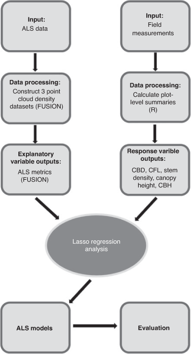
The objectives of this study were to develop statistical regression models for estimating canopy fuel characteristics from ALS data in black spruce forests. Field plots were established in black spruce stands and measured to calculate canopy height, stem density, CBH, CFL and CBD. Airborne Laser Scanning data were collected over the study sites and processed to produce metrics that were related to the field data using lasso regression. A schematic overview of the methods used in this study is shown in Fig. 1.
|
Study area
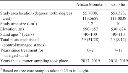
Pure black spruce stands were selected for analysis to represent a range of natural and managed stand structures characteristic of the boreal region. In this study, managed stands refer to forests that were subjected to thinning and pruning treatments to reduce potential fire behaviour, typically in the vicinity of values such as communities. In total, 79 circular fixed inventory plots were analysed at two study sites in north-western Alberta (Fig. 2) that afforded both ease of access and a broad range of managed and natural stand densities: Pelican Mountain (59 stands), a fuel and fire behaviour research site operated by Alberta Agriculture and Forestry (Fig. 3a); and Conklin (20 stands), a small hamlet surrounded by both natural and managed black spruce stands (Fig. 3b).

|

|
The structure of black spruce stands varies naturally from stringers in open bogs to open black spruce woodlands (<2000 stems ha−1) to very dense black spruce forests (>35 000 stems ha−1) (Jean et al. 2020). Managed stands approximate stand structures found in low density black spruce forests and were included in this study to provide a range of stand densities within the localised study area. Including managed stands in this study also allows for results to be applied to both natural and managed stand structures.
Characteristics of the Pelican Mountain and Conklin study sites are detailed in Table 1. Plot locations were selected using satellite imagery and site visits. Sample plots were located in varied stand structural conditions associated with natural, recently managed (1–2 years post-treatment) and older managed (7–17 years post-treatment) stands of pure black spruce. Dead branches draped with bearded lichens were common, and tree crowns in unmanaged stands extended to or near the ground. Forest floor conditions within the plots was often a nearly continuous cover of feather mosses, dominated by big red stem moss (Pleurozium schreberi) with occasional small hummocks of sphagnum moss, primarily common brown sphagnum (Sphagnum fuscum). Surface vegetation was dominated by Labrador tea (Ledum groenlandicum), lowbush cranberry (Vaccinium vitis-idaea), blueberry (Vaccinium myrtilloides) and bog cranberry (Vaccinium oxycoccos). Downed woody debris was largely absent in the natural stands, with a moderate presence in treated stands. Most sites had a thick organic layer, often >40 cm in depth.
|
Field measurements
At each plot, all trees with a height >1.3 m were measured to record species, status (live or dead), tree height, diameter at 1.3 m (DBH, diameter breast height), and the vertical distance between the ground and the base of live crown foliage. All height measurements were collected using a Haglöf Sweden® Vertex instrument, and DBH was measured using tree callipers. All vegetation with a height <1.3 m was deemed part of the surface or ladder fuel complex and omitted from canopy fuel measurements. The 1.3 m height threshold used to demarcate the lower limit of the canopy fuel strata is lower than the 2 m threshold used in other studies (e.g. Alexander and Cruz 2014), owing to the relatively short stature of the black spruce stands under investigation. The default sampling radius for ground plots was 3.57 m (76 plots). A larger 5.64 m radius was used when <20 trees occurred within the default sampling area (3 plots). Plot positions were determined to an average horizontal accuracy of 0.39 m using a Trimble® Geo7X global navigation satellite system device with a Trimble® Tempest Antenna (Sunnyvale, CA).
Field measurements were used to calculate plot-level canopy fuel attributes with the statistical software package R (R Core Team 2018). Canopy height (m) was defined as the tallest tree within the sampling area. Maximum tree height was used to represent stand height in this forest type due to the small plot size and presence of abundant small and stunted trees. Canopy base height (m) was calculated following Van Wagner (1977) as the average live crown base height for all live trees within the sampling area. Stem density (stems ha−1) was calculated as the sum of all trees >1.3 m in height divided by the plot area.
Canopy fuel load (CFL, kg m−2) was defined as the canopy biomass per unit area available for combustion during the flaming stage of a passing canopy fire. Foliage and fine branchwood less than 1.0 cm in diameter were included in the CFL calculations following Stocks et al. (2004). Published allometric equations based on DBH and species type were used to calculate the mass of available canopy fuel for each tree over 1.3 m in height (Table 2). Canopy fuel load (kg m−2) for the plot was then calculated as follows (Eqn 1):

where CFi is the mass (kg) of canopy fuel contributed by an individual tree and a is the sampling area of the plot (m2). For dead trees, dead branchwood less than 1.0 cm was included in the calculation, but it was assumed that no foliage was present. Occasionally, conifer species other than black spruce were within the sample plots. Conifer species included in canopy fuel load calculations and associated allometric equations are listed in Table 2. Broadleaved trees do not contribute to canopy fuel load and were omitted from analysis.

|
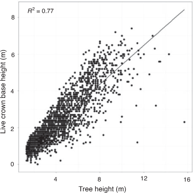
Allometric equations for estimating crown fuel load are representative of natural, unmanaged crown morphology. In managed stands, where pruning is used to remove crown fuels on the lower portion of the tree bole, estimated crown fuel load was reduced proportionate to the reduction in crown length following fuel treatments. Post-treatment crown length was calculated from field measurements as the difference between tree height and crown base height. Pre-treatment crown length was estimated from the statistical relationship between tree height and live crown base height (Fig. 4), which was derived with linear regression from data collected in natural, unmanaged black spruce stands at Pelican Mountain and Conklin (Eqn 2):

where CBHni (m) is the estimated pre-treatment, natural crown base height of an individual tree and hi is tree height (m). The equation used to estimate crown fuel load of pruned trees in managed stands is as follows (Eqn 3):

where CFpi is the mass (kg) of canopy fuel following pruning for the ith tree, CFni is the mass (kg) of canopy fuel given an unpruned, natural tree crown and the allometric equations from Table 2, and CBHpi is the field-measured post-treatment crown base height (m) following pruning.
|
Canopy bulk density (CBD, kg m−3) is the amount of fuel available for combustion during the passage of the fire front per unit volume and was calculated following the same methodology as the Fire and Fuels Extension to the Forest Vegetation Simulator (FFE-FVS) (Reinhardt and Crookston 2003; Rebain et al. 2010). For each individual tree, a uniform distribution of fuels was assumed between the crown base height and height of the tree. Using the crown position above the ground, the fuel density for all trees within the plot was summed in 0.3 m horizontal increments from the ground to the top of the canopy. Canopy bulk density was defined as the maximum 4.6 m running mean of crown fuel density for the plot, as per FFE-FVS. It should be noted that the FFE-FVS only counts conifer trees over 1.8 m tall towards canopy fuels (Rebain et al. 2010). In this study, a slightly shorter threshold of 1.3 m was used because black spruce stands are typically stunted due to poor growing conditions, yet smaller trees still contribute significantly to the canopy (Johnston et al. 2015).
Airborne Laser Scanning data
Discrete return multi-spectral ALS data were acquired for both study sites in August 2018 using a Teledyne Optech Titan multispectral sensor mounted on a Piper Navajo aircraft. This system emits 3 independent laser pulses in the 1550 nm (short wave infrared), 1064 nm (near infrared) and 532 nm (green) wavelengths. Metadata for the LiDAR system settings, flight parameters and data are shown in Table 3. The University of Lethbridge ARTEMis laboratory collected and preprocessed the data using the LiDAR Mapping Suite (LMS, proprietary software from Teledyne Optech) to generate a point cloud for each channel. The point clouds for each dataset were merged into a single dataset using the MergeData tool in FUSION (Version 3.80, McGaughey 2018a), an open source software specialised for LiDAR data processing. The GridSurfaceCreate tool within FUSION was used to generate a 1-m resolution digital elevation model (DEM) with returns that were classified as ground points. The elevation of ALS returns were calculated to height above the ground by subtracting the elevation from the DEM. The mean point density of the ALS datasets were 10.5 pulses per m2 and 11.3 pulses per m2 for Pelican Mountain and Conklin, respectively.

|
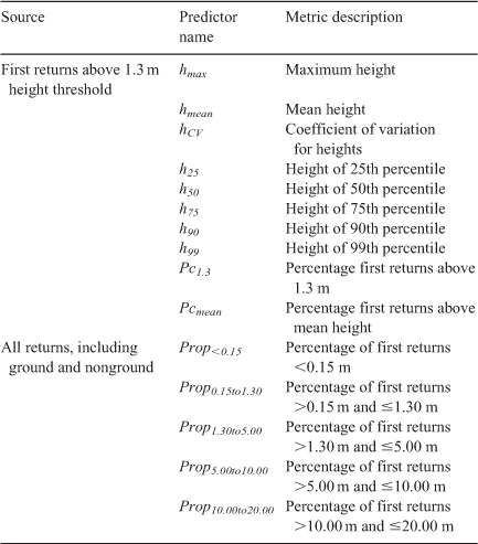
Processing and analysis of ALS data was generally consistent with procedures and recommendations outlined in White et al. (2013, 2017). The FUSION PolyClipData tool was used to cut ALS point clouds to each sample plot boundary. Airborne Laser Scanning point coordinates were transformed to height above ground with the DEM to enable comparisons across sample plots. Plot metrics were calculated using the CloudMetrics tool in FUSION. Procedures for calculating plot metrics are detailed in the FUSION software manual (McGaughey 2018b). Returns of LiDAR pulses <1.3 m above ground were excluded to restrict data points to the canopy fuel stratum under analysis. Fifteen candidate ALS variables known to have relationships with forestry metrics from previous studies (e.g. Andersen et al. 2005; Erdody and Moskal 2010; Bright et al. 2017) were calculated with FUSION and output in the plot-level ALS metrics dataset (Table 4). ALS-based predictor variables consisted of a variety of height and strata metrics.
|
Model development and evaluation
We applied lasso regression in R with the ‘glmnet’ package (Friedman et al. 2010) to model the relationship between ALS point cloud metrics and canopy characteristics estimated from field measurements. Lasso (i.e. least absolute shrinkage and selection operator) was chosen for this analysis because it uses shrinkage (which reduces the coefficients of the variables) to generate simple prediction models that account for collinearity between predictor variables (Tibshirani 1996; Babyak 2004). To satisfy the assumptions of linearity between the dependent and independent variables, a square root transformation was applied to CFL, CBD, stem density and CBH. Sample plots were randomly pooled into training (52 plots) and validation (27 plots) datasets. A linear regression model was fitted to each response variable (stand height, sqrtCFL, sqrtCBD, sqrtDensity and sqrtCBH) in the training dataset using the cv.glmnet function. To enable reproducible results, the set.seed value was set to ‘123’. The set.seed function divides the data into training and testing datasets randomly, but by setting a value (i.e. 123) it ensures the training and testing datasets are always composed of the same data subset each time the script is executed. When performing lasso regression, λ is used to determine the amount of shrinkage of the coefficients. When λ is zero, the resulting regression model is equivalent to least square estimates. As the value of λ increases, shrinkage occurs so variables that are not good predictors can be removed from the regression model. To obtain the optimal value for lambda, 10-fold cross validation with mean squared error was used. Performance of each regression model was evaluated on the training and testing data using the coefficient of determination (R2, R2test) and root mean squared error (RMSE, RMSEtest). Similar values between the training and testing data indicate that the regression model has good predictive capabilities.
Results
Field measurements of canopy and stand characteristics are summarised in Table 5. Both sites captured a wide range of stand characteristics, and there was sufficient overlap between natural and managed stand attributes. Selected regression models for estimating each canopy fuel attribute are shown in Table 6. Regression models for all stand attributes except CBH performed well, with R2 values ranging 0.81–0.89 for the training dataset and 0.78–0.85 for the test dataset. The RMSE and RMSEtest values are also close enough to conclude that all regression models except for CBH are suitable for generalised use whereby predictions are generated with new data that was not used in the modelling process.

|

|
Scatter plots of observed versus predicted values (Fig. 5) further confirmed goodness of fit. Data points for natural and managed stands exhibited a consistent trend and were therefore grouped for analysis. Data points for all regression models apart from stem density and CBH exhibited symmetrical scatter around the 1:1 line of perfect agreement, indicating good model fit. The stem density regression model showed bias towards underpredicting high field-measured values. This bias was also slightly apparent with the CBD and CFL regression models. The canopy height regression model showed some bias at overpredicting low field-measured values (<7.5 m). The scatter plot for the CBH regression model shows significant scatter around the 1:1 line indicating poor predictive ability.

|
The regression models derived in this study can produce significantly more detailed forest structure maps compared to the FBP fuel type maps (Fig. 6a). Photographs of canopy structure taken from the field sampling plots indicate that the models are able to correctly capture the natural variability of canopy bulk density in black spruce stands (Fig. 6b, c).

|
Discussion
Black spruce stands can be found in abundance in all Canadian provinces and territories (National Forest Inventory 2013). The black spruce stands analysed in this study represent typical black spruce stands observed throughout the boreal forest (Forestry Fire Danger Group Canada 1992; Johnston et al. 2015). Results indicate that ALS data are able to describe black spruce forest structure characteristics important to wildfire behaviour at a fine scale. Five canopy metrics of interest were evaluated in this study (CFL, CBD, canopy height, stem density and CBH), and all models comparing field-measured data to ALS metrics had R2 values ≥ 0.81 except for CBH which had an R2 value of 0.63. The ability to use these statistical models and ALS data to map fuels at a fine resolution could have profound impacts for fire management practices and the underlying fire research and decision support tools that guide them. Availability of detailed fuel attributes will enable development of new empirical models that relate ALS-derived forest structural attributes to observed fire occurrence and fire behaviour. Ongoing enhancements to the Canadian Forest Fire Behaviour Prediction (FBP) System (Canadian Forest Service Fire Danger Group 2021) have been designed to accommodate new and emerging sources of information about forest structure and composition that could be supplied by ALS-generated fuel maps. High resolution fuel maps could also be used to inform strategic fire risk assessments and prioritise proactive mitigation measures such as fuel treatments, as well as monitor forest structural changes over time and in response to management actions. Similar studies completed for other forest types have reported varying degrees of success when comparing ALS data with field-based measurements of forest characteristics important to wildfire (Table 7); however, results of this study were designed to map forest attributes at a much finer scale (40 m2 resolution) compared with the published studies listed in Table 7. Regression models performed similarly or better than those estimated for other stand types in prior studies with the exception of the CBH regression model, which performed poorly in comparison. The canopy height regression model performed similarly to other studies but not as well as expected. Given the relatively high density of the ALS data we had expected R2 values similar to those derived in Andersen et al. (2005) and Erdody and Moskal (2010) studies (i.e. >0.90). This may reflect the shorter canopy heights of the black spruce stands included in the present study, which had an average stand height of 9.3 m compared with average stand heights >11.9 m associated with the forest types investigated in the studies listed in Table 7.

|
CBD, CFL and stem density regression models under-predicted at the high-end range of values (Fig. 5). This may be an artefact of the lasso method, which shrinks the coefficients to create a ‘flatter’ model. This introduces a small amount of bias with the objective of decreasing the variance of the model and increasing predictive power. It could also be due to other factors, given that prior studies that related ALS data to CBD and CFL also under-predicted at the high-end range of values, even when lasso regression was not employed. For example, Hermosilla et al. (2014) reported similar findings in predictions of CBD from ALS data in mixedwood forests and suggested the underprediction was caused by outliers. Predicted versus observed CBD values reported by Erdody and Moskal (2010) and Andersen et al. (2005) also exhibited underprediction at the high end of the range. These discrepancies could also be due to the nature of forest structure and ALS data. In very dense stands, which would be associated with high values of CFL and CBD, the ALS laser pulse will be obscured by the continuous upper canopy vegetation, inhibiting reflectance and leading to occlusion of data at lower elevations (e.g. Vauhkonen et al. 2012; Kandare et al. 2016). Further studies of how stand density impacts occlusion in black spruce stands are required to confirm the underlying factors responsible for underprediction of CBD and CFL from ALS and potentially correct any inherent bias through data transformation (e.g. Lefsky et al. 2002).
Underprediction at the high-end values could also be due to the use of fixed interval height metrics. For example, if dense stands happen to be stunted, then ALS metrics such as the percent of first returns above 1.3 m (Pc1.3) may be smaller than that for taller stands. This would occur when the ALS laser pulse has a shorter travel distance through the canopy to reach the height threshold. Given the volume of ALS models that have been developed using height strata values (e.g. Andersen et al. 2005; Erdody and Moskal 2010; Bright et al. 2017; Engelstad et al. 2019), more research is needed to investigate the effects of fixed height variables on model results.
Results of this study confirm the widely acknowledged limitation of ALS data for predicting stem density (e.g. Kandare et al. 2016). In addition to underprediction of high-density field-measured values, the relatively large differences between the RMSE and RMSEtest values for the stem density regression model indicate overfitting of the training dataset. Despite these issues, the R2test values were similar or better than those reported by Treitz et al. (2012) and Luther et al. (2014), who both related ALS data to black spruce forest characteristics in eastern Canada.
Despite prior studies successfully predicting CBH using ALS data, our results indicated the success of a CBH regression model likely depends on vegetation type. When the understorey vegetation is close to the base of the canopy, it can be difficult to define CBH using ALS (Popescu and Zhao 2008). Black spruce trees tend to have crowns that extend to the forest floor with a build-up of dead branches and lichen. The relatively poor CBH regression model generated support that ALS data is not well suited for measuring the distance between the ground and the base of the canopy in stands where tree morphology includes crown vegetation that extends continuously from the top of the tree to the forest floor. Given that vertical fuel connectivity in black spruce dominated stands is a determinant of wildfire behaviour, future studies could focus on relating ALS to the vertical continuity of canopy fuels, rather than CBH. It would also be beneficial for future studies to explore the use of ALS to predict surface fuel loads (e.g. Stefanidou et al. 2020).
It is also noteworthy that the CFL, canopy height and CBH regression models had smaller RMSEtest values compared with RMSE values. Although differences were small, this was unusual given that the regression model was designed to fit the training data best. The lower testing errors may indicate that the regression models were generalising well and were able to properly adapt to new data. It could also reflect the relatively small size of the testing data and random chance. If the testing error was much larger than the training error, it could indicate that the training and testing groups were not randomly selected. Given that the errors were similar in value, this was likely not the case for the regression models developed in this study and it can be assumed that the low testing errors were due to random chance.
Although results of this study are promising, sources of error for this research include the following: human error during field measurements; the influence of plot edge effects and the assumption of stand homogeneity (White et al. 2013); use of allometric equations to calculate canopy fuel load values; and the time elapsed between field measurements and ALS data collection. The small plot size used in this study, which allowed for the high resolution of the produced models (White et al. 2017), increased the influence of edge effects due to the higher perimeter to area ratio. The strong observed relationships between field measurements and ALS metrics suggests the small plot size was acceptable for our black spruce stands that have a narrow columnar crown morphology, which may not be the case for other stand types.
Given the prevalence of black spruce across Canada (National Forest Inventory 2013), we expect the models developed in this study to be suitable for applied use by researchers and fire managers for estimating stand structure in similar black spruce ecosystems with structural characteristics that fall within the range of variability observed in our source data. Stand structural characteristics present at Pelican Mountain and Conklin research sites are unlikely to represent the full range of variability in black spruce stands in the Canadian boreal forest. To improve the robustness of the regression models, additional plots could be collected for black spruce stands with a wider range of structural variability. A larger sample size of field measurements would also be expected to reduce bias observed in some of the predictive regression models.
In conclusion, the results of this study indicate that ALS data are a viable resource for predicting forest structural characteristics important to wildfire behaviour in black spruce stands. Timely and cost-effective mapping of canopy fuel characteristics across large landscape areas could have a profound impact on fire management practices and the underlying fire research and decision support tools that guide them. This study confirmed the potential to utilise ALS data to map canopy fuels in black spruce forests at higher resolution than ever before. These data could eventually be used to develop empirical models predicting fire behaviour and fire occurrence, and for strategic planning. Management applications include documenting fuel structure changes over time, prioritising stands for fuel treatments based on stand structure, and documenting pre- and post-treatment stand structure to determine whether hazard reduction targets have been met. Mapping forest structure to the level of detail analysed in this study could also have profound impact in areas of research beyond wildfire management. For example, canopy fuel information derived from the models presented in this study could be used to assess habitat suitability or ecological impacts of disturbances (i.e. insect attack, wind damage, disease epidemics) or to analyse post-harvest forest structure.
Data availability
The data that support the findings of this study are available from the corresponding author upon reasonable request.
Conflicts of interest
Jen Beverly is an Associate Editor of International Journal of Wildland Fire but was blinded from the peer-review process for this paper.
Declaration of funding
This research was funded by Alberta Agriculture and Forestry through the Canadian Partnership for Wildland Fire Science, grant agreement number 18GRWMB06.
Acknowledgements
This research was funded by Alberta Agriculture and Forestry through the Canadian Partnership for Wildland Fire Science, grant agreement number 18GRWMB06. Alberta Agriculture and Forestry assisted with the field data collection for this project. C. Hopkinson and L. Chasmer (University of Lethbridge) collected the airborne LiDAR data. M. Okhrimenko (University of Lethbridge) helped with preprocessing of airborne LiDAR data. C. Bater (Alberta Agriculture and Forestry) provided helpful discussions on airborne data collection and processing.
References
Alexander ME (1982) Calculating and interpreting forest fire intensities. Canadian Journal of Botany 60, 349–357.| Calculating and interpreting forest fire intensities.Crossref | GoogleScholarGoogle Scholar |
Alexander ME, Cruz MG (2014) Tables for estimating canopy fuel characteristics from stand variables in four interior west confier forest types. Forest Science 60, 784–794.
| Tables for estimating canopy fuel characteristics from stand variables in four interior west confier forest types.Crossref | GoogleScholarGoogle Scholar |
Alexander ME, Stefner CN, Mason JA, Stocks BJ, Hartley GR, Maffey ME, Wotton BM, Taylor SW, Lavoie N, Dalrymple GN (2004) Characterizing the jack pine–black spruce fuel complex of the International Crown Fire Modelling Experiment (ICFME). Canadian Forest Service Information Report NOR-X-393. (Edmonton, AB)
Andersen H, McGaughey RJ, Reutebuch SE (2005) Estimating forest canopy fuel parameters using LIDAR data. Remote Sensing of Environment 94, 441–449.
| Estimating forest canopy fuel parameters using LIDAR data.Crossref | GoogleScholarGoogle Scholar |
Anderson HE (1970) Forest fuel ignitibility. Fire Technology 6, 312–319.
| Forest fuel ignitibility.Crossref | GoogleScholarGoogle Scholar |
Babyak MA (2004) What you see may not be what you get: A brief, nontechnical introduction to overfitting in regression-type models. Psychosomatic Medicine 66, 411–421.
| What you see may not be what you get: A brief, nontechnical introduction to overfitting in regression-type models.Crossref | GoogleScholarGoogle Scholar | 15184705PubMed |
Botequim B, Fernandes PM, Borges JG, González-Ferreiro E, Guerra-Hernández J (2019) Improving silvicultural practices for mediterranean forests through fire behaviour modelling using LiDAR-derived canopy fuel characteristics. International Journal of Wildland Fire 28, 823–839.
| Improving silvicultural practices for mediterranean forests through fire behaviour modelling using LiDAR-derived canopy fuel characteristics.Crossref | GoogleScholarGoogle Scholar |
Bright BC, Hudak AT, Meddens AJH, Hawbaker TJ, Briggs JS, Kennedy RE (2017) Prediction of forest canopy and surface fuels from lidar and satellite time series data in a bark beetle-affected forest. Forests 8, 322
| Prediction of forest canopy and surface fuels from lidar and satellite time series data in a bark beetle-affected forest.Crossref | GoogleScholarGoogle Scholar |
Canadian Forest Service Fire Danger Group (2021). An overview of the next generation of the Canadian Forest Fire Danger Rating System (Information Report GLC-X-26). National Resources Canada, Great Lakes Forestry Centre, Sault Ste. Marie. (Ontario, Canada).
Chuvieco E, Riaño D, Van Wagtendok J, Morsdof F (2003) Fuel loads and fuel type mapping. In ‘Wildland fire danger estimation and mapping: The role of remote sensing data’. (Ed. E Chuvieco) pp. 119–142. (World Scientific)
Countryman CM (1972) The fire environment concept. USDA Forest Service, Pacific Southwest Range and Experiment Station. (Berkeley, CA)
Cruz MG, Alexander ME, Wakimoto RH (2003) Assessing canopy fuel stratum characteristics in crown fire prone fuel types of western north america. International Journal of Wildland Fire 12, 39–50.
| Assessing canopy fuel stratum characteristics in crown fire prone fuel types of western north america.Crossref | GoogleScholarGoogle Scholar |
Engelstad PS, Falkowski M, Wolter P, Poznanovic A, Johnson P (2019) Estimating canopy fuel attributes from low-density LiDAR. Fire (Basel, Switzerland) 2, 38
| Estimating canopy fuel attributes from low-density LiDAR.Crossref | GoogleScholarGoogle Scholar |
Erdody TL, Moskal LM (2010) Fusion of LiDAR and imagery for estimating forest canopy fuels. Remote Sensing of Environment 114, 725–737.
| Fusion of LiDAR and imagery for estimating forest canopy fuels.Crossref | GoogleScholarGoogle Scholar |
Finney MA (1998) FARSITE: Fire Area Simulator-Model development and evaluation. USDA Forest Service, Rocky Mountain Research Station Research Paper RMRS-RP-4. (Ogden, UT)
Forestry Fire Danger Group Canada (1992). Development and structure of the Canadian Forest Fire Behavior Prediction System (Information Report ST-X-3). Forestry Canada, Headquarters, Fire Danger Group and Science and Sustainable Development Directorate. (Ottawa, Canada)
Friedman J, Hastie T, Tibshirani R (2010) Regularization Paths for Generalized Linear Models via Coordinate Descent. Journal of Statistical Software 33, 1–22.
| Regularization Paths for Generalized Linear Models via Coordinate Descent.Crossref | GoogleScholarGoogle Scholar | 20808728PubMed |
González-Olabarria J, Rodríguez F, Fernández-Landa A, Mola-Yudego B (2012) Mapping fire risk in the model forest of urbión (spain) based on airborne LiDAR measurements. Forest Ecology and Management 282, 149–156.
| Mapping fire risk in the model forest of urbión (spain) based on airborne LiDAR measurements.Crossref | GoogleScholarGoogle Scholar |
Hermosilla T, Ruiz LA, Kazakova AN, Coops NC, Moskal LM (2014) Estimation of forest structure and canopy fuel parameters from small-footprint full-waveform LiDAR data. International Journal of Wildland Fire 23, 224–233.
| Estimation of forest structure and canopy fuel parameters from small-footprint full-waveform LiDAR data.Crossref | GoogleScholarGoogle Scholar |
Hirsch KG, Corey PN, Martell DL (1998) Using expert judgment to model initial attack fire crew effectiveness. Forest Science 44, 539–549.
| Using expert judgment to model initial attack fire crew effectiveness.Crossref | GoogleScholarGoogle Scholar |
Jean SA, Pinno BD, Nielsen SE (2020) Early Regeneration Dynamics of Pure Black Spruce and Aspen Forests after Wildfire in Boreal Alberta, Canada. Forests 11, 333
| Early Regeneration Dynamics of Pure Black Spruce and Aspen Forests after Wildfire in Boreal Alberta, Canada.Crossref | GoogleScholarGoogle Scholar |
Johnson AF, Woodard PM, Titus SJ (1990) Lodgepole pine and white spruce crown fuel weights predicted from diameter at breast height. Forestry Chronicle 66, 596–599.
| Lodgepole pine and white spruce crown fuel weights predicted from diameter at breast height.Crossref | GoogleScholarGoogle Scholar |
Johnston DC, Turetsky MR, Benscoter BW, Wotton BM (2015) Fuel load, structure, and potential fire behaviour in black spruce bogs. Canadian Journal of Forest Research 45, 888–899.
| Fuel load, structure, and potential fire behaviour in black spruce bogs.Crossref | GoogleScholarGoogle Scholar |
Kandare K, Ørka HO, Chan JCW, Dalponte M (2016) Effects of forest structure and airborne laser scanning point cloud density on 3D delineation of individual tree crowns. European Journal of Remote Sensing 49, 337–359.
| Effects of forest structure and airborne laser scanning point cloud density on 3D delineation of individual tree crowns.Crossref | GoogleScholarGoogle Scholar |
Keane RE (Ed.) (2015) ‘Wildland fuel fundamentals and application’. (Springer: New York)
Keane RE, Burgan R, van Wagtendonk J (2001) Mapping wildland fuels for fire management across multiple scales: integrating remote sensing, GIS, and biophysical modeling. International Journal of Wildland Fire 10, 301–319.
| Mapping wildland fuels for fire management across multiple scales: integrating remote sensing, GIS, and biophysical modeling.Crossref | GoogleScholarGoogle Scholar |
Lefsky MA, Cohen WB, Harding DJ, Parker GG, Acker SA, Gower ST (2002) Lidar remote sensing of above‐ground biomass in three biomes. Global Ecology and Biogeography 11, 393–399.
| Lidar remote sensing of above‐ground biomass in three biomes.Crossref | GoogleScholarGoogle Scholar |
Luther JE, Skinner R, Fournier RA, Ovan Lier OR, Bowers WW, Coté J, Hopkinson C, Moulton T (2014) Predicting wood quantity and quality attributes of balsam fir and black spruce using airborne laser scanner data. Forestry 87, 313–326.
| Predicting wood quantity and quality attributes of balsam fir and black spruce using airborne laser scanner data.Crossref | GoogleScholarGoogle Scholar |
McGaughey RJ (2018a) FUSION/LDV (Computer Software) Available at: http://forsys.cfr.washington.edu/fusion/fusionlatest.html
McGaughey RJ (2018b) FUSION/LDV: Software for LIDAR data analysis and visualization. US Department of Agriculture, Forest Service, Pacific Northwest Research Station. (Seattle, WA)
National Forest Inventory (2013) Canada’s National Forest Inventory, revised 2006 baseline. Natural Resources Canada. Victoria, B.C. Available at: https://nfi.nfis.org/en/standardreports [accessed September 2021].
Popescu SC, Zhao K (2008) A voxel-based lidar method for estimating crown base height for deciduous and pine trees. Remote Sensing of Environment 112, 767–781.
| A voxel-based lidar method for estimating crown base height for deciduous and pine trees.Crossref | GoogleScholarGoogle Scholar |
R Core Team (2018) R: A language and environment for statistical computing. (R Foundation for Statistical Computing: Vienna, Austria) Available at: https://www.R-project.org/.
Rebain SA, Reinhardt ED, Crookston NL, Beukema SJ, Kurz WA, Greenough JA, Robinson DCE, Lutes DC (2010) The fire and fuels extension to the forest vegetation simulator: Updated model documentation. US Department of Agriculture, Forest Service, Forest Management Service Center. (Fort Collins, CO)
Reinhardt E, Crookston NL (Tech. Eds) (2003) The Fire and Fuels Extension to the Forest Vegetation Simulator. USDA Forest Service, Rocky Mountain Research Station, General Technical Report RMRS-GTR-116. (Ogden, UT)
Scott JH, Reinhardt ED (2005) Stereo photo guide for estimating canopy fuel characteristics in conifer stands. USDA Forest Service, Rocky Mountain Research Station, General Technical Report RMRS-GTR-145. (Fort Collins, CO)
Skowronski NS, Clark KL, Duveneck M, Hom J (2011) Three-dimensional canopy fuel loading predicted using upward and downward sensing LiDAR systems. Remote Sensing of Environment 115, 703–714.
| Three-dimensional canopy fuel loading predicted using upward and downward sensing LiDAR systems.Crossref | GoogleScholarGoogle Scholar |
Stefanidou A, Gitas IZ, Korhonen L, Georgopoulos N, Stavrakoudis D (2020) Multispectral lidar-based estimation of surface fuel load in a dense coniferous forest. Remote Sensing 12, 3333
| Multispectral lidar-based estimation of surface fuel load in a dense coniferous forest.Crossref | GoogleScholarGoogle Scholar |
Stocks BJ, Alexander ME, Wotton BM, Stefner CN, Flannigan MD, Taylor SW, Lavoie N, Mason JA, Hartley GR, Maffey ME, Dalrymple GN, Blake TW, Cruz MG, Lanoville RA (2004) Crown fire behaviour in a northern jack pine black spruce forest. Canadian Journal of Forest Research 34, 1548–1560.
| Crown fire behaviour in a northern jack pine black spruce forest.Crossref | GoogleScholarGoogle Scholar |
Tibshirani R (1996) Regression shrinkage and selection via the lasso. Journal of the Royal Statistical Society. Series B. Methodological 58, 267–288.
| Regression shrinkage and selection via the lasso.Crossref | GoogleScholarGoogle Scholar |
Treitz P, Lim K, Woods M, Pitt D, Nesbitt D, Etheridge D (2012) LiDAR sampling density for forest resource inventories in ontario, canada. Remote Sensing 4, 830–848.
| LiDAR sampling density for forest resource inventories in ontario, canada.Crossref | GoogleScholarGoogle Scholar |
Van Wagner CV (1977) Conditions for the start and spread of crown fire. Canadian Journal of Forest Research 7, 23–34.
| Conditions for the start and spread of crown fire.Crossref | GoogleScholarGoogle Scholar |
Varner JM, Kane JM, Kreye JK, Engber E (2015) The flammability of forest and woodland litter: a synthesis. Current Forestry Reports 1, 91–99.
| The flammability of forest and woodland litter: a synthesis.Crossref | GoogleScholarGoogle Scholar |
Vastaranta M, Kankare V, Holopainen M, Yu X, Hyyppä J, Hyyppä H (2012) Combination of individual tree detection and area-based approach in imputation of forest variables using airborne laser data. ISPRS Journal of Photogrammetry and Remote Sensing 67, 73–79.
| Combination of individual tree detection and area-based approach in imputation of forest variables using airborne laser data.Crossref | GoogleScholarGoogle Scholar |
Vauhkonen J, Ene L, Gupta S, Heinzel J, Holmgren J, Pitkänen J, Solberg S, Wang Y, Weinacker H, Hauglin KM, Lien V, Packalén P, Gobakken T, Koch B, Næsset E, Tokola T, Maltamo M (2012) Comparative testing of single-tree detection algorithms under different types of forest. Forestry 85, 27–40.
| Comparative testing of single-tree detection algorithms under different types of forest.Crossref | GoogleScholarGoogle Scholar |
White JC, Wulder MA, Varhola A, Vastaranta M, Coops NC, Cook BD, Pitt D, Woods M (2013) A best practices guide for generating forest inventory attributes from airborne laser scanning data using an area-based approach. Forestry Chronicle 89, 722–723.
| A best practices guide for generating forest inventory attributes from airborne laser scanning data using an area-based approach.Crossref | GoogleScholarGoogle Scholar |
White JC, Coops NC, Wulder MA, Vastaranta M, Hilker T, Tompalski P (2016) Remote sensing technologies for enhancing forest inventories: A review. Canadian Journal of Remote Sensing 42, 619–641.
| Remote sensing technologies for enhancing forest inventories: A review.Crossref | GoogleScholarGoogle Scholar |
White J, Tompalski P, Vastaranta M, Wulder MA, Saarinen N, Stepper C, Coops NC (2017) A model development and application guide for generating an enhanced forest inventory using airborne laser scanning data and an area-based approach. Natural Resources Canada, Pacific Forestry Center, CWFC Information Report FI-X-018. Available at: https://cfs.nrcan.gc.ca/publications?id=38945
Wu B, Yu B, Wu Q, Huang Y, Chen Z, Wu J (2016) Individual tree crown delineation using localized contour tree method and airborne LiDAR data in coniferous forests. International Journal of Applied Earth Observation and Geoinformation 52, 82–94.
| Individual tree crown delineation using localized contour tree method and airborne LiDAR data in coniferous forests.Crossref | GoogleScholarGoogle Scholar |