

Linking human activities to wildfires in Tsavo Conservation Area: a social-ecological study
Naftal G. Kariuki A B * , David O. Chiawo C , Eunice W. Kairu B , Jemimah A. Simbauni B and Amos C. Muthiuru D E
A
B
C
D
E
Abstract
The Tsavo Conservation Area (TCA) in Kenya has recently experienced severe wildfires, but there is scarce data on the factors contributing to these fires.
This study aimed to investigate the connection between human activities and wildfires in the region, which is divided into Tsavo East, Chyulu Hills, and Tsavo West National Parks.
A field survey conducted from July to December 2022 gathered data through questionnaires, interviews and focus groups. Data on burned areas (2002–2023) were obtained from MODerate Resolution Imaging Spectroradiometer (MODIS) MCD64A1 version 6. Analysis of Variance (ANOVA), chi-square and Kendall’s W tests were applied for analysis.
The findings indicated significant differences in the burned area proportions, where Chyulu Hills National Park experienced significant large burnt areas compared to the other two parks. A strong link was found between human activities and wildfires. Activities linked to wildfires included poaching, honey harvesting, charcoal burning and others, with poaching being most strongly linked. Additionally, activities like bhang farming and khat harvesting were recorded exclusively in Chyulu Hills National Park.
The findings suggest that areas with more activities experienced higher fire incidences.
The findings emphasise the need for policy changes that incorporate local communities in wildfire management.
Keywords: burned area, human activities, local communities, socio-ecological, socio-economic, Tsavo Conservation Area, wildfire management, wildfires.
Introduction
The role of wildfires in ecosystems is a topic of debate, as fire is an important ecological tool and can be destructive especially in critical ecosystems such as protected areas. Fires play a vital role in various ecosystems by enabling processes such as habitat maintenance and nutrient cycling. They are crucial in regulating species interactions, population sizes, community composition and organism traits (McLauchlan et al. 2020). Wildfires help shape vegetation structure and composition, which ultimately supports ecosystem biodiversity (He et al. 2019). Additionally, wildfires establish new habitats that allow for the emergence of fire-tolerant species of plants and animals (Pausas and Keeley 2019). On the other hand, uncontrolled and destructive fires pose significant threats to both the environment and human lives (Aponte et al. 2016; Dos Santos et al. 2021). These events, referred to by various names like bushfires, forest fires and wildland fires (Krah et al. 2020), can lead to severe ecological consequences, including the loss of flora and fauna, and alongside hurricanes, droughts and floods, are considered major natural disturbances (Kouassi et al. 2018; Colantoni et al. 2020). The vegetation destroyed by wildfires serves as habitat for many species, including those already at risk of extinction (Ward et al. 2020).
Human activities are the main cause of wildfires worldwide, accounting for approximately 80% of occurrences (Jain et al. 2021). For instance, in India, 98% of wildfire incidences are caused by human actions, the majority of which are linked to arson, negligence and unidentified causes (Jhariya and Raj 2014). An average of 8000 wildfires occurred in Canada annually from 1970 to 2017, leading to the destruction of over 2.25 million ha of land and displacing more than 125,000 people between 1998 and 2021 (Tymstra et al. 2020; Copes-Gerbitz et al. 2022). Likewise, in Zimbabwe, human activities such as pest management and land clearing are responsible for 95% of wildfire occurrences. These activities include preparing land for planting crops, burning plant remains for pest control and clearing virgin land. Other human livelihood activities include bee smoking, hunting, careless disposal of ashes as motorists take breaks along the roadside and improper disposal of cigarette butts after smoking (Choga and Nyamadzawo 2018).
In Kenya, the growing human population and settlements are increasing the resource demand. Such changes are driving people to move to areas with less population, particularly the southern region, including the Tsavo Conservation Area (TCA) (Muriuki et al. 2011). This migration has led to an increase in human settlements around the protected areas of Tsavo, raising the risk of wildfires. While fire has long been an important tool in many parts of the world, local ethnic communities often use fire in land management practices, including the intentional burning of grasslands to encourage regrowth for livestock (Muriuki et al. 2011; Croker et al. 2024). Additionally, poaching, agricultural practices and charcoal production contribute to wildfire ignition (Henry et al. 2019). Research indicates that the main human activities that trigger wildfires in the TCA are charcoal burning, honey harvesting and timber extraction (Kamau and Medley 2014). To manage wildfires effectively, especially in protected areas like the national parks in Tsavo, it is vital to comprehend the specific human activity that causes these fires.
Despite numerous positive effects of wildfires on ecosystems, their increasing magnitude globally has led to devastating and extensive losses (Tedim et al. 2018). In Kenya’s TCA, wildfire occurrences have steadily increased over the past century, impacting unprotected and protected areas (Croker et al. 2024). According to the Maasai Wilderness Conservation Trust report of 2016, the most notable of these fires occurred in 2020, burning approximately 467,000 ha within 2 weeks. Although the TCA is mainly composed of national parks protected from human activities, the parks are still susceptible to external social-ecological pressures (Mistry et al. 2016). The interaction between ethnic communities surrounding the parks and the protected ecosystem in TCA creates an urgent need for research into the wildfires in the TCA. This study aimed to investigate the human activities that are linked to wildfire incidences in the TCA. We hypothesised that variations in the proportion of burned areas across different protected areas of the TCA are linked to differences in human activities, which are influenced by the diverse ethnic communities in the area. The objectives were to examine the proportion of burned areas in the three national parks within the TCA and to identify human activities associated with wildfires in the region. Ultimately, the findings aim to inform land and wildfire management efforts, helping to develop community-led mitigation strategies tailored to the unique circumstances of each region within the TCA.
Materials and methods
Study area
The study was conducted in the TCA, which spans approximately 40,000 km2 in southeastern part of Kenya. The TCA is situated between latitudes 1°59′S and 4°08′S and longitudes 37°45′E and 39°16′E. This area is rich in biodiversity and is especially recognised as a hotspot for elephants (Loxodonta africana) and other large mammals (Lala et al. 2021). It is the largest protected area in Kenya, accounting for over 4% of the country’s total landmass. The TCA includes three national parks: Chyulu Hills, Tsavo East and Tsavo West, which constitute the bulk of the conservation area. It also incorporates South Kitui National Reserve, community conservancies, ranches and agricultural lands (Koskei et al. 2022) (Fig. 1). The three national parks are under Kenya Wildlife Service (KWS) (Kenya Wildlife Service 2008).
Map of Tsavo Conservation Area (TCA) showing protected areas: Tsavo West, Tsavo East, Chyulu Hill National Parks; South Kitui National Reserve, community conservancies, farms and study wards.

The TCA experiences two rainy seasons in a year: the short rains in November and December, and the long rains in March, April and May. The highlands in the TCA get relatively higher rainfall, around 1200 mm each year, while the lowlands receive approximately 500 mm per year. Chyulu Hills National Park represent the high-altitude area of the TCA, whereas Tsavo West and Tsavo East parks represent the low-altitude regions. The temperature in this region is influenced by altitude, with highlands having temperatures ranging from 18 to 27°C, while the lowlands range from 23 to 35°C. (Nyambariga et al. 2023).
The area’s landscape is characterised by the Taita Hills, Yatta Plateau and Sagalla Hills. The vegetation varies from region to region, with some areas covered by grasslands, some by wooded bushlands and others by both. The dominant species of plant communities are Commiphora species and Vachellia abyssinica (Koskei et al. 2022). Human-wildlife conflicts are common in the TCA, particularly in regions with the highest population density and growth (Mukeka et al. 2020). The most reported cases of human-wildlife conflict in the TCA involve poaching. The poachers use fire in their hunting activity which contributes immensely to wildfires in the area (Kamau and Medley 2014; Rashidi 2018).
The TCA is bordered by various ethnic groups. To the west of Chyulu Hills live the Maasai community, primarily pastoralists. To the east of Chyulu Hills National Park are the Kamba ethnic group, who are largely small-scale farmers and keep livestock at a smaller scale. The Kamba community also occupy the northern side of Tsavo East and Tsavo West National Parks. The Taita community is located between Tsavo East and Tsavo West national parks and, like the Kamba people, they are small-scale farmers and practice livestock keeping. Other ethnic groups in the south and southeastern parts of the TCA include the Orma, who mainly practice pastoralism; the Duruma, who are mainly farmers; and the immigrant Somalis, who also practice pastoralism (Kenya Wildlife Service 2008).
Data collection
A field survey was conducted in the TCA to collect socio-ecological data related to wildfires. To identify human activities associated with wildfires, the study gathered input from people living around the national parks regarding activities linked to wildfires in the protected areas of the TCA. The data were collected from July to December 2022. Additionally, burned areas data in the TCA spanning a 22-year period (2002–2023) was obtained from the MODerate Resolution Imaging Spectroradiometer (MODIS) MCD64A1 version 6. The TCA was divided into three regions based on the three main national parks within the area: Chyulu Hills, Tsavo West and Tsavo East. These parks are protected areas where fire is illegal in Kenya (Croker et al. 2024).
Social-economic data
This study collected socio-economic data through questionnaires, interviews and focus group discussions. The study purposely chose one ward neighbouring each region (protected area) to administer the questionnaires to gather human opinion on human activities that are linked to wildfires. The chosen wards were Thange, Bura and Mackinnon Road, These three wards border Chyulu Hills, Tsavo West and Tsavo East National Parks, respectively. Thange Ward is mainly inhabited by the Akamba community, Bura by the Taita community, and Mackinnon Road by Duruma. The study assumption was that the interaction between protected areas such as the parks and their neighbouring communities cannot be restricted (Mistry et al. 2016).
The questionnaire comprised two main sections, Section A and Section B. Section A included multiple-choice and structured response questions while Section B primarily focused on Likert scale responses, with a few open-ended questions. Section A obtained general demographic characteristics about the respondents, such as occupation, age group, gender, economic activity, education level and ethnolinguistic group. Section B utilised a Likert scale ranging from 1 (‘strongly agree’) to 5 (‘strongly disagree’) in the questionnaires, and were designed to collect data on human opinions linking human activities to wildfires in the parks (Supplementary Appendix A).
The sample size for the households to receive questionnaires was calculated using Adam’s (2020) table, resulting in a sample of 377 households from a total of 19,311 in the selected wards (IEBC 2012; Kenya National Bureau of Statistics 2019). The questionnaires were distributed proportionally across Tsavo West (94), Chyulu Hills (189), and Tsavo East National Parks (94) using a 1:2:1 ratio. Transects were established in the wards to facilitate distribution, with 5 km transects in Thange and 10 km transects in Bura and Mackinnon Road along access roads. Systematic sampling was employed, where the first household was chosen randomly, and every other household was selected by skipping one. The assumption was that most households were near these pathways, with Thange having 80–100 households and Bura and Mackinnon Road each having 30–50 households per transect. Four transects were applied in Thange, and five were used in Tsavo West and Tsavo East. Household heads were targeted to complete the questionnaires, as they were assumed to be the primary decision-makers. Rangers in each national park were selected using purposive sampling, with only those on duty during the field visit chosen to participate in the questionnaire process. The data collected through the questionnaires were initially coded and classified into two groups: ‘agree’ and ‘disagree.’ Responses of ‘strongly agree’ and ‘agree’ from the Likert scale were grouped into the ‘agree’ category, while ‘strongly disagree,’ ‘disagree,’ and ‘neutral’ responses were classified as ‘disagree’. Thereafter, frequencies of those who agreed and those who disagreed with questioners Likert scale items were determined.
Detailed and more information on human activities linked to wildfire in the TCA was gathered by conducting key informant interviews. The study purposively selected key informants who included heads of institutions within the TCA. The chosen informants were community conservancy leaders, government officials from agencies like the Kenya Wildlife Service and Kenya Forest Service, non-governmental organizations involved in conservation and local community leaders. The respondents were assumed to have experience in managing wildfires and possess knowledge of wildfire issues. Twenty-one interviews with key informants were conducted within the protected areas. The interviewees were asked to pinpoint human activities they believed could be linked to wildfires in the parks (Supplementary Appendix C). The data were categorised into those which linked a particular activity to wildfires and those which did not. Likewise, frequencies of key informants from each region who connected the activity to the wildfires were calculated.
Additionally, three focus group discussions were carried out across the three protected areas, one from each region. The main purpose of the focus group discussions was to rank human activities linked to wildfires by key informant interviews and questionnaire methods. The group placed human activities considered the main cause of wildfires at the top. The group discussions aimed at providing insight into the association strength of different activities from diverse groups across the area (Nyumba et al. 2018).
Burned area data
The study gathered data on annual burned area from MODIS, MCD64A1 version 6 which contains up to date information of the global burned area at a 500 m resolution (Giglio et al. 2010) and processed in Google Earth Engine (GEE). The burned area was clipped by the protected area boundary to maintain burned areas within each park. We calculated the mean proportion of burned area for each protected area. The proportion of burned area within each park was calculated by dividing the burned area data by the actual size of each park. The actual sizes of Chyulu Hills, Tsavo West and Tsavo East National Parks are 741, 7065 and 13,747 km2, respectively (KWS website – http://www.kws.go.ke). The proportion of burned area in each park was computed to assess variations in wildfire incidents across different regions within the TCA.
Data analysis
Data were aggregated based on three national parks in the TCA: Chyulu Hills, Tsavo West and Tsavo East National Parks for quantitative analysis. This study used established frequencies, percentages and ranks of human activity linked to wildfires for descriptive statistics. The significant difference at P < 0.05 in the proportion of burned areas among the three parks was tested using Analysis of Variance (ANOVA). The test was based on the computed proportions of burned areas over a 22-year period. The mean proportions for the three parks were calculated and compared. Chi-square test was used to assess whether there was a significant association at P < 0.05 between human activities and burnt areas in different parks within the TCA. Additionally, Kendall’s W was conducted to test for consistency in ranking of human activities linked to wildfire among the three focus group discussions from different park regions, using a scale from 1 to 10, where 1 shows the most linked activity and 10 the least linked at P < 0.05. The quantitative analysis was conducted using Excel and the Statistical Package for the Social Sciences (SPSS) software, ver. 27.0 (IBM Corp. 2020). Additionally, qualitative analysis was applied to synthesise recorded quotes from key informants.
Results
Burned area per protected area in the TCA
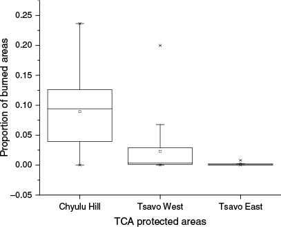
The results showed that the average burned area across the three parks within the TCA was 249.49 km2 (s.d. = 346.79 km2) over the 22-year period. The Chyulu Hill National Park recorded the highest annual mean proportion of burned area at 0.089 (s.d. = 0.059), followed by Tsavo West at 0.023 (s.d. = 0.045), while Tsavo East had the lowest mean proportion at 0.002 (s.d. = 0.002). A one-way ANOVA comparing the mean proportions of burned areas between the three parks, was significantly different (F2,63 = 24.612, P < 0.001). Fig. 2 illustrates the proportion of burned areas in each park within the TCA.
Association between human activities to wildfires in the three parks of the TCA
Out of the 377 questionnaire respondents, 29.44% (n = 111) were women and 70.56% (n = 266) were men. The age group with the largest respondents was 36–45 years, comprising 46.42% (n = 175). In contrast, the age groups 18–25 and 81 and older represented the smallest percentages at 6.9% (n = 26) and 3.98% (n = 15), respectively. The results indicate that only 81 (21.49%) of questionnaire respondents agreed with the statement that natural phenomena cause wildfires in the TCA, while the majority, 296 (78.51%), disagreed. Additionally, a chi-square test assessing the connection of human activities highlighted in the questionnaire to wildfires in the TCA revealed significant association (P < 0.05) in all three parks: Chyulu Hill, Tsavo West and Tsavo East (Table 1). The four activities addressed by the questionnaire were crop farming, pastoralism, carelessness disposal of cigarette ruminants and arson.
Frequency of human activities associated with wildfires in different parks within the TCA
The results showed that poaching is strongly connected to wildfires in Tsavo East and Tsavo West National Parks (100%, n = 5; 100%, n = 11, respectively), whereas Chyulu Hills National Park indicated a relatively lower link (83% n = 5). Honey harvesting is highly connected to wildfires in Chyulu Hills National Park (100% n = 6) and linked lowly in Tsavo East National Park (40%, n = 2). Charcoal burning is also a common activity in Tsavo West National Park (100%, n = 11) but less in the other two regions. Khat harvesting and Cannabis farming were exclusive to Chyulu Hills National Park, suggesting variation in human activities within the TCA. Crop farming was consistent across protected areas. Carelessness in disposing cigarette remnants connected to wildfires was highest in Tsavo East (100%) and lowest linked in Chyulu Hills (50%). Lastly, the burning of elephant dung was minimal, climaxing at 20% in Tsavo East (Fig. 3).

Contribution of human activities to wildfires in Tsavo
The results reveal human activities that contributed to wildfire are directly and indirectly linked. Direct contributors include charcoal burning, poaching, Cannabis farming, pastoralism, wild khat harvesting, careless disposal of cigarette remnants and arson. Indirect contributors are honey harvesting, crop farming, burning of elephant dung and cultural beliefs. For example, smoke from honey harvesting can indirectly cause wildfires, while crop farming practices such as land preparation by burning may accidentally lead to wildfire. Additionally, cultural practices of lighting fire during the dry season to produce smoke that attracts rain may result in unintentional ignitions (Table 2).
| Human activity | Quotes linking the activity to wildfire | |
|---|---|---|
| Charcoal burning | ‘Charcoal burning is illegal in Kenya, occurring during dry seasons and increasing wildfire risks’. | |
| Cannabis sativa farming | ‘Bhang cultivation in remote forests can lead to wildfires from land-clearing fires’. | |
| Wild khat harvesting | ‘Burning wild khat promotes new growth, but can sometimes cause uncontrollable wildfires’. | |
| Arson | ‘Conflicts between rangers and local communities lead to retaliatory forest burning’. | |
| Crop farming | ‘Local farmers use fire to clear land for planting, in the process wooded plants are burnt to produce charcoal’. | |
| Cultural belief | ‘People believe smoke attracts rain, lighting fires during rainy season, causing wildfires’. | |
| Cigarette remnants disposal | ‘Carelessness in dropping of cigarette remnants, mostly along the roads may lead to wildfires’. | |
| Poaching | ‘Poachers use fire to distract rangers, drive animals towards their traps, and promote grass growth’. | |
| Pastoralism | ‘Pastoralists burn forests to promote grass regrowth and manage pests like ticks’. | |
| Honey harvesting | ‘Traditional honey harvesting uses smoke to drive bees out of their hives’. | |
| Burning elephant dung | ‘We burn elephant dung to scare away wild animals’. |
Ranking of human activities contributing to wildfires in different parks
Poaching was highly ranked across all three parks. Charcoal burning activities were the second-ranked practices linked to wildfires. In the Tsavo East and Tsavo West protected areas, charcoal burning was ranked second after poaching, while in the Chyulu Hills National Park, it was ranked third. On the other hand burning of elephant dung to scare away wild animals from homestead areas was not mentioned in Chyulu Hills but was noted in Tsavo East and Tsavo West (Table 3). The Kendall’s W test was used to measure the degree of agreement in ranking human activities linked to wildfires. The findings indicated a high level of consistency in the rankings among the focus group discussions from the three park regions. However, this agreement was not statistically significant (W = 0.8, P = 0.119).
| Activities | Chyulu Hill | Tsavo West | Tsavo East | Mean rank | |
|---|---|---|---|---|---|
| Poaching | 1 | 1 | 1 | 1 | |
| Honey harvesting | 2 | 3 | 6 | 4.5 | |
| Charcoal burning | 3 | 2 | 2 | 2 | |
| Pastoralism | 4 | 5 | 4 | 4.5 | |
| Wild khat harvesting | 5 | – | – | – | |
| Bhang farming | 6 | – | – | – | |
| Arsonist | 7 | 7 | 3 | 5 | |
| Crop farming | 8 | 4 | 8 | 6 | |
| Cultural belief | 9 | 9 | 7 | 8 | |
| Cigarette remnants disposal | 10 | 6 | 5 | 5.5 | |
| Burning elephant dung | – | 8 | 9 | 8.5 |
Discussion
This study has shown that wildfire incidents occur throughout the TCA, but they are unevenly distributed across the area. Chyulu Hills National Park recorded the highest proportion of burned area, followed by Tsavo West and Tsavo East National Parks, respectively. The study attributes variation in the proportion of burned area to differences in the number of human activities linked to wildfires in each protected area. More human activities were linked to wildfires in Chyulu Hills National Park than the other two. These findings are likely due to the heterogeneous nature of the TCA, which includes differences in vegetation cover, rainfall patterns, altitude and population size across its various regions (Kenya Wildlife Service 2008). Additionally, the Chyulu Hill National Park experiences more frequent burns and it has higher number of human activities associated to wildfires probably due to its greater potential for accumulating more fuel load, as it has more vegetation compared to the other two parks (Kiumbuku 2022). Furthermore, the park receives higher rainfall which has earned it the designation of a water tower in Kenya, producing more water than the Taita Hills towers. Its higher altitude likely contributes to the increased rainfall it experiences compared to the other two parks of the TCA (Kiringe et al. 2016). Rainfall increases with elevation in the TCA, and Chyulu Hills National Park, at an altitude of 1810 m, occupies the highest point (Mukeka et al. 2020). Chyulu Hills, which receives more rain, is likely to support thicker vegetation, leading to an increase in fuel loads for wildfires. Moreover, the Chyulu Hills National Park experiences more human activities, probably because its surroundings has a higher human population compared to Tsavo West and Tsavo East (Kenya National Bureau of Statistics 2019).
The study indicated that wildfires across the TCA are predominantly linked to human activities rather than natural causes. The findings also indicate a significant association between human-related activities and wildfires in the TCA. Human activities are directly and indirectly connected to wildfire incidences in the area. These findings align with previous research conducted only in the Chyulu Hills National Park area by Kamau and Medley (2014). The results also match the findings of a study conducted in the Mount Kenya forest that found a significant association between human activities and wildfires (Ndalila et al. 2024). Additionally, this study’s results are consistent with studies such as Chinamatira et al. (2016) in Zimbabwe, which found wildfires predominantly attributed to human activities rather than natural forces. It also corroborates findings by Mgina and Wawa (2020) in Tanzania, highlighting human activities as the primary causes of wildfires in their forest plantations.
These results also identified 11 specific human activities linked to wildfires in the TCA: poaching, honey harvesting, charcoal burning, illegal cultivation of cannabis (Bhang), wild khat harvesting (Catha edulis), arson, crop farming, burning of elephant dung to deter wild animals, cultural beliefs associating smoke with rain attraction, pastoralism, and carelessness in disposal of cigarette remnants. These findings echo similar studies, such as one conducted in Zimbabwe which identified poaching, beekeeping activities, cigarette stub disposal and farm clearing as activities linked to wildfires (Chinamatira et al. 2016). The activities reported in our study also mirror those documented by Kamau and Medley (2014), who linked hunting, charcoal burning, wild khat harvesting, Cannabis cultivation and land clearance to wildfires.
The results also revealed a range of participant opinions across the three regions within the TCA, likely due to the area’s divergent nature. For instance, all key informants from Chyulu Hills National Park (100%, n = 6) linked honey harvesting with wildfire incidences, unlike participants from Tsavo West (70%, n = 8) and Tsavo East (40%, n = 2). This association could be attributed to the increased rainfall received in Chyulu Hills National Park compared to the rest of the TCA (Kiringe et al. 2016). Higher rainfall supports more plant species, which provides food for bees. Additionally, the diversity in opinions can be explained by different ethnic communities in the three regions. The study also showed some unexpected findings; for example, it might have been expected that more informants from the Chyulu Hills National Park region would link crop farming to wildfire incidences than those from the other two regions. However, the activity was strongly connected with wildfires in Tsavo East (100%, n = 5), followed by Tsavo West (90%, n = 10). This could be due to the fact that Chyulu Hills region is wetter, which makes it more difficult to use fire for land clearing compared to the drier areas (Munyao et al. 2020).
This study identified poaching as the most prevalent human activity linked to wildfires in the TCA. The high incidence of hunting is likely due to valuable wildlife species in the TCA, including cheetahs, leopards, African elephants, lions and black rhinos, some of which are endangered (Kiumbuku 2022). The area also supports several endangered herbivores such as hirola (Beatragus hunteri) and Grevy’s zebra (Equus grevyi) (Henschel et al. 2020). The key informants in the field provided insights into how poaching contributes to wildfires. When asked about the connection between poaching and wildfires, one key informant stated:
Poachers burn for different reasons. Some set fires to distract rangers and keep them occupied with firefighting while they engage in hunting. Others use fire to drive wild animals towards their traps, while some burn to stimulate the growth of fresh grass and shoots, attracting small herbivores they target.
These findings align with research conducted in the Siberian Tiger Conservation in Russia, where poaching was identified as the primary human activity linked to wildfires (Conor 2018). Hunting was also highlighted as a significant human activity associated with wildfires (Choga and Nyamadzawo 2018). Similar findings were reported by Nyongesa and Vacik (2019) in their research in the Gathiuru forest of the Mount Kenya region, where fire was noted to be used by poachers for roasting wild animal meat and as a hunting tool.
Other highly ranked activities included honey harvesting and charcoal burning, which were observed to occur across the entire ecosystem. Our study, conducted through key informant interviews, explored how beekeeping contributes to wildfires. When asked about the connection between honey harvesting and wildfires, one respondent explained:
Most people involve themselves in beekeeping, traditionally using fire to smoke out bees during honey harvesting. This practice happens on farms where beekeeping is practiced, or individuals may venture into protected areas to harvest honey from wild bees. Accidentally, the fire used in this process may escape to the surrounding bush, potentially leading to wildfires.
The finding that honey harvesting is connected to wildfires across the entire TCA supports the findings of Ricketts and Shackleton (2020), who noted that honey harvesters accidentally cause wildfires through smoking hives. Similar studies in Tanzania have also indicated that traditional methods involving fire in honey harvesting contribute to wildfire occurrences (Mgina and Wawa 2020; Balele 2021).
The interview method also clarified how charcoal burning is directly linked to wildfires. According to responses from the majority of respondents, ‘Charcoal burning is illegal in Kenya and is mostly conducted at night and deep in the forest where law enforcers cannot reach. During dry periods, charcoal burning becomes more common, enabling the easy spread of fire from charcoal pits to neighbouring vegetation. Traditional kilns, where firewood is placed in a pit dug into the ground and covered with soil, also contribute to wildfires. Often, burning charcoal debris is left carelessly, and when carried by the wind, it can ignite wildfires. These findings are consistent with research conducted in the Gathiuru forest in the Mount Kenya region, where illegal charcoal burning was found to cause significant wildfires (Nyongesa and Vacik 2019). This study also linked farmland preparation to wildfires. A village elder interviewed stated: ‘During land preparation, we use fire to burn grass and shrubs. It’s the easiest way to clear the land, and this practice mostly occurs during the driest months of September and October, making it more likely for the fire to spread to unintended areas such as neighbouring forests. To minimise risks, farmers are advised to notify neighbours before burning to help suppress the fire if it gets out of control, and to avoid burning in the evening when winds are stronger’. The findings align with a study conducted in a Tanzanian forest plantation by Mgina and Wawa (2020), which indicates that fire is used for land clearing after harvesting, a practice common during dry periods. Their research suggests that traditional fire use in farm preparation is linked to insufficient knowledge and poverty. These findings underscore the necessity for educational campaigns among farmers about the risks and drawbacks associated with using fire for land preparation. They also highlight the importance of training farmers in establishing fire breaks to reduce the likelihood of fires spreading to unintended areas.
In Kenya, pastoralism is traditionally practiced in drier regions (Cuni-Sanchez et al. 2019; Mwangi et al. 2020). Conversely, pastoralism was noted as one of the main contributor to wildfires across different regions within the TCA, and it was highly ranked in Tsavo East’s focus discussion. This is expected given that Tsavo East is the driest part of the TCA, making pastoralism the predominant economic activity in this area. Given that a significant portion of the TCA is semi-arid and characterised by grassland and woodland (Mukeka et al. 2020), the area is conducive to pastoralism. During our study, responses gathered from key informant interviews shed light on how pastoralism contributes to wildfires:
Pastoralists burn the forest to encourage regrowth of new and fresh grasses and shoots. They also use fire in pest management, believing it helps control ticks and diseases. Additionally, since herding activities in this region mainly occur during the dry period, pastoralists sometimes move from one place to another, in the process they use fire to scare wild animals and cook.
Our findings align with the literature from Van Zyl et al. (2019), which suggests that pastoralists contribute to wildfires in protected areas. However, our study’s observation that pastoralism contributes to wildfires contrasts with the findings of Colantoni et al. (2020) in Greece, who argue that a decline in nomadic livestock and pastoralism may increase wildfire incidences. Their argument is based on the idea that livestock graze on vegetation, reducing biomass that could otherwise fuel wildfires. These contrasting findings highlight the importance of involving local communities in wildfire management strategies. The study from Greece proposes a strategy where well-managed grazing programs for livestock in protected areas could help reduce wildfire risk by decreasing fuel available for fires. Successful implementation of such a strategy requires collaboration between conservation managers and pastoralists (Van Zyl et al. 2019).
Illegal farming of bhang and wild khat harvesting as contributors to wildfires were only reported in the Chyulu Hills National Park region, likely due to its cooler climate and higher rainfall compared to Tsavo West and Tsavo East (Munyao et al. 2020). These conditions create a favorable environment for the growth of bhang and khat. Bhang farming has been associated with numerous social and ecological challenges, including increased crime, school dropouts and fire outbreaks (Ngoc Thach et al. 2018). Respondents from the Chyulu Hills region, where these activities occur, explained that due to their illegality, bhang cultivation often occurs deep within forests where law enforcement struggles to reach. They reported that fires are used to clear bushland for Bhang cultivation, and sometimes these fires escalate into wildfires. This finding aligns with research from Canada, where indoor bhang cultivation led to electrical system overloads and structural fires (Ngoc Thach et al. 2018). It also supports earlier studies in Chyulu Hills region that highlighted bhang farming and illegal khat harvesting in forests as wildfire risks (Kamau and Medley 2014).
The issue of bhang farming remains contentious globally, including in Kenya where it is illegal (Ndanyi 2021). The high value of bhang has sparked debates on its legalisation in many countries, Kenya included. Proponents argue that regulation through licensing and permits could enhance public safety and environmental protection (Khanal et al. 2021). Concerns about wild khat harvesting in forests as a livelihood activity linked to wildfires in Chyulu Hills National Park were echoed by most interview respondents from that region. They noted that wild khat is burned to promote the growth of fresh shoots, but this process can sometimes lead to serious wildfires when fires are out of control.
Another human activity linked to wildfires in the TCA is arson. Arsonists are individuals who, unable to obtain harvesting licenses, permits, or access permissions to protected areas, resort to burning forests as a form of retaliation (Mgina and Wawa 2020). According to a forest officer from Taita Taveta County interviewed for this study, arsonists have various motivations: some set fires intentionally to exact revenge after conflicts with park rangers or local communities; others do so to pressure management into selling them wood products; and some burn forests as a form of protest against the presence of national parks, perceiving their land as unjustly taken. These findings align with research in Tanzania’s forest plantations, which identified arsonists as significant contributors to wildfires (Mgina and Wawa 2020). The results highlight the need for policy reforms and review to better integrate local communities into the management of protected areas. Management policies should clearly articulate how communities can benefit from these areas, and efforts should be made to educate surrounding communities through workshops and seminars about the short-term and long-term advantages of protected areas.
Conclusion and recommendations
In conclusion, this study has contributed two key findings. First, it highlights that Chyulu Hills National Park, within the Tsavo Conservation Area, is particularly vulnerable to wildfires. The park is notably prone to more frequent burns and has a higher concentration of human activities linked to wildfires. Second, the study found that certain human activities are unique to specific regions. For example, illegal bhang farming and wild khat harvesting were only reported in the Chyulu Hills National Park. This regional variation may be attributed to the diverse nature of the TCA. Additionally, the study confirms that wildfires across national parks in the TCA are closely linked to human activities, with poaching being the most prevalent activity associated with wildfires. The identification of 11 human activities tied to wildfires highlights the urgent need for a reassessment of current wildfire management strategies. Policies should focus on incorporating local communities into the management of protected areas and establishing clear laws, sanctions and penalties for offenses related to wildfires. Furthermore, it is crucial to align wildfire-related policies between national and county governments, given their direct and indirect effects on wildfire risks. Lastly, the study recommends further research on integrated approaches to wildfire management in the TCA.
Data availability
The data used in the analysis and supplementary material for the current study are available online at https://zenodo.org/records/14272385.
Conflicts of interest
The authors declare that they have no known competing financial interests or personal relationships that could have appeared to influence the work reported in this paper.
Declaration of funding
The research field work was funded by the Centre for Biodiversity Information Development (BID-C), Strathmore University, Kenya. The funding was only to facilitate data collection process.
Acknowledgements
We gratefully acknowledge the BID-C, Strathmore University, Kenya for funding this project. We also thank the LEVERHULME Centre for Wildfires, Environment and Society for supporting one of our authors to attend the 2023 Wildfires Summer Conference in London, which significantly contributed to shaping this paper. Special thanks to the Kenya Wildlife Services for granting us the opportunity to conduct our research. We extend our sincere gratitude to Abigael Crocker for her diligent support in data collection in the field.
References
Adam AM (2020) Sample size determination in survey research. Journal of Scientific Research and Reports 26(5), 90-97.
| Crossref | Google Scholar |
Aponte C, De Groot WJ, Wotton BM (2016) Forest fires and climate change: causes, consequences and management options. International Journal of Wildland Fire 25(8), i-ii.
| Crossref | Google Scholar |
Chinamatira L, Mtetwa S, Nyamadzawo G (2016) Causes of wildland fires, associated socio-economic impacts and challenges with policing, in Chakari resettlement area, Kadoma, Zimbabwe. Fire Science Reviews 5(1), 1.
| Crossref | Google Scholar |
Choga D, Nyamadzawo G, 28 (2018) Causes of wildland fires and factors that influence knowledge of fire management at Crofton village, Makoni district, Zimbabwe. Southern Africa Journal of Education, Science and Technology 4(1),.
| Crossref | Google Scholar |
Colantoni A, Egidi G, Quaranta G, D’Alessandro R, Vinci S, Turco R, Salvati L (2020) Sustainable land management, wildfire risk and the role of grazing in Mediterranean Urban-Rural Interfaces: a regional approach from Greece. Land 9(1), 21.
| Crossref | Google Scholar |
Copes-Gerbitz K, Dickson-Hoyle S, Ravensbergen SL, Hagerman SM, Daniels LD, Coutu J (2022) Community engagement with proactive wildfire management in British Columbia, Canada: perceptions, preferences, and barriers to action. Frontiers in Forests and Global Change 5(March), 829125.
| Crossref | Google Scholar |
Croker AR, Ford AES, Kountouris Y, Mistry J, Muthiuru AC, Smith C, Praise E, Chiawo D, Muniu V (2024) Decolonising fire science by reexamining fire management across contested landscapes: a workshop approach. Fire 7(3), 94.
| Crossref | Google Scholar |
Cuni-Sanchez A, Omeny P, Pfeifer M, Olaka L, Mamo MB, Marchant R, Burgess ND (2019) Climate change and pastoralists: perceptions and adaptation in montane Kenya. Climate and Development 11(6), 513-524.
| Crossref | Google Scholar |
Dos Santos SMB, Bento-Gonçalves A, Vieira A (2021) Research on wildfires and remote sensing in the last three decades: a bibliometric analysis. Forests 12(5), 604.
| Crossref | Google Scholar |
Giglio L, Randerson JT, van der Werf GR, Kasibhatla PS, Collatz GJ, Morton DC, DeFries RS (2010) Assessing variability and long-term trends in burned area by merging multiple satellite fire products. Biogeosciences 7(3), 1171-1186.
| Crossref | Google Scholar |
He T, Lamont BB, Pausas JG (2019) Fire as a key driver of Earth’s biodiversity. Biological Reviews of the Cambridge Philosophical Society 94(6), 1983-2010.
| Crossref | Google Scholar | PubMed |
Henry MC, Maingi JK, McCarty J (2019) Fire on the water towers: mapping burn scars on mount Kenya using satellite data to reconstruct recent fire history. Remote Sensing 11(2), 104.
| Crossref | Google Scholar |
Henschel P, Petracca LS, Ferreira SM, Ekwanga S, Ryan SD, Frank LG (2020) Census and distribution of large carnivores in the Tsavo national parks, a critical east African wildlife corridor. African Journal of Ecology 58(3), 383-398.
| Crossref | Google Scholar |
Jain M, Saxena P, Sharma S, Sonwani S (2021) Investigation of forest fire activity changes over the Central India domain using satellite observations during 2001–2020. GeoHealth 5(12), e2021GH000528.
| Crossref | Google Scholar |
Jhariya MK, Raj A (2014) Effects of wildfires on flora, fauna and physico-chemical properties of soil - An overview. Journal of Applied and Natural Science 6(2), 887-897.
| Crossref | Google Scholar |
Kamau PN, Medley KE (2014) Anthropogenic fires and local livelihoods at Chyulu Hills, Kenya. Landscape and Urban Planning 124, 76-84.
| Crossref | Google Scholar |
Kenya National Bureau of Statistics (2019). Kenya population and housing census volume 1: Population by County and sub-County. In ‘Kenya National Bureau of Statistics: Vol. I (Issue November)’. Available at https://www.knbs.or.ke/?wpdmpro=2019-kenya-population-and-housing-census-volume-i-population-by-county-and-sub-county
Khanal S, Khanal S, Christian S (2021) Cannabis legalization and potential impacts on Nepali economy and public health. Global Journal of Agricultural and Allied Sciences 3(1), 25-28.
| Crossref | Google Scholar |
Kiringe JW, Mwaura F, Warinwa F (2016) Characterization of Chyulu Hills Watershed Ecosystem Services in South-Eastern Kenya. Environment and Natural Resources Research 6(3), 65.
| Crossref | Google Scholar |
Kiumbuku SK (2022) Challenges of community-based management of protected areas: contested trade-offs between livelihood and conservation interests in Chyulu Hills National Park, Kenya. Environment and Natural Resources Research 12(2), 1.
| Crossref | Google Scholar |
Koskei M, Kolowski J, Wittemyer G, Lala F, Douglas-Hamilton I, Okita-Ouma B (2022) The role of environmental, structural and anthropogenic variables on underpass use by African savanna elephants (Loxodonta africana) in the Tsavo Conservation Area. Global Ecology and Conservation 38(June), e02199.
| Crossref | Google Scholar |
Kouassi JLK, Wandan NE, Mbow C (2018) Assessing the impact of climate variability on wildfires in the n’zi river watershed in central Côte D’Ivoire. Fire 1(3), 36.
| Crossref | Google Scholar |
Krah CY, Perdinan Perdinan, Njume AC, Aminah (2020) Refocusing on community-based fire management (A Review). IOP Conference Series: Earth and Environmental Science 504(1),.
| Crossref | Google Scholar |
Lala F, Chiyo PI, Kanga E, Omondi P, Ngene S, Severud WJ, Morris AW, Bump J (2021) Wildlife roadkill in the Tsavo Ecosystem, Kenya: identifying hotspots, potential drivers, and affected species. Heliyon 7(3), e06364.
| Crossref | Google Scholar | PubMed |
McLauchlan KK, Higuera PE, Miesel J, Rogers BM, Schweitzer J, Shuman JK, Tepley AJ, Morgan Varner J, Veblen TT, Adalsteinsson SA, Balch JK, Baker P, Batllori E, Bigio E, Brando P, Cattau M, Chipman ML, Coen J, Crandall R, Kendra McLauchlan CK (2020) Fire as a fundamental ecological process: research advances and frontiers. Wiley Online Library 108(5), 2047-2069.
| Crossref | Google Scholar |
Mgina M, Wawa A (2020) Assessment of wildfires in Tanzania forest plantations: a case of Sao Hill in Mufindi District. Huria Journal 27(2), 30-55.
| Google Scholar |
Mistry J, Bilbao BA, Berardi A (2016) Community owned solutions for fire management in tropical ecosystems: case studies from Indigenous communities of South America. Philosophical Transactions of the Royal Society B: Biological Sciences 371(1696), 20150174.
| Crossref | Google Scholar |
Mukeka JM, Ogutu JO, Kanga E, Røskaft E (2020) Spatial and temporal dynamics of human–wildlife conflicts in the Kenya Greater Tsavo Ecosystem. Human-Wildlife Interactions 14(2), 255-272.
| Google Scholar |
Munyao M, Siljander M, Johansson T, Makokha G, Pellikka P (2020) Assessment of human–elephant conflicts in multifunctional landscapes of Taita Taveta County, Kenya. Global Ecology and Conservation 24, e01382.
| Crossref | Google Scholar |
Muriuki G, Seabrook L, McAlpine C, Jacobson C, Price B, Baxter G (2011) Land cover change under unplanned human settlements: a study of the Chyulu Hills squatters, Kenya. Landscape and Urban Planning 99(2), 154-165.
| Crossref | Google Scholar |
Mwangi V, Owuor S, Kiteme B, Giger M (2020) Beef production in the rangelands: a comparative assessment between pastoralism and large-scale ranching in Laikipia county, Kenya. Agriculture 10(9), 399.
| Crossref | Google Scholar |
Ndalila MN, Lala F, Makindi SM (2024) Community perceptions on wildfires in Mount Kenya forest: implications for fire preparedness and community wildfire management. Fire Ecology 20, 92.
| Crossref | Google Scholar |
Ndanyi S (2021) Cannabis in Kenya. Southern Journal for Contemporary History 46(2), 4-23.
| Crossref | Google Scholar |
Ngoc Thach N, Bao-Toan Ngo D, Xuan-Canh P, Hong-Thi N, Hang Thi B, Nhat-Duc H, Dieu TB (2018) Spatial pattern assessment of tropical forest fire danger at Thuan Chau area (Vietnam) using GIS-based advanced machine learning algorithms: a comparative study. Ecological Informatics 46, 74-85.
| Crossref | Google Scholar |
Nyambariga FK, Opere AO, Kituyi E, Amwata DA (2023) Climate change scenario projections and their implications on food systems in Taita Taveta County, Kenya. PLoS Climate 2(6), e0000114.
| Crossref | Google Scholar |
Nyongesa KW, Vacik H (2019) Evaluating management strategies for Mount Kenya Forest Reserve and National Park to reduce fire danger and address interests of various stakeholders. Forests 10(5), 426.
| Crossref | Google Scholar |
Nyumba T, Wilson K, Derrick CJ, Mukherjee N (2018) The use of focus group discussion methodology: insights from two decades of application in conservation. Methods in Ecology and Evolution 9(1), 20-32.
| Crossref | Google Scholar |
Pausas JG, Keeley JE (2019) Wildfires as an ecosystem service. Frontiers in Ecology and the Environment 17(5), 289-295.
| Crossref | Google Scholar |
Rashidi P (2018) Elephant poaching in space and time. ITC Dissertation (Issue 328). 10.3990/1.9789036546157
Ricketts K, Shackleton CM (2020) Integrating livelihoods and forest conservation through beekeeping in northern KwaZulu-Natal. Development Southern Africa 37(4), 661-677.
| Crossref | Google Scholar |
Tedim F, Leone V, Amraoui M, Bouillon C, Coughlan MR, Delogu GM, Fernandes PM, Ferreira C, McCaffrey S, McGee TK, Parente J, Paton D, Pereira MG, Ribeiro LM, Viegas DX, Xanthopoulos G (2018) Defining extreme wildfire events: difficulties, challenges, and impacts. Fire 1(1), 9.
| Crossref | Google Scholar |
Tymstra C, Stocks BJ, Cai X, Flannigan MD (2020) Wildfire management in Canada: review, challenges and opportunities. Progress in Disaster Science 5, 100045.
| Crossref | Google Scholar |
Van Zyl H, Kinghorn J, Emerton L (2019) National park entrance fees: a global benchmarking focused on affordability. Parks 25(1), 39-54.
| Crossref | Google Scholar |
Ward M, Tulloch AIT, Radford JQ, Williams BA, Reside AE, Macdonald SL, Mayfield HJ, Maron M, Possingham HP, Vine SJ, O’Connor JL, Massingham EJ, Greenville AC, Woinarski JCZ, Garnett ST, Lintermans M, Scheele BC, Carwardine J, Nimmo DG, et al. (2020) Impact of 2019–2020 mega-fires on Australian fauna habitat. Nature Ecology & Evolution 4(10), 1321-1326.
| Crossref | Google Scholar |