

Learning from Wildfire Decision Support: large language model analysis of barriers to fire spread in a census of large wildfires in the United States (2011–2023)
Margaret D. Epstein A * and Carl A. Seielstad AA
Abstract
Barriers are the landscape features that firefighters leverage to stop wildfire spread. In the United States, decision-makers discuss barrier availability in a framework called the Wildland Fire Decision Support System (WFDSS).
This study analyzes WFDSS text from 6630 large wildfires and examines the barriers identified.
A large language model was trained and validated, then used to detect 13 different barriers. Burn scar and fuel treatment barriers were compared with their availability near each fire.
Decision-makers recognize barriers on most wildfires (75%) and explicitly state when they are not present. Roads (42% of incidents), burn scars (26%) and natural fuel variability (25%) are the most common barriers. There is a strong relationship between the amount of burned area and the probability that it is identified as a barrier. The relationship between fuel treatment barriers and their availability is weak, but fuel treatments are recognized as barriers at lower landscape thresholds than burn scars.
Prior wildfire yields more opportunities for stopping fire spread than fuel treatments. However, a smaller area must be treated than burned naturally before fire managers consider it a barrier.
This study helps direct policy towards expanding useful barriers.
Keywords: barriers to fire spread, beneficial fire, burnt area, emergency response, fire use, fuel treatment, organizational learning, prescribed fire, United States, wildfire.
Introduction
Fire response in the United States is becoming increasingly complex. Recent fuel accumulation (Hagmann et al. 2021) and increasingly extreme climatic conditions (Abatzoglou et al. 2019; Parks and Abatzoglou 2020; Higuera and Abatzoglou 2021) are yielding more extreme fire behavior, while the expansion of communities into naturally flammable landscapes (Radeloff et al. 2018) places more values in harm’s way. However, even as wildfire is becoming more destructive to communities (Higuera et al. 2023), there is a growing understanding of the natural role of fire as a shaper of terrestrial life (Pausas and Keeley 2009), and the ecological consequences of fire suppression in systems that depend on it (Steel et al. 2015; Cochrane and Bowman 2021; Hagmann et al. 2021). As the fire environment becomes more complex, identifying and creating barriers that enable fires to burn while preventing them from reaching human values has become crucial for de-escalating risk. Thus, much analysis of wildfires in the US is focused on predicting whether a fire in the hinterland is likely to reach front country values (Noonan-Wright and Seielstad 2021) and whether the presence or absence of barriers might slow a fire’s progression or provide firefighters a chance to stop it.
In the United States, the calculus of risk assessment during wildfires, including barrier availability, is documented in a system called the Wildland Fire Decision Support System (WFDSS) (Noonan-Wright et al. 2011). The WFDSS is a compilation of geospatial data, fire behavior modeling and writing prompts that are designed to facilitate systematic decision making on wildfires. The WFDSS is mandated by federal policy and has been in use since 2011 (Noonan-Wright et al. 2011). Formal WFDSS decisions are required when incidents escape initial attack, include resource benefit objectives, or require escalation to higher levels of authority (Noonan-Wright et al. 2011).
The WFDSS prompts decision-makers to rationalize many facets of the fire situation and response, including the presence or absence of barriers available to impede fire spread. Fire managers sometimes identify previous wildfires, prescribed fires and mechanical fuel treatments as barriers. These barriers are currently of major interest to American policy-makers who have invested billions of dollars in fuel treatments to reduce wildfire risk (US Forest Service 2022; US Department of Interior 2024). There is a growing body of research indicating that treatments can curb fire spread (Finney 2001; Finney et al. 2007), moderate fire behavior and favorably alter subsequent fire effects (Prichard and Kennedy 2014; Kalies and Yocom Kent 2016; Jones et al. 2025). There are also anecdotal instances where fuel treatments improved firefighter safety and strategic opportunities on individual wildfires (Moghaddas and Craggs 2007; Greiner et al. 2025), but these ideas lack systematic evidence (Kalies and Yocom Kent 2016). Given the odds of a treatment in the US ever encountering a wildfire in its lifespan is low (<7% in one study; Barnett et al. 2016), treatment effectiveness research is, by necessity, largely limited to simulation modeling (Seto et al. 2022; Ott et al. 2023) on the rare units that encounter wildfire (McKinney et al. 2022). Little is known about the utility of fuel treatments as barriers relative to other, naturally available barriers such as burn scars.
Although fuel treatment ‘usefulness’ is a multifaceted question, this study seeks to address one aspect by evaluating the rate at which fire managers identify fuel treatments as barriers to fire spread relative to other landscape barriers. We utilized the OpenAI model ‘gpt-4’ via an application programming interface (API) in RStudio to evaluate the barriers discussed by decision-makers on wildfires. First, we quantify the rate at which 13 different barriers are discussed, ranging from natural features such as rivers and burn scars to managed landscape modifications such as prescribed fire. Next, we validate model outputs against the interpretation of experienced firefighters. Last, we evaluate the rate at which fuel treatments and burn scars are discussed relative to their landscape prevalence on federal lands. This analysis is limited to federal lands because consistent fuel treatment documentation is available on federal lands, whereas data availability is mixed elsewhere. Burn scars are also included in the spatial analysis because they are naturally available, modify and reduce fuels similarly to prescribed fire treatments, and are common features on the landscape. Thus, they provide a natural quasi-control group for evaluating fuel treatments as barriers relative to landscape prevalence.
The objectives of our work are:
To apply a large language model (LLM) to identify the barriers to fire spread recognized by fire managers in the text of all formal decisions documented in the WFDSS from 2011 to 2023, and to validate model outputs against human interpretation.
To quantify, compare and map the rate of occurrence of 13 different barriers discussed in the formal decisions of wildfires.
To assess the prevalence of burn scars and fuel treatments that are of utility in managing an incident relative to their actual presence on the landscape.
This work is novel in its use of an LLM to synthesize aspects of fire decision-making previously hidden in unwieldy text databases, and because it considers a census of complex American fires, thus enabling systematic analysis of factors affecting decision-making. It includes 24,254 unique entries from 6630 incidents, ranging from a few sentences to pages of text per entry. Because of the sheer amount of text stored, past studies analyzing the contents of the WFDSS have been limited to samples manageable for human readers (Noonan-Wright and Seielstad 2024) or the most coarse, non-narrative information available for each fire (Noonan-Wright and Seielstad 2021). Although text mining techniques for parsing large datasets have long existed (Rajman and Besançon 1998), they historically have relied on case-matching specific phrases and are poor at evaluating language in context. However, within the last 2 years, commercially available large language models such as the ChatGPT series have offered more flexible tools better suited for linguistic nuance. These models are ‘statistical correlation machines’ (Zhou et al. 2024), in which probabilistic best answers are selected relative to a neural network defining relationships between words. The underlying neural networks are trained on huge sets of text gleaned from the internet. However, because the training set is nebulous and likely biased, models are prone to the generation of incorrect information that sounds plausible (Huang et al. 2025). Thus, there are profound limitations to these models in fields that require human judgement (Azamfirei et al. 2023), and their ethical use with respect to their limitations must be seriously considered (Zhou et al. 2024). However, when given constrained problems and supervised by human researchers, LLMs have solved difficult problems in chemistry and biomedicine (Kim et al. 2021; Rives et al. 2021; Luo et al. 2022; Boiko et al. 2023). This study seeks to apply a similar LLM to a problem in fire science.
Methods
Notes on terminology, editorialization of WFDSS entries and data availability
Fire is a natural and morally neutral landscape process, and the phrase ‘burn scar’ can have negative connotation because it implies fire history is a wound on the landscape. Although ‘burned areas’ is also commonly used, this paper continues to use the phrase ‘burn scar’ to describe areas recently touched by fire because it is the vocabulary our study subjects generally use when writing in the WFDSS.
This study also uses ‘fire managers’ interchangeably with ‘authors’ to describe the writers of the WFDSS entries we study. Decisions on large wildfires are shared amongst many, ranging from professional firefighters to administrators of land management agencies. ‘Fire manager’ is not anyone’s job title on an incident, but we use it to describe the conglomerate of people responsible for the choices documented in the WFDSS.
The full WFDSS text is not yet publicly available owing to the sensitive nature of emergency response decision-making, although the federal agencies responsible for the WFDSS intend to provide a reporting interface in the future. In the meantime, data on barriers aggregated to dispatch zones are shared in Supplementary File S1 and multiple excerpts of text from the WFDSS are also shared in this paper. Fires are identified by geographic region and year of ignition. All mentions of a fire’s name or identifying geographic information have been removed. These edits are denoted in square brackets. We corrected spelling and replaced acronyms with their long form but otherwise show the unedited writings of WFDSS authors.
Text cleaning
The WFDSS is organized into several sections, each designed to facilitate structured decision-making in a particular facet of emergency response. This study utilized the Relative Risk Assessment (RRA) and Organizational Assessment (OA) portions of the WFDSS. These portions are designed to help fire managers define incident risk and evaluate the resources needed.
The RRA and OA each have three sections with three subsections (Table 1). In these frameworks, decision-makers assign an ordinal level of complexity (high, medium, or low) to each subsection and write text explaining their decision for each category. Fire managers are explicitly prompted to discuss barriers in the ‘Barriers to fire spread’ subsection of the RRA (Table 1), but barriers often inform other sections as well, so all text from the RRA and OA was included in analysis.
| Relative Risk Assessment | Organizational Assessment | |||
|---|---|---|---|---|
| Sections | Subsections | Sections | Subsections | |
| Values | Natural, cultural resources and infrastructure | (From relative risk assessment) | Values | |
| Proximity and threat of fire to values | Hazards | |||
| Social/economic concerns | Probability | |||
| Hazards | Fire behavior | Implementation difficulty | Incident strategy | |
| Fuel condition | Potential fire duration | |||
| Potential fire growth | Functional concerns | |||
| Probability | Barriers to fire spread | Socio-political concerns | External influences | |
| Time of season | Objective concerns | |||
| Season severity | Ownership concerns | |||
The WFDSS is updated as fire conditions change, and the OA and RRA can be updated independently of each other. Thus, most long-duration wildfires have multiple WFDSS entries. Text is often duplicative, where writers copy and paste from section to section, or as they update the WFDSS. The R packages quanteda (Benoit et al. 2018) and stringr (Wickham 2023) were used to aggregate the OA and RRA, then identify the unique text for each fire each day. Entries with no text on a given day were not considered. Ultimately, a set of 24,254 entries from 6630 unique fires were considered.
Typical WFDSS entries, once cleaned of duplicative text and aggregated into a single paragraph look like the examples below.
Fire being monitored by [lookout]. No additional staffing needed. Fire located within and adjacent to recent large stand-replacing fire scars. Natural barriers including rock & fire scars. Energy Release Component = 90%, 1000-h fuels < 15%. Interior wilderness. Infrastructure not threatened. Smoke may impact river corridor, commercial river users. Lookout monitoring fire behavior. Additional resources unnecessary. Recent fire has significantly reduced the risk of crown fire & rapid rate of spread.
– 2013, Great Basin Region
This fire is well within Forest Service boundary. The objectives are straightforward. External influences are the highest concern of this category due to the potential visibility of this fire, with potential impacts to recreation. This high elevation fire is in spruce and fir with rocks above the fire. The fire has received precipitation lately and is exhibiting minimal fire behavior in the way of smoldering. With the rock slab above, potential fire growth is minimal. This fire started on the 9th of October. Since ignition, the fire area has received precipitation. With the scree slopes/timberline above the fire, movement is expected to be minimal. This has been a long mostly dry fire season and it’s possible this precipitation has not affected the fire area as much as we think… We have made the decision to not engage firefighters in the area due to the unpredictable weather of the season, remoteness, lack of available resources, and low values at risk.
– 2016, Rocky Mountain Region
Modeling
The commercially available OpenAI model ‘gpt-4’ (OpenAI et al. 2023) was used for text mining. It was accessed via RStudio from an API. The code used to access the model and prompt the return of barriers from text is available in Supplementary File S2.
Model development differed from traditional machine learning because the model structure was not directly manipulated by researchers. Rather, a set of written prompts were manually adjusted in a systematic, iterative process. A training set of 20 WFDSS entries were used for model development. The training set was relatively small compared with traditional machine learning methods because there are no quantitative performance metrics to evaluate if the model is correctly identifying barriers from text. So a human developer had to read each entry against the model outputs and attempt to identify language in the instructions that was yielding incorrect or nonsensical results. To aid this process, the model was initially asked to provide results in a text string. For example, it would return ‘rocks, scree slopes and timberline’ when asked about the barriers discussed for the 2016 Rocky Mountain Region fire in the above excerpt. Then, the human developer cross-referenced the output text string with the input text to identify the specific phrases in context that the model was identifying as barriers. For example, early iterations erroneously returned ‘firefighters’ and ‘helicopters’ as barriers to fire spread. The instructions were tweaked to specify that barriers are ‘physical landscape features’ (Supplementary File S2). Additionally, the instructions were modified to explicitly state that barriers must stop fire spread and not make it worse. This was included to provide clarity to both the model and human validators, and to avoid false positive barrier identification in cases where logging slash or incomplete fuel treatments were worsening fire behavior. Last, the instructions specified that conditional barriers still count as barriers to reduce ambiguity for both human and machine interpretation. For example, if a fire manager writes ‘roads currently limiting fire spread but will likely fail if long-range spotting increases’, roads are still considered a barrier. The full set of instructions provided to the model and human validators is shared in Supplementary File S2.
When the model was consistently producing correct results (defined as consistent with the human developer’s interpretation of the barriers in the entry), a categorical system was introduced. This was created so model outputs would be quantifiable and comparable across time and geography. The model was provided with 13 categories and asked to denote a binary presence or absence for each category for each WFDSS entry.
These categories were chosen to encompass the common barriers referenced in the WFDSS. The model, and later human validators, could choose multiple barriers from the first 10 rows (Table 2) if multiple barriers were referenced in text. When selecting no barriers, vague barriers, or none mentioned, only one option was allowed. The model was then tested for reproducibility of results. A single paragraph was provided to the model 20 times to evaluate if it would provide the same categorical outcomes for each iteration, which it did successfully.
| Barrier name | Descriptive text provided to large language model and human validators | |
|---|---|---|
| Burn scars | Fire in years prior, burn scars | |
| Mechanical treatment | Fuel treatment or fuel mitigation | |
| Prescribed fire | Prescribed fire | |
| Commercial timber | Timber sales, logging, clearcutting | |
| Fireline | Fireline, hand line, dozer line, constructed line features | |
| Roads | Roads and trails | |
| Rivers | Rivers and riparian areas | |
| Natural features | Natural features such as rock outcroppings and scree fields | |
| Sparse fuel | Non-receptive fuels, high elevation fuels, sparse fuels | |
| Agriculture | Agriculture | |
| No barriers | No barriers, few barriers, or inadequate barriers | |
| Vague barriers | Vague barriers, statements such as natural and man-made barriers without further specification | |
| None mentioned | Barriers are not mentioned in text |
Validation
A total of 260 WFDSS entries were selected randomly for validation. Each entry in the validation set was read by two experienced current or former wildland firefighters from a pool of 12 individuals. Readers were primarily United States federal and Montana state fire resources personnel. Qualifications included Incident Commanders (Type 5 to Type 3), smokejumpers, rappelers, a helicopter pilot, and various members of Complex Incident Management Teams with positions in operations and planning. Human readers were given the same set of instructions provided to the LLM (Table 2, Supplementary File S2) and asked to denote the presence or absence of each of the 13 categorical barriers in each entry. Simple agreement and Cohen’s kappa (McHugh 2012) were calculated between the two human readers and the model on a category-by-category basis for each of the 13 barriers. Model error was defined as cases where the two humans chose one binary outcome, and the model chose the other. Human error was defined as cases where one human and the model agreed on barrier presence or absence, and the other human reader chose the other outcome.
Rate calculation and aggregation to Geographic Area Coordination Centers (GACCs) and dispatch zones
After validation, the model predicted the presence or absence of the 13 barriers on all entries in the WFDSS (N = 24,254). Then, results were aggregated to each fire. Barriers were considered present if they appeared in any WFDSS entry belonging to a particular fire. First, the rate at which each barrier was discussed in the WFDSS was calculated for each Geographic Area Coordination Center (GACC) in the nation, then each dispatch zone in the nation. The US has 10 GACCs, which serve both as geographic delineations and as interagency governance systems for fire intelligence and resource allocation. Dispatch zones, nested within GACCs, function similarly on a smaller scale. Although typically interagency, some dispatch zones correspond to a single landowner, such as a national park. Firefighting resources within a dispatch zone train together, follow shared procedures, and often respond jointly to incidents.
GACCs and dispatch zones were chosen as the primary unit of analysis because they are the operational units that wildfire management is organized around in the United States. GACCs have been studied previously in regard to patterns in the WFDSS (Noonan-Wright and Seielstad 2022, 2024), and this study builds on that work. Simple jurisdictional boundaries are too reductive for evaluating large wildfires that often cross administrative boundaries, and GACCs and dispatch zones are generally interagency. Dispatch zones are also small enough to have variability in ecosystems and fuel types between them, while still being administrative boundaries in a study focused on operational fire.
Relative use of burn scars and fuel treatments on federal land
The second part of this study focuses on the discussion of burn scars and fuel treatments as barriers relative to their landscape availability. The latter analysis is constrained to federal lands owing to the mixed documentation of fuel treatments completed by other jurisdictions. Prescribed fire and mechanical treatment were aggregated into a single category ‘fuel treatment’ for this portion of analysis because they often co-occurred on the same sites.
Burn scar locations were determined using the Monitoring Trends in Burn Severity (MTBS) dataset (Eidenshink et al. 2007), which includes incidents dating back to 1985. Only wildfires were included in the analysis. Fuel treatment locations were determined with the Interagency Fuel Treatment Decision Support System (IFTDSS) (US Department of the Interior and US Department of Agriculture 2024). It documents fuel treatments of all prescriptions dating back to the early 1900s, though the vast majority were completed post-1999. The IFTDSS was filtered to only include completed fuel treatments and to exclude wildland fire use as a treatment. Units that do not specify a prescription (e.g. prescribed fire, pile burning) were also removed.
WFDSS incidents were filtered to exclude fires with no federal land or cooperators. Concentric rings of buffers (1, 5, 10, 20 and 50 km) were created around each incident's ignition point, then spatially intersected with MTBS fire perimeters and IFTDSS fuel treatments that occurred before the incident. This spatial intersection yields, for each incident: (1) the proportion of area burned around the incident at the time of the incident, evaluated as 1, 5, 10, 20, and 50 km neighborhoods; (2) the proportion of area treated around each incident at the time of incident within the same neighborhoods. Then, a binomial model was used to evaluate: (1) the probability of a burn scar identified by a decision-maker as a function of the proportion of surrounding area burned; and (2) the probability of a fuel treatment identified by a decision-maker as a function of the proportion of the surrounding area treated, for each of the five neighborhoods around each incident.
Results
Validation
Human readers and the model reached consensus on an interpretation of the text in 84.6% of cases. Overall human–model agreement was slightly better than human–human agreement (Cohen’s kappa of 0.78 versus 0.64), though both were substantial or better across 22 of 30 categories and fair or less in three categories (Table 3). Human readers and the model were both more prone to errors of commission than omission (Table 3). Both consistently identified agriculture, burn scars, natural barriers, rivers, none present and none mentioned (kappa = 0.62–0.88). Humans achieved fair to no agreement in only three categories: fireline, mechanical treatment and vague. Human–model agreement was lowest for roads (kappa = 0.57). Few mechanical treatments appeared in the validation set (N = 10) and human–human agreement was inconsistent for these observations (kappa = 0.16).
| Statistic | Agriculture | Burn scars | Fireline | Mechanical | Natural | None | None mentioned | Rivers | Roads | Prescribed Fire | Sparse fuels | Timber | Vague | Total | ||
|---|---|---|---|---|---|---|---|---|---|---|---|---|---|---|---|---|
| Simple Agreement | Agree (barrier absent in text) | 254 | 180 | 204 | 250 | 162 | 171 | 188 | 200 | 157 | 217 | 183 | 244 | 198 | 2608 | |
| Agree (barrier present in text) | 3 | 40 | 7 | 1 | 51 | 25 | 15 | 25 | 43 | 14 | 16 | 2 | 8 | 250 | ||
| Human false negative A | 1 | 20 | 12 | 4 | 11 | 24 | 2 | 8 | 10 | 8 | 6 | 5 | 10 | 121 | ||
| Human false positive | 0 | 5 | 25 | 5 | 15 | 6 | 28 | 8 | 1 | 13 | 31 | 2 | 28 | 167 | ||
| Model false negative B | 0 | 0 | 2 | 0 | 9 | 8 | 26 | 3 | 0 | 3 | 19 | 1 | 4 | 75 | ||
| Model false positive | 2 | 15 | 10 | 0 | 12 | 26 | 1 | 16 | 49 | 5 | 5 | 6 | 12 | 159 | ||
| Interrater reliability (kappa) C | Human–model | 0.80 | 0.86 | 0.85 | 1.00 | 0.82 | 0.67 | 0.71 | 0.77 | 0.57 | 0.88 | 0.75 | 0.70 | 0.81 | 0.77 | |
| Human–human | 0.86 | 0.70 | 0.25 | 0.16 | 0.75 | 0.62 | 0.66 | 0.74 | 0.86 | 0.57 | 0.56 | 0.45 | 0.30 | 0.64 |
Census results
Incidents occurred in all GACCs, though were concentrated in the western United States. Most WFDSS entries (75%) discussed barriers, and did so in specific, non-vague terms (Table 4). In 21% of incidents, managers explicitly discussed a lack of barriers at some point in the lifecycle of the incident. Landscapes without barriers were most common in Alaska, though present nationally. However, barrier availability is more variable within GACCs than between them (Supplementary File S1), and most Western regions have one to two dispatch zones where barriers were at some point unavailable in ~40% of incidents. Of the 1421 fires where managers stated that no barriers were present, 46% had a barrier at a different time in the fire, representing a mix of incidents that burned through their barriers, had fireline constructed over the course of the incident, or grew to a size at which they encountered barriers not immediately nearby at their inception.
| Linear features | Natural landscape variability | Human landscape modification | No barriers | ||||||||||||
|---|---|---|---|---|---|---|---|---|---|---|---|---|---|---|---|
| Geographic area | N | Fireline | Rivers | Roads | Burn scars | Natural | Sparse fuel | Agriculture | Mechanical treatment | Prescribed fire | Timber | Vague | None mentioned | None present | |
| Overall | 6630 | 0.15 | 0.16 | 0.42 | 0.26 | 0.25 | 0.10 | 0.02 | 0.02 | 0.09 | 0.04 | 0.13 | 0.12 | 0.21 | |
| Alaska | 565 | 0.07 | 0.52 | 0.21 | 0.28 | 0.10 | 0.08 | 0.01 | 0.00 | 0.02 | 0.01 | 0.10 | 0.09 | 0.29 | |
| Eastern | 109 | 0.23 | 0.28 | 0.44 | 0.10 | 0.10 | 0.03 | 0.01 | 0.04 | 0.05 | 0.04 | 0.15 | 0.23 | 0.17 | |
| Great Basin | 1096 | 0.10 | 0.11 | 0.34 | 0.27 | 0.31 | 0.17 | 0.04 | 0.01 | 0.09 | 0.02 | 0.14 | 0.13 | 0.18 | |
| Northern California | 334 | 0.27 | 0.22 | 0.53 | 0.29 | 0.24 | 0.08 | 0.01 | 0.01 | 0.08 | 0.04 | 0.13 | 0.15 | 0.17 | |
| Northern Rockies | 1043 | 0.12 | 0.11 | 0.31 | 0.34 | 0.25 | 0.08 | 0.01 | 0.01 | 0.06 | 0.06 | 0.10 | 0.13 | 0.22 | |
| Northwest | 1020 | 0.17 | 0.16 | 0.47 | 0.18 | 0.25 | 0.08 | 0.05 | 0.01 | 0.10 | 0.06 | 0.12 | 0.12 | 0.25 | |
| Rocky Mountain | 649 | 0.14 | 0.11 | 0.43 | 0.16 | 0.31 | 0.14 | 0.03 | 0.02 | 0.10 | 0.04 | 0.18 | 0.08 | 0.25 | |
| Southern | 369 | 0.31 | 0.14 | 0.56 | 0.14 | 0.14 | 0.04 | 0.01 | 0.09 | 0.11 | 0.04 | 0.18 | 0.10 | 0.22 | |
| Southern California | 423 | 0.22 | 0.18 | 0.43 | 0.34 | 0.32 | 0.08 | 0.00 | 0.01 | 0.06 | 0.00 | 0.10 | 0.15 | 0.19 | |
| Southwest | 1022 | 0.15 | 0.10 | 0.55 | 0.32 | 0.24 | 0.09 | 0.01 | 0.06 | 0.13 | 0.04 | 0.14 | 0.09 | 0.16 | |
Roads were the most common barrier identified by fire managers nationally. Burn scars were the most common in much of the Northern Rocky Mountains, central Sierra Nevada Mountains and central Alaska (Fig. 1). Natural features such as cliff faces, scree fields and avalanche chutes were also common (Table 4), particularly in the western United States (Fig. 1). Landscape modifications such as agriculture, mechanical treatment, prescribed fire and timber harvest were rarely discussed in the WFDSS. Prescribed fire was the most common modification, though timber harvest was locally important in the Dakotas, Pacific Northwest, Alaska and isolated dispatch zones throughout the eastern area (Fig. 1). Mechanical fuel treatments were universally rare at GACC scale, though isolated dispatch zones nationwide utilize mechanical treatment at a higher rate (Supplementary File S1), and mechanical treatment is the most common landscape modification in a cluster of Southern and Midwestern Dispatch zones (Fig. 1). Prescribed fire is the most common barrier from pre-wildfire land management through most of the nation (Fig. 1).
The most common barrier identified in each dispatch zone (top); and the most common barrier constructed through human landscape modification (bottom).
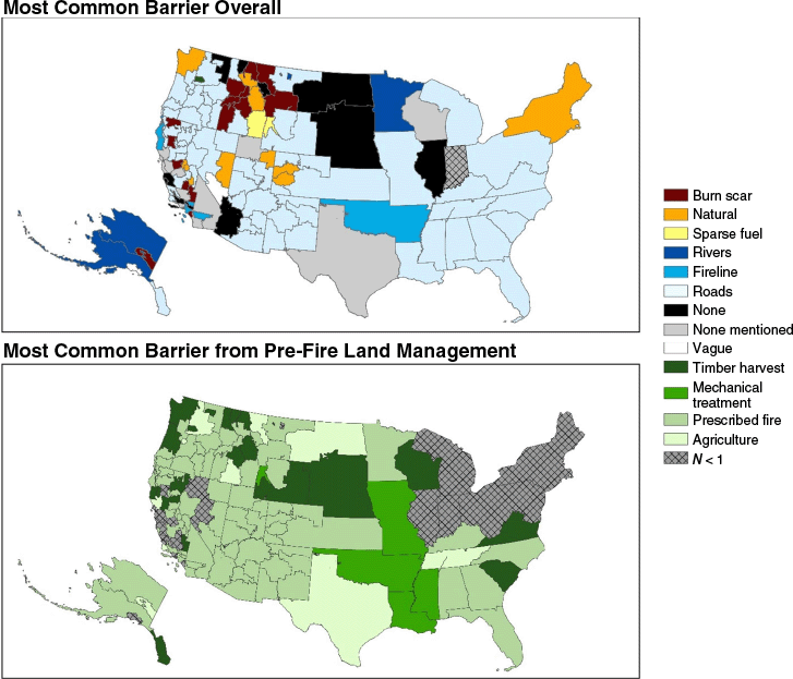
Although individual dispatch zones generally mirror the patterns of the GACC in which they are nested, there are several outliers where local barrier discussions deviate from regional and national rates (Supplementary File S1). For example, on the Tongass National Forest, 33% of incidents utilized commercial timber harvest as a barrier, relative to 1% of fires in Alaska at large. Agriculture is a locally important barrier in the Grass Valley of central California, in Texas, and in eastern and central Montana. Six dispatch centers with robust recent fire histories identify burn scar barriers in more than half of incidents (Supplementary File S1).
Fuel treatments and burn scars as barriers relative to landscape availability
A total of 425,774 individual fuel treatments were identified on federal lands in the United States. Mean treatment size was 50.56 ha. Thinning was the most common treatment type (151,077 units), followed by other, unspecified forms of biomass removal (56,631 units) and broadcast burning (53,753 units). Additionally, 30,032 individual burn scars were identified with a mean size of 2856 ha.
Of the 6630 fires in the census, 203 touched no federal lands and had no federal cooperators, and were removed from subsequent analysis, leaving 6427 fires. Mechanical treatments and prescribed fire often co-occurred on the landscape and were consolidated into a single category ‘fuel treatment’ for subsequent analysis. Under this framework, 556 (8.7%) incidents identified fuel treatment barriers and 1696 (26.4%) identified burn scar barriers.
Burn scars are generally available on the landscape of WFDSS incidents, particularly in the western United States (Fig. 2). Of the 6427 fires all or partially on federal land, 6355 (98.9%) had a burn scar within 50 km and 5166 (80.4%) had a burn scar within 10 km. Fuel treatments were less available on the landscapes of active incidents. A total of 308 federal incidents (4.9%) had one present within 50 km and 43 (0.67%) had one present within 10 km. Burn scars are recognized by decision-makers in most parts of the United States except for the Great Plains and Southeast (Supplementary File S1). The discussion of fuel treatments in the WFDSS is rarer and less clustered than the discussion of burn scars, though it is more prevalent along the Mogollon Rim region of Arizona and New Mexico, the Lake Tahoe area of California/Nevada, western Colorado, north Idaho and through the Cascades (Supplementary File S1).
Incidents that identify burn scar barriers, fuel treatment barriers, both, or neither, relative to the landscape distribution of burn scars (gray) and fuel treatments (green) for three example landscapes. Landscape (a) depicts the Bitterroot Valley and Salmon Challis National Forest, Landscape (b) is North Central California and Southern Oregon, and Landscape (c) is a portion of the Mogollon Rim Region of Arizona and New Mexico.
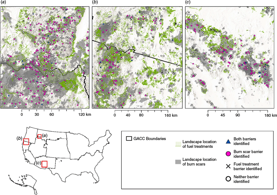
At landscape scale, clusters of incidents that identify burn scars and fuel treatments as barriers occur where they are locally abundant (Fig. 2). On the scale of individual incidents, the amount of burn scar or fuel treatment available is also a control on the probability of a barrier being identified in the WFDSS. Fig. 3 shows the binomial probability of a fuel treatment or burn scar identified as a barrier in the WFDSS, based on the proportion of the surrounding landscape affected by treatment or fire. There is a strong positive relationship (P < 0.0001) between the proportion of land burned in a prior wildfire and the likelihood that fire managers will reference a burn scar as a barrier in the WFDSS at all neighborhood sizes. When half of the landscape surrounding an incident has burned previously, the probability of a burn scar being identified as a barrier exceeds 50% (Fig. 3).
Binomial probabilities of an incident having a fuel treatment identified as a barrier (left) or burn scar as a barrier (right) as a function of the proportion of the surrounding landscape treated or burned. Ribbons represent standard errors. Five neighborhoods, ranging from 1 to 50 km around each fire, were considered. Different domain lengths reflect varying landscape availability of fuel treatments. For example, no fire had more than 0.02% of the surrounding landscape treated within a 50 km buffer (purple ribbon, left panel).
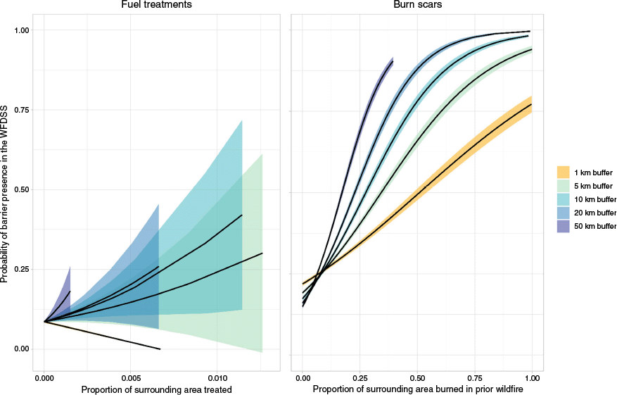
Although there is also a positive relationship between landscape treatment and the probability of a fire manager discussing a treatment, it is weaker and associated with greater error. However, the landscape thresholds at which fire managers begin discussing fuel treatments are much lower than burn scars. When 1% of a 5 km neighborhood is treated, approximately 25% of incidents recognize fuel treatment barriers. More than 20% of the same neighborhood must be burned for a quarter of incidents to have a burn scar identified as a barrier. Finally, fire managers sometimes identify fuel treatments that are not present in IFTDSS (~9% of incidents; Table 5), highlighting limitations of the federal reporting system. The same does not hold true for burn scars, which are almost universally identifiable on the landscapes of incidents where burn scars are identified as barriers.
| Search radius | |||||||
|---|---|---|---|---|---|---|---|
| 1 km | 5 km | 10 km | 20 km | 50 km | |||
| Fuel treatment not identifiable on the landscape | Fuel treatment not identified in WFDSS | 5867 | 5854 | 5834 | 5776 | 5593 | |
| Fuel treatment identified in WFDSS | 556 | 553 | 548 | 539 | 524 | ||
| Fuel treatment identifiable on the landscape | Fuel treatment not identified In WFDSS | 2 | 15 | 35 | 93 | 276 | |
| Fuel treatment identified in WFDSS | 0 | 3 | 8 | 17 | 32 | ||
Discussion
The WFDSS documents the thoughts, plans and perceptions of the people responsible for large wildfire response. It is not possible to tease out the relative contribution of the opinions and attitudes of individual authors in the writings of the WFDSS, but we assume that fire managers are more likely to identify barriers that they are personally familiar with, such as fuel treatments they had a hand in planning. Additionally, the WFDSS is a planning framework. It is unknown which barriers manifested into fire suppression strategies, which were utilized and failed, and which were never pursued. Despite these limitations, the WFDSS is a powerful source of information as a comprehensive archive of every major fire in the United States over the past 13 years in the words of the decision-makers. It shows that barriers, especially burn scars, roads and natural fuels variability, are in the forefront of decision-makers’ minds. Although the full WFDSS text is not currently publicly available, this study provides the most information that has ever been aggregated or published and is a step towards more transparency in decision-making.
This study utilized a commercially available LLM to parse and classify the WFDSS, which enabled the evaluation of 22 times more fires than previous studies (Noonan-Wright and Seielstad 2022). From the standpoint of high-quality interpretation of text, we found that a current commercially available LLM performed well when given a constrained problem that could be validated quantitatively. A census analysis would not have been possible without the use of an LLM in this study. However, the ‘gpt-4’ model is a black box in the sense that it was unknown what bodies of text were used to train it, the underlying model structure, or what biases it almost certainly holds (Zhou et al. 2024). This lack of transparency limits reproducibility both for our own modeling team and for external scientific scrutiny. Although reproducibility is a limitation of our approach, a few steps were taken to mitigate the black box issues inherent in commercially available LLMs. First, the model was constrained to 13 categorical options to limit task ambiguity for the model and complexity of interpretation for the researchers. The model was also tested for reproducibility to ensure it produced the same result when provided with the same body of text multiple times, which it did. The biases of the model do not appear greater than those innate in human interpretation (Table 3), and human readers would be the alternative available method if this study were to be conducted without the use of artificial intelligence.
Disagreement was low between human readers (8.52% of cases during validation) but indicates the complexity in interpreting domain-specific text even when read by experts. Additionally, hundreds of individual authors contributed to the WFDSS entries analyzed, and their ability to effectively communicate in writing varied akin to any other profession. Ultimately, the LLM performed similarly or slightly better than experienced firefighters on a subset of 260 incidents that were validated manually by human readers. The larger disagreements between interpretations were affected by small samples. For example, mechanical treatments were rare in the validation set (n = 10), reflecting the reality that treatments occur on a small fraction of the landscape in the US. Thus, results pertaining to fuel treatments should be interpreted cautiously. Although the use cases of mechanical fuel treatments in the WFDSS appear ambiguous in both human and model interpretation, we expect better agreement with larger sample sizes.
There are also practical and ethical considerations regarding using LLMs for science. The exact training sets behind commercial LLMs are propriety and unavailable to end-users. Over the course of this research, concerns regarding the treatment of intellectual property by the creators of ‘gpt-4’ were raised publicly (Claburn 2024). Additionally, LLMs hold the biases of their training text (Huang et al. 2025), and when trained on content scraped from the internet, encompass the biases that people hold and express online. Throughout this study, we strove to utilize the LLM as a methodological tool within the confines of the scientific method. Model outputs were formally validated against human interpretation and evaluated relative to empirical patterns in burn scar and fuel treatment locations. From an ethical standpoint, we also endorse the development of an open-source LLM specific to scientific research, with transparent, indexable training sets, the plasticity to fine-tune for specific applications and introduce fire-specific training corpora, and the ability to see and publish details of the underlying neural network. We also caution against the use of these models for original text generation or as a substitute for human judgement, echoing concerns that have already been raised extensively in the scientific community (Azamfirei et al. 2023; Zhou et al. 2024).
Barriers on the landscape
Most incidents in the WFDSS have barriers on their landscapes that are expected to slow fire spread. Incidents lacking barriers occur everywhere but more often in grasslands (Fig. 1), perhaps because previous wildfires and fuels treatments are less persistent in this vegetation type. Although roads, burn scars and natural fuel variability were the most identified barriers across the landscape, regional variability was present, (Table 4), and the most interesting patterns emerged where local dispatch centers deviated from regional and national trends, encapsulating highly local variability in fire culture and the barriers available. For example, on one Florida fire, managers describe a series of levees as barriers to fire spread. In rangelands across the western United States, managers were sensitive to livestock locations and occasionally noted where grazing reduced fuel loads.
Burn scars as barriers
The concept of selectively allowing wildfires to burn to reduce the risk of larger, more destructive fires is loosely embedded in fire policy (Stephens and Ruth 2005; Russell et al. 2024), but this is difficult to implement in practice in part because of risk perception (Noonan-Wright and Seielstad 2024). This study’s findings strongly support the idea that previous wildfires are among the most operationally useful landscape features for future fire suppression efforts, likely owing to their size, recency and ubiquity.
Burn scars were common on the landscapes of active incidents. An extensive body of work has found that fire is generally self-limiting in forested systems because it reduces the fuel available for future wildfires (Teske et al. 2012; Héon et al. 2014; Parks et al. 2014). Although the effect is dependent on weather conditions and time between fires (Collins et al. 2009; Parks et al. 2015), it is apparently strong enough for fire managers to discuss burn scars as barriers on more than a quarter of fires. For example, on a 2021 Eastern Area fire, managers write:
The community of [community] is at lower risk due to the large wildfires that have occurred in the past 15 years. Those large burn areas serve as large fuel breaks between the fire and [community].
Managers also notice the absence of burn scars on landscapes where they are usually part of the fire suppression toolkit. For example, on a 2022 Alaksa fire, managers write:
This part of the [zone] is not as dry in the deeper duff layers and has not experienced significant fire growth on any fires. Fire behavior has been moderate due to the mix hardwood component and the relatively moist duff layer. Early in the Alaska fire season. River to the east historically has been a reliable natural barrier. Lack of significant fire history in the planning area will allow for [the wildfire] to burn without fire scars to slow growth.
The likelihood that a burn scar is discussed as a barrier depends on the amount of burned landscape available (Fig. 3). When burn scars are available on the landscape, fire managers are highly likely to recognize them as potential barriers. The portions of the country that do not seem to leverage burn scars as barriers despite robust recent fire histories are concentrated in the Great Plains, eastern United States and less forested regions of the West. The eastern US perhaps represents more populated areas less tolerant of indirect fire suppression strategies. In less-forested parts of the West and Great Plains, burn scars may be less strategically useful because the fuel reduction effect of fire is less persistent in shrub and grassland than in forests due to differing relative productivity and subsequent fuel availability for future fires (Pausas and Ribeiro 2013).
Fuel treatments as barriers
Fuel treatments were relatively rare on the landscapes of WFDSS fires. Our findings indicate that large wildfires are unlikely to occur near a fuel treatment, and prior work indicates that less than 7% of fuel treatments ever encounter wildfire in their useful lifespan (Barnett et al. 2016). This lack of intersection, whether viewed as fire reaching fuel treatments or fuel treatments encountering fire, has a complicated implication for fire management. More treatments such as are currently being delivered by the Bipartisan Infrastruture Law (US Department of Agriculture 2023; US Department of Interior 2023) are likely to make a difference, but this difference is expected to be small relative to burn scars and natural fuels variability given the disparity in area treated relative to land area impacted by natural processes and variability. Despite their rarity, fire managers begin discussing fuel treatments as barriers when relatively low proportions of the landscape are impacted compared to burn scars. When 1% of a 5 km neighborhood around an incident is treated, 25% of incidents mention a fuel treatment. In contrast, over 20% of the same area must be burned for 25% of incidents to discuss a burn scar as a barrier. There is a growing body of empirical (McKinney et al. 2022) and simulated (Ott et al. 2023) evidence that fuel treatments moderate fire behavior in some cases outside the bounds of the treated areas, and perhaps fire managers are leveraging the perceived outsized impacts of treatments on their surrounding landscape. Additionally, there is an element of randomness to burn scar locations, while significant thought usually goes into optimizing fuel treatment placement. Size (Seto et al. 2022), prescription (Schwilk et al. 2009) and age (Vaillant et al. 2015) each impact the effectiveness of a treatment. Quantifying the characteristics of the fuel treatments discussed in the WFDSS more precisely would be a worthy follow-up to this study.
Mechanical treatments rearrange the flammable material on a site, but do not always change the net energy available for combustion, and treated sites often have greater surface fuel loads than untreated counterparts (Stephens et al. 2009; Vaillant et al. 2015). During model development, we noticed several cases where fire managers in the WFDSS appear to discuss situations where fuel treatments worsened fire behavior. For example, on a 2014 Rocky Mountain Region fire, managers write:
Recent fuels reduction thinning completed during 2012–2014 have left several pockets of untreated slash on the ground; fire appears to have moved into these areas with extreme fire behavior including significant convection column with associated spotting.
Similarly, on a 2015 Northern Rockies fire, managers note:
There are some fuel breaks around the fire location consisting of old cutting units; if the slash was treated, these will likely be barriers to fire spread… The lowlands of the forest has been in Stage 2 restrictions for approximately a month, the highlands have been in and are now in Stage 1 restrictions due to fire potential. There are some barriers around the fire area consisting of roads and some cutting units. The cutting units will only be an effective barrier if the fuels have been treated post-harvest; if not, these areas will be highly receptive for fire spread.
The LLM was manipulated to exclude references to fuel treatments that did not serve as barriers, so the number of cases where ongoing forest management exacerbated fire behavior is unknown. However, an important management implication of this work is that fuel treatments are not categorically helpful at moderating fire behavior, particularly while they are under construction.
Fuel treatments not identifiable in the IFTDSS
Many of the incidents that discuss fuel treatments in the WFDSS do not have one readily identifiable nearby in the federal IFTDSS database. This introduces a degree of error into the binomial models in Fig. 3 by underestimating the proportion of landscape treated around some incidents. The same does not hold true for burn scars, which were almost universally identifiable on the landscape when fire managers discussed them.
There are several reasons for the observed discrepancy between the writings of WFDSS authors and what is documented in IFTDSS. Fire managers often reference a fuel treatment that has been constructed to meet incident objectives in the course of a long-duration fire. These treatments were completed during active emergency management and do not undergo formal planning. For example, on a 2019 Pacific Northwest fire, managers discuss a treatment completed on a nearby fire 2 years prior.
The point of origin has the [two prior wildfires] fire scars on the south, west, (uphill), and east sides of the fire perimeter. While there is still approximately 6 weeks of fire season left, multiple wetting rain events and cooler temperatures have lessened the likelihood of experiencing large fire growth days in the remainder of fire season. An extensive fuel break was also created along the east side of the 13 Rd. during the 2017 [prior wildfire].
Fire managers also discuss treatments on private land, which are not documented in federal IFTDSS datasets but are still advantageous for interjurisdictional fire. For example, managers on a 2019 Northern Rockies fire write:
Rough terrain, and heavy juniper. The private lands adjacent to the fire have been mechanically treated extending containment strategies.
The present study also only considered completed treatments. There were multiple instances in the WFDSS of fire managers appearing to harness preparatory work done on planned units or units in progress. For example, managers on a 2023 Great Basin fire wrote:
Terrain and fuels are varied. Multiple fire return intervals have been missed; the immediate fire area lacks fire history. Current fire behavior is creeping through heavy dead and down fuels. Current live fuel moistures will limit fire spread; however this could change with a week to two weeks of drying… The fire is located within a planned fuel reduction/habitat restoration project area. Environmental analysis and planning has been completed along with preparation for firing activity.
Similarly, on a 2014 Southwest fire, managers write:
Barriers have been created in preparation for the prescribed fire planned for this fall.
Lastly, there were several instances in the WFDSS where fire managers cited specific, named treatments that could not be corroborated by either name or location in the IFTDSS, indicating potential documentation holes in the federal system.
Conclusion
This study leveraged a large language model to analyze 13 years of wildfire decision-making records from the WFDSS, providing unprecedented insight into how fire managers perceive and utilize landscape features as barriers to fire spread. Although commercially available large language models are black boxes that pose challenges to reproducibility, we found the gpt-4 model to be useful when given a constrained problem and validated against human interpretation. There are limitations innate to narrative text, but this approach represents a method for systematically extracting meaningful information from a very large, unorganized body of text.
Fire managers recognize barriers on most wildfires (75%) and identify explicitly when they do not exist. Roads, burn scars and naturally sparse fuel were the most common barriers discussed in the WFDSS. The presence of burn scars on the landscape is strongly correlated with their identification as a suppression tool, supporting the idea that natural wildfire yields highly effective footholds for stopping subsequent fires. In contrast, fuel treatments were rarely encountered by large wildfires, but when present, they were often recognized as strategic barriers even when they covered only a small portion of the landscape. This suggests that fuel treatments may exert outsized influence in decision-making. Our findings also highlight key management challenges. Some fuel treatments were reported as exacerbating fire behavior owing to untreated slash or other fuel characteristics, reinforcing the importance of prescription, design and implementation. Additionally, non-federal fuel treatments and treatments built over the course of active incidents appear to be important to fire managers, highlighting the need for better national tracking of fuel treatments. Ultimately, this study provides a retrospective look at fuel treatment use that can complement the empirical and modeled body of work evaluating treatment effectiveness. Improving understanding of how fire managers perceive and deploy barriers may allow better alignment of policy and practice to optimize landscape opportunities to stop fire spread and moderate the changing risk environment.
Data availability
WFDSS data are not publicly available owing to the sensitive nature of emergency response decisions. MTBS fire perimeters used in this analysis are available at https://www.mtbs.gov/direct-download and IFTDSS fuel treatment locations are available at https://nifc.hub.arcgis.com/datasets/nifc::integrated-interagency-fuels-treatments-view/explore.
Declaration of funding
This material is based on work supported by the National Science Foundation (NSF) EPSCoR Cooperative Agreement OIA-2242802 and the National Center for Landscape Fire Analysis (NCLFA). Any opinions, findings and conclusions or recommendations expressed in this material are those of the author(s) and do not necessarily reflect the views of NSF or NCLFA.
References
Abatzoglou JT, Williams AP, Barbero R (2019) Global emergence of anthropogenic climate change in fire weather indices. Geophysical Research Letters 46(1), 326-336.
| Crossref | Google Scholar |
Azamfirei R, Kudchadkar SR, Fackler J (2023) Large language models and the perils of their hallucinations. Critical Care 27(1), 120.
| Crossref | Google Scholar | PubMed |
Barnett K, Parks S, Miller C, Naughton H (2016) Beyond fuel treatment effectiveness: characterizing interactions between fire and treatments in the US. Forests 7(12), 237.
| Crossref | Google Scholar |
Benoit K, Watanabe K, Wang H, Nulty P, Obeng A, Müller S, Matsuo A (2018) quanteda: an R package for the quantitative analysis of textual data. Journal of Open Source Software 3(30), 774.
| Crossref | Google Scholar |
Boiko DA, MacKnight R, Kline B, Gomes G (2023) Autonomous chemical research with large language models. Nature 624(7992), 570-578.
| Crossref | Google Scholar | PubMed |
Claburn T (2024) OpenAI to reveal secret training data in copyright case – for lawyer’s eyes only. The Register. Available at https://www.theregister.com/2024/09/26/openai_training_data_author_copyright_case/
Cochrane MA, Bowman DMJS (2021) Manage fire regimes, not fires. Nature Geoscience 14(7), 455-457.
| Crossref | Google Scholar |
Collins BM, Miller JD, Thode AE, Kelly M, van Wagtendonk JW, Stephens SL (2009) Interactions among wildland fires in a long-established Sierra Nevada natural fire area. Ecosystems 12(1), 114-128.
| Crossref | Google Scholar |
Eidenshink J, Schwind B, Brewer K, Zhu Z-L, Quayle B, Howard S (2007) A project for monitoring trends in burn severity. Fire Ecology 3(1), 3-21.
| Crossref | Google Scholar |
Finney MA (2001) Design of regular landscape fuel treatment patterns for modifying fire growth and behavior. Forest Science 47(2), 219-228.
| Crossref | Google Scholar |
Finney MA, Seli RC, McHugh CW, Ager AA, Bahro B, Agee JK (2007) Simulation of long-term landscape-level fuel treatment effects on large wildfires. International Journal of Wildland Fire 16(6), 712-727.
| Crossref | Google Scholar |
Greiner SM, Schultz C, Novak KM, Lohman A (2025) The role of fuel treatments during incident management. Fire Ecology 21, 25.
| Crossref | Google Scholar |
Hagmann RK, Hessburg PF, Prichard SJ, Povak NA, Brown PM, Fulé PZ, Keane RE, Knapp EE, Lydersen JM, Metlen KL, Reilly MJ, Sánchez Meador AJ, Stephens SL, Stevens JT, Taylor AH, Yocom LL, Battaglia MA, Churchill DJ, Daniels LD, Falk DA, Henson P, Johnston JD, Krawchuk MA, Levine CR, Meigs GW, Merschel AG, North MP, Safford HD, Swetnam TW, Waltz AEM (2021) Evidence for widespread changes in the structure, composition, and fire regimes of western North American forests. Ecological Applications 31(8), e02431.
| Crossref | Google Scholar | PubMed |
Héon J, Arseneault D, Parisien M-A (2014) Resistance of the boreal forest to high burn rates. Proceedings of the National Academy of Sciences 111(38), 13888-13893.
| Crossref | Google Scholar | PubMed |
Higuera PE, Abatzoglou JT (2021) Record‐setting climate enabled the extraordinary 2020 fire season in the western United States. Global Change Biology 27(1), 1-2.
| Crossref | Google Scholar | PubMed |
Higuera PE, Cook MC, Balch JK, Stavros EN, Mahood AL, St. Denis LA (2023) Shifting social-ecological fire regimes explain increasing structure loss from Western wildfires. PNAS Nexus 2(3), pgad005.
| Crossref | Google Scholar | PubMed |
Huang L, Yu W, Ma W, Zhong W, Feng Z, Wang H, Chen Q, Peng W, Feng X, Qin B, Liu T (2025) A survey on hallucination in large language models: principles, taxonomy, challenges, and open questions. ACM Transactions on Information Systems 43(2), 1-55.
| Crossref | Google Scholar |
Jones GM, Spannuth A, Chongpinitchai A, Hurteau MD (2025) Prescribed fire, managed burning, and previous wildfires reduce the severity of a southwestern US gigafire. Forest Ecology and Management 580, 122540.
| Crossref | Google Scholar |
Kalies EL, Yocom Kent LL (2016) Tamm Review: are fuel treatments effective at achieving ecological and social objectives? A systematic review. Forest Ecology and Management 375, 84-95.
| Crossref | Google Scholar |
Kim H, Na J, Lee WB (2021) Generative chemical transformer: neural machine learning of molecular geometric structures from chemical language via attention. Journal of Chemical Information and Modeling 61(12), 5804-5814.
| Crossref | Google Scholar | PubMed |
Luo R, Sun L, Xia Y, Qin T, Zhang S, Poon H, Liu T-Y (2022) BioGPT: generative pre-trained transformer for biomedical text generation and mining. Briefings in Bioinformatics 23(6),.
| Crossref | Google Scholar | PubMed |
McHugh ML (2012) Interrater reliability: the kappa statistic. Biochemia Medica 22(3), 276-282.
| Google Scholar | PubMed |
McKinney ST, Abrahamson I, Jain T, Anderson N (2022) A systematic review of empirical evidence for landscape-level fuel treatment effectiveness. Fire Ecology 18(1), 21.
| Crossref | Google Scholar |
Moghaddas JJ, Craggs L (2007) A fuel treatment reduces fire severity and increases suppression efficiency in a mixed conifer forest. International Journal of Wildland Fire 16(6), 673-678.
| Crossref | Google Scholar |
Noonan-Wright E, Seielstad CA (2021) Patterns of wildfire risk in the United States from systematic operational risk assessments: how risk is characterised by land managers. International Journal of Wildland Fire 30(8), 569-584.
| Crossref | Google Scholar |
Noonan-Wright E, Seielstad C (2022) Factors influencing risk during wildfires: contrasting divergent regions in the US. Fire 5(5), 131.
| Crossref | Google Scholar |
Noonan-Wright E, Seielstad C (2024) Wildfire management strategy and its relation to operational risk. Journal of Forestry 122(4), 352-362.
| Crossref | Google Scholar |
Noonan-Wright EK, Opperman TS, Finney MA, Zimmerman GT, Seli RC, Elenz LM, Calkin DE, Fiedler JR (2011) Developing the US Wildland Fire Decision Support System. Journal of Combustion 2011, 168473.
| Crossref | Google Scholar |
OpenAI, Achiam J, Adler S, Agarwal S, Ahmad L, Akkaya I, Aleman FL, Almeida D, Altenschmidt J, Altman S, Anadkat S, Avila R, Babuschkin I, Balaji S, Balcom V, Baltescu P, Bao H, Bavarian M, Belgum J, Bello I, Berdine J, Bernadett-Shapiro G, Berner C, Bogdonoff L, Boiko O, Boyd M, Brakman A-L, Brockman G, Brooks T, Brundage M, Button K, Cai T, Campbell R, Cann A, Carey B, Carlson C, Carmichael R, Chan B, Chang C, Chantzis F, Chen D, Chen S, Chen R, Chen J, Chen M, Chess B, Cho C, Chu C, Chung HW, Cummings D, Currier J, Dai Y, Decareaux C, Degry T, Deutsch N, Deville D, Dhar A, Dohan D, Dowling S, Dunning S, Ecoffet A, Eleti A, Eloundou T, Farhi D, Fedus L, Felix N, Fishman SP, Forte J, Fulford I, Gao L, Georges E, Gibson C, Goel V, Gogineni T, Goh G, Gontijo-Lopes R, Gordon J, Grafstein M, Gray S, Greene R, Gross J, Gu SS, Guo Y, Hallacy C, Han J, Harris J, He Y, Heaton M, Heidecke J, Hesse C, Hickey A, Hickey W, Hoeschele P, Houghton B, Hsu K, Hu S, Hu X, Huizinga J, Jain S, Jain S, Jang J, Jiang A, Jiang R, Jin H, Jin D, Jomoto S, Jonn B, Jun H, Kaftan T, Kaiser Ł, Kamali A, Kanitscheider I, Keskar NS, Khan T, Kilpatrick L, Kim JW, Kim C, Kim Y, Kirchner JH, Kiros J, Knight M, Kokotajlo D, Kondraciuk Ł, Kondrich A, Konstantinidis A, Kosic K, Krueger G, Kuo V, Lampe M, Lan I, Lee T, Leike J, Leung J, Levy D, Li CM, Lim R, Lin M, Lin S, Litwin M, Lopez T, Lowe R, Lue P, Makanju A, Malfacini K, Manning S, Markov T, Markovski Y, Martin B, Mayer K, Mayne A, McGrew B, McKinney SM, McLeavey C, McMillan P, McNeil J, Medina D, Mehta A, Menick J, Metz L, Mishchenko A, Mishkin P, Monaco V, Morikawa E, Mossing D, Mu T, Murati M, Murk O, Mély D, Nair A, Nakano R, Nayak R, Neelakantan A, Ngo R, Noh H, Ouyang L, O’Keefe C, Pachocki J, Paino A, Palermo J, Pantuliano A, Parascandolo G, Parish J, Parparita E, Passos A, Pavlov M, Peng A, Perelman A, Peres F de AB, Petrov M, Pinto HP de O, Pokorny M, Pokrass M, Pong VH, Powell T, Power A, Power B, Proehl E, Puri R, Radford A, Rae J, Ramesh A, Raymond C, Real F, Rimbach K, Ross C, Rotsted B, Roussez H, Ryder N, Saltarelli M, Sanders T, Santurkar S, Sastry G, Schmidt H, Schnurr D, Schulman J, Selsam D, Sheppard K, Sherbakov T, Shieh J, Shoker S, Shyam P, Sidor S, Sigler E, Simens M, Sitkin J, Slama K, Sohl I, Sokolowsky B, Song Y, Staudacher N, Such FP, Summers N, Sutskever I, Tang J, Tezak N, Thompson MB, Tillet P, Tootoonchian A, Tseng E, Tuggle P, Turley N, Tworek J, Uribe JFC, Vallone A, Vijayvergiya A, Voss C, Wainwright C, Wang JJ, Wang A, Wang B, Ward J, Wei J, Weinmann C, Welihinda A, Welinder P, Weng J, Weng L, Wiethoff M, Willner D, Winter C, Wolrich S, Wong H, Workman L, Wu S, Wu J, Wu M, Xiao K, Xu T, Yoo S, Yu K, Yuan Q, Zaremba W, Zellers R, Zhang C, Zhang M, Zhao S, Zheng T, Zhuang J, Zhuk W, Zoph B (2023) GPT-4 Technical Report. (OpenAI)
Ott JE, Kilkenny FF, Jain TB (2023) Fuel treatment effectiveness at the landscape scale: a systematic review of simulation studies comparing treatment scenarios in North America. Fire Ecology 19(1), 10.
| Crossref | Google Scholar |
Parks SA, Abatzoglou JT (2020) Warmer and drier fire seasons contribute to increases in area burned at high severity in western US forests from 1985 to 2017. Geophysical Research Letters 47, e2020GL089858.
| Crossref | Google Scholar |
Parks SA, Miller C, Nelson CR, Holden ZA (2014) Previous fires moderate burn severity of subsequent wildland fires in two large western US wilderness areas. Ecosystems 17(1), 29-42.
| Crossref | Google Scholar |
Parks SA, Holsinger LM, Miller C, Nelson CR (2015) Wildland fire as a self-regulating mechanism: the role of previous burns and weather in limiting fire progression. Ecological Applications 25(6), 1478-1492.
| Crossref | Google Scholar | PubMed |
Pausas JG, Keeley JE (2009) A burning story: the role of fire in the history of life. BioScience 59(7), 593-601.
| Crossref | Google Scholar |
Pausas JG, Ribeiro E (2013) The global fire–productivity relationship. Global Ecology and Biogeography 22(6), 728-736.
| Crossref | Google Scholar |
Prichard SJ, Kennedy MC (2014) Fuel treatments and landform modify landscape patterns of burn severity in an extreme fire event. Ecological Applications 24(3), 571-590.
| Crossref | Google Scholar | PubMed |
Radeloff VC, Helmers DP, Kramer HA, Mockrin MH, Alexandre PM, Bar-Massada A, Butsic V, Hawbaker TJ, Martinuzzi S, Syphard AD, Stewart SI (2018) Rapid growth of the US wildland–urban interface raises wildfire risk. Proceedings of the National Academy of Sciences 115(13), 3314-3319.
| Crossref | Google Scholar | PubMed |
Rives A, Meier J, Sercu T, Goyal S, Lin Z, Liu J, Guo D, Ott M, Zitnick CL, Ma J, Fergus R (2021) Biological structure and function emerge from scaling unsupervised learning to 250 million protein sequences. Proceedings of the National Academy of Sciences 118(15), e2016239118.
| Crossref | Google Scholar | PubMed |
Russell A, Fontana N, Hoecker T, Kamanu A, Majumder R, Stephens J, Young AM, Cravens AE, Giardina C, Hiers K, Littell J, Terando A (2024) A fire-use decision model to improve the United States’ wildfire management and support climate change adaptation. Cell Reports Sustainability 1(6), 100125.
| Crossref | Google Scholar |
Schwilk DW, Keeley JE, Knapp EE, McIver J, Bailey JD, Fettig CJ, Fiedler CE, Harrod RJ, Moghaddas JJ, Outcalt KW, Skinner CN, Stephens SL, Waldrop TA, Yaussy DA, Youngblood A (2009) The national Fire and Fire Surrogate study: effects of fuel reduction methods on forest vegetation structure and fuels. Ecological Applications 19(2), 285-304.
| Crossref | Google Scholar | PubMed |
Seto D, Jones C, Trugman AT, Varga K, Plantinga AJ, Carvalho LM V, Thompson C, Gellman J, Daum K (2022) Simulating potential impacts of fuel treatments on fire behavior and evacuation time of the 2018 Camp Fire in northern California. Fire 5(2), 37.
| Crossref | Google Scholar |
Steel ZL, Safford HD, Viers JH (2015) The fire frequency–severity relationship and the legacy of fire suppression in California forests. Ecosphere 6(1), 1-23.
| Crossref | Google Scholar |
Stephens SL, Ruth LW (2005) Federal forest‐fire policy in the United States. Ecological Applications 15(2), 532-542.
| Crossref | Google Scholar |
Stephens SL, Moghaddas JJ, Edminster C, Fiedler CE, Haase S, Harrington M, Keeley JE, Knapp EE, McIver JD, Metlen K, Skinner CN, Youngblood A (2009) Fire treatment effects on vegetation structure, fuels, and potential fire severity in western U.S. forests. Ecological Applications 19(2), 305-320.
| Crossref | Google Scholar | PubMed |
Teske CC, Seielstad CA, Queen LP (2012) Characterizing fire-on-fire interactions in three large wilderness areas. Fire Ecology 8(2), 82-106.
| Crossref | Google Scholar |
US Department of Agriculture (2023) Biden–Harris Administration invests $63m for fuel breaks to protect communities, increase firefighter safety, as part of investing in America agenda. Available at https://www.usda.gov/about-usda/news/press-releases/2023/05/04/biden-harris-administration-invests-63m-fuel-breaks-protect-communities-increase-firefighter-safety
US Department of Interior (2023) Secretary Haaland announces nearly $50 million for wildfire mitigation and resilience from Bipartisan Infrastructure Law. Available at https://www.doi.gov/pressreleases/secretary-haaland-announces-nearly-50-million-wildfire-mitigation-and-resilience
US Department of Interior (2024) Biden–Harris administration outlines strategic priorities to strengthen the nation’s response to wildfire. Available at https://www.usda.gov/about-usda/news/press-releases/2024/06/03/biden-harris-administration-outlines-strategic-priorities-strengthen-nations-response-wildfire
US Department of the Interior, US Department of Agriculture (2024) Interagency Fuel Treatment Decision Support System (IFTDSS). Available at https://iftdss.firenet.gov/
US Forest Service (2022) Confronting the wildfire crisis: a strategy for protecting communities and improving resilience in America’s forest. Available at https://www.fs.usda.gov/sites/default/files/Confronting-Wildfire-Crisis.pdf
Vaillant NM, Noonan-Wright EK, Reiner AL, Ewell CM, Rau BM, Fites-Kaufman JA, Dailey SN (2015) Fuel accumulation and forest structure change following hazardous fuel reduction treatments throughout California. International Journal of Wildland Fire 24(3), 361-371.
| Crossref | Google Scholar |
Wickham H (2023) stringr: Simple, Consistent Wrappers for Common String Operations. R package version 1.5.1. Available at https://github.com/tidyverse/stringr, https://stringr.tidyverse.org
Zhou J, Müller H, Holzinger A, Chen F (2024) Ethical ChatGPT: concerns, challenges, and commandments. Electronics 13(17), 3417.
| Crossref | Google Scholar |