

Historical patterns of wildfire ignition sources in California ecosystems
Jon E. Keeley A B and Alexandra D. Syphard CA US Geological Survey, Western Ecological Research Center, Sequoia–Kings Canyon Field Station, 47050 Generals Highway, Three Rivers, CA 93271, USA.
B Department of Ecology and Evolutionary Biology, University of California, 612 Charles E. Young Drive East, Los Angeles, CA 90095, USA.
C Conservation Biology Institute, 10423 Sierra Vista Avenue, La Mesa, CA 91941, USA.
D Corresponding author. Email: jon_keeley@usgs.gov
International Journal of Wildland Fire 27(12) 781-799 https://doi.org/10.1071/WF18026
Submitted: 20 February 2018 Accepted: 25 September 2018 Published: 7 November 2018
Journal compilation © IAWF 2018 Open Access CC BY-NC-ND
Abstract
State and federal agencies have reported fire causes since the early 1900s, explicitly for the purpose of helping land managers design fire-prevention programs. We document fire-ignition patterns in five homogenous climate divisions in California over the past 98 years on state Cal Fire protected lands and 107 years on federal United States Forest Service lands. Throughout the state, fire frequency increased steadily until a peak c. 1980, followed by a marked drop to 2016. There was not a tight link between frequency of ignition sources and area burned by those sources and the relationships have changed over time. Natural lightning-ignited fires were consistently fewer from north to south and from high to low elevation. Throughout most of the state, human-caused fires dominated the record and were positively correlated with population density for the first two-thirds of the record, but this relationship reversed in recent decades. We propose a mechanistic multi-variate model of factors driving fire frequency, where the importance of different factors has changed over time. Although ignition sources have declined markedly in recent decades, one notable exception is powerline ignitions. One important avenue for future fire-hazard reduction will be consideration of solutions to reduce this source of dangerous fires.
Additional keywords: arson, debris burning, equipment, lightning, powerlines, smoking.
Introduction
Increasing concern over wildfires has prompted a re-emphasis by the federal government to stop this trend (https://www.doi.gov/pressreleases/secretary-zinke-directs-interior-bureaus-take-aggressive-action-prevent-wildfires, accessed 1 April 2018; Bedard 2017). For many decades, the focus of fire management has been on fuel modification with success on certain landscapes (Kalies and Kent 2016) but limited improvement on others (Keeley and Safford 2016). Because humans are a dominant ignition source over the majority of North America (Balch et al. 2017; Syphard et al. 2017) there is reason to believe improvements in fire prevention may be a key to reducing fire impacts. Indeed, the United States Forest Service (USFS) has been reporting fire causes since it began collecting systematic data on fires in 1905, with the explicit purpose of helping land managers design fire prevention programs (Donoghue 1982a).
Effective fire-prevention requires a sound understanding of the patterns and causes of fire ignitions, which are closely aligned with both human and biophysical-landscape characteristics (Syphard et al. 2008). Prestemon et al. (2013) suggested a conceptual model that linked ignitions to changes in biophysical, societal, prevention and management variations that illustrates the complexities of ascertaining relationships between different sources and how they change over time.
An important characterisation of anthropogenic ignitions is that the most abundant ignition sources are not always associated with the greatest area burned (Syphard and Keeley 2016). Thus, a topic in need of further study is how to sort out those ignition sources that are most damaging, how those have changed over time, and in light of future needs, how climate change is likely to affect different ignition sources and losses. For example, it has been demonstrated for the state of Victoria, Australia, that some ignition sources, such as electrical distribution lines, may be limited in number but result in much more severe fire consequences (Miller et al. 2017). In addition, these fires are more likely during periods of elevated fire danger. If some ignition sources play a larger role in area burned, these might be targets for closer scrutiny and fire-management planning. This potential has been demonstrated for parts of southern California over recent decades, where powerlines have been shown to cause a substantial amount of area burned in both subregions in southern California (Syphard and Keeley 2015). Other important factors were arson in one subregion and equipment in another.
The goal of the present research is to expand that approach to include the entire written history of fires in the state. Our focus was on the spatial and temporal patterns of different ignition sources and the relationship between type of ignition and area burned. We took a long-term historical approach utilising data from 1910 to 2016 for USFS lands and from 1919 to 2016 for state protected Cal Fire lands. First, we examine the spatial and temporal patterns of natural lightning-ignited fires v. human fires in the state, and their contribution to area burned. Next, we investigated which anthropogenic causes are most frequent, their distribution within the state, their change over time and their contribution to area burned. Based on a study of state-protected lands in California, Syphard et al. (2007) found that fires increased from 1931 to the 1980s, but then decreased over the subsequent decades. A similar pattern for the whole state was also reported by Keeley and Syphard (2017) on both Cal Fire and USFS lands. Thus, the present study contrasts fire-ignition patterns within climatically homogenous sub-regions for the period before 1980 and for the period 1980–2016.We also investigated the extent to which seasonal climate parameters could explain patterns of ignitions and area burned for each type of ignition source.
Methods
Fire-history data for numbers of fires and area burned, by cause, were analysed separately for state-protected Cal Fire and federal USFS lands. Data for counties, forests and climate divisions were all normalised by the area protected each year and within each unit and expressed as number of fires, or hectares burned, per million hectares.
Cal Fire data included 51 of the state’s 58 counties (see Fig S1, available as Supplementary material to this paper) as 7 counties had limited fire activity or records. Fire statistics were from direct protection areas (DPA), which are mostly state-responsibility lands with smaller amounts of federal lands, and included the years 1919–2016, summarised by county. The term DPA was first used in 1986 and the area included was equivalent to what was called State Zone (1972–1985), Zones I and II (1945–1971) and Zones 1, 2, 3 (1919–1944). Cal Fire data from 1919 to 1930 are unpublished and were only available as typed reports at the California State Archives in Sacramento. Data from 1931 to 2016 were available in annual reports variously named, Forest Fire Summary, Fire Statistics, Fire Activity Statistics, and Wildfire Activity Statistics, often referred to as the Redbook series, available from research libraries or directly from the agency. Only 30 counties had complete data (excluding 1927 for nearly all counties and a few additional years in other counties) beginning in 1919, and an additional 21 counties had continuous data beginning in 1945 (or slightly later in a few cases) (see Table S1 for years of records for each county). Area protected has changed through this period of record and thus data were normalised to the hectares protected for that year presented with the annual reports. There was a period from 1941 to 1952 area where protected-area data were not included in annual reports and, as best we can determine, those data are no longer available, so we used the areas protected in 1940. In all cases, the changes between 1940 and 1953, when such data were again available, were minor.
USFS fire data covered 17 national forests (Fig S2) and included the years 1910–2016 (see Table S2, two forests were created after 1910 carved out of area from adjoining forests). Area protected has changed through this period of record and thus data were normalised to the hectares protected for that year. Data for USFS lands through the 1980s were from annual fire statistics reports for Region 5, available in the Forestry Library (most of which was transferred to the Bioscience Library) at the University of California, Berkeley. More-recent data, 1970 to 2016, were from the National Wildfire Coordinating Group (see http://fam.nwcg.gov/fam-web/weatherfirecd/state_data.htm, accessed 1 June 2017).
Most investigators are unfamiliar with these historical fire records and are sometimes sceptical of their accuracy. For example, Stephens (2005) contended that USFS data before 1940 were inaccurate, but cited a source (Mitchell 1947) that provided no evidence of this. Likely, the idea comes from Donoghue’s (1982b) comment ‘1940 marked the modern era of fire reporting’. However, that comment was in reference to the fact that ‘the report issued at this time was the first designed for automated data processing and easy readability’ and was not in reference to reliability.
Historians have generally been confidant in these early California fire records (Brown 1945; Show 1945; Clar 1969; Cermak 2005). The first author, J. E. Keeley, examined all of the California fire-related materials stored at the state and federal archives and believes collectively they show managers have always been conscientious about reporting accuracy and completeness. For example, beginning in 1905, USFS record-keeping required 15 items of information on the fire reporting Form 944, including the specific cause (Donoghue 1982b). On state-protected lands there was an incentive in that the 1911 Federal Weeks Law provided fiscal aid to states based on statistics of fire protection (see http://www.calfire.ca.gov/about/about_calfire_history2, accessed 23 May 2018). In 1919, the California state legislature appropriated money for fire prevention and suppression, and records in the state archive show that, by 1920, there were more than 400 fire wardens distributed throughout the state who were charged with fire-fighting and fire reporting. In 1920, there were 800 flights of the Army’s 9th Aero Squadron fire patrol that covered 426 500 km during the 5-month California fire season (Cermak 1991).
One complication in studying ignition sources is that reported categories have changed over time. Certain causes have persisted over the entire period of record, including lightning, smoking and camping, but other categories have changed their names. For example, arson fires are a relatively new category as intentionally set fires have, in the past, been labelled as ‘incendiary’, and seem to have been more rural than contemporary urban arson fires (Kuhlken 1999) and in this paper they are all recorded as arson fires. Other changes include the term ‘brush burning’ being changed to ‘debris burning’, and the categorisation of brush burning has been folded into debris burning. Causes that were unknown or represented minor categories have been included as miscellaneous fires (Donoghue 1982a), but are not addressed here.
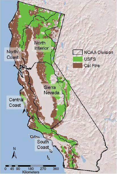
Cal Fire data were spatially explicit at the level of the county and USFS data at the level of the individual forest. However, for analysis, these were grouped into climatically homogenous areas as defined by the National Oceanic and Atmospheric Administration’s (NOAA) National Climatic Data Center (NCDC) California Climate Divisions (Fig. 1), comprising the main fire-prone landscapes in the state (see http://www.ncdc.noaa.gov/temp-and-precip/time-series/index.php?parameter=pdsi&month=1&year=2008&filter=p12&state=4&div=5, accessed 15 June 2016). These include, from north to south, Division 1 (North Coast), 2 (North Interior), 5 (Sierra Nevada), 4 (Central Coast), and 6 (South Coast). Where boundaries did not match precisely, counties or forests were placed in the climate division comprising the majority of land area in that unit.
|
In 1919, Cal Fire-protected lands were 11.7 × 10⁶ ha and increased to 12.5 × 10⁶ ha in 2016. USFS lands comprised 9.8 × 10⁶ ha in 1919 and decreased to 9.5 × 10⁶ ha in 2016. Vegetation on state lands was dominated by grasslands and shrublands in the south and with significant woodlands and coniferous forests farther north (see Keeley and Syphard 2017 for more detailed vegetation data). USFS lands were dominated by coniferous forests, except in the southern part of the state where they were dominated by shrublands.
To evaluate climate impact on fire activity, we utilised PRISM climate for each county on Cal Fire-protected lands and each forest on USFS lands (Fig. 1). For every year in the analysis, we extracted 2.5 arc-minute PRISM data (PRISM Climate Group, Oregon State University, see http://prism.oregonstate.edu, accessed 15 February 2017) for areas within the boundaries of the Cal Fire and USFS lands. For each county and forest, we computed area-weighted averages of monthly mean precipitation and temperature, summarised by season – winter being December (prior year), January and February, spring being March, April and May, summer being June, July and August, and autumn being September, October and November.
Analysis was conducted with Systat software (ver. 11.0, Systat Software, Inc., San Jose, CA, http://www.systat.com/). For the climate analysis, we developed multiple regression models explaining area burned for USFS and Cal Fire based on seasonal temperature, precipitation and prior-season precipitation variables. To ensure multicollinearity would not be an issue, we calculated correlation coefficients among all potential explanatory variables and eliminated those that were strongly correlated (P < 0.05) with other variables in the model.
Results
Long-term averages show that on a per-unit-area basis fires were approximately twice as frequent or more on Cal Fire lands as on USFS lands in all five NOAA climate divisions (Table 1). However, the relationship between ignitions and area burned varied markedly between Cal Fire and USFS lands and between divisions. In the North Coast division, Cal Fire dealt with twice as many fires as the USFS but the average area burned was very similar. In contrast, in the interior from the Sierra Nevada northward, Cal Fire experienced approximately double the number of fires and nearly double the area burned. In the coastal areas from San Francisco to San Diego, there were substantially more fires on Cal Fire-protected lands but the area burned was substantially greater on USFS lands.

|
For Cal Fire-protected landscapes, the area-based average number of fires per year (1919 to 2016) varied from 1645 in Placer County to 87 in Glenn County (Table 2). Humans were responsible for most of fires, accounting for 95% or more of the ignitions in two-thirds of the counties. However, certain northern California counties stood out as notable exceptions, e.g. in Siskiyou, Trinity, Lassen, Modoc and Plumas counties lightning accounted for one-quarter to more than half of all ignitions, patterns illustrated in Fig. 2a. Regions with the lowest lightning-ignited fires extended through the coastal ranges from north of San Francisco to Santa Barbara. Area burned by lightning-ignited fires generally followed a similar pattern, although it was the source for significant burning in the San Bernardino County of southern California (Fig. 3a).

|

|

|
For USFS lands, the area-based average number of fires per year (1910 to 2016) varied from 478 in San Bernardino to 67 in Eldorado National Forest (Table 3). Humans accounted for far fewer fires than on Cal Fire lands. In the South Coast division, humans were responsible for 74–88%; however, in half of the other forests, humans accounted for less than 50% of the fires. As with Cal Fire landscapes, USFS lightning-ignited fires were most common in the north-east part of the state and declined markedly in coastal central and southern California (Fig. 4a). Area burned by lightning-ignited fires generally followed a similar pattern with the exception that parts of the North Coast and Central Coast, despite having few such ignitions, had substantial area burned by this source (Fig. 5a).

|

|

|
On both Cal Fire- and USFS-protected lands, humans played a substantial role in fire ignitions. During the first two-thirds of the 20th century there was a very strong positive relationship between population density and fire frequency in nearly 90% of the counties (Table 2) and more than 75% of the forests (Table 3). However, from 1980 to 2016, although population growth continued throughout the state, in most counties and forests, population density exhibited a highly negative relationship with fire frequency (Tables 2, 3).
On both Cal Fire- and USFS-protected lands, human-ignited fires derived from both intentional and accidental causes. The highest number of fires was from equipment, arson, debris burning, children playing with fire, smoking, vehicles and powerlines (Tables S3–S6). Sources, such as railroads and lumber practices, did cause many fires in the early part of the record, but are of minor significance today (this change not shown).
These ignition sources exhibited marked geographical variation in their importance (Fig. 2–5). On lower elevation Cal Fire landscapes, arson was responsible for much of the area burned in the northern Sierra Nevada Mountains. (Fig. 3b), whereas debris burning was responsible for much of the area burned north and south of San Francisco (Fig. 3c), vehicles were the cause of much of the burning in the central coastal ranges (Fig. 3g) and equipment fires in southern California (Fig. 3f). Powerlines were responsible for significant number of fires in the north bay area of San Francisco and coastal communities from Santa Barbara south to the border (Fig. 3h).
In USFS forests, area burned in the South Coast was most heavily affected by arson and powerlines (Fig. 5b, h), but equipment and debris burning dominated in the Central Coast (Fig. 5c, f). Forests adjacent to high density metropolitan areas in Los Angeles and western San Bernardino counties had substantial burning due to smoking, children playing with fire, and powerlines (Fig. 5d, e, h).
Changing ignition patterns over time
The historical pattern of fire frequency on lower elevation Cal Fire-protected lands for 97 years and USFS lands for 107 years is illustrated in Fig. 6 for the five climate divisions. There was a common pattern across both Cal Fire and USFS lands and consistent within each of the five climate divisions – a highly significant increase in fire frequency from the beginning of records to 1979, and a switch to a highly significant decline in fires from 1980 to 2016 (Fig. 6), the single exception being the South Coast USFS lands (Fig. 6r). Despite a significant fit of these data to the linear regression models, there were some marked departures on Cal Fire lands during the early record. Plotting of linear regression residuals from 1919 to 1979 shows marked and consistent diversions in most divisions (Fig. 7). Although the residuals early in the record are closely aligned with the regression line, during the 1920s and 1930s from the Sierra Nevada north there was a marked increase in ignitions. This pattern was less obvious in coastal central and southern California. In the 1950s and 1960s, there was a marked depression in ignitions in all climate divisions. It is worth noting that in the former period it was drier than the long-term average and in the latter period wetter (Fig. S3).

|

|
Changes in area burned did not closely follow changes in fire frequency (Fig. 6) – while fire frequency increased in the first three-quarters of the 20th century, area burned declined or stayed more or less constant. USFS forests in the northern part of the state showed a tendency for increased area burned in the last 4 decades (Fig. 6d, l) but in general there were no strong trends in area burned after 1980.
Of particular interest is how specific ignition sources have changed and, in order to simplify this presentation, we have consolidated climate divisions in the north (North Coast, North Interior and Sierra Nevada) and in the south (Central Coast and South Coast), which is justified by the marked similarities in ignition patterns within these two regions (see Fig. 2–5).
On Cal Fire-protected lands, it is noteworthy that changes in number of ignitions for lightning-ignited fires matched that of many human ignition sources, specifically increased ignitions during the first part of the record and decreased ignitions in recent decades (Fig. 8a, e). Numbers of lightning ignitions were more than double in the north than in the south, and substantially fewer than the leading anthropogenic causes. On USFS forests, lighting fire frequency (Fig. 9a, e) followed a temporal pattern similar to Cal Fire lands but were ~3 times more abundant than on Cal Fire landscapes and were one of the dominant ignition sources in forests. Despite changes in number of lightning-ignited fires, the area burned by this source did not exhibit consistent trends, although, in northern California forests, area burned by lightning-ignited fires has increased since 1980 (Fig. 8i, m, 9i, m).

|

|
The main anthropogenic ignition sources on Cal Fire lands were arson, debris burning and smoking, and all showed a significant decrease in recent decades (Fig. 8b–d, f–h). Also, area burned by these ignition sources mostly showed a marked decrease in recent decades (Fig. 8j–l, n–p).
On USFS lands, arson and smoking were very important but camping was also a significant cause (Fig. 9). Arson fires exhibited remarkable similarity in the south of both jurisdictions with a marked decline in frequency and area burned since 1980 (Fig. 9f, n).
On both Cal Fire and USFS lands, some ignition sources, such as children playing with fire, equipment, vehicles and powerlines, were not specifically recorded during the early years (Fig. 10, 11). Children playing with fire declined significantly in both jurisdictions in the north and south (Fig. 10a, b, 11b, f) as did area burned by this source (Fig.10i, m, 11j, n). Equipment-ignited fires increased markedly between 1960 and 1979 on Cal Fire lands (Fig. 10b, f) but, during the same period, declined on USFS lands (Fig. 11c, g). Since 1980, this source of ignitions has declined sharply on Cal Fire lands in the north and south (Fig. 10b, f) but increased on USFS lands in the south (Fig. 11g). In contrast to all other ignition sources, powerline fires on Cal Fire and USFS lands in both the north and south have not declined in the last 4 decades (Fig. 10d, h, 11d, h) nor has area burned by this ignition source (Fig. 10p, 11p).

|

|
Climate relationships to ignitions
Based on the sharp change in ignition patterns through the period of record, it is critical to understand to what extent climate variation may have played a role. Considering the marked changes in climate over the period of this study (illustrated as decadal anomalies in seasonal temperature and precipitation in Fig S3), it is reasonable to expect climate variation has some explanatory value in understanding changes in ignition sources.
Multi-variate models used mean temperature and total precipitation for winter, spring, summer and autumn plus the prior-year winter–spring precipitation. Presented in Table 4 are those ignition sources with a significant P < 0.05 model. Not all ignition sources exhibited a significant climate mode and the models determining fire frequency were not the same as those for area burned. We note that, before 1980, the biggest driver of debris and railroad fires was prior-year precipitation. Since 1980, there was a negative relationship with summer temperature for debris burning, playing with fire, smoking and railroad fires. In the south, where lightning-ignited fires were uncommon (Fig. 2a), before 1980, they were strongly associated with high summer temperatures and autumn precipitation.
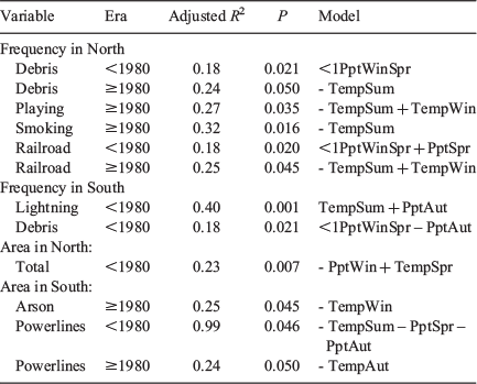
|
Total area burned on Cal Fire lands in the north before 1980 was significantly tied to low winter precipitation and high spring temperatures. In the south, area burned by both arson and powerlines was significantly tied to climate variation.
On USFS lands, total number of fires and area burned in both the north and south exhibited many significant climate models (Table 5). However, the patterns are complicated and not easily summarised as the specific climate models varied both spatially and temporally, as well as being different for different ignition sources.

|
For example, lightning fire frequency and area burned in both the north and south and before and after 1980 were significantly associated with climate variation, but, before 1980 in the north, the frequency of lightning fires was positively associated with summer precipitation, but the area burned was negatively associated with summer precipitation. After 1980 in the north, the model switched and there was a very strong effect of prior-year precipitation and summer temperature.
Since 1980, one of the strongest climate variables affecting both frequency and area burned was a positive relationship with prior-year precipitation. Although higher summer temperatures were associated with increased frequency of arson fires, it was noteworthy that lower summer temperatures were associated with an increased incidence of smoking, camping and children playing with fire in the north. Frequency of powerline fires were associated with elevated autumn temperatures and higher prior-year precipitation.
Cal Fire area-burned data were also presented by vegetation type and showed that in the north, forest and shrubland area burned had significant relationships with climate variation before 1980 but not afterwards (Table 6). In the south, grasslands had a significant climate model after 1980.
Discussion
Particularly striking about California ignitions is the steady increase in number of fires since the early 1900s until a peak c. 1980, followed by a marked drop in fire frequency up to 2016. This happened on both lower-elevation Cal Fire-protected lands and higher-elevation USFS lands, and in most climate divisions (Fig. 6). Despite a significant increase in fires during the first three-quarters of the 20th century, there were marked departures from this linear model, with accelerated ignitions during the 1920s and 1930s and a marked drop in the 1950s and 1960s (Fig. 7). Climate may have had some role in these changes since the former decade was drier and the latter was wetter (Fig S3) and during this period total fires on USFS lands did have a significant climate model largely driven by high summer temperatures and low summer precipitation (Table 4). What is particularly striking is the disconnect between number of ignitions and area burned; during the first three-quarters of the 20th century, although ignitions were increasing, area burned was steadily decreasing through much of the state.
In contrast, since 1980, ignitions have steadily declined, yet area burned has either not changed or, in some northern parts of the state, has increased. In short, the number of ignitions does not directly explain area burned. However, as discussed below, this conclusion does not apply to individual ignition sources, and, in this respect, there may be particular sources worth targeting for fire management purposes.
Factors that may have played a role in these historical patterns of ignitions and area burned are changes in: population density, infrastructure development, fire-prevention success, fire-suppression effectiveness, vegetation-management practices, climate, and possibly record-keeping accuracy. The drivers behind changes in ignition patterns are quite possibly different for different sources, different parts of the state and at different times. First, we consider the patterns for natural lightning-ignited v. human-caused wildfires.
Lightning-ignited fires
In California, natural lightning-ignited fires decreased from north to south and from high (USFS) to low (Cal Fire) elevation (Fig. 2, 4). On USFS lands, Lassen and Plumas forests in the north-east averaged over 150 lightning-ignited fires per year per million hectares, whereas the coastal Los Padres Forest averaged one-tenth as many (Table S5). In northern California forests, such as the Klamath, Lassen, Modoc, Inyo-Mono and Sequoia, lightning accounted for the majority of fires, and on many others it is about equally important as human-ignited fires (Table 3). Notable exceptions are the coastal Los Padres and southern California Angeles, Cleveland and San Bernardino forests, where lightning accounted for less than one-quarter of all fires. In contrast, on lower-elevation Cal Fire-protected lands, lightning accounted for less than 10% of all fires in most counties, and in coastal areas from Sonoma County south, typically <1% of all ignitions (Table 2). These patterns closely follow the distribution of lightning strikes in the state (van Wagtendonk and Cayan 2008). In general, lightning-ignited fires in coastal California were substantially less than that observed over much of the USA (Prestemon et al. 2013). Thus, the report that extreme fire events driven by high winds are commonly due to human ignitions and not lightning (Abatzoglou et al. 2018) should not be too surprising in California because these extreme winds are largely restricted to coastal areas in southern California and the San Francisco Bay Area.
Area burned by lightning-ignited fires approximately paralleled these geographical patterns with a couple noteworthy exceptions. In the northern and central part of the state, more coastal USFS forests had low lightning-ignited fire frequency but these accounted for a substantial amount of area burned, although this was less evident on lower-elevation Cal Fire lands (Fig. 2–5). For interior forests where lightning is the dominant ignition source, fires have proven to be reasonably easy to extinguish, in large part because they typically occur in forests with a low-intensity surface-fire regime, and during lightning-storm weather conditions (van Wagtendonk and Cayan 2008), are conducive to rapid fire control. As a consequence, less than 1% of these forest lands burn each year and these landscapes have a fire-rotation interval of 100–200 years (Table 1), very different with what is believed to be the natural fire interval (Stephens 2005; Van de Water and Safford 2011; Safford and Van de Water 2014). In coastal central and southern California, lightning accounts for very little area burned, in large part because lightning strikes are very low, but also because human-ignited fires often occur under weather conditions more conducive to fire spread, contributing to a shorter fire-rotation interval, e.g. 40–50 years on southern California forest lands (Table 1).
Lightning fires have increased markedly over most of the 20th century on both Cal Fire and USFS lands, in the north and south (Fig. 8, 9). A possible explanation for this pattern is improvement in detection, as lightning-ignited fires often occur in remote areas and detection may have been less effective in the early part of the 20th century and improved in the latter part of the 20th century. However, there is there is reason to retain some level of scepticism that this pattern is an artefact of reporting (see the ‘Methods’ section), primarily because state and federal agencies have put in extraordinary effort at fire detection since the early 1900s (Clar 1969; Cermak 2005), including hundreds of thousands of kilometres of wilderness aircraft fire patrols beginning in 1919 (Cermak 1991).
Another reason for not simply dismissing historical patterns as an artefact of reporting is that there are physical factors that could account for such changes. For example, one potential factor for a 20th-century rise in lightning fires could be changes in forest fuel structure, which has been shown to affect lightning-ignited fire frequency on other landscapes (Krawchuk et al. 2006). In California, this would be expected based on the marked drop in area burned following the burning peak in the 1920s – for both Cal Fire and USFS lands, three times more area burned in that decade relative to the decadal average burned from 1950 to 1980 (Keeley and Syphard 2017). Thus, during the mid-20th century there was potentially an increase in fuels that may have contributed to a greater chance of lightning strikes igniting fires.
Changes in reporting standards is also not likely to explain the pattern of decreased lightning-ignited fires from 1980 to 2016 (Fig. 8, 9). On Cal Fire and southern USFS lands, this did not produce any significant trend in area burned by this fire source, although northern California (including the Sierra Nevada) USFS lands showed an increase in area burned by this source, a pattern also seen in the northern Rocky Mountains (Stephens 2005). Climate is strongly implicated in this change (Table 5) as two-thirds of the annual variation in area burned by lightning-ignited fires is explained by a combination of prior-year precipitation and current-year summer temperature. Although the latter variable most likely affects fuel moisture at the time of fire, the former is thought to increase fires through its effect on herbaceous fuels in the following year (Littell et al. 2009; Crimmin and Comrie 2011; Keeley and Syphard 2016). A similar conclusion was drawn by Knapp (1995) for the climatic control of lightning-ignited fires in the Intermountain West.
The future projections are that lightning strikes will increase 50% over this century (Romps et al. 2014), but this is not easily translated into future lightning fire risks in California. Some landscapes, such as forests in the north-eastern part of the state, may already be saturated with lightning ignitions and coastal landscapes have very few strikes and thus a 50% increase may not significantly change lightning-ignited fire risk. In addition, changes in lightning-strike frequency will have very different impacts dependent on which season those changes occur in as well the state of future fuel conditions.
Human-ignition sources
The fact that in all climate divisions, the number of ignitions is not a monotonic function of time over the past 100 years suggests a complex model of how ignition sources affect burning activity. Prestemon et al. (2013) presented a conceptual model of biophysical, social, prevention and management drivers in controlling human ignition sources. These factors are not static, as illustrated by Guyette et al.’s (2002) dynamic anthropogenic fire regime model for the Ozark Mountains in Missouri. In their model, they found that the landscape changed over time from being ignition limited to fuel limited followed by stages dependent on fuel fragmentation and ultimately a culture-dependent stage. These temporal changes in drivers could explain a lot about the temporal changes observed in California ignitions.
It may be that the marked rise in ignitions during the first three-quarters of the 20th century in California is the result of increasing effectiveness of reporting, but this seems unlikely because the steepest rise in ignitions was in the latter part of the 20th century, i.e. 1960–1980 (Fig. 6). The 20th-century increase in ignitions was very strongly correlated with population growth (Tables 2, 3), but we believe that more is involved than just increasing population growth translates into more fires. This early–mid-20th-century growth spurt was correlated with road expansion throughout the state, which was bringing more people in contact with highly flammable fuels (Show 1945; Lockmann 1981; Keeley and Fotheringham 2003). In addition, because of migration patterns, growth included populations from less fire-prone parts of the US, and thus a population relatively naïve about the dangers of fire use in wildland areas (e.g. Zahn 1944; Show 1945). In addition, fire-prevention education was in its infancy and the population was slow to recognise their role in the fire problem. Included too is the widespread use of outdoor equipment that contributed to the sharpest rise in fires on Cal Fire landscapes between 1960 and 1980 (Fig. 10). On top of that, development of fire-response actions were far from perfect (Clar 1969). Also, during the period from 1940 to 1970 the State Resources Agency was actively involved in promoting burning of chaparral shrublands for the express purpose of type-converting native shrublands to exotic grasslands of greater economic value as rangelands (unpublished records in the State Archives). Indeed, the state was funding type conversion of private lands as this was perceived as a fire hazard reduction strategy, with an economic incentive of increasing rangeland.
Not directly related to changing demography is the significant decline in fires in the last several decades – while populations continued to grow after 1980, fire frequency was negatively related to population density (Tables 2, 3). This is consistent with the pattern of fire activity peaking under intermediate population density (Syphard et al. 2009). That is, the relationship between population density and ignition frequency is likely a function of finer-scale spatial processes regulating the degree of interspersion between development patterns and wildland vegetation. In other words, as both population and development expand into wildland areas, ignitions increase up to a point at which the area of development, or, impervious surface, far exceeds the area of wildland, and at that point, the relationship becomes negative. However, the timing of this switch varies with regions, e.g. south-east Australia continues to see a positive relationship in between population density and fire frequency (Collins et al. 2015).
Thus, these broad-scale patterns observed across the state may be reflecting macro-scale urbanisation trends over time. Massive areas of wildland vegetation have been developed and fragmented in California over the course of the 20th century (Hammer et al. 2007; Syphard et al. 2017), and the resulting extent and fragmentation of fuel surely has affected ignition trends and area burned. It may therefore be important to monitor areas that are becoming newly developed, as these may be the most fire-prone areas on the landscape, with sufficient people to start fires and wildland vegetation to carry fires (Radeloff et al. 2018).
Patterns such as these have been interpreted as indicating fires are not limited by human ignitions (Knorr et al. 2013; Moritz and Knowles 2016). This has prompted some to conclude that fire activity during the last several decades has been driven largely by climate change (Westerling et al. 2011). It is apparent that in mid–high-elevation forests in California seasonal climate variation has been an important factor in determining annual area burned (Table 5) and that global warming may exacerbate the fire situation on those landscapes (Keeley and Syphard 2016). However, in coastal California, climates are capable of generating large fire events most years (Keeley and Syphard 2017), with one exception being years with anomalous late spring rains (e.g. Dennison et al. 2008). In these coastal locations, big fire events occur during extreme wind events, however, these Santa Ana, Diablo or North Wind events occur predictably every year and yet big fires occur at unpredictable intervals, being determined by the coincidence of a human ignition with a wind event (Keeley and Zedler 2009).
During the first two-thirds of the 20th century more people translated into more fires, and greater fire activity. However, in recent decades the relationship between human population growth and fire activity has become more complex, nicely captured in Prestemon et al.’s (2013) model. In California in recent decades, increasing population density has increased the probability of ignitions under the worst weather conditions, either intentionally by arson for example or accidentally by powerline failures. This appears to be a widely seen situation throughout the USA where human-related ignitions are associated with conditions resulting in large wildfires (Nagy et al. 2018).
Decreasing ignitions over the last 4 decades is potentially reflective of increasing efficiency of fire prevention. However, it also likely reflects changes in human infrastructure; new roads in this era were tied to development projects that required demonstration of adequate fire response capabilities. In addition, an important factor behind declining ignitions is quite possibly the emergence of the California Fire Safe Council in the early 1990s (http://www.cafiresafecouncil.org/about-us/, accessed 11 August 2016), which made significant contributions to fire-safety education.
Arson has long been a major source of intentional human ignitions on both Cal Fire (Fig. 8) and USFS (Fig. 9) lands and on both jurisdictions arson ignitions increased during the first part of the 20th century and then dropped markedly in recent decades. Arson fires have always been one of the largest sources of area burned, although it was much higher in the early 20th century than in recent decades. This category comprises ignitions motivated for diverse reasons. Early in the 20th century, these were termed incendiary fires and were often motivated by goals of maintaining traditional burning practices (Coughlan 2016). As such practices became less socially (and legally) acceptable, the category was labelled arson fires. Arson fires exhibit interesting distribution patterns. On low-elevation Cal Fire lands they are a major ignition source in the northern Sierra Nevada (Fig. 2, 3) but on USFS lands they dominate in the southern part of the state (Fig. 4, 5), suggesting a need for more concentrated anti-arson prevention measures in those regions. This clustering of arson fires has been observed in parts of the Mediterranean basin and has prompted an early alert system (Gonzalez-Olabarria et al. 2012).
One of the real success stories illustrated by these data is the marked decline since 1980 in frequency and area burned by arson fires on both Cal Fire and USFS lands (Fig. 8, 9). This reduction in arson fires is a pattern observed for other parts of the country (Prestemon et al. 2013). In California, this may be attributed to better neighbourhood-watch programs, which include patrols during red-flag warnings, but broadcasted fire prevention messaging may also be a factor. Another factor may be increased penalties for arson; e.g. the person found guilty of starting the 2003 Old Fire in southern California was sentenced to death, as was the arson convicted of the 2006 Esperanza Fire (Gabbert 2012).
Another source of burning on both Cal Fire and USFS lands has been smoking. This was a significant cause in the earliest records, recording even ignitions from cigarettes thrown from open cockpit planes. Throughout the first half of the 20th century, smoking was a major cause of wildfires and was the focus of one of the earliest fire prevention campaigns. In 1942, over 100 000 ‘fag bags’ were distributed to persons entering the Angeles National Forest, bright red bags designed to carry smoking materials and with a prominent fire-safety reminder stamped on them (Show 1945). The late 20th-century decline in smoking caused such fires to decline at a much faster rate (Fig. 8, 9) than due to simple reduction in smoking (Prestemon et al. 2013). Reductions in smoking-caused fires are due to a combination of less smoking, more fire-resistant cigarettes, and improved fire prevention (Butry et al. 2014).
Children playing with fire has been an important ignition source and it has exhibited a marked decline in frequency in recent decades on both Cal Fire (Fig. 10) and USFS (Fig. 11) lands. Increased fire-prevention effectiveness through better messaging and development of childproof lighters are potential factors. Perhaps stricter ordinances in power-tool usage in wildlands under red-flag warnings may be a factor as well as requirements for more effective spark arrestors.
Vehicles present another accidental fire source that has declined sharply on Cal Fire protected lands. Catalytic converters, which were first required in 1975, are thought to have been a significant ignition factor (Bertagna 1999; http://www.cbs8.com/story/35871110/how-a-cars-catalytic-converter-can-spark-a-massive-fire, accessed 1 June 2017) when they overheated, igniting roadside vegetation. However, modern vehicles have warning lights when they overheat, which has the potential for reducing vehicle fires and could be a factor in the decline of such fires. Another factor potentially reducing vehicle fires is improved vegetation treatment along roadside verges.
Electrical powerlines have been reported ignition sources since 1905 (Show 1945). In the present study, this source of ignition stands out in that, unlike many other human ignition sources, powerline fires and area burned by this ignition source have not declined in recent decades (Fig. 10, 11). Although powerlines do not account for many fires, they often account for substantial area burned, and some of substantial size (Keeley et al. 2009; Syphard and Keeley 2015). One reason that powerline fires are so dangerous is that they commonly occur during high winds and there are three effects of these winds: tree contact, line arcing, and metal fatigue resulting in lines down (Mitchell 2009). These winds create extremely dangerous fires capable of rapid spread over long distances. This is a serious problem in other regions such as southern Australia where it was found that electricity-caused wildfires are over-represented when fire danger is high (Miller et al. 2017) and similar conclusions were drawn by Ganteaume and Guerra (2018). Powerline distribution tends to follow roads and this may be part of the reason burning patterns are closely correlated with road distribution in southern California (Faivre et al. 2014). Also, they burn larger areas than fires ignited by most other causes and are associated with more significant impacts on lives and property (Collins et al. 2016).
Because these powerline failures typically occur in known extreme-wind corridors, it has been proposed that wiring these corridors with underground power could minimise the problem (Keeley et al. 2009). However, utility companies have shown a reluctance to accept this solution. One company in southern California, San Diego Gas & Electric, has opted for an alternative plan whereby they monitor weather throughout the county and use these data to shut down portions of the power grid when that area experiences high winds (https://www.cnbc.com/2017/12/13/southern-california-utilities-shut-off-power-to-prevent-wildfires.html, accessed 1 June 2017). In initial attempts to deal with fire hazards there have been significant complaints about the process of shutting down the power grid as it creates many unanticipated problems (https://www.nbcsandiego.com/news/local/Supervisor-Demands-State-Investigation-of-Power-Shut-offs-During-Lilac-Fire-467782743.html, accessed 1 June 2017). Other approaches have been to replace wooden poles with metal poles, however, this seems to be a distraction since wooden poles have not been blamed for starting fires (https://www.voiceofsandiego.org/topics/science-environment/sdge-environmentalists-are-at-opposite-poles-on-one-fire-prevention-method/, accessed 1 June 2017).
Climate change impacts on anthropogenic ignitions is rather difficult to parse out because climate affects both fire behaviour and human behaviour. For example, in forests, fire activity is enhanced by higher spring and summer temperatures through effects on fuel moisture (Westerling et al. 2006; Littell et al. 2009; Keeley and Syphard 2017). However, in the present study, fires started by camping, children playing with fire, and smoking were negatively correlated with summer temperatures, suggesting the possibility that cooler temperatures may have encouraged greater outdoor activity.
In general, climate variation exhibited a closer relationship with fire activity in the higher-elevation USFS lands in the northern part of the state, consistent with the flammability limited fire regimes in these regions (Keeley and Syphard 2017). Of particular significance is the importance of prior-year rainfall as this is well known to be due to increased fuel production in grass dominated ecosystems (Crimmins and Comrie 2004; Keeley and Syphard 2016). We found that this climate variable was strongly tied to powerline fires, suggesting perhaps that fine flashy fuels may be a marked hazard in association with powerlines and may be an additional management target.
Conclusions
Throughout California, fire frequency has increased steadily until a peak c. 1980, followed by a marked drop to the present. There was not a tight link between frequency of ignition sources and area burned by those sources and the relationships changed over time. Natural lightning-ignited fires decreased from north to south and from high to low elevation. Throughout most of the state human-caused fires dominated the record and were positively correlated with population density for the first two-thirds of the record, but this relationship reversed in recent decades. Most ignition sources have declined markedly in recent decades with one notable exception, powerline ignitions. One important avenue for future fire hazard reduction will be consideration of solutions to reduce this source of dangerous fires.
Conflicts of interest
The authors declare that they have no conflicts of interest.
Acknowledgements
We thank colleagues for helpful feedback; Hugh Safford (USFS), Mike Rohde (Orange Co Fire Authority, retired), Dave Passovoy, Dave Sapsis and Tadashi Moody (Cal Fire), Gary Gilbert (Cal Fire, retired) and Stephen Pyne (Arizona State University). Thanks also go to Anne Pfaff, Kate Dobrinsky and Ken Ferschweiler for assistance with data gathering.
References
Abatzoglou JT, Balch JK, Bradley BA, Kolden CA (2018) Human-related ignitions concurrent with high winds promote large wildfires across the USA. International Journal of Wildland Fire 27, 377–386.| Human-related ignitions concurrent with high winds promote large wildfires across the USA.Crossref | GoogleScholarGoogle Scholar |
Balch JK, Bradley BA, Abatzoglu JT, Nagy RC, Fusco EJ, Mahood AL (2017) Human-started wildfires expand the fire niche across the United States. Proceedings of the National Academy of Sciences of the United States of America 114, 2946–2951.
| Human-started wildfires expand the fire niche across the United States.Crossref | GoogleScholarGoogle Scholar |
Bedard P (2017) Interior’s Zinke demands ‘aggressive’ war on fires, stop letting ‘nature take its cours’. In Washington Examiner, 14 September 2017. Available at http://www.washingtonexaminer.com/interiors-zinke-demands-aggressive-war-on-fires-stop-letting-nature-take-its-course/article/2634376 [Verified 25 October 2018]
Bertagna PJ (1999) Catalytic converter caused fires. In ‘Industrial Operations Fire Prevention Field Guide’. pp. 135–141. (California Department of Forestry and Fire Protection: Sacramento, CA, USA)
Brown WS (1945) History of Los Padres National Forest. Manuscript on file, USFS, Los Padres National Forest.
Butry DT, Prestemon JP, Thomas DS (2014) Investigation of the decline in reported smoking-caused wildfires in USA from 2000 to 2011. International Journal of Wildland Fire 23, 790–798.
| Investigation of the decline in reported smoking-caused wildfires in USA from 2000 to 2011.Crossref | GoogleScholarGoogle Scholar |
Cermak RW (1991) Pioneering aerial forest fire control: the Army air patrol in California, 1919–1921. California History 70, 290–305.
| Pioneering aerial forest fire control: the Army air patrol in California, 1919–1921.Crossref | GoogleScholarGoogle Scholar |
Cermak RW (2005) Fire in the forest. A history of forest fire control on the national forests in California, 1898–1956. USDA Forest Service, Pacific Southwest Region, R5-FR-003. (Albany, CA, USA)
Clar CR (1969) ‘Evolution of California’s Wildland Fire Protection System.’ (California State Board of Forestry: Sacramento, CA, USA)
Collins KM, Price OF, Penman TD (2015) Spatial patterns of wildfire ignitions in south-eastern Australia. International Journal of Wildland Fire 24, 1098–1108.
| Spatial patterns of wildfire ignitions in south-eastern Australia.Crossref | GoogleScholarGoogle Scholar |
Collins KM, Penman TD, Price OF (2016) Some wildfire ignition causes pose more risk of destroying houses than others. PLoS One
| Some wildfire ignition causes pose more risk of destroying houses than others.Crossref | GoogleScholarGoogle Scholar |
Coughlan MR (2016) Wildland arson as clandestine resource management: a space-time permutation analysis and classification of informal fire management regimes in Georgia, USA. Environmental Management 57, 1077–1087.
| Wildland arson as clandestine resource management: a space-time permutation analysis and classification of informal fire management regimes in Georgia, USA.Crossref | GoogleScholarGoogle Scholar |
Crimmins MA, Comrie AC (2004) Interactions between antecedent climate and wildfire variability across south-eastern Arizona. International Journal of Wildland Fire 13, 455–466.
| Interactions between antecedent climate and wildfire variability across south-eastern Arizona.Crossref | GoogleScholarGoogle Scholar |
Dennison PE, Moritz MA, Taylor RS (2008) Evaluating predictive models of critical live fuel moisture in the Santa Monica Mountains, California. International Journal of Wildland Fire 17, 18–27.
| Evaluating predictive models of critical live fuel moisture in the Santa Monica Mountains, California.Crossref | GoogleScholarGoogle Scholar |
Donoghue LR (1982a) Classifying wildfire causes in the USDA forest service: problems and alternatives. USDA Forest Service, North Central Forest Experiment Station, Research Note NC-280. (St. Paul, MN, USA)
Donoghue LR (1982b) The history and reliability of the USDA Forest Service wildfire reports. USDA Forest Service, North Central Forest Experiment Station, Research Paper NC-226. (St. Paul, MN, USA)
Faivre N, Jin Y, Goulden ML, Randerson JT (2014) Controls on the spatial pattern of wildfire ignitions in southern California. International Journal of Wildland Fire 23, 799–811.
| Controls on the spatial pattern of wildfire ignitions in southern California.Crossref | GoogleScholarGoogle Scholar |
Gabbert B (2012) Man gets death sentence for starting the Old Fire in 2003. In Wildfire Today, 28 September 2012. Available at http://wildfiretoday.com/2012/09/28/man-gets-death-sentence-for-starting-the-old-fire-in-2003/ [Verified 25 October 2018]
Ganteaume A, Guerra F (2018) Explaining the spatio-seasonal variation of fires by their causes: the case of southeastern France. Applied Geography 90, 69–81.
| Explaining the spatio-seasonal variation of fires by their causes: the case of southeastern France.Crossref | GoogleScholarGoogle Scholar |
Gonzalez-Olabarria JR, Brotons L, Gritten D, Tudela A, Teres JA (2012) Identifying location and causality of fire ignition hotspots in a Mediterranean region. International Journal of Wildland Fire 21, 905–914.
| Identifying location and causality of fire ignition hotspots in a Mediterranean region.Crossref | GoogleScholarGoogle Scholar |
Guyette RP, Muzika RM, Dey DC (2002) Dynamics of an anthropogenic fire regime. Ecosystems 5, 472–486.
Hammer RB, Radeloff VC, Fried JS, Stewart SI (2007) Wildland–urban interface housing growth during the 1990s in California, Oregon, and Washington. International Journal of Wildland Fire 16, 255–265.
| Wildland–urban interface housing growth during the 1990s in California, Oregon, and Washington.Crossref | GoogleScholarGoogle Scholar |
Kalies EL, Kent LLY (2016) Tamm Review: are fuel treatments effective at achieving ecological and social objeectives? A systematic review. Forest Ecology and Management 375, 84–95.
| Tamm Review: are fuel treatments effective at achieving ecological and social objeectives? A systematic review.Crossref | GoogleScholarGoogle Scholar |
Keeley JE, Fotheringham CJ (2003) Impact of past, present, and future fire regimes on North American Mediterranean shrublands. In ‘Fire and Climatic Change in Temperate Ecosystems of the Western Americas’. (Eds TT Veblen, WL Baker, G Montenegro, TW Swetnam) pp. 218–262. (Springer: New York, NY, USA)
Keeley JE, Safford HD (2016) Fire as an ecosystem process. In ‘Ecosystems of California’. (Eds H Mooney, E Zavaleta) pp. 27–45. (University of California Press)
Keeley JE, Syphard AD (2016) Climate change and future fire regimes: examples from California. Geosciences 6, 37.
| Climate change and future fire regimes: examples from California.Crossref | GoogleScholarGoogle Scholar |
Keeley JE, Syphard AD (2017) Different historical fire-climate patterns in California. International Journal of Wildland Fire 26, 253–268.
| Different historical fire-climate patterns in California.Crossref | GoogleScholarGoogle Scholar |
Keeley JE, Zedler PH (2009) Large, high intensity fire events in southern California shrublands: debunking the fine-grained age-patch model. Ecological Applications 19, 69–94.
| Large, high intensity fire events in southern California shrublands: debunking the fine-grained age-patch model.Crossref | GoogleScholarGoogle Scholar |
Keeley JE, Safford H, Fotheringham CJ, Franklin J, Moritz M (2009) The 2007 southern California wildfires: lessons in complexity. Journal of Forestry 107, 287–296.
Knapp PA (1995) Intermountain West lightning-caused fires: climatic predictors of area burned. Journal of Range Management 48, 85–91.
| Intermountain West lightning-caused fires: climatic predictors of area burned.Crossref | GoogleScholarGoogle Scholar |
Knorr W, Kaminski T, Arneth A, Weber U (2013) Impact of human population density on fire frequency at the global scale. Biogeosciences Discussions 10, 15735–15778.
| Impact of human population density on fire frequency at the global scale.Crossref | GoogleScholarGoogle Scholar |
Krawchuk MA, Cumming SG, Flannigan MD, Wein RW (2006) Biotic and abiotic regulation of lightning fire initiation in the mixedwood boreal forest. Ecology 87, 458–468.
| Biotic and abiotic regulation of lightning fire initiation in the mixedwood boreal forest.Crossref | GoogleScholarGoogle Scholar |
Kuhlken R (1999) Settin’ the woods on fire: rural incendiarism as protest. Geographical Review 89, 343–363.
| Settin’ the woods on fire: rural incendiarism as protest.Crossref | GoogleScholarGoogle Scholar |
Littell JS, McKenzie D, Peterson DL, Westerling AL (2009) Climate and wildfire area burned in western U.S. ecoprovinces, 1916–2003. Ecological Applications 19, 1003–1021.
| Climate and wildfire area burned in western U.S. ecoprovinces, 1916–2003.Crossref | GoogleScholarGoogle Scholar |
Lockmann RF (1981) ‘Guarding the Forests of Southern California.’ (Arthur H. Clark Co.: Glendale, CA, USA)
Miller C, Plucinski M, Sullivan A, Stephenson A, Huston C, Charman K, Prakash M, Dunstall S (2017) Electrically caused wildfires in Victoria, Australia, are over-represented when fire danger is elevated. Landscape and Urban Planning 167, 267–274.
| Electrically caused wildfires in Victoria, Australia, are over-represented when fire danger is elevated.Crossref | GoogleScholarGoogle Scholar |
Mitchell JA (1947) Forest fire statistics: their purpose and use. Fire Control Notes 8, 14–17.
Mitchell JW (2009) Power lines and catastrophic wildland fire in southern California. In ‘Fire and Materials Conference Proceedings, 11th International Conference and Exhibition’, 26–28 January 2009, San Francisco, CA, USA. Available at http://citeseerx.ist.psu.edu/viewdoc/download?doi=10.1.1.469.2877&rep=rep1&type=pdf [Verified 24 October 2018]
Moritz MA, Knowles SG (2016) Coexisting with wildfire. Promoting the right kind of fire – and smarter development – is safer and more cost-effective than fighting a losing battle. American Scientist 104, 220–225.
Nagy RC, Rusco E, Bradley B, Abatzoglou JT, Balch J (2018) Human-related ignitions increase the number of large wildfires across U.S. ecoregions. Fire 1,
| Human-related ignitions increase the number of large wildfires across U.S. ecoregions.Crossref | GoogleScholarGoogle Scholar |
Prestemon JP, Hawbaker TJ, Bowden M, Carpenter J, Brooks MT, Abt KL, Sutphen R, Scranton S (2013) Wildfire ignitions: a review of the science and recommendations for science and recommendations for empirical modeling. USDA Forest Service, Southern Research Station, General Technical Report SRS-GTR-171. (Asheville, NC, USA)
Radeloff VC, Helmers DP, Kramer HA, Mockrin MH, Alexandre PM, Bar-Massada A, Butsic V, Hawbaker TJ, Martinuzzi S, Syphard AD, Stewart SI (2018) Rapid growth of the US wildland–urban interface raises wildfire risk. Proceedings of the National Academy of Sciences of the United States of America 115, 3314–3319.
| Rapid growth of the US wildland–urban interface raises wildfire risk.Crossref | GoogleScholarGoogle Scholar |
Romps DM, Seeley JT, Vollaro D, Molinari J (2014) Projected increase in lightning strikes in the United States due to global warming. Science 346, 851–854.
| Projected increase in lightning strikes in the United States due to global warming.Crossref | GoogleScholarGoogle Scholar |
Safford HD, Van de Water KM (2014) Using fire return interval departure (FRID) analysis to map spatial and temporal changes in fire frequency on national forest lands in California. USDA Forest Service, Pacific Southwest Research Station, Research Paper PSW-RP-266. (Albany, CA, USA)
Show SB (1945) History of the Angeles National Forest. Unpublished ms, on file in USDA Forest Service, Arcadia, CA.
Stephens SB (2005) Forest fire causes and extent on United States Forest Service land. International Journal of Wildland Fire 14, 213–222.
| Forest fire causes and extent on United States Forest Service land.Crossref | GoogleScholarGoogle Scholar |
Syphard AD, Keeley JE (2015) Location, timing and extent of wildfire vary by cause of ignition. International Journal of Wildland Fire 24, 37–47.
| Location, timing and extent of wildfire vary by cause of ignition.Crossref | GoogleScholarGoogle Scholar |
Syphard AD, Keeley JE (2016) Historical reconstructions of California wildfires vary by data source. International Journal of Wildland Fire 25, 1221–1227.
| Historical reconstructions of California wildfires vary by data source.Crossref | GoogleScholarGoogle Scholar |
Syphard AD, Radeloff VC, Keeley JE, Hawbaker TJ, Clayton MK, Stewart SI, Hammer RB (2007) Human influence on California fire regimes. Ecological Applications 17, 1388–1402.
| Human influence on California fire regimes.Crossref | GoogleScholarGoogle Scholar |
Syphard AD, Radeloff VC, Keuler NS, Taylor RS, Hawbaker TJ, Stewart SI, Clayton MK (2008) Predicting spatial patterns of fire on southern California landscape. International Journal of Wildland Fire 17, 602–613.
| Predicting spatial patterns of fire on southern California landscape.Crossref | GoogleScholarGoogle Scholar |
Syphard AD, Radeloff VC, Hawbaker TJ, Stewart SI (2009) Increases in fire frequency in Mediterranean-climate ecosytems. Conservation Biology 23, 758–769.
| Increases in fire frequency in Mediterranean-climate ecosytems.Crossref | GoogleScholarGoogle Scholar |
Syphard AD, Keeley JE, Pfaff A, Ferschweiler K (2017) Human presence diminishes the importance of climate in driving fire activity across the United States. Proceedings of the National Academy of Sciences of the United States of America 114, 13750–13755.
| Human presence diminishes the importance of climate in driving fire activity across the United States.Crossref | GoogleScholarGoogle Scholar |
Van de Water KM, Safford HD (2011) A summary of fire frequency estimates for California vegetation before Euro-American settlement. Fire Ecology 7, 26–58.
| A summary of fire frequency estimates for California vegetation before Euro-American settlement.Crossref | GoogleScholarGoogle Scholar |
van Wagtendonk JW, Cayan DR (2008) Temporal and spatial distribution of lightning strikes in California in relation to large-scale weather patterns. Fire Ecology 4, 34–56.
| Temporal and spatial distribution of lightning strikes in California in relation to large-scale weather patterns.Crossref | GoogleScholarGoogle Scholar |
Westerling AL, Hidalgo HG, Cayan DR, Swetnam TW (2006) Warming and earlier spring increase western US forest wildfire activity. Science 313, 940–943.
| Warming and earlier spring increase western US forest wildfire activity.Crossref | GoogleScholarGoogle Scholar |
Westerling AL, Bryant BP, Preisler HK, Holmes TP, Hidalgo HG, Das T, Shrestha SR (2011) Climate change and growth scenarios for California wildfire. Climatic Change 109, 445–463.
| Climate change and growth scenarios for California wildfire.Crossref | GoogleScholarGoogle Scholar |
Zahn C (1944) The San Diego fires … an inquest. American Forests 50, 161–164.