

The Brigalow Catchment Study: I*. Overview of a 40-year study of the effects of land clearing in the brigalow bioregion of Australia
B. A. Cowie A C , C. M. Thornton B and B. J. Radford BA Queensland Department of Natural Resources and Water, PO Box 1762, Rockhampton, Qld 4700, Australia.
B Queensland Department of Natural Resources and Water, LMB 1, Biloela, Qld 4715, Australia.
C Corresponding author. Email: bruce.cowie@nrw.qld.gov.au
Australian Journal of Soil Research 45(7) 479-495 https://doi.org/10.1071/SR07063
Submitted: 21 May 2007 Accepted: 3 October 2007 Published: 12 November 2007
Abstract
This paper describes a long-term, paired-catchment study, its broad findings, and considerations for future resource management of brigalow lands in north-eastern Australia. The Brigalow Catchment Study (BCS) commenced in 1965 with a pre-clearing calibration phase of 17 years to define the hydrology of 3 adjoining catchments (12–17 ha). After 2 catchments were cleared in 1982, 3 land uses (brigalow forest Acacia harpophylla, cropping, and grazed pasture) were monitored for water balance, resource condition and productivity, providing information for scientific understanding and resource management of the major land uses of the brigalow bioregion.
In addition, this paper draws upon several project reviews to highlight the value of the BCS as an ‘outdoor laboratory’, its data resource, and to reflect on the study’s scientific rigor to support present and future value. An assessment of the BCS against national and international attributes of best practice for long-term studies showed the study to rate highly in aspects of design, implementation, monitoring, and data management, and moderately in formal publication, strategic management, and networking. The literature shows that Brigalow Catchment Study is the longest paired-catchment study in Australia, and continues to sample the interactions between climate, soils, water, land use, and management.
Finally, this paper provides the context for component-specific papers on changes in hydrology, productivity, and salt balance. Results from the study to date include: a doubling of runoff after clearing, a reduction in wheat yield by more than 60% over 20 years, a halving of pasture availability 3 years after clearing, a decline in cattle liveweight gain of 4 kg/ha.year over an 8-year period with a constant stocking rate, and the leaching of 60% of the root-zone (0–1.5 m) chloride after clearing for cropping. Unanticipated applications of the data from the study include: (i) a crucial set of soil samples for calibration of the RothC soil carbon model used to estimate Australia’s soil carbon emissions; and (ii) estimates of deep drainage as a basis for salinity risk assessment in the region.
Additional keywords: hydrology, erosion, long-term, runoff, land use, Acacia harpophylla.
Introduction
In the 1960s, world scientific curiosity as to anthropogenic impacts on the hydrological cycle was high. The coordinating council of UNESCO’s International Hydrological Decade initiated studies of worldwide hydrological problems including ‘The Influence of Human Activity on Hydrological Regimes’, and adopted a research proposal on ‘The Comparative Hydrology of Forest, Grassland, and Arable Land’ (UNESCO 1965).
Coinciding with this initiative, the brigalow bioregion of northern Australia (typically clay soils dominated by Acacia harpophylla) was undergoing extensive land clearing. The development of brigalow landscapes had been protracted because of 2 difficulties: regrowth of suckers more dense than the original vegetation, and invasion by Opuntia stricta (prickly pear), which retarded cropping and grazing opportunities. By 1959, improvements in clearing and regrowth control and the successful introduction of Cactoblastis cactorum to control prickly pear (Land Administration Commission 1968, 1978) led to the view that these lands had the greatest potential for primary production of any land in Queensland (Payne 1959; Skerman 1959). The subsequent government-sponsored Land Development Fitzroy Basin Scheme (LDFBS), which operated between 1962 and 1985, saw the review of land titles and closer settlement of 11.1 Mha and the clearing of 4.5 Mha of brigalow vegetation (Donohue 1984).
At the time, little was known about agricultural productivity and sustainability on brigalow lands following clearing. The soils possessed high inherent salt loads and were known to be erodible, although very fertile initially. Rainfall was highly seasonal, variable, and often of high intensity. Questions were being asked. In this semi-arid environment, would water balance be affected by replacing a perennial brigalow scrub with a perennial but winter-dormant buffel pasture, or with seasonal cropping (Bureau of Investigation, Queensland 1948)? Would land use change lead to problems of soil erosion, salinity, and nutrient rundown, as it had done in other parts of Australia (Boughton 1970; Chartres and Webb 1998)? Would cropping and grazing enterprises on these lands remain productive and economically sustainable in the long-term (Skerman 1959)? What would be the impact on the quality of runoff water from cropping and grazing lands adjacent to the Great Barrier Reef? Could such changes be quantified with confidence against a background of highly variable seasonal conditions?
In conjunction with Government sponsorship of land development, the Brigalow Catchment Study commenced in 1965 as a long-term study to provide information that would assist land holders and land planning. Its findings are directly relevant to the 4.5 Mha cleared under the LDFBS, and the broader 36.7 Mha of the brigalow bioregion (Department of Environment and Heritage 2006), of which about 21.4 Mha (53%) has been cleared for agricultural production (National Land and Water Resources Audit 2002). Water balance, productivity, and soil resource conditions (including deep drainage, soil fertility, soil erosion and runoff water quality) were monitored for the three land uses to understand changes and interactions associated with the clearing and subsequent development in the brigalow bioregion.
The purpose of this paper is to provide the experimental and operational context of this nationally significant long-term ecological research study, its design and management philosophy, and a summary of measured changes associated with land clearing. We reflect on the breadth of the historical data resource, its scientific rigor, and its present and future value to a broader audience of natural resource investigators. Further detail is available in other papers in this series (Radford et al. 2007; Thornton et al. 2007).
Study aims
Stage I. Calibration phase (January 1965–March 1982)
The Study commenced with the purpose of measuring rainfall and runoff to describe the hydrology of 3 adjoining catchments of virgin brigalow forest and associated vegetation types (hereafter referred to as brigalow scrub). These data would be used to characterise the catchments before clearing 2 catchments, one for cropping and the other for grazed pasture, while retaining the third catchment as a control. The data would also serve as a base-line resource condition for comparison with post-treatment measures.
Stage II (March 1982–September 1984) and Stage III (October 1984–December 2004)
During clearing and establishment of the new land uses, monitoring activities were expanded to consider water balance, soil resource condition, and productivity, in order to quantify the impacts of clearing brigalow land for cropping and grazed pasture enterprises. Stage II refers to the period of land use transition when brigalow scrub was cleared, while Stage III refers to the subsequent period when the replacement land uses of cropping and grazing were fully operational.
The experimental site
Site selection
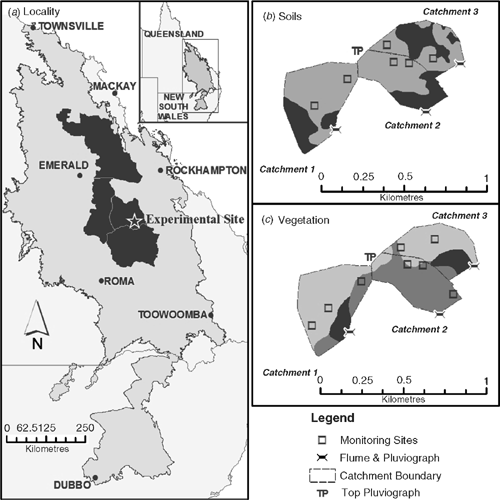
The Study site is located at 24.81°S, 149.80°E using the Geocentric Datum of Australia 1994 (Australian Government – Geoscience Australia 2007) on the Brigalow Research Station, situated equidistant between Theodore and Moura, south-west of Rockhampton. This area is in the south-eastern section of the northern brigalow bioregion and is representative of the bioregion’s climate (Fig. 1a). The Study site is owned by the Queensland Government and tenured as a ‘Reserve for Experimental Purposes’, which provides security of tenure, access to office, laboratory, and accommodation facilities, farm staff, and an existing public profile.
|
The experimental catchments
The 3 adjacent catchments known as C1, C2, and C3 have contributing areas of 16.8, 11.7, and 12.7 ha, respectively. Topographic (J. Kalnins, pers. comm.), vegetation (R. W. Johnson, pers. comm.), and soil surveys (Hubble 1970; Webb 1971; R. J. Tucker, pers. comm.) confirmed the catchments had similar area, aspect, slope, vegetation composition, and soil characteristics, and are representative of the broader brigalow bioregion. The total experimental area of approximately 45 ha meant that weather variability across the 3 catchments would be minimised.
Climate
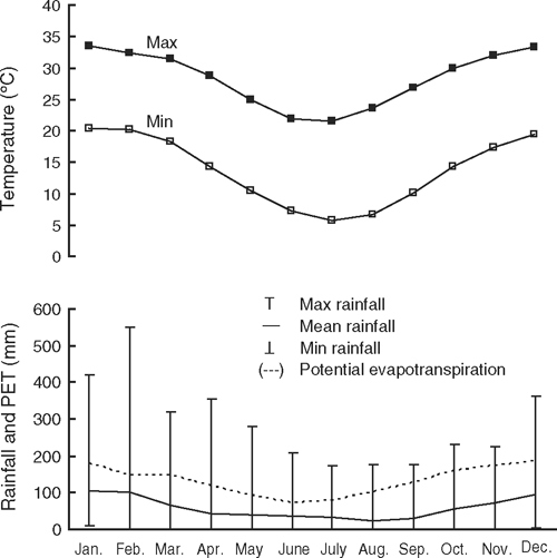
The Study site experiences a semi-arid to subtropical climate. Average maximum monthly temperature (1890–2004) for summer is 33.1°C, while minimum temperature in winter averages 6.5°C. Average annual rainfall is 697 mm with a range of 246–1460 mm. January and February have the highest average rainfall (105 and 100 mm, respectively) and the most variable. Spring and summer (September–February) rainfall is characterised by high-intensity, short-duration storms with high temporal and spatial variability. August is the lowest rainfall month (average 24 mm) and has the least rainfall variability. The 1-hour rainfall intensity with 2-year recurrence interval is 45 mm/h (Institution of Engineers Australia 1987). Average annual evaporation is 2100 mm/year. Average monthly evaporation exceeds average monthly rainfall in all months of the year (Fig. 2), although synoptic conditions can generate occasions when monthly rainfall surpasses evaporation.
|
Geology
The experimental site is located in the south-east corner of the Bowen Basin geological zone on the Mimosa syncline, where isolated remnant tertiary sandstone and conglomerates overlie about 2500 m of the Triassic Moolayember, Clematis, and Rewan sediments of sandstone, siltstone, and conglomerates of marine and non-marine origin (Olgers 1966; Perry 1968). Sandstone from the Rewan formation outcrops in the area and is the likely parent material of soils at the site (R. J. Allen, Geological Survey of Queensland, pers. comm.)
Topography
Altitude at the site is about 155 m above sea level. Land slope within the experimental catchments ranges from 1.8 to 3.5% and averages 2.5%. At the landscape scale, the catchments are part of a plain of moderate relief within the Highworth land system of undulating to nearly flat plains, with depositional slopes ranging from 0.5 to 3.5% and averaging 2.6% (Speck et al. 1968).
The catchments form part of the drainage into Fish Creek, which subsequently provides inflows to Roundstone Creek, before entering the Dawson River. The catchments are located approximately 180 km Adapted Middle Thread Distance (AMTD) from the Dawson River confluence with the Fitzroy River at 275 km AMTD from its mouth.
Soils
Soil types in the experimental catchments comprise associations of uniform fine-textured dark cracking clays (Black and Grey Vertosols), some with gilgais, and non-cracking clays (Black and Grey Dermosols), and subdominant soils of thin-surfaced dark and brown sodic texture-contrast soils (Black and Brown Sodosols) (Isbell 1996, R. J. Tucker, pers. comm.). Vertosols/Dermosols (clay soils) occupy approximately 70% of catchments C1 and C2, and 58% of catchment C3. Sodosols occupy the remaining area in each catchment (Fig. 1b). These soils have a plant-available water capacity ranging from 130 to 200 mm in the surface 1.4 m.
Vegetation
Vegetation at the site is representative of the northern brigalow biome in Queensland. This has structural forms that vary from medium open forest to medium woodland, usually shrubby. Acacia harpophylla (brigalow) is consistently present in the upper storey which can also include Eucalyptus cambageana (blackbutt) and Casuarina cristata (belah) as co-dominant species (Fig. 1c). Geijera parviflora (wilga), Opuntia tomentose (velvet tree pear), Myoporum deserti (ellangowan poison bush), Eremophila mitchellii (false sandalwood), and Carissa ovata (current bush) are present in varying proportions and dominate the shrubby layer. Ground flora consist of a wide range of graminoids, e.g. Cymbopogon refractus (lemon scented barbed wire grass) and Cyperus gracilis (slender sedge), and forbes, e.g. Enchylaena tomentosa (berry cotton bush) and Brunoniella australis (blue trumpet) (Johnson 2004). Projected canopy cover ranges from zero in non-vegetated areas to 100% in tree areas. Litter levels (both leaf and wood) range from 1.9 t/ha in non-vegetated areas to 29 t/ha in tree areas (Dowling et al. 1986).
Experimental rationale
The catchments were chosen as the experimental unit of treatment in preference to small plots or contour bays in order to accommodate the spatial scales of variability that are a feature of these landscapes (Eaton and McDonnell 1989). In addition, measurements of runoff and sediment movement are more representative when conducted at the catchment scale. Treatments (clearing, establishment of commercially realistic land uses) were also more practical to implement, and results after clearing would be more applicable for extrapolation over the broader bioregion since catchments capture common elements of managed landscapes such as contour banks, waterways, cattle paths, camps, and shade lines. Despite the need to capture these spatial interactions, the size of the experimental catchments remained small enough to provide a homogeneous treatment of the areas and monitor with the appropriate intensity. For this reason, a paired-catchment study approach was chosen, given the similarity of area, slope, aspect, climate, soils, and vegetation (Boughton 1970; Brown et al. 2005).
Stage I. Calibration phase (January 1965–March 1982)
The calibration period was designed to capture the runoff responses of the 3 uncleared catchments. This period was expected to be long, given the highly variable climate (Bureau of Meteorology 2006) and the high rainfall seasonality index of 0.39, indicating a marked wet season in summer (Yu 1998).
Stage I rainfall and hydrology data were analysed for the period 1965–79 (Boughton 1985) to characterise the relationship between the 3 catchments and to determine whether the calibration period had adequately sampled the seasonal variability. Catchment C1 had the highest frequency of significant storm runoff events (i.e. >1.5 mm), the highest proportion of rain as runoff, and the highest peak discharges (mm/h). The rationale to retain catchment C1 as the control catchment was based on the fact that any increase in runoff rate from catchments C2 and C3 was less likely to exceed the design of the measurement flumes, and that the distributions of soil types in catchments C2 and C3 were more representative of cropping and grazing lands, respectively. In addition, catchments C2 and C3 were adjacent and logistically easier to clear and subsequently manage.
Stage II. Land development phase (March 1982–September 1984)
The best local practice for clearing brigalow scrub (pulling and burning in situ) was used in line with the philosophy of maintaining relevance of project findings to the broader brigalow bioregion. Although the longer term objective was to monitor the impacts of the replacement land uses during Stage III, measurements during Stage II presented a short period of conditions that were of hydrological interest because of 2 factors influencing water balance, namely reduced transpiration and increased surface roughness. Rapid changes to resource condition (soil fertility, deep drainage, salinity, perched/shallow water table, and subsurface flow) were also anticipated, which could impact on future productivity, sustainability, and water balance. For these reasons, monitoring of water balance, resource condition, landscape parameters, and productivity continued throughout this transition stage.
Stage III. Land use comparison phase (September 1984–December 2004)
In managing the new land uses, the Study’s governing philosophy was to implement the best local practice. This approach entailed the use of flexible management of cropping and grazing catchments reflecting changing local practice, seasonal conditions, opportunities, and emerging technology. This meant that a summer (sorghum) or winter (wheat) crop would occupy the cropping catchment, while in catchment C3, cattle would be stocked at a rate appropriate for the pasture on offer.
The one exception to the application of ‘best local practice’ philosophy was that no fertiliser was applied to crops or pasture. This allowed soil fertility run-down processes to be measured, catering for a significant knowledge gap in the time for nutrient run-down in these brigalow soils.
Experimental methods
Resource mapping—soil and vegetation
Prior to the commencement of the study and in the years before clearing catchments C2 and C3, a range of resource condition assessments and mapping exercises were conducted. These included high resolution soil surveys (Hubble 1970; Webb 1971; R. J. Tucker, pers. comm.), a vegetation survey of the Brigalow Research Station (Johnson 2004), and additional vegetation descriptions at selected monitoring sites within the catchments coinciding with soil survey locations used by Tucker in 1981 (R. W. Johnson, pers. comm.), which recorded canopy species, percentage canopy cover, canopy closure, understorey and ground species, and ground cover.
Land clearing and transition to new use
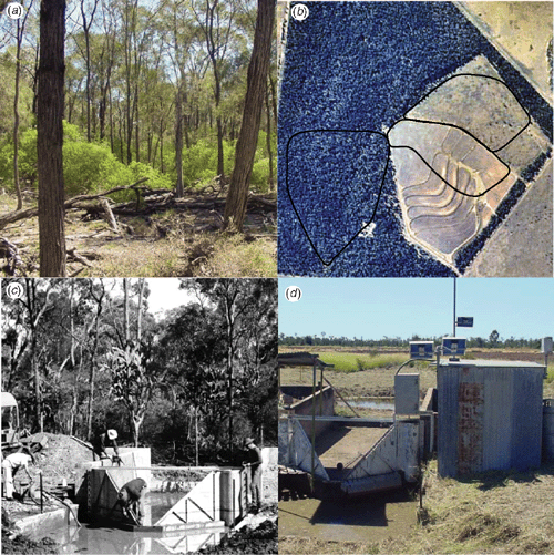
The process of clearing catchments C2 and C3 commenced in March 1982 using 2 bulldozers drawing a chain to fell timber. The fallen timber was allowed to dry before burning in situ in October 1982. In catchment C2, residual unburnt timber was raked to a contour line, burnt, and then covered by graded narrow-based contour banks (0.3% channel slope) at 1.5-m vertical intervals. A grassed waterway was constructed at the same time and sown to Bothriochloa pertusa grass to provide protection against erosion. The grassed waterway occupies <0.5 ha of the catchment. In preparing catchment C3, the unburnt timber was left and the catchment was sown to Cenchrus ciliaris L. cv. Biloela (buffel grass) (Integrated Botanical Information System 2005) in November 1982. Advantage was taken of an ‘ash bed effect’, where fresh ash provides an ideal environment for seed germination, and young plants can capitalise on the flush of plant nutrients from burning. The pasture was allowed to establish and develop before introducing cattle from December 1983. Catchment C3 has one watering point but no contour banks. The cleared area (C2, C3, and a cropped area adjacent to C2) was enclosed by a fence (1.8 m high) to prevent access by wallabies, kangaroos, and feral animals (hares and wild pigs). The grazed area was also fenced off from the cropped area. The control catchment C1 remained undisturbed throughout this time. Figure 3a shows a typical virgin brigalow–belah vegetation association. Figure 3b shows the location of the experimental catchments with the new land use treatments imposed.
|
Management of land use treatments
Cropping catchment
When the waterway was established and contour banks constructed, the first crop was planted to sorghum in September 1984. Subsequent crops were planted to wheat during winter each year until 1994 (except 1993), after which opportunity or response cropping of wheat and sorghum was adopted. Opportunity cropping is defined as the planting of crops whenever soil water and planting rains permit, in contrast to a fixed rotation (Freebairn et al. 2006). This placed a greater focus on water balance while maximising crop production over time.
Fallow management in the early period of Stage III comprised disc tillage followed by chisel and scarifier operations. With time, tillage frequency was reduced. Herbicides were first used to replace tillage for weed control in 1987. After 1990 a philosophy of minimum tillage, which included long periods of zero tillage, was adopted.
Grazing catchment
The total area accessible to grazing cattle is 17 ha. Of this, 0.5 ha is uncleared brigalow scrub which functions as a shade refuge for the cattle. The remaining 16.5 ha is occupied by sown buffel pasture, of which 12.7 ha contributes to catchment runoff.
To maintain pasture dry matter levels at no less than 1 t/ha, stocking rates have varied between 0.29 and 0.71 head/ha (5 and 12 animals each typically 0.8 adult equivalent), depending on animal age and seasonal conditions. During the 21 years of measurement, average stocking rate was 0.48 head/ha (approximately 8.2 animals). There has been no feed supplementation and no fertiliser application. The limited regrowth of brigalow, understorey shrubby species, and herbaceous ground cover has not warranted control to date.
Brigalow scrub catchment
Human activity within the brigalow scrub catchment has been minimised to maintain its natural functioning and water balance. Vehicular traffic has been limited to soil sampling visits. No cattle grazing has occurred. The scrub catchment adjoins 300 ha of remnant ungrazed brigalow scrub which buffers the catchment area against changes due to habitat fragmentation and isolation (Laurance and Yensen 1991; Saunders et al. 1991). An increasing population of black-striped wallabies has harboured in the catchment following the planting of Leucaena leucocephala pastures in an adjacent paddock in 1996. Their population was restricted in 1999 after the partial fencing of the catchment in accord with their natural home range (Evans 1996).
Monitoring methods
Water balance
Rainfall and evaporation. To capture the local variability of rainfall during Stage I, a network of three 0.5-mm tipping- bucket rain gauges recording to charts covered the site. The record from the head point of the catchments (TP in Fig. 1b) was the only site regarded as being reliable (Boughton 1985). At the commencement of Stage II, these gauges were replaced by four 203-mm-diameter Rimco 0.5-mm tipping bucket rain gauges fitted with data loggers. Three rain gauges were sited at the discharge point of each catchment and one at the head point of all three.
Pan evaporation and temperature data are available from the Bureau of Meteorology station (No. 035149) 2 km to the south.
Runoff. For the duration of the study, runoff from each catchment has been directed through a 1.2-m HL flume fitted with a stage height recorder. Each flume has a concrete approach box 3.9 m by 6.1 m, and earth wing walls (Brakenseik et al. 1979). Figure 3c and d show a measurement flume under construction and the present recording infrastructure.
Soil water. Soil water measurements commenced in 1981 before clearing and were repeated on a monthly or 2-monthly sequence until 1990, and thereafter 3 times per year, typically at planting, anthesis, and harvest of crops in catchment C2. Soil water in the surface (0–0.2 m in 0.1-m increments) was measured gravimetrically by compositing 8 cores from each permanent monitoring site. The data were converted to a volumetric basis using measured soil bulk densities. Soil water in the profile (0.2–2.0 m or rock interference in 0.2-m increments) was monitored by neutron scatter technique at 4 permanent locations in each of the permanent monitoring sites. Neutron counts were converted to volumetric moisture using a calibration based on volumetric samples from the site.
Shallow water table and subsurface flow. Late in Stage I, 6 pairs of piezometers were installed in each catchment to monitor shallow or perched water tables and estimate lateral flow within the catchments. Pairs were positioned in lower-slope positions and at positions where topography and soil type transitions favoured groundwater accumulation. One tube of each pair monitors water head at 2 m, the other at 7.5 m or bedrock, whichever is the lesser depth.
Ground water. A groundwater observational bore (13030825) installed in catchment C2 intercepts the water table at 39 m and maintains a head ~19 m below ground surface. Ground water levels have been monitored using a data logger since 2003.
Resource condition
Soil sampling. Three permanent monitoring sites were established in each catchment using double stratification with random sampling to monitor changes in soil properties. Initial stratification was based on soil type and slope position with a monitoring site in an upper and lower-slope position on clay soil, and the third on a Sodosol soil. Each site measures 20 by 20 m. Secondary stratification was by way of 10 sub-units within each site.
Surface soil (0–0.1 m) samples were a composite of 8 (20 pre-clearing) 50-mm-diameter cores, 2 cores (5 pre-clearing) being taken from around 4 fixed points within each sub-unit. Soil profile (0–2 m or resistance) samples were a composite of five 50-mm-diameter cores, each from a different sub-unit. This approach allowed changes in soil properties to be reliably measured and compared across soil types and catchments and be aggregated or disaggregated to fit the scale of the process of interest (Pickett 1991). More intensive pre-clearing soil sampling provided rigorous benchmark data.
Sampling of surface soil was done annually from 1981 (before clearing) to 1987, then in 1990, 1993, 1997, 2000, and 2003. Soil profile samples were taken biennially from 1981 to 1987 then in 1990, 1993, 1997, 2000, and 2003 at the same time as the surface samples. All soil samples are archived. Some soil physical characteristics were measured (in situ and laboratory) adjacent to each monitoring site in 1991.
Soil properties. A suite of soil properties has been monitored within the 3 permanent monitoring sites in each catchment since 1981. Soil property data include: total and available nutrients, micro nutrients, organic carbon, exchangeable cations, cation exchange capacity, total elements, particle size, dispersion ratio, pH, chloride, and electrical conductivity.
Water quality. Runoff water quality (nutrient and sediment content from all catchments and pesticides from the cropped catchment) has been monitored since the commencement of Stage II. On most occasions, discrete samples have been taken throughout the hydrograph as rising stage samples, pumped samples, or hand ‘grab’ samples. Since 2000, automatic water quality samplers have improved the reliability of collected samples, which have been processed and analysed under the ISO 9001:2000 accredited procedures of NRW.
Soil loss. To estimate soil erosion after significant runoff events, measurements have been made of rill erosion in catchment C2 (using similar methods to Freebairn and Wockner 1986), bed load (from deposited sediment in a 10 by 10 by 1 m pond above each flume) and suspended load in runoff (based on a flow-weighted mean of spot sample load concentrations and runoff volume). Increased attention was paid to measurement of soil loss after 2000.
Productivity. Prior to clearing, the floristic composition of the trees (density, basal area, canopy size, and height) and herbaceous plants (density and basal area) was recorded at each permanent monitoring site using the TRAPS procedure (Back et al. 1999) to assess productivity and status of the brigalow scrub vegetation. After clearing, the location of pulled vegetation on each site was mapped before burning. Photographic records were collected at all monitoring sites before and immediately after clearing and have continued for sites in C1 at varying intervals.
Agronomic measures of crop performance in catchment C2 include crop establishment, dry matter at anthesis, grain yield, and grain protein content. Grain yield has been determined at a range of scales from quadrats in the monitoring sites (6 × 1 m2) to harvest strips near the monitoring sites (6 × 40 m2) to whole-of-catchment yield. Grain samples from 1999 onwards have been archived.
Immediately after burning, the depth and mass of ash, and subsequently pasture establishment, were mapped at the C3 monitoring sites. Pasture productivity has been monitored through assessments of total dry matter, species composition, and species dry matter data over the whole catchment (Tothill et al. 1978) biannually from 1983 to 1991 and in 2003 and 2004. Additionally, 25 wheelpoint transects were taken annually from 1983 to 1987 with basal and aerial projection cover estimates partitioned for type and species. Belt transects (0.5 m wide) recorded the number and height of woody plant species over the catchment. Animal productivity was monitored at 3–4-monthly intervals by weighing fasted cattle in and out of the grazed catchment.
Data management
Given the large amount of data accumulated over 40 years, structured databases are used to assist with data entry, storage, and analysis. Soil description data are stored in the NRW Soil and Land Information (SALI) database (Department of Natural Resources and Water 2007). Rainfall and runoff data are stored using the Kisters HYDSTRA database. Most other data are stored in a custom MS ACCESS® database.
Results
Summary of the data resource
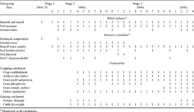
Table 1 provides a summary of the parameters comprising the core dataset and indicates their quality and present availability.
|
Are the catchments good pairs?
Hydrological similarity
The paired-catchment approach where catchments are calibrated before treatment acknowledges that no 2 catchments will have identical rainfall/runoff and water balance relationships. Data on their inherent differences, however, allow adjustments to be made when comparing post-treatment observations. Nevertheless, if paired catchments do have similar runoff indices when untreated, it indicates they have strong similarities in runoff-governing attributes.
A comparison of the hydrological characteristics of the 3 catchments during Stage I (1965–1979) showed little difference in event runoff generation and annual rainfall/runoff relationships. (Boughton 1985; Lawrence 2005). Updated regression equations (Thornton et al. 2007) for the calculation of storm event runoff from catchments C2 and C3 based on the measured runoff from catchment C1 are presented by Eqns 1 and 2, respectively. These equations have intercepts that are not significantly different from zero (P > 0.05); however slopes differ significantly from 1 (P < 0.001):


While Eqns 1 and 2 indicate that before clearing, catchments C2 and C3 have on average 5% and 28% less runoff than C1, these differences are sufficiently predictable to allow comparisons to be made across catchments with concurrent treatment differences, and also within a catchment through time. Thornton et al. (2007) demonstrate that the length of record available allows for several statistical and water balance approaches to be used to determine hydrological responses due to the different land uses.
Soil properties
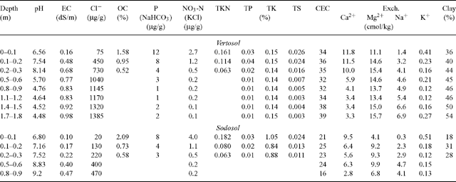
The permanent monitoring sites established on clay soils (Vertosol/Dermosol) in each catchment had very similar physiochemical characteristics. Sodosol soil sites within catchments C1 and C2 are well matched; however, the monitoring site in catchment C3 contains a higher proportion of clay. Table 2 shows the physiochemical characteristics of typical clay and Sodosol soils.
|
Rainfall during the experimental period in long-term perspective
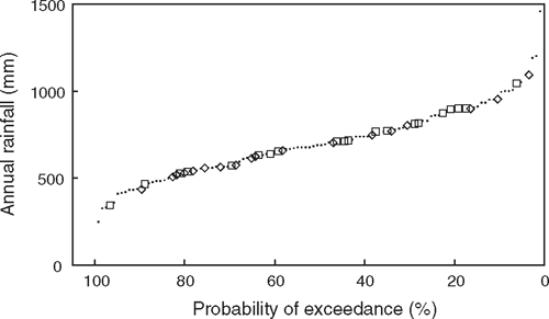
To explore the representativeness of rainfall during the study period requires a comparison with a longer term record. The nearby Bureau of Meteorology station (035149) has a similar period of record to the study; however, the patched point data (SILO database NRM Enhanced Meteorological Datasets 2005) record for this station commences in 1889.
For the period 1889–2004, average annual rainfall was 697 mm per year. A frequency distribution of annual rainfall shows that during the pre-clearing and post-clearing phases of the project, annual rainfall totals encompassed the full range of the long-term record (Fig. 4).
|
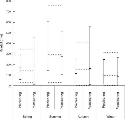
Seasonal rainfall totals during Stage I were less extreme than experienced before 1965 when the Study commenced (Fig. 5). During the post-clearing Stages II and III, seasonal rainfall was greater than the long-term maximum in spring and autumn (Fig. 5). Comparing between experimental phases, seasonal rain was generally similar except for the higher maxima experienced in Stage II in spring and autumn and the lower maximum in summer (Fig. 5).
|
On-site, rainfall during the study period has averaged 648 mm. Average annual rainfall during Stage I (621 mm) was slightly less than during Stage III (656 mm) with fewer wet days annually during Stage I (52) than Stage III (76).
For the period of record at the site (1965–2004), peak rainfall intensity over 1 h with a 2-year recurrence interval was 54 mm/h, and for a 10-min period was 110 mm/h.
Benchmarking the BCS against a range of desirable attributes for long- term studies
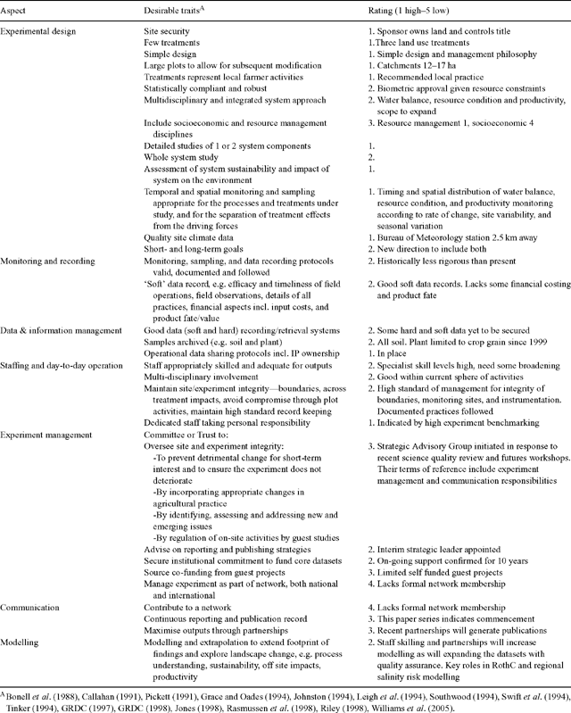
Long-term agricultural and ecological studies throughout the world are under regular scrutiny to justify the continued support of sponsors. Many are managed under the direction of management boards or committees (Leigh et al. 1994). Through such processes and international forums, we have reviewed various assessments to develop a set of criteria that reflects the desirable traits of a rigorous long-term study. The benchmarking of this study against the relevant criteria provides a useful tool to explore the strengths and weaknesses of this, and possibly other, ecological long-term catchment studies (Table 3). This self assessment indicates the Brigalow Catchment Study has been well designed and executed, the original and extended project objectives have been achieved, and there have been moderate levels of peer-reviewed publications and scientific networking.
|
The value, resilience, and success of a long-term study can depend on issues such as higher level experimental management, strategic planning, and communication, as well as aspects of experimental design, procedures, policies, data management, and day-to-day field practices (Pickett 1991; Leigh et al. 1994; Swift et al. 1994; GRDC 1997; Rasmussen et al. 1998; Riley 1998; Crawford et al. 2003).
Key findings on the impacts of clearing
Water balance
Clearing brigalow scrub for cropping or grazed pasture increased the frequency and volume of runoff compared to the natural system (Thornton et al. 2007). Once cleared and the replacement land use established, the annual runoff increased from 5% to 11 and 9% of rainfall for the cropped and grazed catchments, respectively. A high level of confidence in the quantum of runoff increases was achieved through using 4 analytic techniques, each of which show a similar increase in runoff. The pre-clearing catchment calibration phase was critical to 2 of these techniques. The change in runoff may be attributable to a decrease in evapotranspiration associated with annual cropping and winter-dormant pastures, and reduced infiltration associated with exposure, soil compaction, reduced surface roughness, and reduced ground cover (Thornton et al. 2007). Clearing also increased the frequency of runoff events (Thornton et al. 2007), the mean peak rate of storm runoff and time to runoff commencement (Lawrence and Sinclair 1989).
Productivity
High productivity of early pasture and crops is attributed to the flush of available nutrients mineralised by fire and the lack of vegetation during the land development phase (Cowie 1993). Radford et al. (2007) present data showing the productivity of both the cropping and grazing enterprises has declined since establishment of the new land uses. In the cropped catchment, grain yield from 14 winter crops declined significantly in 20 years from 2.9 to 1.1 t/ha.year on the upper slope clay soil (92 kg/ha.year) and from 2.4 to 0.6 t/ha.year on the Sodosol soil (88 kg/ha.year). Crop production per year declined by 20% between 2 successive 10-year periods. Wheat grain protein content also declined with time, falling below the critical value for adequate soil N supply (11.5%) only 12 years after clearing in the Sodosol. Declines in grain quantity and quality are attributed largely to poor soil N fertility. Initial pasture availability of 8 t/ha had halved 3 years after clearing, and a decline in cattle liveweight gain of 4 kg/ha.year was observed over an 8-year period with constant stocking of 0.59 head/ha.
Nutrient change and export
Total soil nitrogen (TSN) and soil organic carbon (SOC) in the top 0.1 m declined by 10% (250 kg/ha) and 11% (2.7 t/ha), respectively, with the clearing and burning of native vegetation (Hunter and Cowie 1989). Overall, the mean rates of loss from the top 0.3 m of cropping soil during 21 years were 1004 kg/ha.year for SOC (1.6% of the initial amount per year) and 84 kg/ha.year for TSN (1.9% of the initial amount per year). SOC and TSN levels did not decline significantly in the brigalow scrub or pasture catchments in the long term. The amount of N exported from the cleared catchments was 36.1 kg/ha.year in grain but only 1.6 kg/ha.year in cattle (as liveweight gain) (Radford et al. 2007).
Leaching of chloride and deep drainage
Using a simple transient solute mass balance model and changes in soil chloride levels, Thorburn et al. (1991) found average leaching rates of 7, 70, and 29 mm/year in the brigalow scrub, cropped, and grazed catchments, respectively, over 1.7 years (1.4 years of which was post clearing), but no significant leaching in the subsequent 4.2-year period to November 1987. D. M. Silburn (pers. comm.) found average deep drainage of 25 and 3.7 mm/year for cropped and grazed catchments, respectively, over 19 years since clearing using a similar transient chloride mass balance model approach. Excluding the development phase, drainage was 14 mm/year for the cropped catchment and at near steady-state rates under grazed pasture. Under brigalow scrub, steady-state Cl− mass balance gave deep drainage of 0.13–0.34 mm/year over the entire period. Total Cl− mass removed from the surface 1.5 m since pre-clearing is some 10 and 7 t/ha, equating to a 60 and 27% loss from the cropped and grazed catchments, respectively.
Unanticipated application of long-term data
The historical sample archive from the Brigalow Catchment Study has provided opportunities for applications that were not planned for in the initial design. For example, the soil carbon fractionation measures using historical samples from the monitoring sites were used to calibrate the RothC soil carbon model (Skjemstad et al. 2004) for estimating Australia’s soil carbon emissions. RothC is now a module in the Australian Greenhouse Office FullCAM carbon accounting model for estimating and predicting all biomass, litter, and soil carbon pools in forest and agricultural systems in Australia (Australian Greenhouse Office 2006). At the time of this analysis (2000), the Brigalow Catchment Study was one of only 2 sites nationally with appropriate management history and records, soil sampling protocols, and sample archive in Australia, and is currently the only remaining site available. Historical samples have also been used in the comparison of soil carbon analysis methodology (Skjemstad et al. 2006).
The detailed and long-term dataset from this study make it ideal for use in the calibration and validation of resource process and productivity models such as PERFECT (Littleboy et al. 1992), APSIM (McCown et al. 1996), and Howleaky? (McClymont et al. 2006). Site data have assisted in parameterisation of landscape and catchment salinity risk and water quality models such as 2CSalt (2C Project Team 2005) and SEDNET (Young et al. 2001), directly through the provision of parameter values and indirectly by providing points of truth for scaling values of estimates for material flows. The site has been useful as part of a national reconnaissance survey of soil erosion using the activity of the radioactive isotope caesium-137 (Elliott et al. 1996; Loughran et al. 2004). The BCS assisted in the development of guidelines for LTAEs in Australia (GRDC 1997) and was used as a case study for the assessment of LTAEs in Australia (GRDC 1998). M. L. Stephens (pers. comm.) has used the dataset for a financial assessment of a long-term grazing regime in the brigalow region.
Companion projects
As opportunities arose, the site has been used for projects requiring a quantified benchmark against which to compare treatment impacts on soils that are characterised and representative regionally. Access to archived soil and plant samples has also been available. The cropping catchment was used as a resource to study the impacts on soil structure and subsequent crop performance of cattle grazing crop residues (Radford et al. 1999). Connolly et al. (1997) and Connolly (2000) used the site to study soil hydraulic properties. The cropping area adjoining C2 has hosted studies of fallow management (Lawrence et al. 1994), wheat establishment (Radford et al. 1995), nutrient stratification (Cowie et al. 1996), fertiliser and fallow management interactions (Cowie et al. 1995), and soil mixing (Asghar et al. 1996). A nearby study of soil changes accompanying land development (SCALD) where land was cleared in 1975 provides a comparable soil fertility dataset. These studies formed part of a network of research, development, and extension activities to advance understanding of water balance, soil erosion, and the adoption of conservative farming practices in Queensland (Thomas et al. 2007).
Other studies conducted on the Research Station bring data richness beyond the BCS’s core dataset. They include seasonal inventories of fauna (bird, mammal, reptiles, insects, and amphibians) (Jeffery and Whitby 1999, 2000; White et al. 2002a), a bird survey (Jeffery et al. 1998), studies of black-striped wallaby feeding and habitat utilisation, management, and their utilisation of remnant vegetation and adjacent pastures (White et al. 2002b, 2004; White 2004), an insect survey which found the rare wingless dung beetle (Onthophagus apterus) (Monteith and Cook 2002), a cicada (Hemiptera) survey finding a new undescribed brigalow species (Ewart 2004), a preliminary study of soil carbon change under good quality buffel grass pasture (Gifford and Burrows 1999), studies of surface soil physical and chemical characteristics related to vegetation canopy cover (Dowling et al. 1986), the regeneration of a brigalow vegetation community, and the long-term monitoring of changes in brigalow vegetation over time (Johnson 2004).
Discussion
The scientific niche occupied by long-term studies is their ability to deliver planned and unexpected findings on subtle, slow, and complex processes, and rare events that may or may not be responses to anthropogenic factors (Pickett 1991). In this context, the Brigalow Catchment Study occupies a niche with respect to its contribution to understanding interactions between climate and water balance, catchment hydrology, nutrient rundown, salinity, and productivity decline for the major land uses in the semi-arid environment of the brigalow bioregion. In addition, its retention of a ‘control’ catchment of virgin ungrazed forest allows for a permanent site to benchmark future samplings and test hypotheses, and its dynamic management of treatments ensures its ongoing industry relevance. The Study’s design and location make its findings relevant to production over a large area that is extensively cleared for agriculture (37 m hectares of the brigalow bioregion). The breadth and depth of the available datasets should contribute to studies of interactions between hydrology, production, resource condition, and sustainability in any semi-arid tropical environment. The site’s history makes it a valuable physical resource where other disciplines and organisations can add value to the existing data, the archived samples and the accumulated land use history.
Future directions and arrangements
Following an independent review and implementation of its recommendations, the Queensland Government through the Department of Natural Resources and Water has established a strategic advisory group charged with managing all aspects of the Brigalow Catchment Study. This indicates a commitment by the sponsor to the Study’s continuation, its scientific quality, and contribution to support future resource planning and policy improvement. The establishment of a strategic management board is consistent with the arrangements employed by many long-term studies such as Rothamstead (Johnston 1994), Kellogg Biological Station (Michigan State University 2006), Hubbard Brook Ecosystem Study (National Science Foundation 2006), and Walnut Gulch Experimental Watershed (United States Department of Agriculture 2007).
In considering the future of the study, scientific and industry peers agreed that the land uses within the catchments should be maintained as implemented since 1983 but the management of those land uses should change. The new management regime will aim to improve soil health, productivity, and sustainability in the cropping and grazing catchments while minimising off site impacts. This shift will ensure the study’s findings are relevant to the regional cropping and grazing industries and allow them to be spatially extrapolated with confidence. The implementation of these management actions therefore redefines a new scientific question, namely:
‘Can cropping and grazing of cleared brigalow lands be managed sustainably using commercial practices that provide stable or improved economic performance with minimal off-site impact?’
Other successful long-term studies have shown that research partnerships and collaborations become the norm. The sharing of site data and resources will enhance the breadth and quality of data analysis and interpretation and maximise the scientific and community return from this long-term investment.
Future value of the study
While this present series of papers demonstrates that the study has met its initial aims, we recognise that there are fields of data as yet unexplored (such as runoff water quality and soil loss) and there is much more richness within the published and unpublished datasets yet to be revealed. For example, the opportunity exists to:
-
Examine land use impacts on seasonality of flows, event characteristics, and water quality;
-
Assess whether larger regional catchments reflect these impacts, and if so how they affect aquatic ecosystems;
-
Compare impacts on water balance and resource condition in C2 during the 10 years of tillage and wheat monoculture with the 10 years of minimum tillage and opportunity cropping;
-
Understand water balance and use patterns of the virgin brigalow vegetation;
-
Model the impact of changing enterprise type (due to market forces) on profitability and resource condition;
-
Identify runoff processes and the relative importance of drivers such as cover, soil water deficit, soil compaction, and rain intensity/quantity;
-
More completely analyse the soil fertility impacts of land use and land use change;
-
Update flood mitigation and erosion control design criteria; and
-
Examine long-term deep drainage estimates based on chloride leaching.
In exploring some of these issues, we can also fill knowledge gaps identified in the literature as deficiencies that limit understanding and modelling of landscape processes. In particular, there is a dearth of knowledge relating to the semi-arid agricultural areas, perhaps because many answers can only come from a few long-term studies which capture the seasonal and annual variability of semi-arid rainfall, which drives most processes.
Knowledge gaps within semi-arid climates relate to:
-
Land use impacts on temporal and spatial salinity processes (Tolmie et al. 2003; Yee Yet and Silburn 2003);
-
Reduction in soil organic matter;
-
Buildup of pollutants in the soil;
-
Changing above- and below-ground ecology (Jones 1998);
-
The role of rare and episodic events (Pickett 1991);
-
Resource accounting (Australian Science and Technology Council 1996);
-
Soil nitrous oxide emissions (Australian Greenhouse Office 2006); and
-
The prevailing gap between production intensification and environmental protection (Jones 1998);
Several knowledge gaps in the hydrological area can be addressed by the BCS. They include:
-
The long-term hydrological impacts of land use change expressed on average, temporally, and spatially with changing climate;
-
Impacts on sub-annual (seasonal and monthly) runoff expressed empirically and as flow duration curves (FDC);
-
Impacts on flow characteristics such as peak and minimum height and frequency; and
-
Understanding of the physiographic controls on FDCs through compilation with other data from a large number of catchments (Brown et al. 2005).
Implicit in this are knowledge gaps in annual and seasonal soil water storage and water use characteristics of agricultural enterprises, the separation of land use impacts from climate variability impacts, and the validity of extrapolating site data to larger catchments and the regional scale.
The BCS data can also fill knowledge gaps in the field of runoff water quality, for both the nutrient and soil components. On-site productivity and sustainability implications can be examined and also off-site stream health and water quality impacts on the Great Barrier Reef. The demand for knowledge to support modelling is increasing as modelling tools evolve in complexity of input and output. Regional natural resource management bodies have been chartered with the responsibility of facilitating change within their catchments (Department of Environment and Heritage 2006) and are using modelling tools such as Sednet (Young et al. 2001; Wilkinson et al. 2004) and EMSS (Chiew et al. 2002). The aims are to deliver agreed environmental outcomes to benefit the community, river health, and the Great Barrier Reef. The BCS can provide validation of model sub-components and a point of truth in such activities.
Unforeseen benefits and discoveries are a common outcome of long-term studies (Pickett 1991; Rasmussen et al. 1998). Emerging global issues may well benefit from BCS data and its soil archive in the future. Such issues include greenhouse gas emissions (e.g. nitrous oxide) (Australian Greenhouse Office 2006) and climate change impacts including impacts on hydrology (Greb 2006).
While the Study’s lack of treatment replication may be considered an experimental weakness, compensating factors include the careful selection of the experimental site to be representative of the broader region, the robustness of the Stage I calibration due to its 17-year duration, the duration of the Stage III land use comparison, and the use of a stratified random sampling design for monitoring soil fertility changes. In reality, few paired-catchment studies have replicated treatments (Brown et al. 2005). The long-term record constitutes a model in its own right. Confidence in findings from an unreplicated long-term study can be gained through subsequent monitoring of selected variables at a series of carefully chosen, spatially distributed sites (Pace and Cole 1989; Tinker 1994). Such an approach provides spatial validation of study findings. It can also add specific quantification across time and land classes to process understanding, which is needed to meet current demands in landscape modelling. An example of this approach is a recent project to quantify deep drainage and soil chloride leaching under cropping (as observed in this study) throughout the region to support delivery of a regional salinity risk map (Chamberlain et al. 2007).
What would we do differently?
With the benefit of hindsight, some things could be done differently if this study were to commence today. The catchments should have been calibrated in their virgin condition not only for runoff but also for the natural range in soil water usage, soil fertility, carbon fluxes, rainfall intercept, rainfall stem flow, energy flows, and botanical dynamics. Today we would take a holistic view of land use change, placing more importance on ecosystem services, biodiversity, botanical dynamics, and model parameterisation needs, among others. However the opportunity to research some of these issues is not lost. The site can host many studies if they do not threaten the integrity of the core study.
Conclusions
This study has been no exception to the observation that long-term studies commonly have a poor publication record (Pickett 1991; Grace and Oades 1994; Leigh et al. 1994; Swift et al. 1994). Because they study rare events and subtle, slow, and complex processes, publishable findings from long-term studies can take years to unearth. Such infrequent publication opportunities have led to concerns about career ‘fitness’ and advancement, and contrast with the abundant publication and career benefits that come from higher profile short-term (reactive) science (Pickett 1991). As a result, long-term studies are often held in low esteem by scientists and their management (Leigh et al. 1994). Nevertheless, the publication of findings from long-term studies plays a critical role in the advancement of scientific knowledge for the benefit of society. With a new experimental direction and the building of partnerships, we expect the BCS to prove a sound investment in the scientific research portfolio.
The study has answered many of its original research questions and also provided unanticipated benefits, a common outcome for long-term experiments. There have been unforeseen uses in the areas of hydrological design and model calibration and validation. Samples have been available to test new laboratory methods and provide reference points for processes that manifest over periods exceeding the standard 3–5 years of most field experiments.
Strengths and weaknesses of the BCS were identified by benchmarking it against attributes of good long-term studies, through a review, and from subsequent discussions on its redesign. Despite some shortcomings, the high ratings against recognised traits of successful long-term studies indicate the BCS may well qualify as a classic long-term experiment despite its tender 42-year age. Many existing ‘classic’ long-term studies have weaknesses in their publication history, records of methods, data storage and access, site integrity, and sample archiving (Pickett 1991; GRDC 1998; Crawford et al. 2003). The sponsor’s positive response to addressing weaknesses will further enhance the overall quality and benchmark status of the study.
The BCS began in an era when many think there were more freedoms and less scrutiny within scientific research. While that may or may not be the case, the documentation regarding the commencement of this study and its transition to Stage II indicate debate and scrutiny levels were high. The vision and persistence of scientists and administrators to instigate, then continue, such a long-term study is to be commended. So too is the dedication of many staff who faithfully and accurately maintained treatments and records during periods when labour and funding support were much reduced. As a result we now have an unparalleled data resource that can be considered a model in its own right. It will continue to answer questions we have not yet thought to ask.
Acknowledgments
Many staff have contributed to the design and execution of this study. We thank you H Pauli, J Rosser, A Webb, P Lawrence, R Bryant, A Dowling, H Hunter, N Cocaris, J Kalnins, R Scarborough, R Puschmann, R Gillespie, D Sinclair, B Kitchen, A Key, P Hansen, G Thomas, E Anderson, P Back, D Miles, W Burrows, M Nasser, A Lloyd, A Barnes, M Jeffery, T James, and staff of the NRW Chemistry Centre and the DPI&F Brigalow Research Station. The authors acknowledge input from Dr David Freebairn in his role as Strategic Science leader of the BCS in 2006/07. He was able to carry out this task as part of a Land and Water Australia Senior Research Fellowship.
Brown AE,
Zhang L,
McMahon TA,
Western AW, Vertessy RA
(2005) A review of paired catchment studies for determining changes in water yield resulting from alterations in vegetation. Journal of Hydrology 310, 28–61.
| Crossref | GoogleScholarGoogle Scholar |
[accessed 24/09/2007].
Connolly RD,
Freebairn DM, Bridge BJ
(1997) Change in infiltration characteristics associated with cultivation history of soils in south-eastern Queensland. Australian Journal of Soil Research 35, 1341–1358.
| Crossref | GoogleScholarGoogle Scholar |
[accessed 24/09/2007].
Dowling AJ,
Webb AA, Scanlan JC
(1986) Surface soil chemical and physical patterns in a brigalow-Dawson gum forest, central Queensland. Australian Journal of Ecology 11, 155–162.
| Crossref | GoogleScholarGoogle Scholar |
[accessed 24/09/2007].
Johnson RW
(2004) Vegetation survey of the Brigalow Research Station, Theodore, Queensland. Proceedings of the Royal Society of Queensland 111, 39–61.
[accessed 24/09/2007].
McCown RL,
Hammer GL,
Hargreaves JNG,
Holzworth DP, Freebairn DM
(1996) APSIM: a novel software system for model development, model testing and simulation in agricultural systems research. Agricultural Systems 50, 255–271.
| Crossref | GoogleScholarGoogle Scholar |
[accessed 24/09/2007].
Radford BJ,
Thorburn PJ, Key AJ
(1995) Enhancement of wheat establishment with modified sowing and fallow management techniques. Soil and Tillage Research 36, 73–89.
| Crossref | GoogleScholarGoogle Scholar |
[accessed 24/09/2007].
Yu B
(1998) Rainfall erosivity and its estimation for Australia’s tropics. Australian Journal of Soil Research 36, 143–165.
| Crossref | GoogleScholarGoogle Scholar |

*Parts II and III, Aust. J. Soil Res. 45(7), 496–511; 512–523.