

To B and not B2 – the Australian soil horizon system: history and review
Ben Harms A *
A *
A Department of Environment and Science, Brisbane, Qld, Australia.
Soil Research 61(5) 421-455 https://doi.org/10.1071/SR22154
Submitted: 28 June 2022 Accepted: 3 January 2023 Published: 20 February 2023
© 2023 The Author(s) (or their employer(s)). Published by CSIRO Publishing. This is an open access article distributed under the Creative Commons Attribution-NonCommercial-NoDerivatives 4.0 International License (CC BY-NC-ND)
Abstract
Soil horizon designation plays a key role in the communication of information about soils – hence the need for uniformity, consistency and clarity in the way soil horizons are defined and designated. Since its establishment in the late 19th century, the A-B-C schema for soil horizons has evolved with the realisation that traditional concepts of soil genesis embedded in the original system do not fit the breadth of current knowledge regarding soil development. Along with a more objective approach, there has been progress toward harmonisation, with considerable agreement between the two major international systems: FAO and USDA. Both use an A-E-B-C-R schema for mineral soil horizons, coupled with the prescriptive use of alphabetic suffixes. This schema is now adopted almost universally – Australia alone has retained the once widespread system of numerically designated horizons, first codified in the USA in 1937. The A1-A2-A3-B1-B2-B3-C-D-R schema for mineral horizons can therefore be regarded as the ‘Australian system’. Australia is also unique in the way it designates organic soil horizons. This review summarises the history of soil horizon designation and critically appraises the Australian system. It identifies ambiguity and inconsistency in the definition and allocation of horizons, and demonstrates that soil horizon notation in Australia is convoluted and complex. Pedology in Australia would benefit by aligning with international approaches including a simpler set of objectively defined master horizons, rationalised intergrade horizons and the more rigorous application of alphabetic suffixes. This would improve both the communication of soil profile information and the utility of soil databases.
Keywords: pedogenesis, pedology, soil classification, soil description, soil horizon, soil profile, soil science history, soil survey, solum.
Introduction
Soil horizons are typically the most distinctive visual feature of a soil profile, and are usually obvious in exposures such a soil pit or roadside cutting. Each horizon has attributes such as colour, texture and structure that distinguish it from those lying directly above or beneath. When a pedologist examines a fresh soil profile and begins to describe its morphology, their first task is to mark out the depths where changes in any significant soil property can be observed – the first estimation of soil horizon boundaries. After the morphological attributes of each soil horizon have been described, the task is to designate each horizon by means of a conventional nomenclature.
Soil horizon designations include both letters and numbers. Capital letters are used for the ‘master horizons’ (e.g. A and B) and lowercase letters for suffixes that signify specific features identified in the master horizon (e.g. Ap). Numbers are used in several ways – to indicate vertical subdivisions within a horizon and as prefixes to indicate discontinuities. The Australian soil horizon system also uses numbers as suffixes to form part of the horizon name (e.g. A1 and B2), hence it may be referred to as a ‘numerically designated’ system. The complete horizon name (all letters and numbers) that is written on field sheets is referred to in this paper as the horizon notation. The horizon notation is a summary of the investigator’s interpretation of observed soil properties and allows for the comparison of soil profiles described at different times and in different places. The notation is entered into databases and plays a critical role in the communication of soil profile morphology and the subsequent interrogation of databases.
Soils are derived from both mineral and organic material. Horizons dominated by the mineral component are the mineral soil horizons (e.g. A, B and C) and those dominated by organic materials are organic soil horizons (e.g. O for partially decomposed organic litter and P or H for peaty material formed in wet conditions). The pedologic soil profile is the thin upper portion of an often much thicker weathering profile beneath – the lower portion mostly being the domain of geologists and regolith1 scientists.
Originally soil horizons were used purely for descriptive labelling purposes (i.e. ‘morphological’ horizons), but were soon being used to interpret or infer pedogenesis (i.e. the soil-forming processes occurring in a soil profile), and hence became known as pedogenetic, or simply ‘genetic’ soil horizons. The nature of the horizons and their vertical sequence in a soil profile were considered to be the expression of particular soil-forming models.
Later, it became necessary to prescribe diagnostic soil horizons (e.g. ‘ferric horizon’, containing >20% ferruginous nodules or concretions) and diagnostic materials, which are quantitatively defined for the purposes of soil classification (e.g. Isbell and National Committee on Soil and Terrain 2021; IUSS Working Group WRB 2022). Although they often correspond, morphological and diagnostic horizons may not coincide exactly in many soil profiles. In this paper, it is the morphological (or genetic) soil horizons used in soil profile description that are reviewed, not the diagnostic horizons of soil classification systems.
In Australia, a soil horizon is defined as ‘a layer of soil, approximately parallel to the land surface, with morphological properties different from the layers below and/or above it’ (McDonald and Isbell 2009), and the term is applied to all layers in a soil profile, as well as the bedrock below. It is commonly suggested (e.g. Soil Science Division Staff 2017) that the term horizon should be used only for layers where some of its properties are produced by ‘soil-forming factors’, but this can lead to confusion, especially with surface organic horizons and layers in the lower part of the soil profile. In some cases, a single master horizon designation does not adequately convey information about the layer, such as where one horizon gradually transitions into an adjacent horizon. If the transitional zone is large enough, it may be delineated as a ‘transitional horizon’ and signified by double-letters (e.g. AB) to indicate both contributing master horizons. Uniquely in the Australian system, transitional horizons are also signified by numeric suffixes (as in A3, B1 and B3). A single horizon may sometimes contain distinct parts from two different horizons – this is called a ‘combination horizon’ and is signified for example as B/C.
While an internationally standardised set of soil horizon designations has not yet been agreed to, there has been gradual progress toward the alignment of horizon designations and nomenclature (Monger et al. 2014). In terms of mineral soil horizons, there is general agreement between the two major international systems: FAO Guidelines for soil description (Food and Agriculture Organization, FAO 2006) and the USDA Soil survey manual (Soil Science Division Staff 2017).2 The A-E-B-C-R schema employed in both was formalised by the FAO in 1974 and the USDA in 1982, and has since been adopted almost universally by national soil survey organisations. There is less harmonisation in designating organic soil horizons.
Over time, there has been an increased emphasis on the use of alphabetic suffixes to indicate specific morphological features, based on objective criteria, and there is also considerable correlation in the set of alphabetic suffixes used (e.g. ‘k’ for the presence of carbonate and ‘t’ for accumulation of clay).
The Australian soil and land survey field handbook (first edition, McDonald et al. 1984; hereafter this publication and its subsequent editions are referred to as the ‘Handbook’) adopted the A1-A2-A3-B1-B2-B3-C-D-R horizon schema for mineral soil horizons first codified in the USA (Kellogg 1937), albeit with a modified D horizon concept. This schema is no longer used anywhere else. The Handbook also implemented a unique schema for organic soil horizons (O1-O2-P1-P2).
Lack of correlation with international systems is one consideration. However, this review also highlights both conceptual and definitional problems with soil horizons as prescribed by the Handbook. Young soil scientists providing feedback for a review of the Handbook have remarked: ‘the definitions incorporate a lot of implied knowledge and unwritten rules and conventions about what and when to call things’.
To understand the Australian soil horizon system and its development, this review explores the history of soil horizon concepts and designations, and how they have been used and adopted in Australia. It critically appraises the Australian system in terms of design, definition and application and makes recommendations for change. In this review, the soil profile is not considered sequentially from the top down; but rather soil horizon concepts are considered in turn, based on an assessment of their degree of importance, and with a logical conceptual flow. Topics include the following:
-
the limitations of traditional soil horizon concepts
-
the legacy of genetic inferences
-
re-evaluating the E horizon
-
B horizon concepts
-
soil horizon notation and the application of alphabetic suffixes
-
transitional horizons – inconsistency and redundancy
-
C and D horizons – issues of definition and inconsistency in application
-
organic horizons (O and P) – providing greater clarity
-
surface soil horizons (A or A1) – evaluating the concept and expanding options for categorisation.
Not included in this review is a detailed evaluation of the set of alphabetic soil horizon suffixes used in Australia. A comprehensive guide to the practical implementation and adoption of a revised soil horizon system is outside of the scope of this review.
Development of soil horizon concepts and designations
In his pioneering work, Vasily Dokuchaev in 1879 and 1883 described an A-B-C schema for soil layers in the Chernozems of the Russian/Ukrainian steppe (Tandarich et al. 2002), an example of which is illustrated in Fig. 1. Dokuchaev synthesised and expanded concepts advanced by others including Albert Orth, Pieter Müller and Charles Darwin. Orth, a German agricultural geologist, published soil maps in the 1870s on the ‘whole soil profile’ down to parent material (Mückenhausen 1997). In 1878 Müller, a Danish forester studying humus in soil profiles, was using the letters a, b and c in profile diagrams (Tandarich et al. 2002). Concurrently, Charles Darwin researching the role of earthworms in soil formation, described and illustrated an A-B-C-D sequence of layers: A for ‘turf sod’, B for the main soil (which he called ‘vegetable mould’), C for a stoneline and D for subsoil (‘black peaty sand with quartz pebbles’) (Darwin 1881). Only later, in 1900, did Dokuchaev first use the term ‘horizon’ for horizontal layers in a soil and at the same time included an undefined D layer for ‘below C’ (Tandarich et al. 2002).

|
The great contribution of Dokuchaev and his Russian colleagues was to introduce the concept of soil as a natural body with a definite genesis, founding what is now known as the science of pedology. They recognised a set of soil-forming factors (e.g. climate, living matter, topography, parent material and time) that acted on parent rock, the expression of which could be seen in the morphology of soils. This led to the notion that the A-B-C soil layers were genetically related to each other. However, adapting the A-B-C layers to soil types other than Chernozems and developing clear genetic concepts for each layer took considerable time (see Table 1). Note that the B layer in the Chernozem is weakly developed – Dokuchaev called it a ‘transitional zone’ (which today could be designated as AC).

|
In 1895, Nikolay Sibirtsev (Dokuchaev’s pupil/colleague) summarised his theory of genetic soil classification, and in 1898 applied these principles in a survey of the main soil types of Russia. An abbreviated translation of each was published in the USA (Sibirtsev 1901a, 1901b). These documents introduced the concept of ‘zonal soils’, in which differences in parent material and lithology are largely masked by the overriding effects of climate and biological factors, which produce relatively uniform soils related to ‘physico-geographical’ zones.
Another major influence of the ‘Russian school’ came via Konstantin Glinka’s treatise on the formation, classification and distribution of soils (Glinka 1914), which was translated from the German by Curtis Marbut, then Director of the USDA Soil Survey Division. Marbut credited Glinka’s work for his ‘discovery of the soil profile’ and communicated aspects of it in various forums (e.g. Marbut 1922) before its official publication in English (Glinka 1927). From the mid-1920s, soil reports in the USA began using soil horizon designations in the ‘Glinka scheme’, which now included numerical subscripts for subdivisions (see Table 1). The A2 horizon was described as ‘being strongly leached’ and B horizons as zones of ‘illuvial accumulation’. In describing Podsols, Veatch (1925) introduced an A0 horizon for organic accumulation and labelled zones of maximum eluviation and accumulation (see Fig. 2). An early soil profile description using a modified Glinka horizon scheme was made by USA soil scientist Charles Shaw reporting on a visit to Australia (Shaw 1925), for what he considered to be a ‘fairly typical’ soil profile (see Table 2). Shaw later chaired a USA committee which consolidated definitions for soil profile, layer and horizon (Shaw 1927).

|

|
Marbut advocated for the description of soils in terms of their inherent soil properties (Paton and Humphreys 2007) and that their classification be based on morphology instead of soil genetic theories, because such theories are both ephemeral and dynamic (Soil Survey Division Staff 2017). Both Glinka and Marbut argued against the term ‘zonal soil’, because it was a geographical rather than a pedologic term (Paton and Humphreys 2007).
Following Marbut, Charles Kellogg assumed responsibility for soil survey in the USA. He produced the first USDA Soil survey manual (Kellogg 1937), with updated soil horizon definitions. Also included was a detailed diagram of a soil profile (see Fig. 3), that showed the horizons in ‘their genetic positions with respect to one another’, including transitional horizons, as per the Podsol sketch of Veatch (1925). Numerical subscripts were now part of the horizon name and carried specific genetic connotations. For example, the A2 was for a horizon ‘impoverished of colloids and bases through such a process as podzolisation’. The B2 was for the zone of ‘maximum illuvial accumulation’. Some alphabetic horizon subscripts were also introduced.

|
Kellogg (1937) also set about (re)entrenching the concept of the soil profile (and solum) as a genetic entity:
-
‘The soil horizons are genetically related to one another and are produced through the action of soil-building forces’
-
‘Taken together, the A and B horizons are referred to as the ‘solum’ which represents the true soil, produced by soil-building processes from weathered material and in which biological activities take place’.
According to Kellogg (1937), the use of A-B-C horizon nomenclature was only possible where the genetic status of a particular horizon was known. In cases of doubt, the horizons were to be simply numbered sequentially from the surface. For young soils, laboratory investigations were advised so that the correct nomenclature ‘could be used with certainty’.
The horizon definitions of Kellogg (1937) were refined in the second edition of the USDA Soil survey manual (Soil Survey Staff 1951) – see the notations in Fig. 3. The principal divisions of a soil profile were now described as ‘master horizons’, while divisions signified by numeric subscripts (A1, A2, A3, B1, B2 and B3) were ‘subhorizons’. Additional alphabetic subscripts (e.g. ‘p’ for ploughing and ‘t’ for clay accumulation) were prescribed to ‘indicate processes active within a horizon’, bringing the total to 14, including ‘u’ for ‘unconformity’ and ‘b’ for buried horizon. However, application of alphabetic subscripts was optional and the numeric subscripts with their specific genetic connotations remained the fundamental part of the schema. Curiously at around the same time, soil scientists in the USSR settled on a very similar set of soil horizon definitions with identical nomenclature, including the D horizon and an additional G horizon for ‘gleying’ and associated anaerobic soil properties (Tiurin 1959, as cited in Bridges 1997).
In the absence of alternative soil description guidelines, many countries modelled their soil survey procedures (including soil horizon designations) on the pattern of the 1951 USDA Soil survey manual, which ‘for many soil surveyors became the last word in all aspects of field pedology’ (Bridges 1997). This was clearly the case in Australia, where copies of the 1951 manual can still be found in government offices more than 70 years later.
As expected, soil horizon designations and nomenclature continued to evolve. In 1962, the USDA released a supplement to the Soil survey manual, dealing specifically with the identification and nomenclature of soil horizons (Soil Survey Staff 1962).3 The main changes follow:
-
an O (organic) horizon was added, along with O1 and O2 subhorizons (to replace the A00 and A0 horizons)
-
the A, B and C horizons were more prescriptively defined
-
the C horizon concept was broadened, and the specifically defined C1 and C2 horizons were removed – numeric suffixes were now to signify any vertical subdivision within the C horizon
-
the D horizon was removed, as it was considered redundant following the above changes to the C horizon
-
the letter R replaced the ‘Dr’ for consolidated bedrock; unconsolidated D horizon materials were now part of the C horizon
-
the G horizon was omitted in favour of the horizon suffix ‘g’
-
numeric and alphabetic horizon suffixes were no longer written as subscripts.
There was also evidence of more objectivity in soil horizon designation with the statement ‘… all distinguishable layers or horizons should be described regardless of genesis … these descriptions need to be completely objective and able to “stand on their own” regardless of presumed genesis’.
In Europe, there was a growing trend to use alphabetic symbols in place of numbers to indicate specific horizon features. Kubiëna (1953) in his Soils of Europe introduced the letter ‘E’ as a subscript (i.e. AE) to indicate a bleached eluvial horizon, replacing the A2. Also introduced were subscripts for different types of organic materials at the soil surface: ‘L’ for fresh plant litter, ‘F’ for partly decomposed and ‘H’ for well decomposed litter.
Meanwhile, the Land and Water Development Division of the Food and Agriculture Organization (FAO), produced its first Guidelines for soil description (FAO 1968). These were a relatively brief guide to encourage uniformity in the presentation of soil information, with a focus on attributes affecting land use. The USDA soil horizon designations (Soil Survey Staff 1962) were repeated verbatim. Later editions of the FAO Guidelines (in 1977, and especially 2006) became widely used references for describing soil profiles.
Concurrently, the International Society of Soil Science (ISSS) set up a working group to review existing soil horizon systems and promote uniformity, which released the first draft of a new system in 1967. A later version was used in the descriptive legend for the FAO-UNESCO Soil Map of the World (FAO-Unesco 1974) and subsequently published in the second edition of the FAO Guidelines for soil description (FAO 1977). The significant new features follow:
-
a reduced set of master horizons (A-E-B-C) for the mineral soil component
-
the E horizon, building on the AE (eluvial) horizon of Kubiëna (1953), replaced the A2 horizon
-
the numerically designated transitional horizons (A3, B1 and B3) were replaced with a revised two-letter schema e.g. AB, AE, EB and BC
-
an H horizon for saturated organic materials – the O horizon was retained for unsaturated organic materials
-
alphabetic horizon suffixes were all single letters (e.g. ‘k’ instead of ‘ca’ for carbonate)
-
additional alphabetic suffixes (e.g. ‘w’ for minor alteration in situ, ‘n’ for accumulation of sodium and ‘s’ for accumulation of sesquioxides).
Since a key feature of the new system was the removal of numbers from horizon names, the use of alphabetic horizon suffixes in combination with master horizon designations became entrenched. By implication:
-
alphabetic horizon suffixes were considered to be more informative and useful compared to numeric suffixes
-
more emphasis was now placed on an objective assessment of significant morphological attributes.
The new system (FAO 1977) included a ‘u’ suffix to be used when a horizon that was not ‘qualified’ by another suffix, needed to be subdivided vertically (e.g. Au1, Au2, Bu1 and Bu2). The ‘u’ for ‘unspecified’ was to avoid confusion with the former notations (A1, A2, A3, B1, B2 and B3).
In 1982, the USDA dramatically switched from its 1951 soil horizon system and adopted the FAO-Unesco initiatives. The notable exception was the H organic horizon, although new suffixes (‘a’, ‘e’ and ‘i’) were introduced to signify different degrees of decomposition of organic materials. Notification of this revision was published as a letter to the editor of the Soil Science Society of America Journal (Guthrie and Witty 1982) and later formalised in the fourth edition of Soil taxonomy (Soil Survey Staff 1990) and the third edition of the USDA Soil survey manual (Soil Survey Division Staff 1993). Guthrie and Witty provided only a very brief justification for the changes: ‘definitions are modified to conform as closely as possible to other systems that are commonly referenced internationally’. Since 1982, the USDA have added three new master horizons – the ‘L’, ‘M’ and ‘W’ layers/horizons. Fig. 4 summarises the evolution of soil horizon nomenclature in the USA, contrasted with the static schema used in Australia.

|
The current FAO Guidelines for soil description (FAO 2006)4 recognise 10 master horizons and layers, which are summarised in Table 3, along with comparisons to the current USDA and Australian systems. A feature of the more recent soil horizon systems is a significant increase in the number of alphabetic horizon suffixes available. In the 1951 USDA system, there were 12 morphological properties captured by suffixes. This grew to 15 in the 1977 FAO system and 21 in the 1982 USDA system. The 2017 USDA system has 28 and the 2006 FAO system has 30 alphabetic suffixes available. According to Bridges (1997) this trend represents a ‘prescriptive phase’ in the evolution of soil horizon systems, as designations are prescribed for horizons, based on strict criteria.

|
Table 3 does not capture the various additional horizons that are used by some national soil survey organisations, including the D horizon in Australia. South Africa has retained the G (gley) horizon from the original USDA 1951 system (Soil Classification Working Group South Africa 1991). Russia also has a gleyic horizon, as well as several other horizons such as a V horizon for strong vertic properties and an F (nodular) horizon (Gerasimova 2001).
The A-E-B-C-R schema for mineral soil horizons, supplemented with the prescriptive use of alphabetic suffixes, first adopted by FAO-Unesco (1974) and also Hodgson (1974) for England and Wales, has now been implemented almost universally by national soil survey organisations. New Zealand changed from the earlier USDA schema in 1978 (Clayden and Hewitt 1988) and has since formulated an expanded set of horizon suffixes and conventions (Clayden and Hewitt 1994). South Africa switched to the new schema in the second edition of its soil classification system (Soil Classification Working Group South Africa 1991). Australia stands alone in its retention of the original USDA horizon schema.
Some limitations of traditional soil horizon concepts
The USDA Soil survey manual of 1951 conceded that the ‘present horizon definitions’ having been adapted from their use in Europe for podzolic soils, may not be ‘entirely adequate’ for many soils (e.g. tundra and desert soils), and foreshadowed that ‘further improvements may be hoped for’ (Soil Survey Staff 1951). To be sure, there are difficulties in applying traditional soil horizon concepts in many landscapes. The original notion of soil horizons forming uniformly in one special set of soil-forming conditions dominated by vertical translocation is most easily demonstrated in youthful landscapes, especially those affected by Pleistocene glaciation. In older landscapes, especially in tropical and arid regions, evidence for eluviation and subsequent illuvial accumulation is not always clear. Brewer (1968), in examining 10 Australian soil profiles with a strong texture-contrast between the A and B horizons, demonstrated that illuviated clay contributed an insignificant proportion of the clay in the B horizons. He postulated that other processes such as differential weathering between the A and B horizons, and sedimentary layering, have caused the particle size differentiation observed. The abrupt texture-contrast commonly found in Australian soil profiles is also sometimes difficult to reconcile with traditional soil-forming concepts.
The original concept of a progressive ‘pathway’ of soil profile development toward a ‘mature’ stable state over specified periods of time may not always hold true. It has been shown that the profile morphology of many soils demonstrates regressive pedogenic processes, called ‘haploidisation’ by Johnson and Watson-Stegner (1987). Haploidisation promotes isotropy, leading to a ‘simplification’ of the profile that blurs horizon boundaries, mixes horizons and may result in remnants of horizons remaining as broken horizons (Hartemink et al. 2020). Regressive processes include pedoturbation, melanisation, nutrient cycling, high water tables, erosion and surface removal; and to some extent these processes occur in all soil profiles (Johnson and Watson-Stegner 1987).
Traditional models of soil formation and horizon development have underestimated the effects of bioturbation and soil creep (Paton et al. 1995). Although not using the term ‘bioturbation’, Charles Darwin (1881) detailed the vital role played by earthworms in churning the soil and depositing casts of finer mineral material at the surface.5 Numerous workers have shown that termites play the same role in the tropics, although estimates of the rate of soil turnover vary (Lobry de Bruyn and Conacher 1990; Wilkinson et al. 2009). Bioturbation may homogenise the soil profile, but in other situations can lead to horizonation, including the development of texture-contrast profiles when combined with particle sorting by rainwash processes (Wilkinson and Humphreys 2005).
A soil profile in inland north Queensland where the soil mantle extends many metres below the surface is shown in Fig. 5. This profile demonstrates haploidisation – horizons are indistinct, there is very little colour change, virtually no pedological structure, and diffuse variation in field texture and clay content (25% at the surface grading to 50% at 0.60 m, then decreasing to 43% at 4 m). There is no evidence of clay illuviation in terms of clay coatings (cutans) and virtually none by micromorphology (Isbell and Smith 1976). The allocation of traditional soil horizon boundaries in this soil is clearly subjective. Such soils seem to have formed in the remnants of old deeply-weathered surfaces; the strong leaching evident in the chemical and clay mineralogy data indicates they are relict – having formed in an environment much wetter than that of today. In addition, the soil surface here is dotted with the mounds of termites, which have been shown to play a significant role in the pedogenesis of these soils (Holt et al. 1980; Coventry et al. 1988). Tropical biomantles built up by termite activity may exceed 100 m in stable tropical environments (Johnson et al. 2005).

|
Another common feature of soils in tropical regions is the occurrence of bands of gravel and stone (stonelines) at shallow to moderate depths, especially in upper slope positions in areas of highly siliceous lithology (see Fig. 6). Such profiles were described by early soil surveyors in Africa (e.g. Nye 1954; Watson 1964) and have been described in northern Australia by Williams (1968, 2019). Nye and Watson used an alternative three-tiered soil horizon model to better characterise the morphology of these profiles: ’M‘ for mineral biomantle, ’S‘ for stony layer and ’W‘ for the weathered rock zone beneath. Bioturbation by termites, soil creep by sheetwash and subsurface lateral eluviation have been postulated to explain the M horizon, which subsequently buries the stone that had previously been at the surface (Watson 1964; Williams 2019). The W horizon is formed in situ. Such three-tiered soils are polygenetic – the M materials are not genetically related to the subsoil W layers directly below. Polygenetic soil profiles are common in Australia, which has been exposed to many cycles of weathering, soil formation and destruction (Butler 1967). Mücher and Coventry (1993), in studying a grey earth (Kandosol) profile in Queensland, found five successive sedimentary layers and three superimposed soil profiles.

|
The examples above show that the formation and development of many soils reflects different or multiple pathways, and their genesis may be complex or unknown. Hence the original ‘one-dimensional’ concept of an eluvial A (or E) horizon over an illuvial B horizon is a gross oversimplification.
To address the ‘very unsatisfactory A-B-C designations’ and the subjectivity of existing horizon systems, Fitzpatrick (1967) broke with tradition and formulated an alternative approach. His scheme categorised all major horizons into 77 named types based on recognisable characteristics, analytical diagnostics and micromorphology. Such a system has precision and is useful for analytical and modelling purposes, but is difficult to remember and apply in the field, especially if not all the analytical diagnostics are available.
Development of soil horizon designations in Australia
The Russian concepts of genetic soil horizons and soil classification (including Sibirtsev’s concept of zonal soils) were introduced to Australia in the late 1920s by James Prescott, who had spent the early part of his career in the United Kingdom and the Middle East (Ward 2011). In the latter part of his career, Prescott travelled to the USSR to investigate the history of the Imperial Free Economic Society, which had sponsored Dokuchaev’s exploratory soil research in the previous century (Prescott 1977). Prescott’s (1931) soil map of Australia showed 10 major soil zones largely influenced by vegetation and climate (as per Sibirtsev 1901b). In the accompanying report (Prescott 1931), a typical soil profile for each soil group was summarised in terms of A1, A2, B1, B2, C and transitional horizons (e.g. AB and BC) – an adaptation of the soil horizon schema of Glinka and Marbut.
Prescott, in his role as head of soils at the Council for Scientific and Industrial Research (CSIR), instigated the first modern soil surveys in Australia, which focused on the Murray River irrigation areas. In reviewing the development of soil survey and field pedology in Australia, Taylor (1970) stated that from the early days, emphasis was on detailed morphology of the soil profile as the basis for defining soil types, with a strong focus on inferred plant relations. ‘Conformity with American practice was sought, but not zealously’, Taylor declared. Description and sampling details were largely based on field recording sheets used by USDA soil survey, ‘though varying in particular features’.
It took several decades for the A-B-C horizon system to be used routinely in Australia. Early Australian survey reports (e.g. Taylor and Penman 1930; Taylor et al. 1933; Skene 1951), did not include soil horizon notation in morphological descriptions – representative soil profiles were simply presented as a series of layers with stated depth increments. In discussing soil types, horizons were informally referred to as A or B, or simply as surface, subsurface and subsoil horizons. This pattern of soil description continued well into the 1960s and later (e.g. Beckmann and Thompson 1960; Paton 1971); however, there were exceptions. For example Isbell (1957) provided soil horizon notation using the 1951 USDA schema where profile differentiation was clear (e.g. in Solodized Solonetz), but not for profiles that lacked clear differentiation (e.g. Siliceous Sands; Grey Brown and Red Clays). A noticeable feature of many soil reports of the 1960s is that B horizons were described in general terms, without reference to a B2 horizon. Meanwhile in the USA, it was commonplace for soil survey reports to have representative soil profiles described in A1-A2-B2-C horizon terminology from the late 1920s (e.g. Layton et al. 1928; Kunkel et al. 1932). In these, if a soil horizon could not be readily allocated to a recognised horizon, it was notated as X or Y.
The great soil group concepts of Prescott (1931) were expanded by Charles Stephens in his Manual of Australian soils, the first edition appearing in 1953. The second edition (Stephens 1956) featured 40 soil groups described in terms of genesis, occurrence, morphology and utilisation. Stephens described his classification as being based on the Russian system, and soil horizons were broadly described as A (eluvial), B (illuvial) and C (weathering). Although defending Sibirtsev’s ‘genetic soil classification’, Stephens emphasised morphology by stating: ‘the morphological system, of necessity, precedes and is the basis of the genetic one. Since the demonstration of relationships is the very essence of classification it is logical that a sound morphological system will have a genetic explanation’. Typical morphology of the great soil groups was described with reference to A1, A2, B (or occasionally B1 and B2) and C horizons. Representative soil profiles were illustrated by colour plates, but there were no individual profile descriptions. Great soil groups were described more comprehensively in Stace et al. (1968), with detailed descriptions of representative soil profiles (along with analytical data), but again no horizon designations. The absence of soil horizon designations was also the case in soil textbooks of the time (for example, Leeper 1964).
When Keith Northcote began compiling the Atlas of Australian soils (Northcote et al. 1960–68), the need for a new soil classification became evident. Strongly influenced by Geoffrey Leeper (Leeper 1956), Northcote rejected the great soil group philosophy with its genetic and zonal connotations and European names (e.g. Chernozem and Krasnozem). Great soil groups are central concepts with fuzzy boundaries; Northcote devised a morphological key that allocated soils unambiguously to a class. Northcote’s Factual key was first published in 1960 with the fourth and final edition released in 1979 (Northcote 1965, 1971, 1979). To facilitate use of the key, a glossary of terminology for describing soils was provided, along with an example field description sheet. Thus, Northcote’s Factual key became a surrogate field manual for use in Australia, although not all soil attributes were included. The soil horizon designations of Northcote (1971) were a truncation of the 1951 USDA system. The Ao, A1, A2, B, C and D horizons were recognised by the ‘nature of their organisation’ – the definitions explicitly removed any reference to the ‘older genetic concepts of eluviation and illuviation’. In the fourth edition (Northcote 1979), organic horizons were changed from Ao to O, with O1 and O2 subhorizons.
Subsequently, a key document on soil horizon nomenclature was published as a technical memorandum in Queensland (McDonald 1977). One purpose was to facilitate the use of soil description sheets, in which data were recorded in code suitable for processing by computer. Earlier field description sheets such as those of Northcote (1971, 1979) did not have spaces allocated for soil horizon notation. McDonald (1977) described his soil horizon nomenclature as following the factual definitions of Northcote (1971) ‘as closely as possible’. Significantly, however, the following insertions were made (based on the 1951 USDA schema):
-
the A3, B1 and B3 transitional horizons
-
the B2 horizon, which was defined in terms almost identical to Northcote’s singular B horizon.
The A and B horizons were called ‘master’ horizons, and subdivisions within the A1, A2, B1 and B2 horizons (e.g. A12 and B21) were called ‘subhorizons’. Note that both Northcote and McDonald retained the use of subscripts for subhorizons (and horizon suffixes), even though this practice had ceased in the USA by 1962.
It is worth noting that despite one of the ‘principal soil profile forms’ in the Factual key being ‘gradational’, Northcote did not see the need to designate A3, B1 or B3 transitional horizons. By introducing these, McDonald (1977) not only complicated the horizon schema, but inadvertently introduced a layer of subjectivity related to the genetic inferences inherent in their original concepts.
In 1984, the first edition of the Australian soil and land survey field handbook (the Handbook) (McDonald et al. 1984) was published, with the aim of standardising terminology and methods for surveying all components of land resources. However, most references in this review are from the ‘soil profile’ chapter of the Handbook (currently McDonald and Isbell 2009). Work on the first edition began in 1975, guided by an expert panel consisting of three highly respected members: Ron McDonald, Ray Isbell and Garry Speight.
The preface to the first edition of the Handbook listed the following as major sources:
-
USDA Soil survey manual (Soil Survey Staff 1951)
-
The fifth unpublished draft of the revised USDA Soil survey manual
-
Guidelines for soil description (FAO 1968) [despite the 1977 version being available]
-
A factual key for the recognition of Australian soils (Northcote 1971)
-
Soil survey field handbook (Hodgson 1974) for the Soil Survey of England and Wales
-
The Canada Soil Information System (Can SIS) manual for describing soils in the field (Canada Soil Survey Committee 1978).
It was also stated that draft versions were circulated widely among relevant organisations and practitioners, and feedback obtained. In terms of look and feel, the authors of the Handbook borrowed heavily from Hodgson (1974) – many of the graphical figures (e.g. coarse fragment size and shape, and size of peds) were reproduced almost exactly. However, the soil horizon designations and definitions adopted were as per McDonald (1977), but with the addition of the P1 and P2 organic horizons (see Table 3). In 1984, there had been a clear option to align with the new European soil horizon nomenclature [i.e. A-E-B-C for mineral horizons and L-F-H-O for organic horizons (as per Hodgson 1974) or A-E-B-C and H-O (as per FAO 1977)]. Instead, as described in the Handbook, the ‘long-established usage in horizon designations was adopted’, i.e. the A1-A2-A3-B1-B2-B3-C-D schema for mineral horizons. In addition, a novel system for organic horizons (O1-O2-P1-P2) was adopted. An alternative would have been to go with the simpler truncated A1-A2-B-C-D (and O) schema of Northcote (1979).
In addition to the numeric horizon designation system of the USDA Soil survey manual, Australia chose to adopt an expanded set of alphabetic suffixes (e.g. ‘k’ for carbonate, ‘y’ for gypsum and ‘m’ for strong cementation). Initially, numeric suffixes (and horizon subdivisions) were written as subscripts, but alphabetic suffixes were written as block letters, e.g. B2h and B22k.
The second edition of the Handbook was published in 1990, following a review of the first edition and a key client survey (McDonald et al. 1990). However, there were only minor edits to the soil horizon section. The term ‘master’ horizon was dropped, and numeric suffixes were no longer written as subscripts. All alphabetic suffixes became single letters (e.g. ‘e’ instead of ‘cb’) and the number available increased from 16 to 19. The criteria for A2 horizons were strengthened and diagrams to illustrate lithologic discontinuities and buried soils were added, as was a definition for the term ‘pedologic organisation’.
The term ‘master’ horizon was dropped, possibly because of uncertainty about what constitutes a horizon vs a subhorizon. The Handbook describes horizon subdivisions (e.g. A11, A12, B21 and B22) as subhorizons. So, in the case of the B horizon, which is the ‘master’ – the B2 or the collective B horizon? In contrast, Soil Survey Staff (1951) described the B1, B2 and B3 horizons as subhorizons of the master horizon B.
The new Australian soil classification (hereafter referred to as the ‘ASC’), was first published in 1996 (Isbell 1996). To facilitate the use of the classification system, a set of diagnostic horizons were defined, for example ferric, mottled and melanic. In addition, a revised definition of the B horizon was included, along with a modified interpretation of transitional horizons.
The third edition of the Handbook (National Committee on Soil and Terrain 2009) was essentially a reprint, with no changes or additions to the soil profile section. A fourth edition of the Handbook is currently being prepared. Indications are, however, that major structural reform to the soil horizon system is out of scope, as it is considered too large an undertaking – especially considering impacts on historical data, training and education, and the time required for a detailed evaluation of the ‘pros and cons’ (A Biggs, pers. comm.).
Genetic soil horizon concepts and the E horizon
The FAO Guidelines for soil description (FAO 2006) prefaces its discussion of ‘genetic soil horizons’ with the following: ‘soil horizon designation summarises many observations of the soil description and gives an impression about the genetic processes that have formed the soil... reflecting a qualitative judgement about the changes that have taken place’. Soil Science Division Staff (2017) states that in the early days, emphasis on genetic profiles was so strong that it was suggested that material lacking a genetic profile, such as in recent alluvium, was ‘not soil’. However, they go on to state that the concept of soil has gradually broadened over the years, ‘essentially through consolidation and balance’, and that ‘there is a small degree of subjectivity that allows some freedom for the describer to convey their theory of how the soil formed’.
In Australia, as the ‘zonal/genetic’ influence of Prescott and Stephens waned and the ‘factual’ method of Leeper and Northcote was widely embraced, soil description and classification became focused on morphological attributes, without genetic connotations, at least in principle. In the Handbook, the soil horizon section is prefaced with the following comment: ‘With regard to horizon notation … emphasis is on factual objective notation rather than assumed genesis, as genetic implications are often uncertain and difficult to establish. Thus the notation ‘E’ indicating eluvial horizon (International Society of Soil Science 1967) has not been used, even though this has been adopted by several organisations in other countries’. Similarly, the ASC (Isbell and National Committee on Soil and Terrain 2021) also downplays genetic implications, stating that ‘a B horizon, for example, is identified by what it is, not by how it got there’. However, the qualitative assessment of ‘pedologic organisation’ is a key part of the ASC, which itself seems to admit the conundrum when it states: ‘it is difficult to avoid genetic implications altogether’ (Isbell and National Committee on Soil and Terrain 2021).
The E horizon had been adopted in Europe in the 1970s, followed by the USA in the 1980s. A proposal for a uniform system of soil horizon designations, including an E horizon (International Society of Soil Science 1967), was prepared specifically for discussion by ISSS members and delegates at the Ninth International Congress of Soil Science held in Adelaide in 1968. Evidently, it did not sway the Australian delegates, although they were not alone – IP Gerasimov (a Soviet member of the ISSS soil horizon working group) published a critique of the proposal, concluding that ‘E’ as a dedicated master horizon was unnecessary (Bridges 1997).
The decision to reject the E horizon in Australia was a collective one, determined by feedback obtained during the preparation of early drafts of the Handbook – it was the clear choice of pedologists at the time. In addition to the eluvial implications, another consideration was the fact that E as a master horizon diminishes its established link with the A horizon above6 (B Powell, pers. comm.). The subsequent use of the horizon suffix ‘e’ for a conspicuously bleached subhorizon (as in ‘A2e’) caused no consternation in relation to ‘eluviation’, which is ironic given that the AE horizon of Kubiëna (1953) existed before the E horizon of FAO-Unesco (1974).
Another irony is that pedogenetic processes related to eluviation underpin the specific soil horizon schema that Australia chose to adopt. From the time of Glinka and Marbut, the A2 horizon was recognised as ‘being strongly leached’, and B horizons were ‘illuvial’. That the A1-A2-A3-B1-B2-B3-C schema grants equal prominence to transitional horizons (e.g. B1) relates to its origins in accommodating the young soils of temperate regions. Processes involving downward translocation include lessivage (clay-leaching) and podsolisation (formation, translocation and subsequent accumulation of Al and Fe organic complexes) (Duchaufour 1998), as well as solonisation (leaching of salt and alkalisation) and solodisation (dispersion and eluviation of colloids) (Miller and Brierley 2011). Conceptually, the B2 horizon was the zone where these features reached their maximum development, with less expression evident in the A3, B1 and B3 transitional zones (see Figs 2, 3). It can be argued that genetic implications are less pervasive in the alternative A-E-B-C horizon scheme (e.g. FAO 2006), as the focus is on master horizons and transitional horizons are de-emphasised. The term ‘accumulation’, still commonly found in the Handbook, also relates to classical pedogenic concepts such as illuviation.
Curiously, the words ‘eluvial’ and ‘loss’ were not present in the first iteration of the E horizon concept (International Society of Soil Science 1967). Over time, definitions of the E horizon have broadened and been customised to suit the requirements of soil survey organisations. It is clearly possible to have an E horizon defined and understood based on morphology alone, without genetic connotations or even without a reference to ‘loss’. Such quantitative definitions would not exclude alluvial and/or aeolian addition of surficial material that may take on the appearance of an A–E horizon sequence. In any case, ‘loss’ can be by lateral flow, which is common in Australian soils.
The E horizon has now been accepted almost universally as a master horizon by soil survey organisations around the world, including Brazil and South Africa, both of which have pedogenic environments similar to those in Australia. One notable exception (in addition to Australia) is Canada, which has retained an Ae horizon (Soil Classification Working Group Canada 1998). Russia has a complex set of subhorizons with eluvial connotations; the singular E horizon occurs only under O horizons in Podzol soils where the bleaching is due to acid hydrolysis. The bleached horizon common in Solonetzic soils is designated ‘EL’, to signify clay eluviation (Gerasimova 2001).
In the South African soil classification system, the ‘diagnostic E horizon’ has the following criteria for field identification (le Roux et al. 2013):
-
matrix colours of light grey in the dry state, including Munsell colour values as low as 4
-
lighter colour (at least one Munsell colour value higher) than the A horizon
-
non-plastic and non-sticky (wet), friable (moist) and loose to very hard and brittle (dry)
-
apedal
-
plinthic mottling or streaking not exceeding 10%
-
rusty root channels, common in and above the horizon
-
grey colours should be distinguished from the natural white of the quartz minerals – for example by landscape position and lack of stratification.
As indicated by the final point above, in South Africa the identification of E horizons is not totally quantitative, an interpretation is made between ‘true’ (redox) E horizons and those where the ‘bleached’ colour is determined by uncoated sand grains. However, as stated, these can generally be differentiated by landscape position and/or other soil profile properties. Similar distinctions regarding the nature of E horizons are made in the New Zealand ‘soil horizon notation’ system (Clayden and Hewitt 1994) where a set of five different E horizons based on colour and other attributes is recognised, including those with or without redox properties. In Australia, there is no such distinction – A2e horizons are allocated purely on colour criteria regardless of whether actual bleaching (e.g. by in situ colloidal removal or Fe/Al reduction) has taken place, and/or whether redox morphology is present.
The USDA Soil Taxonomy (Soil Survey Staff 2014) and the World Reference Base, WRB (IUSS Working Group WRB 2022) recognise ‘albic horizons’ and/or ‘albic materials’ that correlate with the A2e subhorizon in Australia. However, the Munsell colour criteria are different – the international systems permit dry colours of value 5 (if the chroma is ≤2).
In summary, the E horizon is an established part of horizon systems used around the world – the notion that it should not be adopted in Australia primarily because of its assumed genetic implications is inconsistent and no longer relevant. Given the widespread occurrence in Australia of soils with bleached horizons, the benefits of having a dedicated E horizon based on simple quantitative criteria are obvious. However, if adopted, a set of subhorizons (such as ‘Eb’ and ‘Ej’) would need to be incorporated to allow for seamless correlation with the current A2j and A2e horizons. The recognition of redox properties in E horizons would also have positive benefits for the way information about the properties of Australian soils is communicated.
B horizons
In the Handbook, the B horizon is actually defined twice, which is a legacy of both Soil Survey Staff (1951) and McDonald (1977). McDonald stated that he followed the factual definitions of Northcote (1971) ‘as closely as possible’. But at the same time he supplemented Northcote’s simple A1-A2-B-C-D schema with the A3, B1 and B3 transitional horizons and a B2 (as per Soil Survey Staff 1951). McDonald first defined B horizons in general terms, and then repeated the same definition for B2, except for adding the phrase ‘maximum development relative to other horizons in the profile’. The Handbook retained the two B horizon definitions of McDonald (1977), but with some augmentation for the B2:
-
‘concentration’ became ‘an illuvial, residual or other concentration’
-
‘maximum development’ became ‘maximum development of pedologic organisation, as evidenced by a different structure and/or consistence, and/or stronger colours’.
The full definitions according to Northcote (1971) and McDonald and Isbell (1984) can be seen in Table 4.

|
Dual definitions of the B horizon, plus its existence in three distinct forms (B1, B2 and B3) raises uncertainty about the precise nature of the B horizon entity. Colloquially, Australian soil surveyors refer to the B2 as the ‘B horizon’, although a singular B horizon entity is not defined in the Handbook. By implication, a singular B horizon must always be a B2 horizon since both the B1 and B3 horizons can exist only with reference to a B2 horizon. In practice, a surveyor may choose to use B without a numerical suffix, but this would only work if there were no additional subdivisions in that horizon. The early USDA soil survey manuals were also muddled about this. Soil Survey Staff (1951) stated that when ‘B’ is used without a subscript number, it refers collectively to all the subhorizons within it. However, the 1962 USDA ‘soil horizon supplement’ Soil Survey Staff (1962) stated that if both B1 and B3 are absent, the symbol B2 not B, should be used. To remove the paradox of dual B horizon definitions, Soil Survey Staff (1962) introduced an explicit four-part criteria that applied to all B horizons, and included a modified B2 horizon definition (see Table 4).
The pre-eminence of the B2 subhorizon in Australia is reflected in the ASC (Isbell and National Committee on Soil and Terrain 2021) where soil orders are keyed out largely on the attributes of B2 horizons. However, the ASC repeatedly refers to a singular ‘B horizon’ and a ‘textural B horizon’. In the glossary of the ASC, the entity defined is a B horizon rather than a B2 horizon. There is also ambiguity regarding the Podosol diagnostic horizons of the ASC – i.e. the Bs, Bh, Bhs and Basi horizons (where ‘h’, ‘s’ and ‘asi’ indicate attributes generally specific to Podosols). Podosols in Australia are generally strongly differentiated, so their diagnostic horizons tend to be the zones of maximum pedologic development, which according to Handbook definitions should be B2 horizons. To illustrate this ambiguity, of the eight Podosols illustrated in the Australian soils compendium (McKenzie et al. 2004), three descriptions use B2 (e.g. B2hs) while five have a singular B (e.g. Bhs). In the remainder of this compendium, there are no other examples of singular B horizons – all are designated as B1, B2 or B3 (or BC) horizons.
The augmentation of Northcote’s objective B horizon criteria with ‘maximum development of pedologic organisation’ (McDonald and Isbell 1984), adds a layer of subjective interpretation to B horizon recognition that ironically links back to pedogenetic concepts, such as illuvial accumulation. Zones of maximum eluviation and accumulation are clearly expressed in a podsolised soil (see Fig. 2). They were both part of Glinka’s early soil horizon system and subsequently incorporated in the first USDA Soil survey manual (Kellogg 1937). For the B horizon, Soil Survey Staff (1951) had both ‘maximum accumulation’ and ‘maximum development of blocky structure’. In Australia, Northcote (1971, 1979) used ‘pedologic organisation’, as a broad term to encompass all the changes in soil material resulting from soil formation (e.g. horizonation, colour difference, pedality and texture changes). However, Northcote used the term to describe the general characteristics of a soil profile – his B (and other) horizons were defined by simple objective, morphological criteria. The new requirement for the soil describer to effectively rate the degree of soil development in different parts of the soil profile arguably conflicts with the claim by McDonald and Isbell (1984) that ‘emphasis is on factual objective notation rather than assumed genesis’.
To be a useful feature for the layperson to interpret, the zone of maximum pedologic organisation should be readily evident, and generally correspond to the most obvious feature of the soil profile – but does this assertion always hold true? Examination of the three soil profiles illustrated in this review suggests that it may sometimes be otherwise. In the Sodosol (Fig. 7a), the most obvious pedological feature is probably either the bleached A2e (E) horizon, or the abrupt change in texture and structure between it and the B horizon below. The development of structure and consistence within the B2 is less obvious. In the Kandosol (Fig. 7b) it is not at all obvious that the B2 horizon has the maximum development of pedologic organisation. The most visually contrasting feature of the profile is the dark humified A horizon. Similarly, in the Ukrainian Chernozem (Fig. 1), the zone of maximum pedologic organisation clearly corresponds to the very thick, strongly structured Ah horizon – the B horizon is only weak to moderately structured and is pale in colour (minimal increase in chroma).

|
Intriguingly, the terms ‘maximum accumulation’ and ‘maximum development’ had a very short life in USDA soil horizon definitions – they were already gone in the 1962 Soil horizon supplement (Soil Survey Staff 1962). The word ‘maximum’ in terms of accumulation or pedological development is no longer used in soil horizon definitions anywhere, apart from Australia.
The first edition of the ASC (Isbell 1996) noted that the Handbook did not include the accumulation of carbonates as a criterion for the B horizon. Therefore, the ASC used a modified B horizon definition (based on Soil Survey Division Staff 1993) that included ‘concentrations of carbonates, gypsum and silica’. The third edition of the ASC (Isbell and National Committee on Soil and Terrain 2021) made further amendments: ‘silica concentrations’ were removed and ‘manganese concentrations’ added (see Table 4). Furthermore, it went on to foreshadow that the next edition of the Handbook would have the same revised definition of the B horizon. However, more recent editions of the USDA Soil survey manual have expanded the B horizon definition further (see Table 4). The USDA and FAO B horizon definitions also allow for the dissolution and removal of carbonates or gypsum, which is a widespread feature in both humid and semi-arid environments (IUSS Working Group WRB 2022). It is probably an oversight that the Handbook B horizon definition does not include ‘sesquioxides’, since ‘lack of sesquioxides’ is part of the A horizon definition. The horizon suffix ‘s’ is for sesquioxide accumulation, but that has an illuvial connotation and is generally applied only in Podosols. FAO (2006) has an additional horizon suffix ‘o’ for the residual accumulation of pedogenic sesquioxides. Removing secondary silica accumulations from the definition may also be an oversight as translocated silica cements a range of siliceous pans (including red-brown hardpans), which may be relict features below the soil, or an active, currently forming soil horizon (Fey 2010).
Table 4 is a summary of how the definition of B horizons has evolved in both the USA and Australia. In 1937, the B horizon was defined most strongly in soil genetic terms (including zonal inferences), but in more recent iterations, the definition is more objective and morphological.
For many years, cracking clay soils (Vertosols in Australia but Vertisols internationally) were not easily accommodated within a traditional A-B-C soil horizon system, as they had had a relatively uniform clay content and little evidence of clay illuviation. Australian textbooks such as Stace et al. (1968) provided no guidance on how horizons in cracking clays should be designated. In the USA, Vertisols in Texas were described as having very thick A horizons overlying C horizons (e.g. Crenweige et al. 1981). It was not until the fourth edition of Soil taxonomy (Soil Survey Staff 1990) that the USDA B horizon definition included a clause (no. 5 in Table 4) to accommodate pedogenic structure with shrink–swell characteristics. The Handbook includes a special section on cracking clays and how a ‘structural B horizon’ should be recognised. However, there is no specific criterion for this in the B horizon definition; the relevant discussion remains as a separate subsection, where it can easily be overlooked.
A feature of Vertosols (especially those formed in unconsolidated sediments) is that they are often very deep, and consequently numerous subdivisions of the B2 horizon are often described. However, the zone of maximum structural development is generally in the upper part of the profile (e.g. in the top metre), below which there is less structure and sometimes lower clay content. Clearly, these lower horizons should not be designated B2, as they do not meet the criteria of having the ‘maximum development of pedologic organisation’ – and since the lower B horizons are generally not transitional, they cannot be designated as B3 or BC. This is another uniquely Australian soil horizon dilemma.
In summary, there is a lot to consider when appraising how B horizons are defined and designated in the Handbook. The B horizon is in a sense the fundamental soil horizon, as its properties tend to dominate overall soil functionality. Yet duplication in the definitions, plus its existence in three distinct forms (B1, B2 and B3), elicits uncertainty about the precise nature of the B horizon entity in the Australian system. Vestiges of subjective genetic inferences such as ‘maximum development’ remain. The definitions might also be made more applicable to the full range of Australian soils, including those with minimal horizon differentiation, and for Vertosols and other structured clays.
Soil horizon notation and the use of suffixes
Australian soil surveyors have become accustomed to the now uniquely Australian practice of numbers being used for horizon names (e.g. B1 and B2) as well as the vertical subdivisions within them (e.g. B21 and B22) – but this must seem peculiar to those unfamiliar with the Australian system, and be confusing for a non-specialist interpreting soil profile descriptions. Elsewhere, soil surveyors are encouraged to identify the ‘kind’ of horizon it is, before establishing that it qualifies say, as a B. This is done with alphabetic suffixes (e.g. Btk and Bw) while numbers are used only to indicate the vertical subdivisions within horizons (e.g. Bw1 and Bw2). In Australia, numeric suffixes have three different uses: to signify explicitly defined ‘main’ horizons (e.g. A1, A2, B2, O1 and P2), transitional horizons (e.g. A3, B1 and B3) or in the case of C and D horizons vertical subdivisions only (e.g. C1, C2 and D2).
By retaining numerically designated horizons, Australia has ended up with a hybrid structure with two sets of suffixes – both numbers and letters. As a result, the horizon notation used in Australian soil profile descriptions is convoluted, and is therefore ‘clunky’ and less effective as a means of communication. With eight horizon entities (for mineral soil, not including the R) compared to four, numeric suffixes being used in three different ways, plus a set of two-letter codes for transitional horizons, the Australian soil horizon system is significantly more complex than the schemas used internationally. As explained in previous sections, numbers in horizon names have been discarded in other systems, thereby removing a layer of complexity in horizon designation and interpretation. While alphabetic suffixes are associated with specific morphological features, numeric designations are subjectively applied, and on their own are less informative.7 The contrast in horizon notation between the Australian and FAO systems is illustrated in Fig. 7.
There are also uncertainties in how alphabetic suffixes should be used in combination with the numerically designated horizons and numbered subdivisions. For example, the Handbook specifies that the suffix ‘t’ for clay accumulation is for B horizons (e.g. B2t). But if the B2 horizon is subdivided, does the ‘t’ apply to all the subdivisions (e.g. B21t, B22t and B23t)? This requirement would seem redundant if the increase in clay content is determined with reference only to the horizon immediately above it. By contrast, in international systems, the ‘t’ forms part of the horizon name (e.g. the Bt horizon) which is then subdivided as required (e.g. Bt1 and Bt2). Significantly, in the Australian system, since alphabetic suffixes are an appendage following numeric suffixes, their impact and apparent significance is diminished. Compare ‘B21k’ (Australian system) with ‘Bk1’ (international system). The ‘p’ suffix is an exception in the Australian horizon system, in that it is placed before the numeric suffix – for example, Ap1 and not A1p. And as already mentioned, there is a suggestion (in both the ASC and the Handbook) that suffixes for Podosol diagnostic horizons may be placed immediately after the B, as in Bhs (rather than B2hs).
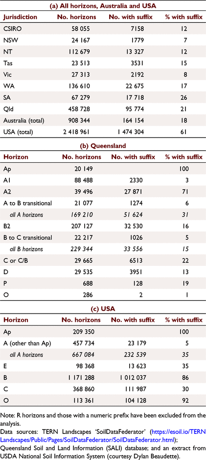
A shortcoming of the Handbook is that there is no introduction to the section on alphabetic horizon suffixes, and hence no guidance on their general purpose or conventions governing their use. In contrast, other horizon systems prescribe the use of alphabetic suffixes and have clear rules governing how specific symbols can be used, and which take precedence over others. Since the use of alphabetic horizon suffixes in Australia is not mandated, it is not surprising that their application is inconsistent. The usage of alphabetic horizon suffixes in soil horizon notation, as recorded in soil databases in both Australia and the USA has been investigated, and the results are summarised in Table 5. The key observations follow:
-
the overall frequency of suffix usage in Australia is much lower than in the USA (18% vs 61%)
-
the rate of suffix usage for A horizons is similar – e.g. 31% in Queensland vs 35% in USA
-
in the USA, suffix usage in B horizons is almost ubiquitous – 86% of B horizons have a suffix, while in Australia the rate is much lower (e.g. 15% in Queensland).
|
As expected, suffix usage for A horizons (A1 horizons in Australia) tends to be low, because there are less suffixes specifically available for them, and the attributes that are signified by suffixes in the B horizon do not often occur in A horizons (e.g. carbonate accumulation). The suffix ‘p’ for cultivation is clearly the dominant suffix used. The high rate of suffix usage for A2 horizons in Australia is notable, at least in Queensland – where 71% have a suffix, of which 97% are for bleaching (‘e’ and ‘j’).
Australia and the USA have a similar set of suffixes that can be used with B horizons, yet their usage in Australia is far lower. Among the Australian states, South Australia is an exception, where 37% of B horizons have a suffix, of which 91% are ‘k’ for the accumulation of carbonate. In the USA, the ‘t’ suffix is allocated in 55% of B horizons, compared to <10% of B2 horizons in Australia (e.g. 7% in Queensland, 1% in South Australia). There is almost certainly a perception in Australia that clay increase has already been captured by the B horizon designation (and also field textures), so that the suffix ‘t’ does not add sufficient extra information to have it recorded.
Another factor could be that the Handbook does not include horizon suffixes specifically relevant to two soil types that are very common in Australia. Australia has a huge area of Vertosols, but there is no horizon suffix to cater for their ‘structural B horizon’ as described in the Handbook. This would not necessarily be equivalent to ‘ss’ in the USDA system or the ‘i’ in the FAO system – both for the presence of slickensides. The existing suffix ‘w’, used internationally for generally weak development of structure and/or colour, is clearly not appropriate for Vertosols. Having a suffix that signifies a ‘clear or abrupt texture-change’ should also be considered, as this is both an important feature for soil profile function and in the classification of Australian soils.
The low usage of soil horizon suffixes in field descriptions in Australia, especially for B horizons, is a concern as noteworthy features of horizons are not being captured in the horizon notation. This diminishes the utility of soil databases, as the interrogation of databases based on horizon notation is less effective. It is suggested that the problem is in part due to the fact that Australia has a system of numeric horizon designations, and alphabetic suffixes automatically take second place. If the alphabetic suffix forms part of the horizon name (e.g. Ap), it assumes a greater significance, and consequently there may be more incentive to have it recorded.
Typical descriptions for soils in the USA can be seen by interrogating the USDA-NRCS website for Soil Series descriptions (Soil Survey Staff, Natural Resources Conservation Service, USDA 2022), or the USDA online portal for soil survey reports (NRCS USDA soil surveys online portal 2022). In the USDA system, all the available suffixes that apply to a particular horizon must be listed, which in some instances can lead to an unwieldly horizon notation that may be an undesirable outcome. The FAO guidelines (FAO 2006) state that more than three suffixes ‘are rarely used’.
The New Zealand soil horizon notation system (Clayden and Hewitt 1994) provides an exceedingly comprehensive system of horizon suffixes. For example, the B horizon has 28 possible iterations indicated by alphabetic suffixes, either alone or in combination, e.g. Bt, Btg and Bw(g). Utilising such a large list of suffixes would therefore require experience and additional time to use effectively. To deal with the limited number of letters in the alphabet, letters may be used twice for different horizons (e.g. in the FAO system ‘i’ is for slight decomposition in O and H horizons, and for slickensides in B horizons), doubled up (e.g. in the USDA system ‘s’ is for illuvial sesquioxides, while ‘ss’ is for slickensides), or other symbols (e.g. ‘@’ for cryoturbation and ‘δ’ for high bulk density in the FAO/WRB system).
In summary, soil horizon notation in Australia is convoluted and unnecessarily complex. A schema that employs both numeric and alphabetic suffixes is less intuitive, and there is a tendency for alphabetic suffixes to be omitted. The rigorous and consistent application of alphabetic suffixes in other soil horizon systems may be an additional burden for the field surveyor, but if applied correctly and judiciously, guarantees a succinct summary of soil horizon attributes, which in turn facilitates the efficient communication of key soil properties.
Transitional (intergrade) horizons
In the Australian soil horizon system, the A3, B1 and B3 transitional horizons have a status equal to ‘main’ horizons such as A1 and B2. These designations can be adapted to all soils that have gradually intergrading horizons, including many Australian soils where horizon differentiation is poor. However, as already pointed out, this naming convention is a relic related to the origins of the scheme in the northern hemisphere, where the subhorizons were numbered according to their genetic positions relative to each other (Kellogg 1937). Furthermore, in the genetic sense, ‘transitional’ implies a process of dynamic change from one horizon to another. The term ‘intergrade’ is therefore preferable as it does not imply that the two horizons share a common origin.
Numerically designated transitional horizons can lead to confusion in the interpretation of soil profile information. For example, the Handbook (McDonald and Isbell 2009, page 157) shows an example soil profile with the following horizon sequence: A1, A3, B2, B3, C1 and C2. An experienced Australian soil surveyor will recognise that the numeric suffixes here are being used for three different purposes – for specifically defined ‘main’ horizons (A1 and B2), transitional horizons (A3 and B3) and horizon subdivisions (C1 and C2). However, such nuances would almost certainly not be appreciated by a layperson trying to interpret the horizon notation.
Since numerically designated horizons are no longer recognised in other soil horizon systems (e.g. FAO from 1974; USDA from 1982), all transitional horizons in the A-E-B-C schema, are signified by two-letter codes (e.g. AB), from which the nature of the horizon can be deduced intuitively. Convention dictates that the first letter indicates the horizon whose properties dominate.8
The Handbook (McDonald and Isbell 2009) states on page 151 that two kinds of transitional horizon are distinguished, but clearly the Handbook specifies three types of transitional (intergrade) horizon:
-
numeric suffixes (as in A3, B1 and B3), where the letter signifies the dominant horizon
-
two-letter codes, e.g. AB which signifies a horizon with properties of both the A and the B, but not dominated by either
-
two-letter codes for combination (or mixed) horizons, e.g. B/C where the first letter indicates the horizon that makes up the greater volume.
This is another example of the Australian soil horizon system having a hybrid structure. The original numerically designated transitional horizons are retained, and a unique interpretation of the two-letter transitional horizons (e.g. AB and BC) is also adopted. According to the Handbook, the two-letter codes can only be used where the subordinate properties of one horizon do not dominate the transitional zone, i.e. each horizon must contribute approximately 50% of the soil properties. Given that attributes in soil profiles generally occur as a continuum and that horizons grade into one another, it could be expected that such transitional horizons would be relatively uncommon, or very thin (as originally specified by Soil Survey Staff 1951).
On the other hand, Isbell (1996) chose to align the ASC with USDA practice (Soil Survey Division Staff 1993) in how transitional horizons are understood. Isbell apparently recognised that for example, there is conceptually no difference between the B3 of the Handbook and the BC of the USDA Soil survey manual – in both, the properties of the B horizon dominate, but there are subordinate properties of the underlying C. Hence, because of the additional interpretation provided in the ASC, there are four types of transitional horizon recognised in Australia.
The various approaches to interpreting transitional horizons are summarised in Table 6. It should be noted that in the Handbook, there is no provision for horizons that intergrade to the C horizon and are dominated by properties characteristic of the C. In other systems, this situation is catered for by CA or CB horizons, but according to the Handbook this notation can only be interpreted as a transitional horizon in which the properties of neither horizon dominate. Technically, a C/B horizon is possible, but this is a mixed (combination) horizon rather than a true intergrade.

|
The Handbook states that the B3 transitional horizon may apply between the B2 and any subsolum material (if not C). The New Zealand guidebook (Clayden and Hewitt 1994) goes further by stating that a transitional horizon can be designated even if the master horizon to which it is apparently transitional is not present. For example, an AB horizon can be recognised where the underlying layer is bedrock (R), and a BC horizon can be recognised even if no underlying C horizon is identified.
The situation regarding the use of transitional (intergrade) horizons in Australia is clearly messy, and supports the contention that the Australian soil horizon system needs substantial revision.
C and D horizons
While the broad concepts underpinning the A and B horizons are relatively settled, the definition and application of C and D horizons are more ambiguous and less consistent – except that they are generally referred to as being ‘below the solum’. The term ‘solum’ is not defined in the Handbook – only referred to as the ‘AB profile’. The third edition of the ASC (Isbell and National Committee on Soil and Terrain 2021) defines the solum as ‘the surface and subsoil layers that have undergone the same soil forming conditions’, and states that it may include P and O2 horizons. The USDA Soil survey manual (Soil Science Division Staff 2017) specifies that the solum ‘includes all horizons now forming’,9 which may include buried layers if they have acquired some of their attributes from currently active soil-forming processes. This manual then states that ‘solum’ and ‘soils’ are not synonymous: ‘Not everyone will agree about the exact extent of the solum in some soils. For example, a certain level of subjectivity is involved in differentiating transitional BC or CB horizons from C horizons or in determining which properties observed are the product of active pedogenic processes’.
Clearly, aspects of the solum are speculative. Soil Science Division Staff (2017) suggest that its use in technical definitions ‘should be avoided’, although they still refer to C horizon materials as being ‘like or unlike the material from which the solum has presumably formed’ – words adopted in the Handbook as well as in FAO (2006). Significantly, however, the WRB (IUSS Working Group WRB 2022) has removed all reference to the solum,10 while referring to the ‘subsolum’ as being any material occurring below the diagnostics of the WRB.
At its inception, in the early Russian schemes and those first codified in the USA, the C horizon signified soil parent material (see Fig. 3), and this notion was retained in Australia by Northcote (1971, 1979). However, the concept of C horizon materials has since broadened to ‘layers little affected by pedologic processes’ – words first coined by Soil Survey Staff (1962) and widely adopted since. However, ambiguity remains. Tandarich et al. (2002) describe the current ‘dogmatic’ C horizon definition as vague, mainly because of the lack of differentiation between the pedologic soil profile and the often much thicker geologic weathering profile below. Birkeland (1984) noted that especially with very thick weathered zones (e.g. as shown in Fig. 5), it is very difficult to separate the products of soil formation from those due to other physical and chemical changes that have acted on parent materials. McDonald and Isbell (2009) seem to concur that C horizons are ambiguous, by stating that they may be described according to either the soil profile or the substrate chapters of the Handbook.
The Handbook makes no mention of accumulations, cementation or gleying as being potentially associated with C horizons. However, from 1937, USDA soil survey guidelines have specified that accumulations of carbonate and gypsum can be designated as distinct layers in the C horizon by using alphabetic suffixes (see Fig. 3). FAO (2006) states that such accumulations, even if indurated, may be included in C horizons, unless the layer is obviously affected by other pedogenetic processes (i.e. those related to overlying horizons) – in which case it would be a B horizon. Soil Science Division Staff (2017) and FAO (2006) also permit strong gleying in C horizons if no other pedogenic changes are present. Hodgson (1974) proposed eight alphabetical suffixes (or suffix combinations) that could be used with C horizons in England and Wales – for the degree of consolidation, for gleying and for secondary accumulations of carbonates and gypsum. Six suffixes (or combinations) have been specified for use with C horizons in New Zealand (Clayden and Hewitt 1994).
In designating and describing C horizons, the critical task is to assess the nature of the alterations and/or the accumulations if present – i.e. whether they are due to currently active processes in the soil above, relict features or only to geologic processes.
In the absence of guidance from the Handbook, Australian pedologists have indeed been allocating alphabetic suffixes to C horizons. In Queensland, 22% of C horizons have been allocated an alphabetic suffix including ‘k’ for carbonate, ‘y’ for gypsum and ‘m’ for strong cementation. However the suffix ‘u’ for reduction associated with acid sulfate soils (a code not in the Handbook) makes up 91% of C horizon suffixes used.
The Handbook has a horizon suffix ‘r’ for ‘consolidated weathered material that can be dug with hand tools’, although the suggestion that it be used specifically with the C horizon as in Cr, was deleted in the second edition. An equivalent Cr is specified in the USDA Soil survey manual for ‘moderately cemented C layers with an excavation difficulty of low to moderate’. Birkeland (1984) uses Cr for the zone of weathered rock between the soil and underlying rock, if it can be shown that this has been formed in place – a concept that extends to saprolite.
The USDA Soil survey manual (Soil Science Division Staff 2017) states that soil material formed in already highly weathered materials should be designated as C if they do not meet the requirements of other horizons. This suggests that the deeper soil layers in landscapes such as that shown in Fig. 5. could be designated as C rather than B horizons.
In early concepts of the soil profile, a D layer was included for material below the C horizon or layer (Darwin 1881; Dokuchaev 1900, as cited in Tandarich et al. 2002). The D horizon was codified in USDA systems (Kellogg 1937; Soil Survey Staff 1951) to recognise contrasting stratigraphic material below the C horizon (see Table 7), including hard rock, which was denoted ‘Dr’. However, there was an important change in the 1962 ‘soil horizon supplement’ to the USDA Soil survey manual (Soil Survey Staff 1962). Previously, two C horizons had been recognised: C1 for slight alteration and C2 for unaltered material. In 1962, this distinction was dropped, being regarded as ‘untenable to apply in the full range of materials recognised as C’. From then on, numbers were used to signify any vertical sequence of contrasting C layers, and therefore the D horizon was rendered obsolete. Materials previously regarded as D were now included with C horizons, except for Dr material, which became the R (rock) layer. Also included with C was the former G (gley) horizon, unless this could be accommodated within B horizons. The evolving concepts and definitions of C, D and R horizons/layers in USA and Australia are summarised in Table 7.

|
Almost all national soil survey organisations have followed the lead of the USDA – a D horizon is no longer recognised, with only two exceptions known. Both Australia and Russia have retained a variation of the original USDA concept. In Russia, D layers are used to signify non-consolidated ‘underlying rock’, in contrast to C layers, which are also unconsolidated but ‘soil-forming’, and R which is ‘hard rock’ (Khitrov and Gerasimova 2022). An example is the mineral substrate underlying dry peats (Gerasimova 2001). The D is also used informally in Russia for unconsolidated material below a lithologic discontinuity that is significantly contrasting in terms of mineralogy and particle size distribution (Goryachkin et al. 2013). In the latter case, the same horizons would be recognised as 2C, 3C etc. according to FAO (2006).
The retention of the D horizon in Australia is in part due to its inclusion in Northcote’s Factual key (various editions from 1960 to 1979). As already mentioned, Northcote’s C horizon retained the parent material concept; his D horizon was for (other) soil material ‘below the solum (AB profile) that is unlike the solum in general character and not C horizon’. However, Northcote also stated that a D horizon could be recognised by ‘the contrast in pedologic organisation between it and the solum’, and that ‘the form of fabric of D horizons has resulted from some earlier cycle of soil-forming processes’.
McDonald (1977) adopted the horizon definitions of Northcote closely (including C horizons as being parent material), but regarding the D horizon stated that it ‘has been modified to allow for naming horizons of buried soils where these cannot be reliably designated’. This definition was repeated verbatim in the first edition of the Handbook (McDonald and Isbell 1984) but with the addition of ‘lithologic discontinuities’.
Meanwhile, the Handbook adopted the broader concept of C horizons used internationally, as being either like or unlike the material from which the soil presumably formed. But the Handbook failed to highlight the fact that its C and D horizon concepts had changed subtly from those of Northcote. Application of the D horizon was now restricted to lithologic discontinuities and buried soils only, and where reliable A-B horizon nomenclature cannot be designated. As per Northcote, the Handbook states that the D horizon can be recognised by its ‘contrast’ in pedological organisation. The assumption is therefore made that the D horizon must display pedologic organisation, usually assumed to be structure, although this is not stated as a requirement. In fact, the D horizon is defined by what it is not, rather than by what it is.
If D horizons can be designated only in the context of discontinuities, then all instances of D must have a numeric prefix (for the discontinuity) and/or be followed by the suffix ‘b’ (for buried). For example, if a horizon as part of a buried soil cannot be reliably named 2B2b, then it could be designated 2Db. The Handbook (McDonald and Isbell 2009, page 157) provides illustrated examples of soil horizon nomenclature in the context of lithologic discontinuities, but these do little to clarify the D horizon concept, as the reasons for designating horizons as D (in preference to other horizons) are not provided.
What is clear, however, is that designating horizons below lithologic discontinuities using Australian soil horizon nomenclature is more difficult, due to the fact that the numeric suffixes used with A and B horizons convey a particular taxonomic meaning. Convention dictates that the sequence of horizon names is to be maintained, regardless of the discontinuity. For example, in the sequence A1-A2-B21-2B22-2B3-2C1-3C2, there is a discontinuity below the first B horizon, signified by the prefix ‘2’. But if two B horizon sequences are separated by C horizon material, how should the lower B horizons be named? Designating them as B2 is problematic, as the Australian B2 horizon is generally expected to exhibit the ‘maximum development’ of pedologic organisation with reference to horizons immediately above or below. However, soil surveyors in the rest of the world can more freely designate horizons below discontinuities. For example, in the sequence A-Bt1-Bt2-C1-C2-2B1-2B2-3Bw-3C1-3C2, the B horizons below the discontinuity can be designated as 2B1 and 2B2, as the numeric suffixes simply indicate horizon subdivisions and are devoid of taxonomic implications. In Australia, the convenient solution in this case would be to allocate the lower B horizons as D horizons, but this is less effective for communication as the properties pertaining to D horizons are not readily conveyed by the D horizon notation.
Clearly, the Australian D horizon will often not be part of an A-B-C-D horizon sequence and may in fact be located quite close to the soil surface. In Queensland, 45% of all D horizons described have an upper depth of <1.0 m, therefore almost certainly having acquired at least some of their attributes from current soil forming processes. Therefore, to claim that these horizons lie ‘below the solum’ (i.e. the portion of the profile affected by climate and organisms), as required by the D horizon definition, is doubtful. If a D horizon is now a ‘miscellaneous’ horizon, why call it a ‘D’ at all, rather than a less ambiguous ‘X’ or ‘Y’?
A true test of how both C and D horizon concepts are being interpreted is to explore how they are being applied in practice. Examples of their usage in the Compendium of Australian soils (McKenzie et al. 2004) and more extensively in databases, demonstrate uncertainty and inconsistency in how both C and D horizons are being allocated in soil profile descriptions. For example:
-
D horizons are mostly being designated without signifying either a lithologic discontinuity or a buried soil
of approximately 30 000 D horizons described in Queensland, 76% do not have a numeric prefix, and of those, 75% were described after the Handbook was first published in 1984.
-
The allocation of ‘D’ sometimes appears to be based on the presence of soil structure or some other pedologic feature, but in other cases no evidence of pedologic organisation is described. Furthermore –
26% of D horizons in Queensland are described as having a massive or single-grain grade of pedality and a further 8% have only a weak structure
20% of D horizons in Queensland are described as having a ‘coarse’ field texture that is neither clayey, clay-loamy or silty.
-
Calcrete and ferricrete pans are variously described as C or D horizons (if not B).
In the soils of coastal environments, estuarine muds and sands below the current soil are allocated as C horizons, while deeper sediments (usually clays) belonging to a pre-Holocene (Pleistocene) surface, at depths usually >5 m, are designated as D horizons, despite the fact that pedological organisation is generally absent (e.g. Malcolm et al. 2007).
An interpretation of the original D horizon concept as being any stratum below the C horizon that is not rock is evidently still being applied in Australia, rather than the now restricted definition of the Handbook. In the description of deep regolith profiles, in hard rock geology in Queensland, D horizons have been designated at great depths (often >8 m from the soil surface). At such depth, attributes that resemble pedogenic features (e.g. gleying and mottling, and stress fractures that mimic pedogenic structure) are most likely geogenic rather than pedogenic. However, Schaetzl and Anderson (2005) noted that in some soils, illuvial clay can penetrate ‘well below the solum’ and into the substrate.
The D horizons designated at such depths (in either consolidated or consolidated sediments) are clearly substrate rather than soil, and this creates another conflict with Handbook definitions. The D horizons as currently circumscribed are specifically excluded from substrate, which is defined by Speight and Isbell (2009) as ‘materials and masses of earth or rock that do not show pedological development’, including the ‘the R horizon and that part of the C horizon that shows no pedological development’, but excluding ‘the solum, buried soil horizons (including D horizons), and pans’.
An interpretation of the original D horizon concept has been retained in Australian regolith science, as defined in the CRC–LEME regolith glossary (Eggleton 2001), see Table 7. To foster the integration of the pedologic and geologic aspects of regolith, Tandarich et al. (1994) proposed a common horizon nomenclature from the surface to unaltered rock – in what they called a ‘unified’ pedoweathering profile (PWP). The PWP includes a C horizon that is limited to the modified component of the traditional C, i.e. the part that shows some ‘pedologic connection’ to the overlying solum. A revised D horizon concept is introduced for zones that are unaltered by pedogenic processes and do not have the hardness of bedrock (R). The revised master horizon concepts are D – unaltered; C – chemically altered (e.g. oxidised, gleyed, with geologic ‘ghost’ structure); and B and A – biologically, chemically and physically altered. No national soils agency has validated this revised D horizon concept, but it has a level of acceptance in geomorphology. Schaetzl and Anderson (2005) recommend its adoption as a logical extension of horizon nomenclature and point out that a similar ‘D’ concept was used by Ruhe (1975) for an ‘unoxidised and unleached zone’. They also suggest that such a D horizon could include fresh sediments such as volcanic ash and beach sand, as well as sediments buried beneath water.
To help rectify the historical bias in soil description and classification toward the upper part of the soil profile, Juilleret et al. (2016) proposed a comprehensive classification system of subsolum materials for use in soil survey. Juilleret et al. (2018) summarised progress made in ‘whole regolith pedology’, arguing there would be benefits for a wide range of users (including water quality and geohydrological applications) if subsolum features were incorporated into soil information systems. In a neat way, this idea links back to the early iteration of the D horizon as proposed by Kellogg (1937), i.e. ‘any stratum underneath the soil that is not parent material but may have significance to the overlying soil’.
In summary, the definition of C and D horizons (as well as substrate material) in the Handbook is somewhat ambiguous and incomplete. As a result, current usage is uncertain, revealing a variety of subjective interpretations and applications that are inconsistent with Handbook definitions. The value of retaining a subjective pedological term such as ‘solum’ is questioned, and to be useful, additional clarity is required. The use of a D horizon that has application only to lithologic discontinuities and buried soils is unique to Australia, and seems to be required only to cater for the explicitly defined A1, A2, B1, B2 and B3 horizons that make it more difficult to allocate reliable horizon designations below discontinuities. Meanwhile, a refinement of the original D horizon concept has been given renewed recognition in regolith science. This should be considered for adoption in Australia, but its application would first need to be tested, especially to establish the criteria for recognising different types of substrate alteration.
Organic (O and P) soil horizons
The contrasting definitions and schemas relating to organic soil horizons are summarised in Table 8. The USDA system is the simplest, with only O horizons. The FAO system has O for surface organic materials in various states of decomposition and H horizons for wet peaty material (i.e. those that are saturated for prolonged periods, or were once saturated but are now drained artificially). The United Kingdom, Canada and New Zealand have all adopted the older European system (after Kubiëna 1953) where ‘O’ is for wet peaty materials, ‘H’ is for well decomposed (humified) surface deposits, and ‘F’ and ‘L’ are for less decomposed surface litter. Both USDA and FAO use ‘i’, ‘e’ and ‘a’ horizon suffixes to indicate the degree of decomposition, but those using the older European system have a different set of suffixes. Australia is the only country to use the symbol ‘P’ for organic horizons.

|
Although the symbols are different, the Australian schema for organic soil horizons appears to be based on Hodgson (1974), which was later expounded in the Canadian system (Soil Classification Working Group Canada 1998) and New Zealand (Clayden and Hewitt 1994). The O and P horizons are differentiated by how the organic materials have accumulated – O from decomposed litter on the mineral soil surface and P from the residue of materials accumulated under conditions of excessive wetness. In the Canadian system, materials equivalent to P horizons are specified as being ‘mainly mosses, rushes and woody materials’. A key issue with the Handbook definition is that the O1 horizon includes only organic debris that has accumulated on the mineral soil surface; litter that has accumulated on the surface of a peat or other organic layer is therefore excluded. FAO (2006) specifies that Oi horizons can be on top of either mineral or organic soils.
Again, the Australian soil horizon system is constrained by its use of numeric horizon suffixes (e.g. P1 and P2), instead of the widely understood alphabetic suffixes. In describing Organosols, soil surveyors often see the need to clarify the type of material (e.g. sapric peat) as a note in addition to the horizon designation. The Australian P1 horizon (fibric peat) correlates with the FAO ‘Hi’ horizon, but since P2 includes both hemic and sapric peat, there is no direct correlation with the FAO ‘He’ and ‘Ha’ horizons. The Handbook practice of dual horizon definitions is repeated, i.e. an introductory statement followed by secondary definitions. Again this can lead to confusion. For example O horizons are defined as being ‘in varying stages of decomposition’, but it is later stated that the O1 horizon consists of ‘undecomposed’ organic debris. Again it is not clear if a singular O horizon can be designated or whether it must be an O1 or O2 horizon.
A key point of conjecture, with regard to organic horizons generally, has been the treatment of undecomposed plant litter. The Australian system (which does not use the term ‘litter’) is ambiguous. The O1 horizon materials are defined as ‘undecomposed’, but with a qualifying statement (‘the original form of the debris can be recognised with the naked eye’) that would be redundant if the material was not at least partially decomposed. FAO (2006) is also ambiguous. In seeking clarification, the WRB fourth edition (IUSS Working Group WRB 2022) defines a litter layer as ‘containing >90% (by volume) recognisable dead plant tissues that are not, or only slightly decomposed’, and this material is specifically excluded from O horizons. Where applied (e.g. in Canada and New Zealand), the L layer is for ‘fresh’ litter, but it is assumed there is partial decomposition (e.g. ‘deposited in the previous season’). The USDA system is explicit – undecomposed plant litter is excluded from O horizons.
There is a lack of clarity in the Handbook regarding the quantitative diagnostics for the field identification of both O and P horizons. However, some useful diagnostic information is included in the sapric and fibric field texture qualifiers (which may be applied to any mineral soil horizon). Peaty materials are more thoroughly defined in the ASC (Isbell and National Committee on Soil and Terrain 2021), although the proportion of visible plant remains in each type of peat is not specified. Both the FAO and USDA systems specify a percentage of visible plant remains for each of the ‘i’, ‘e’ and ‘a’ horizon suffixes (see Table 8). FAO (2006) has a useful table that summarises the field diagnostics and coding for the degree of decomposition and humification of peats (both wet and dry peat).
Since P horizons have formed under water or in conditions of excessive wetness, they are by definition hydromorphic. However, the range of hydrologic conditions experienced by P (or O) horizons is not stated in the Handbook. The New Zealand system (Clayden and Hewitt 1994) specifies that the equivalent materials (O horizons in New Zealand) are saturated with water for ‘at least 30 consecutive days in most years, or have been artificially drained’. A similar criterion has been adopted for H horizons in the WRB (IUSS Working Group WRB 2022).
How ‘peaty’ can O2 horizons be? In the ASC, they are included amongst ‘peaty’ horizons. However, the WRB (IUSS Working Group WRB 2022) specifies that terrestrial O horizons in the WRB are generally not regarded as peats. How appropriate is the term ‘peat’? Neither of the two international systems (USDA or FAO) use the word ‘peat’ in their definitions of organic soil horizons. The USDA Soil survey manual has ‘peat’ as a category of saturated organic soil material, along with ‘muck’ and ‘mucky peat’ but the term is not used for non-saturated organic soil materials.
There is now more information on the range and distribution of organic soils in Australia compared to when the Handbook was compiled. Isbell and National Committee on Soil and Terrain (2021) point out that the number of soil profiles described in Tasmania and included in national databases has grown 10-fold since 1996. Folic Organosols are a case in point – they are relatively thin and by definition (Isbell and National Committee on Soil and Terrain 2021) have formed directly over a rocky or mineral soil surface and are never saturated for more than several days at a time. Large areas of south-west Tasmania are dominated by Organosols of this type – i.e. shallow ‘well-drained peats’, often known as blanket bogs (Isbell et al. 1997). While recognised as peats, they do not appear to meet either the ‘accumulation’ or ‘excessive wetness’ criteria specified for P horizons in the Handbook. Hence, it is uncertain whether these materials should be designated as O or P horizons. The WRB (IUSS Working Group WRB 2022) has an equivalent folic diagnostic horizon for well-aerated organic materials that occur at a shallow depth and are saturated for less than 30 consecutive days in most years. Dry peaty soils are also recognised in the Russian soil classification, where peat has accumulated directly on the mineral substrate but is not related to water saturation (Gerasimova 2001). Cool temperatures therefore seem to be vital for the accumulation and maintenance of these organic materials.
There would be less ambiguity in the definition of organic soils in the Australian system if it adopted a schema similar to the one used in Canada and New Zealand. This could be simplified by amalgamating the ‘F’ and ‘L’ layers, which would replace the current Australian O1 horizon, and exclude undecomposed litter. The ‘H’ would replace the current O2 and clearly be a ‘peaty’ horizon in terms of the ASC (as well as accommodating folic organic horizons) and ‘O’ would replace the current P horizons and have three subhorizons, signified by alphabetic suffixes for fibric, hemic and sapric organic materials (or their equivalent).
Surface soil (A1) horizons
Internationally, there is considerable conceptual agreement regarding the A horizon, i.e. those correlating with the Australian A1 horizon (see Table 3). However, there are several issues that warrant discussion in this review.
The notion of a darker and/or humic horizon obviously holds true for temperate and moist climates, such as where the A horizon concept originated (see Fig. 1). However, in environments that are warm and arid, it is not uncommon for the surface horizon to be paler in colour than the underlying subsurface horizons, and without an obvious accumulation of organic matter. Some examples are illustrated in the Compendium of Australian soils (McKenzie et al. 2004).11 Because pedological development is clearly not evident in many Arenosols, subtle edits were made in the ASC third edition to account for this, i.e. ‘in some soils there may be negligible, if any, horizon development’. Other examples of surface horizons that do not fit the traditional concept of A horizons are in the Desert Loams, illustrated in Stace et al. (1968), which now generally classify as Sodosols or Sodic Chromosols (Isbell and National Committee on Soil and Terrain 2021). Salt-affected Rudosols/Hydrosols (formerly Solonchaks) may also have paler coloured surface horizons, often with lower organic carbon contents. FAO (2006) mentions the existence of such exceptions in their definition of A horizons.
In some soils of arid climates, including the examples mentioned above, it may also be difficult to find evidence that the surface (A1) horizon is the zone of ‘maximum biologic activity’, as prescribed in the Handbook. As a criterion for the A horizon, this is another unique feature of the Australian soil horizon system and another legacy from the USDA Soil survey manual of 1951.
Expanding the options available for categorising surface soil horizons would also be a useful endeavour. Currently there is specific provision only for the following: soils that are ploughed (Ap), soils with significant faunal activity [e.g. worm casts (A1f)] and gleying or oxidised root channels (A1g). The suffixes ‘j’ and ‘e’ for bleaching may also be used, although these generally apply only to subsurface A2 horizons. In the German soil mapping guide (Ad-hoc-AG Boden 2005, cited in Fox et al. 2014), designation of the A horizon can be supplemented by 13 lower case prefixes for geogenic or anthropogenic features and 10 lowercase suffixes for pedogenic features. Common pedogenic suffixes (apart from the ubiquitous ‘p’) used in Germany are ‘h’ for organic matter enrichment, ‘k’ for enriched by bases or nutrients by fertilising, ‘x’ for mixed by bioturbation and ‘c’ for secondary carbonate.
An obvious additional category worthy of consideration for Australia would be an Av horizon for soils in arid conditions with vesicular pores, as in the USDA Vesicular (V) horizon (Soil Science Division Staff 2017). Desert pavement properties (and vesicular pores) are captured in the ASC by the Pedaric property, but are not currently recognised in the Handbook in terms of a surface condition type or as an alphabetic horizon suffix.
Another issue is how to designate recent surficial (e.g. alluvial, aeolian or anthropogenic) deposits that do not meet the A horizon criteria. These layers have not been present for a sufficient length of time to influence the properties of the underlying soil materials and/or they may retain fine stratification. Both FAO (2006) and Soil Science Division Staff (2017) state that if such deposits retain fine stratification, they are not considered to be A horizons, unless cultivated. In USDA Soil Taxonomy (Soil Survey Staff 2014), a caret symbol is used as a prefix to identify human-transported deposits, i.e. ^A. For the purposes of soil classification in the ASC (Isbell and National Committee on Soil and Terrain 2021), surficial deposits less than 0.30 m thick that show only minimal pedological development are regarded as a depositional phase of the soil below, but the horizon nomenclature is not specified.
Summary
The history of pedology and soil survey in Australia is closely linked to its development in the USA, where early European soil profile concepts with a strong emphasis on genetic soil classification and zonal soils became entrenched in soil survey guidelines during the first half of the 20th century. Over time, Australian soil scientists recognised that these concepts had to be broadened and modified to suit a continent with a high proportion of older, deeply-weathered landscapes. However, the USDA Soil survey manual of 1951 (Soil Survey Staff 1951) was widely embraced in Australia, as it was in other parts of the world. The USDA 1951 soil horizon schema became a de facto international standard that was widely adopted by many jurisdictions (including the FAO in 1968), and it provided the basis for the soil horizon scheme adopted in the first edition of the Handbook in 1984.
However, just as the Handbook was being conceived, changes were underway elsewhere. An international working group proposed a new system with a simplified set of master horizons, supplemented by the prescriptive use of alphabetic suffixes. A soil horizon schema based on the new structure was adopted in England and Wales in 1974, and then by the FAO in 1977. In turn, significant elements of the new system were adopted by the USDA in 1982, and eventually by almost all soil survey organisations around the world. Australia alone has retained the relict A1-A2-A3-B1-B2-B3-C-D-R schema for mineral soil horizons, which consequently is now a uniquely Australian system. The O1-O2-P1-P2 schema for organic horizons is also unique, and similarly poses issues in correlating with other systems.
No singular soil horizon system could adequately deal with the incredible diversity in soil landscapes and soil profiles found in Australia. However, the international A-E-B-C schema, together with standard intergrade horizons, is a simpler, more flexible system that has been successfully applied around the world to suit a wide range of soil-forming environments.
Employing two sets of horizon suffixes (both numeric and alphabetic) in the hybrid Australian schema results in a convoluted final notation. With a larger number of defined horizon entities (for mineral soils) and with numeric suffixes being used for three different purposes, the Australian system is more complex than schemas used internationally. Having four different types of transitional (intergrade) horizon recognised in Australia is an additional conundrum.
The use of alphabetic horizon suffixes is not mandated in Australia, and there are uncertainties in how they should be applied. Hence their application is somewhat ad hoc, as evidenced by comparing the soil horizon databases of both Australia and USA. The rigorous application of alphabetic suffixes in other soil horizon systems guarantees a succinct summary of soil horizon attributes, which in turn facilitates the efficient communication of key soil properties.
Rejection of the E horizon in Australia primarily because of the assumed genetic implications of eluviation is inconsistent and no longer relevant. Ironically, it can be argued that genetic implications are less pervasive in the international A-E-B-C schema, as horizons are not numerically designated, transitional horizons are de-emphasised and the focus is on objective, morphologically-based horizon suffixes. The earlier Australian soil horizon scheme used in Northcote’s Factual key was also a simpler system, based on objective, morphological criteria.
The B horizon is in a sense the most important soil horizon, as its properties tend to dominate overall soil functionality. Yet duplication in the definitions, plus its existence in three distinct entities (B1, B2 and B3), elicits uncertainty about the precise nature of the B horizon in the Australian system.
Improving clarity in the definitions of all horizons in the Australian system, and providing additional guidance regarding appropriate usage, would greatly benefit soil data collection and the communication of soil information. In particular, there are ambiguities around the C, D and O horizons and as a consequence, current usage reveals a variety of subjective interpretations and applications that are sometimes inconsistent with Handbook definitions. Including a D horizon that has application only to lithologic discontinuities and buried soils is unique to Australia – its existence seems to be required largely to cater for the fact that the numeric suffixes used with A and B horizons convey a particular taxonomic meaning.
Recommendations and discussion
Despite two revisions of the Handbook since its first edition in 1984, there has been no committee-led review of the soil horizon system. A comprehensive re-evaluation is therefore a high priority, and should initially include the following key steps:
-
Summarising the advantages and disadvantages of retaining the current soil horizon system
-
Determining the soil horizon system that has maximum clarity and utility, and would best suit Australian conditions. This should be assessed from an impartial, objective viewpoint
-
Database analysis and field testing by current soil survey practitioners
-
Determine the degree of structural change that is possible or acceptable, given the constraints and costs associated with updating soil databases and soil information systems.
Is the current Australian soil horizon system fit for purpose? It could be argued that it is, as there is a perception that user needs are being met and soil surveys in Australia have been conducted with relative efficiency. If the system is working, why the need for change? However, this review has identified deficiencies in the current system and makes numerous suggestions for improvement.
Chiefly, this review advocates that pedology in Australia would benefit by dispensing with numeric horizon designations and aligning with international approaches including a simpler set of objectively defined master horizons, rationalised intergrade horizons and the more rigorous application of alphabetic suffixes. Changing to a new system could be achieved in stages. The first step could be to remove the problematic transitional horizons (A3, B1 and B3) and replace them with the international interpretation of the AB, BA and BC horizons – which could be done with minimal disruption to databases. By implementing this, the B2 subhorizon (and the D horizon as currently prescribed) would effectively become redundant. No more B2, just B.
Other key recommendations follow:
-
Introduce an E horizon with a carefully designed set of subhorizons, signified by alphabetic suffixes. These would correlate with the current range of A2 subsurface horizons (e.g. A2j and A2e) and provide additional options.
-
All horizons and layers to be defined using clear objective criteria, removing ambiguity and unnecessary duplication, and in doing so:
remove the vestiges of soil genetic inferences that require subjective assessment (e.g. ‘maximum development’)
evaluate whether the term ‘solum’ should remain a component of soil horizon concepts
use definitions and designations that are more applicable to the full range of Australian soils, including those with minimal horizon development.
-
Transitional horizons to be referred to as ‘intergrade’ horizons.
-
Expound the C horizon definition and clarify the full range of materials/attributes that may be included.
-
Clarify the definition and intent of the D horizon, and review its usage – including with regard to ‘substrate’:
then resolve whether it warrants retention in its current form, or whether it should revert to something like its original incarnation, taking into account recent developments in regolith science.
-
Clarify the definitions of the organic horizons, especially with regard to fresh litter and ‘dry peats’, and seriously consider an L-H-O schema for organic soil horizons.
-
Expand the options for categorising the surface soil (currently A1 horizons), especially for vesicular horizons.
-
Review and revise the set of alphabetic horizon suffixes, and provide clear guidelines for their usage.
Updating long-established protocols relating to soil profile description would be no simple task. Major revisions would require sufficient time to be communicated and their adoption planned for. Structural change to the system of soil horizon nomenclature will force overhauls of existing databases, with consequences that could be far-reaching. Harmonising legacy data with an updated system would be another consideration, although advanced digital analytics (including machine learning tools) could be harnessed to assist with this. Each state/territory jurisdiction would need to conduct their own evaluation. Another significant constraint to both reviewing and updating the soil horizon system is the declining institutional support for pedology in Australia, coinciding with a reduction in the number of active practitioners. Regardless of the system being used, adequate training in soil profile description will be an ongoing requirement, along with maintaining standards around data collection and a minimum set of attributes to be recorded.
Alterations to the soil horizon schema in the Handbook would have minimal impact on the ASC. If an update to the Handbook did not coincide with a new edition of the ASC, the minor discrepancies with the ASC could be easily addressed in the short-term with the issue of an addendum sheet, while the online edition could be updated seamlessly.
Conclusion
While ‘long-established’, the soil horizon system prescribed in the Handbook is now unique, and therefore lacks correlation with the revised systems used elsewhere. There is ambiguity and inconsistency in the definition and application of soil horizons in Australia, and the horizon notation is convoluted and complex. A simplified horizon schema based on the systems used internationally, applied with objectivity and focusing on morphological attributes would improve the quality of soil descriptions and hence benefit scientific communication. However, the resources required to scope, plan and implement the required changes would be significant and potentially prohibitive.
Data availability
No new data were generated during the research reported in this article.
Conflicts of interest
The author declares they have no conflicts of interest concerning this research.
Declaration of funding
The research in this article did not receive any funding.
Acknowledgements
The author thanks Lauren Eyre and Mark Silburn for reviewing the original manuscript. Lauren Eyre provided additional helpful comments and edits on a later version of the paper, as did Angus McElnea. Bernie Powell was a useful sounding board for both early and later versions of the paper, and provided many helpful comments. Curtis Monger and Dylan Beaudette assisted with the provision of soil horizon data from the USA, and Stephen Leo helped with the statistics. Ross Searle provided the initial data extract from the SoilDataFederator, and Tim Herrmann assisted with the South Australian data. I also thank two anonymous reviewers for their critique of the paper and their constructive comments and suggestions.
References
Ad-hoc-AG Boden (2005) ‘Bodenkundliche Kartieranleitung.’ 5th edn. (E. Schweizerbart: Hannover, Germany) [quoted in Fox et al. 2014]Beckmann GG, Thompson CH (1960) ‘Soils and land use in the Kurrawa area, Darling Downs, Queensland.’ Soils and Land Use Series No. 37. (Division of Soils, CSIRO: Melbourne)
Birkeland PW (1984) ‘Soils and geomorphology.’ (Oxford University Press: New York)
Brewer R (1968) Clay illuviation as a factor in particle-size differentiation in soil profiles. In ‘Transactions of the 9th International congress of soil science, Adelaide. Vol. 4’. pp. 489–500. (The International Society of Soil Science and Angus and Robertson Ltd)
Bridges EM (1997) Origins, adoption and development of soil horizon designation. In ‘History of soil science: international perspectives’. Advances in GeoEcology 29. (Eds DH Yaalon, S Berkowicz) pp. 47–65. (Catena Verlag GMBH: Reiskirchen, Germany)
Butler BE (1967) Soil periodicity in relation to landform development in southeastern Australia. In ‘Landform studies from Australia and New Guinea’. (Eds. JN Jennings, JA Mabbutt) pp. 231–255. (Cambridge University Press: London)
Canada Soil Survey Committee (1978) ‘The Canada Soil Information System (Can SIS): manual for describing soils in the field.’ (Land Resource Research Institute: Ottawa, Ontario, Canada)
Clayden B, Hewitt AE (1988) A proposal for horizon notation of New Zealand soil profiles. NZ Soil Resources Report SR10 3rd Draft. Department of Scientific and Industrial Research, New Zealand.
Clayden B, Hewitt AE (1994) ‘Horizon notation for New Zealand soils.’ (Manaaki Whenua Press: Lincoln, New Zealand)
Coventry RJ, Holt JA, Sinclair DF (1988) Nutrient cycling by mound building termites in low fertility soils of semi-arid tropical Australia. Australian Journal of Soil Research 26, 375–390.
| Nutrient cycling by mound building termites in low fertility soils of semi-arid tropical Australia.Crossref | GoogleScholarGoogle Scholar |
Crenweige GW, Crout JD, Griffin EL, Golden ML, Baker JK (1981) ‘Soil survey of Brazonia County, Texas.’ (United States Department of Agriculture, Soil Conservation Service in cooperation with the Brazonia County Commissioners Court and Texas Agricultural Experiment Station)
Darwin CR (1881) ‘Vegetable mould and earthworms.’ (John Murray: London). http://darwin-online.org.uk/converted/pdf/1881_Worms_F1357.pdf [Accessed 20 June 2022]
Duchaufour P (1998) ‘Handbook of pedology – soils, vegetation, environment.’ (Balkema: Rotterdam)
Eggleton RA (Ed.) (2001) ‘The regolith glossary – surficial geology, soils and landscapes.’ (Cooperative Research Centre for Landscape Evolution and Mineral Exploration)
FAO-Unesco (1974) ‘Soil map of the world. Vol. 1 Legend.’ (Unesco: Paris) Available at https://www.fao.org/3/as360e/as360e.pdf
FAO (1968) ‘Guidelines for soil description.’ (Soil survey and fertility branch, Land and water development division, Food and Agriculture Organization of the United Nations: Rome, Italy)
FAO (1977) ‘Guidelines for soil profile description.’ 2nd edn. (Soil resources development and conservation service, Land and water development division, Food and Agriculture Organization of the United Nations: Rome, Italy)
FAO (2006) ‘Guidelines for soil description.’ 4th edn. (Food and Agriculture Organization of the United Nations: Rome, Italy)
Fey MV (2010) ‘Soils of South Africa.’ (Cambridge University Press: Cape Town, South Africa)
Fitzpatrick EA (1967) Soil nomenclature and classification. Geoderma 1, 91–105.
| Soil nomenclature and classification.Crossref | GoogleScholarGoogle Scholar |
Fox CA, Tarnocai C, Broll G, Joschko M, Kroetsch D, Kenney E (2014) Enhanced A horizon framework and field form for detailed field scale monitoring of dynamic soil properties. Canadian Journal of Soil Science 94, 189–208.
| Enhanced A horizon framework and field form for detailed field scale monitoring of dynamic soil properties.Crossref | GoogleScholarGoogle Scholar |
Gerasimova MI (2001) ‘Russian soil classification system’. (English translation, Ed. RW Arnold). (VV Dokuchaev Soil Science Institute, Russian Academy of Agricultural Sciences: Moscow)
Glinka KD (1914) Die Typen der Bodenbildung, ihre Klassification und geographische Verbreitung (in German). (Gebrueder Borntraeger: Berlin)
Glinka KD (1927) ‘The great soil groups of the world and their development.’ (English translation by CF Marbut) (Edwards Brothers: Ann Arbor, MI, USA)
Goryachkin SV, Konyushkov DE, Krasilnikov PV (Eds) (2013) Diversity of soils of cold ultra-continental climate. In ‘Guidebook for the ‘Mammoth’ ultra-continental WRB field workshop, 17–23 August 2013. Yakutsk, Sakha, Russia’. (Institute of Geography, Russian Academy of Sciences: Moscow-Yakutsk). Available at https://www3.ls.tum.de/fileadmin/w00bds/boku/downloads/wrb/Guide_Sakha_final.pdf
Guthrie RL, Witty JE (1982) New designations for soil horizons and layers and the new soil survey manual. Soil Science Society of America Journal 46, 443–444.
| New designations for soil horizons and layers and the new soil survey manual.Crossref | GoogleScholarGoogle Scholar |
Hartemink AE, Zhang Y, Bockheim JG, Curi N, Silva SHG, Grauer-Gray J, Lowe DJ, Krasilnikov P (2019) Soil horizon variation: a review. Advances in Agronomy 160, 125–185.
| Soil horizon variation: a review.Crossref | GoogleScholarGoogle Scholar |
Hodgson JM (Ed.) (1974) ‘Soil survey field handbook: describing and sampling soil profiles.’ Technical Monograph No. 5. (Soil Survey of England and Wales, Rothamsted Experimental Station: Harpenden, Herts, UK)
Holt JA, Coventry RJ, Sinclair DF (1980) Some aspects of the biology and pedological significance of mound-building termites in a red and yellow earth landscape near charters towers, north Queensland. Australian Journal of Soil Research 18, 97–109.
| Some aspects of the biology and pedological significance of mound-building termites in a red and yellow earth landscape near charters towers, north Queensland.Crossref | GoogleScholarGoogle Scholar |
International Society of Soil Science (1967) Proposal for a uniform system of soil horizon designations. Bulletin of the International Society of Soil Science 31, 4–7.
Isbell RF (1957) ‘The soils of the Inglewood-Talwood-Tara-Glenmorgan region, Queensland.’ Bureau of Investigation Technical Bulletin No. 5. (Department of Public Lands: Brisbane, Queensland)
Isbell RF (1996) ‘The Australian soil classification.’ (CSIRO Publishing: Melbourne)
Isbell RF, National Committee on Soil and Terrain (2021) ‘The Australian soil classification.’ 3rd edn. (CSIRO Publishing: Melbourne). Available at https://www.publish.csiro.au/book/8016 [Accessed 08 November 2022]
Isbell RF, Smith GM (1976) ‘Some properties of red, yellow and grey massive earths in north Queensland.’ Division of Soils, Technical Paper No. 30. (CSIRO: Melbourne)
Isbell RF, McDonald WS, Ashton LJ (1997) ‘Concepts and rationale of the Australian soil classification.’ Australian Collaborative Land Evaluation Program. (CSIRO Land and Water: Canberra)
IUSS Working Group WRB (2022) ‘World reference base for soil resources. International soil classification system for naming soils and creating legends for soil maps.’ 4th edn. (International Union of Soil Sciences: Vienna, Austria)
Johnson DL (2002) Darwin would be proud: bioturbation, dynamic denudation, and the power of theory in science. Geoarchaeology 17, 7–40.
| Darwin would be proud: bioturbation, dynamic denudation, and the power of theory in science.Crossref | GoogleScholarGoogle Scholar |
Johnson DL, Watson-Stegner D (1987) Evolution model of pedogenesis. Soil Science 143, 349–366.
Johnson DL, Domier JEJ, Johnson DN (2005) Animating the biodynamics of soil thickness using process vector analysis: a dynamic denudation approach to soil formation. Geomorphology 67, 23–46.
| Animating the biodynamics of soil thickness using process vector analysis: a dynamic denudation approach to soil formation.Crossref | GoogleScholarGoogle Scholar |
Juilleret J, Dondeyne S, Vancampenhout K, Deckers J, Hissler C (2016) Mind the gap: a classification system for integrating the subsolum into soil surveys. Geoderma 264, 332–339.
| Mind the gap: a classification system for integrating the subsolum into soil surveys.Crossref | GoogleScholarGoogle Scholar |
Juilleret J, de Azevedo AC, Santos RA, dos Santos JCB, Pedron FdA, Dondeyne S (2018) Where are we with whole regolith pedology? A comparative study from Brazil. South African Journal of Plant and Soil 35, 251–261.
| Where are we with whole regolith pedology? A comparative study from Brazil.Crossref | GoogleScholarGoogle Scholar |
Kellogg CE (1937) ‘Soil survey manual.’ (United States Department of Agriculture, Miscellaneous publication 274: Washington DC)
Khitrov NB, Gerasimova MI (2022) Diagnostic properties and soil forming materials in the classification system of Russian soils: version of 2021. Eurasian Soil Science 55, 1–10.
| Diagnostic properties and soil forming materials in the classification system of Russian soils: version of 2021.Crossref | GoogleScholarGoogle Scholar |
Kubiëna WL (1953) ‘The soils of Europe – illustrated diagnosis and systematics.’ (Thomas Murby and Company: London)
Kunkel GR, Ulrich HP, Wiancko AT, Waggoner ME, James JS, Bushnell TM, Boatman WJ, Buckhannan WH, Finley RR (1932) ‘Soil survey of Jennings County, Indiana.’ Series 1932, No 40, Issued 1940. (USDA Bureau of Plant Industry in cooperation with the Purdue University Agricultural Experiment Station)
Layton MH, Kerr JA, Knobel EW, Higbee HW, O’Hara RW (1928) Soil survey of Crawford County, Kansas. Series 1928. Report No. 3 (USDA Bureau of Chemistry and Soils in cooperation with the Kansas Agricultural Experiment Station)
le Roux PAL, du Plessis MJ, Turner DP, van der Waals J, Booyens HB (2013) ‘South African Soil Surveyors Organisation Field Book for classification of South African soil.’ (Reach Publishers: Wandsbeck, South Africa)
Leeper GW (1956) The classification of soils. Journal of Soil Science 7, 59–64.
| The classification of soils.Crossref | GoogleScholarGoogle Scholar |
Leeper GW (1964) ‘Introduction to soil science.’ 4th edn. (reprinted 1967). (Melbourne University Press)
Lobry de Bruyn LA, Conacher AJ (1990) The role of termites and ants in soil modification – a review. Australian Journal of Soil Research 28, 55–93.
| The role of termites and ants in soil modification – a review.Crossref | GoogleScholarGoogle Scholar |
Malcolm DT, Pointon SM, Manders JA, Hall IR (2007) Moreton Bay Regional council acid sulfate soils – Bribie Island area. Department of Natural Resources and Water, Queensland.
Marbut CF (1922) Soil classification. Soil Science Society of America Journal B3, 24–32.
| Soil classification.Crossref | GoogleScholarGoogle Scholar |
McDonald RC (1977) Soil horizon nomenclature. Agricultural chemistry branch technical memorandum 1/77. Department of Primary Industries, Queensland.
McDonald RC, Isbell RF (1984) Soil profile. In ‘Australian soil and land survey field handbook’. (RC McDonald, RF Isbell, JG Speight, J Walker, MS Hopkins) pp. 83–126. (Inkata Press: Melbourne)
McDonald RC, Isbell RF (1990) Soil profile. In ‘Australian soil and land survey field handbook’. 2nd edn. (RC McDonald, RF Isbell, JG Speight, J Walker, MS Hopkins) pp. 103–152. (Inkata Press: Melbourne)
McDonald RC, Isbell RF (2009) Soil profile. In ‘Australian soil and land survey field handbook’. 3rd edn. (National Committee on Soil and Terrain) pp. 147–204. (CSIRO Publishing: Melbourne)
McDonald RC, Isbell RF, Speight JG, Walker J, Hopkins MS (1984) ‘Australian soil and land survey field handbook.’ (Inkata Press: Melbourne)
McDonald RC, Isbell RF, Speight JG, Walker J, Hopkins MS (1990) ‘Australian soil and land survey field handbook.’ 2nd edn. (Inkata Press: Melbourne)
McKenzie NJ, Jacquier DW, Isbell RF, Brown KL (2004) ‘Australian soils and landscapes: an illustrated compendium.’ (CSIRO Publishing: Melbourne)
Miller JJ, Brierley JA (2011) Solonetzic soils of Canada: genesis, distribution, and classification. Canadian Journal of Soil Science 91, 889–902.
| Solonetzic soils of Canada: genesis, distribution, and classification.Crossref | GoogleScholarGoogle Scholar |
Monger C, Anjos L, Zhang G, Goryachkin SV, Harms B, Schad P, Fox C, Yeon-Kyu S (2014) Toward a global system of soil horizon nomenclature. In ‘Oral presentation 047-3. Soils embrace life and universe, 20th World congress of soil science, Jeju, South Korea, 8–13 June 2014’. (International Union of Soil Sciences)
Muir A (1961) The podzol and podzolic soils. Advances in Agronomy 13, 1–56.
| The podzol and podzolic soils.Crossref | GoogleScholarGoogle Scholar |
Mücher HJ, Coventry RJ (1993) Soil and landscape processes evident in a hydromorphic grey earth (Plinthusalf) in semiarid tropical Australia. Developments in Soil Science 22, 221–231.
| Soil and landscape processes evident in a hydromorphic grey earth (Plinthusalf) in semiarid tropical Australia.Crossref | GoogleScholarGoogle Scholar |
Mückenhausen E (1997) Developments in soil science in Germany in the 19th century. In ‘History of soil science: international perspectives’. Advances in GeoEcology 29. (Eds DH Yaalon, S Berkowicz) pp. 261–275. (Catena Verlag GMBH: Reiskirchen, Germany)
National Committee on Soil and Terrain (2009) ‘Australian soil and land survey field handbook.’ 3rd edn (CSIRO Publishing: Melbourne). http://www.publish.csiro.au/book/5230/
Northcote KH (1965) ‘A factual key for the recognition of Australian soils.’ 2nd edn. Divisional Report 2/65. (CSIRO Division of Soils: Adelaide)
Northcote KH (1971) ‘A factual key for the recognition of Australian soils.’ 3rd edn. (Rellim Technical Publications: Glenside, SA)
Northcote KH (1979) ‘A factual key for the recognition of Australian soils.’ 4th edn. (Rellim Technical Publications: Glenside, SA)
Northcote KH, Beckmann GG, Bettenay E, Churchward HM, et al. (1960–68) Atlas of Australian soils. Sheets 1 to 10. With explanatory data. (CSIRO Australia and Melbourne University Press: Melbourne)
NRCS USDA Soil surveys online portal (2022) Soil surveys by state. Available at https://www.nrcs.usda.gov/wps/portal/nrcs/soilsurvey/soils/survey/state/ [Accessed 26 November 2022]
Nye PH (1954) Some soil-forming processes in the humid tropics. 1. A field study of a catena in the West African forest. Journal of Soil Science 5, 7–21.
| Some soil-forming processes in the humid tropics. 1. A field study of a catena in the West African forest.Crossref | GoogleScholarGoogle Scholar |
Paton TR (1971) A reconnaissance survey of soils in the Boonah-Beaudesert district, Queensland. Soils and Land Use Series No. 52. Division of Soils, CSIRO, Australia.
Paton TR, Humphreys GS (2007) A critical evaluation of the zonalistic foundations of soil science in the United States. Part II: The pragmatism of Charles Kellogg. Geoderma 139, 268–276.
| A critical evaluation of the zonalistic foundations of soil science in the United States. Part II: The pragmatism of Charles Kellogg.Crossref | GoogleScholarGoogle Scholar |
Paton TR, Humphreys GS, Mitchell PB (1995) ‘Soils: a new global view.’ (University College London Press: London)
Prescott JA (1931) The soils of Australia in relation to vegetation and climate. Council for Scientific and Industrial Research, Bulletin Number 52, Australia.
Prescott JA (1977) The Russian free economic society: foundation years. Agricultural History 51, 503–512.
Ruhe RV (1975) ‘Geomorphology: geomorphic processes and surficial geology.’ (Houghton Mifflin: Boston, Massachusetts)
Schaetzl RJ, Anderson S (2005) ‘Soils – genesis and geomorphology.’ (Cambridge University Press: New York)
Schoeneberger PJ, Wysocki DA, Benham EC, Soil Survey Staff (2012) ‘Field book for describing and sampling soils, Version 3.0.’ (Natural Resources Conservation Service, National Soil Survey Center: Lincoln, NE, USA)
Shaw CF (1925) The development of soil profiles in southeastern Australia. Soil Science Society of America Journal B6, 59–62.
| The development of soil profiles in southeastern Australia.Crossref | GoogleScholarGoogle Scholar |
Shaw CF (1927) Report of committee on soil terminology. American Soil Survey Association Bulletin 8, 66–98.
Sibirtsev NM (1901a) Genetic classification of soils. Memoirs of the Instit. of Agric. and Forest. Novo-Alexandria, Government of Lublin, pt. 2. pp. 1–23. Translated and condensed by P. Fireman as ‘Russian soil investigations’, in Experimental Station Record, US Department of Agriculture, Office of Experiment Stations, 1901, Volume 12, 701–712.
Sibirtsev NM (1901b) Brief survey of the chief soils of Russia; Memoirs of the Instit. of Agric. and Forest. Novo-Alexandria, Government of Lublin, pt. 3. pp. 1–40. Translated and condensed by P. Fireman as ‘Russian soil investigations’, in Experimental Station Record, US Department of Agriculture, Office of Experiment Stations, 1901, Volume 12, 807–818.
Skene JKM (1951) ‘Soil survey of the Robinvale irrigation area. Parts of Parishes of Bumbang and Toltol County of Karkarooc, Victoria.’ Technical Bulletin No. 10. (Soils Section, Department of Agriculture: Victoria)
Soil Classification Working Group Canada (1998) ‘The Canadian system of soil classification.’ 3rd edn. Research Branch, Agriculture and Agri-Food, Canada. (NRC Research Press: Ottawa)
Soil Classification Working Group South Africa (1991) ‘Soil classification – a taxonomic system for South Africa.’ 2nd (revised) edn. Memoirs on the Agricultural Natural Resources of South Africa No. 15. Reprinted (with minor corrections) in 2006. (Department of Agricultural Development: Pretoria)
Soil Science Division Staff (2017) ‘Soil survey manual.’ 4th edn. (Eds C Ditzler, K Scheffe, HC Monger). United States Department of Agriculture, Handbook 18. (Government Printing Office: Washington, DC)
Soil Survey Division Staff (1993) ‘Soil survey manual.’ 3rd edn. United States Department of Agriculture, Handbook 18. (Government Printing Office: Washington, DC)
Soil Survey Staff, Natural Resources Conservation Service, USDA (2022) Official soil series descriptions online index. Available at https://soilseries.sc.egov.usda.gov/ [Accessed 26 November 2022]
Soil Survey Staff (1951) ‘Soil survey manual.’ 2nd edn. United States Department of Agriculture, Handbook No. 18. (Government Printing Office: Washington, DC)
Soil Survey Staff (1962) ‘Identification and nomenclature of soil horizons.’ Supplement to Agriculture Handbook No. 18 – soil survey manual. (replacing pp. 173–188). (United States Department of Agriculture, Soil Conservation Service)
Soil Survey Staff (1975) ‘Soil taxonomy: a basic system of soil classification for making and interpreting soil surveys.’ USDA Agricultural Handbook No. 436. (Government Printer: Washington, DC)
Soil Survey Staff (1990) ‘Keys to soil taxonomy.’ 4th edn. SMSS Technical Monograph No. 6. (Virginia Polytechnic and State University: Blacksburg, Virginia)
Soil Survey Staff (2014) ‘Keys to soil taxonomy.’ 12th edn. (USDA-Natural Resources Conservation Service: Washington DC)
Speight JG, Isbell RF (2009) Substrate. In ‘Australian soil and land survey field handbook.’ 3rd edn. (National Committee on Soil and Terrain) pp. 205–224. (CSIRO Publishing: Melbourne)
Stace HCT, Hubble GD, Brewer R, Northcote KH, Sleeman JR, Mulcahy MJ, Hallsworth EG (1968) ‘A handbook of Australian soils.’ (Rellim Technical Publications: Glenside, SA)
Stephens CG (1956) ‘A manual of Australian soils.’ 2nd edn. (CSIRO: Melbourne)
Tandarich JP, Darmody RG, Follmer LR (1994) The pedo-weathering profile: a paradigm for whole-regolith pedology from the Glaciated Midcontinental United States of America. In ‘Whole regolith pedology’. SSSA Special Publication 34. (Eds DL Cremeens, RB Brown, JH Huddleston) pp. 97–117. (Soil Science Society of America: Madison, WI)
Tandarich JP, Darmody RG, Follmer LR, Johnson DL (2002) Historical development of soil and weathering profile concepts from Europe to the United States of America. Soil Science Society of America Journal 66, 335–346.
| Historical development of soil and weathering profile concepts from Europe to the United States of America.Crossref | GoogleScholarGoogle Scholar |
Taylor JK (1970) ‘Development of soil survey and field pedology in Australia.’ (CSIRO: Melbourne)
Taylor JK, Penman F (1930) ‘A soil survey of the Woorinen Settlement, Swan Hill Irrigation District, Victoria.’ Council for Scientific and Industrial Research, Bulletin No. 45. (Government Printer: Melbourne)
Taylor JK, Penman F, Marshall TJ, Leeper GW (1933) ‘A soil survey of the Nyah, Tresco, Tresco West, Kangaroo Lake (Vic) and Goodnight (NSW) settlements.’ Council for Scientific and Industrial Research, Bulletin No. 73. (Government Printer: Melbourne)
Veatch JO (1925) Northern podsol soils in the United States. Soil Science Society of America Journal B6, 24–28.
| Northern podsol soils in the United States.Crossref | GoogleScholarGoogle Scholar |
Ward C (2011) Soil map of Australia. CSIROpedia. Available at https://csiropedia.csiro.au/soil-map-of-australia/ [Accessed 20 March 2022]
Watson JP (1964) A soil catena on granite in southern Rhodesia. Journal of Soil Science 15, 238–250.
| A soil catena on granite in southern Rhodesia.Crossref | GoogleScholarGoogle Scholar |
Wilkinson MT, Humphreys GS (2005) Exploring pedogenesis via nuclide-based soil production rates and OSL-based bioturbation rates. Australian Journal of Soil Research 43, 767–779.
| Exploring pedogenesis via nuclide-based soil production rates and OSL-based bioturbation rates.Crossref | GoogleScholarGoogle Scholar |
Wilkinson MT, Richards PJ, Humphreys GS (2009) Breaking ground: pedological, geological, and ecological implications of soil bioturbation. Earth-Science Reviews 97, 257–272.
| Breaking ground: pedological, geological, and ecological implications of soil bioturbation.Crossref | GoogleScholarGoogle Scholar |
Williams MAJ (1968) Termites and soil development near Brocks Creek, Northern Territory. Australian Journal Soil Research 31, 153–154.
Williams MAJ (2019) Termites and stone lines – traps for the unwary archaeologist. Quaternary Science Reviews 226, 106028
| Termites and stone lines – traps for the unwary archaeologist.Crossref | GoogleScholarGoogle Scholar |
1 ‘Regolith’ refers to ‘the entire unconsolidated or secondarily recemented cover that overlies more coherent bedrock, i.e. "everything from fresh rock to fresh air"’ (Eggleton 2001).
2 USDA definitions are prescribed concurrently in both the Soil survey manual (Soil Science Division Staff 2017) and in Soil taxonomy, the USDA system of soil classification (Soil Survey Staff 2014).
3 The same content was used in the first edition of the USDA Soil taxonomy (Soil Survey Staff 1975).
4 The 4th edition of the World Reference Base for Soil Resources (IUSS Working Group WRB 2022) includes an Appendix containing an updated summary of the soil horizons, layers and suffixes.
5 Dokuchaev acknowledged Darwin’s earthworm work, but failed to endorse its biomechanical principles as an important soil-forming process. Johnson (2002) described this as one of the great ‘process-omissions’ in the history of earth science.
6 In the FAO and USDA systems, the E horizon ‘though commonly near the surface’ may occur in any soil profile position.
7 O and P horizons in Australia are slightly different – their numeric suffixes do relate to specific morphological features – they are analogous to alphabetic suffixes. However, these two horizon types are only a tiny proportion of the total soil horizons described in Australia.
8 The interpretation adopted in New Zealand is slightly different: the capital letters are used in the order A, E, B and C irrespective of which horizon dominates, e.g. all those transitional between A and B horizons are designated AB or A/B.
9 That is, horizons connected by the same ‘period of pedogenesis’.
10 The WRB now defines the C horizon as a mineral layer consisting of no soil formation or soil formation that does not meet the criteria of the A, E or B horizons.
11 Profiles RU1 (a Rudosol) and TE6 (a Tenosol) have surface horizons that are not darker and do not have higher organic carbon contents than the underlying C or A3 horizons.