
A climatology of meteorological droughts in New England, Australia, 1880–2022
Linden Ashcroft A B C * , Mathilde Ritman A D , Howard Bridgman E , Ken Thornton E , Gionni Di Gravio F , William Oates G , Richard Belfield H and Elspeth Belfield H
A
B
C
D
E
F
G
H
Abstract
From 2017 to 2019, vast swathes of eastern Australia were affected by the severe and devastating Tinderbox Drought. Here, we present the first extended drought climatology for New England, spanning 1880 to 2022, and explore trends in drought characteristics over the past 142 years. We use newly recovered historical temperature and rainfall observations, the latest version of the Australian Bureau of Meteorology’s gridded rainfall dataset and a global gridded extreme dataset to assess changes in precipitation signatures and temperature events during droughts. Our analysis identifies 32 meteorological droughts from 1880 to 2022, lasting from 7 months to over 7 years. The climatology also reveals a change in the nature of drought, with a shift from events characterised by warm season rainfall deficiencies to events with greater rainfall reduction in the cool half of the year. Despite this shift, we also find a significant decrease in the number of cold extremes occurring during droughts, and an increase in hot extremes. Droughts in New England have been associated with a greater than average frequency of cold nights and frost days, but this relationship has weakened over recent decades. Conversely, they are generally associated with a greater than average frequency of hot days, a relationship that has increased over time. The Tinderbox Drought was the second-most extreme meteorological drought for New England in terms of rainfall deficit and drought severity, and was associated with the highest number of extreme warm temperature events. The new drought climatology for New England can now be used to provide regional drought information for decision makers and the community.
Keywords: Australia, climate history, climatology, drought, extremes, historical climatology, meteorological drought, New England, Tinderbox Drought.
1Introduction
The Tinderbox Drought devastated much of eastern Australia (Devanand et al. 2024). Significant rainfall deficits dominated from mid-2017 until early 2020, far surpassing records set during previous long-term droughts of the 20th Century (Australian Bureau of Meteorology 2020). Rainfall deficits and impacts were particularly severe in the New England region of north-eastern New South Wales (Fig. 1), on Anaiwan, Gumbaynggirr, Dunghutti, Kamilaroi and Ngarabal Country. In this area, a severe lack of rainfall caused crop loss, environmental damage, a 10% loss in gross domestic product (GDP) and a dangerous shortage of drinking water (Barbour 2019; Australian Bureau of Meteorology 2020; Wittwer and Waschik 2021).
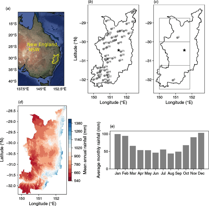
(a) Map of Australia showing the New England region of New South Wales, Australia, as defined for this study (background image from Google Earth); (b) the location of rainfall stations used in this study (full stations details provided in Supplementary Table S1); (c) the location of temperature stations used in this study, including representations of three HadEX3 gridboxes over New England; (d) the average annual rainfall over New England for 1981–2010 as calculated from Australian Gridded Climate Dataset (AGCD; Evans et al. 2020); (e) the monthly mean annual rainfall for 1981–2010 over New England calculated using AGCD. The location of ‘Eversleigh’ (Algernon Belfield’s residence) is shown with a star in (b) and (c).
Given the impact of this drought, and its conclusion that culminated in the Black Summer bushfires (Abram et al. 2021), there has already been extensive analysis of the event (Nguyen et al. 2021; Holgate et al. 2023; Devanand et al. 2024; Falster et al. 2024; Taschetto et al. 2024). However, most of these studies are at a multi-regional level covering several climate zones and many government electorates. For example, Taschetto et al. (2024) focus on the Murray–Darling Basin region in their assessment of the moisture source changes that occurred during the drought. The extensive review paper of Devanand et al. (2024) on the event centres on a similar region. Although these studies provide important context, hyperlocal studies are also useful for local communities and government.
The New England and North West regions of New South Wales boast substantial beef, cotton and wheat industries (Australian Bureau of Agricultural and Resource Economics and Sciences 2024). New England is home to 158,000 people (Australian Bureau of Statistics 2024), and the area provides ~20% of New South Wales’ agricultural GDP (New South Wales Department of Planning 2024). Despite this importance, no extended published drought climatology exists for the New England region. Providing detailed information about the past climate of this area is therefore vital to support informed agricultural planning and decision making.
Thankfully, there are several datasets of monthly rainfall totals for eastern Australia that extend to the mid-19th Century and include stations in New England (e.g. Gergis and Ashcroft 2013; Timbal and Fawcett 2013; Ashcroft et al. 2014; Evans et al. 2020). We are also fortunate to have a 19th Century dataset for New England that can provide extra information about daily temperature and rainfall variations. A grazier, Algernon Belfield, kept weather diaries at his property ‘Eversleigh’, outside Armidale, from 1877 until shortly before his death in 1922 (Thornton et al. 2018). The diaries provide an almost continuous record of 09:00-hours temperature, rainfall, pressure and wind observations for 44 years, as well as other meteorological variables including cloud cover and wet bulb temperature (Bridgman et al. 2019). Richard Belfield and his wife Elspeth recognised the value of the meteorological journals of Richard’s grandfather, and shared the diaries with the University of New England and University of Newcastle in 2009. Thanks to a citizen science effort to transcribe the diaries (Bridgman et al. 2019), Belfield’s efforts are now available to explore historical Australian climate variability.
This extension of the New England climate record into the 1800s is valuable for understanding multidecadal rainfall signals because the late 19th and early 20th Centuries were a time of large climate variability in Australia (Gergis and Ashcroft 2013). Several flooding events occurred in the 1870s and 1890s, the Centennial Drought decimated regions in 1888 (Nicholls 1997; Ritman and Ashcroft 2020), and the Federation Drought dominated from 1895 to 1903, all before the strongest signal of atmospheric warming began (Australian Bureau of Meteorology and CSIRO 2024).
In this paper, we make use of Belfield’s diary in conjunction with other observations and gridded datasets to build a detailed climatology of meteorological drought across New England, New South Wales, from 1880 to 2022. In Section 2, we describe the datasets used, as well as how we identified major drought events over the past 140 years. In Sections 3 and 4, we examine the characteristics of the droughts identified, including the details of daily temperature and rainfall events, to determine if different drought characteristics can be seen over time across the region. Finally, in Section 5, we compare our climatology with the behaviour of large-scale circulation features that are known to affect Australia’s climate to explore the role of remote influences on New England’s droughts.
2Data and methods
We use a range of datasets in this study to identify and examine New England meteorological droughts (Table 1). In addition to Belfield’s diary, which provides daily-scale temperature and rainfall information for the mid- to late 19th Century, we also use daily weather station data, monthly rainfall totals from a national gridded product and pre-calculated extreme indices from an international dataset.
| Dataset | Variable | Data range | Temporal resolution | Reference | |
|---|---|---|---|---|---|
| Australian Gridded Climate Dataset (AGCD) | Rainfall totals | 1880–2022 | Monthly | Evans et al. (2020) | |
| Bureau of Meteorology rainfall stations (53 across New England) | Rainfall totals | 1880–2022 | Daily | Bureau of Meteorology | |
| Australian Climate Observation Reference Network–Surface Air Temperature version 2 (ACORN-SAT) | Maximum and minimum temperature | 1910–2022 (Inverell, station number 056242) 1965–2022 (Scone, station number 061363) | Daily | Trewin et al. (2020) | |
| 1965–2024, Scone, station number 061363 | Daily | Trewin et al. (2020) | |||
| Weather diaries of Algernon Belfield | Maximum and minimum temperature, rainfall, quantitative remarks on snow | 1880–1922 | Daily | Bridgman et al. (2019) | |
| HadEx3 climate extreme dataset | 14 extreme temperature and rainfall indices (Table 2) | 1912–2016 | Daily | Dunn et al. (2020) | |
| Armidale snowfall | Counts of snowfall events in Armidale | 1957–2022 | Annual | Burr (2023) |
2.1 Defining New England droughts using the Australian Gridded Climate Dataset
To identify droughts for New England, we used monthly rainfall totals from the Australian Gridded Climate Dataset (AGCD; Evans et al. 2020). AGCD became the Australian Bureau of Meteorology’s operational monthly gridded rainfall product in September 2020, replacing the Australian Water Availability Project (AWAP, Jones et al. 2009). One key difference between AGCD and AWAP is that AGCD makes use of third-party data from farmers and rural organisations as well as official Bureau of Meteorology rainfall observations (Evans et al. 2020). Much of the third-party data are from New South Wales, which includes our study area. An updated analysis scheme as well as greater inclusion of quality control results and procedures also mean AGCD provides 1- × 1-km resolution data (compared with AWAP’s 5- × 5-km resolution data), with a reduction in interpolation errors and biases (Evans et al. 2020).
In south-eastern Australia, there is sufficient station coverage to reliably capture monthly rainfall variability since 1880 (Evans et al. 2020), compared with 1900 for the rest of Australia. We have also shown the AGCD is capable of accurately representing historical drought events (Ritman and Ashcroft 2020). Therefore, we extend our monthly drought analysis from 1880 to 2022.
There are many definitions of ‘New England’ (Atkinson 2006). For the present study, we defined the region using the bounds of the electoral district (Australian Electoral Commission 2022). Similarly, there are many different types of drought (Dai 2011). Here, we are focussing on meteorological drought only (i.e. a lack of rainfall), rather than agricultural, economic or social drought events. Although defining droughts using precipitation alone can fail to capture long-lived impacts of particular events (Vicente-Serrano et al. 2010; Ault 2020), limited availability of evaporation soil moisture or extensive temperature data made it impossible to use other metrics such as the Standard Precipitation Evaporation Index (SPEI). Additionally, regional and international studies have shown high correlation between the 12-month Standard Precipitation Index (SPI) and SPEI, which is the time scale we have used (Vicente-Serrano et al. 2010; Ojha et al. 2021; Nwayor and Robeson 2024).
Using the arithmetic regional mean, we calculated the 12-month SPI (McKee et al. 1993) to identify droughts from 1880 to December 2022. We tested 6- and 24-month SPI calculations, but settled on 12 months as this length captured a manageable number of events as well as the dominant droughts that could have caused agricultural impact. SPI was calculated using the Python package SPEI (ver. 0.4.2, see https://github.com/martinvonk/SPEI/tree/v0.4.2; Vonk 2025).
Following McKee et al. (1993), our drought events begin when the SPI first becomes negative as it progresses to a value of −1.0 or less. The drought is considered to have ended when the SPI returns to a positive value after reaching a value lower than −1.0 or less. We combined two droughts if they were less than 6 months apart, and ignored droughts shorter than 6 months in length. We then used length and intensity to categorise the droughts by severity. The measure of drought intensity (DI) was defined as the accumulated SPI value (or drought magnitude) divided by the length of the drought in months (n).
A drought was considered weak if the DI value was 1 s.d. below the mean, severe with a DI of 1 s.d. above the mean and moderate if it fell between these thresholds (mean = 0.89 in our case, s.d. = 0.32, threshold for weak = 0.57, threshold for severe = 1.21). We considered a drought to be short if it was fewer than 12 months in length, long if it persisted for more than 36 months and of medium length if it fell within these bounds.
New England receives more rainfall during the warm half of the year than the cool half (Fig. 1e) and studies suggest a drying trend is emerging in the wider region during austral winter in conjunction with a wetting trend during austral summer (e.g. Dey et al. 2019). To explore this trend during drought, we also looked at the seasonal timing of the rainfall in each event. If 4 of the 6 cool season months (April–September) or warm seasons months (October–March) experienced negative precipitation anomalies relative to the 1981–2010 mean, we considered the drought to be cool or warm season. Using this definition, droughts were able to be characterised by rainfall anomalies in both seasons, or neither, if fewer than 4 out of the 6 months for both half years experienced negative anomalies.
2.2 Daily rainfall and temperature observations
To explore daily rainfall and temperature indices as well as supplement the monthly AGCD gridded results, we draw on a selection of observational and gridded products of daily data. We use observational station data to assess daily rainfall variations during drought, rather than the AGCD dataset, as we only have access to monthly AGCD data for the pre-1900 period. Additionally, gridded datasets are known to underestimate extreme daily rainfall events, particularly in regions where station coverage varies over time (Tozer et al. 2012; King et al. 2013; Contractor et al. 2015).
We selected stations in the New England region from the Australian Bureau of Meteorology’s network with (a) more than 90 years of data; (b) at least 80% data coverage for the 1981–2010 base period; (c) fewer than 15 years with less than 80% of data available. To ensure coverage to the present, we also combined records for locations where stations had been moved or replaced (Supplementary Table S1). Data from the new station were taken as soon as quality-controlled data became available, to avoid potential data quality issues at the end of the older station’s life (Trewin 2010). All locations with overlapping data between old and new station locations were highly correlated on the monthly scale (R > 0.9). The Belfield rainfall record was also included in our analysis. In total, this led to a network of 53 locations with daily precipitation data (Fig. 1b, Supplementary Table S1).
Exploring long-term daily temperature variations over New England is more difficult than rainfall, as there are not many high-quality stations with daily data extending to the 19th Century (Trewin et al. 2020). Here, we make use of data from version 2.0 of the Bureau of Meteorology’s Australian Climate Observations Research Network–Surface Air Temperature (ACORN-SAT) dataset (Trewin et al. 2020) for Inverell (number 056242) and Scone (number 061363), both of which sit just inside the electoral district of New England (Fig. 1c). The data for these stations span 1910–present and 1965–present respectively.
We also use Belfield’s weather diaries, which provide almost complete 09:00-hours observations from 21 June 1877 to 30 June 1922 at ‘Eversleigh’, a property near Armidale (Fig. 1b, c). The quality assessment of Bridgman et al. (2019) found most variables recorded by Belfield were of sufficient quality for climate analysis. There was minimal bias in the rounding of the individual daily observations, very few nonsensical values and good agreement between related variables such as temperature and rainfall, and rainfall and cloud cover (Bridgman et al. 2019). There is, however, a strong warming trend in the minimum temperature observations that could not be fully explained by climate variability. This may be due to a change of instrument exposure, or a variation in the ground cover underneath the thermometer enclosure. Belfield’s minimum temperature data are therefore treated with caution. In this analysis, we supplement his quantitative data with remarks made in his diaries.
2.3 Climate extremes during drought events
To further examine the meteorological characteristics of each drought, we used a selection of extreme temperature and rainfall indices developed by the World Meteorological Organisation’s Expert Team on Sector-specific Climate Indices (Alexander and Herold 2016). We selected some absolute indices to help with the identification of extreme hot or cold events, but other relative indices to allow a comparison between stations (Table 2). We also calculated the number of Cotton Degree Growing Days during each drought (Table 2), given cotton’s importance as an agricultural commodity in the region.
| Precipitation indices | ||
|---|---|---|
| Total precipitation | The total amount of precipitation (mm) recorded | |
| Number of rain days | The total number of days when recorded rainfall was ≥1 mm | |
| Number of 95th percentile rain days | Number of rain days in the 95th percentile, relative to base period | |
| Simple Daily Intensity Index (SDII) | Amount of total precipitation (mm) divided by the number of rain days | |
| Cumulative Dry Days (CDD) | Maximum number of consecutive days when precipitation is <1 mm | |
| Cumulative Wet Days (CWD) | Maximum number of consecutive days when precipitation is >1 mm | |
| Temperature indices | ||
|---|---|---|
| Number of frost days | Number of days when minimum temperature is <0°C | |
| Cotton growing degree days (GDD) | A growing index to indicate conditions conducive to crop development, defined as: | |
| where Tx and Tn represent maximum and minimum temperature respectively (Constable and Shaw 1988) | ||
| Number of cold nights | Number of days when minimum temperature is in the 10th percentile | |
| Number of cold days | Number of days when maximum temperature is in the 10th percentile | |
| Number of warm nights | Number of days when minimum temperature is in the 90th percentile | |
| Number of warm days | Number of days when maximum temperature is in the 90th percentile | |
| Number of snow days | Number of days when snowfall is mentioned in Belfield’s diary or historical records of drought | |
Base period is 1981–2010 for all stations and gridpoints, except the Belfield record, when 1977–1922 is used. Percentiles for extreme day and night temperature indices were calculated using the Climdex Climpact software (ver. 3.3, see https://www.climdex.org/learn/tools/) according to methods outlined in Zhang et al. (2005), where the percentiles are defined relative to a 5-day moving calendar window to reduce inhomogeneities.
We additionally made use of the gridded HadEx3 dataset of climate extreme indices. HadEx uses over 7000 temperature stations to provide a global gridded dataset of 17 indices of climate and climate extremes (Dunn et al. 2020). Three gridboxes from HadEx cover the New England region (Fig. 1c), and the indices for these are used as additional ‘stations’ when exploring changes in extremes. We acknowledge that these gridded data products are not independent of the station data, as HadEx3 uses ACORN-SAT version 2 data to represent Australian temperature variability (Dunn et al. 2020). However, the gridding method used to develop HadEx3 would likely mean some input from neighbouring stations outside of the New England region, allowing us to capture a more complete picture of regional variability.
Finally, to provide an independent identification of cold extremes, we used Belfield’s snowfall remarks to identify snow events from 1877 to 1922 and compare those with settling and non-settling snow events in Armidale from 1957 (Burr 2023). We attempted to use Belfield’s remarks about frost as well, but found only 17 comments about the phenomenon in his records. This is much less than the number of potential frost days identified using his instrumental data, and not likely to be accurately capturing frost occurrence, so these remarks were not considered further.
2.4 Large-scale circulation features
Rainfall variability in inland New South Wales is influenced by a range of large-scale atmospheric and oceanic circulation features (Risbey et al. 2009). To explore the impact of these features on New England drought, we used indices for monthly to decadal variability in the Indian, Pacific and Southern Ocean regions (Table 3).
| Name | Start date | Source | Monthly rainfall correlation | Cool season rainfall correlation | Warm season rainfall correlation | |
|---|---|---|---|---|---|---|
| Subtropical Ridge Intensity (STR-I) | 1890 | Pepler et al. (2018) and A. Pepler, Australian Bureau of Meteorology, pers. comm. | −0.38 | −0.33 | 0.06 | |
| Subtropical Ridge Position (STR-P) | 1890 | Pepler et al. (2018) and A. Pepler, Australian Bureau of Meteorology, pers. comm. | 0.36 | 0.03 | 0.28 | |
| Southern Oscillation Index (SOI) | 1866 | Ropelewski and Jones (1987), Australian Bureau of Meteorology (2025a) | 0.23 | 0.45 | 0.47 | |
| Niño 3.4 index from HadISST1 | 1870 | Rayner et al. (2003) | −0.17 | −0.36 | −0.47 | |
| Gayndah–Deniliquin Index (GDI) | 1893 | Rakich et al. (2008) | 0.16 | 0.02 | 0.42 | |
| Southern Annular Mode (SAM) | 1957 | Marshall (2003) | 0.14 | 0.05 | 0.31 | |
| Indian Ocean Dipole Dipole Mode Index (DMI) | 1870 | Saji and Yamagata (2003), NOAA Physical Sciences Laboratory (2024) | −0.08 | –0.35 | −0.09 | |
| Interdecadal Pacific Oscillation (IPO) (annual) | 1854 | Henley et al. (2015) | −0.16 | −0.27 | −0.53 |
Correlations between these indices and New England’s annual cool season (April–September) and warm season (October–March) rainfall are also shown for the overlapping period between the rainfall data (1880 to 2022) and the index. All indices are monthly unless indicated, but correlations calculated using cool and warm season averages. Non-significant correlations (P > 0.05) are given in italic.
3Droughts in New England, 1880–2020
Thirty-two droughts were identified over the past 142 years (Fig. 2, Table 4), from 7 months (February to August 2019) to 89 months (July 1935–December 1942). This total does not include two droughts of 5 months (August–December 2000, October 2012–February 2013), which were removed from analysis to enable a focus on longer events.
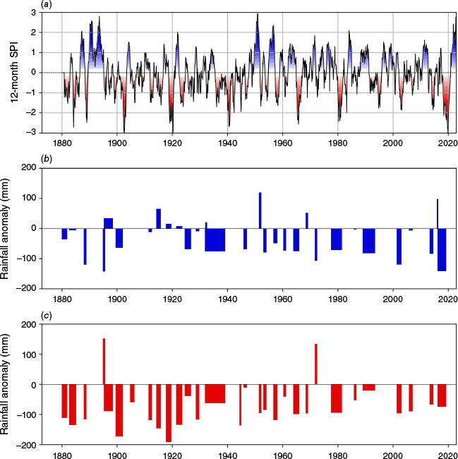
(a) SPI12 values for New England, New South Wales, Australia, January 1880–December 2022; (b) cool season (April–October) and (c) warm season (November–March) rainfall anomalies (mm) during each of the 32 identified droughts. Anomalies are relative to 1981–2010 mean.
| Start date | End date | Length (months) | Intensity | Duration type | Intensity type | Season anomaly | |
|---|---|---|---|---|---|---|---|
| 1880–12 | 1882–12 | 25 | 0.92 | Medium | Moderate | Both | |
| 1883–12 | 1886–06 | 30 | 1.02 | Medium | Moderate | Both | |
| 1888–06 | 1889–06 | 13 | 1.46 | Medium | Severe | Both | |
| 1895–04 | 1896–02 | 11 | 0.73 | Short | Moderate | Cool | |
| 1896–11 | 1900–02 | 35 | 0.56 | Medium | Weak | Warm | |
| 1900–10 | 1903–06 | 33 | 1.24 | Medium | Severe | Both | |
| 1905–07 | 1907–02 | 20 | 0.65 | Medium | Moderate | Warm | |
| 1912–01 | 1913–04 | 16 | 1.06 | Medium | Moderate | Both | |
| 1915–01 | 1916–09 | 21 | 0.87 | Medium | Moderate | warm | |
| 1918–09 | 1920–09 | 25 | 1.79 | Medium | Severe | Warm | |
| 1922–07 | 1924–10 | 28 | 0.98 | Medium | Moderate | Warm | |
| 1925–09 | 1928–01 | 29 | 0.68 | Medium | Moderate | Both | |
| 1929–03 | 1930–06 | 16 | 0.44 | Medium | Weak | Both | |
| 1932–04 | 1932–12 | 9 | 0.92 | Short | Moderate | Neither | |
| 1935–07 | 1942–11 | 89 | 0.92 | Long | Moderate | Both | |
| 1944–09 | 1945–05 | 9 | 0.98 | Short | Moderate | Warm | |
| 1946–06 | 1947–09 | 16 | 0.80 | Medium | Moderate | Both | |
| 1951–11 | 1952–09 | 11 | 1.02 | Short | Moderate | Warm | |
| 1953–08 | 1954–10 | 15 | 0.79 | Medium | Moderate | Both | |
| 1957–05 | 1958–11 | 19 | 1.12 | Medium | Moderate | Both | |
| 1960–10 | 1961–11 | 14 | 0.62 | Medium | Moderate | Both | |
| 1964–12 | 1967–02 | 27 | 1.33 | Medium | Severe | Both | |
| 1968–10 | 1969–09 | 12 | 0.38 | Medium | Weak | Warm | |
| 1972–02 | 1973–01 | 12 | 0.61 | Medium | Moderate | Cool | |
| 1979–07 | 1983–06 | 43 | 1.05 | Long | Moderate | Both | |
| 1986–04 | 1987–02 | 11 | 0.46 | Short | Weak | Both | |
| 1991–04 | 1995–10 | 55 | 0.68 | Long | Moderate | Both | |
| 2002–03 | 2003–12 | 22 | 1.10 | Medium | Moderate | Both | |
| 2006–06 | 2007–11 | 18 | 0.52 | Medium | Weak | Both | |
| 2013–12 | 2015–04 | 17 | 1.07 | Medium | Moderate | Both | |
| 2016–02 | 2016–08 | 7 | 0.65 | Short | Moderate | Neither | |
| 2017–09 | 2020–11 | 39 | 1.51 | Long | Severe | Both |
A drought is considered short if it was less than 12 months in length, long if it was over 36 months in length, and medium otherwise. A drought is considered weak if its intensity value was 1 s.d. below the mean, severe with an intensity of 1 s.d. above the mean, and moderate if it fell between these thresholds. Long or severe droughts are in bold. Seasonal anomalies used to calculate timing of rainfall deficits are relative to the 1981–2010 mean.
The distribution of the length and intensity of the droughts (Fig. 3) shows the average drought length to be 23 months, with four droughts lasting longer than 3 years. Five droughts were categorised as short, and four as long. Five droughts were categorised as weak, and five as severe. The ‘weakest’ drought using our method was October 1968–September 1969, and the most severe drought the 25-month event from September 1918 to September 1920. The Tinderbox Drought (September 2017–November 2020) was the second most severe using our DI metric, and the only event to be considered both long (>36 months) and severe by our definitions. Rainfall deficits are apparent across both cool and warm seasons.
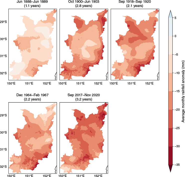
Maps showing the spatial pattern of each severe drought in New England as captured by our definition, in average monthly rainfall anomaly (mm) relative to 1981–2010 mean. Maps of all droughts are shown in Supplementary Fig. S1.
The 1880s experienced two moderate and one severe drought, with wet years towards the end of the decade punctuated by the short but damaging Centennial Drought from June 1888 to June 1889 (Nicholls 1997; Ritman and Ashcroft 2020). The year 1888 was the driest year recorded by Belfield, and the third most severe drought overall, despite being only 13 months in length.
The wettest period in the New England record occurred in the 1890s, which gave way to prolonged drought at the turn of the century (Fig. 2a). According to our definition, the Federation Drought was broken into two separate events in New England with a short reprieve in 1900. The second half of the drought was classified as more severe than the first, in line with other studies of a wider south-eastern Australian region (Verdon-Kidd and Kiem 2009; Ashcroft et al. 2014). The first part of the Federation Drought was also dominated by warm season deficits, whereas the second experienced rainfall decreases in both warm and cool halves of the year.
Recovery from the Federation Drought was followed by regular weak and moderate meteorological droughts in the early part of the 1900s, before the severe event of 1918–1920. This drought was significant across much of Australia and the world, in response to a strong El Niño event (Giese et al. 2010). The 1918–1920 event is the only severe event in the record dominated only by warm season rainfall deficits whereas other severe droughts are classified as year-round droughts. Four more droughts were then experienced between 1922 and 1932. The prolonged World War II Drought that followed soon after is the longest in the record (89 months) and was also associated with rainfall deficits in the warm and cool season, although it was only classified as moderate in its intensity using our metric (Table 4, Fig. 2b).
After the World War II (WWII) Drought, the middle part of the 20th Century saw high variability, with very wet periods punctuated by droughts of ~2 years or less. After severe drought from December 1964 to February 1967, the late 1960s and 1970s were comparatively wet, with only two weak droughts. However, the decade finished with a descent into drought. The well-known 1982–1983 drought that affected much of eastern Australia (Zillman 2001; Australian Bureau of Meteorology 2024) is classified as beginning in 1979 in New England.
Another break in drought conditions occurred for the rest of the 1980s, with only a weak drought identified from April 1986 to February 1987. A long drought then afflicted the region from 1991 to 1995. This drought was the second longest to be experienced in the region, at 55 months, and although the SPI anomalies are not as intense as the 1920s, 1980s, or recent events, the length of the 1990s drought ensured its classification as moderate rather than weak in our analysis.
The widespread dry conditions that affected much of eastern Australia at the turn of the 20th to 21st Century, now known as the Millenium Drought (van Dijk et al. 2013), does not appear as pronounced in the New England region. This result is in keeping with national analyses that show the Millenium Drought largely spared the north-east inland areas of New South Wales (e.g. Verdon-Kidd and Kiem 2009). Two droughts during that period show up using our approach: a 22-month drought in 2002 and 2003, and weaker drought from June 2006 to November 2007. However, it is worth noting there are no periods of extreme above-average rainfall during this time (Fig. 2a), which means the moderate droughts could still have had significant impacts.
New England only spent 24 months out of drought between December 2013 and the end of 2020, with three events identified in the past decade. The Tinderbox Drought is the second most severe event in 142 years after the 1918–1920 drought using our severity calculation that considers SPI magnitude and event length. It is also the only drought to be considered both severe and long. Cool season rainfall anomalies are also greater during the Tinderbox Drought than in any other event in the past 140 years.
Splitting the rainfall into cool and warm season suggests the type of drought has changed over the past 130 years (Fig. 2b, c). We see the shift from warm season droughts to cool season droughts that has been reported elsewhere for wider regions (Nguyen et al. 2015; Australian Bureau of Meteorology and CSIRO 2024). Although there are rainfall deficits during the warm season in recent events, no drought has been driven by only warm season anomalies in the last 50 years.
3.1 Spatial patterns of severe droughts across New England
Unsurprisingly, the spatial patterns of rainfall deficits during the severe droughts all show negative anomalies across the entire region (Fig. 3). However, each drought has a different spatial footprint. The shorter 1888 drought shows the greatest anomalies in the north-east, central west and south-east regions of New England. The second half of the Federation Drought from 1900 to 1903 was most severe along the lower and climatologically wetter eastern edge of the region, whereas the 25-month 1918–1920 drought was most severe in the south-east regions. Severe rainfall deficiencies from December 1964 to February 1967 were clustered to the south-east of the region as well as the west.
In contrast to these earlier severe events, the recent Tinderbox Drought saw some of its largest rainfall deficits in the central northern plateau, as well as a swathe across the centre of New England. These areas hold several population centres of New England, including Armidale, Glen Innes and Tenterfield (stations numbers 25, 31 and 37 in Fig. 1b). The footprints of the other droughts often had smaller deficits in this region.
No obvious trend emerges in the spatial patterns of the droughts (Fig. 3 for severe droughts, Supplementary Fig. S1 for all droughts). The spatial footprints vary between strong negative anomalies on the coastal side of the region – sometimes the entire length, and at other times pockets of the ridge – and the entire plateau, and this is apparent throughout the record. Droughts in the early 1800s, for example, show a similar easterly-dominated spatial signature to the 1986 and 1991 events. The western-dominated droughts of 1953–1954 and 1972 have a similar pattern, as do the consecutive south-easterly post-WWII droughts of 1944–1945 and 1946–1947.
3.2 Daily rainfall and temperature characteristics of droughts in New England
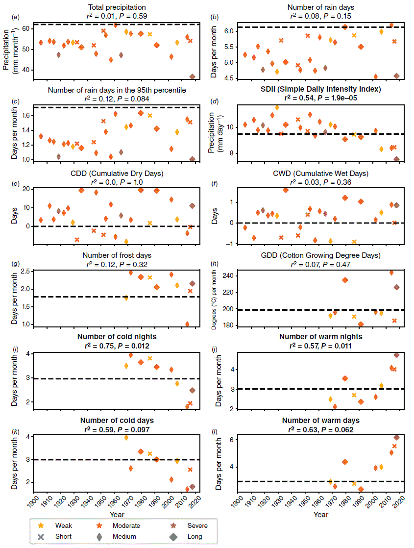
Examining daily temperature and rainfall indices during each drought, rather than seasonal totals and averages, allows us to explore the events in more detail. Statistics for each drought are shown in Supplementary Table S2, whereas Fig. 4 shows these results for droughts whose rainfall and temperature metrics were calculated with a largely constant data network. For rainfall, this applies to events after 1900 and for temperature, this applies to events after 1960.
(a–l) Mean drought metrics for drought events where the data network is largely constant (precipitation metrics included from 1900 to 2022 and temperature metrics included for 1960 to 2022). Colour scale indicates drought intensity: light, medium, dark corresponding to weak, moderate, severe. Shapes indicate drought duration: circle, triangle, square corresponding to short, medium, long. Dashed line indicates the climatology value over the 1981–2010 period. Bold titles indicate the observed trend is statistically significant. Also note that GDD is computed using ACORN-SAT data only. For comparison between drought events, which are of varying duration, daily weather indices for each drought are divided by the length of the drought event in months. This is performed on all indices excluding the SDII, CDD and CWD.
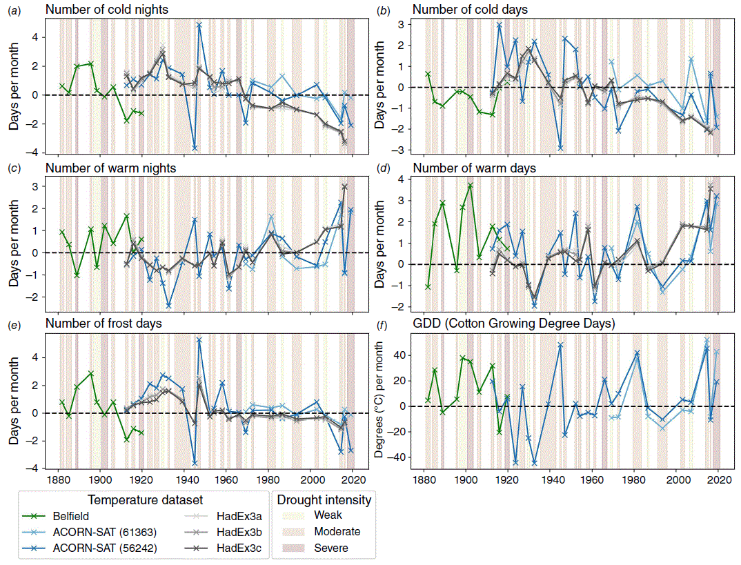
We also examined the temperature metrics of each station individually back to 1877 (Fig. 5) and found similar results. The individual stations show good agreement, although higher variability is clear in the individual station values compared with the HadEx3 gridpoint values. The Belfield record additionally shows consistently cooler than average cold day counts and a greater range of warm day counts compared with the ACORN-SAT totals. This difference may be a result of instrument exposure differences and the role of frost hollows, which can be significant in mountainous areas (e.g. Trewin 2005). The frost day and cold night counts from Belfield also deteriorate from the early 1900s, matching the unexplained trend in the full dataset (Bridgman et al. 2019).
(a–f) Extreme temperature index anomalies for each drought in New England, calculated for each station and HadEX3 grid cell. Drought periods and intensity are shown in the shaded bars: light yellow, light orange, light red corresponding to weak, moderate, severe events. Anomalies are calculated relative to the mean of each dataset, rather than the same base climatology. Values of the mean for each dataset and index are provided in Supplementary Table S3.
Droughts are unsurprisingly associated with a below-average number of rain days and extreme rainfall events. The Tinderbox Drought recorded the lowest value for most rainfall metrics examined: mean total monthly rainfall, number of rain days, number of extreme rain days and the amount of rain recorded during each rain event (Simple Daily Intensity Index, SDII). In fact, we see a moderate but statistically significant decrease in SDII during droughts since 1900, associated with a combination of increasing rain days and decreasing total rainfall (Fig. 4a–c). This trend is clear regardless of the length or intensity of the drought. In contrast, no statistically significant trend arises when considering all years, both drought and non-drought (not shown).
Longer droughts are associated with a higher number of consecutive dry days, with the Federation Drought and 1980s drought both showing over 50 dry days in a row, averaged across the station network. Severe droughts, however, are not distinguishable by their number of consecutive dry days, but by the lack of extreme rainfall days (Fig. 4c). This finding agrees with the results of Parker and Gallant (2022), who showed that a small number of extreme rainfall days can make or break droughts across Australia.
The temperature result in Fig. 4 and 5 indicate droughts in New England over the last 142 years are associated with greater than average occurrences of frosts and cold nights, fewer warm nights and more warm days. These results are to be expected: a decrease in rainfall and cloud cover would lead to enhanced radiative cooling overnight and greater warming from solar insolation during the day (Jones and Trewin 2000).
However, our findings also show that this relationship has eroded over the past 20–30 years, particularly in relation to cold nights. Both cold and warm temperature extremes show a statistically significant trend over the chosen period (R2 > 0.5 and P ≤ 0.05). Warm temperature extremes during drought events are increasing in frequency, while cold temperature extremes are becoming less frequent. This result is in line with regional temperature trends generally and specifically during dry periods (Nicholls 2004; Jakob and Walland 2016; Australian Bureau of Meteorology and CSIRO 2024).
The number of cold nights recorded in droughts during the 21st Century is less than the climatological average of all years during the base period, not just drought years. This result is particularly noteworthy given the trend towards more cool season droughts in New England. If the drying trend is greatest in the cooler part of the year, this would logically lead to more clear nights in those seasons, meaning an even greater chance of absolute cold temperatures.
The one exception to this observed breakdown between cold extremes and meteorological drought is snowfall. Comparing Belfield’s snow remarks for 1877–1922 with observations taken in Armidale from 1957 to 2022 (Supplementary Tables S4 and S5), we found the average number of snow days per year was different between the datasets: 2.87 snow events per year for Belfield compared with 1.97 for Armidale. The lower snow occurrence in Armidale compared with ‘Eversleigh’ is likely due to the slightly lower altitude of Armidale and increased temperatures in the recent period.
However, although the absolute snowfall totals were different in Belfield’s records and in nearby Armidale, the relationship between snowfall events during and outside drought periods was similar. In other words, a similar number of snow events were seen across each record whether the region was in drought or not. This preliminary analysis suggests the cold outbreaks responsible for snowfall in New England do not vary greatly during drought, although further exploration is needed to test the significance of this finding.
4Relationship between New England droughts and large-scale climate indices
Previous studies have repeatedly linked drought behaviour over inland New South Wales to a combination of the El Niño–Southern Oscillation (ENSO) and the Indian Ocean Dipole (IOD) (e.g. Risbey et al. 2009; Ummenhofer et al. 2011; Devanand et al. 2023; Falster et al. 2024). But can this relationship also be seen over a smaller region, and further back in time?
Correlations between the extended New England rainfall record and large-scale circulation indices are generally strongest during the warm season (Table 3). The Southern Annular Mode (SAM), the Interdecadal Pacific Oscillation (IPO), both atmospheric and oceanic component of ENSO and the position of the subtropical ridge (STR-P) all show moderate but significant correlations with October to March rainfall. The Niño 3.4 index and SOI show weaker, but still significant correlations during the cool season, whereas the Dipole Mode Index (DMI, a measure of the Indian Ocean Dipole, IOD) and intensity of the STR (STR-I) are also significantly correlated during April to September.
Comparing the drought events with large-scale circulation features over our extended period (Fig. 6) shows a similar relationship to analyses over larger regions or shorter time scales. The longest and most severe droughts in our record are associated with El Niño conditions, a positive IPO phase and a negative phase of the IOD. The short 1888 Centennial Drought stands out in particular as the event associated with the most negative IPO phase and Niño 3.4 index value in our climatology. The Tinderbox Drought was associated with the most extreme DMI value, greater than 0.75, where the next greatest value is below 0.5. The recent drought is also associated with a significant drop in the SAM, which has been showing a positive trend in austral summer since the 1960s (Marshall 2003; Fogt and Marshall 2020).
Comparative plot of droughts identified for New England, along with the annual rainfall in New England (a), variations in the Southern Annular Mode (b), the Dipole Mode Index, representing variations in the Indian Ocean Dipole (c), the variations in subtropical ridge intensity and precipitation (d) and variations in the El Niño–Southern Oscillation and Interdecadal Pacific Oscillation (e). Full details of indices and abbreviations are provided in Table 3. Length of each drought is given by the width of the shaded bars, and the colours indicate the severity of the drought: light green, light red, dark red corresponding to weak, moderate, severe.
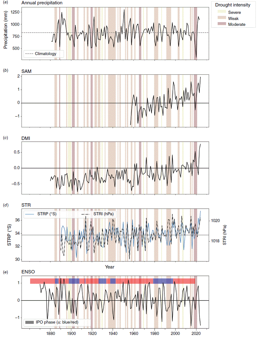
Put another way, there is a lack of La Niña or negative IPO events during long droughts, which could be seen as an absence of drought-breaking rains (King et al. 2020; Devanand et al. 2023). However, no strong relationship emerges between any of the drivers and the extreme indices within the droughts that we can see, e.g. an ENSO-driven drought is not related to an increase or decrease in rain days compared with a drought associated with an IPO phase (not shown).
Droughts associated with rainfall deficits in the warm season only are associated with weaker than average STR-I, with the five weakest STR-I values in our climatology all occurring during warm season-only events. For shorter droughts that only span the warmer months of the year (e.g. September 1944 to May 1945), this result may simply be picking up the seasonal cycle of the STR, as the ridge pressure is usually weakest from November to March (Timbal and Drosdowsky 2013). However, the remaining droughts span multiple years including cool seasons, suggesting there may have been a persistent weakening of the ridge for these events. It is also worth noting the one drought with a strongly positive STR-I value and rainfall deficits in the warm season alone is the 1918–1920 event, the most severe in our record.
Finally, we do not see any strong relationship between the identified droughts and indices that represent variations in extratropical winds. The Gayndah–Deniliquin Index (GDI), which captures the strength of onshore winds in eastern Australia (Rakich et al. 2008), shows only moderately positive values during the longest and most extreme droughts (not shown). Additionally, SAM values during these events are inconsistent: the recent drought was associated with a sharp drop in SAM, whereas the 1960s severe drought was associated with a relative increase (Fig. 6). A longer SAM index or updated GDI index may uncover a stronger link, but this overarching comparison suggests a dominant phase of the mid-latitude flow alone cannot be used to estimate the strength of a drought in New England.
5Discussion
Our climatology of meteorological droughts in New England has identified 32 events in the 142 years from 1880 to 2022. Of these events, we classify five as severe and four as long. Although the recent Tinderbox Drought is not the longest or most severe by our definitions, it is the only event that is classified as both long and severe. The recent drought is also the driest in terms of average rainfall days per month, number of extreme rainfall days, rainfall anomaly during the cool season and total rainfall amount per month. These results confirm that by most precipitation metrics, the Tinderbox Drought was unprecedented in the New England region over the past 142 years.
The Tinderbox Drought was also associated with the largest anomaly in cool season rainfall in New England, reflecting the shift towards drier cool seasons observed across much of southern Australia (McKay et al. 2023; Australian Bureau of Meteorology and CSIRO 2024). This shift is captured in our identified New England droughts, with warm season rainfall deficits dominating events in the early part of the records and cool season rainfall deficits dominating events from the 1950s. There has not been a warm season-only drought in New England in the past 50 years. The shift towards drier cool seasons may be good news for the cotton industry, as the cotton season occurs from September to March (Department of Agriculture, Fisheries and Forestry 2019). However, given the importance of cool season rainfall to other crop success, landscapes, waterways and soil health (e.g. Pook et al. 2009; Speer et al. 2021; Churchill et al. 2022), there are more negative effects to be considered.
The seasonal shift in drought occurrence is also likely captured in the downward trend of rainfall intensity (SDII) we identified during drought events since 1880. This trend results from both a decrease in total rain and an observed increase in the number of rain days, suggesting fewer heavy rainfall events and more days of small totals. This shift may represent the identified decrease in the number of large synoptic systems delivering large totals across eastern Australia in the cooler months (Pook et al. 2009; Contractor et al. 2018; Pepler 2020; McKay et al. 2023). Broader analysis shows a decreasing trend in the SDII in New England overall, whether or not a drought is present (Australian Bureau of Meteorology 2025b), alongside large spatial variability of the magnitude and sign of the trend throughout broader New South Wales.
The recent Tinderbox Drought was additionally associated with the highest number of warm days and warm nights over the past 60 years using our full dataset. Examining longer temperature records from individual stations suggests the Tinderbox Drought was the hottest since 1880, reflecting background warming trends. Below-average counts of cold days and nights were also observed during the Tinderbox Drought compared with other droughts, further illustrating with the clear warming signal.
Although we did see a decrease in cold days and nights during drought in New England since 1880, we did not find a significant decrease in the number of frost days. A similar pattern has been observed in frost events in southern Australia, where a small increase in frost occurrence has been observed (Dittus et al. 2015; Crimp et al. 2016). This result is likely associated with the shift towards cool season drying across eastern Australia. If this cool season drying persists (as many studies suggest), there may be opposing forces acting on cold temperatures in New England during drought: the warming influence of climate change counteracting the cooling effect caused by fewer clouds to trap outgoing longwave radiation overnight.
Regional projection studies for southern Australia have indicated frost risk is likely to remain the same, or possibly increase for at least the next decade before decreasing, noting that many models struggle to accurately capture current trends in extreme minimum temperature across the region (Crimp et al. 2018; Seneviratne et al. 2021). Given the impact of extreme overnight temperatures – both high and low – on agriculture, human and animal health and ecosystems, is it worthwhile exploring the extent of these opposing drivers over New England in future studies.
Our extended analysis also supports the findings of shorter studies over wider regions, which show the longest and most severe droughts are associated with multiple large-scale circulation features. Although no clear signal emerges from our analysis about a particular circulation feature dominating drought occurrence over New England, it is reassuring that the general relationship found in larger geographical studies is also captured in our regional analysis.
This study is the first to explore droughts in New England back to 1880. Most analyses for regional New South Wales either use a shorter time-period, or are larger in spatial extent, meaning that regional nuances can be overlooked. With this climatology, we can provide local councils, regional land managers and the New England community with information that is relevant to them. These kinds of hyperlocal studies are more often conducted for urban areas, despite regional areas being responsible for significant national contributions. New England, for example, produces 20% of New South Wales’ agricultural output (New South Wales Department of Planning 2024).
In addition to providing value for local industries, conducting focussed regional studies may also connect previously unengaged people with climate science and climate change. Quantitative and qualitative studies have found that scepticism around climate change is higher in regional and rural areas of Australia (Austin et al. 2020; Paas et al. 2024). Although media habits and political geography play a role in these findings (Colvin et al. 2024), one reason often given is that climate studies themselves are done in cities, without any consideration of regional knowledge or experience (Witt et al. 2009). Our hope with this study – which makes use of well-known historical weather data – is to not only provide detailed information for the people of New England, but show that local experience and history are a key piece of the story.
As well as being the first drought climatology for New England, this study also provides one of the first analyses of daily temperature and rainfall data for New England back to the late 19th Century. Exploration of historical extreme events on the daily scale are rare, owing to data availability and data quality (Gergis et al. 2020). As we have shown, care must be taken to use historical daily data, and extreme values cannot always be taken as reliable without close interrogation. However, as more observations are found and examined for quality, we are confident more studies into 19th Century weather variability (as opposed to climate variations) will be possible over Australia.
6Conclusions
In this study, we present the first climatology of meteorological droughts in New England, New South Wales, dating back to 1880 and extending to the recent Tinderbox Drought (2017–2019). Despite being shorter than other droughts in the climatology, the Tinderbox Drought stands out as the most extreme in terms of rainfall deficiencies and maximum temperature in 140 years. We have also identified a shift in the behaviour of droughts in this important region of inland Australia. Droughts over the past 50 years are more dominated by cool season rainfall deficiencies than droughts in the early part of the 20th Century.
The meticulous recovery and analysis of high-quality historical weather data are crucial for enhancing our understanding of historical weather and climate events. This effort not only provides a clearer picture of past climatic conditions but also places current changes into a long-term context. By continuing to improve the accuracy of historical climate records, we can better understand the trends and anomalies in modern weather data, thus informing more effective climate adaptation and mitigation strategies for regional areas.
Data availability
Observational temperature and rainfall data used in this study are available from the Australian Bureau of Meteorology (http://www.bom.gov.au/climate/data/acorn-sat/for temperature and http://www.bom.gov.au/climate/data/for rainfall). Gridded AGCD data from 1900 to 2022 are available from National Computing Infrastructure Australia (http://dx.doi.org/10.25914/6009600304b02). AGCD data from 1880 to 1899 were made available by the Australian Bureau of Meteorology for this study, and can be accessed by request to the organisation’s Climate Data Services portal (https://reg.bom.gov.au/climate/data-services/). HadEX3 data are available from the UK MetOffice, following the details available in Dunn et al. (2020). Images and transcriptions of Algernon Belfield’s diaries are available from the University of Newcastle, with full details available in Bridgman et al. (2019). Details of where to access indices of large-scale circulation features are provided in Table 3.
Declaration of funding
L. Ashcroft acknowledges The University of Melbourne’s Parental Leave Support Scheme, which funded the involvement of M. Ritman.
Dedication
This article is dedicated to Richard Belfield, who passed away during its preparation. Richard and his wife Elspeth have provided extensive knowledge of New England, and have been indefatigable in their commitment to share Algernon’s diaries with the world.
Acknowledgements
We acknowledge the support of the University of Newcastle Cultural Collections and University of New England Archives who were instrumental in saving, imaging and digitising the Belfield record. Many thanks to Alex Evans at the Bureau of Meteorology for access to the extended AGCD record, Acacia Pepler at the Bureau of Meteorology for the STR indices, and the Australian National Computational Infrastructure for access to AGCD and computing time. Many thanks also to the two anonymous reviewers whose comments improved the manuscript. L. Ashcroft acknowledges the support of the ARC Centre of Excellence for Climate Extremes, and The University of Melbourne’s Parental Leave Support Scheme.
References
Abram NJ, Henley BJ, Sen Gupta A, et al. (2021) Connections of climate change and variability to large and extreme forest fires in southeast Australia. Communications Earth & Environment 2, 8.
| Crossref | Google Scholar |
Alexander L, Herold N (2016) ClimPACT2. Indices and software. A document prepared on behalf of The Commission for Climatology (CCl) Expert Team on Sector-Specific Climate Indices (ET-SCI). (World Meteorological Organisation) Available at https://epic.awi.de/id/eprint/49274/
Ashcroft L, Karoly DJ, Gergis J (2014) Southeastern Australian climate variability 1860–2009: a multivariate analysis. International Journal of Climatology 34, 1928-1944.
| Crossref | Google Scholar |
Ault TR (2020) On the essentials of drought in a changing climate. Science 368, 256-260.
| Crossref | Google Scholar | PubMed |
Austin EK, Rich JL, Kiem AS, Handley T, Perkins D, Kelly BJ (2020) Concerns about climate change among rural residents in Australia. Journal of Rural Studies 75, 98-109.
| Crossref | Google Scholar |
Australian Bureau of Agricultural and Resource Economics and Sciences (2024) New South Wales: New England and North West. In ‘About my region dashboard’. (Tableau) Available at https://public.tableau.com/app/profile/australian.bureau.of.agricultural.and.resource.economics.and.sci/viz/shared/G5YGBK8XC [Verified 10 September 2025]
Australian Bureau of Meteorology (2020) Special Climate Statement 70 update—drought conditions in Australia and impact on water resources in the Murray–Darling Basin. (Commonwealth of Australia) Available at http://www.bom.gov.au/climate/current/statements/scs70.pdf
Australian Bureau of Meteorology (2024) Australian rainfall during El Niño and La Niña events. (ENSO Hist). (Commonwealth of Australia) Available at http://www.bom.gov.au/climate/history/enso/ [Verified 17 December 2024]
Australian Bureau of Meteorology (2025a) Southern Oscillation Index since 1876. (Commonwealth of Australia) Available at https://www.bom.gov.au/climate/enso/soi/ [Verified 15 February 2025]
Australian Bureau of Meteorology (2025b) Australian climate extremes – trend maps, simple daily intensity. (Commonwealth of Australia) Available at http://www.bom.gov.au/cgi-bin/climate/change/extremes/trendmaps.cgi?map=SDII&period=1900 [Verified 3 February 2025]
Australian Bureau of Meteorology and CSIRO (2024) State of The Climate 2024. (Commonwealth of Australia) Available at http://www.bom.gov.au/state-of-the-climate/2024/ [Verified 16 December 2024]
Australian Bureau of Statistics (2024) New England: 2021 Census All persons QuickStats. (ABS) Available at https://abs.gov.au/census/find-census-data/quickstats/2021/CED130 [Verified 11 December 2024]
Australian Electoral Commission (2022) Profile of the electoral division of New England (NSW). (AEC) Available at https://www.aec.gov.au/Elections/federal_elections/2022/profiles/nsw/new-england.htm [Verified 18 September 2025]
Barbour L (2019) Country towns close to reaching ‘day zero’, as water supplies dry up in the drought. In ABC News, 14 July 2019. Available at https://www.abc.net.au/news/2019-07-14/day-zero-approaching-as-towns-run-out-of-water/11271430
Bridgman H, Ashcroft L, Thornton K, Di Gravio G, Oates W (2019) Meteorological observations for Eversleigh Station, near Armidale, New South Wales, Australia: 1877–1922. Geoscience Data Journal 6, 174-188.
| Crossref | Google Scholar |
Burr P (2023) Snow in Armidale NSW. (published by the author) Available at https://www.weatherarmidale.com/snow.html [Verified 16 December 2024]
Churchill AC, Zhang H, Fuller KJ, et al. (2022) Pastures and climate extremes: impacts of cool season warming and drought on the productivity of key pasture species in a field experiment. Frontiers of Plant Science 13, 836968.
| Crossref | Google Scholar |
Colvin RM, Jotzo F, Fielding KS (2024) Is Australia’s urban–regional schism on climate reality or rhetoric?. Journal of Rural Studies 112, 103446.
| Crossref | Google Scholar |
Constable GA, Shaw AJ (1988) Temperature requirements for cotton. In AgFacts P5.3.5. (NSW Agriculture & Fisheries) Available at https://www.dpi.nsw.gov.au/__data/assets/pdf_file/0003/710796/Agfact-P5.3.5-Temperature-requirements-for-cotton.pdf
Contractor S, Alexander LV, Donat MG, Herold N (2015) How well do gridded datasets of observed daily precipitation compare over Australia? Advances in Meteorology 2015, 325718.
| Crossref | Google Scholar |
Contractor S, Donat MG, Alexander LV (2018) Intensification of the daily wet day rainfall distribution across Australia. Geophysical Research Letters 45, 8568-8576.
| Crossref | Google Scholar |
Crimp S, Jin H, Kokic P, Bakar S, Nicholls N (2018) Possible future changes in South East Australian frost frequency: an inter-comparison of statistical downscaling approaches. Climate Dynamics 52, 1247-1262.
| Crossref | Google Scholar |
Crimp SJ, Gobbett D, Kokic P, Nidumolu U, Howden M, Nicholls N (2016) Recent seasonal and long-term changes in southern Australian frost occurrence. Climatic Change 139, 115-128.
| Crossref | Google Scholar |
Dai A (2011) Drought under global warming: a review. Wiley Interdisciplinary Reviews. Climate Change 2, 45-65.
| Crossref | Google Scholar |
Department of Agriculture, Fisheries and Forestry (2019) Agriculture and land: Farming, food and rural support: Crops: Cotton. (Commonwealth of Australia) Available at https://www.agriculture.gov.au/agriculture-land/farm-food-drought/crops/cotton [Verified 30 January 2025]
Devanand A, Evans JP, Abramowitz G, Hobeichi S, Pitman AJ (2023) What is the probability that a drought will break in Australia? Weather and Climate Extremes 41, 100598.
| Crossref | Google Scholar |
Devanand A, Falster GM, Gillett ZE, et al. (2024) Australia’s Tinderbox Drought: an extreme natural event likely worsened by human-caused climate change. Science Advances 10, eadj3460.
| Crossref | Google Scholar |
Dey R, Lewis SC, Arblaster JM, Abram NJ (2019) A review of past and projected changes in Australia’s rainfall. Wiley Interdisciplinary Reviews. Climate Change 10, e577.
| Crossref | Google Scholar |
Dittus AJ, Karoly DJ, Lewis SC, Alexander LV (2015) An investigation of some unexpected frost day increases in southern Australia. Australian Meteorological and Oceanographic Journal 64, 261-271.
| Crossref | Google Scholar |
Dunn RJH, Alexander LV, Donat MG, et al. (2020) Development of an updated global land in situ-based data set of temperature and precipitation extremes: HadEX3. Journal of Geophysical Research: Atmospheres 125, e2019JD032263.
| Crossref | Google Scholar |
Evans A, Jones D, Smalley R, Lellyett S (2020) An enhanced gridded rainfall dataset scheme for Australia. Bureau Research Report BRR041. (Bureau of Meteorology, Climate Services: Melbourne, Vic., Australia) Available at http://www.bom.gov.au/research/publications/researchreports/BRR-041.pdf
Falster G, Coats S, Abram N (2024) How unusual was Australia’s 2017–2019 Tinderbox Drought? Weather and Climate Extremes 46, 100734.
| Crossref | Google Scholar |
Fogt RL, Marshall GJ (2020) The Southern Annular Mode: variability, trends, and climate impacts across the Southern Hemisphere. Wiley Interdisciplinary Reviews. Climate Change 11, e652.
| Crossref | Google Scholar |
Gergis J, Ashcroft L (2013) Rainfall variations in south-eastern Australia part 2: a comparison of documentary, early instrumental and palaeoclimate records, 1788-2008. International Journal of Climatology 33, 2973-2987.
| Crossref | Google Scholar |
Gergis J, Ashcroft L, Whetton P (2020) A historical perspective on Australian temperature extremes. Climate Dynamics 55, 843-868.
| Crossref | Google Scholar |
Giese BS, Compo GP, Slowey NC, Sardeshmukh PD, Carton JA, Ray S, Whitaker JS (2010) The 1918/19 El Niño. Bulletin of the American Meteorological Society 91, 177-183.
| Crossref | Google Scholar |
Henley BJ, Gergis J, Karoly DJ, Power S, Kennedy J, Folland CK (2015) A tripole index for the Interdecadal Pacific Oscillation. Climate Dynamics 45(11–12), 3077-3090.
| Crossref | Google Scholar |
Holgate CM, Pepler AS, Rudeva I, Abram NJ (2023) Anthropogenic warming reduces the likelihood of drought-breaking extreme rainfall events in southeast Australia. Weather and Climate Extremes 42, 100607.
| Crossref | Google Scholar |
Jakob D, Walland D (2016) Variability and long-term change in Australian temperature and precipitation extremes. Weather and Climate Extremes 14, 36-55.
| Crossref | Google Scholar |
Jones DA, Trewin BC (2000) On the relationships between the El Nino–Southern Oscillation and Australian land surface temperature. International Journal of Climatology 20, 697-719.
| Crossref | Google Scholar |
Jones DA, Wang W, Fawcett R (2009) High-quality spatial climate data-sets for Australia. Australian Meteorological and Oceanographic Journal 58, 233-248.
| Crossref | Google Scholar |
King AD, Alexander LV, Donat MG (2013) The efficacy of using gridded data to examine extreme rainfall characteristics: a case study for Australia. International Journal of Climatology 33, 2376-2387.
| Crossref | Google Scholar |
King AD, Pitman AJ, Henley BJ, Ukkola AM, Brown JR (2020) The role of climate variability in Australian drought. Nature Climate Change 10, 177-179.
| Crossref | Google Scholar |
Marshall GJ (2003) Trends in the Southern Annular Mode from observations and reanalyses. Journal of Climate 16, 4134-4143.
| Crossref | Google Scholar |
McKay RC, Boschart G, Rudeva I, et al. (2023) Can southern Australian rainfall decline be explained? A review of possible drivers. Wiley Interdisciplinary Reviews: Climate Change 14, e820.
| Crossref | Google Scholar |
McKee TB, Doesken NJ, Kleist J (1993) The relationship of drought frequency and duration to time scales. In ‘Proceedings of Eighth Conference on Applied Climatology’, 17–22 January 1993, Anaheim, CA, USA. pp. 179–184. (American Meteorological Society: Boston, MA, USA) Available at https://www.droughtmanagement.info/literature/AMS_Relationship_Drought_Frequency_Duration_Time_Scales_1993.pdf
New South Wales Department of Planning (2024) New England North West Regional Plan 2041, Economic development. (NSW Government) Available at https://www.planning.nsw.gov.au/plans-for-your-area/regional-plans/new-england-north-west-regional-plan-2041/economic-development [Verified 11 December 2024]
Nguyen H, Lucas C, Evans A, Timbal B, Hanson L (2015) Expansion of the Southern Hemisphere Hadley Cell in response to greenhouse gas forcing. Journal of Climate 28, 8067-8077.
| Crossref | Google Scholar |
Nguyen H, Wheeler MC, Hendon HH, Lim E-P, Otkin JA (2021) The 2019 flash droughts in subtropical eastern Australia and their association with large-scale climate drivers. Weather and Climate Extremes 32, 100321.
| Crossref | Google Scholar |
Nicholls N (2004) The changing nature of Australian droughts. Climatic Change 63, 323-336.
| Crossref | Google Scholar |
NOAA Physical Sciences Laboratory (2024) Dipole Mode Index (DMI) monthly time-series. (NOAA PSL: Boulder, CO, USA) Available at https://psl.noaa.gov/data/timeseries/month/DS/DMI/ [Verified 22 January 2025]
Nwayor IJ, Robeson SM (2024) Exploring the relationship between SPI and SPEI in a warming world. Theoretical and Applied Climatology 155, 2559-2569.
| Crossref | Google Scholar |
Ojha SS, Singh V, Roshni T (2021) Comparison of meteorological drought using SPI and SPEI. Civil Engineering Journal 7, 2130-2149.
| Crossref | Google Scholar |
Paas K, Bradley G, Deshpande S, Foxwell-Norton K, Mackey B (2024) Griffith Climate Action Survey 2023: Summary for Policy and Decision Making. (Griffith University) doi:10.25904/5S6N-S893
Parker T, Gallant AJE (2022) The role of heavy rainfall in drought in Australia. Weather and Climate Extremes 38, 100528.
| Crossref | Google Scholar |
Pepler A (2020) Record lack of cyclones in southern Australia during 2019. Geophysical Research Letters 47, e2020GL088488.
| Crossref | Google Scholar |
Pepler A, Ashcroft L, Trewin B (2018) The relationship between the subtropical ridge and Australian temperatures. Journal of Southern Hemisphere Earth Systems Science 68(1), 201.
| Crossref | Google Scholar |
Pook MJ, Lisson S, Risbey JS, Ummenhofer CC, McIntosh PC, Rebbeck M (2009) The autumn break for cropping in southeast Australia: trends, synoptic influences and impacts on wheat yield. International Journal of Climatology 29, 2012-2026.
| Crossref | Google Scholar |
Rakich CS, Holbrook NJ, Timbal B (2008) A pressure gradient metric capturing planetary-scale influences on eastern Australian rainfall. Geophysical Research Letters 35, L08713.
| Crossref | Google Scholar |
Rayner NA, Parker DE, Horton EB, Folland CK, Alexander LV, Rowell DP, Kent EC, Kaplan A (2003) Global analyses of sea surface temperature, sea ice, and night marine air temperature since the late Nineteenth Century. Journal of Geophysical Research: Atmospheres 108(D14), 4407.
| Crossref | Google Scholar |
Risbey JS, Pook MJ, McIntosh PC, Wheeler MC, Hendon HH (2009) On the remote drivers of rainfall variability in Australia. Monthly Weather Review 137, 3233-3253.
| Crossref | Google Scholar |
Ritman ME, Ashcroft LC (2020) Revisiting the 1888 Centennial Drought. Proceedings of the Royal Society of Victoria 132, 49-64.
| Crossref | Google Scholar |
Ropelewski CF, Jones PD (1987) An extension of the Tahiti–Darwin Southern Oscillation Index. Monthly Weather Review 115(9), 2161-2165.
| Crossref | Google Scholar |
Saji NH, Yamagata T (2003) Possible impacts of Indian Ocean Dipole mode events on global climate. Climate Research 25, 151-169.
| Crossref | Google Scholar |
Seneviratne SI, Zhang X, Adnan M, et al. (2021) 11 – Weather and climate extreme events in a changing climate. In ‘Climate Change 2021 – The Physical Science Basis: Working Group I Contribution to the Sixth Assessment Report of the Intergovernmental Panel on Climate Change’. pp. 1513–1766. (Cambridge University Press) doi:10.1017/9781009157896.013
Speer MS, Leslie LM, MacNamara S, Hartigan J (2021) From the 1990s climate change has decreased cool season catchment precipitation reducing river heights in Australia’s southern Murray–Darling Basin. Scientific Reports 11, 16136.
| Crossref | Google Scholar | PubMed |
Taschetto AS, Stojanovic M, Holgate CM, Drumond A, Evans JP, Gimeno L, Nieto R (2024) Changes in moisture sources contributed to the onset and development of the 2017–2019 southeast Australian drought. Weather and Climate Extremes 44, 100672.
| Crossref | Google Scholar |
Thornton K, Ashcroft L, Bridgman H, Oates W, di Gravio G (2018) Algernon Henry Belfield and the Eversleigh weather diaries, 1877–1922. Journal of Australian Colonial History 20, 139-154.
| Google Scholar |
Timbal B, Drosdowsky W (2013) The relationship between the decline of southeastern Australian rainfall and the strengthening of the subtropical ridge. International Journal of Climatology 33, 1021-1034.
| Crossref | Google Scholar |
Timbal B, Fawcett R (2013) A historical perspective on southeastern Australian rainfall since 1865 using the instrumental record. Journal of Climate 26, 1112-1129.
| Crossref | Google Scholar |
Tozer CR, Kiem AS, Verdon-Kidd DC (2012) On the uncertainties associated with using gridded rainfall data as a proxy for observed. Hydrology and Earth System Science 16, 1481-1499.
| Crossref | Google Scholar |
Trewin B (2005) A notable frost hollow at Coonabarabran. Australian Meteorological Magazine 54, 15-21.
| Google Scholar |
Trewin B (2010) Exposure, instrumentation, and observing practice effects on land temperature measurements. Wiley Interdisciplinary Reviews. Climate Change 1, 490-506.
| Crossref | Google Scholar |
Trewin B, Braganza K, Fawcett R, et al. (2020) An updated long‐term homogenized daily temperature data set for Australia. Geoscience Data Journal 7, 149-169.
| Crossref | Google Scholar |
Ummenhofer CC, Gupta AS, Briggs PR, et al. (2011) Indian and Pacific Ocean Influences on southeast Australian drought and soil moisture. Journal of Climate 24, 1313-1336.
| Crossref | Google Scholar |
van Dijk AIJM, Beck HE, Crosbie RS, de Jeu RAM, Liu YY, Podger GM, Timbal B, Viney NR (2013) The Millennium Drought in southeast Australia (2001–2009): natural and human causes and implications for water resources, ecosystems, economy, and society. Water Resources Research 49, 1040-1057.
| Crossref | Google Scholar |
Verdon-Kidd DC, Kiem AS (2009) Nature and causes of protracted droughts in southeast Australia: comparison between the Federation, WWII, and Big Dry droughts. Geophysical Research Letters 36, L22707.
| Crossref | Google Scholar |
Vicente-Serrano SM, Beguería S, López-Moreno JI (2010) A multiscalar drought index sensitive to global warming: the standardized precipitation evapotranspiration index. Journal of Climate 23, 1696-1718.
| Crossref | Google Scholar |
Vonk M (2025) SPEI: a Python package for calculating and visualizing drought indices. Journal of Open Source Software 10(111), 8454.
| Crossref | Google Scholar |
Witt GB, Witt KJ, Carter RW, Gordon A (2009) Exploring the ‘city–bush divide’: what do urban people really think of farmers and rural land management? Australasian Journal of Environmental Management 16, 168-180.
| Crossref | Google Scholar |
Wittwer G, Waschik R (2021) Estimating the economic impacts of the 2017–2019 drought and 2019–2020 bushfires on regional NSW and the rest of Australia. The Australian Journal of Agricultural and Resource Economics 65, 918-936.
| Crossref | Google Scholar |
Zhang X, Hegerl G, Zwiers FW, Kenyon J (2005) Avoiding inhomogeneity in percentile-based indices of temperature extremes. Journal of Climate 18(11), 1641-1651.
| Crossref | Google Scholar |
Zillman JW (2001) The Great Weather and Climate Events of the Twentieth Century. In ‘Federation and Meteorology’. (Australian Science and Technology Heritage Centre and Bureau of Meteorology) Available at https://www.austehc.unimelb.edu.au/fam/1610.html [Verified 17 September 2025]