

A novel fire regime driven by increased lightning activity and lightning ignition efficiency for northwestern Patagonia, Argentina
Thomas Kitzberger A * and Rodrigo E. Bürgesser BA
B
Abstract
Northwestern Patagonia, Argentina, has in recent decades experienced large lightning-ignited wildfires that suggests ongoing changes into a novel fire regime.
This study investigates spatial and temporal patterns, drivers and trends in lightning and lightning storm incidence and lightning ignition efficiency.
We spatially/temporally matched 10 years of lightning stroke data, historical fire records and atmospheric reanalysis datasets.
Andean forests had the highest incidence of dry lightning and highest ignition efficiency. Incidence of large lightning storms was associated with high atmospheric convective activity, related to an enhanced south reaching South American Low-Level Jet. Lightning ignitions were largely controlled by antecedent fire weather represented by threshold values of Fire Weather Index. Positive multidecadal trends in atmospheric instability and frequency of extreme fire weather relate to the observed 18-fold increase in lightning-caused fires, accounting for nearly 50% of the area burned in the last decade.
More frequent lightning-ignited wildfires results from both increased monsoonal influence inducing atmospheric instability and warming-drying trends that impact on fuel conditions.
Continued warming, combined with increasing lightning activity, suggest a growing role for lightning-ignited wildfires in shaping regional fire regimes, thus posing new challenges to fire managers and the society.
Keywords: climate change, fire weather, ignition efficiency, lightning ignitions, Patagonia, Rossby waves, South American low-level jet, wildfires.
Introduction
Lightning is the main agent of natural fires worldwide (Song et al. 2024), yet its relative importance in shaping fire regimes of ecosystems varies geographically according to both incidence and ignition efficiency. Recent trends and forecasted changes in the global climate system are predicted to profoundly alter lightning-ignited wildfire (LIW) regimes (Pérez-Invernón et al. 2023), rearranging circulation patterns that may regionally increase frequency of synoptic conditions associated with lightning (Qie et al. 2020), particularly dry lightning (Kalashnikov et al. 2022) and modifying fire weather that exposes drier fuels to lightning (Hessilt et al. 2022). Such warming-induced reorganization of fire regimes may exacerbate area burned and carbon emissions (Pérez-Invernón et al. 2023). Moreover, certain regions where LIW were historically considered seldom events may be witnessing the emergence of novel non-analog fire regimes (Cunningham et al. 2024) dominated by large LIW. Because LIW can occur in remote inaccessible locations, they are harder to detect and reach, posing significant challenges to fire managers (Podur et al. 2003).
Identifying pyrogeographic regions that are experiencing shifts towards lightning-dominated fire regimes becomes a crucial task for assessing potential ecosystem vulnerabilities and/or new carbon emission sources. Global and national detection networks are useful tools for detecting patterns and understanding drivers of lightning occurrence. However, changes in network detection efficiency and relatively short records do not allow for identifying decadal-scale trends in lightning activity (Bürgesser 2017). One way to overcome this limitation is to use homogenous periods from these networks to identify key climatological conditions (proxies) for lightning occurrence, that are available for longer time periods to indirectly infer trends in conditions conducive to lightning.
Spatial/temporally explicit lightning stroke data, when used in combination with records of lightning ignitions, can provide key data on the factors that influence ignition efficiency (Pineda et al. 2014; Hessilt et al. 2022). Ignition efficiency may vary spatially, seasonally or by fuel type. In the context of warming/drying trends, it becomes important to identifying thresholds of fire weather/fuel conditions that increase lightning ignition probabilities.
Northwestern Patagonia, Argentina, is considered a region of relatively moderate-low lightning incidence (<0.2 strokes km−2 year−1; Kaplan and Lau 2022). However, a steep lightning incidence gradient (Fig. 1a) makes lightning occurrence highly sensitive to changes in the strength of the South American Monsoon (Jones et al. 2023). Enhanced convection and lightning activity in central-western Argentina occurs when the South American Low-Level Jet (SALLJ), transporting moist unstable air from the Atlantic subtropics collides with cold fronts from the south (Salio et al. 2007). Variability in strength of the SALLJ is driven by the amplitude of, and upper-level ridge, over South American mid latitudes. In addition, strong drying and warming trends (Barros et al. 2015) are predisposing fuels to become ignited by lightning and to spread freely across landscapes, thus generating large, less controllable fires with potentially large impacts on the landscape (Kitzberger et al. 2022).
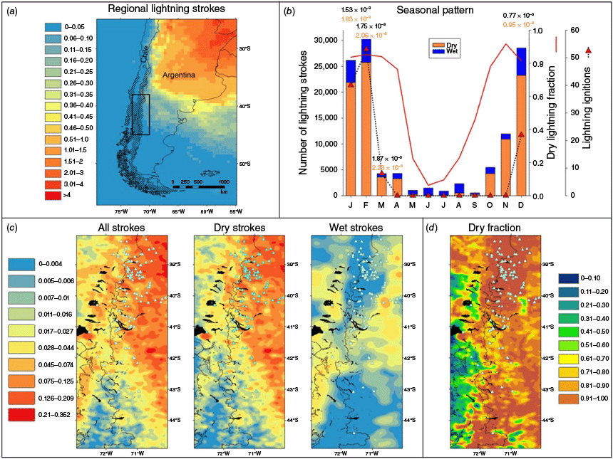
(a) Study area location (rectangle) and regional annual lightning density (strokes km−2 year−1) over southern South America (2010–20) derived from World Wide Lightning Location Network (WWLLN; Kaplan and Lau 2022). Hatched areas correspond to the distribution of southern temperate forests and shrublands (Olson et al. 2001). (b) Annual pattern of dry (orange) and wet (blue) lightning, dry fraction (red line) and lightning ignition occurrence (red triangles). Numbers in black are overall monthly lightning ignition efficiencies and in orange are dry lightning ignition efficiencies. (c) Spatial patterns of total, dry and wet lightning density (strokes km−2 year−1) and location of lightning ignitions (light blue triangles, 2014–24). (d) Spatial distribution of the dry lightning fraction and location of lightning ignitions (light blue triangles, 2014–24).
LIW have, until the 1980s, been considered rare in northern Patagonia. Within the Argentinean national parks of northern Patagonia (covering ~906,000 ha), for the period 1950–80, LIW represented 5% of all fires, encompassing 18.4% of the area burned (Bruno and Martin unbubl. data). In south-central Chile the perception of lightning being unimportant was similar. Until the 2000s all fires were assumed to be anthropogenic (González 2005). Large LIW started in the late 1990s, and early 2000s triggered a change in the perception of the incidence of lightning fire in both regions. Early analyses indicated a step-like 2.5-fold increase in the incidence of LIW after the 1980s (Veblen et al. 2008). In 2015 and 2021, severe lightning storms ignited multiple fires including the single largest forest fire recorded in the region (2015 Cholila fire), and the largest fire recorded in north Patagonian national parks (2022 Steffen-Martin fire). These early warnings have raised serious concerns among fire managers regarding necessary changes in detection and suppression strategies. Nevertheless, despite these preliminary evidences of a potential qualitative change in fire regime, there is still no good understanding of the conditions that promote lightning and lightning-ignitions in northern Patagonia, nor a formal analysis of spatial patterns and trends of this growingly important source of wildfire for this part of the world.
We here analyze spatial lightning stroke data from northwestern Patagonia (Fig. 1a) over the last decade in combination with a historical record of LIW and gridded atmospheric reanalysis data to: (1) identify the main temporal and spatial patterns of lightning, dry lightning and lightning ignition efficiency (LIE), (2) relate lightning occurrence with main large-scale atmospheric patterns and identify key synoptic indices of lightning occurrence, (3) capture key meteorological/fire weather conditions that control ignition by lightning, and (4) analyze multidecadal trends in the identified synoptic and meteorological drivers of lightning and lightning ignitions.
Material and methods
We used stroke data from the World-Wide Lightning Location Network (WWLLN). WWLLN is a ground-based lightning detection network that used the time of group arrival of very low-frequency lightning sferic to detect and to localize lightning strokes (Dowden et al. 2002). Several studies (Bovalo et al. 2012; Virts et al. 2013, 2015; Soula et al. 2016; Holzworth et al. 2019; Lin and Chou 2020; among others) have shown the ability of the network to capture the main features of global and regional lightning activity despite its low stroke detection efficiency. Since its first set of global observations in August 2004, the WWLLN has grown steadily in the following years and has improved its stroke detection efficacy until 2014, when WWLLNs stroke detection efficiency stabilized (Kaplan and Lau 2022). Thus we analyzed the period 1 May 2014–30 April 2024 (10 fire seasons). The study area encompassing ~195,000 km2 includes a west-east trans-Andean rainfall gradient (~3000–500 mm year−1) of which roughly two-thirds is covered by Valdivian rainforests and temperate forests/shrublands, and one-third by steppe grasslands (Fig. 1a; Olson et al. 2001). We temporally and spatially matched the 117,210 strokes recorded with daily precipitation data from the National Oceanic and Atmospheric Administration (NOAA) Climate Prediction Center (CPC) Global Unified Gauge-Based Analysis of Daily Precipitation (https://psl.noaa.gov/data/gridded/data.cpc.globalprecip.html). Previous studies have classified thunderstorms as wet if they were reported on days with a total rainfall >2.54 mm (Rorig and Ferguson 1999). As our daily precipitation data were reported to nearest mm, we classified strokes as dry/wet when they fell within/outside daily interpolated fields of precipitation of <3 mm. Monthly dry fraction (dry strokes/total strokes) was calculated seasonally and spatially. We identify individual storm events by temporally joining strokes that occurred at time intervals <60 min (hereafter 1-h clusters). Storm duration was calculated as time lapse between first and last stroke within 1-h clusters. Storm size was estimated by convex hull envelopes that enclosed of strokes of 1-h clusters within the study area. Dry/wet storms were defined as storms with >90% dry/wet strokes and mixed storms as having 10–90% dry strokes.
Lightning ignitions (Supplementary Table S1) were compiled over the same period from records of the National Park Service and the Secretary of Environment and Sustainable Development, Argentina (https://www.argentina.gob.ar/interior/ambiente). Fires not reported by these agencies were completed by extensively searching for Argentinean and Chilean press releases of digital news using the keywords ‘incendio’ and ‘rayo’, ‘incendio’ and ‘tormenta eléctrica’ (Supplementary Table S1). Date of ignition was equaled to the date of the reported first smoke column, except in cases in which no strokes were detected during the day of ignition. In these cases, the date of the first 1-h cluster preceding the reported ignition were used as corrected date of ignition. Holdover time lags of these correction ranged from 1 to 3 days but in exceptional cases were as long as 15 days. LIE was calculated as the number of ignitions recorded/number of detected strokes (Podur et al. 2003). Spatial patterns of LIE were estimated by dividing the spatially interpolated number of ignitions and spatially interpolated strokes density.
Storm clusters were matched to the date of lightning ignitions (Supplementary Table S1). Most candidate storm clusters lasted several hours and were large enough to unequivocally explain the ignition/s. In a few cases we matched the ignition to the immediately preceding storm cluster that occurred over the ignition point leading to 1–2-day (but up to 15-days) holdover times. Storm-level ignition efficiency was calculated as the number of ignitions/number of strokes of the storm associated to the ignition/s. To compare relative ignition efficiency between different vegetation types affected by lightning, we selected storms that ignited at least one fire for which we also had information on the possible dominant vegetation ignited. We calculated the conditional (i.e. given that they actually ignited at least one fire/storm) ignition efficiency by different vegetation types and compared their distributions. For this we used the World Wildlife Fund (WWF) Valdivian Ecoregion vegetation/land cover map (Lara et al. 1999). For the three largest/longest storm clusters, we reconstructed the storm behavior by plotting in space convex hull polygons, hourly-averaged stroke centroid locations and dry vs wet stroke distributions, as well as the location of ignition/s.
To describe different large-scale patterns of atmospheric circulation associated to magnitude and location of different storm clusters, we first ranked the five largest/longest-lasting storms accounting for 19% of all recorded strokes (Supplementary Table S2). These five events were used to characterize conditions associated with extreme convective/lightning activity. An additional 14 storm clusters that accounted for another 17% of all recorded strokes were used to characterize remaining large storms that affected the trans Andean gradient. In addition, we classified smaller 1-h clusters by geographic location: eastern Patagonian low elevation plains (east of 71°W, south of 40°S), northeastern low elevation plains (east of 71°W, north of 40°S), northern portion Chile (41°S in Chile) and southern portion Chile (41°S in Chile).
Using the dates of groups of 1-h clusters, we generated daily composites of mean 300 hPa geopotential height anomalies, low-level (850 hPa) wind vectors and vector anomalies, and afternoon (18z) surface lifted best four-layer index (SLI). This was obtained from the National Centers for Environmental Prediction-National Center for Atmospheric Research (NCEP-NCAR) Reanalysis (https://psl.noaa.gov), a commonly utilized measure of air stability (SLI 0 to −3: marginally unstable air, −3 to −6: moderately unstable air).
Daily meteorological variables (mean air temperature, total precipitation and mean relative humidity) were obtained from European Centre for Medium-Range Weather Forecasts (ECMWF) AgERA5 daily database (Copernicus Climate Change Service (C3S) 2017) for an 11-day window (−5 to +5 days), centered around storm clusters that produced lightning ignitions, clusters that produced fires >200 h and clusters of >400 strokes that did not produce reported ignitions. Data was averaged over the convex hull polygon of each storm cluster. Daily Fire Weather Index (FWI) values were obtained from the Copernicus Emergency Management Service (CEMS) database (ECMWF ERA5 reanalysis).
Time series of summer atmospheric instability were generated by calculating the January–February mean daily % of the study area covered SLI <−3 (1950–2024). Trends in fire weather severity were obtained by calculating annual number of days with mean FWI >30 over the study area. Trends in annual lightning ignitions and decadal-scale percentages of area by lightning versus human causes were assessed from fire records (1954–2024) of National Park Service (Lanín, Nahuel Huapi, Lago Puelo and Los Alerces National Parks, Bruno and Martin, unpubl. data). To avoid years with no ignitions, a 3-year moving average filter was applied. All trends were assessed using Theil–Sen slope estimates (Helsel and Hirsch 1995) and significance levels of slopes using Mann–Kendall tests (Sen 1968).
Results
Spatial and temporal patterns of lightning occurrence, dry fraction, lightning ignitions and ignition efficiency
From May 2014 to April 2024 the WWLLN detected 117,210 lightning strokes within the study area (0.06 strokes km−2 year−1), out of which 57.3% were dry lightning strokes. Lightning stroke occurrence was concentrated during the summer months (February > December > January). The dry lightning stroke fraction remained above 0.75 between October and April, and below 0.25 during the cool/wet season (May–August; Fig. 1b). During this period, 123 LIW were recorded (ignition efficiency 1.05 × 10⁻³ for all lightning and 1.31 × 10⁻³ for dry lightning). LIE increased during the summer from 0.77 × 10⁻³ (December) to 1.87 × 10⁻³ (March), while from April to November no lightning ignitions occurred (Fig. 1b) and dry lightning ignition showed higher efficiency ranging from 0.95 × 10⁻³ (December) to 2.23 × 10⁻³ (March; Fig. 1b).
Lightning, particularly dry lightning, was concentrated in the northeastern quadrant of the study area (Fig. 1c) on the leeward slopes of the Andean cordillera (>0.1 strokes km−2 year−1). South of 41°, the area of high lightning density tended to shift east of the continental divide (Fig. 1c). South of 44°S lightning becomes a rare phenomenon (<0.02 strokes km−2 year−1). Wet strokes prevailed at low densities (<0.04 strokes km−2 year−1) west of the Andes south of 39°S and on the Patagonian plains north of 42°S (Fig. 1c). Dry fraction was maximal (>0.9) across a north-south stretching band located between 71 and 72°W along the Andes (Fig. 1d) coincident with the distribution of Andean Patagonian forests (Fig. 1a). On the western foothills of the Andes dry fraction decreased abruptly below 0.4 south of 39°S (Fig. 1d).
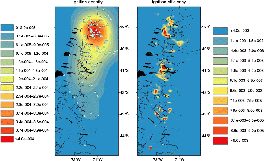
Lightning ignitions concentrated (>2.5 × 10⁻⁴ ignitions km−2 year−1) in the central northern portion of the study area (70.5–72°W, 38.5°–40°S; Fig. 2). Lightning ignition declined abruptly towards the western slopes of the Andes south of 40°S, and rather gradually southwards on the lee side of the Andes, while south of 43°S lightning ignition were very rare (Fig. 2). Areas of highest dry LIE (>6.0 × 10⁻³) were concentrated along a north-south stretching strip along the Andes from ~38.5° to 43°S, mostly on areas covered by forests (Fig. 2).
Patterns of lightning storm occurrence
During 2014–24, a total of 1450 1-h clusters were detected by the WWLLN within the study region, and of these 28.6% had at least 10 strokes (41.5 storms year−1). Of these, 54.2% were dry, 30.8% were wet and 15.0% were mixed lightning storms. Summer (December–February) storms (>10 strokes) represented 39.7% of all storms and strokes from these storms represented 70.2% of all recorded strokes. Mean annual summer storms rate (≥10 strokes) was 16.5 storms year−1, with a maximum during 2021–22 of 26, and a minimum of 10 storms during 2022–23 (Supplementary Fig. S1). Larger storms (≥500 strokes) occurred at a rate of 3.7 storms year−1, with a maximum of eight events during 2021–22 and no events during 2018–19 (Supplementary Fig. S1). Seasonally, lightning storms recurred from a maximum during February of 5.1 storms to a minimum of 0.2 storms in June and July. Wet lightning storms had a maximum in the winter (July; 2.4 storms) and minimum of 0.4 storms in summer months (Supplementary Fig. S2).
Spatially, summer storms (≥10 strokes) concentrated in the northeastern corner (>2.0 storms month−1; Supplementary Fig. S3), while intermediate summer storm rates (1–1.5 storms month−1) developed in the remaining area north of 42.5°S and east of 72°W. During winter a region of increased lightning storm (≥10 stokes) activity appeared west of 72°W and south of 42°S (<1 storm month−1; Supplementary Fig. S3). The largest storms occurred during summer and the smallest storms occurred during May–September (Supplementary Fig. S4). Summer storms (≥10 strokes) doubled in duration during winter (Supplementary Fig. S5). Median stroke rates of summer storms more than doubled those of winter storms (Supplementary Fig. S6). The top five largest–longest lightning storms recorded in the area (2014–24) had an average duration of 18.8 h and size of 97,798 km2, covering 50.2% of the study area (Supplementary Table S2). These five events produced 24,061 strokes (20.5% of all recorded fires).
Storm-level ignition patterns and efficiency
Thirty-six (18%) of the 200 summer storms (≥10 strokes) ignited 124 fires that burned 55,709 ha (Supplementary Fig. S7). More than two-thirds of the burned area consumed native forests (77 ignitions) while the remaining third burned grasslands (22.6%) and pine plantations (7.8%; Fig. 3a, b).
(a) Area burned by lightning ignitions (2014–24) by vegetation type (represented by >50% of area burned). (b) Location of lightning ignitions by vegetation type (Lara et al. 1999) affected (2014–24). (c) Ignition efficiency of storms that generated ignitions (amount of ignitions/number of strokes from storms that produced ignitions) by vegetation type affected >50%.
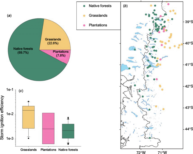
Mean ignition efficiency of summer storms was 3.10 × 10⁻³, whereas the efficiency of storms that produced at least one ignition (conditional efficiency) was 1.72 × 10⁻². When partitioned by vegetation type ignited, grasslands had the highest conditional efficiency (1.46 × 10⁻²) while efficiency of forests and plantations was an order of magnitude lower (Fig. 3c).
The three largest–longest recorded storms (Supplementary Fig. S8), despite having a relatively low ignition efficiency (1.04 × 10⁻³) produced large numbers of lightning (6817 strokes storm−1) that ensured the ignition of 18 fires, three of which became the largest lightning forest fires recorded during that period (39,501 ha burned, 96.6% of the total forest area burned; Supplementary Table S2, Supplementary Fig. S8, see Supplementary material for a detailed description of storm behavior).
Large-scale atmospheric patterns of lightning storm occurrence
The five largest–longest lightning storms (accounting for 19% of recorded lightning strokes) were associated to anomalous high pressure located over the southern Atlantic Ocean and Southern Ocean, centered southwesterly of the southern tip of South America with elongated upper-level ridge reaching southern Brazil and Uruguay. In addition, northwest and southwest of the ridge two deep troughs develop (Fig. 4a). This pattern generates a strong low-level northerly-northeasterly flow of subtropical air that can reach ~43°S on either side of the Andes. Afternoon SLI reached average values of <−3 over most of the study area, suggesting moderately unstable air with enhanced convective potential (Fig. 4c, e).
300 hPa geopotential height anomalies (m; 1991–2020 climatology) during days when the top five largest–longest lightning storms occurred within the study area (Supplementary Table S2). (a) During 14 additional large trans-Andean lightning storms that affected both western and eastern slopes of the Andean cordillera; (b) stippled lines are boundaries of areas with significant anomalies (P < 0.1). Geographic distribution of lightning strokes of events are shown as red dots in inset maps. For the same storm event days (c, d, respectively), low-level (850 hPa) wind vectors (m s−1, for scale the longest arrow corresponds to ~15 m s−1) and low-level (850 hPa) wind vector anomalies (m s−1; 1991–2020 climatology); (e, f) and afternoon (18z) surface lifted best four-layer index (light blue-violet colors).
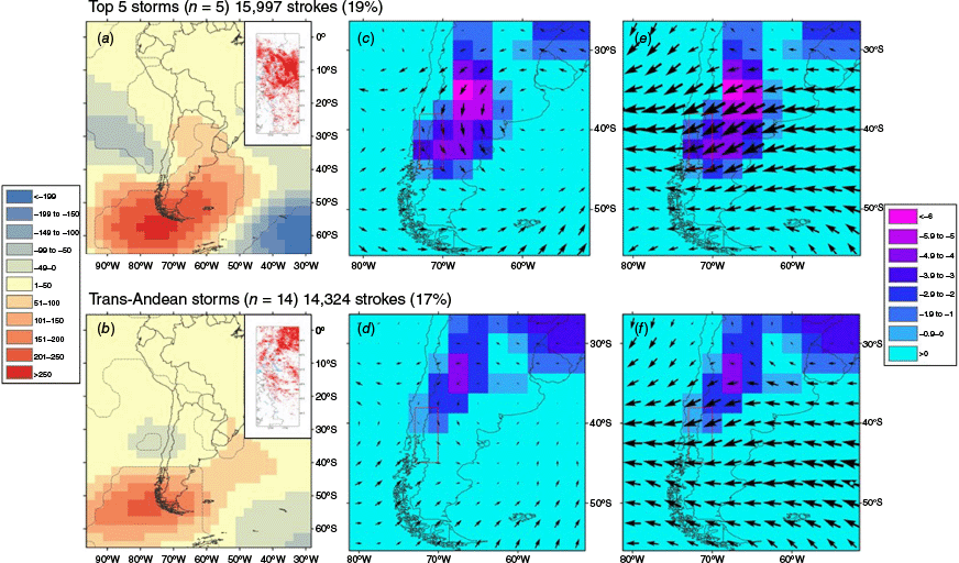
A similar yet less developed pattern is evident when analyzing daily conditions during the 14 remaining large scale lightning storms (storms of >50,000 km2 that affected both slopes of the Andes). The high-pressure anomaly tends to be more restricted to the Southern Ocean location and the troughs are weaker (Fig. 4b). A weaker meridional low-level flow is evident however, wind anomalies are easterly rather than northeasterly, thus suggesting that the source of warm moist air is originated on more temperate conditions of the mid-latitude Atlantic Ocean (Fig. 4d, f). Mean SLI are generally less negative and areas of SLI <−3 are restricted to the northeast corner of the study area, thus suggesting less intense potential convection (Fig. 4d, f).
When 300 hPa geopotential height anomalies during large lightning storms in our study region are displayed across the Southern Hemisphere (Supplementary Fig. S9), a Rossby Wave-4 pattern becomes evident in which four mid-high latitude highs are opposed, forming a cross with axes South America-Australia and South Africa/Madagascar-Southern Pacific region. Interspersed between highs are four deep lows forming a similar 45°-rotated low pressure cross-like pattern (Supplementary Fig. S9). The rotation of this pattern generates wave trains traveling east so that, as long as the pattern persists, periodically a high-pressure anomaly can appear positioned to potentially produce the conditions that promote extensive lightning in the study region (Supplementary Fig. S10). Other patterns related to more localized lightning storms can be identified (Supplementary Figs S11, S12, see Supplementary material).
Meteorological/fire weather controls of lightning ignition
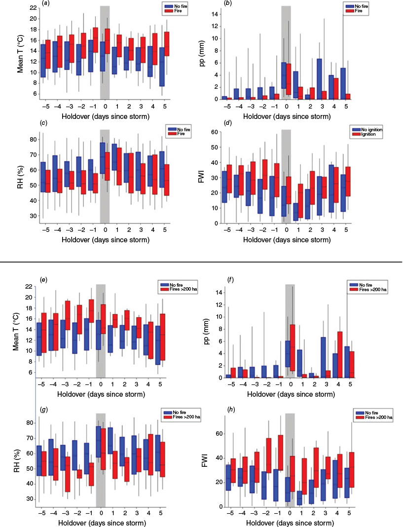
Meteorological conditions changed abruptly during the passage of lightning storms. In general, post storm days +1 and +2 were wetter, cooler, and had higher humidity than pre-storm conditions (Fig. 5). Lightning storms that generated ignitions, particularly lightning storms that generated fires >200 ha, were associated with much warmer and dryer air conditions during a window extending from −3 to +2 day around the storm event, than large lightning storms (>400 strokes) that did not produce ignitions (Fig. 5a, c, e, g). Rainfall tended to be slightly reduced the 3–4 days preceding storm that produced ignition compared to those that did not, but precipitation during the storms were similar (Fig. 5b, f). FWI was the condition that differed the most between igniting (particularly large fire-igniting) and non-ignition storms (Fig. 5d, h). One–two days before storms, median FWI was >30 for ignition-producing events, approximately doubling those of non-ignition events (Fig. 5d). Statistical differences are even more marked when considering storms that started >200 ha fires. More than 75% of these storms had 1–2 days before the event FWI >30, compared to 75% of the non-igniting large storms (FWI <30, Fig. 5h). Therefore, FWI = 30 can be considered a reasonable threshold beyond which LIE increases considerably.
Boxplots of storm-level spatially averaged daily mean temperature (T; °C; a, e), precipitation (pp; mm; b, f), air relative humidity (RH; %; c, g) and fire weather index (FWI; d, h) calculated for an 11-day moving window centered during days of occurrence of lightning storms (>400 strokes) that did not ignite fires (blue bars), lightning storms associated with recorded lightning ignitions (red bars, top panel) and LIW that burned >200 ha (red bars, bottom panel).
Temporal trends in drivers of lightning, lightning efficiency and lightning ignitions
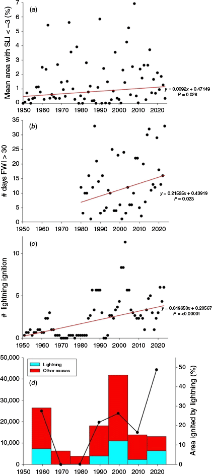
During the relatively short period of our record, none of the indicators of summer lightning activity (>10, >500 strokes, total number of summer strokes) showed significant temporal trends (Mann Kendall Zs: 0.72, 0.09, −0.36, respectively, P > 0.1; Supplementary Fig. S1). Thus, to explore possible longer-term trends we used SLI, a proxy for lightning activity. The mean daily (January–February) % area with SLIs <−3, increased ~2.4-fold over the last 74 years (P = 0.03, slope 0.01 year−1; Fig. 6a). Similarly, for a shorter period of analysis (1979–2024) the mean number of days per year with FWI >30 increased 2.64-fold in 45 years (from ~6.2 to ~16.4 days; P < 0.02, slope 0.22 year−1; Fig. 6b). Concurrently, the number of lightning ignitions reported in four major national parks within the study area increased ~18-fold (from ~0.2 to ~3.9 ignitions year−1; P < 0.00001, slope ~0.05 ignitions year−1; Fig. 6c). The area burned by LIW peaked during the decade centered in year 2000 (>40,000 ha) and a second peak during the decade centered in 1960, however only during the last decade the area burned by lightning reached 50% of the total area burned (Fig. 6d).
Annual time series (1950–2024) of (a) mean % daily area (January–February) with Surface Lifted Index (SLI) <−3 (indicating moderate or atmospheric instability); (b) number of days with Fire Weather Index (FWI) >30 (indicating increased Lightning Ignition Efficiency (LIE) (1979–2024)); (c) number of lightning ignitions (3-year moving average) reported in Nahuel Huapi, Lanín, Los Alerces and Lago Puelo National Parks (1954–2024, 906,000 ha) and (d), decadal values lightning (light blue bars) vs human (red bars) area burned and percent area burned by lightning for fires occurred in Nahuel Huapi, Lanín, Los Alerces and Lago Puelo National Parks (1954–2024, 906,000 ha) (black line). Red lines and linear equations in a–c are based on Theil–Sen estimates of temporal trend and significance values reported are based on Mann–Kendall tests.
Discussion
Unprecedented increases in lightning ignitions frequency area burned by LIW detected during the last 2–3 decades in northwestern Patagonia are possibly due to a combination of (1) trends of more frequent occurrence of large-scale atmospheric patterns that are conducive of large, severe lightning storms that anomalously reach mid-high latitudes of southern South America, and (2) warming-drying trends that impact on fuel conditions, increasing the likelihood of lightning to ignite vegetation.
Here we show that the largest and most severe events of increased lightning activity and ignitions over northwestern Patagonia are related to an amplified upper-level ridge centered at the southern tip of the continent, expanded as far north as ~30°S across over the Atlantic coast of southern South America, and bordered by two deep troughs northwest and southwest of the ridge. This pattern resembles the pattern that leads to a southerly type of the SALLJ (Marengo et al. 2004; Salio et al. 2007) identified as the Low-Level Jet (LLJ)-Argentina (EuMeTrain 2012). During these events a strong (~10–12 m s−1) northerly/northeasterly low-level (1–2 km) air flow establishes that, funneled by the Andes, transports large amounts of heat and moisture from mid-latitudes of the Atlantic Ocean enhancing convection in the study region. During these events lasting one to a few days during full austral summer (January–February), afternoon SLI values <−3 develop over the region, suggesting moderate levels of upper air instability that can lead to large severe thunderstorms (thousands of lightning strokes) with chances of igniting wildfires. This pattern contrasts largely with the synoptic pattern associated to fall-winter strokes over the western coast of Chile at ~40°–55°S, consisting of a cold front reaching the west coast of South America at ~40°S (Supplementary Fig. S13; Garreaud et al. 2014).
We propose that intense summer lightning storm activity over northern Patagonia is remotely forced by extratropical Rossby wave trains, propagating from the Pacific Ocean that modulate the strength of the SALLJ (Jones et al. 2023). We show that the largest–longest lightning events igniting extensive wildfires in northern Patagonia were associated to a high amplitude Rossby Wave-4 pattern established over the Southern Hemisphere. Austral summers when the intensity of this pattern was amplified (2021–2, Supplementary Fig. S1) had abundant lightning and lightning ignitions, coincided with east-traveling wave trains that periodically develop a high-pressure anomaly off the coast of southern South America (Supplementary Figs S9, S10). In contrast, summers of low lightning activity in northwestern Patagonia (2016–17, Supplementary Fig. S1) coincide with a less meandering Rossby wave pattern producing stronger zonal stable airflow (Supplementary Fig. S10). Trend analyses show that during the last seven decades, the number of days with convective activity in northern Patagonia are becoming more frequent. A sharp increase in atmospheric summer instability is evident in the early 2000s, after which very few years showed summers with low instability.
Meandering, high amplitude Rossby waves with zonal numbers 3–8, have been linked to a variety of extreme meteorological events at mid-latitudes such as heatwaves, cold spells, as well as floods in of both the northern (Screen and Simmonds 2014; Yang et al. 2024) and Southern Hemisphere (Ali et al. 2022). Furthermore, trends of increasing meandering of the circulation patterns have been detected during the last four decades for both the Northern Hemispheres (Di Capua and Coumou 2016; Fragkoulidis 2022). Specifically, trends of increasing wave amplitude during the austral summer and fall over the southern tip of South America are evident. In addition, wave phase trends show a pervasive pattern in which ridges tend to become more prevalent west of the continent (South Pacific/Bellingshausen Sea) and troughs east of the continent over the south Atlantic/Amundsen Sea (Fragkoulidis 2022), thus resembling the Rossby wave-4 atmospheric circulation pattern associated here to enhanced convection, lightning storms and lightning ignitions (Fig. 4a, Supplementary Fig. S9). These trends are consistent with observed century-long increases in warm season precipitation over southeastern South America concurrent with an intensified SALLJ, attributed to decadal variability in the Atlantic temperature patterns (negative Atlantic Multidecadal Oscillation (AMO), Jones and Carvalho 2018), enhanced south Atlantic Ocean warming (Varuolo-Clarke et al. 2022), stratospheric ozone depletion, a poleward drift of the mid-latitude jet and the southward expansion of the summertime Hadley cell (Gonzalez et al. 2014).
Seasonally, lightning ignitions in this region approximately correlated with stroke occurrence rates except during late spring (October–November) when despite relatively high stroke frequency, no ignitions occurred, possibly because fuels are still too wet to ignite. Overall, LIE 1.05 × 10⁻³ (or 0.105%) for northern Patagonia lies in the lower values of the range found for a variety of biomes (0.1–3%; Pineda et al. 2024). Ignition efficiency peaked in late summer when, despite reductions in lightning occurrence, both live and dead fuels are driest (Barberá et al. 2023). Spatially, ignition efficiency is maximal in eastern Andean forests and decreases in eastern grasslands and western rainforests. This pattern is consistent with the spatial pattern of the dry lightning fraction which was maximal over the Andes and decreases west and east of it (Fig. 1d). Higher ignition efficiency in dense forests suggests that fuel loads and fuel bulk density are playing an important role on ignition (Hessilt et al. 2022). Also, ignitions are frequently coincident with the edges, head or tail of major thunderstorm paths where the highest incidence of dry lightning tend to occur (Supplementary Fig. S8).
Vegetation controlling fuel structure played an important role in determining lightning ignition risk. When we analyzed storms that produced ignitions, grasslands and shrublands dominated by fine fuels were an order of magnitude more prone to ignite by lightning than native forests or pine plantations. Increased ignition risk in fine-fuel dominated plant communities have also been detected in shrublands and grasslands elsewhere (Vecín-Arias et al. 2016; Nampak et al. 2021; Rao et al. 2023). Plant communities dominated by fine-fuels need less lightning strike attempts to produce an ignition, but are more readily put out by less amounts of precipitation if storms discharge, even small amounts of water. In contrast, forests may need a higher number of attempts to ignite coarser fuels but, once ignited, smoldering behavior may better to endure rain associated with the storm, more effectively producing fire. In fact, several lightning ignited forest fires in this study were reported several days, and up to 2 weeks after the igniting storm when meteorological conditions were more conducive of fire (e.g. the Cholila fire ignited on 3 February detected on 16 February 2015).
A dominant driver LIE was antecedent weather impacting on live and dead fuel condition (Lutz et al. 2009; Abatzoglou et al. 2016; Hessilt et al. 2022; Rao et al. 2023). Lightning tended to produce ignitions when preceded by hotter, drier air conditions during a window of 2–3 days before and 2–3 days after the storm, relative to conditions during large storms that did not produce recorded ignitions. The single most important variable that controlled ignition efficiency was FWI 2 days before the storm occurred, and to a less degree during and 2 days after the storm, suggesting that ignition probabilities are controlled by longer-term fire weather. Besides short-term conditions affecting fine fuels reflected in our analyses by temperature and relative humidity (RH), FWI is influenced by other components of the such, as the duff moisture and indication of fuel consumption in moderate duff layers and medium-size woody material, and the drought code a numeric rating of moisture effects of seasonal drought on coarser forest fuels, and an indicator of the amount of smoldering in deep duff layers and large logs. Our analyses identified a threshold FWI value of 30, 1–2 days before lightning storms above which probabilities of igniting fires (particularly fires >200 ha) increase sharply, compared to pre-storm conditions in which FWI remains below 30.
In concordance with many other regions globally (Jones et al. 2022) extreme fire weather conditions in northwestern Patagonia are becoming more common in recent decades. The number of days in which the FWI >30 has increased is 164% during the last 45 years (from 6.2 to 16.4 days of extreme weather per season). This rate of increase is similar in magnitude to the largest increases in the number of days surpassing the 95th percentile of FWI (FWI95thd) found for southern Amazonia and the Pacific US (Jones et al. 2022), thus suggesting that this is not a regional phenomenon, but a manifestation of global climate change through drivers such as temperature or atmospheric vapor pressure deficit that strongly impact on fire weather (Jain et al. 2022). Aridification trends are also producing increased drought/heat induced mortality in moist forests (Suarez et al. 2004; Allen et al. 2010) potentially facilitating lightning ignitions to emerge as wildfires.
Clearly, the most compelling decadal trend detected was that of lightning ignitions recorded over four national parks within the study area. Here a 1700% increase in reported lightning ignitions from 1954 to 2024 suggests that both increases in atmospheric instability (particularly after the 1990s) and a rapidly increasing frequency of extreme fire weather days have interacted to sharply increase ignitions related to lightning storms. However, it is likely that fire weather played a predominant role particularly to produce larger fires. In fact, the area burned by LIW during the last decade has for the first time in the record matched that of human-ignited fires, thus suggesting that large LIW driven by extreme weather are growingly playing a preeminent and novel role in shaping fire regimes of northwestern Patagonia.
Several global climate models project for the end of the 21st century, increases in summer-fall low-level northerly moisture flux between 15 and 35°S associated with a strengthened SALLJ (Gomes et al. 2022). This suggests that conditions for large lightning storms potentially conducive of wildfire ignitions will steadily become more frequent. In addition, several climate models consistently show that for this and other regions (the Mediterranean and the Amazon Basin) that the emergence due to anthropogenic climate change of the FWI95thd is already underway, as the amount of warming in global mean temperature necessary to produce the emergence is only 1–1.5°C). Moreover, these models predict for southwestern South America an increase of FWI95thd of >20 days for the mid-21st century (Abatzoglou et al. 2019), thus suggesting a continued increase in the frequency of severe fire weather days. In a regional model trained with modern fire occurrence data, Kitzberger et al. (2022) report projected 2–3-fold and 3–8-fold increases in wildfire probabilities for the mid- and late 21st century, respectively, impacting on the most fire-sensitive forest types. Given that these are probabilities based on ignitions during the training period, future fire hazard could be underestimated by not considering forecasted increases in lightning ignition occurrence.
Multidecadal trends in two key proxies of lightning occurrence and critical fire weather for ignition suggests that the region is facing an ongoing qualitative change in fire regime, where large fires are becoming increasingly of lightning origin. These changes require urgent adaptation and mitigation actions. Managers are increasingly faced with significant challenges posed by LIW, a relatively novel (for the region) and complex type of event. Because natural ignitions often occur in remote and inaccessible Andean Forest areas, their detectability is lower due to lack of observers and cameras. The holdover fires caused by the smoldering effect further complicates the detection of ignitions which are normally performed by helicopter flight on the day after the storm. Thus, detection of smoke columns should be repeated several days after storms in order to detect lightning ignitions early that remained smoldering. Moreover, lightning storms can, unlike human-causes, produce simultaneous ignitions across the landscape. Thus, the logistics of dispatching and suppression of multiple ignitions in remote, often topographically complex areas, can become extremely difficult, thus increasing the chances that wildfire can spread, gain in size and intensity and quickly become less prone to be suppressed. Managers will need to develop new suppression protocols, different from human-ignited fires to deal with these difficulties. Under certain circumstances (e.g. non-extreme fire weather, risk to firefighters, high probability of self-containment) fire managers should consider a ‘let burn’ policy (Pietruszka et al. 2023). However, if fires are projected to become large due to meteorology, fuel conditions and continuity, etc. it is of prime importance to develop early attack strategies for which early detection is becomes key. Real time information based on lightning detection networks in concert with fire weather and fuel moisture parameters, will be key for a rapid response under these new conditions. Finally, LIW are affecting the most pristine old growth rainforest forests. These biomass-rich and diverse ecosystems are relatively vulnerable to becoming at risk of this novel fire events generated by lightning. Conservation agencies such as the National Park Service will need to develop restoration protocols adapted to restore species and functions over large, often inaccessible areas, where these events will increasingly occur.
Data availability
Archival lightning stroke data used in this study are copyrighted by the University of Washington and available at a nominal cost at https://wwlln.net/. Derived data can be requested from the corresponding author. Lightning ignition data used in this study are listed in Supplementary Materials.
Declaration of funding
This study was supported by Ministerio de Ciencia, Tecnología e Innovación Productiva (Argentina). Agencia Nacional de Promoción Científica y Tecnológica. Grant PICT-2017-2142 and Consejo Nacional de Investigaciones Científicas y Técnicas (Argentina) Grant PIP11220200102242CO.
Acknowledgements
The authors wish to thank the World-Wide Lightning Location Network (http://wwlln.net), a collaboration among over 50 universities and institutions, for providing the lightning location data used in this paper. We also thank Pablo Kitzberger for valuable computing assistance.
References
Abatzoglou JT, Kolden CA, Balch JK, Bradley BA (2016) Controls on interannual variability in lightning-caused fire activity in the western US. Environmental Research Letters 11, 045005.
| Crossref | Google Scholar |
Abatzoglou JT, Williams AP, Barbero R (2019) Global emergence of Anthropogenic climate change in fire weather indices. Geophysical Research Letters 46(1), 326-336.
| Crossref | Google Scholar |
Allen CD, Macalady AK, Chenchouni H, Bachelet D, McDowell N, Vennetier M, Kitzberger T, et al. (2010) A global overview of drought and heat-induced tree mortality reveals emerging climate change risks for forests. Forest Ecology and Management 259, 660-684.
| Crossref | Google Scholar |
Ali SM, Röthlisberger M, Parker T, Kornhuber K, Martius O (2022) Recurrent Rossby waves and south-eastern Australian heatwaves. Weather Climate Dynamics 3, 1139-1156.
| Crossref | Google Scholar |
Barros VR, Boninsegna JA, Camilloni IA, Chidiak M, Magrín GO, Rusticucci M (2015) Climate change in Argentina: trends, projections, impacts and adaptation. WIREs Climate Change 6, 151-169.
| Crossref | Google Scholar |
Barberá I, Paritsis J, Ammassari L, Morales JM, Kitzberger T (2023) Microclimate and species composition shape the contribution of fuel moisture to positive fire-vegetation feedbacks. Agricultural and Forest Meteorology 330, 109289.
| Crossref | Google Scholar |
Bovalo C, Barthe C, Bègue N (2012) A lightning climatology of the South-West Indian Ocean. Natural Hazards and Earth System Sciences 12, 2659-2670.
| Crossref | Google Scholar |
Bürgesser RE (2017) Assessment of the World Wide Lightning Location Network (WWLLN) detection efficiency by comparison to the Lightning Imaging Sensor (LIS). Quarterly Journal of the Royal Meteorological Society 143, 2809-2817.
| Crossref | Google Scholar |
Copernicus Climate Change Service (C3S) (2017) ‘ERA5 Ag: Agrometeorological indicators from 1979 to present derived from reanalysis.’ (Copernicus Climate Change Service Climate Data Store (CDS)) Available at https://cds.climate.copernicus.eu/cdsapp#!/dataset/sis-agrometeorological-indicators?tab=overview
Cunningham CX, Williamson GJ, Nolan RH, Teckentrup L, Boer MM, Bowman DMJS (2024) Pyrogeography in flux: reorganization of Australian fire regimes in a hotter world. Global Change Biology 30, e17130.
| Crossref | Google Scholar | PubMed |
Di Capua G, Coumou D (2016) Changes in meandering of the Northern Hemisphere circulation. Environmental Research Letters 11, 094028.
| Crossref | Google Scholar |
Dowden RL, Brundell JB, Rodger CJ (2002) VLF lightning location by time of group arrival (TOGA) at multiple sites. Journal of Atmospheric and Solar-Terrestrial Physics 64, 817-830.
| Crossref | Google Scholar |
EuMeTrain (2012) ‘The South American Low-Level Jet. Manual of Synoptic Satellite Meteorology.’ (Conceptual Models for Southern Hemisphere) Available at https://resources.eumetrain.org/satmanu/CM4SH/Argentina/Sallj/print.htm
Fragkoulidis G (2022) Decadal variability and trends in extratropical Rossby wave packet amplitude, phase, and phase speed. Weather Climate Dynamics 3, 1381-1398.
| Crossref | Google Scholar |
Garreaud RD, Nicora MG, Bürgesser RE, Ávila EE (2014) Lightning in Western Patagonia. Journal of Geophysical Research: Atmospheres 119, 4471-4485.
| Crossref | Google Scholar |
Gomes GD, Nunes AMB, Libonati R, Ambrizzi T (2022) Projections of subcontinental changes in seasonal precipitation over the two major river basins in South America under an extreme climate scenario. Climate Dynamics 58, 1147-1169.
| Crossref | Google Scholar |
González ME (2005) Fire history data as reference information in ecological restoration. Dendrochronologia 22, 149-154.
| Crossref | Google Scholar |
Gonzalez PLM, Polvani LM, Seager R, Correa GJP (2014) Stratospheric ozone depletion: a key driver of recent precipitation trends in South Eastern South America. Climate Dynamics 42, 1775-1792.
| Crossref | Google Scholar |
Hessilt TD, Abatzoglou JT, Chen Y, Randerson JT, Scholten RC, van der Werf G, Veraverbeke S (2022) Future increases in LIE and wildfire occurrence expected from drier fuels in boreal forest ecosystems of western North America. Environmental Research Letters 17, 054008.
| Crossref | Google Scholar |
Holzworth RH, McCarthy MP, Brundell JB, Jacobson AR, Rodger CJ (2019) Global distribution of superbolts. Journal of Geophysical Research: Atmospheres 124(17–18), 9996-10005.
| Crossref | Google Scholar |
Jain P, Castellanos-Acuna D, Coogan SCP, et al. (2022) Observed increases in extreme fire weather driven by atmospheric humidity and temperature. Nature Climate Change 12, 63-70.
| Crossref | Google Scholar |
Jones C, Carvalho LMV (2018) The influence of the Atlantic multidecadal oscillation on the eastern Andes low-level jet and precipitation in South America. npj Climate and Atmospheric Science 1, 40.
| Crossref | Google Scholar |
Jones C, Mu Y, Carvalho LMV, Ding Q (2023) The South America Low-Level Jet: form, variability and large-scale forcings. npj Climate and Atmospheric Science 6(1),.
| Crossref | Google Scholar |
Jones MW, Abatzoglou JT, Veraverbeke S, Andela N, Lasslop G, Forkel M, et al. (2022) Global and regional trends and drivers of fire under climate change. Reviews of Geophysics 60, e2020RG000726.
| Crossref | Google Scholar |
Kalashnikov DA, Abatzoglou JT, Nauslar NJ, Swain DL, Touma D, Singh D (2022) Meteorological and geographical factors associated with dry lightning in central and northern California. Environmental Research: Climate 1, 025001.
| Crossref | Google Scholar |
Kaplan JO, Lau KHK (2022) World wide lightning location network (WWLLN) global lightning climatology (WGLC) and time series, 2022 update. Earth System Science Data 14(12), 5665-5670.
| Crossref | Google Scholar |
Kitzberger T, Tiribelli F, Barberá I, Gowda JH, Morales JM, Zalazar L, Paritsis J (2022) Projections of fire probability and ecosystem vulnerability under 21st century climate across a trans-Andean productivity gradient in Patagonia. Science of The Total Environment 839, 156303.
| Crossref | Google Scholar | PubMed |
Lara A, Rutherford P, Montory C, Bran D, Pérez A, Clayton S, Ayesa J, Barrios D, Gross M, Iglesias G (1999) Vegetación de la eco-región de los bosques Valdivianos. Escala 1:500.000. Boletín Técnico FVSA 51, 1-24.
| Google Scholar |
Lin SJ, Chou KH (2020) The lightning distribution of tropical cyclones over the western North Pacific. Monthly Weather Review 148, 4415-4434.
| Crossref | Google Scholar |
Lutz JA, van Wagtendonk JW, Thode AE, Miller JD, Franklin JF (2009) Climate, lightning ignitions, and fire severity in Yosemite National Park, California, USA. International Journal of Wildland Fire 18, 765-774.
| Crossref | Google Scholar |
Marengo JA, Soares WR, Saulo C, Nicolini M (2004) Climatology of the low-level jet east of the Andes as derived from the NCEP-NCAR reanalyses: characteristics and temporal variability. Journal of Climate 17, 2261-2280.
| Crossref | Google Scholar |
Nampak H, Love P, Fox-Hughes P, Watson C, Aryal J, Harris RMB (2021) Characterizing spatial and temporal variability of lightning activity associated with wildfire over Tasmania, Australia. Fire 4(1), 10.
| Crossref | Google Scholar |
Olson DM, Dinerstein E, Wikramanayake ED, Burgess ND, Powell GVN, Underwood EC, D’Amico JA, Itoua I, Strand HE, Morrison JC, Loucks CJ, Allnutt TF, Ricketts TH, Kura Y, Lamoreux JF, Wettengel WW, Hedao P, Kassem KR (2001) Terrestrial ecoregions of the world: a new map of life on Earth. BioScience 51, 933-938.
| Crossref | Google Scholar |
Pérez-Invernón FJ, Gordillo-Vázquez FJ, Huntrieser H, Jöckel P (2023) Variation of lightning-ignited wildfire patterns under climate change. Nature Communications 14, 739.
| Crossref | Google Scholar | PubMed |
Pietruszka BM, Young JD, Short KC, et al. (2023) Consequential lightning-caused wildfires and the “let burn” narrative. Fire Ecology 19, 50.
| Crossref | Google Scholar |
Pineda N, Montanyà J, van der Velde OA (2014) Characteristics of lightning related to wildfire ignitions in Catalonia. Atmospheric Research 135–136, 380-387.
| Crossref | Google Scholar |
Pineda N, Rodríguez O, Casellas E, Bech J, Montanyà J (2024) Meteorological factors associated with dry thunderstorms and simultaneous lightning-ignited wildfires: The 15 June 2022 outbreak in Catalonia. Agricultural and Forest Meteorology 359, 110268.
| Crossref | Google Scholar |
Podur J, Martell DL, Csillag F (2003) Spatial patterns of lightning-caused forest fires in Ontario, 1976–1998. Ecological Modelling 164(1), 1-20.
| Crossref | Google Scholar |
Qie K, Wenshou T, Wang W, Wu X, Yuan T, Tian H, Luo J, Zhang R, Wang T (2020) Regional trends of lightning activity in the tropics and subtropics. Atmospheric Research 242, 104960.
| Crossref | Google Scholar |
Rao K, Williams AP, Diffenbaugh NS, Yebra M, Bryant C, Konings AG (2023) Dry live fuels increase the likelihood of lightning-caused fires. Geophysical Research Letters 50, e2022GL100975.
| Crossref | Google Scholar |
Rorig ML, Ferguson SA (1999) Characteristics of lightning and wildland fire ignition in the Pacific Northwest. Journal of Applied Meteorology 38, 1565-1575.
| Crossref | Google Scholar |
Salio P, Nicolini M, Zipser E (2007) Mesoscale convective systems over southeastern South America and their relationship with the South American Low-Level Jet. Monthly Weather Review 135, 1290-1309.
| Crossref | Google Scholar |
Screen JA, Simmonds I (2014) Amplified mid-latitude planetary waves favour particular regional weather extremes. Nature Climate Change 4, 704-709.
| Crossref | Google Scholar |
Sen PK (1968) Estimates of the regression coefficient based on Kendall’s tau. Journal of the American Statistical Association 63(324), 1379-1389.
| Crossref | Google Scholar |
Song Y, Xu C, Li X, Oppong F (2024) Lightning-induced wildfires: an overview. Fire 7, 79.
| Crossref | Google Scholar |
Suarez ML, Ghermandi L, Kitzberger T (2004) Factors predisposing episodic drought-induced tree mortality in Nothofagus: site, climatic sensitivity and growth trends. Journal of Ecology 92, 954-966.
| Google Scholar |
Soula S, Kasereka JK, Georgis JF, Barthe C (2016) Lightning climatology in the Congo Basin. Atmospheric Research 178, 304-319.
| Crossref | Google Scholar |
Varuolo-Clarke AM, Williams AP, Smerdon JE, Ting M, Bishop DA (2022) Influence of the South American low-level jet on the austral summer precipitation trend in southeastern South America. Geophysical Research Letters 49, e2021GL096409.
| Crossref | Google Scholar |
Veblen TT, Kitzberger T, Raffaele E, Mermoz M, González ME, Sibold JS, Holz A (2008) The historical range of variability of fires in the Andean-Patagonian Nothofagus forest region. International Journal of Wildland Fire 17, 724-741.
| Crossref | Google Scholar |
Vecín-Arias D, Castedo-Dorado F, Ordóñez C, Rodríguez-Pérez JR (2016) Biophysical and lightning characteristics drive lightning-induced fire occurrence in the central plateau of the Iberian Peninsula. Agricultural and Forest Meteorology 225, 36-47.
| Crossref | Google Scholar |
Virts KS, Wallace JM, Hutchins ML, Holzworth RH (2013) Diurnal lightning variability over the Maritime continent: impact of low-level winds, cloudiness, and the MJO. Journal of the Atmospheric Sciences 70, 3128-3146.
| Crossref | Google Scholar |
Virts KS, Wallace JM, Hutchins ML, Holzworth RH (2015) Diurnal and seasonal lightning variability over the Gulf Stream and the Gulf of Mexico. Journal of the Atmospheric Sciences 72, 2657-2665.
| Crossref | Google Scholar |
Yang X, Zeng G, Zhang S, Iyakaremye V, Shen C, Wang W‐C, Chen D (2024) Phase‐locked Rossby wave‐4 pattern dominates the 2022‐like concurrent heat extremes across the Northern Hemisphere. Geophysical Research Letters 51, e2023GL107106.
| Crossref | Google Scholar |