
Variability and trend of sea level in southern waters of Java, Indonesia
Amalia Nurlatifah A * , Martono A , Indah Susanti A and Mamat Suhermat A
A Center of Atmospheric Research and Technology, National Research and Innovation Agency, Bandung, West Java, 40173, Indonesia.
Journal of Southern Hemisphere Earth Systems Science 71(3) 272-283 https://doi.org/10.1071/ES21004
Submitted: 13 February 2021 Accepted: 3 October 2021 Published: 8 December 2021
© 2021 The Author(s) (or their employer(s)). Published by CSIRO Publishing on behalf of BoM. This is an open access article distributed under the Creative Commons Attribution-NonCommercial-NoDerivatives 4.0 International License (CC BY-NC-ND)
Abstract
The coastal area of Java has become a centre of new economic growth. The southern coast of Java, which is directly adjacent to the tropical Indian Ocean, is very vulnerable to sea level rise caused by climate change. Information on variability and trends in sea level are therefore very important for adaptation and disaster mitigation efforts. This research was conducted to determine the variability and trend of sea level in the southern sea of Java. Data used were from satellite altimeter from 1993 to 2018 and tide gauges from 2007 to 2015. The rate of sea level rise was analysed using linear regression. The results showed that the sea level variability in the southern waters of Java was influenced by the Asian–Australian monsoon, eddy currents and the Indian Ocean Dipole (IOD). During June–November, there was a very significant decrease in sea level, especially in the south of East Java and Central Java, which was caused by upwelling and eddy currents. When there was a positive phase of IOD and an El Niño event, sea level decreased; conversely, when the IOD was in a negative phase, sea level increased. For the period 1993–2018, the sea level in the southern waters of Java increased by about 4.7 mm/year.
Keywords: climate change, dipole mean index, EL Niño southern oscillation, Indonesia, Indian ocean dipole, sea level rise, sea level anomalies, southern Java, southern oscillation index, variability.
1 Introduction
Climate change due to global warming has caused various negative impacts around the world. One of the negative impacts of climate change is the rise in global sea level. From year to year, global sea level has increased. The average global sea level rise in the period 1880–1980 was about 1.8 ± 0.1 mm/year (Douglas 1991). The rate of global sea level rise during the 20th century was around 1.7 mm/year, which has risen to 3.2 mm/year in the last two decades (Meyssignac and Cazenave 2012; Church et al. 2013). From 1993 to 2011, the trend of global sea level increase was 2–4 mm/year (Fenoglio-Marc et al. 2012).
Indonesia, as the largest archipelago country in the world, is very vulnerable to the impact of sea level rise (Measey 2010; Zikra et al. 2015). Some of the potential impacts of sea level rise in coastal areas of Indonesia are increased coastal erosion, damage to coastal infrastructure and sea water intrusion (Nicholls 2003; Marfai 2014). Continuous sea level rise will disrupt economic activities and social systems in coastal areas (Li et al. 2009). It is projected that between 2030 and 2050 the coastal areas of Pakistan, Sri Lanka, south eastern Indonesia and east Africa (from Kenya to Mozambique) will experience land loss of between 2500 and 5000 km2/year (Oliver-Smith 2009).
The coastal area of Java has seasonal sea level variations with monsoon variability. Sea level in Indonesia is generally high during the northwest monsoon and low during the southeast monsoon (Triana and Wahyudi 2020). Triana and Wahyudi (2020) also suggested that sea level anomalies (SLAs) in Indonesia are possibly generated by extreme natural phenomenon events (such as La Niña and El Niño), while Fadlan et al. (2017) argued that sea level rise in the tropics is not only caused global warming but also by inter annual variability, such as the El Niño Southern Oscillation (ENSO) and the Indian Ocean Dipole (IOD). Further, some research states that sea level rise in southern Java continues to increase from year to year by several orders of magnitude, and that the causes of this are likely climate change; interannual phenomena, such as ENSO and IOD; as well as seasonal phenomena, such as monsoons (Fadlan et al. 2017; Wirasatriya et al. 2017; Triana and Wahyudi 2020).
Previous research on sea level around the coast of Australia found that a large part of its interannual and decadal variability is coherently and highly correlated with ENSO (White et al. 2014), while other research found that the regional sea level variability in the Pacific Ocean also correlated with ENSO (Zhang and Church 2011). These findings strengthen the hypothesis that sea level variability in southern Java is influenced by climate modes, one of which is ENSO.
The coastal area of Java has become a centre of new economic growth of which infrastructure development is often the first strategic part. Some infrastructure, such as the already operational southern Java highway and the international airport are only 5–60 and 330 m from the coast, respectively. Further, activities of the agricultural and aquaculture sectors are also growing rapidly along several areas of the southern coast of Java. Because the southern Java causeway, international airports, agricultural and aquaculture ponds are located close to the coastline, they are very vulnerable to sea level rise.
The southern coast of Java has moderate to high levels of vulnerability to rising sea level (Sofian 2010). One of the impacts of sea level rise in Indonesia is increased inundation in productive coastal zones (ADB 2016). Australia’s northwest coast, which are the closest waters to southern Java, has already experienced rising sea level. The average sea level rise around the Australian coastline for the period 1920–2000 was about 1.2 mm/year (Church et al. 2006), which became 1.6 mm/year for the period 1966–2009 (Siebentritt 2016). Fremantle, on the west coast of Australia, experienced an increase of 4 mm/year in the period 1992–2008 (Bicknell 2010).
The projected value of losses in the agricultural, aquaculture and settlement sectors due to the impact of sea level rise on the island of Java will reach around IDR 16 167 502 million or nearly 94% of the total losses throughout Indonesia (Hecht 2016). Therefore, information on variability and trends in sea level are very important for adaptation and disaster mitigation efforts in coastal areas. This study aims to determine the variability and trend of sea level in the southern sea of Java. The results of this study are expected to support development programs in the southern coastal region of Java so that the southern coast of Java can become a centre for new economic growth.
2 Data and methods
2.1 Research location
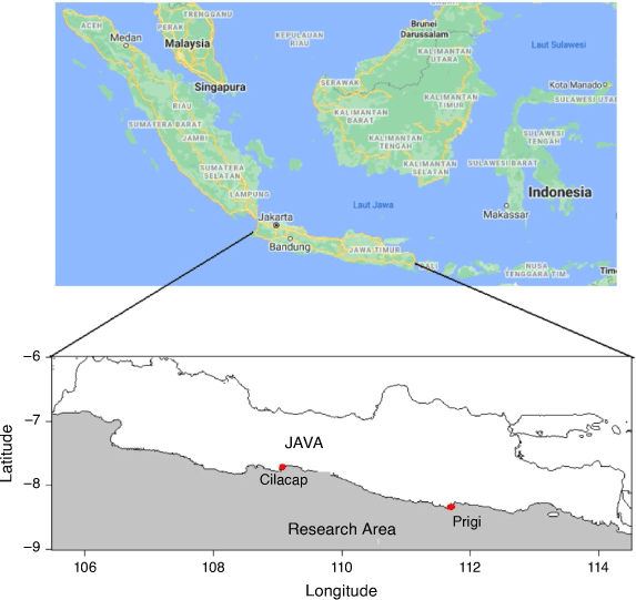
The focus of this research is the southern sea of Java 6–9°S and 105.5–114.5°E (Fig. 1). For the purposes of our research analysis, this area was divided into three parts: (1) south of West Java between 105.5°E and 108.5°E, (2) south of Central Java between 108.5°E and 111°E and (3) south of East Java between 111°E and 114.5°E. The data used consists of satellite altimeter data, tide gauge data and geostrophic current data from AVISO for 2000–2019. The satellite altimeter data used were absolute dynamic topography daily from 1993 to 2018 with spatial resolution of 0.25° × 0.25°, which was obtained from AVISO (https://las.aviso.altimetry.fr/las/UI.vm). The tide gauge data used were monthly sea level heights for 2007–2017 from the Cilacap tidal station in Central Java (with coordinates −7.75°S and 109.02°E) and the Prigi tidal station in East Java (with coordinates −8.28°S and 111.73°E). This in situ data was obtained from the Permanent Service for Mean Sea Level (https://www.psmsl.org/data/obtaining/stations). The IOD index or the Dipole Mode Index (DMI) was obtained from the National Oceanic and Atmospheric Administration (NOAA) (https://psl.noaa.gov/gcos_wgsp/Timeseries/Data/dmi.had.long.data). The ENSO index or Southern Oscillation Index (SOI) was also obtained from NOAA (https://www.cpc.ncep.noaa.gov/data/indices/soi). Positive values of SOI relate to La Niña events, and negative values of SOI relate to El Niño events.
|
Absolute dynamic topography daily data were processed into monthly data, and this monthly data were further processed into climatological data. From the climatological data, seasonal and annual averages were determined. Tide gauge data from Cilacap and Prigi were compared with the satellite altimeter data. The accuracy of the satellite altimeter data were analysed based on the correlation coefficients between satellite altimeter data and onsite data. In this study, analysis of seasonal variations, annual variations and trends in sea level in southern West Java, Central Java and East Java were conducted. The seasonal variation was divided into four: (1) the west season (the average of December–February (DJF)), (2) the first transitional season (the average of March–May (MAM)), (3) the eastern season (the average of June–August (JJA)) and (4) the second transitional season (the average of September–November (SON)). Then, the effects of the IOD and ENSO were analysed in each region. The trend of sea level rise in each area was analysed using linear regression.
3 Results and discussion
SLAs from the 2007–2016 satellite altimeter data and tide gauge data of the Cilacap and Prigi observation stations are shown in Fig. 2. In general, it shows that the satellite altimeter data has the same pattern as the in situ tide gauge data. The correlation coefficient between the satellite altimeter data and the tide gauge in the Cilacap and Prigi observation stations is very high, reaching 0.96.

|
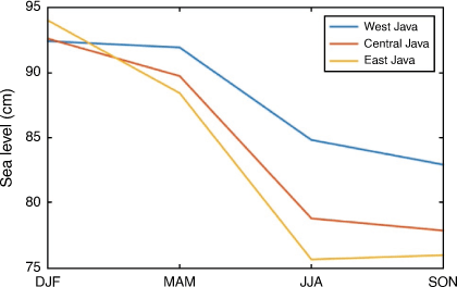
Oceanographic conditions in the southern sea of Java are influenced by the Asian–Australian monsoon (Wyrtki 1961). The Asian–Australian monsoon affects the seasonal variability of sea level in these waters. The spatial distribution of sea level height and the average seasonal surface wind circulation in the southern waters of Java are shown in Fig. 3. As can be seen from Fig. 3, during the Asian monsoon (DJF and MAM seasons), the sea level in southern Java tended to be higher when compared to the Australian monsoon (JJA and SON seasons). During the DJF season (Asian monsoon), sea level reached a maximum of about 0.93 m. The sea level in the southern waters of West Java and Central Java was almost the same, while in the south of East Java it was higher, as shown in Fig. 4. Sea level then decreased during the MAM and SON seasons.

|
|
Fig. 4 shows that the sea level decreased during the MAM and SON seasons. The mean sea level in the MAM season dropped to 0.90 m. The decline in sea level only occurred south of Central Java and East Java, while south of West Java sea level was almost the same as the DJF season. The decline in sea level of East Java was higher than south of Central Java. Then a significant decrease in sea level occurred during the JJA and SON seasons. The average sea level in the JJA season became 0.79 m and the SON season became 0.78 m. During the Australian monsoon, sea level declined in the south of East Java, which was higher than in south of Central Java and West Java.
Two factors that cause a decrease in sea level during the Australian monsoon are upwelling and eddy currents. Upwelling in the southern waters of Java occur between April and October (Susanto and Marra 2005). This upwelling process is closely related to the Australian monsoon winds, which blow along the coastline of Java island (Qu et al. 2005; Ningsih et al. 2013). At the time of upwelling, the sea level in the southern sea of Java decreases and the thermocline layer rises (Susanto et al. 2001). The Australian monsoon intensity reaches a maximum in the JJA–SON season, so the upwelling intensity also reaches a maximum. This causes the decrease in sea level in the JJA–SON season to be greater than in the MAM season.
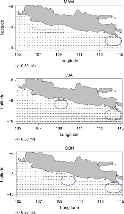
The decrease in sea level in the southern waters of Java during the upwelling process are not uniform; the highest decrease occurs in the south of East Java and the lowest decrease occurs in the south of West Java. The cause of the significant difference in sea level decline during upwelling is the eddy currents in the southern waters of East Java and Central Java, as shown in Fig. 5. These eddy currents move in a clockwise direction. Because these eddy currents are located in the southern hemisphere, they cause divergence. This divergence process causes the upwelling intensity in the southern waters of East Java and Central Java to strengthen. Eddy currents increase primary productivity up to 2–8 times (Kumar et al. 2004).
|
In the MAM season, eddy currents only formed in the southern waters of East Java, with dimensions of 144.3 × 77.7 km and a speed of about 0.17 m/s. This eddy current strengthened upwelling in the southern waters of East Java, so the decrease in sea level was greatest in the MAM season. During the JJA–SON season, eddy currents formed in the southern waters of East Java and Central Java. The dimensions of the eddy currents in the southern waters of Central Java were 111 × 33.3 km with speeds ranging from 0.12 m/s in the JJA season to 0.09 m/s in the SON season. Meanwhile, the dimensions of the eddy flow in southern East Java were 144.3 × 77.7 km with speeds of 0.33 m/s in the JJA season and around 0.23 m/s in the SON season. The sizes and velocities of the eddy currents in the waters south of East Java were greater than those south of Central Java, so the upwelling south of East Java was stronger than south of Central Java. These results support the research from Kuswardani and Qiao (2014), who stated that when upwelling occurs in the south of Java, the vertical velocity in the south of East Java is stronger than in the south of Central Java and West Java.
Fig. 6 shows the annual anomalies. It can be seen that, in general, in any season, SLAs tended to increase from year to year. In certain years, the sea level fluctuation in the southern sea of Java was very high. The intensity of sea level fluctuation in the JJA and SON seasons were greater than in the DJF and MAM seasons, as shown in Fig. 6. The sea level fluctuation range in the DJF and MAM seasons was from −13.39 to 14.93 cm, while in the JJA and SON seasons, it ranged from −26.91 to 29.24 cm. Significant increases in sea level occurred in 1998, 2010 and 2016 along with negative IOD phases and La Niña events. Significant decreases occurred in 1994, 1997 and 2006 along with positive IOD phases and El Niño events.

|
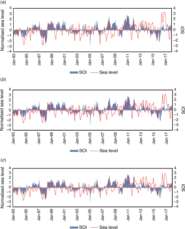
To see the influence of ENSO on sea level variability in southern Java, time series analysis and correlation of SOI and sea level were carried out. Sea level data need to be normalised so that the seasonal effect on this data disappears. The normalised data was used to determined how the influence of interannual phenomena, such as ENSO, on sea level condition. The mean sea level data was removed, and after that, the results were divided by standard deviation. In Fig. 7, a trend can be seen in normalised sea level values that is directly proportional to SOI and values. When the SOI value tends to be positive, the sea level values are also positive. This means that when La Niña events occurred, there was a tendency for sea level to increase in the southern regions of Java, West Java, Central Java, and East Java. On the other hand, when El Niño events occurred, sea level tended to decrease from the average.
|
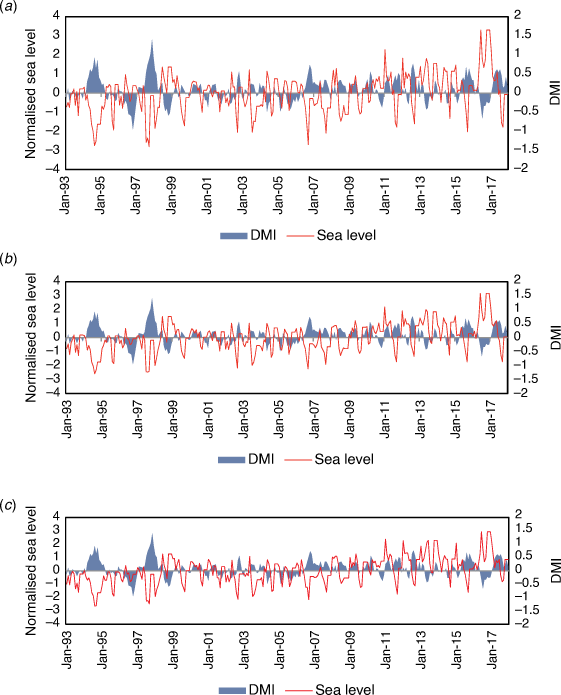
The same method was used for IOD events, where the DMI value was plotted with normalised sea level data. It can be seen that there is an inversely proportional trend in the data, where sea level rise tended to be associated with negative DMI/negative IOD values (Fig. 8). In contrast, the incidence of positive IOD (positive DMI) tended to be associated with a decrease in sea level.
|
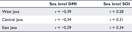
Based on Table 1, the range of correlation values between sea level normalisation and DMI (or IOD incidences) was from r = −0.39 to r = −0.29. South of West Java had the strongest correlation value of r = −0.39, followed by Central Java with r = −0.34 and East Java with r = −0.29. The negative sign indicates that the opposite condition between the positive IOD events was closely related to a decrease in sea level, and vice versa. Contrary to DMI, the correlation between SOI (ENSO incidences) and normalised sea level data was strongest in East Java with a value of r = 0.34, followed by Central Java with r = 0.28, and West Java with r = 0.31, while all locations had positive values.
|
SLAs in 1994, 1997, 1998, 2006, 2010 and 2016 are shown in Fig. 9. The significant increases in sea level in 2010 and 2016 coincided with the incidence of negative phases of IOD, while in 1998, lowered sea level coincided with the incidence of a negative phase IOD and a La Niña event. The average sea level rise between June and November in 1998 was about 9.2 cm; in 2010, it was 11.3 cm, and in 2016 it was around 19.4 cm. The significant decreases in 1994 and 2006 coincided with the incidence of positive phases of IOD, whereas in 1997, lowered sea level coincided with a positive phase of IOD and an El Niño event. The average decline between June and November in 1994 was about −17.6 cm; in 1997, it was around −18.4 cm, and in 2006 it was around −11.7 cm. This is in line with the description by Nababan et al. (2015), which stated that sea levels will be extremely low when there is an El Niño event with a minimum SOI that coincides with a positive IOD. On the other hand, sea level will be higher when there is a La Niña event with a maximum SOI along with a negative IOD.

|
In 2015, when El Niño was strong, the average decrease in sea level between June and November was only about −3.5 cm. This shows that the influence of IOD on changes in sea level in the southern sea of Java was stronger than the effect of ENSO. The influence of IOD was stronger because the southern sea of Java is very close to the Southeastern Tropical Indian Ocean sea surface temperature index, so the highest and lowest sea level increases and decreases occurred south of East Java.
Cross-correlation value data of ENSO and SLAs with a lag time from −10 to +10 months is presented in Fig. 10. Fig. 10 shows that, in all locations, the highest correlation was in the lag time of 1 month. This means that ENSO events (El Niño and La Niña) were followed by changes in sea level 1 month after the ENSO event occurred. The highest correlation occurred in East Java with a lag time value of 1 month. The correlation value at that time was 0.50 ± 0.10. At the same time (lag time 1 month), the smallest correlation value was in West Java, which was 0.42 ± 0.10. This means that the further west a location was in southern Java, the more the influence of ENSO on sea level rise decreased. Fig. 11 also shows that, for all lag times, the further west the coastal location was, the smaller the correlation coefficient value. In this case, the correlation value for the overall lag time in West Java (Fig. 10a) was, on average, smaller than the correlation value for the overall lag time in Central Java (Fig. 10b). The largest correlation value for the overall lag time occurred in East Java (Fig. 10c).

|

|
At lag 0, the correlation value in West Java was around 0.28 ± 0.10; in Central Java, it was around 0.41 ± 0.10, and in East Java, it was 0.43 ± 0.10. If we look at these three locations, the average correlation was around 0.38. This correlation value is moderate, which means that in lag 0 time conditions, the ENSO phenomenon had a sufficient influence on fluctuations in the sea level rise value in southern Java.
Cross-correlation value data of IOD and SLAs with a lag time from −10 to +10 months is presented in Fig. 11. Fig. 11 shows that for southern West Java, the highest correlation value occurred when IOD and sea level were within lag 0, meaning that, under these conditions, it is estimated that the IOD event directly affected the sea level condition. In this situation, the correlation value between DMI and sea level reached −0.39. This means that the sea level in southern Java tended to decrease when a positive IOD event occurred and vice versa.
In the southern Central Java and southern East Java areas, the strongest correlation value was experienced with a lag −1 condition, even though the difference was very small compared to the lag 0 time. From all conditions, the strongest correlation was in the southern part of West Java, with a correlation value reaching −0.39 (Fig. 11a), followed by Central Java at lag −1, which reached −0.34 (Fig. 11b), and East Java at lag −1, which reached −0.29 (Fig. 11c).
The values above indicate that in the southern West Java area, the sea level condition in this area changed rapidly with the occurrence of an IOD event. Meanwhile, in southern Central Java and southern East Java, where the highest correlation with DMI occurred at lag −1, the effect of IOD on sea level tended to be felt 1 month after the IOD event occurred.
The effect of ENSO on upwelling in the southern waters of Java is closely related to Indonesian Throughflow transport (Susanto et al. 2001). During an El Niño period, the water mass supply through Indonesia Throughflow becomes reduced so that the depth of the thermocline in southern Java shoals. The lifting of the thermocline strengthens the upwelling intensity so that the decrease in sea level is greater. On the other hand, during La Niña events, Indonesian Throughflow transport strengthens and the water mass supply from the Pacific Ocean to the southern waters of Java increases. The addition of water causes the thermocline in southern Java to deepen. The deeper the thermocline, the weaker the upwelling intensity, so the SLA is higher.
The significant increase and decrease in sea level during IOD events is related to changes in wind intensity in the Indian Ocean. When the positive phase of IOD occurred in 1994, the eastward equatorial jets in the Indian Ocean weakened, which resulted in the sea level in the eastern part of the Indian Ocean, including the west coast of Sumatra and south of Java, decreased and the thermocline shallowed (Vinayachandran et al. 1999). The decrease in sea level in 1997 was influenced by an increase in the intensity of surface winds on the west coast of Sumatra of 2–3 m/s from normal conditions (Webster et al. 1999). This increase in wind speed strengthened the upwelling intensity from the south coast of Java to the west coast of Sumatra. In 1998, downwelling on the south coast of Java was the cause of sea level rise.
Based on data for period 1993–2013, the variance of sea level in southern Java reached 0.0041, while globally it was only 0.00054. This means that sea level in southern Java had higher variance and rate of change compared to the global scale. This may be because of the differences in mechanisms of sea level rise between global and regional scales.
The spatial plot of the annual sea level rise in southern Java is presented in Fig. 12. It can be seen that annual sea level rise in southern Java range from 4 to 5 mm/year. The lowest increase occurred in southern West Java, while the highest increase occurred in southern Central Java and southern East Java.

|
Satellite altimeter data for the period 1993–2018 shows the sea level in the southern waters of Java has an upward trend of about 4.7 mm/year. This is higher than some other research results. The average global height increase was about 3.2 mm/year in the last two decades. For the period 1993–2013, the average sea level rise along the Australian coast was about 3.1 mm/year (McInnest et al. 2015). Sea level change around the northern Australian coastline exhibited an overall rise of 6.3 ± 1.4 mm/year and 6.1 ± 1.3 mm/year from tide gauge and altimetry data for 1993–2013 (Gharineiat and Deng 2018). The average sea level rise on the coast of Cilacap (southern Java) for the 2003–2010 period from satellite altimeter data and tide was around 3.5 mm/year (Mansawan et al. 2016). As an archipelago country, the probability of sea level rise in Indonesia is higher than the global average (Han et al. 2010).
4 Conclusion
The seasonal variation in sea level in the waters south of Java is influenced by the Asian–Australian monsoon, while the interannual variation is influenced by the incidence of IOD and ENSO. At the beginning of the MAM season, the sea level decreased to reach a maximum in the SON season. This decrease in sea level was closely related to the upwelling in southern Java and the formation of eddy currents in southern Central Java and East Java. The effect of IOD and ENSO on sea level fluctuations was closely related to changes in surface wind intensity in the eastern part of the Indian Ocean and Indonesian Throughflow transport. The sea level rise coincided with negative phases of IOD and La Niña events, while a significant decrease coincided with a positive phase of IOD and an El Niño event. The southern waters of West Java are part of the Tropical Indian Ocean, so the influence of IOD is stronger than ENSO. The trend of increasing average sea level in the waters of southern Java from 1993 to 2018 was around 4.7 mm/year.
Data availability
All datasets used for this research are available to the public and can be accessed through the links described in Section 2.1 of this paper.
Conflicts of interest
The authors declare no conflicts of interest.
Declaration of funding
This research did not receive any specific funding.
Acknowledgements
We would like to thank Center of Atmospheric Research and Technology, National Research and Innovation Agency for providing support for the completion of this research.
References
ADB (2016) Indonesia: country water assessment. Asian Development Bank (ADB), Mandaluyong City, Philippines. Available at https://www.adb.org/documents/indonesia-country-water-assessmentBicknell C (2010) Sea level change in Western Australia. Department of Transport Coastal Infrastructure, Coastal Engineering Group.
Church JA, Hunter JR, McInnes KL, White NJ (2006) Sea-level rise around the Australian coastline and the changing frequency of extreme sea-level events. Australian Meteorological Magazine 55, 253–260.
Church JA, Clark PU, Cazenave A, Gregory JM, Jevrejeva S, Levermann A, Merrifield MA, Milne GA, Nerem RS, Nunn PD, Payne AJ, Pfeffer WT, Stammer D, Unnikrishnan AS (2013) Sea level change. In ‘Climate change 2013: the physical science basis. Contribution of working group I to the fifth assessment report of the intergovernmental panel on climate change’. (Eds TF Stocker, D Qin, G-K Plattner, M Tignor, SK Allen, J Boschung, A Nauels, Y Xia,V Bex, PM Midgley) pp. 1137–1216 (Cambridge University Press: Cambridge).
Douglas BC (1991) Global sea level rise. Journal of Geophysical Research: Oceans 96, 6981–6992.
| Global sea level rise.Crossref | GoogleScholarGoogle Scholar |
Fadlan A, Sugianto DN, Kunarso , Zainuri M (2017) Influence of ENSO and IOD to Variability of Sea Surface Height in the North and South of Java Island IOP Conference Series: Earth and Environmental Science 55, 012021
| Influence of ENSO and IOD to Variability of Sea Surface Height in the North and South of Java IslandCrossref | GoogleScholarGoogle Scholar |
Fenoglio-Marc L, Schöne T, Illigner J, Becker M, Manurung P, Khafid (2012) Sea level change and vertical motion from satellite altimetry, tide gauges and GPS in the Indonesian region. Marine Geodesy 35, 137–150.
| Sea level change and vertical motion from satellite altimetry, tide gauges and GPS in the Indonesian region.Crossref | GoogleScholarGoogle Scholar |
Gharineiat Z, Deng X (2018) Description and assessment of regional sea-level trends and variability from altimetry and tide gauges at the northern Australian coast. Advances in Space Research 61, 2540–2554.
| Description and assessment of regional sea-level trends and variability from altimetry and tide gauges at the northern Australian coast.Crossref | GoogleScholarGoogle Scholar |
Han W, Meehl GA, Rajagopalan B, Fasullo JT, Hu A, Lin J, Large WG, Wang J-w, Quan X-W, Trenary LL, Wallcraft A, Shinoda T, Yeager S (2010) Patterns of Indian Ocean sea-level change in a warming climate. Nature Geoscience 3, 546–550.
| Patterns of Indian Ocean sea-level change in a warming climate.Crossref | GoogleScholarGoogle Scholar |
Hecht JE (2016) Indonesia: costs of climate change 2050. Policy brief. Climate Change Adaptation Thought Leadership, and Assessments. United States Agency for International Development (USAID). Available at https://www.climatelinks.org/sites/default/files/asset/document/Indonesia%20Costs%20of%20CC%202050%20Policy%20Brief.pdf
Kumar SP, Nuncio M, Narvekar J, Kumar A, Sardesai S, de Souza SN, Gauns M, Ramaiah N, Madhupratap M (2004) Are eddies nature’s trigger to enhance biological productivity in the Bay of Bengal? Geophysical Research Letters 31, L07309
| Are eddies nature’s trigger to enhance biological productivity in the Bay of Bengal?Crossref | GoogleScholarGoogle Scholar |
Kuswardani RTD, Qiao F (2014) Influence of the Indonesian throughflow on the upwelling off the east coast of South Java. Chinese Science Bulletin 59, 4516–4523.
| Influence of the Indonesian throughflow on the upwelling off the east coast of South Java.Crossref | GoogleScholarGoogle Scholar |
Li X, Rowley RJ, Kostelnick JC, Braaten D, Meisel J, Hulbutta K (2009) GIS analysis of global impacts from sea level rise. Photogrammetric Engineering & Remote Sensing 75, 807–818.
| GIS analysis of global impacts from sea level rise.Crossref | GoogleScholarGoogle Scholar |
Mansawan AA, Lumban-Gaol J, Panjaitan JP (2016) Variation and trend of sea level derived from altimetry satellite and tide gauge in Cilacap and Benoa coastal areas. International Journal of Remote Sensing Earth Sciences 13, 59–66.
Marfai MA (2014) Impact of sea level rise to coastal ecology: a case study on the northern part of Java Island, Indonesia. Quaestiones Geographicae 33, 107–114.
| Impact of sea level rise to coastal ecology: a case study on the northern part of Java Island, Indonesia.Crossref | GoogleScholarGoogle Scholar |
McInnes KL, Church J, Monselesan D, Hunter JR, O’Grady JG, Haigh ID, Zhang X (2015) Information for Australian impact and adaptation planning in response to sea-level rise. Australian Meteorological and Oceanographic Journal 65, 127–149.
| Information for Australian impact and adaptation planning in response to sea-level rise.Crossref | GoogleScholarGoogle Scholar |
Measey M (2010) Indonesia: a vulnerable country in the face of climate change. Global Majority E-Journal 1, 31–45.
Meyssignac B, Cazenave A (2012) Sea level: a review of present-day and recent-past changes and variability. Journal of Geodynamics 58, 96–109.
| Sea level: a review of present-day and recent-past changes and variability.Crossref | GoogleScholarGoogle Scholar |
Nababan B, Hadianti S, Natih N (2015) Dynamic of sea level anomaly of Indonesian waters (in Bahasa Indonesia). Journal Ilmu dan Teknologi Kelautan Tropis 7, 259–272.
| Dynamic of sea level anomaly of Indonesian waters (in Bahasa Indonesia).Crossref | GoogleScholarGoogle Scholar |
Nicholls RJ (2003) Case study on sea level rise impacts. OECD workshop on the benefits of climate policy: improving information for policy makers. Organisation for Economic Co-operation and Development, France.
Ningsih NS, Rakhmaputeri N, Harto AB (2013) Upwelling variability along the southern coast of Bali and in Nusa Tenggara Waters. Ocean Science Journal 48, 49–57.
| Upwelling variability along the southern coast of Bali and in Nusa Tenggara Waters.Crossref | GoogleScholarGoogle Scholar |
Oliver-Smith A (2009) ‘Sea level rise and the vulnerability of coastal peoples: responding to the local challenges of global climate change in the 21st century’. (Interdisciplinary Security Connections, Publication Series of UNU-EHS, No. 7: Bonn)
Qu T, Du Y, Strachan J, Meyers G, Slingo J (2005) Sea surface temperature and its variability in the Indonesian region. Oceanography 18, 50–61.
| Sea surface temperature and its variability in the Indonesian region.Crossref | GoogleScholarGoogle Scholar |
Siebentritt M (2016) ‘Understanding sea-level rise and climate change, and associated impacts on the coastal zone. CoastAdapt Information Manual 2’. (National Climate Change Adaptation Research Facility: Gold Coast)
Sofian I (2010) Scientific basis: analysis and projection of sea level rise and extreme weather event. Indonesia Climate Change Sectoral Roadmap, Bappenas.
Susanto RD, Marra J (2005) Effect of the 1997/98 el niño on chlorophyll a variability along the Southern Coasts of Java and Sumatra. Oceanography 18, 124–127.
| Effect of the 1997/98 el niño on chlorophyll a variability along the Southern Coasts of Java and Sumatra.Crossref | GoogleScholarGoogle Scholar |
Susanto RD, Gordon AL, Zheng Q (2001) Upwelling along the coasts of Java and Sumatra and its relation to ENSO. Geophysical Research Letters 28, 1599–1602.
| Upwelling along the coasts of Java and Sumatra and its relation to ENSO.Crossref | GoogleScholarGoogle Scholar |
Triana K, Wahyudi AJ (2020) Sea Level Rise in Indonesia: The Drivers and the Combined Impacts from Land Subsidence ASEAN Journal on Science and Technology for Development 37, 115–121.
| Sea Level Rise in Indonesia: The Drivers and the Combined Impacts from Land SubsidenceCrossref | GoogleScholarGoogle Scholar |
Vinayachandran PN, Saji NH, Yamagata T (1999) Response of the Equatorial Indian Ocean to an unusual wind event during 1994. Geophysical Research Letters 26, 1613–1616.
| Response of the Equatorial Indian Ocean to an unusual wind event during 1994.Crossref | GoogleScholarGoogle Scholar |
Webster PJ, Moore AM, Loschnigg JP, Leben RR (1999) Coupled ocean-atmosphere dynamics in the Indian Ocean during 1997-98. Nature 401, 356–360.
| Coupled ocean-atmosphere dynamics in the Indian Ocean during 1997-98.Crossref | GoogleScholarGoogle Scholar | 16862107PubMed |
White NJ, Haigh ID, Church JA, et al (2014) Australian sea levels—Trends, regional variability and influencing factors Earth-Science Reviews 136, 155–174.
| Australian sea levels—Trends, regional variability and influencing factorsCrossref | GoogleScholarGoogle Scholar |
Wirasatriya A, Setiawan RY, Subardjo P (2017) The Effect of ENSO on the Variability of Chlorophyll-a and Sea Surface Temperature in the Maluku Sea IEEE Journal of Selected Topics in Applied Earth Observations and Remote Sensing 10, 5513–5518.
| The Effect of ENSO on the Variability of Chlorophyll-a and Sea Surface Temperature in the Maluku SeaCrossref | GoogleScholarGoogle Scholar |
Wyrtki K (1961) ‘Physical oceanography of the southeast Asian waters’. (The University of California Scripps Institution of Oceanography: La Jolla, CA)
Zhang X, Church JA (2011) Linear trend of regional sea‐level change in the Pacific Ocean and its relationship with background decadal oscillation. Paper presented at International Union of Geodesy and Geophysics General Assembly, Melbourne, Victoria, Australia.
Zikra M, Suntoyo , Lukijanto (2015) Climate change impacts on Indonesian coastal areas. Procedia Earth and Planetary Science 14, 57–63.
| Climate change impacts on Indonesian coastal areas.Crossref | GoogleScholarGoogle Scholar |