
Synoptic structure of severe Zonda downslope windstorms in Argentina
Federico Otero A * , Diego Araneo A and Maximiliano Viale A
A
Abstract
The Zonda wind is a characteristic Argentinian downslope windstorm that occurs on the eastern slopes of the Andes Mountains, creating extremely windy, warm and dry conditions with substantial socioeconomic impacts. This study aims to characterise and understand the synoptic-scale atmospheric dynamics, as well as the vertical structure of the atmosphere on both sides of the Andes, associated with severe and long-duration Zonda events compared with non-severe events. Severe events are most frequent between August and October, comprising 64.8% of occurrences. These events exhibit earlier onset and later cessation, resulting in more late-night and morning Zonda hours compared with non-severe events. The synoptic structure for severe and long Zonda events is associated with a more baroclinic structure, featuring a deep trough at both low and mid-levels and shifted west with altitude. Lower levels present higher anomalies and move faster than mid-level anomalies when the wind crosses the Andes. This is accompanied by a deep trough east of the Andes with a tilted axis and a slower eastward movement. The associated upper-level dynamic shows a stronger convergence and divergence pattern on the windward and lee sides of the Andes respectively, along with a stronger, elongated and persistent jet streak. The precipitation pattern is in agreement with the more intense winds impinging on the Andes, resulting in more intense rising motions and more precipitation on the windward slopes. Analysis of the vertical structure in severe events shows a more humid windward profile, especially at low and mid-levels, with stronger winds. The leeward side presents a more unstable temperature profile, warmer at low levels and colder at upper levels, and extreme dryness between low and mid-levels, indicating the presence of the Zonda at this altitude before the event starts. Given the limited studies on Zonda downslope windstorms in South America, this research represents a major step in our understanding of these severe events and provides valuable insights for weather forecasters.
Keywords: Andes, Argentina, atmospheric dynamics, pressure systems, severe foehn, standarised anomalies, synoptic circulation, Zonda wind.
1.Introduction
Zonda is a powerful, warm, extremely dry and gusty wind occurring on the eastern slopes of the Andes Mountains in Argentina. This downslope windstorm is a mesoscale phenomenon generally known as a foehn wind in the European Alps, where the name comes from (Hoinka 1985; Seibert 1990; Würsch and Sprenger 2015). These winds are very common around the world, including the Chinook winds near the Rocky Mountains (Glennf 1961; Lilly and Klemp 1979; Nkemdirim 1986; Oard 1993), the Santa Ana winds near the mountains of southern California (Burroughs 1987; Raphael 2003), the Puelche and Raco in Chile (Montecinos et al. 2017; Beusch et al. 2018; Muñoz et al. 2020), the Inami-kaze in Japan (Koyanagi and Kusaka 2020) and the north-westerly in the Southern Alps, New Zealand (McGowan and Sturman 1996; McGowan et al. 2002), among others. These winds have drawn research interest owing to their significant socioeconomic impacts, which range from risks to infrastructure and aviation to increased wildfire hazard (Sharples et al. 2010; Richner and Hächler 2013). They also cause a series of damages depending on the intensity of the wind gusts, such as roof damage and tree and high-voltage power line collapse, as well as the interruption of communication systems. They also promote the start and spread of fires and damage crops because of the intense wind, sudden dryness and high temperatures.
Various classifications of foehn winds have been developed over time. The earliest form of foehn was described by Hann (1866), which Jansing et al. (2022) refer to as dry foehn, when precipitation upwind of the topographic barrier does not occur. In the scientific literature on Alpine foehn, an important distinction is made between deep foehn and shallow foehn. A foehn is named deep when the cross-Alpine synoptic flow extends significantly above the height of the Alpine crest (e.g. Seibert 1990). By contrast, the shallow foehn is associated with cross-Alpine temperature differences that promote gap flow of cold air in the south, which plays an important role in generating this type of foehn (Gohm et al. 2004; Jansing et al. 2022). Studies have re-emphasised the key role of the lee-side adiabatic compression of air originating from elevated upstream levels being decoupled from the blocked air mass underneath (e.g. Seibert 1990). Elvidge et al. (2016) and Miltenberger et al. (2016) referred to this process as the ‘isentropic drawdown’ mechanism, but there are other factors such as diabatic heating due to latent heat release, solar irradiation, surface fluxes and downward mixing of potentially warmer air (Elvidge and Renfrew 2016). By contrast, the ‘dimmerfoehn’ occurs when the foehn wall extends downwind of the topographic barrier, resulting in precipitation over lee slopes and valleys (Richner and Hächler 2013). The pronounced case-to-case differences, as observed during the Mesoscale Alpine Programme (Bougeault et al. 2001), indicate that isentropic drawdown or latent heating can both govern foehn air warming.
Synoptic-scale atmospheric conditions play a key role in triggering and shaping foehn wind events. Different approaches have further demonstrated that synoptic fingerprints from reanalysis data can effectively predict foehn occurrences, as shown in Swiss studies by Mony et al. (2021) and Drechsel and Mayr (2008). These patterns often include a trough and an upstream jet streak, which align perpendicular to the mountain barrier and drive strong cross-barrier winds (Richner and Hächler 2013). Seasonal and diurnal variations further influence foehn frequency and duration, as observed in Alpine valleys, where foehn events often occur with deep southerly flow preceding cold fronts (Sprenger et al. 2016). In the study conducted by Lentink (2012), the author shows that extreme foehn events are associated with so called jet streaks, as long as the exit area is located near the Alps, marking a difference between long and short extreme foehn events. Lentink also found that longer foehn event durations have relatively stronger wind gusts. The influence of these synoptic conditions varies seasonally and diurnally, as shown in Alpine studies where foehn events are often preceded by southerly flows and cold fronts (Sprenger et al. 2016). Examining this scenario, Otero and Araneo (2023) applied a statistical prediction model to find the synoptic fingerprints (as well as for the vertical soundings to both sides of the Andes in Otero and Araneo 2022) for Zonda winds for Mendoza and San Juan cities.
The most extensive climatological study of events classified as ‘severe’ Zonda was conducted over 30 years ago by Norte (1988) based on wind gust criteria using only 10 years of data. According to his findings, severe Zonda winds occur primarily in July and have distinct characteristics, including night-time or early morning onset and higher cross-barrier pressure gradients. However, this early work does not fully capture the variability of these events or provide a detailed analysis of their vertical structure and atmospheric dynamics. Later, Seluchi et al. (2003a) analysed three typical Zonda events of different categories through observational data and the Eta model. Among these events, the authors present the characteristics of a severe case occurring in Mendoza and San Juan. This event lasted 10 h with a maximum wind gust of 40 knots (~74 km h–1). They found that the intense pressure gradient across the Andes, north of 35.8°S, is a consequence of the deep lee depression and the anticyclone over the Pacific Ocean. This cross-Andes pressure gradient is locally intensified by the mesoscale effect of mountain waves and related to a depression that crossed the Andes with the proximity of an upper-level trough. The zonal pressure gradient maximum occurred when the front was immediately south of Mendoza. Another severe event was studied by Norte et al. (2008). Apart from the synoptic surface and upper-air conditions, which were those typically associated with a severe Zonda wind occurrence, they found the presence of the North West Argentine Low (NAL, Seluchi et al. 2003b) in central west Argentina during the hours following the event. Despite these advances, there is limited recent climatology on severe events, and none for long-duration Zonda events.
Although the works of Seluchi et al. (2003a) and Norte et al. (2008) provided foundational insights into severe Zonda wind, in these works only particular case studies were analysed and they were not examined in a climatological sense in order to provide statistical consistency. Our study uniquely highlights the mechanisms behind long-duration severe Zonda events in a climatological sense, providing a more detailed understanding of their dynamics, persistence and impacts, also differentiating severe and non-severe events in terms of intensity, timing and spatial characteristics, offering a more comprehensive understanding of the evolution and severity of Zonda winds. This focus fills a gap in the literature and extends the knowledge of Zonda behaviour, especially in the context of orographic and synoptic interactions. This comparative approach highlights how this research complements and extends the existing literature on Zonda winds. The structure of this paper is as follows: Section 2 describes the data and the applied methodology, where classification criteria for severe or non-severe Zonda events are shown. Section 3 presents the climatology of long-duration severe Zonda events, the synoptic patterns, the vertical structure and cross-section analysis. Finally, Section 4 discusses the results and presents the conclusions.
2.Data and methodology
2.1. Data
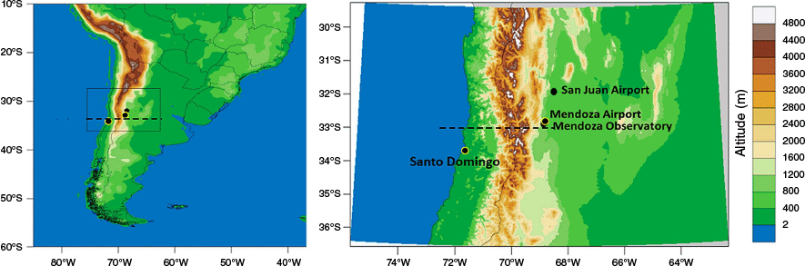
The Zonda wind classification is created using hourly data from the 1981 to 2023 period from three surface stations on the lee side of the Andes (Fig. 1, black dots) belonging to the National Weather Service of Argentina (Servicio Meteorológico Nacional, SMN). These are Mendoza Airport (32.83°S, 68.8°W, 704 m above sea level, ASL), Mendoza Observatory (32.9°S, 68.866°W, 827 m ASL) and San Juan Airport (31.56°S, 68.5°W, 598 m ASL). The selection of these surface stations is based on two main reasons: first, they are located in the most populated cities affected by the phenomenon, and second, they are the only official stations that provide reliable data for research. The Zonda wind, a mesoscale event, varies in spatial extent and duration, often affecting one location while sparing nearby areas owing to the complex central Andes orography. Although the distributions of events differ between stations, they share many occurrences. To analyse the associated synoptic conditions, the authors use data from three official synoptic stations. Including all stations provides a larger data set for synoptic-scale analysis.
South America region with topographic height (shading) and zoomed-in region over surface weather stations. Black dots surrounded in yellow and yellow lines correspond to sounding stations and black dots correspond to the stations used for Zonda wind classification. Dashed line corresponds to the cross-section analysis. Figure adapted from Otero and Araneo (2021). The distance north–south from Mendoza to San Juan is 170 km.
Also, we make use of the ERA5 reanalysis data (Hersbach et al. 2020). This data set is the fifth generation of European Centre for Medium Range Weather Forecasting (ECMWF) global atmospheric reanalysis. The current ERA5 data span is from 1940 onward. Its horizontal resolution is ~30 km and it computes atmospheric variables at 39 pressure levels (137 model levels). The area considered for this study is 20–50°S, 50–90°W. In total, this represents a grid with 19481 grid points. Next, we consider atmospheric fields at surface, sea level and several pressure levels (1000, 925, 850, 700, 500, 400, 300 and 200 hPa).
2.2. Methodology
Alpine foehn has an important distinction between different types of foehn, which differ distinctively in the synoptic conditions over the Alps. Jansing et al. (2022) differentiated among three main foehn types (deep foehn, shallow foehn and gegenstrom foehn). In addition, they used upstream precipitation and its extent beyond the Alpine crest as criteria to distinguish three deep foehn subtypes (dry foehn, moist foehn, dimmerfoehn). The present work does not intend to make such a distinction about the type of foehn, either by its synoptic distinction or the associated heating process. Furthermore, there are no previous works that have made this type of classification for the Andes. So here, we consider all Zonda events that reach the surface, leaving the different foehn types (and the associated dynamics and heating process) to be investigated in future studies. In previous studies, terms like ‘foehn event’ and ‘foehn period’ were used interchangeably, but the timing of foehn winds is not always consistent, leading to issues with such broad classifications. Earlier climatologies were often measured based on hours, parts of days, or entire days (Widmer 1966; Gutermann 1970; Richner and Gutermann 2007).
The methodology for defining Zonda events follows the approach used in Otero and Araneo (2021), which resulted in a high-performance model using supervised machine learning (ML) algorithms. Training and supervision are based on the subjective Zonda wind classification (expert classification; see Mayr et al. 2018 for more detail) by assessing the total hourly data that correspond to Zonda wind observations. A Zonda is considered an event if at least 1 h is classified. The predictor variables employed in the present study are temperature (T), dew point temperature (Td), surface pressure (P) and 10-m wind speed (V). We employ the k nearest neighbours (k-NN) algorithm, which has a probability of detection (POD) of well-classified Zonda of 91.61% and a correct alarm ratio (CAR) of 93.18%. It also has a lower probability of false detection (POFD) and missing ratio (MR), as well as the best result in alarm-based perspective metrics. This algorithm is applied using monthly–daily anomalies, a calculation obtained by considering the monthly mean cycle at an hourly scale, that is, a ‘mean 24-h day for each month of the year’. This study defines separate events when they are interrupted by at least 6 h (commonly owing to passing frontal systems and change in the air mass). Short interruptions are considered part of the same Zonda event. Also, owing to the objective here being mostly based on the synoptic scale and given the proximity of the stations, an event is selected if it occurs at any of the three surface stations. The ERA5 data are used here every 6 h (0:00, 6:00, 12:00 and 18:00 hours Coordinated Universal Time, UTC), so after finding all Zonda events, we define the event hour as the closest hour prior to the event onset (i.e. if the event starts at 15:00 hours UTC, the event hour will be 12:00 hours UTC of that same day), −6 h before the event onset (6:00 hours UTC of that day), the 6 h after the event onset (18:00 hours UTC of that day) and the 12 h after the event onset (0:00 hours UTC of the next day). Considering all three stations, a total of 324 Zonda events were identified.
The severity of a Zonda event can be defined in different ways. For example, Lentink (2012) proposes the top 10% of different variables, including duration, extreme jump in temperature, abrupt decrease in humidity or cross-Alpine pressure difference, as well as the average values during the event, among others. Even so, the author finds that there is no perfect extreme foehn event (i.e. total correlation of extreme variables does not exist) and therein lies the difficulty of the definition. For this reason, the present study proposes using only the variables of duration and speed, which are highly related. This decision is based on the fact that extreme wind is usually the variable that causes the greatest amount of damage.
So, from the wind speeds recorded on an hourly basis (knots) at each meteorological station, the maximum records for each Zonda wind event are determined. For each station, the frequency distributions of these maximum winds per event are fitted to different probability distributions in order to define percentiles with major robustness and accuracy. The three theoretical probability distributions that best fit the observed frequencies were determined from the Anderson–Darling criterion and inspection of the probability plots. All of these fits were found to be statistically significant at the 5% confidence level. We consider severe Zonda wind events to be those in which the maximum recorded hourly wind speed exceeds the 0.75 percentile, which is equivalent to a wind above 21 kt (~10.8 m s−1) for Mendoza and 26 kt (~13.4 m s−1) for San Juan (Table 1). For the duration of the events, we also consider the 0.75 percentile, namely 9 h for Mendoza Airport, 8 h for Mendoza Observatory and 13 h for San Juan Airport. Fig. 2 shows a scatter plot of the maximum wind and duration distributions for each event and station. The separation of the events follows those 75th percentiles in both variables and thus generates four categories: strong and long, weak and long, short and strong and short and weak, where the first adjective refers to duration and the second to wind speed. In this way, 37°S events are found from a total of 324. Most of the events correspond to the lowest category (i.e. short and weak); however there are several events that surpass the wind speed or duration thresholds but not both at the same time.
| Quantile | 0.20 | 0.25 | 0.40 | 0.50 | 0.60 | 0.75 | 0.80 | ||
|---|---|---|---|---|---|---|---|---|---|
| Mendoza Airport | Gamma | 10.2 | 11.1 | 13.5 | 15.1 | 16.9 | 20.1 | 21.5 | |
| 3-parameter lognormal | 10.4 | 11.3 | 13.7 | 15.3 | 17.0 | 20.1 | 21.4 | ||
| 3-parameter gamma | 10.3 | 11.2 | 13.7 | 15.3 | 17.0 | 20.1 | 21.5 | ||
| Mean percentile | 10.3 | 11.2 | 13.6 | 15.2 | 17.0 | 20.1 | 21.4 | ||
| Mendoza Observatory | 3-parameter Weibull | 9.1 | 10.2 | 13.3 | 15.4 | 17.5 | 21.4 | 23.0 | |
| Weibull | 9.2 | 10.3 | 13.5 | 15.6 | 17.8 | 21.6 | 23.1 | ||
| 3-parameter gamma | 9.4 | 10.4 | 13.3 | 15.2 | 17.3 | 21.1 | 22.7 | ||
| Mean percentile | 9.2 | 10.3 | 13.4 | 15.4 | 17.5 | 21.3 | 22.9 | ||
| Mendoza mean percentile | 10 | 11 | 14 | 15 | 17 | 21 | 22 | ||
| San Juan | Weibull | 13.8 | 15.1 | 18.5 | 20.6 | 22.7 | 26.3 | 27.7 | |
| Normal | 14.1 | 15.5 | 18.8 | 20.8 | 22.9 | 26.2 | 27.6 | ||
| 3-parameter Weibull | 13.8 | 15.0 | 18.3 | 20.4 | 22.5 | 26.2 | 27.6 | ||
| Mean percentile | 14 | 15 | 19 | 21 | 23 | 26 | 28 | ||
The row ‘Mendoza mean percentile’ shows the averages between the mean percentiles corresponding to Mendoza Airport and Mendoza Observatory, rounded to the nearest integer.
Distribution and scatter plot for the three selected stations. Maximum hourly wind speed per event distribution on the x-axis and duration on the y-axis. Tendency line and its standard deviation in blue. The coloured rectangles correspond to the different categories of Zonda events, which are separated by the 75th percentiles for each distribution according to Table 1: sky blue for weak and long, grey for weak and short, red for long and strong and yellow for long and weak events. (a) Mendoza Airport; (b) Mendoza Observatory; and (c) San Juan Airport.

When analysing the different proposed categories, both long- and short-strong events share several similarities in their synoptic characteristics. The deeper negative geopotential anomalies observed in strong events indicate a more intense synoptic forcing compared with weak events. Although there are some differences between long-strong and short-strong events, particularly at low levels, the short-strong events clearly exhibit a synoptic configuration that is more comparable with severe events than weak ones (figure not shown). For this reason, and considering that short-strong events represent hazardous conditions for locations affected by Zonda winds, we decided to remove them from the non-severe category. This adjustment reduces the total number of Non-Severe (NS) cases by 60 events, out of 284, accounting for ~20% of the sample. For simplicity, we apply the name Severe (S) to the long-strong events and NS to the short-weak and long-weak events together.
Although short-strong events share similar synoptic characteristics to long-strong events, there are also notable similarities between long and strong events, as well as between short and weak events. A comparison of long and short events at low levels reveals that long events exhibit more intense and persistent anomalies throughout their entire evolution. Similarly, strong events display much more intense anomalies than weak events, and like long events, these anomalies persist for a longer duration (figure not shown). Despite the differences between these categories, this study focuses on the relationship between synoptic-scale circulation and the longevity of strong Zonda wind events. Therefore, a detailed comparison of these classifications is beyond the scope of this work and they will not be further analysed or discussed here.
Departures from normal at each grid point are calculated by comparing meteorological fields or parameters against a 21-day running daily mean based on the average of the 41 years of ERA5 reanalysis data, centred on the specific day and hour of interest. Standard deviations are similarly based on this 21-day running mean, minimising monthly boundary biases. This method ranks extreme events (such as cyclones, cold spells and heat waves) according to how much they deviate from typical local values for the time of year, with rarer, more intense events receiving higher rankings. This approach accounts for synoptic-scale variability, meaning that an event with a fixed intensity will show a greater anomaly in summer than in winter. Extreme events, defined as those over 4 s.d. from the mean, have minimal impact on average values, allowing their frequency to remain largely independent of the annual cycle (Graham and Grumm 2010a; e.g. Hart and Grumm 2001; Stuart and Grumm 2006; Junker et al. 2008; Viale and Norte 2009; Viale and Nuñez 2011). With 6-hourly data, each mean and standard deviation is computed over the 10 days on either side (40 entries) plus the current hour, totalling 81 data points per grid point. Building on Graham and Grumm (2010b), the present study uses normalised anomalies to investigate where and when S Zonda events are likely to occur. The standardised departure of any meteorological variable can be defined by:
where X is the value of the variable (e.g. 500-hPa height), μ is the mean value (based on the 21-day running mean for all hours) for that grid point and σ is the standard deviation (based on the 21-day running mean for all hours) for each grid point.
3.Results
3.1. Climatology of long-strong severe Zonda events
Surface stations are analysed separately only for the diurnal and monthly cycles; thereafter, all events are considered as a single data set. Fig. 3a, c, e illustrates the monthly distribution of S and NS events across the three surface stations. At Mendoza Airport and Observatory, both event types peak in August and September, with secondary peaks in May and October. An additional July peak is observed at these stations but is absent at San Juan. At San Juan, the highest frequencies for S events occur in August and September, with no notable increase in July. When considering all stations combined, S events reach their maximum frequency between August and October, accounting for 64.8% of all S events, compared with 41.5% for NS Zonda events.
Relative frequency of monthly Zonda distribution of S events and N-S events and relative frequency of daily distribution of Zonda for each station. The data are expressed in UTC (local time is UTC – 3). NS events are in light orange and S in blue. (a, b) Mendoza Airport; (c, d) Mendoza Observatory; (e, f) San Juan Airport. Sunrise and sunset are marked for mid-August. Overlapping bars have a darker shade.

Fig. 3b, d, f shows the relative diurnal distributions, highlighting station-specific timing differences. NS events reach their maximum frequency during or shortly after the diurnal heating peak (20:00–2:00 hours UTC), with more pronounced peaks at the Mendoza stations compared with San Juan, where the maximum occurs earlier (18:00–22:00 hours UTC). By contrast, S events display distinct temporal patterns: at the Mendoza stations, their frequency is shifted earlier compared with NS events, peaking between 16:00 and 20:00 hours UTC, with more Zonda hours occurring from early morning to early afternoon. At San Juan, however, S events exhibit a delayed frequency shift, with more Zonda hours during the night compared with NS events.
These results emphasise the role of local dynamics and event severity in influencing timing, with S events generally showing an earlier onset and later cessation compared with NS events. The differences observed here can be attributed to several factors, like the availability and length of the data sets, which vary among the stations, the spatial separation between the stations (170 km) and the different duration of Zonda events between San Juan and Mendoza (Otero 2018).
3.2. Synoptic patterns
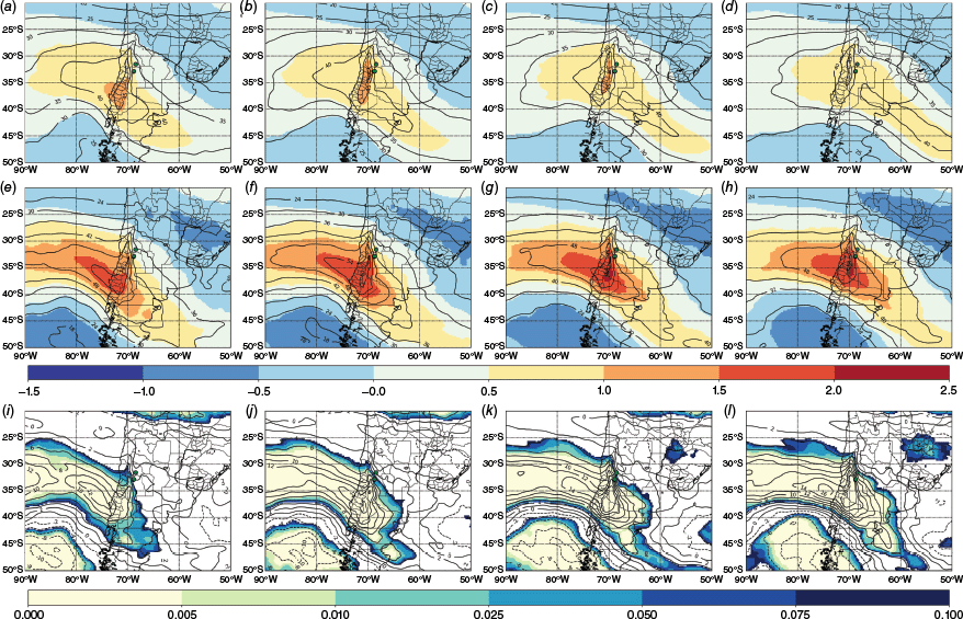
To evaluate the synoptic circulation differences between S and NS events, the standardised anomalies and their compositions in the reanalysis fields are calculated for both. By using these, we remove the stationarity of the events, which is very important in this case because winter events tend to be more extreme than the other seasons’ (Lentink 2012). Fig. 4 shows the evolution of 500-hPa geopotential standardised anomalies and the P-value of the t-student significance test for their differences (S − NS). This allows us to analyse the evolution of the systems as well as the intensity of the associated synoptic patterns.
Evolution of 500-hPa geopotential standardised anomalies (shaded, adimensional) and composition (black contours, m2 s−2) of (a–d) NS, and (e–h) S events. P-value for the t-student significance test (shaded, adimensional) and the difference (i–l) for S – NS (contours, m2 s−2). Columns in the figure correspond to different time frames relative to the events: 6 h before event onset, at the event hour, 6 h after event onset, and 12 h after event onset.

The NS events (Fig. 4a–d) present a negative anomaly at ~40°S with a standardised anomaly of less than −1.5 that persists for the entire period and crosses the Andes at ~+6 and +12 h. The geopotential shows an eastward propagating trough with its vertical axis over 77°W and with a maximum at −6 h. The trough axis is just behind the centre of negative anomalies. By contrast, in S events (Fig. 4e–h), a very deep trough with its axis slightly tilted in a NNW–SSE direction is noted at ~85°W. The negative anomaly is located at the front flank of the trough axis at 80°W. The anomaly reaches a standardised anomaly of −2 to −2.5 and is located 5° westward compared with the NS anomalies. The displacement of this deep trough persists with significant negative anomalies over the Andes up to 6 h after the event onset and begins to weaken and shift eastward ~12 h after the event onset.
The differences in geopotential contours are clearly noticeable, with values of more than 1000 m2 s−2 difference, mainly previous and close to event onset. The difference between S and NS is always significant at 99.5% and remains over the Pacific almost over the entire period; however, it reaches the surface stations 12 h before the event onset, indicating the prolonged impact of the S event (Fig. 4i–l) and the relatively (compared with NS events) slow displacement to the east.
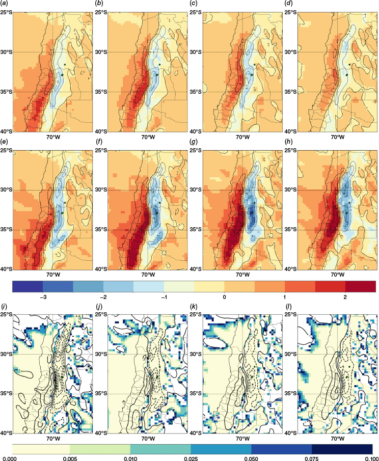
The analysis for 850 hPa is shown in Fig. 5. The trough at this level exhibits differences in intensity, position and displacement between S and NS events. In S events, the trough is deeper and remains over the Pacific pre-event and during event onset hours. Its intensity is also much deeper for S events and it even looks deeper than that of mid-levels (at least previous to and up to the onset of the event). Six hours after the event’s onset, it crosses the Andes, covering Argentinian Patagonia and advancing eastward faster than the mid-level system. By contrast, the trough in NS events progresses more quickly to the east, particularly after +6 and +12 h to event onset, with lower intensity and limited westward extension.

In terms of anomalies, S events at 850 hPa display stronger standardised anomalies than at mid-levels, with values reaching less than −3.5, approximately one standardised anomaly lower than at 500 hPa. At this level, the anomalies for both S and NS events are positioned closer to the Andes. The anomalies associated with S events propagate across the Andes more slowly and persist longer over the continental region compared with NS events. Another difference observed is that the anomaly shows a decrease in intensity after 6 h to event onset, unlike the 500-hPa ones, which retain almost the same intensity across the entire period.
The differences in geopotential between S and NS events exceed 800 m2 s−2 and are statistically significant at the 99.5% confidence level, and are located over the Pacific, but unlike mid-level (whose displacement is very low), they cross the Andes at the event hour, covering the whole of Patagonia, and move quickly to the north and west in the next hours (+6 and +12 h).
To summarise, all the previous analyses show that the most favourable conditions for S events are associated with a stronger baroclinic structure (tightening of geopotential contours and observed geopotential slope between 850 and 500 hPa) compared with NS. Also, as can be seen in the figures, the geopotential gradient is accentuated when crossing the Andes (more noticeable for 850 hPa), right at the latitude of the surface station’s location. The different displacement west between mid- and low levels in geopotential clearly shows the influence of the Andes in accelerating the latter to the east, where it starts to cross the Andes.
The same analysis is carried out for the upper-level dynamics. Fig. 6a–h shows the 300-hPa wind speed standardised anomalies related to S and NS weather events. Both events present a positive wind speed anomaly in the area where the subpolar jet streak is usually located. In NS events, the standard anomaly is higher than 1 σ over the central Andes, whereas in S events, maximum values are 1.5 σ and increase to more than 2 σ +6 and +12 h after the event onset. This standardised anomaly persists for the entire period. A major difference is that in NS events, the maximum is located only near the central Andes, whereas in S events, the maximum extends both sides of the Andes, increasing the difference between windward and leeward sides. Six hours before the event onset, the maximum wind speed (jet streak) is over the Central Andes in NS events, whereas for S events, it is located over the Pacific at ~80°W, consistent with the previous analysis. This configuration persists over the next hours with almost no change in shape and intensity. S events have a greater similarity to deep foehn events (dimmerfoehn) that occur ahead of a cold front entering the region. Thus, the position of the maximum wind speed anomalies is associated with the approaching cold front south of the stations.
Evolution of the standardised anomalies (shaded) and wind speed composition (black contours, m s−1) for 300 hPa of (a–d) NS, and (e–h) S events. P-value for the t-student significance test (shaded) and the difference (S – NS, i–l) of 300-hPa wind speed composition (contours, m s−1). Columns in the figure correspond to different time frames relative to the events: 6 h before event onset, at the event hour, 6 h after the event onset, and 12 h after the event onset.
The same situation is observed with wind speed differences (Fig. 6i–l). Differences are noticeable over the South Pacific first, where the deep trough is found. This positive–negative dipole (positive in the jet streak area and negative south-west of it) persists throughout the entire period. Wind speed differences are significant at 99.5% over the jet area, where S events exceed the NS ones by more than 12 m s−1, increasing to more than 16 m s−1 in the +12 h after the event onset, and over the South Pacific, with easterly wind differences of ~10 m s−1. Another characteristic is that the surface stations are located in the exit region of the jet streak in the upper-level convergence zone, where downward movements are favoured.
Fig. 7 shows the 300-hPa divergence and its standardised anomalies. The convergence–divergence pattern is similar in shape for both NS and S cases (indicating the strong influence of the mountains), but it is higher and with a broader area for S events. Both cases exhibit two well-defined maximums leeward, one located at ~32–35°S and a minor one centred at 30°S. Windward, an area of smoother and more continuous divergence is observed. The standardised anomalies accompany the same divergence patterns.
Evolution of divergence standardised anomalies (shaded) and divergence composition (contours, 1 × 10⁵ s−1) for 300 hPa of (a–d) NS, and (e–h) S events. Contours go from −18 × 105 to 18 × 105 s−1 in steps of 6 × 10⁵ s−1. P-value for the t-student significance test (shaded) and the divergence (contours) difference (S – NS, i–l). Columns in the figure correspond to different time frames relative to the events: 6 h before event onset, at the event hour, 6 h after the event onset, and 12 h after the event onset.
In the 6 h prior to event onset, the convergence–divergence pattern remains close to the mountain range, showing notable differences between S and NS events, mainly at ~30°S, where a relative maximum is observed only in S events leeward. Differences are significant at this time too. At the onset of the event, the maximum convergence–divergence dipole begins to intensify on both sides of the Andes and the standardised anomalies become stronger in S events, surpassing −2.5 σ leeward and more than 2 σ windward, extending to the south. This upper-level maximum convergence is located just above the surface stations of Mendoza.
In the 6 h following the event onset, the differences in the anomaly between S and NS, both leeward and windward, are at a maximum (−3.5 σ v. −1.5 σ), whereas the divergence centre remains similar to the previous hours. In S events, a maximum is reached at +6 h and persists for the next 12 h. At this point, the divergence–convergence pattern in NS events diminishes, whereas in S events, it maintains its intensity, both in the standardised anomaly and in divergence values.
The significant differences between S and NS are seen from 6 h previous to the event onset, with a maximum located at the stations of Mendoza and San Juan. At the event onset, the differences reach a maximum over Mendoza stations. On the windward side, the differences are located between 32 and 35°S, and others between 36 and 40°S. In the next hours (+6 and +12 h), these centres of maximum difference remain significant and move to the north. The maximum still is located over Mendoza’s stations and over the Chilean coast.
The upper-level dynamic really resembles that associated with an intense cold front intrusion into the South American region. The configuration clearly reflects the influence of the Andes with a divergence–convergence pattern following the mountain shape and not extending particulary far from it, and favoured by the dynamics of the jet streak and the pressure systems, with a cold front displacement south of the stations.
Fig. 8 shows the total precipitation progression for S and NS events. As can be seen, the precipitation pattern is highly influenced by the Andes Mountain range. This is a combination of dynamics, as discussed previously, and forced lifting owing to the orography. In the hours previous to the event onset, the S and NS events have almost similar values, but with a slight displacement of the maximum to the south in S events. Differences become stronger at the event onset and afterward. In S events, the maximum covers from 35 to 40°S, located over the Andes, from Chile to Argentina, whereas in NS events, a relatively small centre is noted at ~37°S, only over the Andes. Six hours after the event onset, the NS precipitation starts to decrease and move north. At this time, both S and NS maximum are located at 35°S. Another notable pattern is that S events are far from the Andes rain shadow, like in NS, where no precipitation is observed east of the Andes.
Evolution of total precipitation (combined liquid and frozen water, comprising rain and snow, that falls to the Earth’s surface) for (a–d) NS and (e–h) S events. (i–l) P-value for the t-student significance test (shaded) and difference between S and NS Zonda events of total precipitation (contours, m) for (a, e, i) 6 h before the event’s onset; (b, f, j) the time of the event; (c, g, k) 6 h after, and (d, h, l) 12 h after the event’s onset.
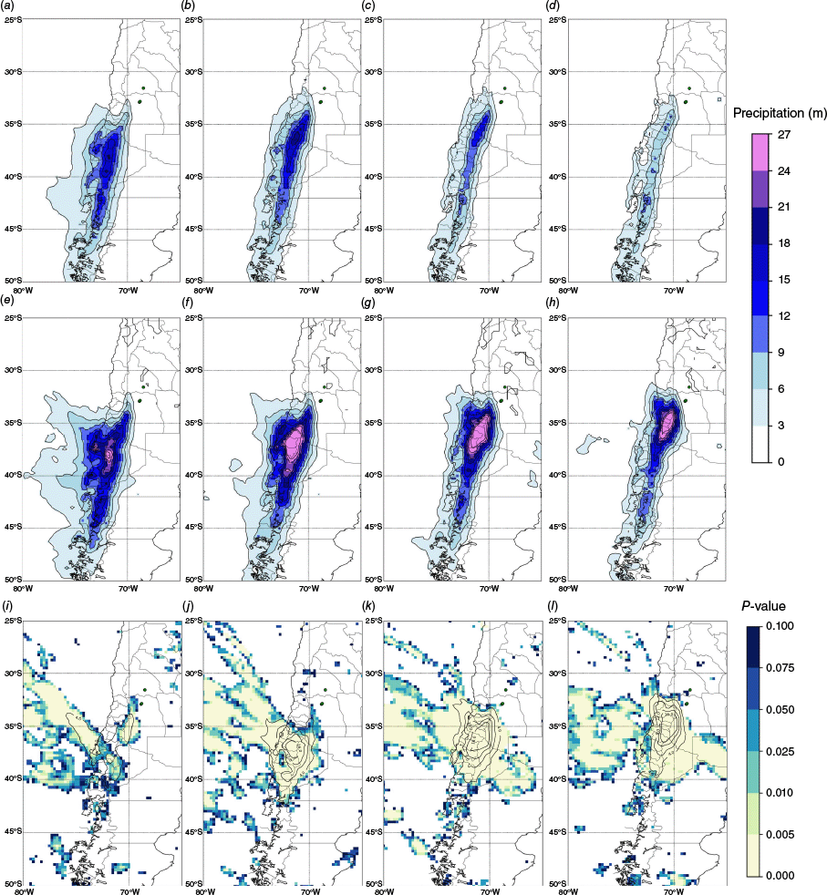
The difference in total precipitation is significant at 99.5% from −6 h from the event onset and afterward. In the previous 6 h, the differences in precipitation are away from the zone of interest, although a 4-m contour can be observed on the lee side south-west of the stations. In the event onset hour, total precipitation shows an increase in the precipitation differences according to the total precipitation patterns. This centre of major precipitation is located over the Chilean Andes and extends to the Argentinian plains (Patagonia) between 35 and 40°S. Six hours after the event onset, the difference is quite similar in intensity (compared with the previous hours) but significantly farther north-west. This centre is elongated NW–SE, coincident with the trough axis tilting seen lately in wind and geopotential patterns. Finally, 12 h after event onset, the precipitation difference centre expands to the east, approaching the stations.
The differences observed south-west of the stations are associated with the presence and progression of an intense cold front in S events. This front enhances precipitation on the windward side of the Andes owing to stronger orographic lifting. Considering the winter maximum frequency associated with S v. NS events, this pattern aligns closely with the findings of Garreaud (2009) for cold air intrusions over South America, highlighting the role of cold fronts in intensifying precipitation along the western slopes of the Andes and the subsequent reduction of precipitation on the eastern slopes due to subsidence. Similarly, in S events, the enhanced precipitation south-west of the stations reflects the stronger dynamics of S events, such as deeper troughs, robust low-level jets, stronger upper-level jets and slower frontal progression.
3.3. Vertical profiles
Given the lack of vertical soundings in Mendoza Airport, the ERA5 reanalysis data are used for this section. To assess if vertical profiles from ERA5 are comparable with the measured soundings, both in the mean profile and in Zonda event profiles, correlations between soundings and the reanalysis data (ERA5) are examined. Reference levels of 1000, 925, 850, 700, 500, 400, 300, 250, 200, 150, 100 and 50 hPa are taken from the Chilean side (Santo Domingo, −33.65°S, −71.61°W) and the same levels without 1000 hPa (which is usually underground) are taken for the Argentine side (Mendoza Airport). Soundings are launched at 0:00 and 12:00 hours UTC. Table 2 shows the mean correlation coefficients for each of the variables for the global mean profiles and for the Zonda cases. High correlation values are noted for the mean global soundings both at Mendoza and Santo Domingo for all variables. In the Zonda cases only, correlations close to one are observed for temperature and dew point temperature variables (both stations), as well as for zonal component and wind speed, but not for the meridional component of wind, which is analysed because of those low correlation values (Fig. 9).
| Variable | Santo Domingo (Zonda) | Santo Domingo (total) | Mendoza (Zonda) | Mendoza (total) | ||
|---|---|---|---|---|---|---|
| Temperature | R | 0.990 | 0.998 | 0.990 | 0.998 | |
| P value | 9.5 × 10⁻⁶ | 1.1 × 10⁻³ | 1.5 × 10⁻² | 1.1 × 10⁻³ | ||
| Dewpoint | R | 0.970 | 0.979 | 0.980 | 0.980 | |
| P value | 3.8 × 10⁻² | 2.8 × 10⁻³ | 1.7 × 10⁻² | 2.4 × 10⁻² | ||
| Zonal component | R | 0.960 | 0.970 | 0.930 | 0.960 | |
| P value | 1.7 × 10⁻² | 2.4 × 10⁻³ | 4.0 × 10⁻² | 3.0 × 10⁻³ | ||
| Meridional component | R | 0.830 | 0.870 | 0.700 | 0.840 | |
| P value | 5.5 × 10⁻² | 1.5 × 10⁻² | 1.3 × 10⁻¹ | 1.9 × 10⁻² | ||
| Wind speed | R | 0.950 | 0.958 | 0.920 | 0.958 | |
| P value | 1.9 × 10⁻² | 9.0 × 10⁻³ | 4.9 × 10⁻² | 9.0 × 10⁻³ |
Windward side Santo Domingo (−33.65°S, −71.61°W) and leeward side Mendoza Airport (−32.83°S, −68.78°W).
Vertical profiles of temperature and dewpoint, and the difference between the zonal and meridional components of the wind for severe and non-severe events. (a) Skew-T diagram; (b) U-wind, zonal component of the wind (m s−1) difference, and (c) V-wind, meridional component of the wind (m s−1) difference for Santo Domingo. (d) Skew-T diagram; (e) zonal component of the wind (m s−1) difference, and (f) meridional component of the wind (m s−1) difference for Mendoza. ERA5 profiles data are for the closest points to the locations. Clim (black contours) refers to climate vertical sounding.

Starting from this moment, the ERA5 data are taken for 0:00, 6:00, 12:00 and 18:00 hours UTC. In order to assess the mean vertical profiles of NS and S events, the closest hours to the event’s occurrence are considered (as for synoptic fields; see Section 2.1). Fig. 10 shows the vertical profiles for both sides of the Andes and the difference (S − NS) for the meridional and zonal components of wind. The windward side shows a mean vertical profile with an inversion at low levels, which is mainly associated with subsidence due to the presence of the Semipermanent Pacific Anticyclone. A considerably warmer profile than in Zonda cases is also noted, while the dewpoint profile does not present too many differences with the NS Zonda profiles. The zonal component of wind is stronger than the NS events across the profile, whereas its meridional component is much stronger at lower and mid-levels (negative values, north component) and less intense at higher elevations. This configuration reflects a less stable atmosphere with the presence of an intense upper-level jet streak. It also reflects more intense northerly humidity advection at low levels and less at higher levels, indicating that the trough axis is more tilted in S events.
Vertical cross-section at 33°S. Left panels for NS, middle panels for S Zonda events, and right panels for the differences. (a–c) Specific humidity (shaded, kg kg−1) and isentropes (contours, K). (d–f) vertical velocity (shaded, omega, Pa s−1) and isentropes (contours, K). (g–i) Squared Brunt–Väisälä frequency (shaded, s−2) and isentropes (contours, K). (j–l) meridional wind component (shaded, m s−1) and zonal wind in contours (m s−1).

The leeward side shows a mean vertical sounding with stronger differences with the Zonda profiles. A colder (than Zonda profiles) temperature is noted in the 900–600-hPa layer, but it is quite similar for mid- and upper levels. The dewpoint profile is much more humid than Zonda profiles from surface to mid-levels. S events have a warmer temperature profile than the NS ones in low and mid-levels and colder at upper levels, with peaks of heating at 850 hPa and cooling at 200 hPa. The tropopause shows higher temperatures for S events. The humidity profile shows a very dry layer difference between the surface and 500 hPa, and a more humid layer above it at upper levels. The zonal component of wind presents two positive maximums, one at low levels (700–800 hPa) and the other at upper levels (200 hPa, associated with the presence of a more zonal and intense upper-level jet streak as well as on the windward side). The meridional component of wind in S events is more intense and from the north at lower-levels, changing at 300 hPa and returning to being negative (north) at 100 hPa.
This is in agreement with the presence of intense Zonda wind at low to mid-levels (before it descends to the surface), which makes sense given that we took the hours leading up to the event onset, so it has not started yet. Taking into account the most frequent start times of these events (15:00–18:00 hours UTC in wintertime mostly; see Fig. 2 and 3), it is possible to think that there is a stronger stable layer of colder air close to the surface in S events in the morning. This layer does not allow the Zonda to descend to the surface, leaving its presence up at mid-levels.
Fig. 10 presents the vertical cross-sections for Zonda events at the latitude of 33°S, where Mendoza’s stations are located. The panels on the left illustrate NS Zonda events, those in the middle S events and those on the right depict the difference betwee them. The first analysis of the isentropes reveals that there is no presence of trapped lee waves in either S or NS events. S events show an intense descent, some of them reaching almost 200-hPa descent in the theta isolines after interacting with the orography. Major differences are noted on the leeward side, whereas on the windward side, there are almost no differences between S and NS events.
S Zonda events show a more humid and thick air mass near the surface on the windward side compared with NS events. This humid air is dynamically forced upward by the windward slope, contributing to increased precipitation on the mountains’ slope and crest. On the leeward side, S events are characterised by a drier air mass, which is mechanically and dynamically influenced by the presence of mountains. The difference in specific humidity is more pronounced on the windward side, where S events are wetter than NS events. On the lee side, differences are minor and show that S events are drier than NS, particularly on the lee slope and below it to the east, also promoted by the downward movement of the isentropes, which generates more drying.
The vertical velocity (omega) values indicate strong downward movements over the windward slope in both S and NS events. However, the maximum downward velocity is more intense in S events, reaching up to 6 Pa s−1 compared with 4 Pa s−1 in NS cases. This enhanced descent contributes to the more pronounced drying and heating of the air as it descends the leeward slope. The maximum difference is located where the maximum descent is located at mid-levels just above and over the slope.
This stronger downwind airflow for the S Zonda cases also leads to a relatively more stable layer at low levels, evidenced by higher values of the Brunt–Väisälä frequency. For both the S and NS Zonda, the most unstable layer is between 400 and 500 hPa, slightly lower downwind, separated by a more stable air column extending just above the mountain peaks linked to vertical mountain wave propagation. Although the leeward side for the S Zonda events shows increased instability in the layer at 500 hPa and significantly more stability at low levels just above the surface stations, the windward side shows relatively greater stability in the upper troposphere (above 300 hPa) for the NS cases.
In severe Zonda events, the north–south winds are stronger than in NS events. According to Norte (2015), the most common wind direction of Zonda wind is from the north-west, consistent with this finding. These northerly winds bring warm air to the lee side. This increases temperature and pressure differences across the Andes, making the system more baroclinic. As a result, the mid-level trough becomes deeper and tilts, strengthening the westerly winds, which help drive the Zonda. This stronger baroclinicity also increases rising air on the west side of the Andes and sinking air on the east side, favouring the Zonda wind. At the same time, the pressure difference across the mountains grows, pushing air over the Andes, creating stronger downslope winds. Although the north–south winds do not directly cause the Zonda, they help increase the pressure gradient and strengthen westerly winds, making severe events more intense.
The zonal component of wind on the lee side is notably stronger in severe events, with speeds of ~10 kt (~18.5 km h–1) at 850 hPa compared with 5 kt (~9.5 km h–1) in NS cases. This increase in wind speed over the lee slope is associated with more intense advection of potentially warmer and drier air from mid-levels (higher theta values), which contributes to the classic characteristic drying and warming of the foehn effect. The S events also display a more significant influence of the Andes and mountain waves activity, with noticeable mid-level drying and the intrusion of stratospheric air above the mountain tops. Major differences are near the tropopause, over the slopes and in upper levels where the maximum difference in V is located.
These vertical cross-sections reinforce the analysis conducted in this study by providing a detailed view of the areas driving the generation of S Zonda events. They emphasise the pronounced differences between S and NS events on the windward and leeward sides, particularly in the contrasting dynamics highly affected by the presence of the Andes. These distinctions underscore the critical role of vertical structure and atmospheric processes in shaping the unique characteristics of S Zonda events.
4.Discussion and limitations
Although this study advances knowledge of S Zonda wind dynamics, several challenges remain. The shortage of surface station data introduces several limitations, particularly given the Zonda’s spatial and temporal variability. High-resolution observational data sets and numerical modelling are needed to capture the mesoscale and local-scale variability of Zonda events. Future work could integrate satellite observations and more sophisticated modelling approaches to better resolve mountain wave processes and their impacts.
Although this work identifies similarities between S Zonda events and Alpine foehn winds, a global comparison and classification are needed. Further work could refine our classification within the global framework of foehn phenomena, but the Andes’ unique geography and the synoptic characteristics of Zonda winds suggest region-specific processes that require further investigation.
Most importantly, the accurate forecasting of Zonda events remains a significant challenge. Although recent advances, such as the use of ML techniques to identify synoptic fingerprints, have improved prediction capabilities, integrating these methods with real-time data and high-resolution numerical models is essential for operational forecasting. Enhanced forecasts could help mitigate the socioeconomic impacts of severe Zonda events, including risks to infrastructure, aviation safety, agriculture and wildfire management. Also, large-scale dynamic interactions, like the synoptic influence of El Niño–Southern Oscillation (ENSO) or Southern Annular Mode (SAM), could help with prediction of the Zonda wind at a larger time scale, similarly to what other researchers have presented in a climate change scenario (Mony et al. 2021).
5.Conclusions
This study provides a detailed analysis of the atmospheric dynamics and vertical structure of S Zonda wind events in Argentina, focusing on their synoptic-scale characteristics and differences from NS events. Previous studies, such as those by Seluchi et al. (2003a) and Norte et al. (2008) provided important case-based insights into severe Zonda events, whose synoptic features findings, like upper-level troughs, deep lee depressions and the North-west Argentine Low (NAL) were key factors and very similar, but there were some differences in their findings. Our study builds on these foundations by offering a more detailed and complete climatology of S and long-duration Zonda events, differentiating them from NS events, and exploring new dynamic variables in a statistically consistent framework. This approach fills a critical gap in the literature and extends the understanding of Zonda wind behaviour in the context of synoptic and orographic interactions.
The climatological study showed that S Zonda events are most frequent between August and October and exhibit earlier onset and later cessation than NS events, resulting in extended night-time and morning durations. The synoptic analysis showed that S downslope windstorms are driven by a combination of factors that differ from NS events. The system’s early development in S Zonda is located farther west than in NS events. For S Zondas, significant negative standardised anomalies of geopotential, larger at low levels than at mid-levels, revealed a low-pressure system structure more intense and baroclinic than in NS events. The geopotential at both pressure levels (500 and 850 hPa) shows exactly which areas experienced the greatest disparities between S and NS weather, facilitating tracking of the system’s progress and evolution. Similarly, the use of standardised anomalies helps identify locations or areas that need to be closely monitored and have the highest probability of producing a S Zonda event. A more than 3 σ standardised anomaly for the composite of S events indicates that individual events could exceed this value, suggesting that some could be very extreme phenomena.
A strong upper-level jet streak, with a significant and prolonged convergence–divergence pattern over the Andes, and an intensification of precipitation on the windward side of the Andes previous to the event onset, is a structure that resembles that of a strong cold front intrusion. The trough axis’ inclination in geostrophic balancing corresponds to a frontal trough acceleration. NS events tend to have a more barotropic structure and therefore the systems would tend to pass more slowly, but nevertheless present shorter durations than S events. This implies that the longer duration of extreme event occurrences results from their intensity rather than their speed. However, in the case of NS Zondas, the trough at low levels also accelerates at the end of the episode and moves more quickly after passing to the eastern side of the Cordillera, resulting in an early event ending.
When compared with previous works, S Zonda events share similarities with deep foehn winds observed in the Alps, particularly the moist foehn and dimmer foehn subtypes (Jansing et al. 2022). Like Alpine foehn, S Zonda events are driven by intense synoptic-scale forcing, including a quasi-stationary upstream trough, enhanced baroclinicity and strong jet streak dynamics. Windward-side precipitation and leeward-side warming observed in S Zonda events also align with the thermodynamic processes identified in studies of Alpine foehn (e.g. Seibert 1990; Elvidge and Renfrew 2016). However, the extended duration of these events and their unique response to the Andes’ geographic scale and orientation distinguish them from Alpine foehn dynamics, highlighting the regional specificity of Zonda windstorms.
In conclusion, the results emphasise the importance of understanding the synoptic atmospheric conditions, vertical structure and local topographic features in predicting and mitigating the impacts of severe Zonda winds. This paper not only enhances our understanding of these specific events but also offers broader implications for the study of severe downslope windstorms globally (like developing better forecasting tools, the interplay between synoptic-scale forcing, local topography and mesoscale dynamics, among others). A better understanding of this phenomenon is crucial for improving weather forecasting and developing mitigation strategies to minimise the socioeconomic impacts of these intense weather events.
Data availability
The ERA5 reanalysis data were downloaded from the Copernicus Climate Change Service (Hersbach et al. 2020). Data from weather station were provided by Servicio Meteorológico Nacional (see https://www.smn.gob.ar/).
References
Beusch L, Raveh-Rubin S, Sprenger M, Papritz L (2018) Dynamics of a Puelche foehn event in the Andes. Meteorologische Zeitschrift 27(1), 67-80.
| Crossref | Google Scholar |
Bougeault P, Binder P, Buzzi A, Dirks R, Houze R, Kuettner J, et al. (2001) The MAP special observing period. Bulletin of the American Meteorological Society 82(3), 433-462.
| Crossref | Google Scholar |
Burroughs LD (1987) Development of forecast guidance for Santa Ana conditions. National Weather Digest 12(2), 4-11.
| Google Scholar |
Drechsel S, Mayr GJ (2008) Objective forecasting of foehn winds for a subgrid-scale Alpine valley. Weather and Forecasting 23(2), 205-218.
| Crossref | Google Scholar |
Elvidge AD, Renfrew IA (2016) The causes of foehn warming in the lee of mountains. Bulletin of the American Meteorological Society 97(3), 455-466.
| Crossref | Google Scholar |
Elvidge AD, Renfrew IA, King JC, Orr A, Lachlan‐Cope TA (2016) Foehn warming distributions in non-linear and linear flow regimes: a focus on the Antarctic Peninsula. Quarterly Journal of the Royal Meteorological Society 142(695), 618-631.
| Crossref | Google Scholar |
Garreaud RD (2009) The Andes climate and weather. Advances in Geosciences 22, 3-11.
| Crossref | Google Scholar |
Glennf CL (1961) The Chinook. Weatherwise 14(5), 175-182.
| Crossref | Google Scholar |
Gohm A, Zängl G, Mayr GJ (2004) South foehn in the Wipp Valley on 24 October 1999 (MAP IOP 10): verification of high-resolution numerical simulations with observations. Monthly Weather Review 132(1), 78-102.
| Crossref | Google Scholar |
Graham RA, Grumm RH (2010a) Assessing the potential for rare precipitation events with standardized anomalies and ensemble guidance at the Hydrometeorological Prediction Center. Bulletin of the American Meteorological Society 90(4), 445-453.
| Crossref | Google Scholar |
Graham RA, Grumm RH (2010b) Utilizing normalized anomalies to assess synoptic-scale weather events in the western United States. Weather and Forecasting 25(2), 428-445.
| Crossref | Google Scholar |
Hann J (1866) Zur frage ueber den ursprung des foehn. Zeitschrift der österreichischen Gesellschaftfür Meteorologie 1(1), 257-263 [In German].
| Google Scholar |
Hart RE, Grumm RH (2001) Using normalized climatological anomalies to rank synoptic-scale events objectively. Monthly Weather Review 129(9), 2426-2442.
| Crossref | Google Scholar |
Hersbach H, Bell B, Berrisford P, Hirahara S, Horányi A, Muñoz‐Sabater J, et al. (2020) The ERA5 global reanalysis. Quarterly Journal of the Royal Meteorological Society 146(730), 1999-2049.
| Crossref | Google Scholar |
Hoinka KP (1985) What is a foehn clearance? Bulletin of the American Meteorological Society 66(9), 1123-1132.
| Crossref | Google Scholar |
Jansing L, Papritz L, Dürr B, Gerstgrasser D, Sprenger M (2022) Classification of Alpine south foehn based on 5 years of kilometre-scale analysis data. Weather and Climate Dynamics 3(3), 1113-1138.
| Crossref | Google Scholar |
Junker NW, Grumm RH, Hart R, Bosart LF, Bell KM, Pereira FJ (2008) Use of normalized anomaly fields to anticipate extreme rainfall in the mountains of northern California. Weather and Forecasting 23(3), 336-356.
| Crossref | Google Scholar |
Koyanagi T, Kusaka H (2020) A climatological study of the strongest local winds of Japan ‘Inami‐kaze’. International Journal of Climatology 40(2), 1007-1021.
| Crossref | Google Scholar |
Lentink HS (2012) Extreme foehn in Switzerland: a climatology and the relation to large scale flow. MSc (ClimPhys) thesis, Institute for Marine and Atmospheric research Utrecht (IMAU), Department of Physics and Astronomy, Faculty of Science, Utrecht University (UU), Utrecht, Netherlands. Available at https://studenttheses.uu.nl/handle/20.500.12932/15889
Lilly DK, Klemp JB (1979) The effect of terrain shape on non-linear hydrostatic mountain waves. Journal of Fluid Mechanics 95, 241-261.
| Crossref | Google Scholar |
Mayr G, Plavcan D, Armi L, et al. (2018) The community foehn classification experiment. Bulletin of the American Meteorological Society 99, 2229-2235.
| Crossref | Google Scholar |
McGowan HA, Sturman AP (1996) Regional and local scale characteristics of foehn wind events over the South Island of New Zealand. Meteorology and Atmospheric Physics 58(1), 151-164.
| Crossref | Google Scholar |
McGowan HA, Sturman AP, Kossmann M, Zawar-Reza P (2002) Observations of foehn onset in the Southern Alps, New Zealand. Meteorology and Atmospheric Physics 79, 215-230.
| Crossref | Google Scholar |
Miltenberger AK, Reynolds S, Sprenger M (2016) Revisiting the latent heating contribution to foehn warming: Lagrangian analysis of two foehn events over the Swiss Alps. Quarterly Journal of the Royal Meteorological Society 142(698), 2194-2204.
| Crossref | Google Scholar |
Montecinos A, Muñoz RC, Oviedo S, Martínez A, Villagrán V (2017) Climatological characterization of Puelche winds down the western slope of the extratropical Andes Mountains using the NCEP Climate Forecast System Reanalysis. Journal of Applied Meteorology and Climatology 56(3), 677-696.
| Crossref | Google Scholar |
Mony C, Jansing L, Sprenger M (2021) Evaluating foehn occurrence in a changing climate based on reanalysis and climate model data using machine learning. Weather and Forecasting 36(6), 2039-2055.
| Crossref | Google Scholar |
Muñoz RC, Armi L, Rutllant JA, Falvey M, Whiteman CD, Garreaud R, et al. (2020) Raco wind at the exit of the Maipo Canyon in Central Chile: climatology, special observations, and possible mechanisms. Journal of Applied Meteorology and Climatology 59(4), 725-749.
| Crossref | Google Scholar |
Nkemdirim LC (1986) Chinooks in southern Alberta: some distinguishing nocturnal features. Journal of Climatology 6(6), 593-603.
| Crossref | Google Scholar |
Norte FA (2015) Understanding and forecasting zonda wind (Andean Foehn) in Argentina: a review. Atmospheric and Climate Sciences 5(3), 163-169.
| Crossref | Google Scholar |
Norte FA, Ulke AG, Simonelli SC, Viale M (2008) The severe Zonda wind event of 11 July 2006 east of the Andes Cordillera (Argentine): a case study using the BRAMS model. Meteorology and Atmospheric Physics 102(1), 1-14.
| Crossref | Google Scholar |
Oard MJ (1993) A method for predicting Chinook winds east of the Montana Rockies. Weather and Forecasting 8(2), 166-180.
| Crossref | Google Scholar |
Otero F, Araneo D (2021) Zonda wind classification using machine learning algorithms. International Journal of Climatology 41, E342-E353.
| Crossref | Google Scholar |
Otero F, Araneo DC (2022) Forecasting Zonda wind occurrence with vertical sounding data. Advances in Atmospheric Sciences 39, 161-177.
| Crossref | Google Scholar |
Otero F, Araneo DC (2023) Synoptic fingerprints of Zonda wind from a statistical prediction model. International Journal of Climatology 43(15), 6946-6962.
| Crossref | Google Scholar |
Raphael MN (2003) The Santa Ana winds of california. Earth Interactions 7(8), 1-13.
| Crossref | Google Scholar |
Richner H, Hächler P (2013) Understanding and forecasting Alpine foehn. In ‘Mountain Weather Research and Forecasting: Recent Progress and Current Challenges’. (Eds F Chow, S De Wekker, B Snyder) pp. 219–260. (Springer Netherlands) 10.1007/978-94-007-4098-3_4
Seibert P (1990) South foehn studies since the ALPEX experiment. Meteorology and Atmospheric Physics 43(1), 91-103.
| Crossref | Google Scholar |
Seluchi ME, Norte FA, Satyamurty P, Chou SC (2003a) Analysis of three situations of the foehn effect over the Andes (Zonda wind) using the ETA–CPTEC regional model. Weather and Forecasting 18(3), 481-501.
| Crossref | Google Scholar |
Seluchi ME, Saulo AC, Nicolini M, Satyamurty P (2003b) The northwestern Argentinean low: a study of two typical events. Monthly Weather Review 131(10), 2361-2378.
| Crossref | Google Scholar |
Sharples JJ, Mills GA, McRae RH, Weber RO (2010) Foehn-like winds and elevated fire danger conditions in southeastern Australia. Journal of Applied Meteorology and Climatology 49(6), 1067-1095.
| Crossref | Google Scholar |
Stuart NA, Grumm RH (2006) Using wind anomalies to forecast East Coast winter storms. Weather and Forecasting 21(6), 952-968.
| Crossref | Google Scholar |
Viale M, Norte FA (2009) Strong cross-barrier flow under stable conditions producing intense winter orographic precipitation: a case study over the subtropical central Andes. Weather and Forecasting 24(4), 1009-1031.
| Crossref | Google Scholar |
Viale M, Nuñez MN (2011) Climatology of winter orographic precipitation over the subtropical central Andes and associated synoptic and regional characteristics. Journal of Hydrometeorology 12(3), 481-507.
| Crossref | Google Scholar |
Widmer R (1966) Statistische Untersuchungen über den Föhn im Reusstal und Versuch einer objektiven Föhnprognose für die Station Altdorf. Vierteljahrsschrift der Naturforschenden Gesellschaft in Zürich 111, 331-375 [In German].
| Google Scholar |
Würsch M, Sprenger M (2015) Swiss and Austrian foehn revisited: a Lagrangian-based analysis. Meteorologische Zeitschrift 24(3), 225-242.
| Crossref | Google Scholar |