
Synoptic mechanisms behind historical rainfall records in Australasia: Cyclone Jasper and Auckland low
Jeff Callaghan A *
A *
A
Abstract
Two recent events in far north-east Australia and Auckland, New Zealand, produced rainfall of a seemingly unprecedented nature, with the Australian event involving Tropical Cyclone Jasper and the New Zealand case involving a tropical low affecting Auckland. The aim of this paper is to identify mechanisms that produced the extreme rainfall. The analyses of the wind and thermal structure found that multiple factors occurring simultaneously were responsible for the extreme rainfall for both events. The problem is to deduce if this was result of climate change and global warming or long, expected intervals between such unique synoptic events arriving at a particular location on the globe. In the Jasper case, a search is conducted for similar extreme events dating back to the 19th Century and weather systems producing daily record rainfall. These record rainfall events are more common in the past two centuries than in recent decades over much of Australia. With the Auckland case, the extreme rainfall was unprecedented although four events on a larger scale involving tropical cyclones had huge impacts on New Zealand. Severe Tropical Cyclone Gabrielle occurred soon after the Auckland event, preceded by three others in 1988, 1968 and 1936. The structure of the Auckland low is shown to be unique when compared with Gabrielle. The latter was more intense and closer to Auckland than the former; however, it produced much less rain in the study area. These results will hopefully assist climate researchers in determining whether the events involving Jasper and the Auckland low were rare occurrences triggered by the simultaneous combination of several factors, or if they were influenced by the effects of a warming world.
Keywords: Auckland, Australia, atmospheric buoyancy, combination of factors, Cyclone Jasper, dew point dynamics, extreme rainfall, orographic effects, synoptic weather events, turning wind directions.
1Introduction
Extreme rainfall in Australasia is an increasingly relevant phenomenon, owing to both its impacts on society and its connection to global climate change (Sinclair 2002; Callaghan and Power 2014; Power and Callaghan 2016; Callaghan 2023). Catastrophic events in Australia and New Zealand such as those described in Callaghan (2021a, 2023) can have devastating consequences, such as massive flooding, infrastructure damage and significant economic losses, making the study of their causes and effects crucial. Given that Australia and New Zealand are particularly vulnerable to extreme weather events owing to their geographic location and exposure to tropical cyclones (TCs) and complex synoptic phenomena, the analysis of these events can provide valuable insights for disaster prediction and mitigation.
The importance of heavy rainfall over the eastern seaboard of Australia and New Zealand has been noted previously, e.g. Sinclair (1993), Hopkins and Holland (1997), Pepler and Rakich (2010), Pepler et al. (2013), Callaghan (2019a, 2021a) and Callaghan and Power (2014).
Extreme rainfall can be driven by a combination of climatic and synoptic factors, such as amount of moisture present and topography. The interaction between these factors plus wind structure can amplify the intensity of the phenomena, resulting in exceptional rainfall.
Numerous studies have documented the occurrence of extreme rainfall in the region, highlighting the temporal variability of these events and connections with broader climatic phenomena, such as El Niño or global climate change; see Speer (2008), Callaghan (2021b, 2023), Power and Callaghan (2015, 2016) and Callaghan and Power (2010).
Rainfall from Jasper was extreme and led to huge economic losses; the Insurance Council of Australia estimated that Jasper was responsible at A$1 billion and the Cairns City Council reported the destruction of 18 homes and severe damage to 168 others. The rain gauge at Bairds on the coastal plains north of Cairns (no elevation data available) recorded 2118 mm in 5 days and South Mossman (elevation 21 m) recorded 2088 mm in 5 days. The coastal station of Cape Tribulation (elevation 17 m) recorded its highest ever 24-h total (data since 1939) of 861.2 mm. The maximum 24-h total at Bairds was 870 mm; however, there are no available statistics for this site, which is primarily located for flood forecasting. The 861- and 870-mm reports are the third and fourth highest daily rainfall figure recorded anywhere in Australia.
Other stations also recorded their highest 24-h totals on record, with Mossman South (elevation 21 m) recording 714.0 mm, data available from 1908 illustrating how unique this event was for low-lying coastal stations, whereas the Auckland event was declared by New Zealand authorities as the highest daily rainfall there since European settlement. The New Zealand Insurance Council predicted that the event would result in the highest number of weather-related insurance claims on record, with insurance companies expecting that this will be the costliest weather event in New Zealand ever. Over 57,000 insurance claims were made in relation to the floods. The floods were its largest vehicle claims event in history, with an estimated 10,000 cars expected to be written off. The event also surpassed the total of NZ$351 million weather-related insurance claims in New Zealand during the entirety of 2022, which was previously the highest number in a year ever. Warming sea surface temperatures with rising sea levels are expected to continue thus enhancing floods and coastal sea damage into the future and well as rapid population growth in eastern Australia making the effects of a repeat of some past events unimaginable. Below, major flooding in past centuries in Australia is investigated, and in particular, the fastest growing area in population between Brisbane and the Victorian border where the greatest incidence of major flooding occurred during the 1890s, 1950s and 1970s (Callaghan 2023). As an example, population within this zone in the Gold Coast and Tweed region of northern NSW increased from 30,000 in 1954, when a TC had devastating impacts, to ~800,000 today.
The aim of this work is to conduct a study about the synoptic mechanisms that resulted in extreme rainfall during Cyclone Jasper and the Auckland low. Through this analysis, I intend to identify common patterns and factors that can enhance predictive capabilities and risk management for future events. In addition, this research will contribute to the advancement of predictive models and adaptation strategies for such events, providing essential data for disaster planning and management in Australasia in the context of a changing climate.
2Study areas
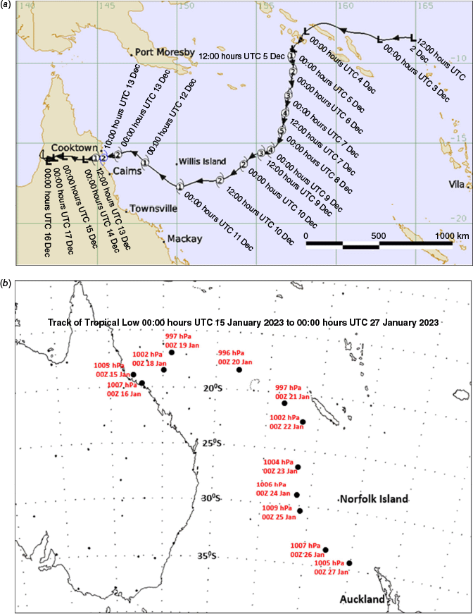
The study area is in the coastal region of north-eastern Australia and Auckland, New Zealand. The first study area is the coastal region affected by TC Jasper, located north of Cairns, Australia. The track of Jasper is shown in Fig. 1a, highlighting its slow movement after making landfall. The second study area is the city of Auckland, situated on the North Island of New Zealand. Auckland is a major metropolis with a temperate maritime climate. Fig. 1b shows the track of the tropical low that caused the extreme rainfall in Auckland. Coincidentally, this low initially formed near Cairns, Australia, and ironically, it did not develop into a particularly intense system.
(a) Track of Tropical Cyclone Jasper from 12:00 hours UTC (22:00 hours AEST) 2 December 2023 to 00:00 hours UTC 16 December 2023 (10:00 hours AEST). Image sourced from the Severe Weather section, Bureau of Meteorology, Brisbane. (b) Track of the tropical low with positions at 00:00 hours UTC from 15 January 2023 to 27 January 2023. Image created by the author.
3Data
The data used in this study were sourced from several organisations, each contributing critical information for analysing the relationship between atmospheric conditions and extreme weather events.
Bureau of Meteorology (Australia): data from the Bureau of Meteorology (see bom.gov.au) were obtained for analysing winds analyses (ACCESS, the Australian Community Climate and Earth-System Simulator) at different atmospheric levels, rainfall data and weather radar images.
Archived synoptic weather observations; these were obtained for Australian and New Zealand from the site (see www.meteomanz.com/?l=1).
National Institute of Water and Atmospheric Research (NIWA) (New Zealand): data from NIWA were crucial for hourly weather reports from Auckland airport, rainfall totals from various sites around the Auckland metropolitan area and radar data.
University of Wyoming: upper-level wind data from the University of Wyoming were essential for archived radiosonde observations came from the Auckland area (see https://weather.uwyo.edu/upperair/sounding.shtml).
Weathernerds: numerical wind analyses at upper atmospheric levels provided by Weathernerds (see https://weathernerds.org/) were used to provide the source of the events that had the wind structure to generate inner core convection on TCs. This wind structure – winds turning anticyclonic from 850 to 700 to 500 hPa – could be assessed by a series of 850-, 700- and 500-hPa wind charts and then highlighting the 700-hPa wind charts that fell into this category. An easier way was to overlay the 850-hPa winds on the 500-hPa winds. The advantage of the latter chart was it was much easier to determine whether the wind backed or veered. However, it slightly exaggerated the anticyclonic turning area of winds from 850 to 500 hPa as in a few cases there was no anticyclonic turning between the 700- and 500-hPa levels. In my previous papers, I have previously presented both methods but here I have used the charts showing the 850–500-hPa shear.
3.1 Methods
Winds turning anticyclonic or anticlockwise in the southern hemisphere (SH) were investigated from the 850-hPa level up to the 500-hPa level. This wind structure is associated with TC intensification in the tropics and extreme rainfall both in the tropics and in higher latitudes. For brevity, this wind structure is called warm air advection (WAA) owing to it having similar turning with height characteristics of quasi-geostrophic warm air advection. Examples of this wind structure causing extreme rainfall and being associated with TC intensification can be found in Tory (2014), Callaghan and Tory (2014), Callaghan and Power (2016) and Callaghan (2017a, 2017b, 2018, 2019a, 2019b, 2021a, 2021b 2022, 2023). Such WAA has a wind structure that produces streamwise vorticity (Davies-Jones 1984), encouraging rotating updrafts that separate updrafts from the destructive effects of downdrafts. Atmospheric buoyancy is important in producing extreme rainfall and it is generally associated with shallower WAA to 700 hPa in tropical air masses generating intense thunderstorms (Callaghan and Power 2016; Callaghan 2017b).
The common summer wind pattern off the north-east Australian coast is the opposite of the WAA pattern and it is referred to as cold air advection (CAA), and it is this wind structure that contributes to convective suppression. This is illustrated in fig. 2 of Callaghan (2021b), which shows the winds turning clockwise (cyclonic SH) with height over the area on average through January, February and March. The rainfall associated with this pattern is light rain, with the heavy rain located further north in the monsoon trough across the Gulf of Carpentaria and Cape York. Examination of an active La Niña 1973–1974 summer on Willis Island Meteorological station in the Coral Sea showed with monotonous regularity when south of the monsoon trough, the radar balloon flight showed a CAA structure with low-level south-east winds turning clockwise with height through southerly winds up to south-westerly at 500 hPa. During these episodes, only light rainfall was observed. It was only when a vortex developed, or an upper trough system extended into the tropics (see example Appendix 1; Callaghan 2021b) that a pattern conducive to heavy rainfall was observed. In those cases, because the most common 850–500-hPa vertical wind shear was westerly, a dipole structure was produced with WAA and ascent in the east and CAA and descent in the west.
In the Queensland Severe Weather Section of the Bureau of Meteorology, a diagnostic for WAA, heavy rain and TC intensification was developed using 850-, 700- and 500-hPa winds from the European Forecasting Model. This became possible from the 1990s when computer forecasting models became freely available. This clearly showed to us the relationship between WAA, heavy rain and TC intensification. This relationship was first posted in Callaghan and Tory (2014) and the paper used data from Holland (1984) to show that intensifying TCs in the Australian–south-west Pacific region had an asymmetric convective structure associated with WAA when considering the climatological winds at 850 and 500 hPa and moisture data.
The previous studies of Callaghan and Tory (2014), Tory (2014) and Callaghan and Power (2016) examined winds associated with extreme rainfall in both the tropics and the mid-latitudes of Australia. Further studies (Callaghan 2017a, 2019a) found this to apply in many cases around the globe. Theoretical argubments (Tory 2014) suggest, assuming gradient wind balance, that isentropic uplift is likely to be associated with winds that turn anticyclonically with height in most heavy rain-bearing systems, including the tropics and subtropics. Two Australian studies (Callaghan and Tory 2014; Callaghan and Power 2016) examined extreme rainfall and major flooding events in coastal catchments and more broadly over south-eastern Australia. Using radiosonde and reanalysis data, they examined the vertical structure of these systems in the period for which upper wind data became available and found WAA wind patterns were associated with extreme rainfall.
Table 1 illustrates, using a greater than 50-year climatology, how heavy rainfall results from low-level onshore winds that turn in an anticyclonic fashion (anticlockwise SH) up to 500 hPa. Table 1 was created by Samantha Taylor (Bureau of Meteorology, Brisbane, retired), and involved an extensive data search through the Bureau of Meteorology archives. Part of this search was to identify events where extreme rain was recorded without evidence of the deep layers of anticlockwise turning winds present. This occurred with thunderstorms developing in very humid tropical conditions without the anticyclonically turning winds or at least with a shallower layer of these turning winds. In Callaghan (2017b), it was shown how anticyclonic turning up to 700 hPa but a lack of deep anticyclonic turning between 700- and 500-hPa levels in humid unstable tropical conditions can be associated with extreme rainfall. The null events found are reported in Appendix 1 and it is noted that they were all associated with cold thermal troughs at the 700- or 500-hPa level extending from higher latitudes up to Cairns.
| Nil rainfall | Rainfall > 2 mm | Rainfall > 25 mm | Rainfall > 50 mm | Rainfall > 75 mm | Rainfall > 100 mm | ||
|---|---|---|---|---|---|---|---|
| 500-hPa wind (m s–1) | 267/06.0 | 277/03.5 | 360/01.5 | 035/02.0 | 028/03.0 | 044/03.5 | |
| 600-hPa wind (m s–1) | 248/04.0 | 252/01.0 | 075/02.0 | 071/03.0 | 064/03.5 | 071/04.0 | |
| 700-hPa wind (m s–1) | 200/03.5 | 123/03.0 | 094/05.0 | 090/05.5 | 087/06.0 | 091/07.0 | |
| 850-hPa wind (m s–1) | 128/05.0 | 119/08.0 | 109/07.5 | 107/08.0 | 104/08.5 | 105/09.0 | |
| 900-hPa wind (m s–1) | 128/05.0 | 127/08.0 | 116/08.0 | 116/08.0 | 112/09.0 | 112/09.5 | |
| 950-hPa wind (m s–1) | 143/04.0 | 144/06.5 | 139/06.0 | 135/06.5 | 132/06.5 | 132/07.0 | |
| 850–500-hPa wind shear (s−1) | 286/10.31 | 292/11.30 | 299/08.11 | 301/07.63 | 305/08.30 | 308/07.69 | |
| 700-hPa wind speed normal to shear (m s−1) | −3.49 | −0.55 | +2.12 | +2.75 | +3.69 | +4.21 |
4Results
4.1 Key mechanisms responsible for heavy rainfall associated with TC Jasper
Jasper was weakening by 12:00 hours UTC 9 December 2023 and Fig. 2 (top frames) shows how it had by then 200-hPa westerly winds over it. Below this level, easterly winds drove the system in the opposite direction towards the Queensland coast. Time series of the intensity of Jasper from both the automatic Digital Dvorak Technique from the University of Wisconsin Meteorological Satellite Studies on Tropical Cyclones, see http://wisc.edu) and the Cooperative Institute for Research in the Atmosphere (CIRA) at Colorado State University in Fort Collins, CO, 2024sh03_dgtldvor_202312090000.gif, 1124 × 766, see https://rammb-data.cira.colostate.edu/tc_realtime/products/storms/2024sh03/dgtldvor/2024sh03_dgtldvor_202312090000.gif) show Jasper reaching a peak intensity at c. 00:00 hours UTC 8 December 2023 and then rapidly weakening. CIRA also showed that the ocean heat content was still favourable for TC intensification up to 00:00 hours UTC 10 December 2023, so it was the 200-hPa winds impinging on Jasper that caused it to rapidly weaken.
The top frames show how Jasper around the time of peak intensity weakens as a 200-hPa trough systems moves over it bringing 200-hPa westerly winds over its circulation. Below these high levels were easterly winds and the system continued moving towards the Queensland coast. In the lower two frames are Cairns radar images for 04:59 hours UTC (left) and 13:59 hours UTC 13 December 2023 with surface average (10-min) wind, temperature and dewpoint (°C) and mean sea level pressure observations close to the radar time. Images sourced from the Australian Bureau of Meteorology.
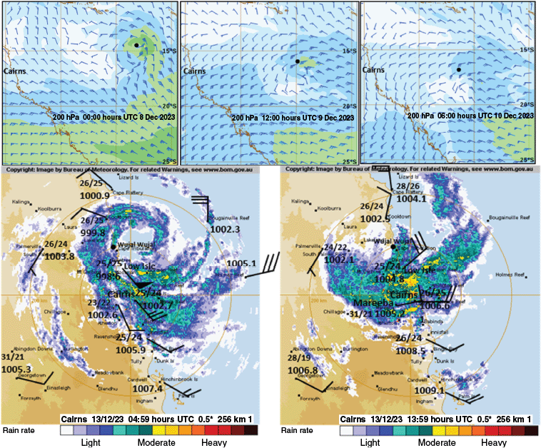
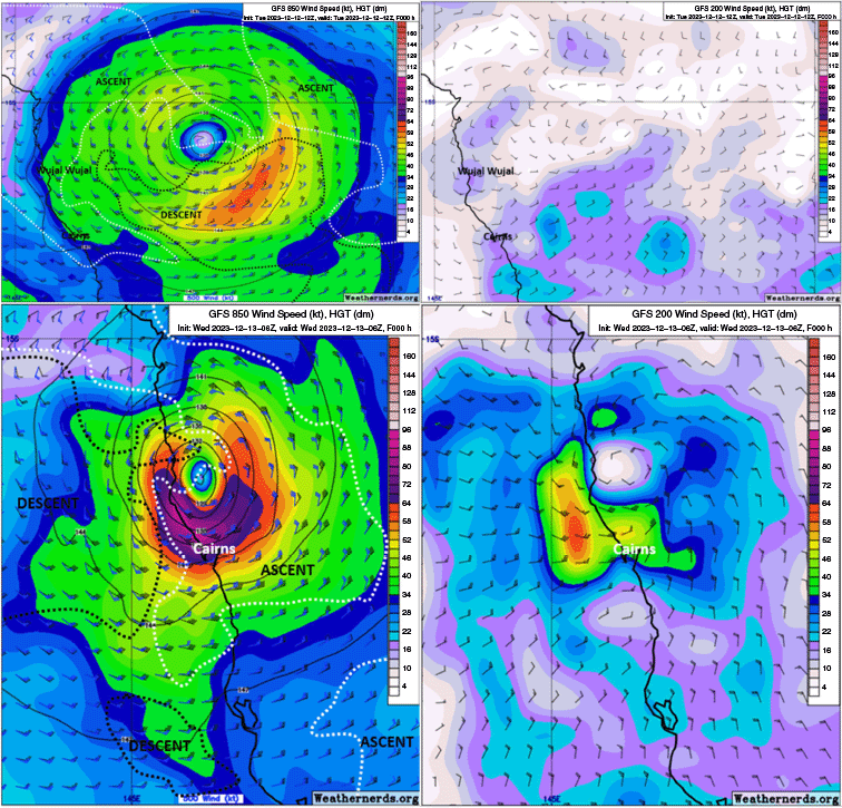
Jasper moved closer to the coast, increasing in intensity, with Low Isle reporting 50-knot (25.7 m s–1) mean 10-min average winds at 05:00 hours UTC 13 December (Fig. 2 lower left frame). The reported heaviest rainfall in the 24 h to 23:00 hours UTC 13 December 2023 was north of Cairns closer to the cyclone centre, with Yandill reporting 624 mm, Diwan near Daintree 507 mm and Black Mountain 476 mm. From Fig. 2 (lower right frame), this was the period when the heavy rain evident along the western eye wall of Jasper moved onto the coast. The high-resolution Global Forecast System (GFS) charts (Fig. 3) show the ascent region from anticyclonic (anticlockwise) turning in wind direction from 850 to 500 hPa wrapping around the western eye wall at landfall. Also noted is the increased cyclonic circulation at 200-hPa leading to increased warming at that level, which has been found to be associated with intensification of TCs (Rivoire et al. 2016).
The 850- and 500-hPa winds (left frames) with ascent diagnosed by anticyclonic (anticlockwise) turning in direction with increasing height and the descent regions by clockwise turning and 200-hPa winds (right frames) for 12:00 hours UTC 12 December 2023 (top) and 06:00 hours UTC 13 December 2003 (bottom). Images sourced from https://weathernerds.org/.
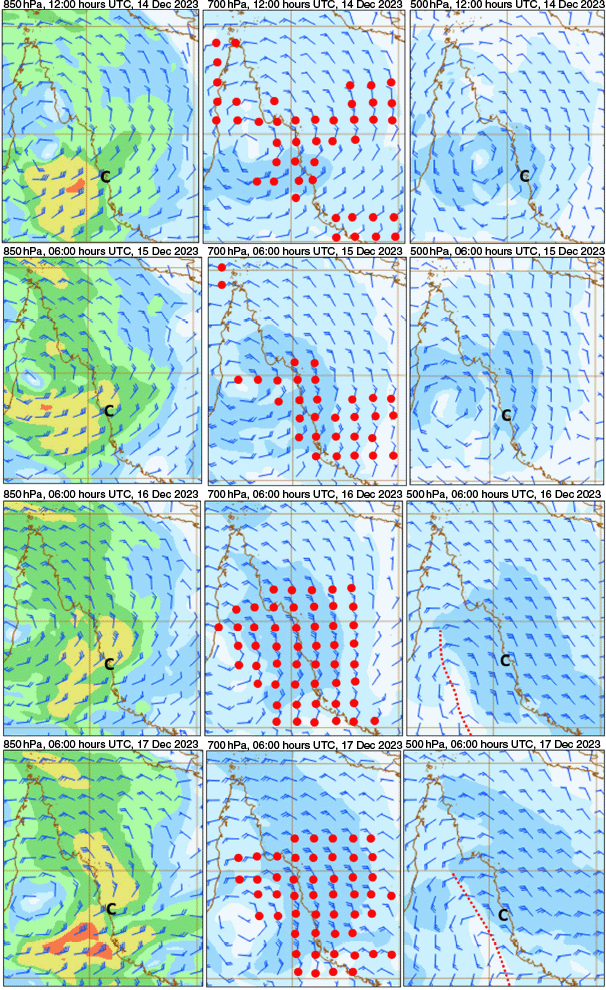
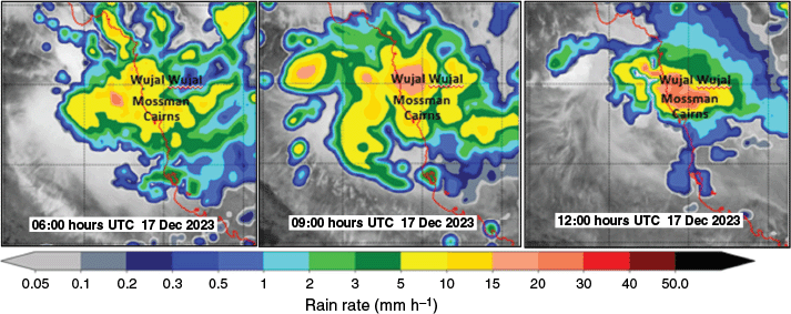
From Table 2, Jasper produced torrential rain throughout northern Queensland, with seven stations reporting 5- or 6-daily totals exceeding 2 m. Below, the wind structure producing this extreme rainfall and is diagnosed and an explanation for the record 24-h rainfall is given for the period to 23:00 hours UTC 17 December 2023. From Fig. 4, coastal dew points north from Cairns were high at ~24–25°C. From the ACCESS analyses from 12:00 hours UTC 14 December to 06:00 hours UTC 17 December 2023 (Fig. 5), note the ascent from anticyclonic turning winds 850 to 500 hPa along the coast north from Cairns. While coastal dewpoints north from Cairns were high at ~24–25°C, which indicated the tropical nature of the airstream being lifted (Fig. 6). From Table 2, the heaviest rain fell in the 24 h to 23:00 hours UTC 17 December 2023 (09:00 hours AEST 18 December 2023), and the microwave images (Fig. 7) show a heavy rain area developing between Cairns and Wujal Wujal by 12:00 UTC 17 December 2023. The actual 24-h period with the heaviest reported rain was at Myola (elevation 340 m) near Cairns with 915 mm in the 24 h to 14:00 hours UTC 17 December 2023 (00:00 hours AEST local time). This of course was outside the traditional registration time of 23:00 hours UTC (09:00 hours AEST local time) and cannot be compared historically. From fig. 9 in Callaghan and Power (2016), the 700-hPa northerlies along the coast north of Cairns in Fig. 5 (lower two frames) and Fig. 8 help explain why the coastal rainfall was as intense as at the elevated sites on the eastern Tablelands (see Table 2). That is, orographic lifting has less effect when the 700-hPa winds are parallel to the ranges rather than flowing up the escarpment.
| Station | 24-h rainfall (mm) | ||||||||
|---|---|---|---|---|---|---|---|---|---|
| Elevation | To 23Z 13 Dec 2023 | To 23Z 14 Dec 2023 | To 23Z 15 Dec 2023 | To 23Z 16 Dec 2023 | To 23Z 17 Dec 2023 | To 23Z 18 Dec 2023 | Total | ||
| China Camp near Wujal Wujal | Coastal but unknown | 246 | 284 | 221 | 226 | 599 | 20 | 1581 mm | |
| 5 days | |||||||||
| Yandill | Coastal but unknown | 624 | 178 | 231 | 199 | 701 | 79 | 2012 mm | |
| 6 days | |||||||||
| Bairds | Coastal but unknown | 471 | 192 | 259 | 326 | 870 | 103 | 2221 mm | |
| 6 days | |||||||||
| Diwan near Daintree | 36 m | 507 | 118 | 176 | 235 | 832 | 129 | 2097 mm | |
| 6 days | |||||||||
| Cape Tribulation | 17 m | 572 | 112 | 155 | 206 | 861 | 97 | 2004 mm | |
| 6 days | |||||||||
| Port Douglas | 8 m | 291 | 122 | 107 | 357 | 389 | 39 | 1305 mm | |
| 6 days | |||||||||
| Craiglie | Coastal but unknown | 286 | 121 | 88 | 430 | 390 | 14 | 1316 mm | |
| 5 days | |||||||||
| Mossman | 14 m | 434 | 148 | 156 | 386 | 621 | 163 | 1908 mm | |
| 6 days | |||||||||
| Mossman South | 21 m | 429 | 174 | 618 | 151 | 714 | Nil report | 2088 mm | |
| 5 days | |||||||||
| Whyanbeel Valley | 6 m | 462 | 203 | 208 | 361 | 700 | 142 | 2076 mm | |
| 6 days | |||||||||
| Black Mount | 465 m | 476 | 300 | 96 | 652 | 640 | 10 | 2164 mm | |
| 5 days | |||||||||
| White Cliff Point | 5 m | 341 | 223 | 98 | 512 | 420 | 4 | 1594 mm | |
| 5 days | |||||||||
| Bilwon | 375 m | 113 | 166 | 118 | 317 | 219 | 1 | 933 mm | |
| 5 days | |||||||||
| Bolton Road | 340 m | 248 | 172 | 125 | 348 | 275 | 1 | 1168 mm | |
| 5 days | |||||||||
| Mona Mona | 420 m | 365 | 281 | 189 | 434 | 365 | 0 | 1634 mm | |
| 5 days | |||||||||
| Myola near Kuranda | 340 m | 457 | 251 | 166 | 513 | 638 | 3 | 2025 mm | |
| 5 days | |||||||||
| Kuranda | 340 m | 450 | 229 | 125 | 510 | 517 | 9.5 | 1831 mm | |
| 5 days | |||||||||
| Copperlode Dam | 409 m | 326 | 241 | 81 | 345 | 302 | 2 | 1295 mm | |
| 5 days | |||||||||
| Kamerunga Bridge | 9 m | 269 | 115 | 55 | 398 | 371 | 2 | 1208 mm | |
| 5 days | |||||||||
Z refers to UTC.
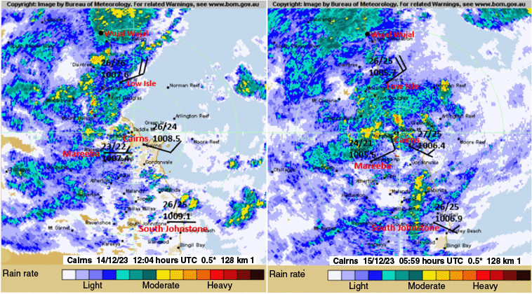
Cairns radar images for 12:04 hours UTC 14 December 2023 (left) and 05:59 hours UTC 15 December 2023 with surface average (10-min) wind, temperature and dewpoint (°C) observations close to the radar time. Images sourced from the Australian Bureau of Meteorology.
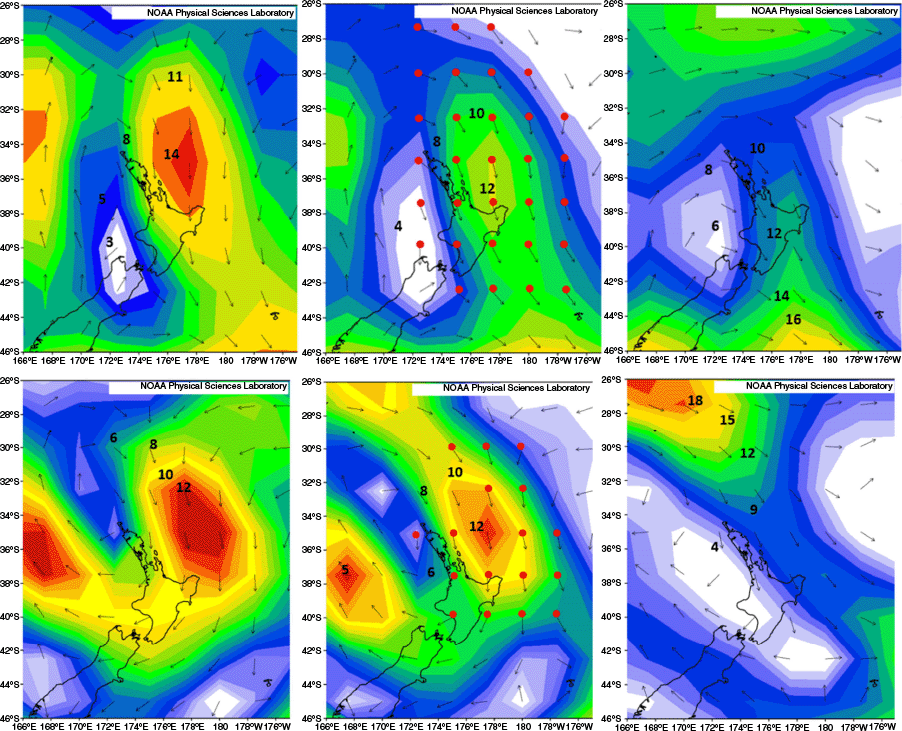
ACCESS winds at 850 hPa in the left frames, 700-hPa winds in the centre frames (with red circles highlighting where winds turned anticyclonic from 850 to 500 hPa), and 500-hPa winds in the right frames, where ‘C’ marks the location of Cairns. These are for 12:00 hours UTC 14 December 2023 in the top row, 06:00 hours UTC 15 December 2023 in the second top row, 06:00 hours UTC 16 December 2023 in the third row, and 06:00 hours UTC 17 December 2023 in the bottom row. Charts sourced from the Bureau of Meteorology, with annotations by the author.
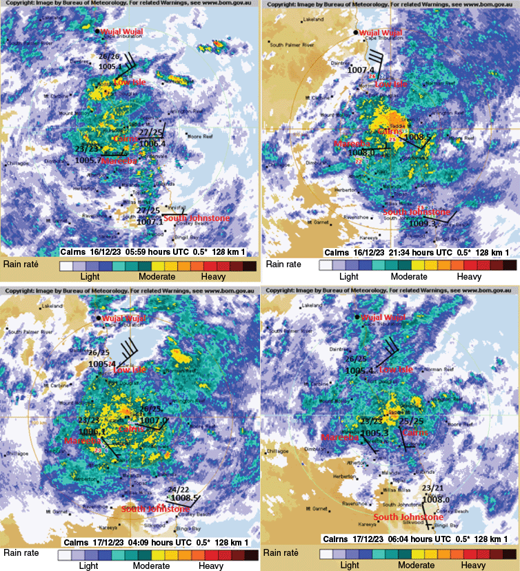
Cairns radar images with surface average (10-min) wind, temperature and dewpoint (°C) observations close to the radar time. These are for 05:59 hours UTC 16 December 2023 (top left) and 21:24 hours UTC 16 December 2023 (top right), and for 04:09 hours UTC 17 December 2023 (bottom left) and 06:04 hours UTC 17 December 2023 (bottom right). Images sourced from the Australian Bureau of Meteorology.
Naval Research Labotatory – Monterey Global Precipitation Measurement Imager rain images 06:00 hours UTC 17 December 2023 to 12:00 hours UTC 17 December 2023.
Reanalyses charts with mean flow over period 13–19 December 2023 for 850-hPa (top left), 700-hPa (top right), 500-hPa (bottom left) and 700-hPa mean temperature contours (K) for period 17–18 December 2023 (bottom right). NCEP, National Centers for Environmental Prediction; NCAR, National Center for Atmospheric Research. Images sourced from the NCEP NCAR Reanalysis (see https://psl.noaa.gov/data/composites/hour/).
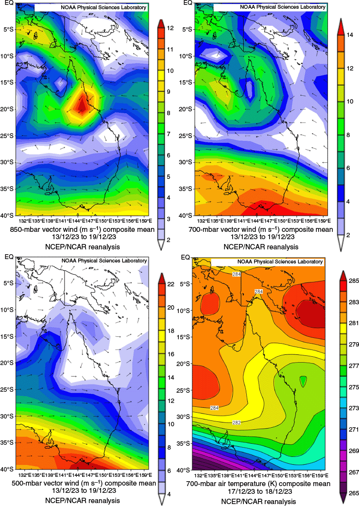
The mean flow over the heavy rain period from reanalyses charts (Fig. 8) shows a ridge (between easterly and westerly flow) near 25°S latitude at 850 and 700 hPa and at these levels, the easterlies in the circulation of Jasper are stronger than the monsoon westerlies. Therefore, at these lower levels, this would tend to move Jasper westward. However, at 500 hPa, there is no sub-tropical ridge and westerly flow dominates, and this would tend to move the storm eastwards. This gave the centre of Jasper over the period a slope eastward with an 850-hPa centre just over the Gulf of Carpentaria tilting to a 500-hPa centre over Cape York Peninsula. A result of this tilt was a westerly 850–500-hPa shear with WAA at 700 hPa east of the centre and CAA west of the centre. This concentrated the heavy rain near and north of Cairns (green area in Fig. 8, top right frame, east of the centre). The mean winds show a WAA structure around Cairns with north-easterlies at 850 hPa turning anticlockwise through northerlies at 700 hPa to north-westerlies at ~500 hPa. In Fig. 8 (lower right frame), a cold 700-hPa trough can be seen extending up towards the rain area over 17 and 18 December 2023 (the period of heaviest rainfall). As shown in Appendix 1, these cold features enhanced the Cairns rainfall by increasing the instability of the high-moisture onshore flow. Therefore, an explanation of the record rainfall north from Cairns is that the high-moisture onshore flow was being lifted by the turning wind structure and by 17 December 2023, this was occurring in an atmosphere that became very unstable owing to cool middle-level air extending up to north Queensland.
During the record rain at Bellenden Ker mentioned above, nearby Cairns upper winds had a strong easterly wind component at 700 hPa that was turning anticlockwise with height from the 850- to 500-hPa level. Compare this wind structure with the winds in the lower two frames of Fig. 5 where northerly 700-hPa winds (also turning anticlockwise with height) delivered extreme rainfall to the low-lying coastal stations.
4.2 Driving forces behind the rainfall associated with the Auckland Low
According to NIWA, Auckland airport received more than its average monthly rainfall for January (201 mm or 7.9″) within 1 day on 27 January 2023. By 22:00 hours (19:00 hours UTC) on 27 January, other locations in Auckland had reported record daily rainfalls before the day was over; the Museum of Transport and Technology (MOTAT) had 238.4 mm (9.39″), Albany had 260.6 mm (10.26″) and highest daily rainfall occurred in Mangere (Auckland Airport), with a total of 265 mm (10.4″). The three automatic weather stations covered the whole Auckland urban area from MOTAT in the north and Albany in central areas to the airport in the south. 27 January 2023 was declared the wettest day at Auckland airport on record, exceeding the previous record of 161.8 mm (6.37″).
The flooding in Auckland on 27 January affected 25 suburbs in the city, closed major motorways and left 6000–8000 homes in need of damage assessment. NIWA reported that emergency services in Auckland responded to 719 weather incidents, answered 2242 emergency calls and made 126 rescues on Friday and Saturday morning. A total of 811 water-damaged cars had to be manually removed from roads, and 20 water damaged buses were removed from service.
The New Zealand Insurance Council predicted that the event would result in the highest number of weather-related insurance claims on record, with insurance companies expecting that this will be the costliest weather event in New Zealand ever. Over 57,000 insurance claims were made in relation to the floods. The floods were its largest vehicle claims event in history, with an estimated 10,000 cars expected to be written off. The event also surpassed the total cost of NZ$351 million of weather-related insurance claims in New Zealand during the entirety of 2022, which was previously the highest number in a year ever.
New Zealand authorities say four people died during the record rainfall. On Friday 27 January in the evening, more than 150 mm of rain fell in just 3 h around the city, and at Auckland airport in Mangere, 71 mm was dumped in the space of 1 h. The rain closed highways and poured into homes. Auckland, New Zealand’s largest city of 1.6 million people, remained in a state of emergency. The tropical low responsible for the rain developed near Townsville in north-east Australia and travelled in a large arc across the Coral and Tasman Seas to New Zealand (Fig. 1b). Wind analyses from the 850–500-hPa levels during the heavy rain (Fig. 9) show the strong lift the flow was experiencing as it moved down into Auckland and the North Island of New Zealand. Additionally, the radiosonde data received from the soundings at Whenuapai Airforce base in the northern suburbs of Auckland showed the strong ascent from anticlockwise turning winds with height and atmospheric instability associated with the flow into Auckland.
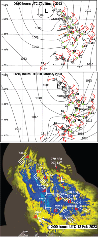
US reanalyses winds 850 hPa (left), 700 hPa (centre) (with red circles highlighting where winds turned anticyclonic from 850 to 500 hPa) and 500 hPa (right frames) with contours labelled in metres per second. These are for 06:00 hours UTC 27 January 2023 in the top row and 06:00 hours UTC 28 January 2023 in the bottom row. Images sourced from the NCEP NCAR Reanalysis (see https://psl.noaa.gov/data/composites/hour/).
Whenuapai winds and temperatures at 21:00 hours UTC on 26 January 2023 were 850-hPa temperature 12.4°C, dew point 12.4°C and wind 020/22.65 m s−1; 700-hPa temperature 3.60°C, dew point 2.8°C and wind 005/15.96 m s−1; 511-hPa wind 360/8.75 m s−1; 500-hPa temperature −11.90°C, dew point −12.10°C and wind 005/8.75 m s−1.
Total Totals 48.6 and lifted index −1.22 were indicative of strong instability conducive to forming significant thunderstorms.
Whenuapai winds and temperatures at 09:00 hours UTC on 27 January 2023 were 850-hPa temperature 14.20°C, dew point 11.50°C and wind 015/14.41 m s−1; 700-hPa temperature 3.80°C, dew point −1.10°C and wind 340/11.33 m s−1; 500-hPa temperature −11.30°C, dew point −12.90°C and wind 330/9.27 m s−1.
Total Totals 48.3 and lifted index −1.77 indicative of strong instability conducive to forming significant thunderstorms.
The winds show the anticyclonic turning of the winds from 850 to 511 hPa at 21:00 hours UTC 26 January 2023 and from 850 to 500 hPa at 09:00 hours UTC 27 January 2023. The Total Totals values of 48 or more (an indicator of warm moist low levels overlain by cool mid-levels of the atmosphere) indicated strong instability or buoyancy while the negative lifted index showed that the atmosphere over Auckland was easily lifted.
Thus, like the atmosphere over Cairns with Jasper, the onshore flow was subjected to large-scale ascent while the air parcels within this flow were buoyant and easily lifted.
From the reanalyses winds in Fig. 9, Auckland is well embedded in the ascent region at 06:00 hours UTC 27 January 2023 but on the western fringe by 06:00 hours UTC 28 January 2023 when the onshore ascent flow is focussed further east. At 06:00 hours UTC 27 January 2023 (Fig. 10 top frame), note the strong north-east flow onto Northland with high dew points (19–20°C) and an opposing west-north-westerly wind at Auckland forming strong localised convergence in Auckland. This convergence zone is examined more closely from the hourly observations at Auckland airport below during 27 January 2023. At 04:00 hours UTC, Auckland reported light rain with strong east-north-east winds. The rainfall rate then became strong as these winds weakened and became more variable, opposing the strong east-north-east winds. These east-north-east winds picked up again at Auckland airport and the rainfall rate became light.
Mean sea level pressure analyses for 06:00 hours UTC 27 January 2023 (top) and 06:00 hours UTC 28 January 2023 (middle) showing mean winds (10-min) plots (normal plotting convention), isobars (hPa), dewpoints (°C) and green circles indicating rain at analysis time at the station. The bottom frame shows the radar image of disastrous Tropical Cyclone Gabrielle passing close to Auckland at 12:00 hours 13 February 2023 with mean winds, dewpoints (in red) and mean sea level pressures displayed. Auckland reported 61.6 mm in the 24 h to 00:00 hours UTC 14 February 2023. Top two images created by the author, bottom image sourced from the National Institute of Water and Atmospheric Research, New Zealand, with wind plots added by the author.
Station: Auckland Aero Automatic Weather Station (AWS) (elevation 7 m, 37°00′S 174°48′E):
27:04 hours UTC; 060/22 knots; temperature 19.3°C; dew point 19.3°C; light rain;
27:05 hours UTC; 100/05 knots; temperature 19.2°C; dew point 19.2°C; 45 mm, past 6 h heavy rain;
27:06 hours UTC; 280/10 knots; temperature 184°C; dew point 18.4°C; 65 mm, past 6 h heavy rain;
27:07 hours UTC; 030/11 knots; temperature 19.2°C; dew point 19.2°C; heavy rain, 71 mm in 1 h;
27:08 hours UTC; 220/05 knots; temperature 17.3°C; dew point 17.3°C; heavy rain;
27:09 hours UTC; 070/07 knots; temperature 18.7°C; dew point 18.7°C; light rain;
27:10 hours UTC; 040/14 knots; temperature 20.0°C; dew point 19.5°C; light rain;
27:11 hours UTC; 060/22 knots; temperature 20.0°C; dew point 20.0°C; light rain, 175 mm past 6 h.
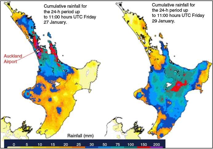
By 06:00 hours UTC 28 January 2023 (Fig. 10 middle frame), this north-east onshore flow had weakened, and the rain was easing. This is shown in Fig. 11 displaying 24-h rainfall to 12:00 hours UTC 27 January 2023 in the Auckland and adjacent region; the next day (24-h rainfall to 12:00 hours UTC 28 January 2023), the heavy rain had slipped south-east and led to the devastating floods in Hawkes Bay from TC Gabrielle. Fig. 10 (lower frame) shows the disastrous TC Gabrielle passing close to Auckland but producing only moderate rainfall in the 24 h near Auckland. Note the lower dew points compared with the top two frames in Fig. 10 and the lack of direct onshore flow into the Auckland area. TC Gabrielle went on to claim 11 lives in the Hawkes Bay floods following on from similar devastation from TCs striking New Zealand from the north.
4.3 Analysis of climate drivers
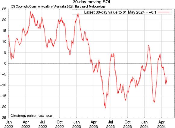
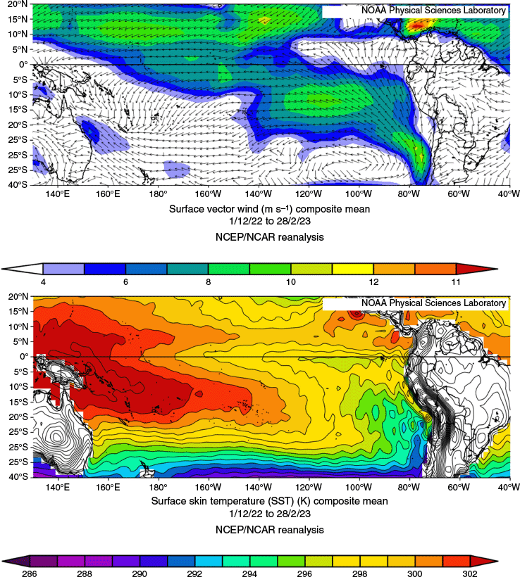
The Southern Oscillation Index, or SOI, gives an indication of the development and intensity of El Niño or La Niña events in the Pacific Ocean. The SOI is calculated using the pressure differences between Tahiti and Darwin and is positive for La Niña events and negative during El Niño events (McBride and Nicholls 1983). From Tozer et al. (2023), one should expect dry conditions in El Niño and wet in La Niña for eastern Australia. The region associated with Jasper was under the influence of a weakening El Niño, the SOI showing a weakening trend with −13.6 in September 2023, −6.8 in October 2023, −8.6 in November 2023 and −2.4 in December 2023. Another driver, The Madden–Julian Oscillation (MJO), was not expected to have much influence in this case as at the time, it was over the Indian Ocean and was moving from there over to the maritime continent. Appendix 1 shows the equatorial surface winds and temperature means leading into the Jasper event, comparing it with both major El Niño and La Niña events. From these analyses, the Jasper extreme rainfall event was not under the influence of a typical El Niño event. The Southern Annular Mode (SAM) was positive, having more an effect of increased rain in south-east Australia. The Indian Ocean Dipole (IOD) was positive, having no effect on rain from Jasper.
According to NIWA, Auckland would expect more rainfall in summer under La Niña conditions. The Auckland event occurred during the tail end of a prolonged La Niña event, with the SOI figures for December 2022 being +20.0, January 2023 +11.8 and February 2023 +10.5. For Auckland, the MJO was weak, being in the central to eastern Pacific. The SAM index only briefly dipped to negative levels. The IOD was neutral, making the La Niña event the main influence for Auckland’s rain. See Appendix 1 Fig. A1 for a time series of the 30-day moving SOI for January 2022 to April 2024.
5Discussion
The area of rainfall associated with Jasper can be seen to be the highest on record in Fig. A5 in Appendix 1. The two storms with historical record rainfall rates had three things in common: they had, from the dew point analyses, abundant available moisture in the air masses moving over the coast; a mechanism from the wind structure that turned anticlockwise (anticyclonic SH) with height from onshore at 850-hPa winds up to the 500-hPa level, and evidence of low static stability to produce buoyancy in the airmass enabling embedded convection to form in the general heavy rainfall. In Auckland, the colliding low-level wind currents across the city during the heaviest rainfall provided convergence to thunderstorm development. The factors that made Jasper unique were its near-stationary movement and the extreme rainfall in coastal stations related to winds at 700 hPa flowing parallel to the mountains.
5.1 Earlier disastrous rainfall events in Australia as a comparison with TC Jasper
On the escarpment south of Cairns, Bellenden Ker Top station of Cairns (elevation 1555 m) recorded 1947 mm in the 48-h period ending 23:00 hours UTC 4 January 1979 and a 5-day total of 2457 mm to that date. Violent winds at times prevented the rain gauges being analysed every 24 h. The bottom station at Bellenden Ker (elevation 97 m) recorded 1907 mm in the 4 days to 4 January 1979, indicating the effect of orographic lifting in this case. The Australian official 24-h record of 907 mm was recorded at Crohamhurst, latitude 26.81°S, elevation 200 m, in south-east Queensland on 3 February 1893. The Crohamhurst 4-day reading was 1964 mm. These Crohamhurst data were associated with the largest ever Brisbane City flood, and 14 days later, another event of almost identical magnitude struck the city (Callaghan and Power 2014).
In Australia’s largest city, the greatest recorded floods were in the 19th Century (Callaghan and Power 2014). The largest flood in Sydney in the Hawkesbury and Nepean Rivers system was in 1867 (41 fatalities) when a low remained slow-moving over the Blue Mountains for 3 days whereas the largest Georges River floods in Sydney (the catchment with Australia’s densest population) also occurred in the 19th Century (Callaghan and Power 2014). Other 24-h rainfall records in NSW are: Newcastle Nobbys Pilot, 283.7 mm 19 March 1871; Maitland West, 375.4 mm 9 March 1893; Bulahdelah, 502.9 mm 16 April 1927; Coffs Harbour, 404.6 mm 28 April 1963, and Kempsey, 314.5 mm 28 April 1963.
In south-east Queensland, record 24-h rainfall was recorded at Brisbane, 464 mm 1 January 1887; Nerang, 401.3 mm 6 February 1931, and Southport, 426.2 mm 6 February 1931. In Victoria, the largest Yarra River and largest Gippsland floods occurred in 1934 (Callaghan 2021c), claiming 37 lives, 17 from freshwater flooding and 20 at sea. The worst floods and record rainfall occurred on the west coast of Victoria during February 1946 when there were seven drowning fatalities; as an example, Port Fairy recorded 189.7 mm in 24 h. From Callaghan (2020a), the largest Murray River flood occurred in 1870. The worst Tasmanian floods occurred in north-east Tasmania in April 1929, when 22 people died and 5000 were made homeless. There were 2000 buildings damaged and 100 destroyed, and 25 bridges were destroyed. The Hobart City record 24-h rainfall of 156.2 mm occurred on 15 September 1957. Adelaide’s record 24-h rainfall occurred on 7 February 1925, with 141.5 mm at West Terrace and 163.6 mm at North Adelaide. In Perth, the record 24-h rainfall was recorded on 9 February 1992 with 120.6 mm in the city and 132.0 mm at the airport.
As an example of extreme rainfall inland penetration, one of Australia’s worst flooding disasters occurred when a TC brought extreme rainfall into the dry interior of tropical Queensland. At 23:00 hours UTC 25 December 1916, a severe TC passed over the Dent Island lighthouse just north of Mackay, where a central pressure of 958 hPa was recorded. By 11:00 hours UTC 27 December, the night of commencement of the flood, it was located ~90 km north of Clermont. Disastrous flooding occurred and the final death toll in Clermont was somewhere between 61 and 70. The lower part of the town was never rebuilt, and settlement shifted to higher ground. Most of this rain fell over the 15-h period from 08:00 hours UTC to 23:00 hours UTC 27 December 1916 (Callaghan 2021b). The heaviest rainfall was in a zone 30–60 km east of the track of the cyclone, with totals to 597 mm. These rainfall totals are staggering for an inland location when you consider the record daily rainfall for Tully, one of the wettest locations in Australia, is 606 mm, less than the rainfall rate of 597 m in ~15 h. Obviously, the TC kept its inner core structure intact as it made its way towards Clermont and this is a sobering message for the inundation potential when a unique set of circumstances simultaneously occur. An example during 2008 provided evidence how the Clermont disaster may have occurred. From Callaghan (2021b), a tropical low formed into a cyclone tracking overland between Townsville and inland regions while under the influence of a wind structure described above as WAA, and went on to produce rainfall while still under the influence of this wind structure in the Central Highlands (where Clermont is located) with an annual recurrence interval of 2000 years or 0.05% annual exceedance probability.
5.2 Coral Sea TCs affecting New Zealand
New Zealand suffers disastrous effects from TCs moving onto the islands from the Coral Sea. As referred to above, TC Gabrielle followed soon after the 2023 Auckland low with floods devastating the Hawkes Bay region, resulting in 11 fatalities. Other examples from Callaghan (2021a) include TC Bola, which created some of the heaviest rainfall totals for a single storm in the history of New Zealand; one station recorded 419 mm (16.5″) in a 24-h period (Sinclair 1993) and three people perished. TC Giselle in April 1968 claimed 26 lives, including 51 from the sinking of the inter-island ferry Wahine. From another NIWA report in 1936, a TC formed south of the Solomon Islands on 28 January 1936. On 1 February, the cyclone was centred near Norfolk Island. It then interacted with a cold front like Giselle, which caused it to intensify prior to hitting the North Island of New Zealand on 1 February. During the night, it increased in speed and intensity, with the centre passing over Auckland. By 09:00 hours NZ time on 2 February 1936 it was located near Kawhia (55 km south-west of Hamilton); 12 people died and it brought high winds, heavy rain, flooding and rough seas to the whole North Island and Marlborough, which caused widespread damage. Damage in 2008 New Zealand dollars was reported as being over NZ$1 billion.
5.3 Anthropogenic effects and global warming
Warming sea surface temperatures with rising sea levels are expected to continue thus enhancing floods and coastal sea damage into the future (Fox-Kemper et al. 2021). In coastal areas between Brisbane and the Victorian border, the largest incidence of major flooding occurred during the 1890s and the 1950s (Callaghan 2023), indicating periods of unique events over those decades. If these occurrences continue, we can expect catastrophic events to occur. This will be exacerbated owing to this area having the fastest growing population in Australia. For example, the 1954 cyclone (Callaghan 2023) caused 36 fatalities in southern Queensland and north-eastern New South Wales and produced rainfall records still standing in those locations today. A 24-h rainfall registration of 900.4 mm broke all-time records at Springbrook Forestry (elevation 806 m), falling in the 24 h to 12:45 hours UTC 20 February 1954, and 250 mm fell between 07:00 and 11:30 hours UTC, which was the most intense period (Brunt 1956). Not long after, the current NSW 24-h record was set during this cyclone at Myrtle St Dorrigo (elevation 740 m) of 809.2 mm to 23:00 hours UTC 20 February 1954. The track through NSW is shown in fig. 19 of Callaghan (2023) with the sea surface temperatures (SSTs) in fig. 20. From this, it was shown that SSTs in 1954 were warmer than those in February 2022 (Callaghan 2023). There is no reason to suspect the 1954 SST figures as the area is part a busy shipping lane between Australia and Asia. The SSTs were a factor in making this event unique and show that marine heat waves occurred in the past. The Gold Coast–Tweed region then had a population of ~30,000, whereas today it is ~800,000 or more, so the impact from such a storm would be unthinkable. Quickly following this event were the NSW floods of 1955 (Bond and Wiesnern 1955), with 25 fatalities and enormous stock losses. Then, the largest Murray Darling floods since 1870 occurred during 1956 (Callaghan 2020a).
Rapidly increasing population and increased urbanisation significantly affect rainfall runoff, leading to a larger volume of runoff and a decrease in infiltration. This occurs because urbanisation replaces natural, permeable surfaces like soil and vegetation with impervious surfaces like roads, buildings and parking lots. As a result, rainwater flows more rapidly across these surfaces and into drainage systems rather than being absorbed into the ground (Bárdossy and Anwar 2023).
6Conclusion
TC Jasper in Australia and the tropical low in Auckland, New Zealand, produced exceptional rainfall.
The analysis of wind structure and temperature patterns revealed that several synergistic factors contributed to the intensity of precipitation in both cases. In the case of Jasper, similar extreme events were more frequent in the 19th and early 20th Centuries than in recent decades, suggesting that such phenomena, although not unprecedented, may occur at long intervals and under specific climatic conditions.
Although it cannot be conclusively stated that the Jasper and Auckland events are solely driven by climate change, the research suggests that global warming may have amplified these phenomena. Cyclone Gabrielle, which occurred after the Auckland event, was more intense and closer to the region but produced less precipitation. This contrast highlights the complex interplay of climatic factors – such as sea surface temperatures and atmospheric conditions – that can influence the variability and severity of extreme events.
El Niño events have a profound impact on Australia’s climate, as evidenced by the period between 1820 and 1860, when extreme conditions linked to a strong El Niño were observed. In a warming world, prolonged El Niño events could exacerbate challenges such as droughts, water shortages, wildfires and crop failures. The historical case of 1846 (see below), when strong winds from an El Niño event caused a ship to be driven onto the coast, serves as an example of how these climatic events can disrupt environmental conditions significantly.
The occurrence of these extreme events underscores the need for more comprehensive studies into the interactions between climate systems and the future climate trends.
It is recommended to conduct more studies to understand how current and future climatic conditions may affect the occurrence and intensity of similar phenomena. The area of rainfall associated with Jasper can be seen to be the highest on record in Fig. A5, Appendix 1. The two storms with historical record rainfall rates had three things in common in that they had, from the dew point analyses, abundant available moisture in the air masses moving over the coast; a lifting mechanism from the wind structure that turned anticlockwise (anticyclonic SH) with height from onshore at 850-hPa winds up to the 500-hPa level, and evidence of low static stability to produce buoyancy in the airmass, enabling embedded convection to form in the general heavy rainfall. In Auckland, the colliding low-level wind currents across the city during the heaviest rainfall provided convergence to thunderstorm development. Additional factors that made Jasper unique were its near-stationary movement and the extreme rainfall in coastal stations related to winds at 700 hPa flowing parallel to the mountains.
It was shown how record rainfall events occurred throughout Australia in the 19th and 20th Centuries. This suggests such extreme events were common over these early periods. To evaluate this, an examination of major flooding (Callaghan and Power 2014) in the coastal rivers between the Brisbane River catchment and the NSW Victorian border was conducted and this identified three periods where extreme rainfall events may have occurred. From January 1892 to February 1895, there were 4.21 major flood events per year; from July 1949 to February 1956, there were 3.15 events per year and from April 1973 to June 1976, there were 4.11 events per year. In the current period from April 2015 to July 2024, there have been a lot less, with 1.7 flood events per year, although five occurred in 2022 and the February 2022 floods saw record rainfall and floods in Brisbane suburbs and Lismore in north-east NSW that may have not been exceeded over the past 200 years in those areas. Several of the events in the earlier periods if repeated could prove more catastrophic than the 2022 events, particularly when considering inflation, population and infrastructure growth. Common to most of these events was their occurrence mostly during positive phases of the SOI, so that to determine if these types of events will increase in the future, climate models must be able to forecast the frequency and length of positive phases of the SOI.
Alternatively, there is evidence of a strong El Niño during 1820–1860 (Braganza et al. 2008). Such a lengthy period of El Niño events occurring today would have diabolical circumstances for Australia with drought, water shortages, fires and crop failures. Proof of this El Niño comes from the vessel Coolangatta driven ashore at North Kirra Beach (just to the north of the Tweed River) on 19 August 1846 in easterly to north-easterly gales. The crew walked northwards along the beach unimpeded and came to Amity Point (northern tip of North Stradbroke Island), that is, Stradbroke Island was connected to the mainland. After 1860, frequent storm periods resumed and the Stradbroke Island region suffered severe erosion from storms, particularly in the 1880s and 1890s, culminating in the island separating from the mainland and fracturing into two islands (see Callaghan 2020b). The extended El Niño could be worse for Australia than under extended La Niñas in a warming world with heat waves, wildfires, droughts, crop failures and water shortages. It is imperative for us that our climate research attempts to understand what causes the frequency and duration of El Niño–Southern Oscillation (ENSO) events.
Data availability
The data that support this study will be shared on reasonable request to the corresponding author.
Acknowledgements
The author thanks Savin Chand and the anonymous reviewers who helped the restructure of this paper.
References
Anderson A, Chappell J, Gagan M, et al. (2006) Prehistoric maritime migration in the Pacific islands: a hypothesis of ENSO forcing. SAGE Journals 16, 1-6.
| Crossref | Google Scholar |
Bárdossy A, Anwar F (2023) Why do our rainfall–runoff models keep underestimating the peak flows? Hydrology and Earth System Sciences 27, 1987-2000.
| Crossref | Google Scholar |
Bond HG, Wiesnern CJ (1955) The floods of February 1955 in New South Wales. Australian Meteorological Magazine 10, 1-33.
| Google Scholar |
Braganza K, Gergis JL, Power SB, Risbey JS, Fowler AM (2008) A multiproxy index of the El Niño–Southern Oscillation, A.D. 1525–1982. Journal of Geophysical Research 114, D05106.
| Crossref | Google Scholar |
Brunt AT (1956) Maximum possible rainfall Little Nerang Creek Queensland. Australian Meteorological Magazine 14, 41-52.
| Google Scholar |
Callaghan J (2017a) Asymmetric inner core convection leading to tropical cyclone intensification. Tropical Cyclone Research and Review 6, 55-66.
| Crossref | Google Scholar |
Callaghan J (2017b) A diagnostic from vertical wind profiles for detecting extreme rainfall. Tropical Cyclone Research and Review 6, 41-54.
| Crossref | Google Scholar |
Callaghan J (2018) A short note on the rapid intensification of Hurricanes Harvey and Irma. Tropical Cyclone Research and Review 7(3), 164-171.
| Crossref | Google Scholar |
Callaghan J (2019a) A short note on the intensification and extreme rainfall associated with hurricane Lane. Tropical Cyclone Research and Review 8, 103-107.
| Crossref | Google Scholar |
Callaghan J (2019b) The interaction of Hurricane Michael with an upper trough leading to intensification right up to landfall. Tropical Cyclone Research and Review 8, 95-102.
| Crossref | Google Scholar |
Callaghan J (2020a) A comparison of weather systems in 1870 and 1956 leading to extreme floods in the Murray–Darling Basin. Journal of Southern Hemisphere Earth Systems Science 69(1), 84-115.
| Crossref | Google Scholar |
Callaghan J (2020b) Extraordinary sequence of severe weather events in the late-nineteenth century. Journal of Southern Hemisphere Earth Systems Science 70(1), 252-279.
| Crossref | Google Scholar |
Callaghan J (2021a) East coast lows and extratropical transition of tropical cyclones, structures producing severe events and their comparison with mature tropical cyclones. Journal of Southern Hemisphere Earth Systems Science 71, 229-265.
| Crossref | Google Scholar |
Callaghan J (2021b) Weather systems and extreme rainfall generation in the 2019 north Queensland floods compared with historical north Queensland record floods. Journal of Southern Hemisphere Earth Systems Science 71, 123-146.
| Crossref | Google Scholar |
Callaghan J (2021c) A climatology of heavy rain and major flood events in Victoria 1876–2019 and the effect of the 1976 climate shift. Journal of Geographical Research
| Crossref | Google Scholar |
Callaghan J (2022) Development of strong convection in the inner core of tropical cyclones during intensification. Global Journal of Science Frontier Research 22(2), Version 1.0. Available at https://globaljournals.org/GJSFR_Volume22/3-Development-of-Strong.pdf.
| Google Scholar |
Callaghan J (2023) The eastern Australian floods of February 2022 and its relationship with climate change. Journal of Energy and Power Technology 5(2), 014.
| Crossref | Google Scholar |
Callaghan J, Power SB (2010) Variability and decline in the number of severe tropical cyclones making landfall over eastern Australia since the late nineteenth century. Climate Dynamics 37, 647-662.
| Crossref | Google Scholar |
Callaghan J, Power SB (2014) Major coastal flooding in southeastern Australia, associated deaths and weather systems. Australian Meteorological and Oceanographic Journal 64, 183-213.
| Crossref | Google Scholar |
Callaghan J, Power SB (2016) A vertical wind structure that leads to extreme rainfall and major flooding in southeast Australia. Journal of Southern Hemisphere Earth Systems Science 66, 380-401.
| Crossref | Google Scholar |
Callaghan J, Tory K (2014) On the use of a system-scale ascent/descent diagnostic for short-term forecasting of tropical cyclone development, intensification and decay. Tropical Cyclone Research and Review 3(2), 78-90.
| Crossref | Google Scholar |
Davies-Jones R (1984) Streamwise vorticity: the origin of updraft rotation in supercell storms. Journal of the Atmospheric Sciences 41(20), 2991-3006.
| Crossref | Google Scholar |
Fox-Kemper B, Hewitt HT, Xiao C, Aðalgeirsdóttir G, et al. (2021) Ocean, cryosphere, and sea level change. In ‘Climate Change 2021: The Physical Science Basis. Contribution of Working Group I to the Sixth Assessment Report of the Intergovernmental Panel on Climate Change’. (Cambridge University Press: Cambridge, UK, and New York, NY, USA) 10.1017/9781009157896.011.1212
Holland GJ (1984) On the climatology and structure of tropical cyclones in the Australian/southwest Pacific region. Australian Meteorological Magazine 32, 1-46.
| Google Scholar |
Hopkins LC, Holland GJ (1997) Australian heavy-rain days and associated east coast cyclones: 1958–92. Journal of Climate 10, 621-635.
| Crossref | Google Scholar |
McBride JL, Nicholls N (1983) Seasonal relationships between Australian rainfall and the Southern Oscillation. Monthly Weather Review 111(10), 1998-2004.
| Crossref | Google Scholar |
Pepler A, Coutts-Smith A, Timbal B (2013) The role of east coast lows on rainfall patterns and inter-annual variability across the East Coast of Australia. International Journal of Climatology.
| Crossref | Google Scholar |
Pepler AS, Rakich CS (2010) Extreme inflow events and synoptic forcing in Sydney catchments. IOP Conference Series: Earth and Environmental Science 11, 012010.
| Crossref | Google Scholar |
Power S, Callaghan J (2015) Variability in severe coastal flooding in south-eastern Australia since the mid 19th Century, associated storms, and death tolls. Journal of Applied Meteorology and Climatology 55, 1139-1149.
| Crossref | Google Scholar |
Power S, Callaghan J (2016) The frequency of major flooding in coastal southeast Australia has significantly increased since the late 19th Century. Journal of Southern Hemisphere Earth Systems Science 66, 2-11.
| Crossref | Google Scholar |
Rivoire L, Birner T, Knaff J (2016) Evolution of the upper-level thermal structure in tropical cyclones. Geophysical Research Letters 43, 10,530-10,537.
| Crossref | Google Scholar |
Sinclair M (1993) A diagnostic study of the extratropical precipitation resulting from Tropical Cyclone Bola. Monthly Weather Review 121, 2690-2707.
| Crossref | Google Scholar |
Sinclair MR (2002) Extratropical transition of southwest Pacific tropical cyclones. Part I: climatology and mean structure changes. Monthly Weather Review 130(3), 590-560.
| Crossref | Google Scholar |
Speer MS (2008) On the late twentieth century decrease in Australian east coast rainfall extremes. Atmospheric Science Letters 9, 160-170.
| Crossref | Google Scholar |
Tory K (2014) The turning winds with height thermal advection rainfall diagnostic: why does it work in the tropics? Australian Meteorological and Oceanographic Journal 64, 231-238.
| Crossref | Google Scholar |
Tozer CR, Risbey JS, Monselesan DP, Pook MJ, Irving D, Ramesh N, Reddy J, Squire DT (2023) Impacts of ENSO on Australian rainfall: what not to expect. Journal of Southern Hemisphere Earth Systems Science 73, 77-81.
| Crossref | Google Scholar |
Appendix 1.ENSO analyses
Fig. A1 shows a times series of the 30-day moving Southern Oscillation Index, January 2022 to April 2024.
Times series 30-day moving Southern Oscillation Index for January 2022 to April 2024. Image sourced from the Australian Bureau of Meteorology.
The north Queensland public before the impact from Jasper was expecting a fairly inactive TC season as an El Niño event had been declared. Fig. A2 is the 3-month mean across the Equatorial Pacific of surface wind and SST leading up to the north Queensland flood event. The SOI monthly readings were: September −13.6, October 2023 −6.8, November 2023 −8.6 and December 2023 −2.4. Compared with 3-month means during the strong El Niño event of 1983 in Fig. A3 (SOI monthly readings were November 1982 −31.1, December 1982 −21.3 and January 1983 −30.6), there are marked differences. There were strong easterly winds in tropical waters right across the Pacific in 2023. During 1983, there was little easterly wind component across the western half of the equator, and these winds turned west-north-westerly on crossing into the south-west Pacific. This westerly type of flow is what is expected during El Niños and is what is thought to be responsible for the historical Polynesian eastward migration (Anderson et al. 2006).
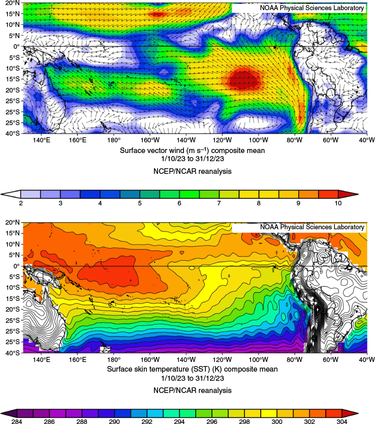
Reanalysis data for tropical Pacific 23 October 2023 to 31 December 2023: top, surface winds; bottom sea surface temperatures. Images sourced from the NCEP NCAR Reanalysis (see https://psl.noaa.gov/data/composites/day/).
Reanalysis data for tropical Pacific 1 November 1982 to 31 January 1983: top, surface winds; bottom, sea surface temperatures. Images sourced from the NCEP NCAR Reanalysis (see https://psl.noaa.gov/data/composites/day/).
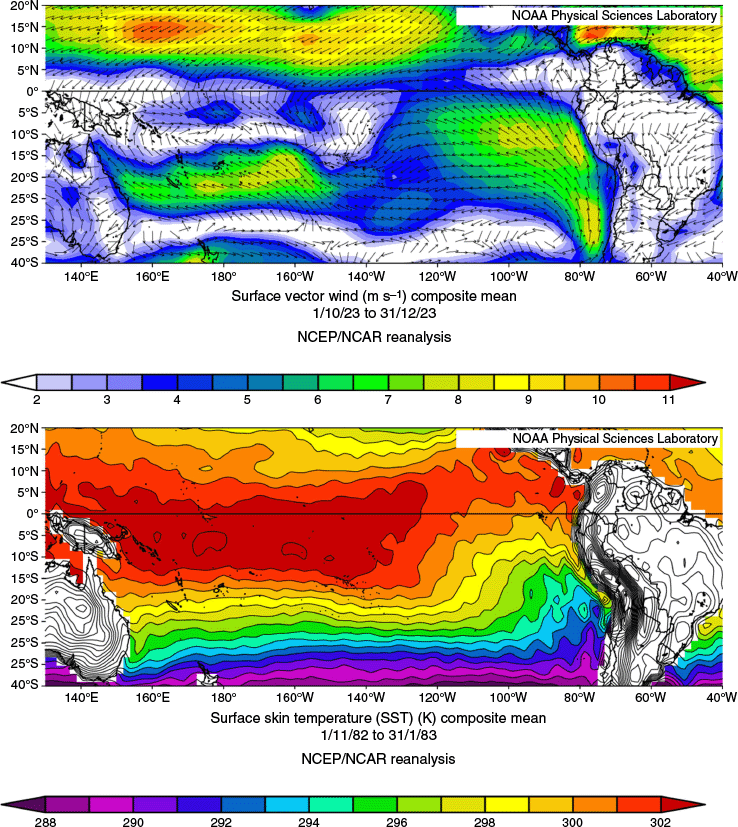
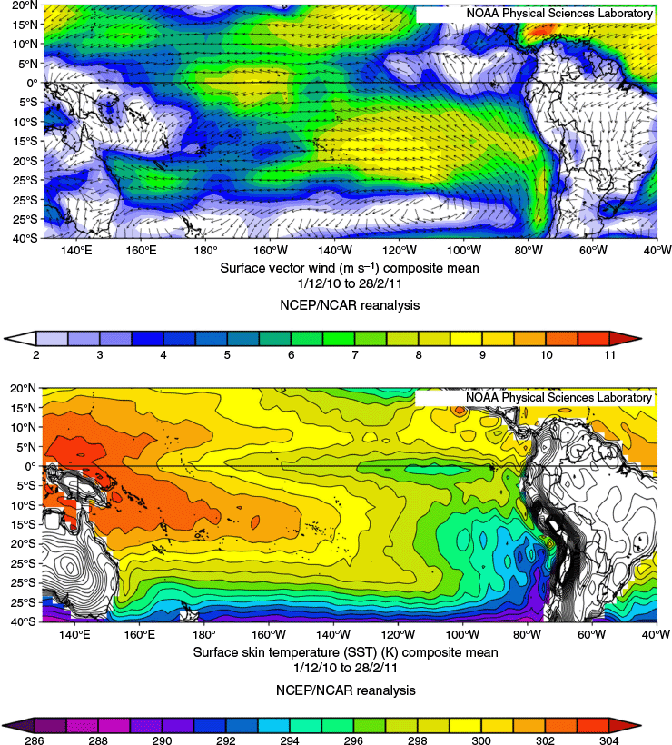
Fig. A4 is the 3-month mean for a strong La Niña (SOI monthly readings were December 2010 +27.1, January 2011 +19.9, and February 2011 +22.3) and shows easterly winds mostly dominating in the Pacific apart from across Papua New Guinea (PNG), the Solomons and the northern Coral Sea. The equatorial warm maximum was over PNG. Overall, these values are more like the 2023 event, and whether this has anything to do with the above-to-very much above average rainfall in eastern Australia during November and December 2023 should be examined (Fig. A5).
Reanalysis data for tropical Pacific 1 December 2010 to 28 February 2011: top, surface winds; bottom, sea surface temperatures. Images sourced from the NCEP NCAR Reanalysis (see https://psl.noaa.gov/data/composites/day/).
Australian rainfall deciles for 1 November 2023 to 31 December 2023. Image sourced from the Australian Bureau of Meteorology.
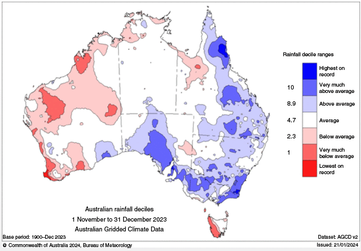
Fig. A6 shows the 3-month mean for the La Niña during the record January 2023 Auckland floods; the pattern resembles the La Niña event shown in Fig. A3 with equatorial easterlies and a warm equatorial SST maximum around PNG. The SOI values were +20.0 for December 2022, +11.8 for January 2023 and +10.5 for February 2023.
Reanalysis data for tropical Pacific 1 December 2022 to 28 February 2023: top, surface winds; bottom, sea surface temperatures. Images sourced from the NCEP NCAR Reanalysis (see https://psl.noaa.gov/data/composites/day/).
Appendix 2.Cairns extreme rainfall
Extreme rainfall at Cairns occurred without evidence of 850-hPa onshore winds turning anticlockwise in direction right up to the 500-hPa level. This occurred with thunderstorms developing in very humid tropical conditions without the anticyclonically turning winds or at least with a shallower layer of these turning winds. In Callaghan (2017b), it was shown how anticyclonic turning up tothe ~700-hPa level in humid unstable tropical conditions can be associated with extreme rainfall. The events found are reported here in Tables A1–A3 and it is noted that they were all associated with cold thermal troughs at the 700- or 500-hPa level extending mostly from higher latitudes up to Cairns.
| 26 February 2000 240 mm in 24 h | Low level south-easterly surge moved up to the monsoon trough near Cairns with a 700-hPa thermal trough over Cairns. Most rain fell between 11:00 hours UTC 25 February 2000 and 20:00 hours UTC 25 February 2000 | |
| Cairns RAWINS in knots 11:00 hours UTC 105/12 (943 hPa) 100/16 (850 hPa) 110/18 (700 hPa) 210/04 (500 hPa) | ||
| Cairns RAWINS 19:00 hours UTC 130/08 (943 hPa) 120/24 (850 hPa) 130/16 (700 hPa) 095/20 (500 hPa) | ||
| 16 January 1985 248 mm in 24 h | Heavy rain and heavy showers – 101 mm in 6 h to 0800 hours UTC 15 January 1985 and 82 mm 6 h to 17:00 hours UTC. Strong monsoon trough north of Cairns with marked 700-/500-hPa thermal trough extending up to Cairns | |
| Cairns RAWINS 22:00 hours UTC 150/21 (943 hPa) 130/33 (850 hPa) 100/27 (700 hPa) 170/12 (500 hPa) | ||
| Cairns RAWINS 04:00 hours UTC 100/19 (943 hPa) 110/21 (850 hPa) 150/37 (700 hPa) 150/21 (500 hPa) | ||
| Cairns RAWINS 10:00 hours UTC 120/23 (943 hPa) 110/19 (850 hPa) 110/23 (700 hPa) 090/19 (500 hPa) | ||
| Cairns RAWINS 16:00 hours UTC 110/19 (943 hPa) 120/35 (850 hPa) 100/21 (700 hPa) 160/10 (500 hPa) | ||
| 17 April 1984 187 mm in 24 h | Marked cold 500-hPa thermal trough extends up to Cairns – XXTS, XXSH and rain with 150 mm 02:00 to 11:00 hours UTC | |
| Cairns RAWINS 22:00 hours UTC 110/10 (943 hPa) 060/04 (850 hPa) 230/02 (700 hPa) 290/16 (500 hPa) | ||
| Cairns RAWINS 04:00 hours UTC 120/19 (943 hPa) 120/23 (850 hPa) 150/16 (700 hPa) 310/19 (500 hPa) | ||
| Cairns RAWINS 10:00 hours UTC 100/14 (943 hPa) 070/12 (850 hPa) 120/12 (700 hPa) 250/16 (500 hPa) | ||
| 18 February 1968 192 mm in 24 h | 94 mm 17:00 hours UTC obs., 37 mm 20:00 hours UTC obs. and 53 mm 23:00 hours UTC obs. from rain and showers. South-easterly wind surge with 500-hPa thermal trough extending up to Cairns | |
| Cairns RAWINS 11:00 hours UTC (950 hPa) 150/19 (850 hPa) 160/12 (700 hPa) 160/19 (500 hPa) | ||
| Wind 17:00 hours UTC 200/08 (950 hPa) 160/12 (850 hPa) 160/14 (700 hPa) 150/29 (500 hPa) | ||
| 19 February 1962 203 mm in 24 h | Reported as rain and most fell between 23:00 hours UTC and 08:00 hours UTC showers – south-easterly surge up to monsoon trough – 500-hPa thermal trough extends up to Cairns | |
| Cairns RAWINS 05:00 hours UTC 180/12 (950 hPa) 110/23 (850 hPa) 110/25 (700 hPa) 110/25 (500 hPa) |
Mostly unidirectional winds (knots) or shallow WAA at Cairns. XXTS, heavy thunderstorm, XXSH, heavy showers.
| 11 February 1994 178 mm in 24 h | Showers and thunderstorms – heaviest 78 mm in 3 h to 03:00 hours – 500-hPa thermal trough extending back towards Cairns from SE (Tropical Upper Troposhere Trough) | |
| Cairns RAWINS 11:00 hours UTC 10 February 1994 140/10 (950 hPa) 100/08 (850 hPa) 110/06 (700 hPa) 160/08 (500 hPa) | ||
| Cairns RAWINS 17:00 hours UTC 10 February 1994 140/08 (950 hPa) 130/06 (850 hPa) 280/04 (700 hPa) | ||
| 22 January 1987 | 213 mm in TS between 04:00 and 06:00 hours UTC 22 January 1987. Thermal trough extended up towards Cairns whereas actual data show 850 hPa warms by +2.50°C increasing static instability | |
| Cairns RAWINS 11:00 hours UTC 21 January 1987 360/12 (950 hPa) 280/08 (850 hPa) 260/08 (700 hPa) 140/08 (500 hPa) | ||
| Cairns RAW 17:00 hours UTC 21 January 1987 330/08 (950 hPa) 280/06 (850 hPa) 300/06 (700 hPa) 220/02 (500 hPa) |
| 7 February 1985 241 mm in 24 h | Heaviest report 98 mm at 06:00 hours – violent showers reported – marked 500-hPa thermal trough passed over Cairns | |
| Cairns RAWINS 22:00 hours UTC 5 February 1985 090/12 (950 hPa) 060/19 (850 hPa) 050/19 (700 hPa) 060/17 (500 hPa) | ||
| Cairns RAWINS 04:00 hours UTC 6 February 1985 109/17 (950 hPa) 090/19 (850 hPa) 010/14 (700 hPa) 040/10 (500 hPa) | ||
| Cairns RAWINS 10:00 hours UTC 6 February 1985 120/14 (950 hPa) 070/26 (850 hPa) 060/14 (700 hPa) | ||
| Cairns RAWINS 16:00 hours UTC 6 January 1985 100/19 (950 hPa) 080/19 (850 hPa) 080/17 (700 hPa) 090/21 (500 hPa) | ||
| 17 January 1985 218 mm in 24 h | Heaviest rain evenly distributed. Heavy rain and heavy showers reported – strong monsoon trough north of Cairns with marked 700/500-hPa thermal trough extending up to Cairns | |
| Cairns RAWINS 22:00 hours UTC 15 January 1985 090/19 (950 hPa) 100/23 (850 hPa) 050/12 (700 hPa) 130/14 (500 hPa) | ||
| Cairns RAWINS 04:00 hours UTC 16 January 1985 120/25 (950 hPa) 110/37 (850 hPa) 090/27 (700 hPa) 060/12 (500 hPa) | ||
| Cairns RAWINS 10:00 hours UTC 16 January 1985 130/35 (950 hPa) 120/41 (850 hPa) 110/25 (700 hPa) 110/16 (500 hPa) | ||
| Cairns RAWINS 16:00 hours UTC 16 January 1985 130/27 (950 hPa) 120/09 (850 hPa) 120/23 (700 hPa) 180/25 (500 hPa) | ||
| 10 March 1983 218 mm in 24 h | Mixture of rain showers and thunderstorms – low developing in the Gulf – 500-hPa thermal trough crosses from NW Queensland to Cairns region | |
| 120 mm in 6 h to 17:00 hours UTC 9 March 1983 and 56 mm in 3 h to 23:00 hours UTC 9 March 1983 | ||
| Cairns RAWINS 22:00 hours UTC 8 March 1983 050/08 (950 hPa) 030/17 (850 hPa) 040/12 (750 hPa) 040/12 (700 hPa) 300/16 (500 hPa) | ||
| Cairns RAWINS 04:00 hours UTC 9 March 1983 060/12 (950 hPa) 010/16 (850 hPa) 350/17 (750 hPa) 360/06 (700 hPa) 300/12 (500 hPa) | ||
| Cairns RAWINS 10:00 hours UTC 9 March 1983 (950 hPa) 060/14 (850 hPa) 110/08 (750 hPa) 120/12 (700 hPa) 010/05 (500 hPa) | ||
| Cairns RAWINS 23:00 hours UTC 9 March 1983 150/14 (950 hPa) 080/14 (850 hPa) 050/06 (750 hPa) 120/06 (700 hPa) 360/12 (500 hPa) | ||
| 13 February 1980 194 mm in 24 h | South-easterly surge up to monsoon trough with 500-hPa thermal trough extending back towards Cairns from SE (TUTT type) – 114 mm in 3 h to 06:00 hours – XXRA and XXSH lightning seen early but no thunder | |
| Cairns RAWINS 16:00 hours UTC 12 February 1980 140/19 (950 hPa) 120/17 (850 hPa) 100/12 (700 hPa) 140/14 (500 hPa) | ||
| 11 February 1977 157 mm in 24 h | 100 mm reported at 03:00 hours in rain – south-easterly surge up to monsoon trough – 700-hPa thermal trough comes close to Cairns over the period with strong meridional thermal gradient over Cairns (producing warm air advection for 700-hPa inshore flow) | |
| Cairns RAWINS 22:00 hours UTC 9 February 1977 170/27 (950 hPa) 130/37 (850 hPa) 120/23 (700 hPa) 290/31 (500 hPa) | ||
| Cairns RAWINS 10:00 hours UTC 10 February 1977 130/35 (950 hPa) | ||
| Cairns RAWINS 16:00 hours UTC 10 February 1973 150/25 (950 hPa) 140/39 (850 hPa) 120/21 (700 hPa) 140/14 (500 hPa) | ||
| 12 December 1973 178 mm in 24 h | Showers and rain heaviest 72 mm 6 h to 05:00 hours UTC 11 December 1973 55 mm 17:00 hours UTC rain and showers 500-hPa thermal trough extending up to NQ over the period | |
| Cairns RAWINS 22:00 hours UTC 10 December 1973 110/17 (950 hPa) 080/25 (850 hPa) 040/08 (700 hPa) 250/11 (500 hPa) | ||
| Cairns RAWINS 04:00 hours UTC 11 December 1973 150/23 (950 hPa) 130/12 (850 hPa) 010/06 (700 hPa) 360/08 (500 hPa) | ||
| Cairns RAWINS 10:00 hours UTC 11 December 1973 120/23 (950 hPa) 110/29 (850 hPa) 140/17 (700 hPa) 250/04 (500 hPa) | ||
| Cairns RAWINS 16:00 hours UTC 11 December 1973 150/14 (950 hPa) 080/14 (850 hPa) 120/06 (700 hPa) 360/12 (500 hPa) | ||
| 13 December 1973 230 mm in 24 h | Rain and showers evenly distributed with heaviest 60 mm in 3 h to 21:00 hours. 500-hPa thermal trough extending up to NQ | |
| Cairns RAWINS 22:00 hours UTC 11December 1973 140/17 (950 hPa) 070/25 (850 hPa) 030/06 (700 hPa) 270/14 (500 hPa) | ||
| Cairns RAWINS 04:00 hours UTC 12 December UTC 110/29 (950 hPa) 060/14 (850 hPa) 080/17 (700 hPa) 250/10 (500 hPa) | ||
| Cairns RAWINS 16:00 hours UTC 12 December 1973 130/17 (950 hPa) 090/08 (850 hPa) 090/08 (700 hPa) 310/10 (500 hPa) | ||
| Cairns RAWINS 22:00 hours UTC 12 December 1973 090/17 (950 hPa) 090/17 (850 hPa) 040/14 (700 hPa) 230/12 (500 hPa) | ||
| 25 March 1969 202 mm in 24 h | 700-hPa thermal trough extends up to Cairns | |
| Cairns RAWINS 05:00 hours UTC 24 March 1969 150/10 (950 hPa) 090/23 (850 hPa) 090/19 (750 hPa) 110/14 (700 hPa) 270/06 (500 hPa) | ||
| Cairns RAWINS 11:00 hours UTC 24 March 1979 160/16 (950 hPa) 090/25 (850 hPa) 090/23 (750 hPa) 090/23 (700 hPa) 220/08 (500 hPa) | ||
| Cairns RAWINS 23:00 hours UTC 24 March 1969 140/10 (950 hPa) 110/23 (850 hPa) 110/18 (750 hPa) 060/14 (700 hPa) 210/10 (500 hPa) | ||
| Heaviest rainfall 102 mm at 17:00 hours UTC, showers and rain | ||
| 17 March 1965 153 mm in 24 h | 131 mm reported in 03:00 hours obs. from heavy rain – south-easterly surge with 500-hPa thermal trough extending up to Cairns | |
| Cairns RAWINS 11:00 hours UTC 16March 1965 150/17 (950 hPa) 110/17 (850 hPa) 090/23 (750 hPa) 120/12 (700 hPa) 090/17 (500 hPa) | ||
| Cairns RAWINS 17:00 hours UTC 16 March 1965 170/21 (950 hPa) 120/29 (850 hPa) 110/21 (750 hPa) 140/23 (700 hPa) 140/26 (500 hPa) | ||
| 6 March 1964 17 mm in 24 h | Heavy showers and rain – 500-hPa thermal trough extends up to Cairns | |
| Cairns RAWINS 05:00 hours UTC 5 March 1964 130/08 (950 hPa) 080/31 (850 hPa) 060/19 (750 hPa) 070/19 (700 hPa) 120/17 (500 hPa) | ||
| Cairns RAWINS 11:00 hours UTC 5 March 1964 040/19 (950 hPa) 050/27 (850 hPa) 060/39 (750 hPa) 070/29 (700 hPa) | ||
| 17:00 hours UTC 5 March 1964 130/10 (950 hPa) 080/25 (850 hPa) 050/19 (750 hPa) 050/21 (700 hPa) 120/19 (500 hPa) | ||
| 22 February 1962 197 mm in 24 h | 102 mm reported at 03:00 hours in rain – 700/500-hPa thermal trough with cooling at Cairns most evident at 700 hPa | |
| Cairns RAWINS 17:00 hours UTC 21 February 1962120/12 (950 hPa) 120/17 (850 hPa) 110/17 (750 hPa) 090/12 (700 hPa) |