
Impacts of South Atlantic Ocean thermal variability on changes in drylands in Argentina
Pedro Samuel Blanco A B C * and Moira Evelina Doyle A B C
A
B
C
Abstract
This study analyses dryland changes in Argentina between 1961 and 2022, as well as the South Atlantic Ocean Dipole (SAOD) impacts on these changes. Monthly precipitation and mean temperature data, the latter used to calculate potential evapotranspiration (PET), were obtained from the Climatic Research Unit (CRU) database. The Aridity Index (AI) was calculated to define drylands according to the United Nations Convention to Combat Desertification (UNCCD) criteria. Sea surface temperature variability in the South Atlantic was examined using the SAOD index. Drylands in Argentina (50.7%), mainly composed of semiarid climate (29.7%) along with marginal arid (8.9%) and dry subhumid (12.1%) areas, exhibit multiannual and decadal oscillations. A significant positive correlation was found between the SAOD index and Argentine drylands, with an increase in these lands during positive SAOD phases (0.1–4.8%) and a reduction during negative phases (1.7–5.9%). The most pronounced shifts occurred in the central region of the country, where drylands expanded (decreased) eastward (westward) during positive (negative) SAOD phases, which was related to an increase (decrease) in aridity, driven by lower (higher) precipitation and higher (lower) PET. The positive (negative) SAOD phase is characterised by anomalous warming (cooling) in the tropical Atlantic and relative cooling (warming) in the south-western Atlantic, along with a weakened (strengthened) South Atlantic High. These changes in oceanic and atmospheric conditions are closely linked to the occurrence of drier or wetter conditions in Argentina, thereby influencing the extent of drylands across the country. These findings help to understand how teleconnection patterns, particularly the SAOD, influence drylands in Argentina.
Keywords: Argentina, aridification, aridity index, cycles, potential evapotranspiration, precipitation, sea surface temperature, semiarid climate, South Atlantic Ocean Dipole.
1.Introduction
Drylands are areas where atmospheric evaporative demand exceeds the water input from precipitation (Nicholson 2011). These lands are commonly defined using the aridity index (Ullah et al. 2022), which quantifies the environmental water deficit through the relationship between supply and demand in a specific region (Lin et al. 2018; Zomer et al. 2022). In drylands, water availability is limited during certain seasons or much of the year, resulting in recurrent scarcity that forces both natural and human systems to adapt to such hydroclimatic conditions (He et al. 2019; Zhang et al. 2021). From an applied approach, drylands play a significant role in climate regulation and global biophysical processes, as they provide essential ecological services such as carbon sequestration, erosion control, production of plant resources and the conservation of various ecosystems such as forests, grasslands and agricultural lands (Busso and Fernández 2018; Lickley and Solomon 2018; Daramola and Xu 2022; Wang et al. 2023).
Drylands are particularly sensitive to climatic variability, as their relative water scarcity means that small changes in climate can generate significant ecological effects (Wu et al. 2016; Cherlet et al. 2018; Berdugo et al. 2020). In this sense, drylands function as transitional climate zones, characterised by marked climatic and biological gradients that reflect their structural instability (Fu 1992; Huang et al. 2017; Wang et al. 2017, 2021). An example of this situation was observed in the Sahel region in West Africa, where a latitudinal shift of only 1° in the isohyets led to a 30–40% reduction in precipitation between the early and mid-1960s (Hubert and Carbonnel 1987; Nicholson 2011; Organisation for Economic Co-operation and Development Sahel and West Africa Club 2014). This climatic instability, combined with anthropogenic factors, has caused the fragile ecological environment of drylands to be highly vulnerable to desertification (Feng and Fu 2013; Park et al. 2018; Yao et al. 2020; Lian et al. 2021). Desertification is an adverse process of partial or total soil degradation due to the interaction between climatic variability and human activities (United Nations Convention to Combat Desertification 1996), altering its physicochemical properties and reducing its productive capacity (Geist and Lambin 2004; Middleton and Sternberg 2013; Gonzalez and Ghermandi 2021). It is estimated that between 10 and 20% of the global drylands, which house ~250 million people, are affected by different forms of desertification (Reynolds et al. 2007; Sun et al. 2023). Thus, some human practices, such as urbanisation, the conversion of agricultural lands, overgrazing, deforestation and pollution, modify the landscape patterns of drylands (Liu et al. 2019), affecting water and carbon cycles, energy exchanges and ecosystem dynamics (Wang et al. 2023).
In recent decades, global drylands have experienced continuous and accelerated expansion (Ji et al. 2015; Zarch et al. 2015). Regions such as north-east Brazil, Argentine Patagonia and coastal areas of Peru, Colombia and Venezuela have experienced an increase in the spatial extent of drylands (Prăvălie et al. 2019; Chai et al. 2021; Allen et al. 2021; Ullah et al. 2022; Luo et al. 2023). This trend is attributed to an aridity increase, a process known as ‘aridification’, which is driven by a rise in potential evapotranspiration, along with atmospheric warming, and a decrease in precipitation (Ji et al. 2015; Lin et al. 2018; Park et al. 2018). Aridification has serious implications for the sustainable development of drylands, as greater long-term environmental dryness could reduce the availability and accessibility of water for both vegetation and populations (Bass et al. 2023; Ketchum et al. 2023; Li et al. 2024). Although water scarcity is normal in drylands, increased aridity can promote their expansion by reducing soil moisture, which in turn may raise the risk of desertification and compromise the adaptive capacity of ecosystems, as well as strategic sectors such as agriculture and water supply (Moral et al. 2016; Overpeck and Udall 2020). This presents major socioeconomic challenges, such as food insecurity, poverty and forced migrations, which directly threaten population survival in these areas (Williams et al. 2020; Daramola and Xu 2022; Hoffmann 2022).
In the current scientific literature, there is evidence that global changes in aridity and drylands are modulated by teleconnection patterns, through feedback between the atmosphere and oceans (Huang et al. 2017; Guan et al. 2019). These teleconnections imply that alterations in atmosphere–ocean coupling in a specific region can affect the climate of distant regions (Reboita et al. 2021). Previous studies have shown that oceans, particularly changes of sea surface temperature (SST) in the Pacific, Atlantic and Indian Basins, influence temperature and precipitation in drylands (Wang et al. 2017; Hu K et al. 2018; Guan et al. 2019; Hu ZZ et al. 2020). In this way, for example, different teleconnection patterns regulate South America’s climate (Barros et al. 2002, 2008, 2015; Reboita et al. 2021). Several studies have analysed the effects of different Pacific variability modes on South America’s climate, such as the El Niño–Southern Oscillation (ENSO) (Andreoli et al. 2017; Cai et al. 2020; Taschetto et al. 2020) and the Pacific Decadal Oscillation (PDO) (Silva et al. 2020; Power et al. 2021), whereas the impact of the South Atlantic has received less attention.
In the South Atlantic Ocean Basin, Venegas et al. (1997) detected a typical dipole structure in monthly SST anomalies, confirmed years later by De Almeida et al. (2007), which they called the South Atlantic Ocean Dipole (SAOD). This dipolar pattern of SST, with a north-east pole (NEP) and a south-west pole (SWP), is associated with a sea level pressure monopole (SLPm) centred at 30°S and 5°W. These structures are interconnected through heat flows at the atmosphere–ocean interface resulting from the interaction between the oceanic mixed layer and atmospheric fluctuations (Nnamchi et al. 2017). Winds associated with the SLPm generate an SST pattern, characterised by greater temperatures in NEP and lower temperatures in SWP, by producing tension on the ocean surface that affects evaporation processes, latent heat loss and the deepening of the mixed layer (Manta et al. 2024). Once established, the thermal dipole is attenuated by latent heat fluxes (Sterl and Hazeleger 2003). In SWP, subsidence and divergent surface motion direct winds northward, where they split into two branches: one returns south-east toward the South African coast, while the other continues northward. On reaching the equatorial zone, these winds are deflected by the Coriolis force, blowing as westerlies toward NEP, where they converge with winds from the central equatorial coast of Africa, producing vertical movements or convection (Nnamchi and Li 2011).
Several studies have demonstrated that the SAOD variability, represented by its positive and negative phases, significantly influences the South America climatic patterns. During the positive (negative) phase, the NEP experiences anomalous warming (cooling), while the SWP exhibits anomalous cooling (warming), which alters circulation patterns and heat flows in the South Atlantic (Guan et al. 2023). In this oceanic basin, Manta et al. (2024) identified a primary oscillation with an approximate periodicity of 13 years, associated with precipitation changes over eastern South America. Meanwhile, Reboita et al. (2021) and Kayano et al. (2013) observed that the positive (negative) SAOD phases are related to a late (early) onset of the rainy season, drier (wetter) austral summers in south-eastern Brazil and below (above) normal precipitation in scattered areas of the eastern and south-eastern parts of the continent during the austral winter and spring. Bombardi and Carvalho (2011) detected a decrease in precipitation over eastern Brazil during the positive SAOD phase, associated with a low-level anomalous westerly flow over south-eastern Brazil. By contrast, their results show anomalous easterly advection from the equatorial and south-western Atlantic linked to increased precipitation in south-eastern Brazil during the negative SAOD phase. Years later, Bombardi et al. (2014) expanded on these findings and noted that the reduced precipitation during the positive phase is also related to a lower frequency of extratropical cyclones near south-eastern Brazil and an intensification of the Subtropical Jet over subtropical southern South America, suggesting a southward displacement of storm tracks and drier conditions in the eastern part of the continent. By contrast, during the negative phase, they identified a higher density of cyclogenesis off the eastern coast of Brazil, which increases the activity and improves the organisation of the South Atlantic Convergence Zone (SACZ) and the development of extratropical cyclones. They also highlighted that the anomalous warming of the south-western Atlantic during the negative phase is associated with an intensification of the South Atlantic High (SAH) over the western sector of the extratropical South Atlantic and with anticyclogenesis east of the Andes, linked to the northward shift of transient systems. In Argentina, studies on the impacts of SAOD phases on regional climate remain limited. A notable contribution is by Leyba et al. (2023), who found that an increase in moisture transport to south-eastern South America was linked to an anomalous cyclonic circulation over the south-western Atlantic, favoured by cooling in the northern South Atlantic and warming in its south-western sector.
So far, the impacts of South Atlantic SST variability on historical changes in Argentina’s drylands have been understudied. In recent decades, the arid and semiarid areas of the country have expanded owing to significant atmospheric aridification (Blanco and Doyle 2024), and it is highly likely that this expansion is linked to SAOD variations. Understanding the interaction between these factors is crucial for developing adaptation and mitigation strategies against desertification, especially in a country like Argentina, where much of the national economy depends on agriculture (Jozami et al. 2018; Piquer-Rodríguez et al. 2018; Rotili et al. 2019; Brendel et al. 2022; Pellegrini et al. 2022) and more than half of the territory is covered by arid and semiarid climates (Abraham et al. 2014). This study aims to examine the temporal changes in the drylands of Argentina during the 1961–2022 period and, in turn, explore the possible link between SAOD impacts and its associated atmospheric circulation on these changes.
2.Methods
2.1. Study area
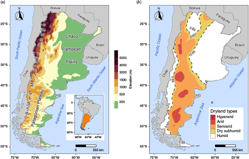
The study area covers continental Argentina, located at the southernmost tip of South America (Fig. 1a). The country is distinguished by three main topographic regions (Pereyra 2019): the Chaco–Pampean Plains (a sedimentary basin with gentle undulations that dominates the eastern sector), the Andes Mountains (an extensive mountain range in the western sector with marked elevation changes), and the Patagonian Plateau (located south of 40°S, characterised by plateaus and basins with altitudes ranging from 200 to 1500 m). This topographic configuration produces notable variability in the country’s climatic conditions. Average annual temperatures range from 5 to 10°C in the south and exceed 20°C in the north. Annual precipitation decreases from 1500 to 1900 mm in the eastern region to ~200 mm in the central-western and southern parts of the country but increases again to over 500 mm south of 35°S in the Andes Mountains. Annual potential evapotranspiration also shows significant contrasts, from ~300 mm in the south to over 1300–1400 mm in the north.
2.2. Data and Aridity Index
This research uses monthly mean temperature and total precipitation of continental Argentina obtained from the Climatic Research Unit (CRU) database, version 4.06 (Harris et al. 2020; Climatic Research Unit and Met Office 2024). The data are available on a grid with a spatial resolution of 0.5° latitude × 0.5° longitude but were reduced to 0.16 × 0.16°, using simple bilinear interpolation, to enhance the analysis of regional climate patterns and visualise changes in drylands in greater detail. Annual temperature and precipitation values were then aggregated for the 1961–2022 period and used to estimate the annual Aridity Index (AI) of the United Nations Environment Programme (1997). This index, defined as the ratio between precipitation (p, mm) and potential evapotranspiration (PET, mm), represents the proportion of water input relative to the maximum possible output (Eqn 1).
AI values are classified into six climatic types: hyperarid (0–0.05); arid (0.05–0.2); semiarid (0.2–0.5); dry subhumid (0.5–0.65); wet subhumid (0.65–1); and humid (>1). These climatic categories indicate that for values below 1, water supply is insufficient to meet atmospheric evaporative demand, and this insufficiency may present varying magnitudes. In hyperarid and arid climates, atmospheric demands significantly exceed precipitation inputs, resulting in prolonged periods of water deficit. In semiarid and dry subhumid climates, this deficit is less pronounced and of shorter duration compared with the water excess periods. In wet subhumid and humid climates, water availability is adequate for most of or even the entire year. As defined by the United Nations Convention to Combat Desertification (1996), drylands include arid, semiarid and dry subhumid climates (0.05–0.65), excluding hyperarid lands and polar regions, which are considered true deserts.
The AI is easily calculated using precipitation and PET data. There are several methods to derive the latter, ranging from simple formulas based on average temperature to more complex ones including more variables. In the present case, the widely used method of Thornthwaite (1948) was selected. It uses a simple algorithm to convert the average temperature into a ‘heat index’, which represents the energy efficiency of temperature in producing evapotranspiration (Proutsos et al. 2021). Uncorrected monthly potential evapotranspiration (PETn, mm month–1) was estimated after applying Eqn 2, 3 and 4:
where Tmi is the monthly mean air temperature for i (°C), from January (1) to December (12), and I is the annual heat index. When the monthly mean temperature is greater than 26.5°C, Eqn 5 is used to calculate PETn:
PETn is corrected considering factors such as latitude and daily sunshine duration applying Eqn 6 and tables developed by Thornthwaite (1948):
where PET is the corrected potential evapotranspiration (mm month–1), and K is the tabulated correction factor based on latitude and month.
2.3. South Atlantic Ocean Dipole Index
The variability of the South Atlantic SSTs was analysed using the SAOD. As indicated in Eqn 7, this index is calculated as the difference between the normalised spatial averages of the SST anomalies (SSTAs) in the regions located to the north-east of the South Atlantic, near the coast of Africa (NEP: 10°E–20°W, 0–15°S), and to the south-west of the South Atlantic, near the coasts of South America (SWP: 10–40°W, 25–40°S) (Fig. 2a). These centres are referred to as the NEP and SWP respectively of the South Atlantic Ocean (Nnamchi et al. 2011, 2013).
where the brackets indicate spatial domain averages, and the sub-indices NEP and SWP represent the poles or regions over which the SSTA averages are estimated. These regions, located in the South Atlantic Basin, correspond to two poles of intense warm (NEP) and cool (SWP) SSTs, which vary reflecting the typical dipolar structure of the SAOD. Therefore, during the negative phase (SAOD < 0), NEP exhibits a lower SSTA than SWP, whereas during the positive phase (SAOD > 0), NEP shows a higher SSTA than SWP.
(a) Geographical location of the north-east pole (NEP, 10°E–20°W, 0–15°S) and south-west pole (SWP, 10–40°W, 25–40°S) regions, used to define the SAOD index, in the South Atlantic Ocean Basin. The average location of the high-pressure monopole (SLPm) is schematised, centred at 30°S and 5°W. (b) SAOD index time series for the 1961–2022 period. The positive and negative phases of the index are shown (shaded).
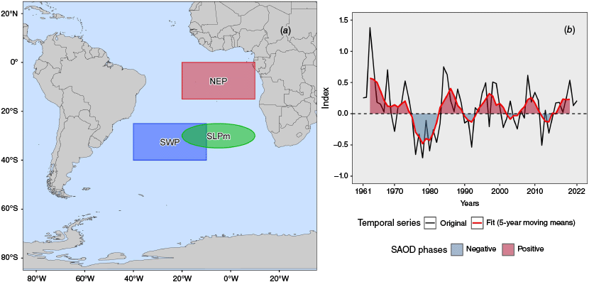
The mean annual time series derived from monthly data of the SAOD index for the period 1961–2022 (De Souza and Reboita 2021; Federal University of Itajubá 2024) were used. A 5-year moving mean filter was applied to this series to identify the SAOD phases. This highlights the long-term cycles of the index and smooths its interannual variability, which could hinder the detection of persistent signals in the teleconnection pattern.
During the study period, positive cycles occurred between 1963 and 1974 (12 years), 1983–1989 (7 years), 1994–2001 (8 years), 2006–2011 (6 years) and 2015–2020 (6 years), whereas negative SAOD cycles occurred between 1975 and 1982 (8 years), 1990–1993 (4 years), 2002–2005 (4 years) and 2012–2014 (3 years) (Table 1). Over the study period, the succession of positive and negative SAOD cycles has decreased in duration and intensity. This suggests that the SAOD phase shifts have accelerated from the 1960s to the present, as SST fluctuations have become less pronounced, and the magnitude of the thermal dipole has diminished owing to less intense warming and cooling (Fig. 2b).
2.4. Statistical methods and circulation analysis
Based on the AI climate classification defined by UNEP and land types according to UNCCD criteria, an average AI field was compiled for the period 1961–2022 to determine the climatological distribution of drylands and their subtypes. Then, the percentage of area occupied by the different types of drylands (total, arid, semiarid and dry subhumid) relative to the country’s total area (2,791,810 km2) was calculated for each year of the study period. A 5-year moving mean was applied to these series to identify cycles of lesser and greater spatial extent of drylands relative to the historical average (1961–2022).
SAOD impacts on drylands were examined using various statistical methods. First, Pearson’s correlation coefficient (r) was calculated between the original SAOD index series and the area of drylands and their associated climates for the period 1961–2022 (Table 2). In addition, the coefficients were calculated for the filtered series using the moving mean method (1963–2020). The significance of the correlations was assessed using Student’s t-test at a 95% confidence level.
| Dryland types | Correlation between original series (1961–2022) | Correlation between filtered series (1963–2020) | |
|---|---|---|---|
| Total drylands | 0.167 | 0.279* | |
| Arid lands | −0.025 | −0.143 | |
| Semiarid lands | 0.231 | 0.562* | |
| Dry subhumid lands | 0.033 | 0.089 |
Additionally, the coefficients for the filtered series using the moving mean method (1963–2020) are shown. Statistically significant coefficients, evaluated using the Student’s t-test, are indicated with 95% confidence (*)
Second, the percentage differences between the moving mean series and the historical average (1961–2022) were quantified for each dryland type (total, arid, semiarid and dry subhumid). The average area occupied by the different types of drylands was estimated for each period associated with the SAOD phases. Then, the differences between the means of each period and the historical average were calculated, and their statistical significance was assessed using Student’s t-test at a 95% confidence level.
Third, based on the sign of the correlations obtained between the SAOD index series and the total extent of drylands, subperiods within each positive (negative) SAOD phase were identified, corresponding to positive (negative) percentage differences relative to the historical average (Table 3). For each of these subperiods, maps were generated showing the average areas of gain, loss and persistence of total drylands, and their respective average values were calculated along with the net change. Gain areas refer to regions that became classified as drylands during the subperiod, whereas loss areas correspond to those that ceased to be classified as such. Persistence regions, by contrast, are areas of total drylands that have remained unchanged relative to the historical climatological conditions. Net change, defined as the difference between gain and loss areas, reflects the balance between regions that became drylands and those that ceased to be, and corresponds to the average of the percentage differences recorded in each subperiod.
| SAOD phase | Period | Subperiod | Percentage difference | |
|---|---|---|---|---|
| Positive | 1963–1974 | 1963–1965 | 2.0 | |
| Negative | 1975–1982 | 1975–1980 | −5.9 | |
| Positive | 1983–1989 | 1989 | 0.1 | |
| Negative | 1990–1993 | 1990–1993 | −2.8 | |
| Positive | 1994–2001 | 1999–2001 | 1.7 | |
| Negative | 2002–2005 | – | – | |
| Positive | 2006–2011 | 2006–2010 | 3.7 | |
| Negative | 2012–2014 | 2012–2013 | −1.7 | |
| Positive | 2015–2020 | 2015–2020 | 4.8 |
The average percentage difference for each subperiod is indicated relative to the historical average. No years with negative percentage differences were found for the negative phase of the 2002–2005 period.
Finally, based on the filtered dryland series, the years with the highest (lowest) positive (negative) percentage differences in total dryland extent relative to the historical average (1961–2022) were selected for each positive (negative) SAOD phase (Table 4). No representative year was selected for the negative phase of the 2002–2005 period, as all corresponding years exhibited positive percentage differences, indicating an increase in total drylands during that time, which could bias the interpretation of the results. Subsequently, maps with aridity index isolines were generated for thresholds of 0.2, 0.5, 0.65 and 1, in order to analyse changes in the boundaries of climate categories. By comparing the location of these isolines in different years with their climatological position, it is possible to identify the shifts that occurred during each SAOD phase. This facilitates detection of changes in climate type boundaries and allows inferences to be made about the expansion or reduction of drylands and their subtypes over time.
| SAOD phase | Period | Year selected | Percentage differences | |
|---|---|---|---|---|
| Positive | 1963–1974 | 1963 | 2.7 | |
| Negative | 1975–1982 | 1976 | −8.6 | |
| Positive | 1983–1989 | 1989 | 0.1 | |
| Negative | 1990–1993 | 1993 | −4.9 | |
| Positive | 1994–2001 | 2000 | 2.3 | |
| Negative | 2002–2005 | – | – | |
| Positive | 2006–2011 | 2007 | 5.9 | |
| Negative | 2012–2014 | 2012 | −1.8 | |
| Positive | 2015–2020 | 2020 | 8.3 |
The corresponding percentage differences for each selected year are indicated. No representative year was selected for the negative phase of the 2002–2005 period, as all corresponding years exhibit positive percentage differences. This suggests an increase of drylands during that period, which could introduce bias into the analysis of the results.
For each SAOD phase, changes in the AI and its associated climate variables (precipitation and PET) were analysed calculating standardised anomalies, following Eqn 8.
where Z is the standardised anomaly of the variable (AI, precipitation or PET), Xi is the observed value of the variable in year i, X̅ is mean and Sx is standard deviation for the 1961–2022 period. Standardised anomalies are dimensionless, and the dataset will have a mean of 0 (zero) and a standard deviation of 1 (one). The idea behind standardised anomalies is to eliminate the influence of location and spread within a dataset (Wilks 2006). Positive (negative) Z values indicate an increase (decrease) with respect to the mean value. Averages of the anomalies corresponding to the positive and negative SAOD phases were calculated.
Annual data from the ERA5 reanalysis (Muñoz-Sabater et al. 2021; Copernicus Climate Change Service 2024) over the South Atlantic Ocean Basin (0–80°S, 70°W–20°E) during the period 1961–2022 were used to examine the atmospheric circulation patterns during SAOD phases. Variables include SST, sea-level atmospheric pressure (SLP), 850-, 300- and 200-hPa zonal (U) and meridional (V) horizontal wind components, 500-hPa geopotential height (HGP), and 500- and 200-hPa air temperature (T). Atmospheric circulation patterns associated with the positive and negative SAOD phases were analysed using composites of cases (years) in each phase. Circulation variable anomalies were calculated by subtracting the composites from the mean field for the 1961–2022 period. SST and SLP were used to identify changes in ocean conditions and low-level pressure systems. Horizontal wind at 850 hPa and geopotential height at 500 hPa were used to assess whether low-level anomalies extended into the mid-troposphere. Combined maps of zonal wind and temperature – U at 300 hPa with T at 500 hPa, and U at 200 hPa with T at 200 hPa – were used to detect changes in upper-level circulation, with particular attention to temperature gradients and to the position and intensity of upper-tropospheric jets.
3.Results
3.1. Spatial distribution of drylands
In Argentina, drylands are distributed from the north-west to the southernmost tip of the country (50.7% of the total area), spanning from the Puna to Extra-Andean Patagonia and along the Atlantic coast from the south-west of Buenos Aires to the north of Tierra del Fuego. They also extend westward from the Sub-Andean Ranges, in the region between 23–27°S and 60–65°W (Fig. 1b). Argentine drylands are dominated by semiarid regions (29.7% of the total area), which contain small arid areas (8.9% of the total area) and are surrounded by dry subhumid zones (12.1% of the total area).
3.2. Temporal variability of drylands
In Argentina, total drylands and their associated climates (arid, semiarid and dry subhumid) show temporal variation during the study period (Fig. 3). Although total drylands occupy, on average, just over half of the country’s surface, this proportion can vary between 40 and 60% over time. Between 1961 and 2022, expansion of drylands over much of the territory was observed in several years, whereas in others, their area significantly decreased, affecting less than half of Argentina. Significant interannual variations in drylands were recorded, ranging from more than 60% of the area (in 1972, 2004, 2009, 2020 and 2022) to below 40% (in 1977, 1986, 1993 and 1995).
Time series of the percentage of area occupied by (a) total drylands and climates, (b) arid, (c) semiarid, and (d) dry subhumid during the 1961–2022 period. For each type of dryland, cycles with areas smaller and larger than the 1961–2022 average are shown (shaded), along with the corresponding average (dashed blue line).
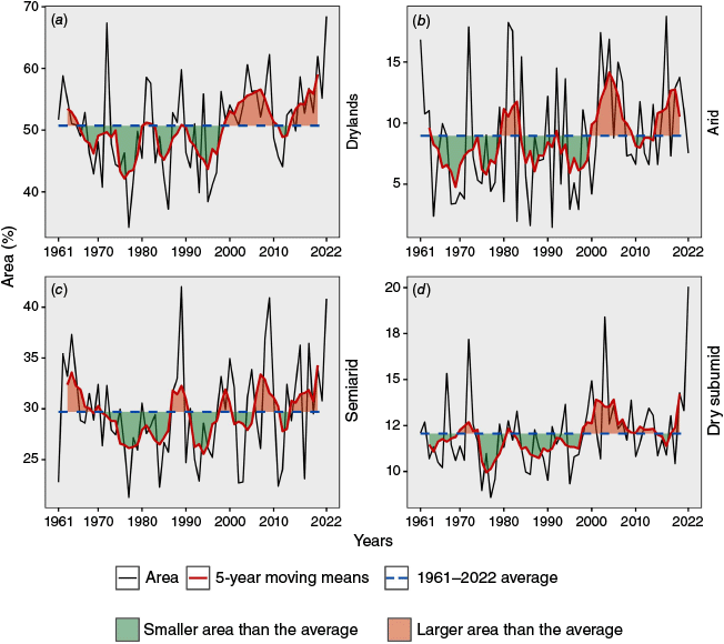
By applying a 5-year moving mean filter to the dryland area series and their associated climates, interannual variability is smoothed, allowing the identification of multiannual and decadal cycles of smaller and larger dryland extent, compared with the 1961–2022 period average. Between the early 1960s and the late 1990s, cycles of smaller dryland extent predominated relative to the average, with some slight upticks c. 1980 and 1990, suggesting a greater extent of wetlands in the country during the second half of the 20th Century. However, from the beginning of the 21st Century to the present, cycles of larger dryland extent than normal have been observed, indicating a sustained increase and expansion of these lands throughout the 21st Century (Fig. 3a).
The area occupied by the arid climate shows similar variability to that of total drylands, although a brief period of greater than normal extent is observed at the beginning of the 1980s (Fig. 3b). The semiarid climate exhibits a succession of smaller and larger area cycles throughout the study period. However, the cycles of smaller semiarid lands have become shorter, whereas those of greater extent have lengthened (Fig. 3c). For instance, cycles of smaller semiarid land extent were recorded between 1971 and 1986 (16 years), 1991–1997 (7 years), 2001–2005 (5 years) and 2012–2013 (2 years), whereas those of greater extent occurred between 1963 and 1968 (6 years), 1987–1990 (4 years), 1998–2000 (3 years), 2006–2011 (6 years) and 2014–2020 (7 years). As for the dry subhumid climate, similar fluctuations to those of total drylands are also observed, with a phase of smaller extent between 1965 and 1997, interrupted in 1970–1974 and 1981, followed by period of greater area from 1998 to 2022, briefly interrupted in 2015 (Fig. 3d). Although semiarid lands predominate in Argentina, arid and dry subhumid lands have a temporal variability that is more aligned with that of total drylands. Semiarid lands, being more extensive, act as central regions characterised by greater climatic stability and a longer response time, meaning their variations are slower or more buffered. By contrast, arid and dry subhumid lands, located at the edges of these central regions, respond more quickly owing to their greater exposure to immediate interaction with the dynamics of semiarid lands and other climatic types.
3.3. Impacts of SAOD on the drylands
Linear correlations between the SAOD series and the percentage area of dryland types in Argentina (Table 2) are positive for semiarid, dry subhumid and total drylands (non-significant), whereas the arid climate presents a negative non-significant correlation. The correlation between the index and the extent of the drylands 5-year moving mean series conserves the same sign, increasing in magnitude (Table 2). In particular, the smoothed SAOD series shows a significant linear association with total drylands and semiarid lands (95% confidence). Although the correlations are low to moderate (r = 0.279 and 0.562), other teleconnections may also influence the drylands, such as the PDO or the Atlantic Multidecadal Oscillation (Huang et al. 2017). Here, only the role of the SAOD in Argentine drylands is explored.
The time series of percentage area differences in total drylands and their associated climates, relative to the 1961–2022 mean, reveal that total drylands (Fig. 4a) exhibit greater variability compared with the fluctuations observed in arid, semiarid and dry subhumid climates (Fig. 4b–d). For instance, in the mid-1970s, the extent of drylands in Argentina decreased between 6 and 9% compared with the historical average, although this reduction was less pronounced in the three climate categories (ranging from 0 to 4%). This situation contrasts with the early 21st Century, where an increase in arid and dry subhumid lands was recorded, while semiarid lands slightly decreased. This resulted in a moderate increase in the drylands, as semiarid regions were replaced by arid and dry subhumid climates.
Time series of the percentage differences for (a) total drylands and climates, (b) arid, (c) semiarid, and (d) dry subhumid during the 1963–2020 period. These differences were calculated by subtracting the moving means of the area percentage of each land type and the corresponding average of the 1961–2022 period. The SAOD phases (shaded) and the area anomaly averages for the different periods related to each phase are shown, along with the statistically significant averages at the 95% confidence level (solid yellow lines).
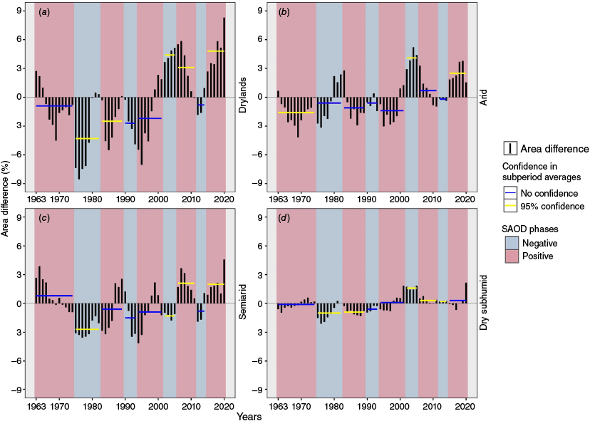
When comparing the series of the three dryland types, dry subhumid lands (Fig. 4d) generally show less variability relative to the historical average, in contrast to arid and semiarid climates (Fig. 4b, c). This suggests that fluctuations in the extent of arid and semiarid climates influence dryland variations in Argentina more significantly. For example, between 2005 and 2019, the spatial extent of dry subhumid lands showed little deviation from the norm, while arid and semiarid climates experienced a progressive increase consistent with total drylands.
Considering each period of the different SAOD phases, the average differences in the percentage of drylands and their associated climates were calculated. Statistical comparison of these averages with the historical average (1961–2022) identified some significant cases with 95% confidence level. In some periods, averages with the same sign were observed in both the positive and negative SAOD phases. For instance, during the periods 1975–1982 (negative phase) and 1983–1989 (positive phase), total drylands showed significant negative differences of −4.3 and −2.5% respectively (Fig. 4a). Also noteworthy are the periods in which both total drylands and some of the three climate types presented statistically significant differences simultaneously. For example, drylands increased significantly compared with the historical average during the positive SAOD phases that occurred during the 2006–2011 and 2015–2020 periods. However, in the first period, significant changes were recorded for the semiarid and dry subhumid climates (Fig. 4c, d), whereas in the second period, significant changes were observed in the arid and semiarid climates (Fig. 4b, c).
Subperiods within each positive (negative) SAOD phase were selected based on positive (negative) percentage differences in the total extent of drylands compared with the historical average (Table 3). For each of these subperiods, the average areas of gain, loss and persistence of total drylands in Argentina were identified (Fig. 5). Persistent areas of drylands predominated in both SAOD phases, while the most significant changes were concentrated along the boundary regions of these lands. During the positive SAOD phases, drylands in Argentina gained more area than they lost. In the subperiods 1963–1965, 1989 and 1999–2001, these gain areas were distributed in continuous bands across the central and north-western regions of the country, while losses appeared as scattered patches along the eastern flank of the Andes (Fig. 5a–c). In the subperiods 2006–2010 and 2015–2020, drylands gained area more extensively and homogeneously, both in the central and north-western regions and in mountainous Andean sectors (Fig. 5d, e). During the negative SAOD phases, by contrast, dryland loss predominated. This was particularly evident in the 1975–1980 subperiod, when continuous areas of loss surrounded the dryland regions of northern and central Argentina (Fig. 5f). In the subperiods 1990–1993 and 2012–2013, losses were mainly concentrated in the central part of the country, while a few isolated areas of gain reappeared in the Andean region (Fig. 5g, h).
Spatial distribution of average areas of gain, loss and persistence (unchanged) of total drylands in Argentina for the selected subperiods, with positive (negative) percentage differences associated with the positive (negative) SAOD phases. Panels (a–e) correspond to positive SAOD phases, and panels (f–h) correspond to negative SAOD phases.
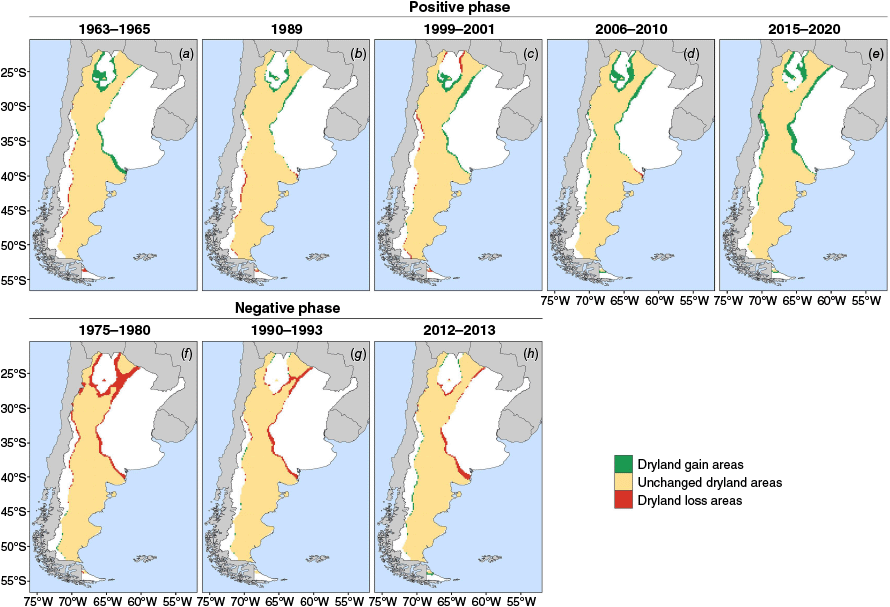
Average percentages of the country’s area with changes and persistence of total drylands were calculated for the selected subperiods according to the different SAOD phases (Table 5). The percentage of areas with persistent drylands ranges from 43.9 to 49.9%, increasing during the positive phase and decreasing during the negative phase. In the positive SAOD phase, there is an increase in areas with dryland gains and a reduction in areas with losses, resulting in a positive net change and a greater spatial extent of drylands in Argentina. The most notable net increases are recorded in the 2006–2010 (3.7%) and 2015–2020 (4.8%) subperiods. By contrast, during the negative SAOD phase, dryland loss areas increase while gain areas decrease, leading to a negative net change and a reduced spatial extent of these lands. The largest net decreases are observed in the 1975–1980 (−5.9%) and 1990–1993 (−2.8%) subperiods.
| SAOD phase | Subperiod | Gain | Loss | Persistence | Net change | |
|---|---|---|---|---|---|---|
| Positive | 1963–1965 | 2.4 | 1.4 | 49.3 | 2.0 | |
| Negative | 1975–1980 | 0.9 | 6.8 | 43.9 | −5.9 | |
| Positive | 1989 | 1.5 | 1.4 | 49.3 | 0.1 | |
| Negative | 1990–1993 | 0.7 | 3.5 | 47.2 | −2.8 | |
| Positive | 1999–2001 | 3.4 | 1.7 | 49.0 | 1.7 | |
| Positive | 2006–2010 | 4.6 | 0.9 | 49.8 | 3.7 | |
| Negative | 2012–2013 | 1.0 | 2.7 | 48.0 | −1.7 | |
| Positive | 2015–2020 | 5.6 | 0.8 | 49.9 | 4.8 |
The values are expressed as a percentage of the total area of the country.
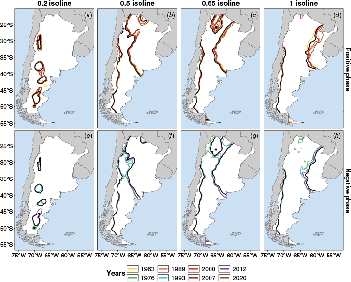
Spatial variability in the position of the characteristic isolines of the aridity index (0.2, 0.5, 0.65 and 1) was analysed for the years with the greatest (smallest) extent of drylands within each positive (negative) SAOD phase (Fig. 6). The selected years, together with the percentage of drylands in each case, are shown in Table 4. The 0.2 isoline, which defines the arid climate, expanded in Patagonia and the central-western region of the country, regardless of the SAOD phases. In the selected years, an increase in arid lands is observed compared with their climatological position (Fig. 6a, e). The 0.5 and 0.65 isolines, which mark the upper boundaries of the semiarid and dry subhumid climates in the central region of the country, shifted eastward during years associated with positive SAOD phases and westward during the selected years with negative phases (Fig. 6b, c, f, g). The 1 isoline (boundary between wet subhumid and humid climates), located in the Chaco–Pampean Plains, showed notable spatial variability, shifting eastward during the selected events in the positive SAOD phase, whereas in the negative phase, it was positioned further west (Fig. 6d, h). In the west of the country, the aridity index isolines (0.5, 0.65 and 1) showed limited horizontal displacement from their climatological position during the selected years in both SAOD phases, probably owing to the topographic barrier that the Andes present to the regional climate.
Spatial variability in the position of aridity index isolines of 0.2, 0.5, 0.65 and 1 during the selected years with the largest (smallest) extent of drylands within each positive (negative) SAOD phase. The solid black line represents the climatological position of the isolines (reference period 1961–2022). Panels (a–d) correspond to positive SAOD phases, and panels (e–h) correspond to negative SAOD phases.
3.4. Role of climatic variables in dryland changes
Spatial distribution of standardised anomalies of the AI and its associated variables (Fig. 7) reveals that, regardless of the SAOD phases, precipitation is the primary factor modulating AI patterns. This is because regions with positive (negative) anomalies in the AI coincide with those that exhibit positive (negative) precipitation anomalies. By contrast, PET shows a different anomaly pattern, suggesting that it may amplify or dampen the precipitation effect.
Standardised anomalies of the aridity index (AI), precipitation (P), and potential evapotranspiration (PET) for the SAOD phases (reference period 1961–2022). The solid black lines with a value of 0 (zero) represent the isolines of 0 standardised anomaly. The dot plot indicates statistically significant anomalies, assessed using the Student’s t-test with 95% confidence. Panels (a–c) correspond to positive SAOD phases, and panels (d–f) correspond to negative SAOD phases.
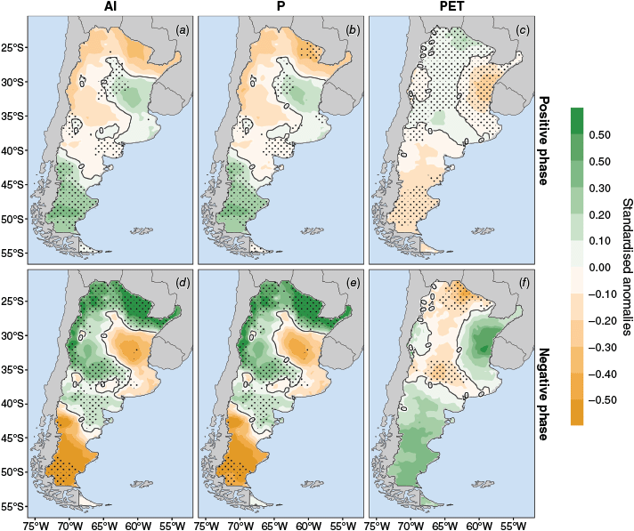
In the positive SAOD phase, precipitation decreases while PET significantly increases in the northern and central-western regions of the country, allowing semiarid and dry subhumid regions to shift eastward, occupying areas that are typically wetter (Fig. 7a–c). In Patagonia and the eastern sector, there is a notable increase in precipitation and a reduction in evaporative demand, though the impact of this combination varies by region. In Patagonia, the increase in precipitation, along with lower atmospheric water demand, generates wetter conditions that reduce the arid climate area and promote the expansion of semiarid climate area. In the central-east sector, higher precipitation and lower PET also favour a more humid environment, though this effect is limited to specific regions owing to the expansion of semiarid and dry subhumid lands from the west.
During the negative SAOD phase, anomaly patterns are nearly opposite to those of the positive phase, though with greater intensity (Fig. 7d–f). Significant positive precipitation anomalies and negative PET anomalies are recorded in the northern and central-western sectors of the country. This increase in water input through precipitation, coupled with lower atmospheric evaporative demand, fosters wetter conditions that reduce the extent of drylands (semiarid and dry subhumid) in these areas. By contrast, the central-eastern and Patagonia regions experience negative precipitation anomalies (particularly significant in the south-western extreme) and positive PET anomalies, leading to more arid regimes.
3.5. Atmospheric circulation associated with SAOD phases
In the South Atlantic Basin, changes in oceanic and atmospheric conditions occur during the SAOD phases that affect aridity and the extent of drylands in Argentina. During the positive SAOD phase, anomalous warming is observed in the tropical Atlantic, near the African coast, along with a relative cooling in the south-western Atlantic, off the southern coast of Brazil. This pattern is accompanied by negative SLP anomalies over the region corresponding to the SAH, indicating a weakening of this system (Fig. 8a). This weakening is also observed in the middle troposphere, through negative HGP anomalies at 500 hPa and an anomalous cyclonic circulation in the central South Atlantic region (Fig. 8c). At upper levels over this region, relative cooling at ~40°S, combined with anomalous warming at higher latitudes (near 60°S), reduces the meridional temperature gradient and weakens the Polar Jet, as indicated by negative zonal wind anomalies at 300 hPa between 40 and 60°S (Fig. 8e). Additionally, positive zonal wind anomalies at 200 hPa between 20 and 40°S, along with anomalous warming in the same zone, indicate an intensification of the Subtropical Jet (Fig. 8g). The combination of a weakened SAH, a weakened Polar Jet and an intensified Subtropical Jet could be associated with reduced moisture advection from the Atlantic toward the continent, especially in the north and central regions of Argentina, favouring drier conditions in these areas.
Atmospheric circulation patterns associated with the positive and negative SAOD phases. (a, b) Anomalies of sea-level pressure (SLP, hPa, negative (positive) values with dashed (solid) lines) and sea surface temperature (SST, °C, shaded). (c, d) Anomalies of geopotential height at 500 hPa (HGP, m, shaded) and horizontal wind at 850 hPa (wind, m s−1, vectors). (e, f) Anomalies of zonal wind at 300 hPa (U, m s−1, negative (positive) values with dashed (solid) lines) and air temperature at 500 hPa (T, °C, shaded). (g, h) Anomalies of zonal wind at 200 hPa (U, m s−1, negative (positive) values with dashed (solid) lines) and air temperature at 200 hPa (T, °C, shaded). The anomalies were calculated relative to the 1961–2022 average.
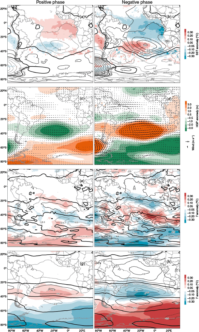
When the negative SAOD phase occurs, the circulation patterns over the South Atlantic are nearly the opposite to those of the positive phase. Widespread cooling is observed in the tropical Atlantic, from the South American to the African coasts, and anomalous warming in the south-western Atlantic, off the Brazilian coast. In the centre of the basin, positive SLP anomalies are observed, indicating an enhanced SAH (Fig. 8b). This pattern is also detected in the middle troposphere through positive HGP anomalies and the associated anomalous anticyclonic circulation (Fig. 8d). At upper levels over the central South Atlantic, anomalous warming at ~40°S and anomalous cooling near 60°S intensify the meridional temperature gradient and strengthen the Polar Jet, as evidenced by positive zonal wind anomalies between 40 and 60°S (Fig. 8f). At the same time, a weakening of the Subtropical Jet is observed, reflected in negative zonal wind anomalies at 200 hPa and anomalous cooling over the South Atlantic between 20 and 40°S (Fig. 8h). A strengthened SAH, together with an intensified and northward-shifted Polar Jet, could be associated with enhanced moisture advection from the Atlantic toward the continent and a more northerly displacement of storm tracks originating from the South Pacific, as suggested by Bombardi et al. (2014), favouring wetter conditions in the central and northern regions of the country.
4.Conclusion
This study analysed the temporal changes in the extent of drylands in Argentina during the 1961–2022 period and examined the relationship between these changes and the variability of the South Atlantic Dipole (SAOD) and its associated atmospheric circulation. The results show that drylands in Argentina, primarily composed of semiarid climates with marginal arid and dry subhumid regions, exhibit multiannual and decadal cycles during which their spatial extent tends to expand or contract over specific periods.
A significant positive correlation was identified between the extent of drylands in Argentina and the SAOD index. In general, drylands increased during the positive SAOD phases, especially in the periods 2006–2010 and 2015–2020, and were reduced during the negative phases, particularly in the periods 1990–1993 and 2012–2013. These changes were not homogeneously distributed across the Argentine territory but were concentrated in the central region, where semiarid and dry subhumid climates shifted eastward (westward) during positive (negative) phases, in relation to an increase (decrease) in aridity associated with lower (higher) precipitation and higher (lower) potential evapotranspiration. By contrast, in Patagonia, arid climate showed a sustained expansion over time without a clear relationship to SAOD phases, whereas in the western part of the country, changes in drylands were less pronounced, likely owing to the topographic barrier imposed by the Andes.
The oceanic conditions and atmospheric circulation associated with different SAOD phases were analysed. During the positive phase, characterised by anomalous warming in the tropical Atlantic and relative cooling in the south-western Atlantic, a weakening of the South Atlantic High (SAH) was observed at low and mid-levels of the atmosphere, along with an intensification of the Subtropical Jet and a weakening of the Polar Jet at upper levels. Conversely, during the negative SAOD phase, the oceanic and atmospheric patterns were reversed, with a strengthened SAH and intensified Polar Jet. These changes in oceanic and atmospheric conditions are closely linked to the occurrence of drier or wetter conditions in Argentina, thereby influencing the extent of drylands across the country.
The results of this study provide evidence of the influence of teleconnection patterns, particularly the SAOD, on the extent of drylands in Argentina. This is particularly relevant for the country, as drylands cover more than half of the national territory and the economy depends heavily on agricultural productivity. In this regard, the findings could serve as a basis for optimising agricultural practices and soil conservation strategies, thereby contributing to the reduction of risks associated with water scarcity.
Data availability
The data can be accessed through the links provided in the paper or will be made available by the corresponding author on request.
Declaration of funding
The research was funded by the National Agency for Scientific and Technological Promotion of Argentina, under FONCYT grant PICT2018-02496 and by the National Council of Scientific and Technological Research of Argentina under PIP grant KE2 11220210100752CO, both received by Dr Moira Doyle.
References
Abraham E, Rubio C, Salomón M, Soria D (2014) Desertificación: problema ambiental complejo de las tierras secas [Desertification: a complex environmental problem of drylands]. In ‘Ventanas sobre el territorio: herramientas teóricas para comprender las tierras secas [Windows on the territory: theoretical tools for understanding drylands]’. (Eds LM Torres, E Abraham, G Pastor) pp. 187–264. (EDIUNC: Mendoza, Argentina) [In Spanish]
Allen RP, Arias PA, Berger S, Canadell JG, Cassou C, Chen D, Cherchi A, Connors SL, Coppola E, Cruz FA, Diongue-Niang A, Doblas-Reyes FJ, Douville H, Driouech F, Edwards TL, Engelbrecht F, et al. (2021) Summary for Policymakers. In ‘Climate Change 2021: the Physical Science Basis. Contribution of Working Group I to the Sixth Assessment Report of the Intergovernmental Panel on Climate Change’. (Eds V Masson-Delmotte, P Zhai, A Pirani, SL Connors, C Péan, S Berger, N Caud, Y Chen, L Goldfarb, MI Gomis, M Huang, K Leitzell, E Lonnoy, JBR Matthews, TK Maycock, T Waterfield, O Yelekçi, R Yu, B Zhou) pp. 3–32. (Cambridge University Press: Cambridge, UK, and New York, NY, USA) 10.1017/9781009157896.001
Andreoli RV, de Oliveira SS, Kayano MT, Viegas J, de Souza RAF, Candido LA (2017) The influence of different El Niño types on the South American rainfall. International Journal of Climatology 37, 1374-1390.
| Crossref | Google Scholar |
Barros VR, Grimm AM, Doyle ME (2002) Relationship between temperature and circulation in southeastern South America and its influence from El Niño and La Niña events. Journal of the Meteorological Society of Japan Series II 80, 21-32.
| Crossref | Google Scholar |
Barros VR, Doyle ME, Camilloni I (2008) Precipitation trends in southeastern South America: relationship with ENSO phases and with low-level circulation. Theoretical and Applied Climatology 93, 19-33.
| Crossref | Google Scholar |
Barros VR, Boninsegna JA, Camilloni I, Chidiak M, Magrín GO, Rusticucci M (2015) Climate change in Argentina: trends, projections, impacts and adaptation. Wiley Interdisciplinary Reviews: Climate Change 6, 151-169.
| Crossref | Google Scholar |
Bass B, Goldenson N, Rahimi S, Hall A (2023) Aridification of Colorado River Basin’s snowpack regions has driven water losses despite ameliorating effects of vegetation. Water Resources Research 59, e2022WR033454.
| Crossref | Google Scholar |
Berdugo M, Delgado-Baquerizo M, Soliveres S, Hernández-Clemente R, Zhao Y, Gaitán JJ, Gross N, Saiz H, Maire V, Lehmann A, Rillig MC, Solé RV, Maestre FT (2020) Global ecosystem thresholds driven by aridity. Science 367, 787-790.
| Crossref | Google Scholar | PubMed |
Blanco PS, Doyle ME (2024) Spatial and temporal changes of aridity in Argentina and its relationship with some oceanic–atmospheric teleconnection patterns. Theoretical and Applied Climatology 155, 4601-4620.
| Crossref | Google Scholar |
Brendel AS, del Barrio RA, Campoy JA (2022) Los agrosistemas patagónicos ante escenarios futuros de creciente escasez hídrica. In ‘XIX Reunión Argentina de Agrometeorología: “Producción Armónica y Sustentable”’, 28–30 September 2022, Neuquén, Argentina. (Eds AI Irigoyen, MG Cogliati, P Paez, MF Reyes, L Serio) AT6-004, pp. 101–102. (Asociación Argentina de Agrometeorología) Available at https://www.siteaada.org/_files/ugd/cf1a17_2f530752296445dc92edabb44abeeecc.pdf [In Spanish]
Bombardi RJ, Carvalho LM (2011) The South Atlantic dipole and variations in the characteristics of the South American Monsoon in the WCRP-CMIP3 multi-model simulations. Climate Dynamics 36, 2091-2102.
| Crossref | Google Scholar |
Bombardi RJ, Carvalho LM, Jones C, Reboita MS (2014) Precipitation over eastern South America and the South Atlantic Sea surface temperature during neutral ENSO periods. Climate Dynamics 42, 1553-1568.
| Crossref | Google Scholar |
Busso CA, Fernández OA (2018) Arid and semiarid rangelands of Argentina. In ‘Climate Variability Impacts on Land Use and Livelihoods in Drylands’. (Eds M Gaur, V Squires) pp. 261–291. (Springer: Cham, Switzerland) 10.1007/978-3-319-56681-8_13
Cai W, McPhaden MJ, Grimm AM, Rodrigues RR, Taschetto AS, Garreaud RD, et al. (2020) Climate impacts of the El Niño–Southern Oscillation on South America. Nature Reviews Earth & Environment 1, 215-231.
| Crossref | Google Scholar |
Chai R, Mao J, Chen H, Wang Y, Shi X, Jin M, et al. (2021) Human-caused long-term changes in global aridity. Nature Partner Journals: Climate and Atmospheric Science 4, 65.
| Crossref | Google Scholar |
Climatic Research Unit, Met Office (2024) CRU TS4.06: Climatic Research Unit (CRU) Time-Series (TS) version 4.06 of high-resolution gridded data. (University of East Anglia) Available at https://crudata.uea.ac.uk/cru/data/hrg/cru_ts_4.06/
Copernicus Climate Change Service (2024) ERA5 hourly time-series data on single levels from 1940 to present. In ‘Climate Data Store’. (C3S) 10.24381/cds.adbb2d47
Daramola MT, Xu M (2022) Recent changes in global dryland temperature and precipitation. International Journal of Climatology 42, 1267-1282.
| Crossref | Google Scholar |
De Almeida RAF, Nobre P, Haarsma RJ, Campos EJD (2007) Negative ocean–atmosphere feedback in the South Atlantic Convergence Zone. Geophysical Research Letters 34, L18809.
| Crossref | Google Scholar |
De Souza CA, Reboita MS (2021) Ferramenta para o Monitoramento dos Padrões de Teleconexão na América do Sul. Tool for Monitoring Teleconnection Patterns in South America. Terrae Didatica 17, e02109 [In Portuguese with title and abstract in Portuguese and English].
| Crossref | Google Scholar |
Federal University of Itajubá (2024) South Atlantic Ocean Dipole Index (SAODI). (UNIFEI) Available at https://meteorologia.unifei.edu.br/teleconexoes/indice?id=saodi
Feng S, Fu Q (2013) Expansion of global drylands under a warming climate. Atmospheric Chemistry and Physics 13, 10081-10094.
| Crossref | Google Scholar |
Fu C (1992) Transitional climate zones and biome boundaries: a case study from China. In ‘Landscape Boundaries. Ecological Studies’. (Eds AJ Hansen, F di Castri) pp. 394–402. (Springer: New York, NY, USA) 10.1007/978-1-4612-2804-2_20
Geist HJ, Lambin EF (2004) Dynamic causal patterns of desertification. Bioscience 54, 817-829.
| Crossref | Google Scholar |
Gonzalez SL, Ghermandi L (2021) Overgrazing causes a reduction in the vegetation cover and seed bank of Patagonian grasslands. Plant and Soil 464, 75-87.
| Crossref | Google Scholar |
Guan X, Ma J, Huang J, Huang R, Zhang L, Ma Z (2019) Impact of oceans on climate change in drylands. Science China Earth Sciences 62, 891-908.
| Crossref | Google Scholar |
Guan Y, Li Y, Zhou W, Zou L, Wang X (2023) Statistical characteristics and mechanism of the South Atlantic Ocean Dipole. International Journal of Climatology 43, 6733-6744.
| Crossref | Google Scholar |
Harris I, Osborn TJ, Jones P, Lister D (2020) Version 4 of the CRU TS monthly high-resolution gridded multivariate climate dataset. Scientific Data 7, 109.
| Crossref | Google Scholar | PubMed |
He B, Wang S, Guo L, Wu X (2019) Aridity change and its correlation with greening over drylands. Agricultural and Forest Meteorology 278, 107663.
| Crossref | Google Scholar |
Hoffmann R (2022) Contextualizing climate change impacts on human mobility in African drylands. Earth’s Future 10, e2021EF002591.
| Crossref | Google Scholar |
Hu K, Huang G, Wu R, Wang L (2018) Structure and dynamics of a wave train along the wintertime Asian jet and its impact on East Asian climate. Climate Dynamics 51, 4123-4137.
| Crossref | Google Scholar |
Hu ZZ, Kumar A, Jha B, Huang B (2020) How much of monthly mean precipitation variability over global land is associated with SST anomalies? Climate Dynamics 54, 701-712.
| Crossref | Google Scholar |
Huang J, Li Y, Fu C, Chen F, Fu Q, Dai A, et al. (2017) Dryland climate change: recent progress and challenges. Reviews of Geophysics 55, 719-778.
| Crossref | Google Scholar |
Hubert P, Carbonnel JP (1987) Approche statistique de l’aridification de l’Afrique de l’Ouest. Journal of hydrology 95, 165-183 [In French].
| Crossref | Google Scholar |
Ji M, Huang J, Xie Y, Liu J (2015) Comparison of dryland climate change in observations and CMIP5 simulations. Advances in Atmospheric Sciences 32, 1565-1574.
| Crossref | Google Scholar |
Jozami E, Montero Bulacio E, Coronel A (2018) Temporal variability of ENSO effects on corn yield at the central region of Argentina. International Journal of Climatology 38, 3003-3017.
| Crossref | Google Scholar |
Kayano MT, Andreoli RV, Ferreira de Souza RA (2013) Relations between ENSO and the South Atlantic SST modes and their effects on the South American rainfall. International Journal of Climatology 33, 2008-2023.
| Crossref | Google Scholar |
Ketchum D, Hoylman ZH, Huntington J, Brinkerhoff D, Jencso KG (2023) Irrigation intensification impacts sustainability of streamflow in the Western United States. Communications Earth & Environment 4, 479.
| Crossref | Google Scholar |
Leyba IM, Solman SA, Saraceno M, Martínez JA, Dominguez F (2023) The South Atlantic Ocean as a moisture source region and its relation with precipitation in South America. Climate Dynamics 61, 1741-1756.
| Crossref | Google Scholar |
Li Z, Yang Q, Ma Z, Wu P, Duan Y, Li M, Zheng Z (2024) Aridification and its impacts on terrestrial hydrology and ecosystems over a comprehensive transition zone in China. Journal of Climate 37, 1651-1666.
| Crossref | Google Scholar |
Lian X, Piao S, Chen A, Huntingford C, Fu B, Li L Z, et al. (2021) Multifaceted characteristics of dryland aridity changes in a warming world. Nature Reviews Earth & Environment 2, 232-250.
| Crossref | Google Scholar |
Lickley M, Solomon S (2018) Drivers, timing and some impacts of global aridity change. Environmental Research Letters 13, 104010.
| Crossref | Google Scholar |
Lin L, Gettelman A, Fu Q, Xu Y (2018) Simulated differences in 21st Century aridity due to different scenarios of greenhouse gases and aerosols. Climatic Change 146, 407-422.
| Crossref | Google Scholar |
Liu Z, Ding M, He C, Li J, Wu J (2019) The impairment of environmental sustainability due to rapid urbanization in the dryland region of northern China. Landscape and Urban Planning 187, 165-180.
| Crossref | Google Scholar |
Luo D, Hu Z, Dai L, Hou G, Di K, Liang M, et al. (2023) An overall consistent increase of global aridity in 1970–2018. Journal of Geographical Sciences 33, 449-463.
| Crossref | Google Scholar |
Manta G, Bach E, Talento S, Barreiro M, Speich S, Ghil M (2024) The South Atlantic Dipole via multichannel singular spectrum analysis. Scientific Reports 14, 15534.
| Crossref | Google Scholar | PubMed |
Middleton NJ, Sternberg T (2013) Climate hazards in drylands: a review. Earth-Science Reviews 126, 48-57.
| Crossref | Google Scholar |
Moral F, Redollo F, Paniagua L, García Martín A, Honorio F (2016) Spatial distribution and comparison of aridity indices in Extremadura, southwestern Spain. Theoretical and Applied Climatology 126, 801-814.
| Crossref | Google Scholar |
Muñoz-Sabater J, Dutra E, Agustí-Panareda A, Albergel C, Arduini G, Balsamo G, et al. (2021) ERA5-Land: a state-of-the-art global reanalysis dataset for land applications. Earth System Science Data 13, 4349-4383.
| Crossref | Google Scholar |
Nicholson SE (2011) ‘Drylands climatology.’ (Cambridge University Press) 10.1017/CBO9780511973840
Nnamchi HC, Li J (2011) Influence of the South Atlantic Ocean dipole on West African summer precipitation. Journal of Climate 24, 1184-1197.
| Crossref | Google Scholar |
Nnamchi HC, Li J, Anyadike RN (2011) Does a dipole mode really exist in the South Atlantic Ocean? Journal of Geophysical Research: Atmospheres 116, D15104.
| Crossref | Google Scholar |
Nnamchi HC, Li J, Kang IS, Kucharski F (2013) Simulated impacts of the South Atlantic Ocean Dipole on summer precipitation at the Guinea Coast. Climate Dynamics 41, 677-694.
| Crossref | Google Scholar |
Nnamchi HC, Kucharski F, Keenlyside NS, Farneti R (2017) Analogous seasonal evolution of the South Atlantic SST dipole indices. Atmospheric Science Letters 18, 396-402.
| Crossref | Google Scholar |
Organisation for Economic Co-operation and Development Sahel and West Africa Club (2014) ‘West African Studies: An Atlas of the Sahara-Sahel: Geography, Economics and Security.’ (OECD Publishing: Paris, France) 10.1787/9789264222359-en
Overpeck JT, Udall B (2020) Climate change and the aridification of North America. Proceedings of the National Academy of Sciences 117, 11856-11858.
| Crossref | Google Scholar | PubMed |
Park CE, Jeong SJ, Joshi M, Osborn TJ, Ho CH, Piao S, et al. (2018) Keeping global warming within 1.5°C constrains emergence of aridification. Nature Climate Change 8, 70-74.
| Crossref | Google Scholar |
Pellegrini P, Prado SA, Monzon JP, Oesterheld M, Sadras VO (2022) Spatial and temporal variation in drought types for wheat in Argentina and its association with actual yield and fertilization rate. Field Crops Research 280, 108469.
| Crossref | Google Scholar |
Pereyra FX (2019) Geology and geomorphology. In ‘The soil of Argentina’. (Eds G Rubio, RS Lavado, FX Pereyra) pp. 7–25. (Springer: Cham, Switzerland) 10.1007/978-3-319-76853-3
Piquer-Rodríguez M, Butsic V, Gärtner P, Macchi L, Baumann M, Pizarro GG, et al. (2018) Drivers of agricultural land-use change in the Argentine Pampas and Chaco regions. Applied Geography 91, 111-122.
| Crossref | Google Scholar |
Power S, Lengaigne M, Capotondi A, Khodri M, Vialard J, Jebri B, et al. (2021) Decadal climate variability in the tropical Pacific: characteristics, causes, predictability, and prospects. Science 374, eaay9165.
| Crossref | Google Scholar | PubMed |
Prăvălie R, Bandoc G, Patriche C, Sternberg T (2019) Recent changes in global drylands: evidence from two major aridity databases. Catena 178, 209-231.
| Crossref | Google Scholar |
Proutsos ND, Tsiros I X, Nastos P, Tsaousidis A (2021) A note on some uncertainties associated with Thornthwaite’s aridity index introduced by using different potential evapotranspiration methods. Atmospheric Research 260, 105727.
| Crossref | Google Scholar |
Reboita MS, Ambrizzi T, Crespo NM, Dutra LMM, Ferreira GWDS, Rehbein A, et al. (2021) Impacts of teleconnection patterns on South America climate. Annals of the New York Academy of Sciences 1504, 116-153.
| Crossref | Google Scholar | PubMed |
Reynolds JF, Smith DMS, Lambin EF, Turner BL, Mortimore M, Batterbury SP, et al. (2007) Global desertification: building a science for dryland development. Science 316, 847-851.
| Crossref | Google Scholar | PubMed |
Rotili DH, Giorno A, Tognetti PM, Maddonni GÁ (2019) Expansion of maize production in a semi-arid region of Argentina: climatic and edaphic constraints and their implications on crop management. Agricultural Water Management 226, 105761.
| Crossref | Google Scholar |
Silva MES, Silva CB, Ambrizzi T, Drumond A, Patucci NN (2020) South America climate during the 1970–2001 Pacific Decadal Oscillation phases based on different reanalysis datasets. Frontiers in Earth Science 7, 359.
| Crossref | Google Scholar |
Sterl A, Hazeleger W (2003) Coupled variability and air–sea interaction in the South Atlantic Ocean. Climate Dynamics 21, 559-571.
| Crossref | Google Scholar |
Sun C, Feng X, Fu B, Ma S (2023) Desertification vulnerability under accelerated dryland expansion. Land Degradation & Development 34, 1991-2004.
| Crossref | Google Scholar |
Taschetto AS, Ummenhofer CC, Stuecker MF, Dommenget D, Ashok K, Rodrigues RR, Yeh SW (2020) ENSO atmospheric teleconnections. In ‘El Niño–Southern Oscillation in a changing climate’. (Eds MJ McPhaden, A Santoso, W Cai) pp. 309–335. (American Geophysical Union) 10.1002/9781119548164.ch14
Thornthwaite CW (1948) An approach toward a rational classification of climate. Geographical Review 38, 55-94.
| Crossref | Google Scholar |
Ullah S, You Q, Sachindra DA, Nowosad M, Ullah W, Bhatti AS, et al. (2022) Spatiotemporal changes in global aridity in terms of multiple aridity indices: an assessment based on the CRU data. Atmospheric Research 268, 105998.
| Crossref | Google Scholar |
United Nations Convention to Combat Desertification (1996) Part I: introduction – article 1: use of terms. In ‘United Nations Convention to Combat Desertification in those countries experiencing serious drought and/or desertification, particularly in Africa’. (Ed. United Nations) pp. 4–5. (United Nations: Geneva, Switzerland) Available at https://catalogue.unccd.int/936_UNCCD_Convention_ENG.pdf
United Nations Environment Programme (1997) Chapter 1: global (climatic surfaces and designation of aridity zones). In ‘World Atlas of Desertification’. (Eds N Middleton, D Thomas, UNEP) pp. 1–7. (UNEP: London, UK) Available at https://digitallibrary.un.org/record/245955
Venegas SA, Mysak LA, Straub DN (1997) Atmosphere–ocean coupled variability in the South Atlantic. Journal of Climate 10, 2904-2920.
| Crossref | Google Scholar |
Wang L, Chen W, Huang G, Zeng G (2017) Changes of the transitional climate zone in East Asia: past and future. Climate Dynamics 49, 1463-1477.
| Crossref | Google Scholar |
Wang Q, Wang L, Huang G, Piao J, Chotamonsak C (2021) Temporal and spatial variation of the transitional climate zone in summer during 1961–2018. International Journal of Climatology 41, 1633-1648.
| Crossref | Google Scholar |
Wang H, Liu Y, Wang Y, Yao Y, Wang C (2023) Land cover change in global drylands: a review. Science of The Total Environment 863, 160943.
| Crossref | Google Scholar | PubMed |
Williams AP, Cook ER, Smerdon JE, Cook BI, Abatzoglou JT, Bolles K, et al. (2020) Large contribution from anthropogenic warming to an emerging North American megadrought. Science 368, 314-318.
| Crossref | Google Scholar | PubMed |
Wu M, Schurgers G, Rummukainen M, Smith B, Samuelsson P, Jansson C, et al. (2016) Vegetation–climate feedbacks modulate rainfall patterns in Africa under future climate change. Earth System Dynamics 7, 627-647.
| Crossref | Google Scholar |
Yao J, Liu H, Huang J, Gao Z, Wang G, Li D, et al. (2020) Accelerated dryland expansion regulates future variability in dryland gross primary production. Nature Communications 11, 1665.
| Crossref | Google Scholar | PubMed |
Zarch MAA, Sivakumar B, Sharma A (2015) Assessment of global aridity change. Journal of Hydrology 520, 300-313.
| Crossref | Google Scholar |
Zhang C, Yang Y, Yang D, Wu X (2021) Multidimensional assessment of global dryland changes under future warming in climate projections. Journal of Hydrology 592, 125618.
| Crossref | Google Scholar |
Zomer RJ, Xu J, Trabucco A (2022) Version 3 of the global aridity index and potential evapotranspiration database. Scientific Data 9, 409.
| Crossref | Google Scholar | PubMed |