

Enhancing river flows v. environmental engineering as contrasting approaches to wetland conservation in the Murray–Darling Basin, Australia
Peiqin Ziang A , Matthew J. Colloff A * and Jamie Pittock A
A
Abstract
In regulated river basins, wetland conservation has focussed on managed environmental flows to achieve outcomes. Two approaches have emerged, one based on ecological principles, the other on environmental engineering.
To compare these approaches, as applied in the southern Murray–Darling Basin, namely, the Constraints Management Strategy (CMS), based on reducing constraints on within-channel flows to enable flooding of wetlands, and the Victorian Murray Floodplain Restoration Project (VMFRP), based on infrastructure to divert water onto floodplains.
We used data from official reports to derive flood frequency, duration and extent and compare economic costs and water use.
At five wetlands along the Murray River, CMS and VMFRP achieved similar flood frequency and duration. CMS achieved similar or greater flood extent except at two of five sites and required no clearance of floodplain trees. CMS was almost 10 times cheaper to implement and with lower water price per hectare.
There was no clear economic or environmental advantage to implementing VMFRPs, given that CMS will be implemented under water reforms in the Murray–Darling Basin Plan.
We consider there is a strong case for the Victorian government to reconsider the need to implement the VMFRPs.
Keywords: climate change, environmental flows, flow extent and duration, flow frequency, regulated rivers, river operations, water reform policy, wetland vegetation.
Introduction
Freshwater ecosystems worldwide are under increasing pressure from effects of water resource development, river regulation and diversions for consumptive use, combined with the impacts of agricultural development and climate change (Vörösmarty et al. 2010; Greve et al. 2018). Declines in wetland extent have increased markedly since the 1950s, primarily because of land-use changes such as drainage for cultivation and urban development (Fluet-Chouinard et al. 2023). Ecological degradation of rivers has been extensive owing to multiple stressors including nutrient pollution, river regulation, alteration to flow regimes and longitudinal and lateral connectivity (Feio et al. 2023). Attempts to restore the ecological condition of wetlands in regulated river basins have focussed on the use of managed environmental flows to reinstate elements of the natural flow regime or, where freshwater ecosystems have been altered substantially, by designing environmental flows to achieve specific ecological processes and outcomes (Acreman et al. 2014; Arthington et al. 2023).
With increased urgency to conserve freshwater ecosystems, two approaches have emerged, namely, one based on principles of restoration ecology and the other on environmental engineering (Opperman et al. 2009; Pittock and Lankford 2010; Spieles 2022). The former approach emphasises that restoration activities (such as revegetation, erosion control and removal of invasive species) occur along a continuum of ecosystem modification and degradation, depending on local context (Hobbs and Norton 1996). For wetlands this approach includes reinstating at least some elements of the natural flow regime by managed releases of environmental water from headwater dams to meet the water requirements of flow-dependent biota and reducing the volume of diversions so as to provide ecological benefits (Bunn and Arthington 2002; Arthington and Pusey 2003; Acreman et al. 2014). The latter approach, which includes construction of infrastructure in wetlands and rivers already modified from natural conditions has been criticised for failing to account for drivers of ecosystem change and ignoring critical ecohydrological processes, resulting, for example, in the disconnection of floodplain wetlands from their rivers (Pittock et al. 2013; Knox et al. 2022).
The Murray–Darling Basin in south-eastern Australia (hereafter ‘the Basin’) is an example of a highly regulated drainage basin containing degraded wetlands and rivers (Davies et al. 2010, 2012) caused by combined effects of climate change, river regulation and irrigation water diversions, with negative effects on wetland biota (Kingsford et al. 2017). The Basin covers 1.06 × 10⁶ km2 of south-eastern Australia and contains ~30,000 wetlands of 25,000 km2 in area, including 6363 km2 of some 16 Ramsar wetlands (Murray–Darling Basin Authority 2010, pp. 59, 63). Irrigated agriculture accounts for 46% of total surface water use (CSIRO 2008, pp. 28, 32) and many irrigation districts are close to major wetlands. Rivers and wetlands of the Basin were heavily modified during the 19th century. Major stressors included grazing, timber harvesting and land clearing (Colloff 2014; Colloff et al. 2015), followed by river regulation and irrigation water diversions, which increased sharply between 1950 and 1990 (Kingsford 2000; Colloff et al. 2015). In terms of river regulation, over a 1000 weirs, at least 100 large dams and hundreds of kilometres of levee banks have been constructed in the past 120 years (Arthington and Pusey 2003; Kingsford et al. 2017), although the precise number of these structures has not been determined. In just over a century, the Basin had been transformed from natural, free-flowing rivers with long traverses across semi-arid floodplains and large terminal wetlands into a system of highly regulated rivers and extensive irrigation areas, with major negative effects on the ecological condition of wetlands and their flow regimes.
Attempts at ecological restoration in the Basin involve the use of both ecological restoration by reducing irrigation diversions and managed releases of environmental water and environmental engineering. In this paper, we examine these two approaches to wetland conservation by using examples from wetlands along the Murray River.
Background and context: water reform in the Murray–Darling Basin
The Basin has been the subject to major policy reforms since the recognition in the 1980s that water resources were over-allocated for irrigation and, later, that climate change and drought have exacerbated environmental decline (Grafton 2010). These reforms led to the Water Act 2007 (Cth) (hereafter, ‘the Water Act’) and the 2012 Murray–Darling Basin Plan (hereafter, the ‘Basin Plan’) to restore water from consumptive use to the environment. This process involves water buy-backs from irrigators, irrigation efficiency programs and enforceable limits on the volume of irrigation diversions in each catchment. The water recovered for environmental purposes is then released as managed environmental flows in those catchments that have large headwater dams (mostly in the southern Basin) or through restrictions placed on pumping water from rivers in catchments that lack such dams (mostly in the northern Basin).
The Basin Plan is a legislative instrument of the Water Act, implemented by the Murray–Darling Basin Authority (MDBA) in partnership with the Basin jurisdictions (Queensland, South Australia, New South Wales, Victoria and the Australian Capital Territory). The Water Act requires the Commonwealth and Basin State and Territory governments to manage water resources according to the principles of ecologically sustainable development and gives effect to Australia’s obligations to international environmental treaties. These agreements include the Ramsar Convention on Wetlands (United Nations Educational, Scientific and Cultural Organization 1994) and the Convention on Biological Diversity (United Nations 1992); both being of particular relevance to the conservation of wetlands in the Basin.
The Basin Plan involves implementing the Sustainable Diversion Limit (SDL) to restore water to the environment, but has been heavily contested. Lobbying by irrigator groups has led to less water being recovered for the environment than first intended (Grafton et al. 2020). The original environmental water recovery target (water to be returned from irrigators) under the Basin Plan was 3000–7600 GL year−1 (Murray–Darling Basin Authority 2010), but was reduced to 2800 GL year−1 and then 2075 GL year−1, a volume considered insufficient to achieve environmental objectives of the Water Act and the Basin Plan (Young et al. 2011). This ‘step-down effect’ (Colloff and Pittock 2022) has created a growing gap between the volume of water required to maintain and restore wetlands and rivers and the volume that will be recovered and used for the environment under the Basin Plan.
The most recent reduction in the water recovery target is the result of the Sustainable Diversion Limit Adjustment Mechanism (SDLAM), which is intended to achieve the same environmental outcomes but with a lower volume of managed environmental water releases. This objective entails a reduction of 605 GL year−1 in the recovery target. The water saved is then available to irrigators. The SDLAM operates as an environmental offset mechanism, where negative environmental impacts from water diversions are said to be balanced by more effective environmental water delivery (Lyons et al. 2023). SDLAM includes three types of measures intended to achieve the 605 GL target (Murray–Darling Basin Authority 2025). These are as follows: (1) supply measures, which include (a) environmental works, involving infrastructure construction on floodplains (pumps, regulators, culverts, levees and channels) to divert water from rivers and retain it in wetlands, and (b) operational rules changes, involving alteration of rules on how the river system is run to improve ecological benefits of environmental flows (Murray–Darling Basin Authority 2017a, 2022a); (2) constraints measures, intended to overcome limits on volumes of environmental water that can be released from headwater storages by allowing overbank flows onto floodplains while mitigating adverse effects on private landholders (Murray–Darling Basin Authority 2013; Kahan et al. 2021), and (3) efficiency measures, intended to reduce consumptive water use to save water for the environment, including upgrading of irrigation systems and improved irrigation efficiency. Of the 37 SDLAM projects, most involve environmental works (Murray–Darling Basin Authority 2024a), but the successful operation of many of these depends on constraints measures and operational rule changes that have yet to be implemented. According to the most recent assessment of supply and constraints measures (Aurecon Australasia Ltd 2024), 13 projects are operational, 10 are likely to be operational by 31 December 2026, 12 will not be operational by that date or delivered only in part and two have been withdrawn. There is likely to be a shortfall of up to 315 GL year−1 in the 605 GL year−1 target (Murray–Darling Basin Authority 2023).
Constraints management and the Victorian Murray Floodplain Restoration Project
The Victorian Government contributes to the SDLAM through the Victorian Constraints Management Program, the Enhanced Environmental Water Delivery Project and the Victorian Murray Floodplain Restoration Project (VMFRP). The VMFRP involves infrastructure to flood ~14,000 ha of nine floodplain wetlands along the Murray River (Fig. 1) (Victorian Murray Floodplain Restoration Project 2023a, summary document, p. 5). Examples of what the VMRP projects attempt to achieve include installing regulators to lower flow thresholds for floods at Nyah from 25,000 to 20,000 ML day−1, at Vinifera from 20,000 to 17,500 ML day−1, and at Burra Creek from 35,000 to 30,000 ML day−1 (Murray–Darling Basin Authority 2022b). When completed, VMFRP will flood 23% of wetland vegetation communities within the project area at a cost of A$281.1 × 10⁶, but it does not account for risks to the ecological condition of the broader floodplain (Bender et al. (2023). Five VMFRP wetlands are within an area subject to the Commonwealth Government Basin-wide Constraints Management Strategy (CMS) (Fig. 1). The CMS involves removing physical and operational constraints that limit most environmental water released in the southern Basin to within-channel flows (Chen et al. 2021). These constraints mostly involve physical restrictions (imposed by river regulation infrastructure, bridges and roads) and legal limitations (associated with property rights and irrigation water entitlements) on how much environmental water can be released from dams to reconnect rivers to their floodplains as often and as extensively as needed without affecting people’s livelihoods (Murray–Darling Basin Authority 2013, 2024b). Relaxing constraints would enable overbank flows to flood low-lying areas, including private land, to provide water to wetlands that could not previously be flooded (Murray–Darling Basin Authority 2013, 2024b; Kahan et al. 2021).
The southern Murray–Darling Basin with sites for the Victorian Murray Floodplain Restoration Project (VMFRP) and the area subject to the Constraints Management Strategy (CMS).

Given that the CMS will be implemented regardless under the Water Amendment (Restoring Our Rivers) Act 2023 (Cth), as part of the Murray–Darling Basin Plan (Murray–Darling Basin Authority 2024b), the following questions arise: is implementing VMFRP the most practical and effective approach for conservation of wetlands? Could CMS offer a cheaper, more flexible alternative that can supply environmental water to a larger area? Our aim herein is to compare the ecohydrological and economic efficacy of the two approaches.
Methods
Study sites
We included five (six forest areas) of the nine VMFRP sites, as follows: Gunbower, Guttrum and Benwell forests, Vinifera, Nyah and Burra Creek, which are within the CMS reach from Yarrawonga to Wakool Junction (Fig. 1). We did not include the other four VMFRP sites because they are located outside the CMS area. Our analyses were based on flooding of major vegetation communities for which conservation objectives are set under the Basin-wide Environmental Watering Strategy (Murray–Darling Basin Authority 2019): river red gum (Eucalyptus camaldulensis) forest and woodland, lignum (Duma florulenta) shrubland and black box (Eucalyptus largiflorens) woodland.
Basic site details are given here. Gunbower National Park, 60 km north-west of Echuca is part of Gunbower Forest Ramsar site (Hale and Butcher 2011), located on Gunbower Island between the Murray River and its anabranch, Gunbower Creek. The VMFRP site is located at the southern end of Gunbower Island in the area referred to as upper Gunbower National Park (North Central Catchment Management Authority 2014a, fig. 2-1 and 2-2 therein) and covers 3025 ha of wetlands, river red gum forests and black box woodlands (North Central Catchment Management Authority 2014a, p. 44). Guttrum (1269 ha) and Benwell (660 ha) forests, ~15 km north-west of Barham, are river red gum forests containing many large, old trees. Floods are now approximately half as frequent and last for half as long as prior to river regulation and irrigation diversions (North Central Catchment Management Authority 2014b, p. 14). The Vinifera Floodplain (637 ha), just south-east of Nyah, includes seasonal wetlands (98 ha), river red gum forest (278 ha) and woodland (161 ha) and black box woodland (87 ha). Before river regulation, flooding commenced in spring at flows of >12,500 ML day−1 at Swan Hill and most of the forest would have been flooded with flows of 17,500 ML day−1 (Mallee Catchment Management Authority 2015a). Nyah Park (913 ha), located 30 km upstream of Swan Hill, includes seasonal wetlands (45 ha), river red gum forest (168 ha) and woodland (576 ha) and black box woodland (64 ha). Before river regulation, annual natural flows >25,000 ML day−1 would flood most of the forest (Mallee Catchment Management Authority 2015b). Burra North (1217 ha) is downstream of Nyah and Vinifera, 10 km upstream of the confluence of the Wakool River with the Murray. It contains seasonal wetlands (100 ha), lignum shrubland (687 ha) and black box and river red gum woodlands (417 ha). Before river regulation, flooding commenced at 17,500 ML day−1 at Swan Hill. Low-lying areas were flooded at 27,500 ML day−1 and black box woodlands at 30,000 ML day−1 (Mallee Catchment Management Authority 2015c).
Flow targets for flood events
We used the flow targets (ML day−1), as cited in reports and business cases for VMFRP and CMS. Flow targets are the flow rates that are intended to be achieved at each site under VMFRP and CMS and were used by the project proponents to model flood events that meet objectives for flood frequencies and durations (cf. Supplementary material Table S1 for details and references). Flow targets for floods under CMS at Torrumbarry and Barham were from Department of Planning, Industry and Environment (2024), although we note that flow rates in the Murray River at these gauges do not fully determine flood thresholds at Gunbower and Guttrum and Benwell because irrigation channels and pipelines are also used to deliver environmental water (North Central Catchment Management Authority 2014a, 2014b). Flow targets for floods under CMS at Swan Hill were not documented by Department of Planning, Industry and Environment (2024) but were estimated on the basis of the assumption that they would be lower than those at Barham (cf. Table S1).
The scenarios of pre-regulation, current (regulated, without Basin Plan) and Basin Plan in Table S1 are those cited by the project proponents and are standard scenarios used in the MDBA MSM-BigMod and Source model runs from which the proponents derived their data (cf. Gippel 2014a, pp. 1, 2; Murray–Darling Basin Authority 2022a, p. 2). Definitions are as follows: (1) pre-regulation: the likely flow regime before regulation of the Murray–Darling Basin; (2) current: the flow regime under current conditions, with river regulation and water resource development, but without the Basin Plan, based on modelled flow scenarios over a 114-year period to 2009; (3) Basin Plan: the flow regime that would be realised by implementing the Basin Plan; and (4) Basin Plan with VMFRP, i.e. the flood frequency and duration the VMFRPs are intended to achieve in addition to those achieved under the Basin Plan (Victorian Murray Floodplain Restoration Project 2023a, p. 6.17). This scenario assumes implementation of the Basin Plan without CMS (Gippel 2014a, 2014b). For CMS, we used two flow rates of 30,000 ML day−1 and 40,000 ML day−1 (hereafter referred to as CMS30 and CMS40) with implementation of the Basin Plan but without VMFRP and with CMS30 and CMS40 being implemented separately. These were the flow rates that were modelled for CMS under RRCP (Department of Planning, Industry and Environment 2024).
Frequency and duration of flood events
Data on the frequency and duration of VMFRP equivalent flow rates, i.e. natural flows the VMFRPs are designed to mimic and achieve, were documented in Victorian Murray Floodplain Restoration Project (2023a, vol. 1, pp. 6.19, 6.32), Victorian Murray Floodplain Restoration Project (2023b, attachment 1, p. 6.44) and North Central Catchment Management Authority (2014a, 2014b).
We estimated CMS flood frequency and duration because these had not been documented in the hydraulic model outputs for the Reconnecting River Country Program (RRCP) by Department of Planning, Industry and Environment (2024). We first determined CMS equivalent flows. CMS equivalent flows at Gunbower and Guttrum and Benwell were from gauge data at Torrumbarry and Barham respectively, documented by Department of Planning, Industry and Environment (2024). We estimated CMS equivalent flow rates at Nyah, Vinifera and Burra Creek (gauged at Swan Hill) because they had not been documented. Given that Swan Hill is downstream of Barham, and there are no major inflow tributaries between these two gauges, flow rates would be the same or lower than at Barham. Therefore, we estimated CMS equivalent flow rates at Swan Hill as the same as at Barham to avoid overestimating frequency and duration.
Having determined CMS equivalent flow rates, we then calculated their frequency and duration on the basis of data from the spells analysis by Gippel (2014a) by using the following equations:
Flow rates A and B are the closest data points above and below each CMS equivalent flow given by Gippel (2014a, 2014b). We assumed a linear relationship between each pair of flow rates and that there are 30 days in each month (Gippel 2014a, 2014b gives duration in days; we use months).
Based on the RRCP data (Department of Planning, Industry and Environment 2024), the frequency of environmental water delivery will be 4–5 years in 10 years (Department of Planning, Industry and Environment 2024), the duration of delivery of high flows (>30,000 ML day−1) will be for up to 21 days and occasional low flows (15,000–30,000 ML day−1) for up to 30 days. These ranges are not set limits but represent a guide to the most likely outcomes. Given most environmental water delivered under CMS will be ‘piggybacked’ on natural high flows to generate floods (NSW Department of Primary Industries 2016, p. 7; Murray–Darling Basin Authority 2022c), we extended only five equivalent flow events in 10 years under the Basin Plan scenario by 30 days for CMS30 and four events by 21 days for CMS40. For example, the frequency of flow events of 20,000 ML day−1 at Nyah (equivalent to 30,000 ML day−1 downstream of Yarrawonga Weir; Table S1) is 7.9 times per decade, and median duration is 3.1 months. Assuming that the actual duration of these flow events is 3.1 months, if environmental flows under CMS30 are delivered five times per decade, the actual duration of 5 of these 7.9 events will be extended by 1 month, so there will be five events of 4.1 months and three events of 3.1 months. The median duration of flow events at Nyah under CMS30 will be 4.1 months.
We also estimated VMFRP and CMS performance under projected future climate scenarios, on the basis of flow characteristics detailed by Murray–Darling Basin Authority 2022b, 2022c).
Optimal range of flood frequency and duration for vegetation communities
We determined whether floods under VMFRP and CMS were of adequate frequency and duration to maintain wetland vegetation communities. We used water requirements of wetland plants by Roberts and Marston (2011) to assess optimal ranges of flood frequency and duration to maintain the major vegetation communities (Table S2). Maintenance conditions represent ‘flooding characteristics to maintain plants in good to vigorous condition’ (Roberts and Marston 2011, p. 2).
Estimation of flood extent for wetland vegetation communities
Two hydraulic models have been constructed to estimate flood extent; one for the VMFRP and the other for CMS. The VMFRP model shows maps of the maximum area that could be flooded if the projects are implemented (Victorian Murray Floodplain Restoration Project 2024). The RRCP model, designed to estimate extent of impact on landholders affected by CMS, generates flood maps for the following four flow rates downstream of Yarrawonga Weir: 15,000, 25,000, 30,000 and 40,000 ML day−1 (Department of Planning, Industry and Environment 2024). We used maps for CMS30 and CMS40, in line with CMS business cases (Murray–Darling Basin Authority 2013; NSW Department of Primary Industries 2016). These maps show ‘likely’ flood extents, which occur under typical catchment conditions and environmental flow-release durations, and ‘upper limit’ extents for wet catchment conditions and flows significantly longer than usual environmental flow releases (Department of Planning, Industry and Environment 2024). We used only the likely flood extents.
The VMFRP and RRCP maps of flood extent were imported into ArcGIS Pro (ver. 3.0.3, Esri, Redlands, CA, USA) using the WGS 1984 Web Mercator (auxiliary sphere) projected coordinate system. Images were converted from. TIF format to raster format (pixel size: 1 m2), and the ‘training sample’ function was used to enable identification of flooded and non-flooded areas. Next, all pixels were categorised into the following five groups: flood, wetland, forest, developed areas and barren land using the maximum likelihood classification. Initially, flooded areas were assigned a value of 1 and the four other categories a value of 0. Then, for flooded areas a value of 0.6 was assigned to the processed VMFRP rasters, 0.4 to the processed RRCP rasters of CMS30 and 0.8 to those of CMS40. These values simply code for different colours for flood extent under VMFRP and CMS. VMFRP and RRCP maps for each site were overlaid and boundary layers created manually to exclude the Murray River from the flooded areas. Flood extent under VMFRP, CMS30 and CMS40 was then calculated by counting pixels of each of the assigned values.
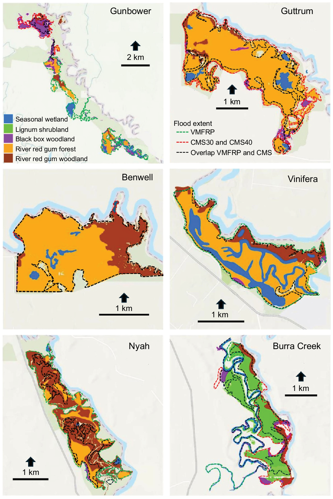
To determine whether optimal flood frequency and duration for major vegetation communities would be achieved under CMS and VMFRP, we first determined the extent of each vegetation community at each site. Shapefiles of ecological vegetation classes (EVCs) were downloaded from NatureKit (Department of Energy, Environment and Climate Action 2024a) and used as masks to determine flood extent for individual EVCs at each site. We then aggregated results for EVCs to vegetation communities according to the VMFRP Ecological Water Regime Class (Table S3; Victorian Murray Floodplain Restoration Project 2023a, vol. 4, attachment VI, p. 34) to show overlaps and differences in flood extent of river red gum, lignum and black box achieved by VMFRP and CMS. We compared our estimates of flood extent for VMFRP with those in the VMFRP business cases.
Cost and use of environmental water
Total water use for each environmental water delivery event under VMFRP is documented in the business cases (North Central Catchment Management Authority 2014a, 2014b; Mallee Catchment Management Authority 2015a, 2015b, 2015c). Total water use (ML) for each environmental water delivery under CMS was estimated using the following equation:
Flow rates were from RRCP (Department of Planning, Industry and Environment 2024, gauge information). Total water use was higher than net water use because it included return flows, i.e. environmental water returned to the river and available for downstream sites (Jacobs and GHD 2022, p. 124). Return flow volumes for VMFRP at Gunbower and Guttrum and Benwell were from North Central Catchment Management Authority (2014a, 2014b). Volumes of total water use for VMFRP at Nyah, Vinifera and Burra Creek were from Mallee Catchment Management Authority (2015a, 2015b, 2015c), although return flows have not been modelled (Jacobs and GHD 2022, p. 124). We calculated these using the same return-flow rate, 26% (Colloff and Pittock 2022, Table S1), as for the CMS. Net water use for each environmental water delivery for CMS and VMFRP was calculated using the following equation:
The cost of water use per decade was calculated as follows:
An allocation price of A$80 ML−1 was used (Walsh et al. 2023). The costs of implementing the CMS per site were not assessed owing to complexities of converting system-scale costs to site scale.
Results
Flood frequency and duration
With Basin Plan implementation, flood frequency under CMS is similar or greater than that under VMFRP, except at Vinifera, where for CMS30 it is 1.1 events per decade fewer than for VMFRP (Table 1). Flood frequency of CMS40 is 0.2–2.2 events per decade fewer than that of VMFRP. Flood duration for CMS is similar or longer than under VMFRP, with floods under CMS30 lasting 0.2–1.5 months longer and those under CMS40 −0.1 to 2.6 months longer.
| Site | Frequency (events per decade) | Median duration (months) | |||||||
|---|---|---|---|---|---|---|---|---|---|
| VMFRP | CMS30 | CMS40 | Optimal | VMFRP | CMS30 | CMS40 | Optimal | ||
| Gunbower | 6.0 | 6.3 | 5.2 | 1.4–3.3 | 3.0 | 3.6 | 3.4 | 2–6 | |
| Guttrum and Benwell | 8.0 | 8.1 | 7.4 | 3.3–10 | 3.5 | 4.0 | 3.4 | 5–7 | |
| Vinifera | 9.0 | 7.9 | 6.8 | 3.3–10 | 3.9 | 4.1 | 3.8 | 5–7 | |
| Nyah | 7.0 | 7.9 | 6.8 | 2.5–5 | 2.5 | 4.1 | 3.8 | 2–4 | |
| Burra Creek | 7.8 | 11.0 | 6.8 | 3.3–10 | 1.2 | 1.6 | 3.8 | 3–7 | |
Optimal ranges for most extensive vegetation communities at each site (river red gum woodland at Nyah, river red gum forest at Guttrum and Benwell and Vinifera, black box woodland at Gunbower and lignum shrubland at Burra Creek) are based on Roberts and Marston (2011) (cf. Table S2). CMS30 and CMS40 median durations were extended by 1 month compared with figures for duration in Table S1: for example, at Nyah and Vinifera, if environmental flows under CMS30 are delivered five times per decade for up to 30 days for CMS30 and 21 days for CMS40 (based on Department of Planning, Industry and Environment 2024), then the duration of 5 of 7.9 natural flow events achieved under the Basin Plan scenario will be extended by 1 month under CMS30 because duration of delivery is up to 30 days; therefore, the median duration of flood events under CMS30 will be 4.1 months, 1 month longer than that under the Basin Plan Scenario and with an extra 0.7 months for CMS40.
VMFRP and CMS both achieve floods with frequencies that meet or exceed the optimal range for water requirements to maintain the major species of the dominant vegetation communities at each site (Tables 1, S2; river red gum woodland at Nyah, river red gum forest at Guttrum and Benwell and Vinifera, black box woodland at Gunbower and lignum shrubland at Burra Creek). Durations fall 1–1.6 months short of optimal for VMFRP and CMS30 and CMS40 at Guttrum and Benwell, 0.9–1.2 months short at Vinifera and 1.8–1.4 months short for VMFRP and CMS30 at Burra Creek, but are within the optimal range at Gunbower and Nyah and for CMS40 at Burra Creek.
Flood extent and implications for vegetation communities
The VMFRP can achieve a flood over the entire Benwell Forest, >80% of Guttrum Forest, Vinifera and Nyah and ~40% of Burra Creek and the Gunbower Forest site. Compared with VMFRP, CMS30 achieves markedly less extensive flooding at three of six sites (Fig. 2, 3). With CMS30, flood extent is 78% less than with VMFRP at Gunbower (limited to the north of the site), 74% less at Nyah (limited to the south-west) and 76% less at Burra Creek (limited mainly to anabranches) (Fig. 2), but is similar at Guttrum (14% more than VMFRP), Benwell (4% less) and Vinifera (29% less), where it overlaps with VMFRP in most areas.
Maps of flood extent under the implementation of the Victorian Murray Floodplain Restoration Project (VMFRP) and the Constraints Management Strategy (CMS).
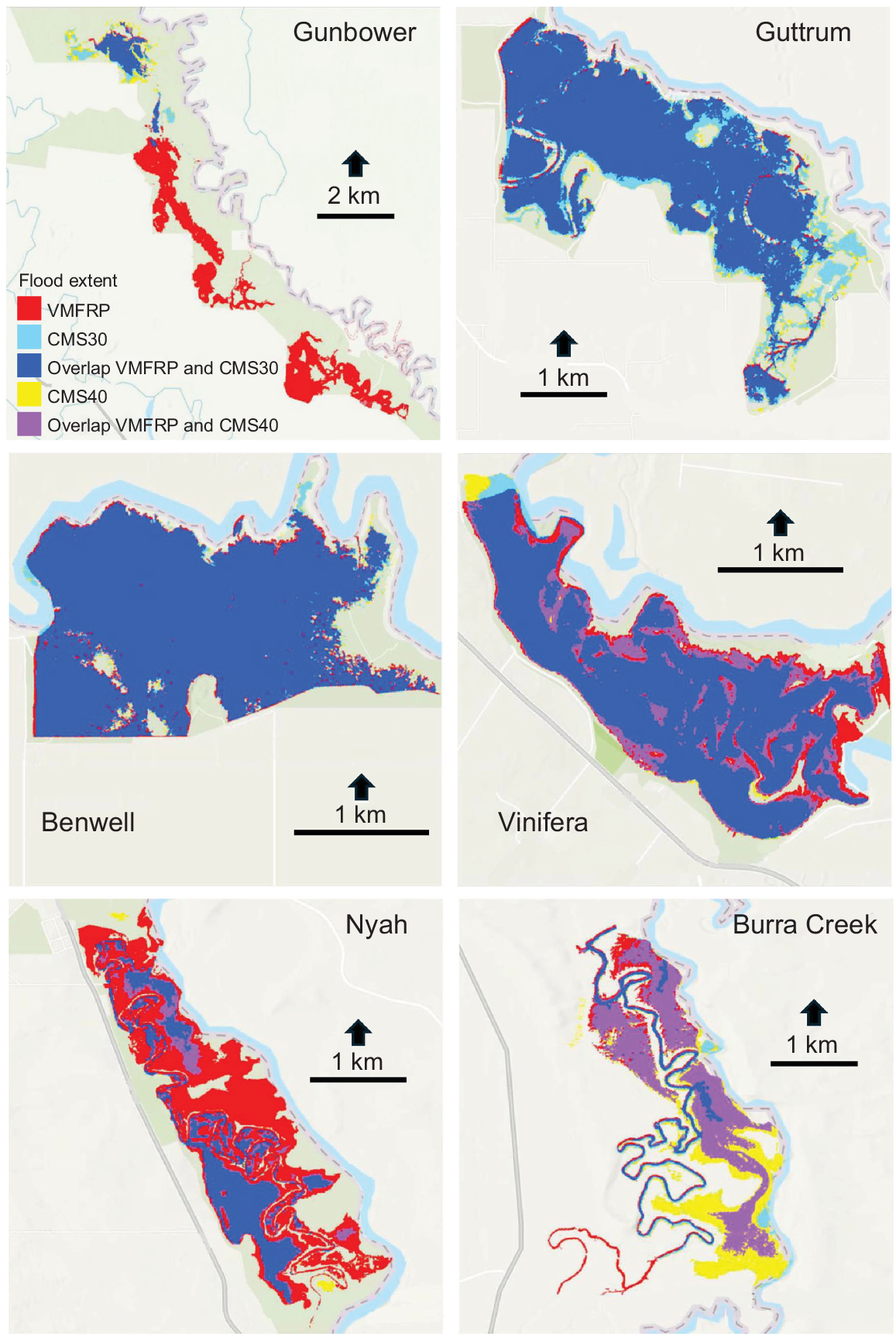
Comparison of estimated flood extent at sites under implementation of the Victorian Murray Floodplain Restoration Project (VMFRP) and the Constraints Management Strategy (CMS).

As expected, CMS40 generates a greater flood extent than does CMS30 at all sites: at Nyah, an additional 80 ha in the north, but not the central region, and covering only 30% of the Park (Fig. 2). At Gunbower, flood extent with CMS40 is 132 ha greater than with CMS30, but additional flooding is limited to the north, covering only 13% of the forest. At Vinifera, flood extent is 111 ha greater with CMS40 than CMS30, nearly the same as under VMFRP, covering 78% of the floodplain. At Burra North, CMS40 floods 53% of the site, which is 524 ha greater than with CMS30 and 138 ha greater than with VMFRP. At Guttrum and Benwell, increases in extent under CMS40 compared with CMS30 are minimal (Fig. 3).
In terms of flooding of vegetation communities, CMS30 and CMS40 achieve similar to or greater flood extent than VMFRP for seasonal wetland, river red gum forest and woodland at Vinifera, Guttrum and Benwell and for black box woodland at Guttrum and Burra Creek (Table 2, Fig. 4). At Burra Creek, CMS40 achieves a flood extent similar to VMFRP for seasonal wetland, a greater extent for lignum shrubland and twice as much for river red gum and black box woodland. At Gunbower, all four vegetation communities are subject to far lower flood extent under CMS than VMFRP (Table 2). At Vinifera, the area flooded by VMFRP but not CMS30 contains mostly river red gum and black box woodland (Fig. 4; Mallee Catchment Management Authority 2015a, p. 19, fig. 4-2) whose water requirements for maintenance are 2.5–5 and 1.4–3.3 events per decade, of 2–4 and 2–6 months duration respectively (Table S2; Roberts and Marston 2011). At Burra Creek, the area not flooded with CMS30 is mainly lignum shrubland, with water requirements for maintenance of 3.3–10 events per decade, of 3–7 months duration. The water requirements for river red gum and black box at Vinifera and lignum shrubland at Burra Creek in areas not flooded by CMS30 can be met by high natural flow events under the Basin Plan scenario where flows exceed 22,000 ML day−1 at Swan Hill (Table S1).
| Item | Seasonal wetland (ha) | River red gum forest (ha) | River red gum woodland (ha) | Black box woodland (ha) | Lignum shrubland (ha) | |
|---|---|---|---|---|---|---|
| Gunbower | ||||||
| VMFRP | 161 | 355 | 119 | 553 | ||
| CMS30 | 2 | 12 | 34 | 215 | ||
| CMS40 | 3 | 13 | 66 | 313 | ||
| Guttrum | ||||||
| VMFRP | 65 | 890 | 76 | 17 | ||
| CMS30 | 66 | 1018 | 90 | 34 | ||
| CMS40 | 66 | 1035 | 93 | 38 | ||
| Benwell | ||||||
| VMFRP | 20 | 520 | 173 | 1 | ||
| CMS30 | 20 | 507 | 161 | 0 | ||
| CMS40 | 20 | 513 | 170 | 0 | ||
| Vinifera | ||||||
| VMFRP | 147 | 297 | 88 | 6 | ||
| CMS30 | 144 | 204 | 39 | 0 | ||
| CMS40 | 146 | 274 | 75 | 3 | ||
| Nyah | ||||||
| VMFRP | 34 | 201 | 500 | 7 | ||
| CMS30 | 7 | 88 | 98 | 1 | ||
| CMS40 | 10 | 104 | 159 | 1 | ||
| Burra Creek | ||||||
| VMFRP | 92 | 52 | 28 | 333 | ||
| CMS30 | 58 | 7 | 8 | 45 | ||
| CMS40 | 70 | 91 | 57 | 425 | ||
Extensive lignum shrubland occurs only at Burra Creek, which lacks river red gum forest.
Costs and water use
The cost of implementing VMFRP at each site mostly involves construction and upgrading of infrastructure to control water movement onto floodplain wetlands. Costs of implementing the CMS involve purchasing of flood easements and compensation to landowners for damage, as well as construction of infrastructure to protect assets and establish or maintain access during floods.
Costs of implementing CMS are much higher than for VMFRPs; at least eight times the cost of individual VMFRPs and three times the total cost (Table 3). However, CMS achieves a far greater flood extent (Fig. 1) than does VMFRP and the cost of VMFRP per unit area is nearly 10 times greater than that of CMS. VMFRP annual operating costs cover maintenance, monitoring and pumping water from the main channel onto the floodplain (A$965,276 at Nyah and A$869,025 at Vinifera; Tickle and Ram 2020a, 2020b). Annual cost of pumping at each site is ~A$200,000, assuming one pumping event every 10 years. Operating costs at other sites are not publicly available, but are likely to be comparable to those at Nyah and Vinifera, given they are similar projects. Compensation to landowners under CMS is likely to be event-based (NSW Department of Primary Industries 2016, p. 13), on the basis of loss or damage to crops, but the cost is not broken down by event, making it difficult to calculate annual operating costs.
| Item | Total flood extent (ha) | Total implementation cost (A$ × 106) | Cost per unit area (A$ ha−1) | Net water use (ML) | Total cost of water (A$ × 106) | Water use per unit area (ML ha−1) | Water cost per unit area (A$ ha−1) | |
|---|---|---|---|---|---|---|---|---|
| VMFRP sites | ||||||||
| Gunbower | 500 | 24 | 48,000 | 2790 | 0.223 | 5.58 | 446 | |
| Guttrum and Benwell | 1200 | 52 | 43,333 | 11,431 | 0.915 | 9.53 | 762 | |
| Vinifera | 350 | 17 | 48,571 | 2030 | 0.162 | 5.80 | 464 | |
| Nyah | 488 | 20 | 40,984 | 2070 | 0.165 | 4.24 | 339 | |
| Burra Creek | 404 | 22 | 54,455 | 2035 | 0.163 | 5.04 | 403 | |
| CMS | ||||||||
| 30,000 ML day−1 | 81,000 | <421 | <5198 | <333,000 | <26.64 | <4.11 | <329 | |
| 40,000 ML day−1 | 105,000 | 448 | 4267 | 326,340 | 26.12 | 3.11 | 249 | |
Sources: Mallee Catchment Management Authority 2015a, 2015b, 2015c), North Central Catchment Management Authority 2014a, 2014b) and NSW Department of Primary Industries, (2016). Note: flood extent (Fig. 2), calculated using ArcGIS, is higher than the documented flood extent in the VMFRP business cases (Column 1; North Central Catchment Management Authority 2014a, 2014b; Mallee Catchment Management Authority 2015a, 2015b, 2015c). This discrepancy was not due to calculation errors in ArcGIS. A request for clarification to the VMFRP proponents failed to elicit a response, so flood extent calculated using ArcGIS was used for comparison of VMFRP projects and the CMS.
Net water use under the CMS is ~150 times greater than under the VMFRP at Nyah, Vinifera and Burra Creek, 100 times greater at Gunbower and 30 times greater at Guttrum–Benwell. But on a per-unit-area basis, average water use and cost of VMFRP is 1.03–3.1 times greater than that of CMS (mean ha−1: 4.2–9.5 v. 3.1–4.1 ML; A$339–762 v. A$249–329).
Implementing VMFRP will require removal of wetland vegetation, involving a mean of nearly 3% of the area intended to be conserved by flooding and over 5% of the area at Nyah. Many large and very large river red gums that provide major biodiversity habitat will need to be felled (Table 4). These adverse ecological impacts have not been translated into monetary terms herein, but have been assessed as high at Vinfera and Nyah and extreme for the removal of large and very large trees at Burra Creek (Victorian Murray Floodplain Restoration Project 2023a, vol. 2A, p. 9.55; vol. 2B, pp. 13.55–13.56; vol. 2C, pp. 17.60–17.61). CMS also involves some vegetation removal (NSW Department of Primary Industries 2016), but details are not documented in the business cases.
| Site | Extent of vegetation clearance (ha) | Vegetation clearance as a percentage of area flooded under VMFRP | Number of large and very large trees to be removed | |
|---|---|---|---|---|
| Gunbower | 19.9 | 4.0 | 66 | |
| Guttrum and Benwell | 13.7 | 1.1 | 143 | |
| Vinifera | 12.8 | 3.7 | 147 | |
| Nyah | 14.1 | 2.9 | 146 | |
| Burra Creek | 21.6 | 5.4 | 188 | |
| Total | 82.1 | 2.8 | 690 |
Sources: Gunbower: Jacobs and GHD (2020a), appendix T. Guttrum and Benwell: Jacobs and GHD (2020b), appendix Q. Vinifera: Victorian Murray Floodplain Restoration Project (2023a), vol. 2A, chapter 9, p. 9.55. Nyah: Victorian Murray Floodplain Restoration Project (2023a), vol. 2B, chapter 13, pp. 13.55, 13.56. Burra Creek: Victorian Murray Floodplain Restoration Project (2023a) vol. 2C, chapter 17, pp. 17.60, 17.61.
Climate change
VMFRP and CMS perform well under wet and medium climate scenarios, but poorly under both 2045 and 2070 dry climate scenarios (Table 5). Under climate change, there will be a significant reduction in the frequency of flow events in the Murray River of sufficient magnitude for the effective operation of the VMFRPs. The performance of CMS under dry climate scenarios is likely to be limited owing to lower environmental water allocations.
| Scenario | Operation opportunities | Environmental water allocation | |||
|---|---|---|---|---|---|
| VMFRP | CMS | VMFRP | CMS | ||
| 2045 Wet | ✓ | ✓ | ✓ | ✓ | |
| 2045 Medium | ✓ | ✓ | ✓ | ✓ | |
| 2045 Dry | ✗ | ✓ | ✓ | ✗ | |
| 2075 Wet | ✓ | ✓ | ✓ | ✓ | |
| 2075 Medium | ✓ | ✓ | ✓ | ✓ | |
| 2075 Dry | ✗ | ✓ | ✓ | ✗ | |
Sources: Murray–Darling Basin Authority (2022b, pp. 5, 14, 2022c, pp. 3, 4, 24, 26).
Discussion
We compared enhanced environmental flows with environmental engineering for wetland conservation. Both approaches aim to meet water needs of wetland biota. However, the former involves reinstating elements of the natural flow regime based on ecological principles (Bunn and Arthington 2002; Arthington et al. 2023), whereas the latter involves minimising flows required to meet biotic water requirements, with savings returned to consumptive use. Despite claims of complementarity of the two approaches, environmental engineering involves offsetting negative ecological impacts from water diversions by what is claimed as more effective environmental water delivery, but with less water (Lyons et al. 2023). This claim has not been tested in the Murray–Darling Basin. Although floodplain infrastructure may be water-efficient and can meet some ecological targets, it does not mimic the hydrodynamics, hydraulics and floodplain connectivity of natural floods (Bond et al. 2014) and risks detrimental ecological impacts, including reductions in lateral hydrological connectivity, floodplain productivity and water quality (Bond et al. 2014; Stoffels et al. 2022). We found no international research demonstrating effective wetland restoration using engineering alone, nor other studies that compare the two approaches.
Our findings are relevant to the broader context of nature-based solutions (NbS), namely, the use of nature and natural processes to address social–environmental issues such as climate change adaptation and mitigation, ecological restoration, water and food security and disaster risk reduction (Cohen-Shacham et al. 2019). NbS have been implemented worldwide (Palomo et al. 2021) and are widely considered cheaper, more sustainable, adaptive and effective in ecosystem management than engineering solutions (Jordan and Fröhle 2022; Moreau et al. 2022; Vicarelli et al. 2024). The CMS is effectively an NbS. Below, we consider the adaptiveness of enhanced environmental flows under climate change compared with the path-dependent, maladaptive nature of the environmental engineering approach.
Reconsideration of the need for VMFRP
Built infrastructure projects such as VMFRP are expensive, require destruction of native vegetation and wetland biodiversity and they may prove to be of limited environmental benefit (Pittock et al. 2013). Implementation of infrastructure projects in the Basin has had mixed success. Installation of regulators at Chowilla Floodplain, at a cost of A$21 × 106, enabled flooding of 48% of the area at half the flow rate required previously. The project is considered a successful example of demand management, i.e. a wetland conservation intervention that requires less water than otherwise (Pittock and Lankford 2010). In contrast, the A$80 × 106 Koondrook–Perricoota Flood Enhancement Works have operated twice since construction in 2016, flooding only 11% of the State Forest (Lyons et al. 2023). The project was over-engineered and is considered unusable because of planning flaws (Indec 2021). The Murray–Darling Basin Authority (2021) acknowledged the scheme is unlikely ever to deliver on its planned outcomes.
Large-scale floodplain reconnection projects such as CMS have not been implemented in the Basin previously. The need for CMS is clear, because constraints on environmental flow releases are apparent. The Commonwealth Environmental Water Office releases 80% of its water in the southern Basin as within-channel flows because of operating constraints (Chen et al. 2021). Environmental water delivery has not generated floods of the magnitude, duration and extent required to maintain or improve the condition of wetlands and their vegetation communities (Chen et al. 2021). CMS can achieve similar flood extent, frequency and duration as VMFRP at Guttrum and Benwell, Vinifera and Burra Creek and could achieve markedly increased extent at Nyah, and possibly Gunbower, if embankments were removed (cf. below). Accordingly, the implementation of VMFRP at these sites should be reconsidered, including for the reasons outlined below.
Flood frequency, extent and duration under CMS are similar or improved compared with VMFRP, except for frequency at Vinifera under CMS30, the 0.7-month shorter duration at Guttrum and Benwell under CMS40 and less area flooded under CMS30 at Vinifera (154 ha) and Burra Creek (386 ha). At Vinifera, the area flooded by VMFRP but not CMS30 contains mostly river red gum and black box woodland (Fig. 4; Mallee Catchment Management Authority 2015a, p. 19, fig. 4-2) and at Burra Creek, it is mainly lignum shrubland. Water requirements for these vegetation communities not flooded under CMS30 can be met by high natural flow events under the Basin Plan. In terms of effects of flood duration on vegetation communities, there is no difference between implementing VMFRP and CMS at these sites. Flood durations under CMS represent only the minimum requirements in the Murray–Lower Darling Long-term Water Plan (Department of Planning, Industry and Environment 2020, p. 24). There is the prospect of extending flood duration under CMS by adapting future operations. However, it remains uncertain whether flood duration can be extended under VMFRP because of issues of path dependency, as discussed below.
Limitations of this study
In this paper, we used data on flow thresholds for flooding and the frequency and duration of floods derived from the modelling outputs reported by the proponents of VMFRP and CMS and in related reports by consultants (Table S1). Although every endeavour has been made by us to ensure we have compared like with like in terms of the modelled outputs used in these reports, and that the data are consistent, we were not able to verify the data from the models run by the proponents. Nevertheless, without undertaking extensive new modelling, which is beyond our scope, we consider that the data we have compiled represent the best available information to enable comparison of the likely outcomes of the implementation of VMFRP and CMS.
Potential for improving flood extent under CMS at Nyah and Gunbower
The main reason for limited flood extent under CMS at Nyah and Gunbower is the high flow threshold for extensive floods owing to embankments and vehicle tracks (Ecological Associates 2006; North Central Catchment Management Authority 2014a). Friends of Nyah Park confirm earthworks impede overbank flows from flooding the central area (J. Kelly, P. Thornton and N. McKay, pers. comm., 29 April 2024). A simple, cheap way of improving flood extent would be to remove the embankments, enabling similar results to VMFRP but at far lower cost. This option has been recommended previously (Ecological Associates 2006) and would also save the felling of 146 large or very large river red gums and clearance of 14 ha of wetland vegetation.
Water use
Total net water use under CMS was up to 150 times higher than under the VMFRP, which has been used as an argument in favour of VMFRP; it uses much less water than would otherwise be required (Victorian Murray Floodplain Restoration Project 2023a, vol. 1, pp. 1.5, 4.23, 7.59). However, this assertion does not recognise the additional 78,000–103,000 ha of flooding achieved by CMS over the entire area of the project. On a per unit area basis, average water use of VMFRP can be up to triple that of CMS. Therefore, the claim that the VMFRP saves environmental water is misleading. The main reason for the ineffectiveness of VMFRP in reducing average water use is that it achieves only marginal improvement in thresholds for flooding flows to inundate wetlands, some 2500 ML day−1 less than the current threshold at Vinifera and 5000 ML day−1 less at Nyah and Burra Creek.
Dependence of VMFRP on CMS and the impact of climate change
Improvements in flood frequency and duration under VMFRP are marginal compared with those under the Basin Plan scenario, which is due to the dependence of VMFRP on flow rates in the Murray River. Flooding at Nyah and Vinifera will not commence until the flow rate is higher than 17,500 ML day−1 at Swan Hill (Murray–Darling Basin Authority 2022b, p. 16). Even when floodplains are completely flooded, additional flow is required to maintain the required flood extent for its target duration (Mallee Catchment Management Authority 2015a, 2015b). If the duration of flow events ≥17,500 ML day−1 is shorter than 2 months (Murray–Darling Basin Authority 2022b, p. 16), environmental water cannot be delivered under VMFRP to Nyah and Vinifera without pumping because water levels will be too low.
The dependence of VMFRP operations on flow rates implies some reliance on implementation of CMS because CMS involves increasing flow rates and generating overbank flows. For example, for Nyah, CMS can increase flow rates per event to 20,000 ML day−1 (measured at Swan Hill) for at least 30 days under CMS30 and, for Vinifera, to 22,000 ML day−1 for at least 21 days under CMS40. These increased flows improve the prospect for VMFRP to achieve optimal frequency and duration of floods for maintenance of vegetation communities. This dependence indicates that VMFRP is unlikely to achieve extended flood durations without implementation of CMS, especially under future climate change.
Under dry climate scenarios, frequency and duration of 20,000 and 17,500 ML day−1 flow events decrease substantially and the capacity for VMFRP to flood Nyah and Vinifera without pumping of water from the main channel is greatly reduced (Murray–Darling Basin Authority 2022b, p. 11, 14). The future climate of the southern Basin is likely to be hotter, with increased evaporation and less rainfall and inflows (Whetton and Chiew 2021). Under such conditions, operating choices for VMFRP are limited to either increasing the need for temporary pumping, at an operating cost of ~A$200,000 per site per event (Tickle and Ram 2020a, 2020b), or requiring greater volumes of environmental water to be delivered than predicted.
Environmental water delivery under CMS also relies on high natural flow events to achieve improved environmental outcomes (NSW Department of Primary Industries 2016, p. 36) and is thus susceptible to effects of climate change and low inflows. However, under dry climate scenarios, the major concern is not reduced natural inflows, but significant reductions in environmental water allocations, which are likely to impede performance of CMS (Murray–Darling Basin Authority 2022c, pp. 3, 26).
The VMFRP proponents consider the projects as complementary to CMS. However, there is no modelled scenario of ‘VMFRP based on Basin Plan with CMS’ in the project documentation (Colloff and Pittock 2023). Given that the environmental, economic and social benefits of VMFRP are mainly achieved by the conservation of wetlands through floods and that CMS can achieve similar floods at Guttrum and Benwell, Vinifera and Burra Creek, we consider that the additional benefits of VMFRP to CMS would be insufficient to justify its cost.
Path dependency
Infrastructure projects tend to create path-dependent ‘lock-in’ because of high capital and operational costs, stemming from institutional path dependencies (Marshall and Alexandra 2016). Post-construction, the focus is on effective operation, to the exclusion of alternative approaches to deliver environmental flows (Pittock et al. 2013). Reliance on fixed assets infrastructure reduces flexibility and adaptability for wetland conservation and increases vulnerability to impacts of climate change (Colloff and Pittock 2023).
The estimated A$281 × 106 investment in infrastructure under VMFRP will fund a project that is is likely to become path dependent, whereas environmental water delivered under CMS relies on the operation of existing major dams and weirs. Even if CMS is found less effective than expected, water managers are unlikely to be ‘locked-in’. They can pause the event-based compensation to landowners and explore alternatives to deliver overbank flows.
Infrastructure projects are critically dependent on other SDLAM projects, particularly implementation of CMS and operational rules changes (Murray–Darling Basin Authority 2017b, pp. 16, 79) such as the so-called ‘hydro-cues’ project for enhanced environmental water delivery (Lyons et al. 2023). Delays or implementation failures in such projects undermine the viability and operation of SDLAM infrastructure projects (Walker 2019). This issue is reflected by the aforementioned dependence of VMFRP operations on the implementation of CMS. A recent independent audit of SDLAM projects found that the Vinifera and Nyah projects were likely to be delivered in full by 31 December 2026, but Gunbower, Guttrum and Benwell and Burra Creek were not (Aurecon Australasia Ltd 2024). The Yarrawonga Weir to Wakool Junction constraints management strategy is predicted to be delivered in part by that date.
Another aspect of path dependency is inherent in the assumption that SDLAM projects can achieve the same environmental outcomes with less water and therefore it is legitimate to reduce the volume to be recovered for the environment (Colloff and Pittock 2022). Such thinking constitutes little more than an act of faith and was characterised as ‘beguiling and risky’ by Pittock et al. (2013). The ecological implications of a reduction of 605 GL year−1 under SDLAM, some 22% of the original 2750 GL year−1 Basin Plan recovery target, have not been considered in any detail (Colloff and Pittock 2023). As discussed above, such reductions undermine the effectiveness of environmental water management approaches such as CMS, especially under a dry climate, which leaves the Basin Plan less ecologically resilient to climate change. In summary, the command-and-control approach of environmental engineering is profoundly maladaptive: ‘Tasked to treat rivers as stable and predictable entities, engineers have ‘fixed rivers in place’ and ‘locked them in time’. Unsustainable outcomes ensue’. (Brierley and Fryirs 2022, p. 1).
Limits to the implementation of CMS
An essential pre-condition for CMS to achieve floods is full implementation of the New Goulburn Constraints Measure (Department of Planning, Industry and Environment 2024), which involves raising the operational limit of 8500 ML day−1 at Shepparton to 17,000 ML day−1 (Department of Environment, Land, Water and Planning 2017). However, progress has been slow (Indec 2021; Murray–Darling Basin Authority 2023). Purchase of easements and compensation of landholders is required, including the prospect of compulsory purchase (Pittock et al. 2023), which State and Commonwealth laws allow (Department of Energy, Environment and Climate Action 2024b, pp. 16, 139), but would risk violating shared social values of landholders and eroding trust. The New South Wales and Victorian governments have committed to no compulsory acquisition of private land under the CMS and New Goulburn Constraints Measure (Department of Environment, Land, Water and Planning 2017). However, it is unlikely that all of the hundreds of affected landholders would voluntarily agree to flood easements and compulsory measures would be necessary as a last resort (Department of Energy, Environment and Climate Action 2024b, p. 140). This issue needs to be resolved before CMS can be fully implemented.
The Victorian Government stated the following: ‘Relaxing constraints to the notified flow rates would not benefit the large areas of higher floodplain red gum and black box forests that need moderate and major flood events to be watered. Environmental works such as The Living Murray and the environmental works proposed through the VMFRP are required to protect these sites, as these works alone can support flooding at the required durations needed to restore floodplains’ (Department of Energy, Environment and Climate Action 2024b, p. 13).
Our analysis of CMS flooding of the five VMFRP sites does not support this assertion. A recent assessment of the extent of flooding under CMS shows similar or better results to the present study for the Guttrum and Gunbower forests (Department of Energy, Environment and Climate Action 2024b, pp. 125, 127). The Victorian government has qualified its argument by stating: ‘The need for environmental works projects such as The Living Murray and the proposed VMFRP are more pronounced further downstream [of Wakool Junction]’ (Department of Energy, Environment and Climate Action 2024b, p. 14). The VMFRP proponents acknowledge the interaction between the VMFRP and CMS (Alluvium Consulting Australia 2022, p. 9) and consider the projects as complementary (Department of Energy, Environment and Climate Action 2024c, p. 2). Additionally, the VMFRP proponents are shifting from building infrastructure towards removing existing blockages at Nyah, Vinfera, Burra Creek, Gunbower and Guttrum–Benwell (Alluvium Consulting Australia 2022, p. 9).
Current status of the VMFRP and CMS projects
The Nyah and Vinifera VMFRPs were recommended for approval by the VMFRP Standing Inquiry and Advisory Committee (SIAC) in July 2023 (Planning Panels Victoria 2023a). The Victorian Minister for Planning, Sonya Kilkenny, issued her assessment of the environmental effects of the two projects under the Environment Effects Act 1978 (Vic.) in December 2023 as follows:
…while both the Vinifera and Nyah projects will give rise to significant adverse environmental effects during construction, they can proceed with acceptable effects, and can achieve an overall improvement to biodiversity in the long term within these floodplains. [Victorian Minister for Planning 2023, p. 7].
In October 2023, the VMFRP SIAC recommended the Burra Creek project should not be approved because:
…the hydraulic modelling in the ER [environment report] and the Addendum Report is not adequate to enable a proper assessment of ecological consequences of the project [Planning Panels Victoria 2023b, pp. 102, 103].
The Minister’s assessment stated the following: ‘this project is not likely to deliver predicted overall benefits for this floodplain’s vegetation communities and associated biodiversity values. Further to that, on balance, the project is likely to result in unacceptable environmental effects on native vegetation and biodiversity values in this important floodplain environment, due to significant loss of native vegetation, large and very large old trees, and adverse changes to some floodplain EVCs.’ (Victorian Minister for Planning 2024, p. 5). The project has been withdrawn.
At the time of writing, the approval of the Nyah project is the subject of a legal challenge in the Federal Court under the Environment Protection and Biodiversity Conservation Act 1999 (Cth) (Environmental Justice Australia 2024).
Conclusions
We found that CMS can achieve similar flood extent, duration and frequency as does VMFRP at Guttrum and Benwell, Vinifera and Burra Creek and could achieve improved extent by removal of earthworks at Nyah and possibly Gunbower. Successful implementation of VMFRP depends on high natural flow events and implementation of CMS. Because of its high investment in infrastructure, VMFRP will tend to become increasingly path dependent. VMFRP is likely to perform poorly under a hotter, drying climate and at higher operating costs than predicted. A dry climate could impede the effectiveness of CMS if environmental water releases are decreased. Addressing path dependency of SDLAM projects and securing sufficient environmental allocations are essential to sustain wetlands in the Basin under climate change. On the basis of our findings, we recommend the Commonwealth and Victorian governments prioritise the implementation of CMS, reconsider the need to implement VMFRPs at Vinifera and Guttrum–Benwell and explore other options for improving flood extent at Nyah and Gunbower.
Data availability
The data used to generate the results in this paper are contained within the paper itself and in the supplementary material, with the exception of the shapefiles of flood extent and vegetation communities. These are available from the authors on request.
Conflicts of interest
Jamie Pittock and Matt Colloff are members of the Wentworth Group of Concerned Scientists, Water Group. The authors have no other interests to declare.
Acknowledgements
We thank the staff of the Reconnecting River Country Program (DPIE Water) for their guidance on use and interpretation of their flood mapping and modelling and the staff of North Central Catchment Management Authority for prompt responses to queries and access to documents and datasets. We thank Dr Jacquie Kelly, Peta Thornton and Nicole McKay of Friends of Nyah Vinifera Park for permission to cite their insights as a personal communication and Paul Bennett and colleagues at the Victorian Government Department of Energy, Environment and Climate Action for reviewing an earlier draft of the paper.
References
Acreman M, Arthington AH, Colloff MJ, Couch C, Crossman ND, Dyer F, Overton I, Pollino CA, Stewardson MJ, Young W (2014) Environmental flows for natural, hybrid, and novel riverine ecosystems in a changing world. Frontiers in Ecology and the Environment 12, 466-473.
| Crossref | Google Scholar |
Alluvium Consulting Australia (2022) Environmental benefits and risks report. Stage 1A of the Victorian constraints measures program. (Alluvium: Melbourne, Vic., Australia) Available at https://www.water.vic.gov.au/__data/assets/pdf_file/0028/709516/Victorian-CMP-Appendix-F-environmental-risks-and-benefits-technical-paper.pdf [Verified 10 September 2023]
Arthington AH, Pusey BJ (2003) Flow restoration and protection in Australian rivers. River Research and Applications 19, 377-395.
| Crossref | Google Scholar |
Arthington AH, Tickner D, McClain ME, Acreman MC, Anderson EP, Babu S, Dickens CWS, Horne AC, Kaushal N, Monk WA, O’Brien GC, Olden JD, Opperman JJ, Owusu AG, Poff NL, Richter BD, Salinas-Rodriguez SA, Mbale BS, Tharme RE, Yarnell SM (2023) Accelerating environmental flow implementation to bend the curve of global freshwater biodiversity loss. Environmental Reviews 23, 387-413.
| Crossref | Google Scholar |
Aurecon Australasia Ltd (2024) Independent assessment of the Murray–Darling Basin’s supply and constraints measures. (Aurecon: Brisbane, Qld, Australia) Available at https://www.dcceew.gov.au/sites/default/files/documents/independent-assessment-murray-darling-basins-supply-constraints-measures.pdf [Verified 10 March 2025]
Bender I, Colloff MJ, Pittock J, Wyborn C (2023) Unfortunate diversions: a policy discourse analysis on the adjustment of the volume of water returned to the environment in the Murray–Darling Basin, Australia. Australasian Journal of Water Resources 27, 132-148.
| Crossref | Google Scholar |
Bond N, Costelloe J, King A, Warfe D, Reich P, Balcombe S (2014) Ecological risks and opportunities from engineered artificial flooding as a means of achieving environmental flow objectives. Frontiers in Ecology and the Environment 12, 386-394.
| Crossref | Google Scholar |
Brierley G, Fryirs K (2022) Truths of the Riverscape: moving beyond command-and-control to geomorphologically informed nature-based river management. Geoscience Letters 9, 14.
| Crossref | Google Scholar |
Bunn SE, Arthington AH (2002) Basic principles and ecological consequences of altered flow regimes for aquatic biodiversity. Environmental Management 30, 492-507.
| Crossref | Google Scholar |
Chen Y, Colloff MJ, Lukasiewicz A, Pittock J (2021) A trickle, not a flood: environmental watering in the Murray–Darling Basin, Australia. Marine and Freshwater Research 72, 601-619.
| Crossref | Google Scholar |
Cohen-Shacham E, Andrade A, Dalton J, Dudley N, Jones M, Kumar C, Maginnis S, Maynard S, Nelson CR, Renaud FG, Welling R, Walters G (2019) Core principles for successfully implementing and upscaling nature-based solutions. Environmental Science & Policy 98, 20-29.
| Crossref | Google Scholar |
Colloff MJ, Pittock J (2022) Mind the gap! Reconciling environmental water requirements with scarcity in the Murray–Darling Basin, Australia. Water 14(2), 208.
| Crossref | Google Scholar |
Colloff MJ, Pittock J (2023) Submission to the Victorian Murray Floodplain Restoration Project Standing Inquiry and Advisory Committee (SIAC) on the proposed Vinifera, Nyah and Burra Creek Floodplain Restoration Projects. (Fenner School of Environment and Society, Australian National University: Canberra, ACT, Australia) Available at https://engage.vic.gov.au/project/VMFRP-SIAC-ER-Central/page/Submissions [Verified 2 July 2024]
Colloff MJ, Caley P, Saintilan N, Pollino CA, Crossman ND (2015) Long-term ecological trends of flow-dependent ecosystems in a major regulated river basin. Marine and Freshwater Research 66, 957-969.
| Crossref | Google Scholar |
Davies PE, Harris JH, Hillman TJ, Walker KF (2010) The Sustainable Rivers Audit: assessing river ecosystem health in the Murray–Darling Basin, Australia. Marine and Freshwater Research 61, 764-777.
| Crossref | Google Scholar |
Department of Energy, Environment and Climate Action (2024a) NatureKit. (DEECA, The State of Victoria: Melbourne, Vic., Australia) Available at https://maps2.biodiversity.vic.gov.au/Html5viewer/index.html?viewer=NatureKit [Verified 15 April 2024]
Department of Energy, Environment and Climate Action (2024b) The feasibility of relaxing constraints in Northern Victoria. (DEECA, The State of Victoria: Melbourne, Vic., Australia) Available at https://www.water.vic.gov.au/__data/assets/pdf_file/0027/709524/Victorian-CMP-Feasibility-study.pdf
Department of Energy, Environment and Climate Action (2024c) What is the Victorian constraints measures program? (DEECA, The State of Victoria: Melbourne, Vic., Australia) Available at https://www.water.vic.gov.au/__data/assets/pdf_file/0018/702621/Victorian-constraints-measures-program-CMP-overview-factsheet-April-2024.pdf [Verified 9 September 2024]
Department of Environment, Land, Water and Planning (2017) New Goulburn constraints measure business case. (DELWP, The State of Victoria: Melbourne, Vic., Australia) Available at https://www.water.vic.gov.au/__data/assets/pdf_file/0024/670461/new-goulburn-constraints-measure-business-case.pdf [Verified 2 July 2024]
Department of Planning, Industry and Environment (2020) Murray–Lower Darling long-term water plan part B: Murray-Lower Darling planning units. (DPIE: Sydney, NSW, Australia) Available at https://www.environment.nsw.gov.au/research-and-publications/publications-search/murray-lower-darling-long-term-water-plan-part-b-planning-units [Verified 2 July 2024]
Department of Planning, Industry and Environment (2024) Reconnecting River Country, Inundation Mapping, Murray River: Yarrawonga Weir to Wakool Junction. (DPIE: Sydney, NSW, Australia) Available at https://water.dpie.nsw.gov.au/our-work/water-infrastructure-nsw/sdlam/reconnecting-river-country-program/inundation-mapping [Verified 2 July 2024]
Environmental Justice Australia (2024) Vic govt project in court over ‘uber engineering’ of Murray floodplains. (Environmental Justice Australia: Melbourne, Vic., Australia) Available at https://envirojustice.org.au/press-release/vic-govt-project-in-court-over-uber-engineering-of-murray-floodplains/ [Verified 10 March 2025]
Feio MJ, Hughes RM, Serra SRQ, Nichols SJ, Kefford BJ, Lintermans M, Robinson W, Odume ON, Callisto M, Macedo DR, Harding JS, Yates AG, Monk W, Nakamura K, Mori T, Sueyoshi M, Mercado-Silva N, Chen K, Baek MJ, Bae YJ, Tachamo-Shah RD, Shah DN, Campbell I, Moya N, Arimoro FO, Keke UN, Martins RT, Alves CBM, Pompeu PS, Sharma S (2023) Fish and macroinvertebrate assemblages reveal extensive degradation of the world’s rivers. Global Change Biology 29, 355-374.
| Crossref | Google Scholar |
Fluet-Chouinard E, Stocker BD, Zhang Z, Malhotra A, Melton JR, Poulter B, Kaplan JO, Goldewijk KK, Siebert S, Minayeva T, Hugelius G, Joosten H, Barthelmes A, Prigent C, Aires F, Hoyt AM, Davidson N, Finlayson CM, Lehner B, Jackson RB, McIntyre PB (2023) Extensive global wetland loss over the past three centuries. Nature 614, 281-286.
| Crossref | Google Scholar |
Grafton RQ (2010) How to increase the cost-effectiveness of water reform and environmental flows in the Murray–Darling Basin. Agenda 17(2), 17-40.
| Google Scholar |
Grafton RQ, Colloff MJ, Marshall V, Williams J (2020) Confronting a ‘post-truth water world’ in the Murray–Darling Basin, Australia. Water Alternatives 13(1), 1-28.
| Google Scholar |
Greve P, Kahil T, Mochizuki J, Schinko T, Satoh Y, Burek P, Fischer G, Tramberend S, Burtscher R, Langan S, Wada Y (2018) Global assessment of water challenges under uncertainty in water scarcity projections. Nature Sustainability 1, 486-494.
| Crossref | Google Scholar |
Hobbs RJ, Norton DA (1996) Towards a conceptual framework for restoration ecology. Restoration Ecology 4, 93-110.
| Crossref | Google Scholar |
Jacobs and GHD (2020a) Flora and fauna assessment – Gunbower National Park floodplain restoration project. (Jacobs Group (Australia) and GHD: Melbourne, Vic., Australia) Available at https://www.planning.vic.gov.au/__data/assets/pdf_file/0032/663944/Attachment-3c_Flora-and-Fauna-Assessment_App-B-to-App-T.pdf [Verified 18 March 2025]
Jacobs and GHD (2020b) Flora and fauna assessment – Guttrum and Benwell forests floodplain restoration project. (Jacobs Group (Australia) and GHD: Melbourne, Vic., Australia) Available at https://www.planning.vic.gov.au/__data/assets/pdf_file/0037/663958/Attachment-3b_Flora-and-Fauna-Assessment_Part-2.pdf [Verified 18 March 2025]
Jacobs and GHD (2022) Specialist assessment C (surface water). (Jacobs Group (Australia) and GHD: Melbourne, Vic., Australia) Available at https://media.caapp.com.au/pdf/p7hbti/9b4c3ed1-d512-4589-8108-b8eb465b5839/C.%20Surface%20water%20specialist%20assessment.pdf [Verified 17 March 2025]
Jordan P, Fröhle P (2022) Bridging the gap between coastal engineering and nature conservation? Journal of Coastal Conservation 26, 4.
| Crossref | Google Scholar |
Kahan G, Colloff M, Pittock J (2021) Using an ecosystem services approach to re-frame the management of flow constraints in a major regulated river basin. Australasian Journal of Water Resources 25, 222-233.
| Crossref | Google Scholar |
Kingsford RT (2000) Ecological impact of dams, water diversions and river management on floodplain wetlands in Australia. Austral Ecology 25, 109-127.
| Google Scholar |
Kingsford RT, Bino G, Porter JL (2017) Continental impacts of water development on waterbirds, contrasting two Australian river basins: global implications for sustainable water use. Global Change Biology 23, 4958-4969.
| Crossref | Google Scholar |
Knox RL, Wohl EE, Morrison RR (2022) Levees don’t protect, they disconnect: a critical review of how artificial levees impact floodplain functions. Science of The Total Environment 837, 155773.
| Crossref | Google Scholar |
Lyons K, Pittock J, Colloff MJ, Yu Y, Rocheta E, Steinfeld C (2023) Towards a scientific evaluation of environmental water offsetting in the Murray–Darling Basin, Australia. Marine and Freshwater Research 74, 264-280.
| Crossref | Google Scholar |
Marshall GR, Alexandra J (2016) Institutional path dependence and environmental water recovery in Australia’s Murray–Darling Basin. Water Alternatives 9, 679-703.
| Google Scholar |
Moreau C, Cottet M, Rivière-Honegger A, François A, Evette A (2022) Nature-based solutions (NbS): a management paradigm shift in practitioners’ perspectives on riverbank soil bioengineering. Journal of Environmental Management 308, 114638.
| Crossref | Google Scholar |
Murray–Darling Basin Authority (2017b) Enhanced environmental water delivery: a business case for the sustainable diversion limit adjustment mechanism. (MDBA: Canberra, ACT, Australia) Available at https://www.mdba.gov.au/sites/default/files/publications/enhanced-environmental-water-delivery-amendment-20.pdf [Verified 9 September 2024]
Murray–Darling Basin Authority (2025) Sustainable diversion limit adjustment mechanism measures. (MDBA: Canberra, ACT, Australia) Available at https://www.mdba.gov.au/water-management/basin-plan/sustainable-diversion-limit-adjustment-mechanism/sustainable-0 [Verified 10 March 2025]
North Central Catchment Management Authority (2014a) Gunbower National Park: supply measure business case. (NCCMA: Bendigo, Vic., Australia) Available at https://www.water.vic.gov.au/__data/assets/pdf_file/0026/674513/SDLAM-Gunbower-Business-Case.pdf [Verified 15 April 2024]
North Central Catchment Management Authority (2014b) Guttrum and Benwell Forests: supply measure business case. (NCCMA: Bendigo, Vic., Australia) Available at https://www.nccma.vic.gov.au/sites/default/files/publications/sdl_business_case_-_guttrum_benwell_final_submitted_to_sdlaacpdf_1.pdf [Verified 13 April 2024]
Opperman JJ, Galloway GE, Fargione J, Mount JF, Richter BD, Secchi S (2009) Sustainable floodplains through large-scale reconnection to rivers. Science 326, 1487-1488.
| Crossref | Google Scholar |
Palomo I, Locatelli B, Otero I, Colloff M, Crouzat E, Cuni-Sanchez A, Gómez-Baggethun E, González-Garcia A, Grêt-Regamey A, Jiménéz-Aceituno A, Martín-López B, Pascual U, Zafra-Calvo N, Bruley E, Fischborn M, Metz R, Lavorel S (2021) Assessing nature-based solutions for transformative change. One Earth 4, 730-741.
| Crossref | Google Scholar |
Pittock J, Lankford BA (2010) Environmental water requirements: demand management in an era of water scarcity. Journal of Integrative Environmental Sciences 7(1), 75-93.
| Crossref | Google Scholar |
Pittock J, Finlayson CM, Howitt J (2013) Beguiling and risky: ‘environmental works and measures’ for wetland conservation under a changing climate. Hydrobiologia 708, 111-131.
| Crossref | Google Scholar |
Pittock J, Auty K, Finlayson CM, Lyons K, Koehn J, Loyn R, Colloff MJ (2023) Evidence-based conservation of the northern Victorian floodplain. Proceedings of the Royal Society of Victoria 134(2), 108-115.
| Crossref | Google Scholar |
Planning Panels Victoria (2023a) Victorian Murray Floodplain Restoration Project Standing Inquiry and Advisory Committee Report Number 2: ER Central – Nyah and Vinifera Floodplain Restoration Projects. (Planning Panels Victoria: Melbourne, Vic., Australia) Available at https://www.planning.vic.gov.au/__data/assets/pdf_file/0027/686205/VMFRP_Vinifera-Nyah_SIAC-report.pdf [Verified 15 May 2025]
Planning Panels Victoria (2023b) Victorian Murray Floodplain Restoration Project. Standing Inquiry and Advisory Committee Report Number 3: ER Central – Burra Creek Floodplain Restoration Project. (Planning Panels Victoria: Melbourne, Vic., Australia) Available at https://www.planningpanels.vic.gov.au/__data/assets/pdf_file/0031/694417/Vic-Murray-Floodplain-Restoration-Projects-SIAC-ER-Central-Burra-Creek-Report.pdf [Verified 10 March 2025]
Spieles DJ (2022) Wetland construction, restoration, and integration: a comparative review. Land 11(4), 554.
| Crossref | Google Scholar |
Stoffels RJ, Humphries P, Bond NR, Price AE (2022) Fragmentation of lateral connectivity and fish population dynamics in large rivers. Fish and Fisheries 23, 680-696.
| Crossref | Google Scholar |
United Nations Educational, Scientific and Cultural Organization (1994) Convention on wetlands of international importance especially as waterfowl habitat. Ramsar, Iran, 2.2.1971 as amended by the protocol of 3.12.1982 and the amendments of 28.5.1987. 13 July 1994. Director, Office of International Standards and Legal Affairs, UNESCO, Paris, France.
Vicarelli M, Sudmeier-Rieux K, Alsadadi A, Shrestha A, Schütze S, Kang MM, Leue M, Wasielewski D, Mysiak J (2024) On the cost-effectiveness of Nature-based Solutions for reducing disaster risk. Science of The Total Environment 947, 174524.
| Crossref | Google Scholar |
Victorian Minister for Planning (2023) Vinifera and Nyah floodplain restoration projects. Minister’s assessment under Environment Effects Act 1978. (Department of Transport and Planning: Melbourne, Vic., Australia) Available at https://www.planning.vic.gov.au/environmental-assessments/browse-projects/vinifera-nyah-and-burra-creek-floodplain-restoration-projects#heading-3 [Verified 10 March 2025]
Victorian Minister for Planning (2024) Burra Creek floodplain restoration project. Minister’s assessment under Environment Effects Act 1978. (Department of Transport and Planning: Melbourne, Vic., Australia) Available at https://www.planning.vic.gov.au/environmental-assessments/browse-projects/vinifera-nyah-and-burra-creek-floodplain-restoration-projects#heading-3 [Verified 10 March 2025]
Victorian Murray Floodplain Restoration Project (2023a) Environment report: Vinifera, Nyah and Burra Creek floodplain restoration projects. (VMFRP, Department of Energy, Environment and Climate Action: Melbourne, Vic., Australia) Available at https://caportal.com.au/vmfrp/projects/vini-nyah-burra-homepage/vinifera-nyah-burra-er [Verified 2 July 2024]
Victorian Murray Floodplain Restoration Project (2023b) Addendum Report: Burra Creek. Addendum to the environment report – Vinifera, Nyah and Burra Creek floodplain restoration projects. (VMFRP, Department of Energy, Environment and Climate Action: Melbourne, Vic., Australia) Available at https://engage.vic.gov.au/project/VMFRP-SIAC-ER-Central/page/tabled-documents [Verified 13 September 2024]
Victorian Murray Floodplain Restoration Project (2024) Interactive map. (VMFRP) Available at https://caportal.com.au/vmfrp/projects/map [Verified 22 May 2024]
Vörösmarty CJ, McIntyre PB, Gessner MO, Dudgeon D, Prusevich A, Green P, Glidden S, Bunn SE, Sullivan CA, Liermann CR, Davies PM (2010) Global threats to human water security and river biodiversity. Nature 467, 555-561.
| Crossref | Google Scholar |
Walsh J, Downham R, Rose J, Gupta M (2023) Water Market Outlook-April 2023. (Australian Bureau of Agricultural and Resource Economics and Sciences: Canberra, ACT, Australia) Available at https://www.agriculture.gov.au/abares/research-topics/water/water-market-outlook [Verified 13 April 2024]