

Climate change projected to reduce prescribed burning opportunities in the south-eastern United States
John A. Kupfer A E , Adam J. Terando B C , Peng Gao A , Casey Teske D and J. Kevin Hiers D
A Department of Geography, University of South Carolina, Columbia, SC 29208, USA.
B US Geological Survey, Southeast Climate Adaptation Science Center, Raleigh, NC, 27695 USA.
C Department of Applied Ecology, North Carolina State University, Raleigh, NC 27695, USA.
D Tall Timbers Research Station, Wildland Fire Sciences Program, Tallahassee FL 32312, USA.
E Corresponding author. Email: kupfer@mailbox.sc.edu
International Journal of Wildland Fire 29(9) 764-778 https://doi.org/10.1071/WF19198
Submitted: 2 December 2019 Accepted: 1 May 2020 Published: 1 June 2020
Journal Compilation © IAWF 2020 Open Access CC BY-NC-ND
Abstract
Prescribed burning is a critical tool for managing wildfire risks and meeting ecological objectives, but its safe and effective application requires that specific meteorological criteria (a ‘burn window’) are met. Here, we evaluate the potential impacts of projected climatic change on prescribed burning in the south-eastern United States by applying a set of burn window criteria that capture temperature, relative humidity and wind speed to projections from an ensemble of Global Climate Models under two greenhouse gas emission scenarios. Regionally, the percentage of suitable days for burning changes little during winter but decreases substantially in summer owing to rising temperatures by the end of the 21st century compared with historical conditions. Management implications of such changes for six representative land management units include seasonal shifts in burning opportunities from summer to cool-season months, but with considerable regional variation. We contend that the practical constraints of rising temperatures on prescribed fire activities represent a significant future challenge and show that even meeting basic burn criteria (as defined today) will become increasingly difficult over time, which speaks to the need for adaptive management strategies to prepare for such changes.
Additional keywords: coastal plain, piedmont, managed fire regimes, statistical downscaling, wildfire.
Introduction
Prescribed burning is widely used to reduce wildfire risk and manage ecosystems to achieve a range of ecological, economic and societal objectives (e.g. National Academies of Sciences, Engineering, and Medicine 2017; Riley et al. 2018). Its use is now so widespread in the United States that the total area burned annually by prescribed fires exceeds that burned by wildfires (Melvin 2015). Simply put, fire is now primarily a purposeful and managed process in many regions of the US. Given projected changes in key environmental factors that constrain prescribed burning, it is clear that predicting the future of fire will require a better understanding of whether environmental criteria defined by managers who conduct prescribed fires can still be met, thereby allowing fire to be maintained on the landscape and in associated fire-dependent ecosystems.
Prior to ignition of a prescribed fire, a written and approved plan must clearly define suitable weather and fuel conditions, desired fire behaviour and targeted fire effects required to meet predetermined objectives. The suitable range of weather conditions (and other factors) is referred to as the prescription burn window. These conditions must facilitate manageable fire behaviour while protecting the health and safety of nearby communities (Schweizer and Cisneros 2017) and the personnel conducting fire activities (Budd 2001).
Meteorological variables used to define the prescription parameters can vary considerably depending on the management objectives and safety constraints. Typically, though, commonly observed variables such as temperature, relative humidity and wind speed are included because of their relevance to many aspects of fire management (Wade and Lunsford 1989). For instance, relative humidity and temperature are used in fuel moisture calculations that predict fire behaviour through diurnal cycles (Fosberg and Deeming 1971; Viney 1991; National Wildfire Coordinating Group 2017a). Independent of relative humidity, excessive maximum daily temperatures can lead to heat stress and mortality risk for personnel (Budd 2001), increase canopy damage (Wade and Johansen 1986) and limit prescribed burning opportunities owing to elevated regional wildfire risk (Schultz et al. 2018). Wind speed is a critical variable because of its contribution to smoke management (Chiodi et al. 2018) and desired fire behaviour (Wade and Lunsford 1989). Other variables or indices such as atmospheric mixing height, Keetch–Byram Drought Index, or dispersion indices that are more specific to prescribed fire management may also be used (Waldrop and Goodrick 2012).
The identification of suitable prescribed burning conditions requires that specific ranges must be defined for relevant environmental factors to meet legal requirements (Hiers et al. 2020). The availability of suitable days for prescribed burning is thus sensitive to atmospheric conditions at the time of ignition (Chiodi et al. 2019), with constraints on prescribed fire activities further magnified by stringent air quality regulations (Quinn-Davidson and Varner 2012; Liu et al. 2014). Current prescriptions also often reflect decades of experiential knowledge as to what is safe for managers to meet desired ecological objectives (Wade and Lunsford 1989; Waldrop and Goodrick 2012).
The sensitivity of the decision-making process to weather conditions suggests that long-term shifts in the distribution of meteorological variables would strongly impact future opportunities for prescribed burning, the risks faced by managers conducting burns, or both (e.g. Mitchell et al. 2014). Yet, there continues to be only a rudimentary understanding of how future climate change could influence the planning and implementation of prescribed fires (Clarke et al. 2019). This stands in contrast to wildfires, for which there is a growing body of literature on the risks to communities and ecosystems stemming from anthropogenic climate change (Westerling et al. 2011; Balch et al. 2017; McKenzie and Littell 2017; Schoennagel et al. 2017). Results of such studies nonetheless attest to the challenges that climate change may pose to prescribed burning programs, particularly in regions projected to see increased wildfire risk and where increased investment in mitigative activities will be needed. Here, we address this question by assessing how opportunities for prescribed burning, as represented by fire-prescription parameters for key weather parameters, would be influenced by projected changes in climate.
Our focus is on the south-eastern US, a region where managers conduct prescribed fires on more than 3 million ha annually, an amount that is more than half of the nation’s combined total. This extensive burning program reflects conditions specific to the South-east, where fire has been an integral part of the landscape for millennia (Fowler and Konopik 2007; Lafon 2010). Consequently, species with survival or regeneration strategies that allow them to tolerate or quickly recover from fire (e.g. thick bark, buried buds or meristems, light or winged seeds) were prominent in many ecosystems, including pyrophyllic longleaf pine (Pinus palustris) ecosystems that are a focus of regional conservation efforts (e.g. Costanza et al. 2015; Stephens et al. 2019).
The region is also characterised by rapid population growth and extensive suburban development (Terando et al. 2014), which impose significant constraints on prescribed burning while simultaneously highlighting the necessity of an active prescribed fire management regime to reduce wildfire risk in these communities (Hiers et al. 2003; Ryan et al. 2013). The frequent prescribed burning that has been so successful at reducing risk and providing conservation benefits could become more costly, complex, or risky if the desired climatic conditions that govern the availability of safe and suitable days to conduct prescribed fires become less frequent or more erratic. To date, though, modelling-based studies that examine the potential effects of climate change on fire in the South-east have concentrated on wildfire (Prestemon et al. 2016; Terando et al. 2017) and its relation to drought (Liu et al. 2013), rather than addressing the corresponding implications for prescribed fire activities.
To assess the changing opportunities for prescribed burning in the South-east, we use output from a suite of statistically downscaled Global Climate Models (GCMs) to project changes in three meteorological variables that are commonly used in the definition of burn windows: near-surface air temperature, near-surface relative humidity and 10-m wind speed (for brevity we refer to these variables as temperature, relative humidity and wind speed respectively). Along with air mass stability, these variables are particularly important to managers conducting prescribed fires because they affect: (1) the moisture dynamics of forest fuels, (2) the rate of fire spread, and (3) the vertical transmission of heat (Wade and Lunsford 1989). These factors in turn influence fire behaviour, intensity and severity, thus controlling potential fire regimes (Guyette et al. 2014). Temperature is also a critical factor affecting safety conditions for personnel conducting prescribed fires because exposure to extreme heat (or cold) can result in severe health consequences, some of which can be fatal (National Wildfire Coordinating Group 2017b). We stress that our analyses do not seek to project the specific days on which prescribed fires will take place or whether conditions will be within prescription for a given locale as those determinations are dictated by site-specific management objectives. Instead, we focus on the changing nature of the reliability of favourable weather conditions for prescribed fire because, in the absence of such conditions, prescribed burning activities will decrease.
Using these ecologically and operationally relevant burning criteria, we employ a high-resolution historical climate dataset to calculate baseline monthly estimates of the frequency of suitable days for conducting prescribed fires. We then assess how the number of suitable days falling within the burn window would change given spatially explicit projections of future climate conditions from 18 statistically downscaled GCMs under two greenhouse gas climate-forcing scenarios, highlighting results for six land management units that reflect a variety of climatic and ecological conditions throughout the region. We conclude with a discussion of the management implications and potential adaptation strategies that decision-makers will likely need to consider as a warming climate affects their ability to maintain fire on this landscape.
Methods
Study area
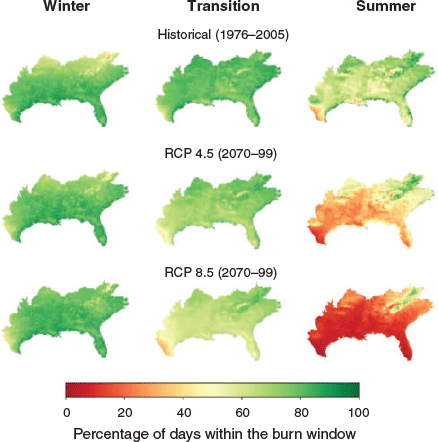
Our focal study region is the area encompassed by the Southeast Conservation Adaptation Strategy (SECAS: Southeast Conservation Adaptation Strategy 2018). SECAS was created by a collaborative network of federal and state conservation partners to create a vision for sustaining fish, wildlife and natural resources in changing future landscapes in 15 south-eastern states, the Virgin Islands and Puerto Rico. We included only areas of the SECAS footprint located within the contiguous US in our analyses. To provide insights into subregional changes in the availability of suitable burning days, we also examined future changes in greater detail for six land management units within the region: Big Cypress National Preserve (NPres), Uwharrie National Forest (NF), Land Between the Lakes National Recreation Area (NRA), Chattahoochee National Forest, Ouachita National Forest and Kisatchie National Forest (Fig. 1). These units are located within six different US EPA Level III ecoregions and were selected for their: (1) spatial coverage, in that they collectively comprise a range of different climate conditions and habitats within the region, and (2) management relevance, in that prescribed fire is an actively used management tool within each.

|
Prescribed burn windows
Initial thresholds for burn windows were defined using information from published manuals on prescribed burning in the South-east (e.g. Wade and Lunsford 1989; Waldrop and Goodrick 2012; Chiodi et al. 2018), guidelines provided for individual prescribed burn unit plans (e.g. Georgia Forestry Commission 2019) and input from regional fire managers. For relative humidity, we defined the burn window as days with relative humidity ≥30%. Below this value, fire intensities increase and fine dead fuels dry quickly. In many south-eastern states, a relative humidity <30% warrants a National Weather Service Red Flag Warning for potentially hazardous fire weather. As relative humidity increases, less fuel will combust, resulting in a lower fireline intensity and patchier burn, which may not be ideal for meeting some management objectives. However, rather than imposing an upper burn threshold, we simply use a lower boundary to exclude conditions under which burning is avoided to reduce the risk of losing containment.
Wind speed influences how fast a fire spreads and plays a role in shaping crown damage and smoke dispersion. Recommendations for wind speeds are complicated because speeds vary greatly within a canopy depending on factors such as understorey density and height and canopy tree density. In-stand winds of 0.4–1.3 m s−1 measured at eye level are preferred for most fuel and topographic situations, while desired minimum and maximum wind speeds at 6 m are ~2.5 and 8.9 m s−1 respectively, depending on canopy conditions (Wade and Lunsford 1989). Because fires are often set at even lower values to facilitate containment or to promote spread during winter understorey fires, we used slightly lower burn window thresholds of 2.25 to 8.0 m s−1.
Determining burn window thresholds for temperature was more difficult, in part because recommended air temperatures for prescribed fires depend on the season and objective of the fire. To establish a minimum temperature, we used regional guidelines for winter burning, which hold that temperatures should be above 0°C. Published guidelines for the upper temperature threshold, based on summer burning recommendations, are less precise. Waldrop and Goodrick (2012) state that if the objective is to control undesirable species (or if preserving the overstorey is not a concern), ambient growing season air temperatures should exceed 26°C. They do not, however, provide an upper threshold, and prescribed burning is regularly conducted at much hotter temperatures. States such as Georgia recommend that fires be conducted at ambient temperatures <30°C, but guidelines used by regional fire managers at Eglin Air Force Base and Apalachicola National Forest (both in northern Florida) cite a maximum threshold temperature of 35°C (J.K. Hiers, pers. comm.). We thus used the mid-point of these recommended maximum temperatures (32.5°C) as a starting value to represent prescription parameters used regionally. We then analysed regional burn permit data (described in the following section) to refine this temperature window as needed to reflect the temperatures experienced during the time of day when most managers would conduct burns.
Calculating daily availability of suitable burning conditions
We used two datasets to calculate, map and analyse spatiotemporal patterns of burn window availability under current conditions and explore potential changes due to projected anthropogenic climate change over the remainder of the century. For contemporary weather, we used the gridMET dataset (http://www.climatologylab.org/gridmet.html; accessed 6 May 2020), which blends spatial attributes of gridded climate data with temporal attributes from regional reanalysis of historical weather using climatically aided interpolation (Abatzoglou 2013). The resulting product is a high-resolution (~4 km) gridded dataset of surface meteorological conditions from 1979 to the present that has been validated and used in several studies (e.g. Abatzoglou and Kolden 2013), including those examining interactions among wildfire and climate change (e.g. Stavros et al. 2014; Abatzoglou and Williams 2016; Parks et al. 2016).
Future changes in burn window availability were explored using statistically downscaled GCM projections from the MACAv2-METDATA dataset (https://climate.northwestknowledge.net/MACA/; accessed 6 May 2020). This dataset downscales GCMs from the Coupled Model Intercomparison Project 5 (CMIP5: Taylor et al. 2012) utilising a modification of the Multivariate Adaptive Constructed Analogs (MACA) method with the gridMET observational dataset used as training data (see Abatzoglou and Brown 2012). MACA data, which are bias-corrected to and have the same spatial resolution as gridMET data, are part of the US Climate Resilience Toolkit and have been used in several studies examining potential impacts of future climate change (e.g. Sheehan et al. 2015). Model output was available for the CMIP5 historical simulation period (1950–2005) and scenarios representing different 21st century greenhouse gas emissions pathways (2006–99).
Although initial burn window thresholds were selected based on values from the literature and regional managers, we recognised the potential for a mismatch between: (1) the operational use of burn windows in relation to changing conditions throughout the day, and (2) our use of a select set of climate variables to calculate current availability of, and project future frequencies of, suitable burning conditions. The available temperature variables in long-term gridded climate datasets such as gridMET and the downscaled climate model projections in MACAv2-METDATA are typically limited to daily maxima and minima, and across such a wide region, a 32.5°C upper temperature threshold may be less applicable in some locations. Moreover, managers could make use of their own heuristics when deciding whether to conduct a burn, such as using the expected temperature at the time of ignition (typically between 1000 and 1300 hours).
To address these potential discrepancies and ensure that the set of meteorological variables used to project burn window conditions was representative of the actual conditions used by managers, we analysed daily meteorological conditions coincident with burn permits from Florida and Georgia over an 11-year period from 2006 to 2016 (see Supplementary Material Text S1 for details on this dataset). These permitting records were readily available, consistently archived and representative of the range of habitat types in the study area. Prior to analysis, the site-specific Florida permit data were aggregated to the county level to match the reporting resolution of the Georgia permit data. We removed pile burn permits to focus solely on broadcast fires, which yielded a dataset containing 241 033 burn permit records. If our a priori criteria based on the daily extremes of temperature and relative humidity were not highly correlated with the actual prescribed burn criteria used by managers or if the variables inadequately captured surface meteorology at the time of the fires, we would expect a significant number of permits to fall on days with conditions outside the climate variable windows that are based on daily extrema.
We first extracted five meteorological variables from the gridMET dataset for the date of each fire in the permit data: minimum and maximum relative humidity, minimum and maximum temperature, and mean wind speed. Because the permits were aggregated to the county level, values of each variable were averaged for all cells within a county using the Zonal Statistics tool in ArcGIS ver. 10.4 as an approximation for the weather conditions on burning days. We then calculated basic descriptive statistics and generated histograms of the frequency of meteorological conditions on days when prescribed fires were permitted.
An assessment of the permit data against daily temperature and relative humidity extremes indicated that a significant portion of permitted days fell outside burn windows that were defined based on the gridMET estimated minimum and maximum daily temperatures and relative humidity. The permit data also revealed that most ignition times occurred between 1000 and 1300 hours; in contrast, the daily minimum temperature (and maximum relative humidity) and daily maximum temperature (and minimum relative humidity) in South-eastern forests typically occur at ~0500–0600 and 1500–1600 hours respectively. We therefore developed estimates of hourly temperature and relative humidity for times of day that better reflected conditions anticipated by managers conducting the prescribed fire. We were especially interested in estimating local noon (1200 hours) temperature and relative humidity as this time coincides (approximately) with the midpoint of most prescribed fires.
Methods for estimating hourly temperature and relative humidity from daily extremes widely in their complexity and required inputs (e.g. Kimball and Bellamy 1986; Reicosky et al. 1989; Ephrath et al. 1996). Some methods were too computationally intensive for the spatial extent of our analyses or required data that were not available for the datasets that we employed, including the MACA data. We thus chose to estimate the local noon temperature using a method that assumes that temperature variation is driven by solar irradiance and provides a smooth transition from minimum to maximum air daily temperature (Campbell 1985):
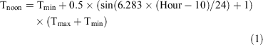
where Tnoon is the estimated temperature at noon, Tmin and Tmax are the daily minimum and maximum temperatures, and Hour is the time to be approximated (set to 12, for noon). We also estimated values for the noontime relative humidity:
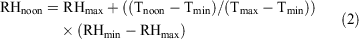
where RHnoon is the estimated relative humidity at noon, RHmin and RHmax are the daily minimum and maximum relative humidities, and Tmin, Tmax and Tnoon are the daily minimum, maximum and noon temperatures as per Eqn 1 (Waichler and Wigmosta 2003). This equation has been shown to perform well in comparison with other approaches when values for daily maximum and minimum relative humidity were available (Bregaglio et al. 2010).
Burn windows based on estimated noontime temperature and relative humidity better captured the meteorological conditions that occurred during regional prescribed fire activities (Table 1; Fig. 2). More than 97% of the days on which permits were requested for prescribed fires in Florida and Georgia took place within the selected burn window thresholds as approximated by daily noon temperature (Tnoon) and relative humidity (RHnoon). In contrast, the use of the daily extrema (daily minimum and maximum temperature, minimum relative humidity) to define the burn window only captured between 74.8% and 86.9% of the permitted days (Table 1). We did not estimate noontime wind speed, but the majority (84.1%) of permitted days fell within the burn window for daily average wind speeds, with 15.6% of days having mean wind speeds that fell below the lower wind speed threshold and only 0.3% of days having wind speeds above the recommended upper threshold.

|

|
The upper temperature threshold (32.5°C at 1200 hours), in particular, appears to represent a meaningful management threshold for conducting prescribed fires. Fewer than 2% of permits were requested under conditions warmer than this threshold, and those fires accounted for far less than 1% of all permitted burn area (Fig. 3). Further, the size of the largest permitted fires dropped precipitously beyond this threshold, which could indicate a step increase in the perceived riskiness of continuing to conduct mission-critical burns at high temperatures. Operationally, it is worth noting that an upper threshold of 32.5°C at noon corresponded to burn days with maximum temperatures of ~36–37°C. Such days would already be a source of major heat stress, with most ignitions occurring before noon to avoid unnecessary risk to personnel. This lends further support for the use of this threshold given its correspondence to the fire permit records.

|
Considering these results, subsequent analyses were based on values of three meteorological variables that were calculated for each 4-km pixel in both the gridMET and MACAv2-METDATA datasets: 1200 hours temperature, 1200 hours relative humidity and daily mean wind speed.
Projecting future changes in the availability of suitable burning conditions
Changes in the number of days meeting burn window conditions under future climate scenarios were analysed using the downscaled MACA-derived GCM projections. Because projections based on output from any single GCM would severely truncate the estimated range of potential future climatic conditions, we obtained and analysed data from 18 GCMs that had daily outputs for all of the weather variables of interest (temperature, relative humidity, wind speed): BCC_CSM1.1, BCC_CSM1.1(m), BNU-ESM, CanESM2, CNRM-CM5, CSIRO-Mk3–6-0, GFDL-ESM2G, GFDL-ESM2M, HadGEM2-CC, HadGEM2-ES, INMCM, IPSL-CM5A-LR, IPSL-CM5A-MR, IPSL-CM5B-LR, MIROC5, MIROC-ESM, MIROC-ESM-CHEM and MRI-CGCM3 (see Supplementary Material Table S2.1 for the full names of GCMs used in this study). For each GCM, we used the downscaled climate model output for two greenhouse gas emissions scenarios or Representative Concentration Pathways (RCPs): RCP 8.5, which represents a higher emissions pathway and often serves as a scenario that does not include any specific emissions reduction target, and RCP 4.5, a lower emissions scenario that assumes reductions that stabilise emissions, atmospheric greenhouse gas concentrations and radiative forcing of the climate system. Comparing the results against multiple scenarios is important because the uncertainty associated with future emissions due to human activities begins to dominate the total climate model projection uncertainty in the decades after the middle of the 21st century (Hawkins and Sutton 2009).
We produced estimates of 1200 hours temperature and relative humidity for the MACA-derived GCM projections using the procedure described above for analysing the GridMet data, and classified each day from 1950 to 2099 as suitable or unsuitable for prescribed burning based on whether or not it met the burn window criteria for all three climate variables. The resulting number of suitable burning days per month were calculated for each grid cell in the study area. Because changes in the percentage of days meeting acceptable burn conditions might be expected to exhibit seasonal variation, we also aggregated the monthly values based on the downscaled GCMs into three seasons corresponding to common prescribed fire management periods: (1) the ‘winter’ burning season (January and February), (2) the ‘summer’ burning season (June and July), and (3) a ‘transitional’ spring burning season (March, April and May).
Results
Regional changes in seasonal burn window availability
Burn window availability in the historical period (1976–2005) as calculated from the multimodel mean for all 18 downscaled GCMs showed suitable conditions throughout the region during the winter burn season and widespread opportunities during the summer months (Fig. 4, top row). However, the frequency of suitable burning days was projected to decrease substantially during the warm-season months across much of the region under future climates, with the percentage of suitable days dropping from 64.9 to 40.6% under the RCP 4.5 scenario and 21.9% under the RCP 8.5 scenario (Fig. 4, right column). Areas in the south-western part of the study region would experience especially severe declines in which fewer than 10–15% of summer days would remain viable for conducting prescribed fires. Changes in climate associated with the RCP 4.5 and RCP 8.5 scenarios generally resulted in few changes in the number of suitable days during winter, with some areas where burning conditions are currently limited by cold winter temperatures (northern locations and higher elevations) even experiencing slight increases (Fig. 4, left column). Overall, the percentage of suitable burn days in the winter season based on the multimodel mean is projected to increase 1.5% under the RCP 4.5 scenario by the end of the 21st century compared with historical conditions (from 76.6 to 78.2% of days) and 3.0% (76.6 to 79.6%) under the RCP 8.5 scenario.
|
Results for the region-wide seasonal changes in burn window availability were consistent across the downscaled GCMs (Supplementary Material Table S2.2). For the winter burn season, small increases in the percentage of suitable days are projected for 15 of the 18 GCMs under RCP 4.5 (mean: +2.0%; range: –1.5 to +5.8%) and 17 of the 18 GCMs under RCP 8.5 (mean: +3.8%; range: –1.7 to +7.9%). For the summer season, the percentage of suitable days dropped under all GCM projections (often substantially), but there was greater variation in the projected impacts than for winter for both RCP 4.5 (mean: –37.5%; range: –13.8 to –53.1%) and RCP 8.5 (mean: –66.3%; range: –37.0 to –84.6%) scenarios. The GCM range of region-wide projected changes during the transitional spring month showed small decreases in burn-day availability under RCP 4.5 (mean: –4.0%; range: –5.9 to –0.6%) but was more pronounced under RCP 8.5 (mean: –10.5%; range: –17.0 to –5.6%).
We explored the challenge confronting managers with respect to how many fewer days would be expected to experience temperatures within the original safe-operating temperature range compared with the historical period by using a bootstrapping procedure to estimate the distribution of projected noontime temperatures on days that historically were favourable for burning (Fig. 5). For each GCM, we repeatedly sampled (n = 250) 1-year blocks of Julian dates over the period 2080–99 that corresponded to the same historical Julian dates for which burn permits were issued. The top two panels display histograms for the GCM showing the least (right panel; INMCM under the RCP4.5 scenario) and most (left panel; HadGEM2-ES under the RCP8.5 scenario) amount of warming while the bottom histogram is the same as that shown in Fig. 2b. The HadGEM2-ES model results indicate that the number of original permitted days expected to be above the 32.5°C threshold would rise from 2.5% for the 2006–16 period to 28%, a more than 10-fold increase in out-of-prescription days. In the lower panel, we illustrate these results by overlaying each GCM’s 32.5°C threshold that corresponds to the same frequency of days under historical conditions on the original histogram. For example, the results for the HadGEM2-ES model under RCP8.5 are depicted as brown vertical lines at 26.9 and –4.6°C, meaning that the frequency of days in the future falling between 0 and 32.5°C is equivalent to the frequency of days during 2006–16 that experienced noontime temperatures between –4.6 and 26.9°C. Under both emissions scenarios, managers would face new constraints and reduced opportunities to burn on days that currently fall within the safe operating conditions for conducting prescribed fires.

|
Changes in individual management units
For the six focal management units, declines in suitable burn days through 2099 under RCP 8.5 are driven by projected increases in noontime temperature, particularly in the warm-season months (Fig. 6). Conversely, relative humidity and wind speed under RCP 8.5 were not projected to differ noticeably from the historical record. For the two southernmost units (Big Cypress NPres and Kisatchie NF), the number of suitable burn days was projected to decline from ~15 to fewer than 2–6 per month from May through August as temperatures increased. As a result, the summer burning season was virtually eliminated, with the multimodel mean showing only 5–10% of days meeting the burn window criteria. This loss of summer burn days was again in contrast to the winter burning season, where most days remained within the temperature threshold and the overall winter burn season was not projected to change noticeably. The management units at higher elevations (Chattahoochee NF, Ouachita NF) or higher latitudes (Uwharrie NF, Land Between the Lakes NRA) showed less drastic projected changes during the warmer months but were nonetheless still projected to experience declines in the percentage of days meeting the burn window criteria.

|
The annual time series of observed and projected percentages of suitable burn days for each management unit under the RCP8.5 scenario are shown in Fig. 7. The observed burn window suitability based on the gridMET dataset for 1987–2017 (the red line in Fig. 7) showed much greater interannual variability than the ensemble mean (black dotted line), but nearly all of the values fell within the range of the GCM ensemble (shaded grey areas). The range of projected burn window responses was generally largest during the summer burn months compared with the winter and transition seasons. A notable exception to this is seen towards the end of the century, where the range of projected changes in suitable summer burn days at the warmer sites (Big Cypress NPres and Kisatchie NF) actually declines simply because some models project that summer months will no longer have any suitable days to conduct prescribed fires. For the winter season (and the transition season at some sites), the range is comparatively small, with most values falling 5–15% above or below the multimodel ensemble mean.

|
Unlike the lower-elevation Coastal Plain sites, the percentage of suitable burning days during the winter burning season at Uwharrie NF and Chattahoochee NF was projected to increase slightly (<5%) as warming temperatures brought more suitable days for prescribed fire. Similarly, warming winter conditions led to a greater frequency of suitable burning days at the inland Ouachita NF and Land Between the Lakes NRA sites, but the number of suitable days was lower than for the more eastern units owing to more frequent penetration of cold air masses. When coupled with the more restrictive summer conditions, the result was a narrower set of months for burning centred in spring (February–April) and late fall (autumn) (November).
Throughout our analyses, the results using data for the RCP 4.5 scenario are qualitatively similar to those for RCP 8.5, except there is less projected warming over the 21st century, which increases the availability of burn days in the warm-season months (see Supplementary Material Table S2.2, Figs S2.1, S2.2).
Discussion
Fire management in a time of rapidly changing climate
Our analysis of a large dataset of prescribed fire permits confirmed that a simple and static set of meteorological criteria can effectively characterise the vast number of burning activities conducted by managers in the south-eastern US. When coupled with projections from a suite of 18 statistically downscaled climate models under two greenhouse gas forcing scenarios, the results depict a future in which there would be substantial reductions in late spring and summer opportunities for prescribed fire in the region. These lost opportunities are driven by elevated maximum temperatures causing high-heat days that currently are viewed as unsuitable or too risky for conducting burns. Prescribed fire is one of the most important strategies available to forest managers to reduce wildfire risk and achieve ecological objectives in the US and globally, but current practices will be challenged by projected warming trends with both practical and ecological consequences.
In addition to the dramatic declines in summer burn opportunities, the projected changes in climate would lead to increasing variance and decreasing reliability in late spring and early fall burn windows under the current criteria. This change would constitute an important potential impact to management because of the widespread use of prescribed fire in a region where current climatic conditions generally support near year-round burning. There is a strong consensus across climate models and emission scenarios that significant region-wide declines in burning opportunities would occur beginning around the middle of the century, driven primarily by rising temperatures during the summer and spring months. A notable caveat to these results is that many (but not all) of the GCMs show early-onset declines in suitable burn days that are not borne out by the historical observations, particularly in the summer months. If the regional climates simulated by some ensemble members are biased towards conditions that are too warm and dry (or warming and drying too rapidly compared with reality), then the expected timeframe to experience significant reductions in suitable burn days would be delayed.
A reduction in opportunities for prescribed burning would have significant impacts on risks associated with wildfire in a region that can experience high temperatures and a rapid build-up of fuels (Stambaugh et al. 2009). Prescribed burning programs are an effective tool for lessening wildfire risk, with prescribed fires reducing both the number and impact of wildfires for up to 2 years post burn (Addington et al. 2015). However, the application of prescribed fire is sensitive to seasonal and interannual droughts, which can reduce their spatial extent (Nowell et al. 2018) and shorten the efficacy of risk reduction (Addington et al. 2015). Future changes in relative humidity were not projected to have a substantial effect on burn window availability and timing (Fig. 6, Fig. S2.1), but projections of future precipitation are more uncertain (Easterling et al. 2017). Although not directly considered here, there is a non-trivial risk that climate change could result in more frequent or intense droughts, mainly through increased drying as evapotranspiration rates increase (Wehner et al. 2017). In particular, most of the western and southern portions of the study region are projected to experience drier conditions in spring and summer. Virtually any increase in wildfire activities (throughout the US) would further divert management resources during the summer months and shoulder seasons, which are already projected to lose burn windows in this study. In addition to the increased risk that accompanies lost opportunities for fuel reduction through prescribed burning activities, such a scenario would increase wildfire risk by promoting meteorological conditions favourable for the ignition and spread of the largest wildfires (Liu et al. 2014; Prestemon et al. 2016; Terando et al. 2017), resulting in more forests being exposed to higher-severity wildfire events associated with extreme fire weather (Prichard et al. 2017; Krofcheck et al. 2019).
Beyond increased wildfire risks due to drier conditions and declining fuel moisture, rising warm-season temperatures will likely add to the complexity of maintaining air quality standards during prescribed fires. Smoke management remains a primary impediment to the implementation of prescribed fire in the region (Hu et al. 2008), and ozone production in summer months already restricts prescribed fire activities adjacent to metropolitan areas (Liu et al. 2009). The high sun angle and elevated temperatures experienced during much of the spring through fall seasons in the South-east facilitate ozone formation from volatile organic compounds found in smoke, particularly in the region’s pine forests (Akagi et al. 2013). CMIP5 projections of warm-season relative humidity changes by the end of the century show only modest decreases for the region (average decreases of 1.8 and 3.7% for RCP4.5 and RCP8.5 respectively), suggesting that the projected warming would still occur within a very humid environment. The attendant stagnant air masses may further restrict prescribed burning through concerns over emissions and non-attainment of Clean Air Act regulations (Odman et al. 2009).
A reduction in the availability and reliability of warm-season burning opportunities would have significant consequences for many native ecosystems in the South-east given the critical role that fire plays in the conservation, management and restoration of biodiversity and ecological resilience in these systems (e.g. Kirkman and Jack 2017). Decisions about how and when to apply prescribed fire in the US have often addressed replicating the pattern of fires ignited by lightning or preindustrial humans under the assumption that it will best promote native species in fire‐prone regions (in the sense of the historical fire regime concept; Freeman et al. 2017). Prescribed fire activities in the South-east for much of the 20th century have been concentrated in the winter months, largely owing to ease of fire control, but land managers have also used warm-season months to expand burning opportunities and meet ecological objectives that are not possible through the use of winter and early spring burns. The projected loss of burn days in late spring and summer would further curtail efforts to use summer season burns (which were common under many historic fire regimes; Platt et al. 2015) to promote certain components of biodiversity and forest resilience (Platt et al. 1988; Bishop and Haas 2005). Moreover, projected increases in the variance of days falling within the burn window during spring, which accounts for a large percentage of burned area in the region (Nowell et al. 2018), would represent a significant challenge to fire managers’ ability to reliably achieve ecological objectives.
Subregional variation in climate change effects
Our analyses indicated consistent region-wide changes in the frequency of suitable burn days over the remainder of the 21st century, but there was substantial subregional spatial variation in the projected responses for both summer and winter burn seasons. During the summer, decreases exceeding 50% of the days currently falling within the burn window were widespread under RCP 8.5 and common under RCP 4.5. Summer declines were greatest in the southern and south-western portions of the region, where the length of the burning season was often already limited (Fig. 4). The south-western portion of the study area was also projected to experience modest decreases in suitable burning conditions during winter that, when coupled with the virtual elimination of a summer burning season, would represent a significant challenge to the use of prescribed fires as a management tool.
Individual landscapes, represented here by the six management units that were examined in greater detail, showed nuanced effects on prescribed burn windows over time and between scenarios. The Coastal Plain sites (Big Cypress NPres and Kisatchie NF) were projected to lose nearly all summer burn days by 2099 under the RCP 8.5 scenario (Figs 6 and 7). Summer reductions were slightly less drastic in more inland areas of the North Carolina Piedmont (Uwharrie NF), US Interior Highlands (Ouachita NF) and US Interior Plateau (Land Between the Lakes NRA); these are, however, locations where it is already less common to use summer prescribed fires to manage hardwood forests, potentially mitigating some losses of opportunity. Chattahoochee NF, which is located at the southernmost extent of the Blue Ridge Mountains, is buffered by its elevation and showed the smallest decline in number of summer days within burn prescription.
Potential adaptation strategies
Attempts to maintain seasonal burn activities by widening prescription windows to include hotter temperatures (Tnoon > 32.5°C) are likely to result in both altered ecological fire effects and adverse impacts to personnel. With rising temperatures in the ranges projected, vapour pressure deficits would be expected to rapidly increase, affecting plant productivity, phenology and survival (e.g. Hatfield and Prueger 2015). This rise in vapour pressure deficit with increasing temperature would occur despite model predictions of little change in relative humidity under either scenario. It is unclear how the increases in relative plant stress, particularly in summer months, will alter post-fire effects in a region where vegetation is adaptive to frequent fire, particularly given that increased mortality with drought stress is well documented in the region and other frequently burned ecosystems (McDowell and Allen 2015; O’Brien et al. 2018).
More practically, relaxing the temperature criteria is likely to dramatically increase the risk of heat stress for fire crews in the region as the increased warm season temperatures are projected to still co-occur with high levels of relative humidity (Carter et al. 2018). Domitrovich and Sharkey (2010), for example, suggest that the risk of heat-related illness for wildland firefighters increases at temperatures exceeding ~32.5°C when relative humidity is above 30%. Thus, even if fire managers were willing to accept the potential ecological consequences of relaxing the maximum temperature threshold, concerns over risks to personnel might prevent (or at least limit) such a decision.
Seasonal and diurnal adjustments to the timing of prescribed fires may allow managers to continue to meet their objectives while avoiding some of the risk associated with expanded temperature windows. In five out of the six management units, ~75% of days during the transitional burn season (spring months) are projected to remain within the prescription criteria regardless of the emissions scenario. In the fall months (September, October, November), losses of suitable burn days are projected to be larger, particularly under the RCP 8.5 scenario. Nevertheless, at least 50% of days are projected to remain within prescription at five sites for the RCP 8.5 scenario (Fig. 6), while all sites remain above 50% suitable days for the RCP 4.5 scenario (Fig. S2.1). Shifting burn windows to the fall may allow managers to compensate for the loss of summer burn days for risk management objectives. In contrast, the winter and spring transitional burn seasons are both already heavily used to accomplish the majority of burning in some areas of the region. It therefore seems unlikely that significant additional utilisation of those burn seasons would occur unless weekend burning becomes more common.
Many managers use diurnal patterns of fuel moisture to accomplish burn objectives, but night-time burning has been heavily regulated over the past several decades owing to air quality concerns. Earlier daytime starts to conduct fires within prescription may also be present in our analysis of current burn windows. The fact that noontime temperatures and relative humidity (rather than daily extremes) appear to more accurately characterise periods of prescribed burning suggests that managers already take advantage of small windows of opportunity with favourable conditions. More aggressive exploitation of morning ignition times, non-traditional burning days (e.g. weekends and holidays), or technological assistance (e.g. unmanned aerial vehicles) may be needed to allow managers to maintain prescription windows and accomplish societal objectives in a warmer future.
Summary and conclusions
To assess the impact of climate change on prescribed fires, we leveraged a decade of fire permit records from two south-eastern states to identify prescribed burn windows for commonly recommended environmental variables. Using a high-resolution, statistically downscaled climate model dataset, we projected, mapped and analysed potential changes in prescribed fire opportunities across the south-eastern US, a region that conducts more than 3 million ha of prescribed fire annually. Our results point towards a future for prescribed fire opportunities in which managers and decision-makers will likely have to confront difficult trade-offs and greater constraints on their burn programs. There was a consensus across GCMs and scenarios that continuing current practices would result in sharp declines in burn opportunities over time, with the greatest projected reductions in prescribed fire opportunities concentrated in the summer months regardless of the emission scenario. The consequences of missed burn opportunities may even be larger than those expected based on our model projections because a sharp reduction in suitable warm-season (i.e. spring through fall) days implies that the length of time before the next burn opportunity arises could also increase. Adapting to these changes would likely require managers to consider a range of actions and strategies to maintain current levels of prescribed fire. Adaptation strategies such as changing the timing of burns (either seasonally, weekly, or daily) or relaxing burn window criteria (Chiodi et al. 2019) could result in maintaining opportunities, but not without their own set of trade-offs and risks with respect to public health, personnel safety, biodiversity impacts, ecological restoration and air quality objectives. Given the spatial and seasonal variation in projected changes to prescribed fire opportunities, successful adaptation strategies will likely be characterised by reliance on local innovations. Without such changes, the projected climatic changes would likely result in significant reductions in prescribed fire activities in this region that is critically dependent on managed fire regimes for ecosystem resilience.
Conflicts of interest
The authors declare no conflicts of interest.
Acknowledgments
The authors wish to thank two anonymous reviewers and the Associate Editor for comments that helped us to improve the focus and quality of this paper. This work was supported by the US Geological Survey Southeast Climate Adaptation Science Center (grant no. G15AP00162). Any use of trade, firm, or product names is for descriptive purposes only and does not imply endorsement by the US Government.
References
Abatzoglou JT (2013) Development of gridded surface meteorological data for ecological applications and modelling. International Journal of Climatology 33, 121–131.| Development of gridded surface meteorological data for ecological applications and modelling.Crossref | GoogleScholarGoogle Scholar |
Abatzoglou JT, Brown TJ (2012) A comparison of statistical downscaling methods suited for wildfire applications. International Journal of Climatology 32, 772–780.
| A comparison of statistical downscaling methods suited for wildfire applications.Crossref | GoogleScholarGoogle Scholar |
Abatzoglou JT, Kolden CA (2013) Relationships between climate and macroscale area burned in the western United States. International Journal of Wildland Fire 22, 1003–1020.
| Relationships between climate and macroscale area burned in the western United States.Crossref | GoogleScholarGoogle Scholar |
Abatzoglou JT, Williams AP (2016) The impact of anthropogenic climate change on wildfire across western US forests. Proceedings of the National Academy of Sciences of the United States of America 113, 11770–11775.
| The impact of anthropogenic climate change on wildfire across western US forests.Crossref | GoogleScholarGoogle Scholar | 27791053PubMed |
Addington RN, Hudson SJ, Hiers JK, Hurteau MD, Hutcherson TF, Matusick G, Parker JM (2015) Relationships among wildfire, prescribed fire, and drought in a fire-prone landscape in the south-eastern United States. International Journal of Wildland Fire 24, 778–783.
| Relationships among wildfire, prescribed fire, and drought in a fire-prone landscape in the south-eastern United States.Crossref | GoogleScholarGoogle Scholar |
Akagi SK, Yokelson RJ, Burling IR, Meinardi S, Simpson I, Blake DR, McMeeking GR, Sullivan A, Lee T, Kreidenweis S, Urbanski S (2013) Measurements of reactive trace gases and variable O3 formation rates in some South Carolina biomass burning plumes. Atmospheric Chemistry and Physics 13, 1141–1165.
| Measurements of reactive trace gases and variable O3 formation rates in some South Carolina biomass burning plumes.Crossref | GoogleScholarGoogle Scholar |
Balch JK, Bradley BA, Abatzoglou JT, Nagy RC, Fusco EJ, Mahood AL (2017) Human-started wildfires expand the fire niche across the United States. Proceedings of the National Academy of Sciences of the United States of America 114, 2946–2951.
| Human-started wildfires expand the fire niche across the United States.Crossref | GoogleScholarGoogle Scholar | 28242690PubMed |
Bishop DC, Haas CA (2005) Burning trends and potential negative effects of suppressing wetland fires on flatwoods salamanders. Natural Areas Journal 25, 290–294.
Bregaglio S, Donatelli M, Confalonieri R, Acutis M, Orlandini S (2010) An integrated evaluation of thirteen modelling solutions for the generation of hourly values of air relative humidity. Theoretical and Applied Climatology 102, 429–438.
| An integrated evaluation of thirteen modelling solutions for the generation of hourly values of air relative humidity.Crossref | GoogleScholarGoogle Scholar |
Budd GM (2001) How do wildland firefighters cope? Physiological and behavioural temperature regulation in men suppressing Australian summer bushfires with hand tools. Journal of Thermal Biology 26, 381–386.
| How do wildland firefighters cope? Physiological and behavioural temperature regulation in men suppressing Australian summer bushfires with hand tools.Crossref | GoogleScholarGoogle Scholar |
Campbell GS (1985) ‘Soil physics with BASIC: transport models for soil–plant systems.’ (Elsevier: Amsterdam, the Netherlands).
Carter L, Terando A, Dow K, Hiers JK, Kunkel KE, Lascurain A, Marcy D, Osland M, Schramm P (2018) Southeast. In ‘Impacts, risks, and adaptation in the United States: fourth national climate assessment, Vol. II’. (Eds DR Reidmiller, CW Avery, DR Easterling, KE Kunkel, KLM Lewis, TK Maycock, BC Stewart) pp. 743–808. (US Global Change Research Program: Washington, DC, USA).
Chiodi AM, Larkin NS, Varner JM (2018) An analysis of south-eastern US prescribed burn weather windows: seasonal variability and El Nino associations. International Journal of Wildland Fire 27, 176–189.
| An analysis of south-eastern US prescribed burn weather windows: seasonal variability and El Nino associations.Crossref | GoogleScholarGoogle Scholar |
Chiodi AM, Larkin NK, Varner JM, Hiers JK (2019) Sensitivity of prescribed burn weather windows to atmospheric dispersion parameters over south-eastern USA. International Journal of Wildland Fire 28, 589–600.
| Sensitivity of prescribed burn weather windows to atmospheric dispersion parameters over south-eastern USA.Crossref | GoogleScholarGoogle Scholar |
Clarke H, Tran B, Boer MM, Price O, Kenny B, Bradstock R (2019) Climate change effects on the frequency, seasonality and interannual variability of suitable prescribed burning weather conditions in south-eastern Australia. Agricultural and Forest Meteorology 271, 148–157.
| Climate change effects on the frequency, seasonality and interannual variability of suitable prescribed burning weather conditions in south-eastern Australia.Crossref | GoogleScholarGoogle Scholar |
Costanza J, Terando A, McKerrow AJ, Collazo J (2015) Modeling climate change, urbanization, and fire effects on Pinus palustris ecosystems in the south-eastern US. Journal of Environmental Management 151, 186–199.
| Modeling climate change, urbanization, and fire effects on Pinus palustris ecosystems in the south-eastern US.Crossref | GoogleScholarGoogle Scholar | 25576696PubMed |
Domitrovich J, Sharkey B (2010) Heat illness basics for wildland firefighters. USDA Forest Service Missoula Technology and Development Center, Tech Tip 1051–2316P–MTDC. (Missoula, MT, USA).
Easterling DR, Kunkel KE, Arnold JR, Knutson T, LeGrande AN, Leung LR, Vose RS, Waliser DE, Wehner MF (2017) Precipitation change in the United States. In ‘Climate science special report: fourth national climate assessment, Vol. I’. (Eds DJ Wuebbles, DW Fahey, KA Hibbard, DJ Dokken, BC Stewart, TK Maycock) pp. 207–230. (US Global Change Research Program: Washington, DC, USA).
Ephrath JE, Goudriaan J, Marani A (1996) Modelling diurnal patterns of air temperatures, radiation, wind speed and relative humidity by equations for daily characteristics. Agricultural Systems 51, 377–393.
| Modelling diurnal patterns of air temperatures, radiation, wind speed and relative humidity by equations for daily characteristics.Crossref | GoogleScholarGoogle Scholar |
Fosberg MA, Deeming JE (1971) Derivation of the 1- and 10-hour timelag fuel moisture calculations for fire-danger rating. USDA Forest Service, Rocky Mountain Forest and Range Experiment Station, Research Note RM-RN-207. (Fort Collins, CO, USA).
Fowler C, Konopik E (2007) The history of fire in the southern United States. Human Ecology Review 14, 165–176.
Freeman J, Kobziar L, White Rose E, Cropper W (2017) A critical evaluation of the historical fire regime concept in conservation. Conservation Biology 31, 976–985.
| A critical evaluation of the historical fire regime concept in conservation.Crossref | GoogleScholarGoogle Scholar | 28370371PubMed |
Georgia Forestry Commission (2019) Prescribed burn plan. Available at https://gatrees.org/resources/prescribed-burn-plan/ [Verified 10 April 2020]
Guyette RP, Thompson FR, Whittier J, Stambaugh MC, Dey DC (2014) Future fire probability modeling with climate change data and physical chemistry. Forest Science 60, 862–870.
| Future fire probability modeling with climate change data and physical chemistry.Crossref | GoogleScholarGoogle Scholar |
Hatfield JL, Prueger JH (2015) Temperature extremes: effect on plant growth and development. Weather and Climate Extremes 10, 4–10.
| Temperature extremes: effect on plant growth and development.Crossref | GoogleScholarGoogle Scholar |
Hawkins E, Sutton R (2009) The potential to narrow uncertainty in regional climate predictions. Bulletin of the American Meteorological Society 90, 1095–1107.
| The potential to narrow uncertainty in regional climate predictions.Crossref | GoogleScholarGoogle Scholar |
Hiers JK, Laine SC, Bachant JJ, Furman JH, Greene WW, Compton V (2003) Simple spatial modeling tool for prioritizing prescribed burning activities at the landscape scale. Conservation Biology 17, 1571–1578.
| Simple spatial modeling tool for prioritizing prescribed burning activities at the landscape scale.Crossref | GoogleScholarGoogle Scholar |
Hiers JK, O’Brien JJ, Varner JM, Butler BW, Dickinson M, Furman J, Gallagher M, Godwin D, Goodrick SL, Hood SM, Hudak A, Kobziar LN, Linn R, Loudermilk EL, McCaffrey S, Robertson K, Rowell EM, Skowronski N, Watts AC, Yedinak KM (2020) Prescribed fire science: understanding the behavior, effects and challenges of fires we use. Fire Ecology 16, 11
| Prescribed fire science: understanding the behavior, effects and challenges of fires we use.Crossref | GoogleScholarGoogle Scholar |
Hu Y, Odman MT, Chang ME, Jackson W, Lee S, Edgerton ES, Baumann K, Russell AG (2008) Simulation of air quality impacts from prescribed fires on an urban area. Environmental Science & Technology 42, 3676–3682.
| Simulation of air quality impacts from prescribed fires on an urban area.Crossref | GoogleScholarGoogle Scholar |
Kimball BA, Bellamy LA (1986) Generation of diurnal solar radiation, temperature, and humidity patterns. Energia na Agricultura 5, 185–197.
| Generation of diurnal solar radiation, temperature, and humidity patterns.Crossref | GoogleScholarGoogle Scholar |
Kirkman LK, Jack SB (Eds) (2017) ‘Ecological restoration and management of longleaf pine forests.’ (CRC Press: Boca Raton, FL, USA).
Krofcheck DJ, Loudermilk EL, Hiers JK, Scheller RM, Hurteau MD (2019) The effects of management on long-term carbon stability in a south-eastern US forest matrix under extreme fire weather. Ecosphere 10, e02631
| The effects of management on long-term carbon stability in a south-eastern US forest matrix under extreme fire weather.Crossref | GoogleScholarGoogle Scholar |
Lafon CW (2010) Fire in the American South: vegetation, impacts, history, and climatic relations. Geography Compass 4, 919–944.
| Fire in the American South: vegetation, impacts, history, and climatic relations.Crossref | GoogleScholarGoogle Scholar |
Liu Y, Goodrick SL, Achtemeier G, Jackson WA, Qu JJ, Wang W (2009) Smoke incursions into urban areas: simulation of a Georgia prescribed burn. International Journal of Wildland Fire 18, 336–348.
| Smoke incursions into urban areas: simulation of a Georgia prescribed burn.Crossref | GoogleScholarGoogle Scholar |
Liu Y, Goodrick SL, Stanturf JA (2013) Future US wildfire potential trends projected using a dynamically downscaled climate change scenario. Forest Ecology and Management 294, 120–135.
| Future US wildfire potential trends projected using a dynamically downscaled climate change scenario.Crossref | GoogleScholarGoogle Scholar |
Liu Y, Goodrick S, Heilman W (2014) Wildland fire emissions, carbon, and climate: wildfire–climate interactions. Forest Ecology and Management 317, 80–96.
| Wildland fire emissions, carbon, and climate: wildfire–climate interactions.Crossref | GoogleScholarGoogle Scholar |
McDowell NG, Allen CD (2015) Darcy’s law predicts widespread forest mortality under climate warming. Nature Climate Change 5, 669–672.
| Darcy’s law predicts widespread forest mortality under climate warming.Crossref | GoogleScholarGoogle Scholar |
McKenzie D, Littell JS (2017) Climate change and the eco-hydrology of fire: will area burned increase in a warming western USA? Ecological Applications 27, 26–36.
| Climate change and the eco-hydrology of fire: will area burned increase in a warming western USA?Crossref | GoogleScholarGoogle Scholar | 28001335PubMed |
Melvin MA (2015) National prescribed fire use survey report. Coalition of Prescribed Fire Councils Technical Report 02–15. (Washington, DC).
Mitchell RJ, Liu Y, O’Brien JJ, Elliott KJ, Starr G, Miniat CF, Hiers JK (2014) Future climate and fire interactions in the south-eastern region of the United States. Forest Ecology and Management 327, 316–326.
| Future climate and fire interactions in the south-eastern region of the United States.Crossref | GoogleScholarGoogle Scholar |
National Academies of Sciences, Engineering, and Medicine (2017) ‘A century of wildland fire research: contributions to long-term approaches for wildland fire management. Proceedings of a workshop, 27 March 2017, Washington, DC.’ (The National Academies Press: Washington, DC, USA)
Nowell HK, Holmes CD, Robertson K, Teske C, Hiers JK (2018) A new picture of open fire extent, variability, and drought interaction from Florida government records. Geophysical Research Letters 45, 7874–7884.
| A new picture of open fire extent, variability, and drought interaction from Florida government records.Crossref | GoogleScholarGoogle Scholar | 31031448PubMed |
National Wildfire Coordinating Group (2017a) Interagency prescribed fire planning and implementation procedures guide. National Wildfire Coordinating Group, Report PMS 484. (Boise, ID, USA).
National Wildfire Coordinating Group (2017b) NWCG Report on Wildland Firefighter Fatalities in the United States: 2007–2016. National Wildfire Coordinating Group, Report PMS 841. (Boise, ID, USA).
O’Brien JJ, Hiers JK, Varner JM, Hoffman CM, Dickinson MB, Michaletz ST, Loudermilk EL, Butler BW (2018) Advances in mechanistic approaches to quantifying biophysical fire effects. Current Forestry Reports 4, 161–177.
| Advances in mechanistic approaches to quantifying biophysical fire effects.Crossref | GoogleScholarGoogle Scholar |
Odman MT, Hu Y, Russell AG, Hanedar A, Boylan JW, Brewer PF (2009) Quantifying the sources of ozone, fine particulate matter, and regional haze in the south-eastern United States. Journal of Environmental Management 90, 3155–3168.
| Quantifying the sources of ozone, fine particulate matter, and regional haze in the south-eastern United States.Crossref | GoogleScholarGoogle Scholar | 19556055PubMed |
Parks SA, Miller C, Abatzoglou JT, Holsinger LM, Parisien MA, Dobrowski SZ (2016) How will climate change affect wildland fire severity in the western US? Environmental Research Letters 11, 035002
| How will climate change affect wildland fire severity in the western US?Crossref | GoogleScholarGoogle Scholar |
Platt WJ, Evans GW, Davis MM (1988) Effects of fire season on flowering of forbs and shrubs in longleaf pine forests. Oecologia 76, 353–363.
| Effects of fire season on flowering of forbs and shrubs in longleaf pine forests.Crossref | GoogleScholarGoogle Scholar | 28312014PubMed |
Platt WJ, Orzell SL, Slocum MG (2015) Seasonality of fire weather strongly influences fire regimes in south Florida savanna-grassland landscapes. PLoS One 10, e0116952
| Seasonality of fire weather strongly influences fire regimes in south Florida savanna-grassland landscapes.Crossref | GoogleScholarGoogle Scholar | 25574667PubMed |
Prestemon JP, Shankar U, Xiu A, Talgo K, Yang D, Dixon E, McKenzie D, Abt KL (2016) Projecting wildfire area burned in the south-eastern United States, 2011–60. International Journal of Wildland Fire 25, 715–729.
| Projecting wildfire area burned in the south-eastern United States, 2011–60.Crossref | GoogleScholarGoogle Scholar |
Prichard SJ, Stevens-Rumann CS, Hessburg PF (2017) Tamm Review: shifting global fire regimes: lessons from reburns and research needs. Forest Ecology and Management 396, 217–233.
| Tamm Review: shifting global fire regimes: lessons from reburns and research needs.Crossref | GoogleScholarGoogle Scholar |
Quinn-Davidson LN, Varner JM (2012) Impediments to prescribed fire across agency, landscape and manager: an example from northern California. International Journal of Wildland Fire 21, 210–218.
| Impediments to prescribed fire across agency, landscape and manager: an example from northern California.Crossref | GoogleScholarGoogle Scholar |
Reicosky DC, Winkelman LJ, Baker JM, Baker DG (1989) Accuracy of hourly air temperatures calculated from daily minima and maxima. Agricultural and Forest Meteorology 46, 193–209.
| Accuracy of hourly air temperatures calculated from daily minima and maxima.Crossref | GoogleScholarGoogle Scholar |
Riley KL, Thompson MP, Scott JH, Gilbertson-Day JW (2018) A model-based framework to evaluate alternative wildfire suppression strategies. Resources 7, 4
| A model-based framework to evaluate alternative wildfire suppression strategies.Crossref | GoogleScholarGoogle Scholar |
Ryan KC, Knapp EE, Varner JM (2013) Prescribed fire in North American forests and woodlands: history, current practice, and challenges. Frontiers in Ecology and the Environment 11, e15–e24.
| Prescribed fire in North American forests and woodlands: history, current practice, and challenges.Crossref | GoogleScholarGoogle Scholar |
Schoennagel T, Balch JK, Brenkert-Smith H, Dennison PE, Harvey BJ, Krawchuk MA, Mietkiewicz M, Morgan P, Moritz MA, Rasker R, Turner MG, Whitlock C (2017) Adapt to more wildfire in western North American forests as climate changes. Proceedings of the National Academy of Sciences of the United States of America 114, 4582–4590.
| Adapt to more wildfire in western North American forests as climate changes.Crossref | GoogleScholarGoogle Scholar | 28416662PubMed |
Schultz CA, Huber-Stearns H, McCaffrey S, Quirke D, Ricco G, Moseley C (2018) Prescribed fire policy barriers and opportunities: a diversity of challenges and strategies across the West. Ecosystem Workforce Program Working Paper no. 86. University of Oregon. (Eugene, OR, USA).
Schweizer DW, Cisneros R (2017) Forest fire policy: change conventional thinking of smoke management to prioritize long-term air quality and public health. Air Quality, Atmosphere & Health 10, 33–36.
| Forest fire policy: change conventional thinking of smoke management to prioritize long-term air quality and public health.Crossref | GoogleScholarGoogle Scholar |
Sheehan T, Let DB, Ferschweiler K (2015) Projected major fire and vegetation changes in the Pacific Northwest of the conterminous United States under selected CMIP5 climate futures. Ecological Modelling 317, 16–29.
| Projected major fire and vegetation changes in the Pacific Northwest of the conterminous United States under selected CMIP5 climate futures.Crossref | GoogleScholarGoogle Scholar |
Southeast Conservation Adaptation Strategy (2018) About SECAS. Available at http://secassoutheast.org/about [Verified 11 April 2020]
Stambaugh MC, Guyette RP, Godfrey R, McMurry ER, Marschall JM (2009) Fire, drought, and human history near the western terminus of the Cross Timbers, Wichita Mountains, Oklahoma, USA. Fire Ecology 5, 51–65.
| Fire, drought, and human history near the western terminus of the Cross Timbers, Wichita Mountains, Oklahoma, USA.Crossref | GoogleScholarGoogle Scholar |
Stavros EN, Abatzoglou JT, Larkin NK, McKenzie D (2014) Regional projections of the likelihood of very large wildland fires under a changing climate in the contiguous Western United States. Climatic Change 126, 455–468.
| Regional projections of the likelihood of very large wildland fires under a changing climate in the contiguous Western United States.Crossref | GoogleScholarGoogle Scholar |
Stephens SL, Kobziar LN, Collins BM, Davis R, Fulé PZ, Gaines W, Ganey J, Guldin JM, Hessburg P, Hiers K, Hoagland S, Keane JJ, Masters RE, McKellar AE, Montague W, North M, Spies TA (2019) Is fire ‘for the birds’? How two rare species influence fire management across the US. Frontiers in Ecology and the Environment 17, 391–399.
| Is fire ‘for the birds’? How two rare species influence fire management across the US.Crossref | GoogleScholarGoogle Scholar |
Taylor KE, Stouffer RJ, Meehl GA (2012) An overview of CMIP5 and the experiment design. Bulletin of the American Meteorological Society 93, 485–498.
| An overview of CMIP5 and the experiment design.Crossref | GoogleScholarGoogle Scholar |
Terando AJ, Costanza J, Belyea C, Dunn RR, McKerrow A, Collazo JA (2014) The Southern Megalopolis: using the past to predict the future of urban sprawl in the south-east US. PLoS One 9, e102261
| The Southern Megalopolis: using the past to predict the future of urban sprawl in the south-east US.Crossref | GoogleScholarGoogle Scholar | 25054329PubMed |
Terando AJ, Reich B, Pacifici K, Costanza J, McKerrow A, Collazo JA (2017) Uncertainty quantification and propagation for projections of extremes in monthly area burned under climate change. In ‘Natural hazard uncertainty assessment: modeling and decision support. Geophysical Monograph 223’. (Eds KP Riley, P Webley, M Thompson) pp. 245–256. (American Geophysical Union and John Wiley & Sons: Hoboken, NJ, USA).
Viney NR (1991) A review of fine fuel moisture modeling. International Journal of Wildland Fire 1, 215–234.
| A review of fine fuel moisture modeling.Crossref | GoogleScholarGoogle Scholar |
Wade DD, Johansen RW (1986) Effects of fire on southern pine: observations and recommendations. USDA Forest Service, Southeastern Forest Experiment Station, General Technical Report SE-41. (Asheville, NC, USA).
Wade DD, Lunsford JD (1989) A guide for prescribed fire in southern forests. USDA Forest Service, Southern Region, Technical Publication R8-TP-11 (Atlanta, GA, USA).
Waichler SR, Wigmosta MS (2003) Development of hourly meteorological values from daily data and significance to hydrological modelling at H. J. Andrews Experimental Forest. Journal of Hydrometeorology 4, 251–263.
| Development of hourly meteorological values from daily data and significance to hydrological modelling at H. J. Andrews Experimental Forest.Crossref | GoogleScholarGoogle Scholar |
Waldrop TA, Goodrick SL (2012; slightly revised 2018). Introduction to prescribed fires in Southern ecosystems. USDA Forest Service, Southern Research Station, Science Update SRS-054. (Asheville, NC, USA). Available at https://www.srs.fs.usda.gov/pubs/su/su_srs054.pdf [verified 7 May 2020]
Wehner MF, Arnold JR, Knutson T, Kunkel KE, LeGrande AN (2017) Droughts, floods, and wildfires. In ‘Climate science special report: fourth national climate assessment, Vol. I’. (Eds DJ Wuebbles, DW Fahey, KA Hibbard, DJ Dokken, BC Stewart, TK Maycock) pp. 231–256. (US Global Change Research Program: Washington, DC, USA).
Westerling AL, Turner MG, Smithwick EA, Romme WH, Ryan MG (2011) Continued warming could transform Greater Yellowstone fire regimes by mid-21st century. Proceedings of the National Academy of Sciences of the United States of America 108, 13165–13170.
| Continued warming could transform Greater Yellowstone fire regimes by mid-21st century.Crossref | GoogleScholarGoogle Scholar | 21788495PubMed |