

What determines variation in remotely sensed fire severity? Consideration of remote sensing limitations and confounding factors
Matthew G. Gale A * and Geoffrey J. Cary AA Fenner School of Environment & Society, Australian National University, Canberra, ACT 2600, Australia.
International Journal of Wildland Fire 31(3) 291-305 https://doi.org/10.1071/WF21131
Submitted: 21 September 2021 Accepted: 2 February 2022 Published: 18 March 2022
© 2022 The Author(s) (or their employer(s)). Published by CSIRO Publishing on behalf of IAWF. This is an open access article distributed under the Creative Commons Attribution-NonCommercial-NoDerivatives 4.0 International License (CC BY-NC-ND)
Abstract
Analyses of the effects of topography, weather, land management, and fuel on fire severity are increasingly common, and generally apply fire severity indices derived from satellite optical remote sensing. However, these indices are commonly interpreted with insufficient appreciation for their limitations and may be inappropriately invoked as representing physical fire effects and fire behaviour. For a large wildfire in southeast Australia, we investigated three considerations for inferring robust insights from fire severity analyses – the potentially confounding influences of pre-fire vegetation height and tall vegetation cover, and the choice of fire severity response variable. Using nonparametric regression, we found that different fire severity indices gave rise to substantially different modelled relationships with commonly invoked environmental predictors, as is consistent with dissimilarities in index design. Further, pre-fire vegetation height was a strong control of fire severity, with equivalent importance to weather. Importantly, strong covariation between vegetation height and environmental predictors suggests that modelled fire severity effects are strongly influenced by variation in vertical distance between flames and vegetation, and this confounds fire behaviour insights. To enable more robust and mechanistic insights into the determinants of fire severity, we recommend greater consideration of the meaning and limitations of optical remote sensing indices.
Keywords: airborne LiDAR, ecosystems: temperate, fire behaviour, fire intensity, fire severity, remote sensing, spectral indices, vegetation cover, vegetation height.
Introduction
Relationships between remotely sensed fire severity and topography, fire weather, fuel, and land management have been a focus of substantial recent research. These investigations aim to improve knowledge of the determinants of wildfire severity, behaviour, and suppressibility. Environmental attributes commonly invoked to explain variation of fire severity include fuel treatment and logging (Price and Bradstock 2012; Tolhurst and McCarthy 2016; Taylor et al. 2020), topography and fire weather (Bradstock et al. 2010; Ndalila et al. 2018), and vegetation type and fuel properties (Fang et al. 2015; García-Llamas et al. 2019; Viedma et al. 2020). Insights into the relative contributions of these attributes in determining fire severity may inform management strategies for conservation of flora and fauna (Lentile et al. 2006; García-Llamas et al. 2019), wildfire suppression and mitigation of property loss (Bradstock et al. 2010; Price and Bradstock 2012), and understanding of fire carbon dynamics (Veraverbeke and Hook 2013). Nonetheless, interpreting effects of environmental attributes on fire severity requires close attention to, firstly, what remotely sensed estimates physically represent and, secondly, the potential for confoundedness among variables influencing fire severity variation and those influencing its remote detection.
Fire severity is commonly estimated using remote sensing data, though has no universal definition or unit of measurement. Fire severity is typically interpreted as the degree of organic matter consumption from fire (Keeley 2009), or the magnitude of immediate post-fire effects on the remaining local vegetation and landscape (Lentile et al. 2006; Tolhurst and McCarthy 2016). Both these interpretations are valid and relevant for the purposes of our study.
Despite definitions commonly referring to on-ground fire effects, the linkages between remotely sensed fire severity estimates and physical effects are often unclear or largely ignored (Lentile et al. 2006; Roy et al. 2006). Differenced fire severity indices derived from optical remote sensing data, such as the differenced Normalised Burn Ratio (dNBR) (Key and Benson 2005), provide useful and cost-effective assessments of fire severity over large areas (Soverel et al. 2011). However, rather than being definitive measures of fire severity, optical remote sensing indices are subject to uncertainty arising from the timing of data acquisitions (Veraverbeke et al. 2010), sensitivity to land surface illumination effects (Verbyla et al. 2008), and the need for local calibration (Miller et al. 2009). Further, differenced fire severity indices are not direct descriptors of on-ground processes and have limited correlation to physical attributes such as tree mortality, vegetation consumption, and change to soil properties (Hudak et al. 2007). As a result, while comparisons of remotely sensed indices and field-estimated fire severity demonstrate strong correlations, they also suggest substantial uncertainties and biases that require consideration when applying and interpreting these estimates (Roy et al. 2006; Miller and Thode 2007; Parks et al. 2014a; Tanase et al. 2015).
Optical remote sensing indices are commonly applied to investigate environmental determinants of fire severity in forested landscapes (e.g. Oliveras et al. 2009; Bradstock et al. 2010; Birch et al. 2015; Ndalila et al. 2018; García-Llamas et al. 2019; Taylor et al. 2020). For these applications, differenced optical remote sensing indices such as the dNBR and its relativised forms Relative dNBR (RdNBR) (Miller and Thode 2007), and Relativised Burn Ratio (RBR) (Parks et al. 2014a) are most commonly used due to their simple formulation and extensive spatial and temporal availability (Yin et al. 2020). However, key conceptual foundations and limitations of remotely sensed estimates of forest fire severity are generally poorly considered in their application. For instance, some studies apply externally sourced fire severity estimates with little consideration of their derivation. Further, some studies may invoke fire behaviour inferences, particularly in relation to fireline intensity, crown fire presence, or flammability, from remotely sensed fire severity estimates with little regard for the limitations of these inferences (Heward et al. 2013). Given the limitations inherent to optical remote sensing fire severity indices (Roy et al. 2006; Miller and Thode 2007; Yin et al. 2020), it is unclear what physical and fire behaviour insights can be inferred from investigations of the environmental determinants of these index estimates.
Three recognised traits and limitations of optical remotely sensed fire severity indices may introduce bias to, and misinterpretation of, analyses of their environmental determinants. First, satellite optical remote sensing indices represent change that is observable from the satellite perspective, and pre-fire Tall Vegetation Cover (TVC), here defined as the cover of vegetation greater than 3 m above ground, can obscure fire effects (Miller et al. 2009; Hoe et al. 2018; Yin et al. 2020). For example, an understorey fire will contribute significantly to a satellite optical signal in a sparse TVC forest where the understorey vegetation is visible, though the signal from an identical understorey fire may be obscured in a forest with dense unburnt TVC (Yin et al. 2020). Second, pre-fire vegetation height (VH) influences fire severity and may confound its relationship with fireline intensity, which refers to the rate of fire energy output (Hammill and Bradstock 2006; Keeley 2009). Importantly, TVC and VH may interact with commonly modelled environmental predictors, such as topography and disturbance history. This suggests that modelled fire severity effects may not directly relate to the physical mechanisms that may be inferred. Third, a variety of methods have been developed to estimate fire severity from remote sensing data (Chuvieco et al. 2020), requiring evaluation of the meaning, error and bias associated with the method employed. For example, a general distinction can be made between optical fire severity indices that indicate absolute change caused by fire, and those that indicate a change that is relative to the amount of change that could potentially occur (Miller and Thode 2007; Parks et al. 2014a). The degree to which these three considerations affect the results and inferences drawn from studies of the environmental determinants of fire severity has not previously been investigated, but it is important to drawing robust fire management recommendations.
Our objectives were to determine the influence of (a) Tall Vegetation Cover (TVC), (b) Vegetation Height (VH), and (c) choice of fire severity index, in analyses of the environmental determinants of fire severity. We refer to these types of studies as ‘fire severity spatial analyses’, as distinct from fire severity estimates, methods, or models, which generally refer to spatial fire severity products and their means of derivation (Keeley 2009). Our study focussed on a recent large wildfire in southeast Australia that affected a diversity of forested vegetation types in a variety of topographic settings, providing appropriate scope to investigate potentially confounding influences. We analysed the severity of this wildfire as a function of environmental predictors that are commonly invoked in similar analyses, but with the important addition of pre-fire Light Detection and Ranging (LiDAR) derived TVC and VH variables. We hypothesise that taller VH would be associated with lower fire severity due to increased height of the canopy above flames. We also hypothesise that increased TVC would be associated with lower fire severity due to obscuration of fire effects by the canopy. Finally, we hypothesise that modelled effects of environmental predictors would vary depending on fire severity index response variable. Due to its prominence in the literature, we focussed on the application of optical remote sensing indices for fire severity analyses in forests. However, elements of our discussion are broadly relevant to the application of other remotely sensed fire severity methods, and studies of non-forested environments.
Methods
Study area
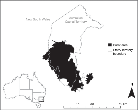
The 2019–2020 Australian fire season was characterised by numerous wildfires that affected vast tracts of land in south-eastern Australia, with an estimated combined fire ground area of 5.4 million ha across New South Wales (NSW) and the Australian Capital Territory (ACT) (NSW Department of Planning, Industry and Environment 2020). One of these fires – the Orroral Valley Fire (Fig. 1) – was chosen as a case study to investigate the research objectives due to its unique availability of detailed fire progression information and high pulse density pre-fire LiDAR data. The Orroral Valley Fire burned from late January to early February 2020 and affected an estimated 86 562 ha of primarily native resprouting eucalyptus forest that burnt under varying weather conditions and resulted in a mosaic of fire severity (ACT EPSDD 2020). The structural diversity of fire-affected forest types enables analysis of the effects of diverse pre-fire VH and TVC on remotely sensed fire severity.
|
Fire severity estimation
The NBR (Eqn 1) incorporates Near Infrared (NIR) and Short-wave Infrared (SWIR) reflectance and commonly represents a basis for estimating fire severity via comparing pre-fire and post-fire NBR grids. NBR is positively correlated to vegetation leaf area (Roy et al. 2006; Massetti et al. 2019), soil and foliar moisture (Miller and Thode 2007; Chuvieco et al. 2020), and photosynthetic capacity (Levin et al. 2012).
The differenced NBR (dNBR), Relative dNBR (RdNBR), and Relativised Burn Ratio (RBR) represent fire severity as a change of gridded NBR. These indices are commonly employed in fire severity spatial analyses (e.g. Kane et al. 2013; Collins et al. 2014; Ndalila et al. 2018; García-Llamas et al. 2020; Hislop et al. 2020). The dNBR (Eqn 2) quantifies the absolute change of NBR between pre-fire and post-fire image acquisitions (Miller and Thode 2007). The dNBR offset accounts for the background change of NBR between pre- and post-fire dates in the adjacent unburnt area, though its calculation can be subjective (Picotte et al. 2020) and it is not recommended for use when the unburnt area may be atypical of the burnt area (Parks et al. 2018). Given the extensive area and diversity of vegetation types affected by the Orroral Valley Fire (ACT EPSDD 2020), the dNBR offset was not employed when deriving dNBR due to concern for an offset area being atypical of the fire-affected area.

The RdNBR considers pre-fire NBR as a mathematical denominator (Eqn 3), therefore representing a fire severity estimate that is relative to pre-fire conditions (Miller and Thode 2007).
Finally, the RBR addresses a tendency for the RdNBR to produce anomalous fire severity estimates, when pre-fire NBR is close to zero or negative, via a reformulation of pre-fire NBR in the denominator (Parks et al. 2014a, Eqn 4).
The dNBR, RdNBR and RBR were tested as separate response variables when analysing effects of environmental predictors on the severity of the Orroral Valley Fire. While differing in their representation of either absolute or relative estimates of change, these indices use the same optical reflectance bands. Further, the dNBR, RdNBR and RBR have demonstrated robust estimation of fire severity in Australian forest types (Tanase et al. 2015; Tran et al. 2018; Yin et al. 2020), are most commonly applied as direct representations of fire severity (Keeley 2009; Lutz et al. 2011), and are common inputs in other remote sensing products (Hudak et al. 2004; Gibson et al. 2020). These three indices, therefore, give broadly relevant insight into the influence of pre-fire TVC and VH on fire severity spatial analyses, while allowing investigation of differences arising between commonly used estimates.
Pre- and post-fire Sentinel 2A/B Multispectral Instrument images were acquired for the Orroral Valley Fire from the Copernicus Open Access Hub (scihub.copernicus.eu). Level 2A (L2A) reflectance products for the T55HFA Universal Transverse Mercator system tile were sourced, which represents scene-classified, radiometrically and terrain-corrected Bottom of Atmosphere surface reflectance derived from the Sen2Cor algorithm (Main-Knorn et al. 2017). NBR gridded values were derived for the study area at 20 m resolution using cloud-free Sentinel 2A/B images acquired on 25 January 2020 and 15 March 2020, respectively. Invalid reflectance pixels were indicated by Sentinel-2 L2A scene classifications and excluded.
Predictor variables
Fire progression data and half-hourly weather observations were incorporated to account for variation in fire severity due to weather conditions (Table 1). A combination of airborne linescan data (ACT Emergency Services Agency unpublished data) and satellite multispectral observations from Landsat 8 and Sentinel-2 platforms were used to map the progression of the Orroral Valley Fire. Active fire perimeters were identified and digitised from these sources following manual inspection, and timings of fire arrival were attributed to areas based on corresponding imagery acquisition timings. Half-hourly windspeed, wind direction, temperature and humidity observations were sourced from the nearest weather station (Mount Ginini, station no. 070339, Australian Bureau of Meteorology), which is located approximately 25 km from the centre of the fire and at 1762 m elevation. To indicate weather conditions during the fire, active fire perimeters from linescan data were assigned the temporally closest half-hourly weather observations from the weather station. Rather than combining into a single fire weather index, fire weather variables were modelled as separate predictors as per Collins et al. (2007) and Prichard and Kennedy (2014) to avoid assumptions of their relative contributions. Only burnt areas within 200 m of mapped active fire perimeters were considered to avoid uncertainties regarding fire progression between acquisitions.

|
Slope, topographic aspect, elevation, and Topographic Wetness (TWI) and Position (TPI) indices were determined for the study area from a Digital Elevation Model (DEM) derived from airborne Light Detection and Ranging (LiDAR) data. Topographic variables were derived at 20 m resolution to align with Sentinel-2 derived fire severity products. The TPI indicates the elevation of a gridded pixel relative to the mean elevation of neighbouring pixels within a distance window, which was set to 400 m following manual inspection of the landscape. The effect of TWI was also modelled to account for variation in moisture associated with the accumulation of water flow. As per Collins et al. (2014), aspect was modelled as a continuous measure relative to north, ranging from 0 to 180° (whereby values closer to 0° represented more northerly aspects). Time since fire was derived for the study area from an ACT fire history spatial dataset (ACT EPSDD unpublished data).
Further to commonly modelled fire severity predictor variables (Table 1), pre-fire vegetation height (VH) and tall vegetation cover (TVC) were estimated using pre-fire LiDAR data acquired in 2015. LiDAR data were collected using a Trimble AX60 LiDAR device at an average flying height of 450 m above ground, laser footprint size of 0.12 m, and average density of 4 pulses per square metre. A DEM was derived using a Triangular Irregular Network of ground-classified LiDAR returns and gridded to 1 m resolution. VH and TVC were estimated as metrics of the indexed LiDAR point cloud (Hopkinson et al. 2005; Price and Gordon 2016). First, the height above ground of each non-ground classified return was determined as the nearest 1 m resolution DEM pixel subtracted from the return z-value (Fisher et al. 2020). Following Wulder et al. (2012) and Bolton et al. (2013), VH was calculated as the 95th percentile of LiDAR return Heights Above Ground (HAGs) greater than 2 m, with this height threshold aligning with the definition of a tree as having the potential to reach a minimum of 2 m at maturity in situ (Killmann 2002). Similar to Caynes et al. (2016) and Price and Gordon (2016), we determined TVC as the fraction of LiDAR returns greater than 3 m above ground, relative to all returns within and below this vertical layer. Although Price and Gordon (2016) found that LiDAR point return fractions consistently underestimated measured vegetation cover in eucalypt forest, the method provided a precise measure of vegetation cover with a high variance of field estimates. Areas burnt between the 2015 LiDAR data acquisition and 2020 Orroral Valley Fire were excluded from analyses to avoid potentially unrepresentative TVC and VH estimates. The study area was last subject to major wildfire in 2003, and previous research suggests that canopy height and cover in resprouting eucalypt forests are unlikely to change significantly in the time elapsed between the LiDAR acquisition and Orroral Valley Fire (Wilson et al. 2021).
Sampling and analysis methods
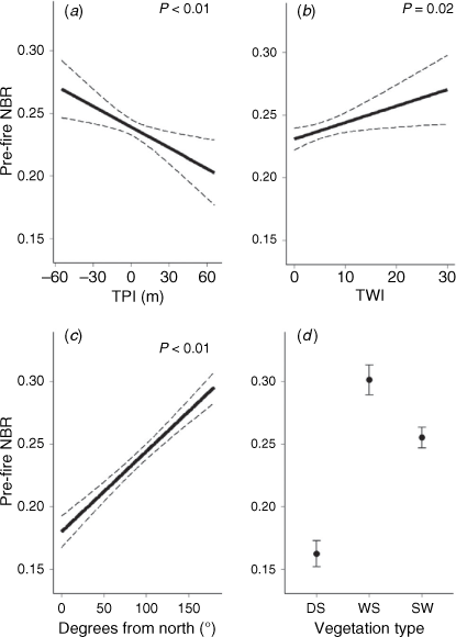
A spatial autocorrelation explanatory variable was used to account for the spatial dependence between the fire severity response variables and neighbouring fire severity. The degree of relationship between gridded fire severity points at various distance intervals was indicated by semivariance (Meisel and Turner 1998; He et al. 2007). Similar to Price and Bradstock (2012) and Collins et al. (2014), spatial autocorrelation existed in dNBR, RdNBR and RBR grids for a distance of up to 10.5 km, where semivariance becomes approximately equal to the variance of the fire severity surface. As per Price and Bradstock (2012) and Collins et al. (2014), we therefore determined a Spatially Lagged Response Variable (SLRV) for each response variable (Haining and Haining 2003):
where i represents the sample point, j represents a point within a 10.5 km radius of i, W represents a Euclidean inverse distance weighting of the distance between i and j, and Y represents the fire severity value at the distant point. Effects of predictor variables after accounting for the SLRV variable can be inferred to have real effects rather than reflecting potential artifacts caused by spatial lag (Price and Bradstock 2012).
Data were extracted from the spatial layers at points on a regular 400 m grid, which indicates the approximate ridge–gully spacing distance for the study area. Sampling points within 100 m of roads, trails, powerlines and significant water bodies were discarded. Predictive models of fire severity, allowing for complex non-linear relationships, were developed with non-parametric modelling. In this approach, the relative importance of the predictor variables was not a function of the linearity of their relationships to fire severity. Further, this approach avoids potential over-evaluation of variable importance introduced by user-specified application of non-linear terms. We applied Random Forests Modelling (RFM) (Breiman 2001) to evaluate the performance of environmental predictor variables. RFM is a machine learning approach that has previously been applied to investigate complex relationships between fire severity and environmental predictors (Thompson and Spies 2009; Kane et al. 2015; Ying et al. 2018; García-Llamas et al. 2019; Hoff et al. 2019). RFM constructs multiple decision trees, which recursively partition observations into homogenous groups, from random subsets of data and predictor variables to reduce model overfitting. Model performance was initially evaluated using both out-of-bag (OOB) error rates and the Root Mean Square Error (RMSE) of model predictions obtained from separate randomly subsampled training and validation sets, comprising 2/3 and 1/3 of observations, respectively. Errors derived from both approaches were approximately equal, and therefore the OOB error rates are presented. Predictor variable importance was indicated by the increase in Mean Squared Error (MSE) when each variable is randomly permuted while others remain unchanged. Further, partial dependence plots were used to illustrate the effects of individual predictors on fire severity while holding all other predictors at their average. RFMs were constructed using the random Forest package in R (Liaw 2018).
Correlations among predictor variables were indicated by Spearman rank correlation, which represents monotonic non-linear correlation between variables. There were no strong correlations (ρ > 0.5) between predictor variables in RFMs, thereby reducing modelling uncertainties associated with multicollinearity. Simple univariate Generalised Linear Models (GLM) were used to further investigate relationships between commonly invoked environmental predictors (Table 1) and potentially confounding pre-fire variables of VH, TVC and NBR. GLMs were constructed with a Gaussian distribution using the glm function in R (Marschner 2011).
Results
Pre-fire LiDAR-derived vegetation height was an important predictor of remotely sensed fire severity indices, and the effects and importance of our model predictor variables differed substantially among the three indices. VH was the second-most important variable in predicting RdNBR, after spatial lag, with a 25.5% increase of Mean Squared Error (MSE) when randomly permuted (Fig. 2). VH was also an important variable in predicting dNBR and RBR, with equivalent importance to key fire weather variables. TVC and topographic variables generally contributed less to predicting the fire severity indices compared to VH and fire weather variables. RFMs explained more variance in RdNBR (R2 = 0.395, RMSE = 332) than RBR (R2 = 0.268, RMSE = 92.2) and dNBR (R2 = 0.229, RMSE = 121).

|
As indicated by RFM partial dependence plots (Fig. 3), increased pre-fire VH resulted in lower fire severity across the three indices, and the magnitude of this effect was greater than that of other environmental predictors, including weather variables. The effects of other predictor variables varied between the three fire severity indices. Aspect was an important predictor of RdNBR and RBR, but less important in predicting dNBR (Figs 2, 3). Similarly, increased TVC was associated with decreasing RdNBR but increasing dNBR (Fig. 3). The importance and effects of VH and fire weather response variables in predicting remotely sensed fire severity were generally consistent across the three indices (Figs 2, 3).

|
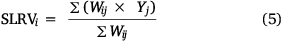
In parallel with substantial effects of VH on optical remote sensing fire severity indices, there were significant relationships between pre-fire VH and commonly modelled environmental predictors, including Topographic Position Index, Topographic Wetness Index, and aspect (Fig. 4). Pre-fire VH was greater in topographically lower-lying and wetter areas, and on easterly and southerly (poleward in the southern hemisphere) aspects. There were no significant relationships between pre-fire TVC and these response variables (P > 0.05 in all instances). Fire history and slope were also not significantly related to pre-fire VH or TVC (P > 0.05 in all instances).
|
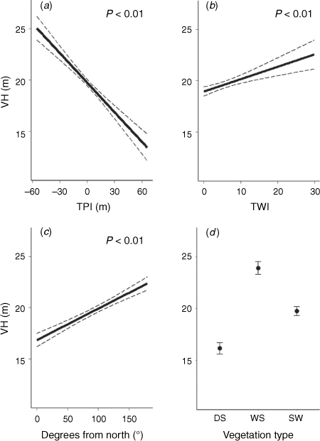
As a further consideration for drawing robust inferences from predictor effects on optical remote sensing fire severity indices (Fig. 3) – pre-fire Normalised Burn Ratio, which forms the basis of the dNBR, RdNBR and RBR, was significantly related to commonly modelled environmental predictors (Fig. 5). Pre-fire NBR was significantly higher in lower and wetter areas, and on more southerly aspects (Fig. 5). Importantly, however, the three fire severity response variables differed substantially in their correlation to pre-fire NBR (Fig. 6) due to differences in their formulation. RdNBR was moderately negatively correlated to pre-fire NBR (ρ = −0.45), whereas dNBR was moderately positively correlated (ρ = 0.21). There was limited correlation between RBR and pre-fire NBR (ρ = −0.03).
|

|
Discussion
Our results indicate two important considerations for inferring robust insights from spatial analyses of optical remote sensing fire severity indices. First, relationships between fire severity and commonly invoked environmental predictors differed substantially across three commonly applied optical indices, being the dNBR, RdNBR, and RBR (Fig. 2, 3). Second, variation in remotely sensed fire severity index estimates was strongly controlled by pre-fire Vegetation Height (VH) (Fig. 2). Importantly, pre-fire VH and NBR also covaried with commonly modelled environmental predictors (Fig. 4, 5). This indicates that effects of environmental variables on remotely sensed fire severity index estimates may largely be explained by VH mechanisms and aspects of index computation. Pre-fire Tall Vegetation Cover (TVC) was less important in predicting fire severity estimates and did not covary with the environmental predictors used in our case study, though may be more influential in forests with more pronounced disturbance histories. We discuss the importance of response variable selection and consideration of pre-fire VH and TVC effects for generating robust insights from fire severity spatial analyses. We then discuss the implications of our findings for inferring fire behaviour effects from these analyses.
Importance of optical fire severity index selection
Similar to findings of Parks et al. (2014a) and Miller and Thode (2007), dNBR was moderately positively correlated to pre-fire NBR (ρ = 0.21; Fig. 6c). This has been attributed to the dNBR representing absolute change that is inherently related to the amount of photosynthetic vegetation, and therefore NBR, that can potentially be removed (Eqn 2) (Miller and Thode 2007). Relative versions of differenced fire severity indices, such as the RdNBR (Miller and Thode 2007) and RBR (Parks et al. 2014a), aim to minimise estimation bias corresponding to pre-fire NBR. Similar to Parks et al. (2014a), the RBR was uncorrelated to pre-fire NBR for the Orroral Valley Fire (ρ = −0.03; Fig. 6b). However, we determined moderate negative correlation between pre-fire NBR and RdNBR (ρ = −0.45; Fig. 6a), dissimilar to weak correlation observed by Miller and Thode (2007). This discrepancy may be attributed to the exceptionally dry pre-fire condition in our study area, which had very low and often negative NBR values in forested areas. These dissimilar correlations between fire severity and pre-fire NBR suggest that these indices cannot be generalised as relating to a single definition and interpretation of fire severity.
Correlations between pre-fire NBR and optical fire severity index estimates are magnified when regressing these estimates against environmental predictors that covary with NBR. Pre-fire NBR is indicative of pre-fire photosynthetic biomass (Tucker 1979) and soil and foliar moisture (Miller and Thode 2007; Chuvieco et al. 2020). In our study, NBR varied with topography and vegetation types (Fig. 5), although it may also correlate to environmental predictors not employed in our study, such as logging and thinning history (Seedre and Chen 2010). Given the substantially varying correlations between pre-fire NBR and the three response variables (Fig. 6), the effects of environmental predictors on optical fire severity index estimates may therefore represent their correlations to pre-fire NBR, rather than typically inferred influences (e.g. topography and vegetation type) on physical fire effects. Importantly, the confounding relationship between pre-fire NBR and environmental predictors suggests that the results of fire severity spatial analyses that employ NBR based indices are, to a substantial degree, dependent on the choice of index.
The influence of different remote sensing indices can explain contrasting results across previous fire severity spatial analyses. For example, in North American boreal forest, studies have determined positive correlations between an absolute index, dNBR, and environmental predictors that covary with pre-fire photosynthetic biomass (e.g. wetter topographic positions, greater time since disturbance) (Cocke et al. 2005; Wimberly et al. 2009; Arkle et al. 2012; Parks et al. 2014b). However, studies employing a relative index (i.e. RdNBR and RBR) found inverse correlations to these predictors (Lyons-Tinsley and Peterson 2012; Meigs et al. 2020). While determinants of fire severity can be expected to vary regionally (Ying et al. 2018), these contrasting findings align with differences in mathematical treatment of pre-fire NBR and with differences in predictor effects observed in our study (Fig. 3). Unless fire severity is defined exclusively as a remote sensing index, we recommend greater consideration of the limited physical meaning of these estimates (Tucker 1979; Roy et al. 2006), and the different representations of change expressed by absolute and relative indices (Miller and Thode 2007; Parks et al. 2014a). Although less commonly applied in fire severity spatial analyses, alternate remotely sensed estimates, such as those derived from Radiative Transfer Modelling, Spectral Mixture Analysis, or non-parametric regression (e.g. Quintano et al. 2013; Gibson et al. 2020; Yin et al. 2020) may provide clearer representations of physical fire effects and should be considered in future analyses.
Vegetation height effects on fire severity
Fire weather is generally held to be the dominant determinant of fire severity in Australian forests (Sullivan et al. 2012; Penman et al. 2013; Collins et al. 2014). However, in predicting optical fire severity indices, pre-fire Vegetation Height (VH) had equivalent or greater importance compared to fire weather variables (Fig. 2). Shorter-canopied vegetation is more susceptible to satellite-observable vegetation scorch and consumption resulting from understorey fire (Chafer et al. 2004; Hammill and Bradstock 2006), and NBR indices, therefore, reflect this expected fire severity effect. Findings from studies in Mediterranean and North American forest types have suggested that vegetation height also plays an important role in determining remotely sensed fire severity in other environments (Alexander et al. 2006; García-Llamas et al. 2019; Fernández-Guisuraga et al. 2021; Taylor et al. 2021), although the relative strength of vegetation height effects may be influenced by its heterogeneity within a fire-affected area (Mitsopoulos et al. 2019).
Covariation between commonly invoked environmental predictor variables and VH (Fig. 4) suggests that predictor effects on optical fire severity index estimates are explained by VH. For example, fire severity has been associated with topography, with lower severity fire generally occurring in lower, wetter, and less sun-exposed topographic positions (Bradstock et al. 2010; Kane et al. 2015; Meigs et al. 2020). Our results demonstrate the propositions of Chafer et al. (2004), Alexander et al. (2006), Bradstock et al. (2010), and Viedma et al. (2020) – that a substantial degree of influence of topography on optical fire severity indices is caused by its covariation with vegetation height. Despite significant covariation between topographic predictors and VH (Fig. 4), topography was generally unimportant for predicting fire severity for our case study (Fig. 2). Topography was similarly a poor predictor of fire severity for other 2019/2020 Australian wildfires, possibly resulting from overriding fuel dryness and prolonged extreme fire weather (Bowman et al. 2021). Further, although we suggest that significant covariation between topographic predictors and VH warrants consideration in fire severity spatial analyses, vegetation height is determined by additional factors, including soil properties, species assemblages and local climate (Givnish et al. 2014). As a result, we suggest that our LiDAR derived VH variable provides a better indication of variation in vegetation height than topographic variables, and topographic covariates may have low RFM variable importance because they provide little additional information for predicting the response (Strobl et al. 2008).
Fire history had no relation with VH, and limited effect on optical fire severity index estimates (Fig. 3). This might be expected given that the study area had a mosaic of low intensity prescribed fire and is characterised by tree species known to resprout following fire (Florence 1973; Vivian et al. 2008). Further, we excluded recently burnt areas (<5 years) where prescribed burns are suggested to have the greatest effect on fuel characteristics and fire behaviour (Bradstock et al. 2012; Penman et al. 2011). Covariation between fire history and vegetation height may be more apparent in environments subject to stand-replacing fire or other major disturbances such as logging (Gosper et al. 2013; Rutishauser et al. 2016; Wilson et al. 2021). As a result, covariation with VH should be considered as a potential mechanism of environmental predictor effects on optical fire severity indices.
Tall vegetation cover effects on fire severity
Contrary to our initial hypothesis, pre-fire Tall Vegetation Cover (TVC) was not negatively associated with optical fire severity index estimates (Fig. 3) and did not covary with topography or disturbance history. Our proposition – that TVC may affect fire severity due to its influence on satellite optical obscuration of sub-canopy fire effects (Yin et al. 2020) – was therefore not supported. Fire severity may be poorly related to TVC in our study because the 3 m height threshold defining canopy LiDAR returns could be too low to adequately represent potentially obscuring vegetation. Further, increased mid-storey and canopy fuel load may cause more extreme fire behaviour and potentially higher fire severity (Wagner 1977; Hall and Burke 2006), thereby cancelling expected obscuration effects.
Although TVC demonstrated limited association with optical fire severity indices in our study, other studies have determined that canopy cover is an important influence on fire severity and detection methods. In North American broadleaf and deciduous forests, the lowest fire severity classification accuracies for the RdNBR corresponded to high severity fire occurring in low pre-fire canopy cover (user’s accuracy = 45.5%), and low severity fire occurring in high pre-fire canopy cover (user’s accuracy = 51.4%), compared to more typical accuracies between 55 and 85% (Miller et al. 2009). Further, Yin et al. (2020) integrated pre-fire canopy cover into optical remote sensing models of fire severity to improve classification accuracy in Australian and North American study areas. Although not a focus of our study, fire detection methods that use instruments such as the Moderate Resolution Imaging Spectroradiometer (MODIS) and Visible Infrared Imaging Radiometer Suite (VIIRS) are also suggested to exhibit error from obscuration of surface fires by overstorey vegetation (Roy et al. 2008; Giglio et al. 2009; Roy and Kumar 2017). However, the degree of overstorey obscuration effects on fire detection products is unclear given the complexity of burnt area algorithms and their sensitivity to input data quality (Roy et al. 2008).
Similarly, TVC was unrelated to environmental predictors in our study, though may co-vary with predictors in other study areas. For example, canopy cover can vary as a function of topographic variables, including aspect and topographic wetness (Mackay and Band 1997; Bale et al. 1998), forest type (Nemani and Running 1997), and disturbance and land management variables, including stand age, fire history, logging history, and forest thinning (Thomas et al. 1999; Harper et al. 2002; Lindenmayer et al. 2012). We recommend consideration and further investigation of the potential for optical sensor obscuration to confound the effects of environmental variables on optical fire severity index estimates.
Implications for inferring fire behaviour
Remotely sensed fire severity may be invoked to generate insights into fireline intensity, fire suppressibility, fire risk, flammability, or contributing fuel properties (Taylor et al. 2014; Fang et al. 2015; Zald and Dunn 2018; García-Llamas et al. 2019; Taylor et al. 2020). While variation of optical fire severity index estimates is partly caused by fire behaviour (Heward et al. 2013), our results suggest that this relationship is strongly confounded by VH. Heat decreases with increasing vertical distance above flames (Alexander and Cruz 2012) and, assuming constant canopy cover and fireline intensity, optical remote sensing is logically more likely to detect fire effects in shorter vegetation (Chafer et al. 2004; Hammill and Bradstock 2006) (Fig. 7). This mechanistic understanding aligns with our finding of substantially higher fire severity in areas of shorter vegetation (Fig. 3). Translation of optical fire severity indices to indicate fireline intensity, without regard for spatial variation in vegetation height, effectively assumes that there is no effect of height above flames on heat from fire. Alternatively, spatial variation in VH may also indicate spatial variation in fuel moisture (Bradstock et al. 2010), which can influence fireline intensity (Kreye et al. 2011). However, we argue that the extreme pre-fire dryness of the study area (ACT EPSDD 2020) which is typical of large wildfires (Nolan et al. 2016), in addition to our modelled incorporation of topographic variables that indicate fuel moisture (e.g. TWI, TPI, aspect), suggests that moisture is a lesser contributing mechanism to the observed VH effect.

|
Although our study determined little evidence that TVC controls variation in optical fire severity indices, it may be important to understanding links between fire severity and intensity, particularly in study areas with pronounced disturbance histories. Passive optical remote sensors capture two-dimensional information of the vegetation layer or land surface that is visible to the satellite (Hoe et al. 2018). Optical remote sensing indices primarily detect disturbance to the forest canopy in environments with a high cover of tall vegetation, and conversely, disturbance of understorey and surface vegetation and soil will contribute significantly to optical signals where tall vegetation is sparse (Spanner et al. 1990; Stenback and Congalton 1990; Miller et al. 2009; Yin et al. 2020). As a result, equivalent fireline intensity and field-measured fire severity may correspond to a high index estimate of fire severity in an open forest, and a low or unchanged estimate in a closed forest (Fig. 7). This aligns with the findings of Heward et al. (2013), who determined that high RdNBR in low canopy cover forest had equivalent fireline characteristics to low–moderate RdNBR in high canopy cover forest. Fire behaviour insights drawn from optical fire severity indices may therefore confound increased visibility of fire effects as representing increased fireline intensity.
We recommend against inferring fireline intensity from optical fire severity indices, given that the relationship is confounded by VH and potentially TVC, unless these vegetation variables are explicitly accounted for. In some cases, studies may discuss or emphasise, to some extent, the importance of explanatory mechanisms relating to fireline intensity, fire suppressibility, fire risk, flammability, or contributing fuel properties, from remotely sensed fire severity without explicitly invoking the confounding effects determined in our study (Taylor et al. 2014; Fang et al. 2015; Zald and Dunn 2018; García-Llamas et al. 2019; Taylor et al. 2020). Similarly, covariation of confounding vegetation attributes with other environmental predictors may not be recognised. For example, findings of the contribution of forest management to optical fire severity in Australian eucalypt forests (Taylor et al. 2014; Taylor et al. 2020) enable important and meaningful fire severity insights, though the degree that these effects may be influenced by changes in VH and TVC associated with this management (Harper et al. 2002; Lindenmayer et al. 2012; Gosper et al. 2013; Rutishauser et al. 2016) requires further investigation. Robust fire behaviour insights from fire severity analysis are therefore more challenging due to the confounding influences of VH, and potentially TVC. While it may be possible to account for pre-fire VH and TVC effects in fire severity spatial analysis methods, there is nevertheless some degree of inseparability between these mechanisms and potentially covarying mechanisms such as fuel moisture and load.
Conclusions
Analyses of environmental determinants of fire severity commonly apply optical remote sensing indices but do not typically consider their foundations and limitations. We demonstrated two important considerations when analysing spatial variation of optical fire severity index estimates. First, different remote sensing indices (dNBR, RdNBR, RBR) gave rise to different relationships between fire severity and environmental predictors. These differences can be explained by contrasting computational treatment of pre-fire NBR, which covaried with environmental predictors. Second, taller pre-fire Vegetation Height substantially decreased optical fire severity index estimates, with equivalent variable importance to fire weather. This effect can be mechanistically explained by taller vegetation being more vertically distant from flames. Finally, although we determined a lesser influence of pre-fire Tall Vegetation Cover, it may influence fire severity estimates by obscuring fire effects. Importantly, due to strong covariation with VH and potentially TVC, commonly invoked environmental predictors should not be considered as effects on fireline intensity and related fire behaviour concepts. To avoid potentially spurious interpretations, selection of appropriate remote sensing estimates for spatial analyses should consider the bias and meaning that is specific to these estimates, in relation to the fire severity definition adopted for any particular study. Optical indices are important and useful methods for rapid and cost-effective fire severity assessment and, withstanding these key considerations, analyses of the determinants of these estimates may contribute to improved understanding and management of fire-prone environments.
Data availability
Some data that support this study were obtained from the ACT EPSDD by permission. This data may be shared upon reasonable request to the corresponding author subject to permission from the ACT EPSDD. Other data that support this study will be shared upon reasonable request to the corresponding author.
Conflicts of interest
Geoffrey Cary is an Associate Editor of International Journal of Wildland Fire, but was blinded from the peer-review process for this paper.
Declaration of funding
This research was partially funded by an Australian Government Research Training Program Scholarship.
Acknowledgements
We thank ACT Parks and Conservation Service for providing spatial data on the progression of the Orroral Valley Fire.
References
ACT EPSDD (2020) Orroral valley fire rapid risk assessment Namadgi national park. ACT Government Report. (Canberra, ACT, Australia).Alexander ME, Cruz MG (2012) Interdependencies between flames length and fireline intensity in predicting crown fire initiation and crown scorch height. International Journal of Wildland Fire 21, 95–113.
| Interdependencies between flames length and fireline intensity in predicting crown fire initiation and crown scorch height.Crossref | GoogleScholarGoogle Scholar |
Alexander JD, Seavy NE, Ralph CJ, Hogoboom B (2006) Vegetation and topographical correlates of fire severity from two fires in the Klamath-Siskiyou region of Oregon and California. International Journal of Wildland Fire 15, 237–245.
| Vegetation and topographical correlates of fire severity from two fires in the Klamath-Siskiyou region of Oregon and California.Crossref | GoogleScholarGoogle Scholar |
Arkle RS, Pilliod DS, Welty JL (2012) Pattern and process of prescribed fires influence effectiveness at reducing wildfire severity in dry coniferous forests. Forest Ecology and Management 276, 174–184.
| Pattern and process of prescribed fires influence effectiveness at reducing wildfire severity in dry coniferous forests.Crossref | GoogleScholarGoogle Scholar |
Bale CL, Williams JB, Charley JL (1998) The impact of aspect on forest structure and floristics in some Eastern Australian sites. Forest Ecology and Management 110, 363–377.
| The impact of aspect on forest structure and floristics in some Eastern Australian sites.Crossref | GoogleScholarGoogle Scholar |
Birch DS, Morgan P, Kolden CA, Abatzoglou JT, Dillon GK, Hudak AT, Smith AM (2015) Vegetation, topography and daily weather influenced burn severity in central Idaho and western Montana forests. Ecosphere 6, 1–23.
| Vegetation, topography and daily weather influenced burn severity in central Idaho and western Montana forests.Crossref | GoogleScholarGoogle Scholar |
Bolton DK, Coops NC, Wulder MA (2013) Measuring forest structure along productivity gradients in the Canadian boreal with small-footprint Lidar. Environmental Monitoring and Assessment 185, 6617–6634.
| Measuring forest structure along productivity gradients in the Canadian boreal with small-footprint Lidar.Crossref | GoogleScholarGoogle Scholar | 23291915PubMed |
Bowman DMJS, Williamson GJ, Gibson R, Bradstock RA, Keenan RJ (2021) The severity and extent of the Australia 2019–20 Eucalyptus forest fires are not the legacy of forest management. Nature Ecology & Evolution 5, 1003–1010.
| The severity and extent of the Australia 2019–20 Eucalyptus forest fires are not the legacy of forest management.Crossref | GoogleScholarGoogle Scholar |
Bradstock RA, Hammill KA, Collins L, Price O (2010) Effects of weather, fuel and terrain on fire severity in topographically diverse landscapes of south-eastern Australia. Landscape Ecology 25, 607–619.
| Effects of weather, fuel and terrain on fire severity in topographically diverse landscapes of south-eastern Australia.Crossref | GoogleScholarGoogle Scholar |
Bradstock RA, Boer MM, Cary GJ, Price OF, Williams RJ, Barrett D, Cook G, Gill AM, Hutley L, Keith H (2012) Modelling the potential for prescribed burning to mitigate carbon emissions from wildfires in fire-prone forests of Australia. International Journal of Wildland Fire 21, 629–639.
| Modelling the potential for prescribed burning to mitigate carbon emissions from wildfires in fire-prone forests of Australia.Crossref | GoogleScholarGoogle Scholar |
Breiman L (2001) Random forests. Machine Learning 45, 5–32.
| Random forests.Crossref | GoogleScholarGoogle Scholar |
Caynes RJ, Mitchell MG, Wu DS, Johansen K, Rhodes JR (2016) Using high-resolution LiDAR data to quantify the three-dimensional structure of vegetation in urban green space. Urban Ecosystems 19, 1749–1765.
| Using high-resolution LiDAR data to quantify the three-dimensional structure of vegetation in urban green space.Crossref | GoogleScholarGoogle Scholar |
Chafer CJ, Noonan M, Macnaught E (2004) The post-fire measurement of fire severity and intensity in the Christmas 2001 Sydney wildfires. International Journal of Wildland Fire 13, 227–240.
| The post-fire measurement of fire severity and intensity in the Christmas 2001 Sydney wildfires.Crossref | GoogleScholarGoogle Scholar |
Chuvieco E, Aguado I, Salas J, García M, Yebra M, Oliva P (2020) Satellite remote sensing contributions to wildland fire science and management. Current Forestry Reports 6, 81–96.
| Satellite remote sensing contributions to wildland fire science and management.Crossref | GoogleScholarGoogle Scholar |
Cocke AE, Fulé PZ, Crouse JE (2005) Comparison of burn severity assessments using Differenced Normalized Burn Ratio and ground data. International Journal of Wildland Fire 14, 189–198.
| Comparison of burn severity assessments using Differenced Normalized Burn Ratio and ground data.Crossref | GoogleScholarGoogle Scholar |
Collins BM, Kelly M, Van Wagtendonk JW, Stephens SL (2007) Spatial patterns of large natural fires in Sierra Nevada wilderness areas. Landscape Ecology 22, 545–557.
| Spatial patterns of large natural fires in Sierra Nevada wilderness areas.Crossref | GoogleScholarGoogle Scholar |
Collins L, Bradstock R, Penman T (2014) Can precipitation influence landscape controls on wildfire severity? A case study within temperate eucalypt forests of south-eastern Australia. International Journal of Wildland Fire 23, 9–20.
| Can precipitation influence landscape controls on wildfire severity? A case study within temperate eucalypt forests of south-eastern Australia.Crossref | GoogleScholarGoogle Scholar |
Fang L, Yang J, Zu J, Li G, Zhang J (2015) Quantifying influences and relative importance of fire weather, topography, and vegetation on fire size and fire severity in a Chinese boreal forest landscape. Forest Ecology and Management 356, 2–12.
| Quantifying influences and relative importance of fire weather, topography, and vegetation on fire size and fire severity in a Chinese boreal forest landscape.Crossref | GoogleScholarGoogle Scholar |
Fernández-Guisuraga JM, Suárez-Seoane S, García-Llamas P, Calvo L (2021) Vegetation structure parameters determine high burn severity likelihood in different ecosystem types: A case study in a burned Mediterranean landscape. Journal of Environmental Management 288, 112462
| Vegetation structure parameters determine high burn severity likelihood in different ecosystem types: A case study in a burned Mediterranean landscape.Crossref | GoogleScholarGoogle Scholar | 33831636PubMed |
Fisher A, Armston J, Goodwin N, Scarth P (2020) Modelling canopy gap probability, foliage projective cover and crown projective cover from airborne lidar metrics in Australian forests and woodlands. Remote Sensing of Environment 237, 111520
| Modelling canopy gap probability, foliage projective cover and crown projective cover from airborne lidar metrics in Australian forests and woodlands.Crossref | GoogleScholarGoogle Scholar |
Florence R (1973) ‘A resource and management survey of the Cotter River catchment.’ (Dept Forestry, Australian National University: Canberra, ACT, Australia)
García-Llamas P, Suárez-Seoane S, Taboada A, Fernández-Manso A, Quintano C, Fernández-García V, Fernández-Guisuraga JM, Marcos E, Calvo L (2019) Environmental drivers of fire severity in extreme fire events that affect Mediterranean pine forest ecosystems. Forest Ecology and Management 433, 24–32.
| Environmental drivers of fire severity in extreme fire events that affect Mediterranean pine forest ecosystems.Crossref | GoogleScholarGoogle Scholar |
García-Llamas P, Suárez-Seoane S, Fernández-Manso A, Quintano C, Calvo L (2020) Evaluation of fire severity in fire prone-ecosystems of Spain under two different environmental conditions. Journal of Environmental Management 271, 110706
| Evaluation of fire severity in fire prone-ecosystems of Spain under two different environmental conditions.Crossref | GoogleScholarGoogle Scholar | 32778251PubMed |
Gibson R, Danaher T, Hehir W, Collins L (2020) A remote sensing approach to mapping fire severity in south-eastern Australia using sentinel 2 and random forest. Remote Sensing of Environment 240, 111702
| A remote sensing approach to mapping fire severity in south-eastern Australia using sentinel 2 and random forest.Crossref | GoogleScholarGoogle Scholar |
Giglio L, Loboda T, Roy DP, Quayle B, Justice CO (2009) An active-fire based burned area mapping algorithm for the MODIS sensor. Remote Sensing of Environment 113, 408–420.
| An active-fire based burned area mapping algorithm for the MODIS sensor.Crossref | GoogleScholarGoogle Scholar |
Givnish TJ, Wong SC, Stuart-Williams H, Holloway-Phillips M, Farquhar GD (2014) Determinants of maximum tree height in Eucalyptus species along a rainfall gradient in Victoria Australia. Ecology 95, 2991–3007.
| Determinants of maximum tree height in Eucalyptus species along a rainfall gradient in Victoria Australia.Crossref | GoogleScholarGoogle Scholar |
Gosper CR, Prober SM, Yates CJ, Wiehl G (2013) Estimating the time since fire of long-unburnt Eucalyptus salubris (Myrtaceae) stands in the Great Western Woodlands. Australian Journal of Botany 61, 11–21.
| Estimating the time since fire of long-unburnt Eucalyptus salubris (Myrtaceae) stands in the Great Western Woodlands.Crossref | GoogleScholarGoogle Scholar |
Haining RP, Haining R (2003) ‘Spatial data analysis: theory and practice.’ (Cambridge University Press: Cambridge)
Hall SA, Burke IC (2006) Considerations for characterizing fuels as inputs for fire behavior models. Forest Ecology and Management 227, 102–114.
| Considerations for characterizing fuels as inputs for fire behavior models.Crossref | GoogleScholarGoogle Scholar |
Hammill KA, Bradstock RA (2006) Remote sensing of fire severity in the Blue Mountains: influence of vegetation type and inferring fire intensity. International Journal of Wildland Fire 15, 213–226.
| Remote sensing of fire severity in the Blue Mountains: influence of vegetation type and inferring fire intensity.Crossref | GoogleScholarGoogle Scholar |
Harper K, Bergeron Y, Gauthier S, Drapeau P (2002) Post-fire development of canopy structure and composition in black spruce forests of Abitibi, Québec: a landscape scale study. Silva Fennica 36,
| Post-fire development of canopy structure and composition in black spruce forests of Abitibi, Québec: a landscape scale study.Crossref | GoogleScholarGoogle Scholar |
He Z, Zhao W, Chang X (2007) The modifiable areal unit problem of spatial heterogeneity of plant community in the transitional zone between oasis and desert using semivariance analysis. Landscape Ecology 22, 95–104.
| The modifiable areal unit problem of spatial heterogeneity of plant community in the transitional zone between oasis and desert using semivariance analysis.Crossref | GoogleScholarGoogle Scholar |
Heward H, Smith AM, Roy DP, Tinkham WT, Hoffman CM, Morgan P, Lannom KO (2013) Is burn severity related to fire intensity? Observations from landscape scale remote sensing. International Journal of Wildland Fire 22, 910–918.
| Is burn severity related to fire intensity? Observations from landscape scale remote sensing.Crossref | GoogleScholarGoogle Scholar |
Hislop S, Stone C, Haywood A, Skidmore A (2020) The effectiveness of fuel reduction burning for wildfire mitigation in sclerophyll forests. Australian Forestry 83, 255–264.
| The effectiveness of fuel reduction burning for wildfire mitigation in sclerophyll forests.Crossref | GoogleScholarGoogle Scholar |
Hoe MS, Dunn CJ, Temesgen H (2018) Multitemporal LiDAR improves estimates of fire severity in forested landscapes. International Journal of Wildland Fire 27, 581–594.
| Multitemporal LiDAR improves estimates of fire severity in forested landscapes.Crossref | GoogleScholarGoogle Scholar |
Hoff V, Rowell E, Teske C, Queen L, Wallace T (2019) Assessing the relationship between forest structure and fire severity on the North Rim of the Grand Canyon. Fire 2, 10
| Assessing the relationship between forest structure and fire severity on the North Rim of the Grand Canyon.Crossref | GoogleScholarGoogle Scholar |
Hopkinson C, Chasmer LE, Sass G, Creed IF, Sitar M, Kalbfleisch W, Treitz P (2005) Vegetation class dependent errors in lidar ground elevation and canopy height estimates in a boreal wetland environment. Canadian Journal of Remote Sensing 31, 191–206.
| Vegetation class dependent errors in lidar ground elevation and canopy height estimates in a boreal wetland environment.Crossref | GoogleScholarGoogle Scholar |
Hudak AT, Robichaud P, Evans JS, Clark J, Lannom K, Morgan P, Stone C (2004) Field validation of Burned Area Reflectance Classification (BARC) products for post fire assessment. In ‘Remote sensing for field users: proceedings of the tenth Forest Service Remote Sensing Applications Conference’, Salt Lake City, UT. (American Society for Photogrammetry and Remote Sensing)
Hudak AT, Morgan P, Bobbitt MJ, Smith AMS, Lewis SA, Lentile LB, Robichaud PR, Clark JT, McKinley RA (2007) The Relationship of Multispectral Satellite Imagery to Immediate Fire Effects. Fire Ecology 3, 64–90.
| The Relationship of Multispectral Satellite Imagery to Immediate Fire Effects.Crossref | GoogleScholarGoogle Scholar |
Kane VR, Lutz JA, Roberts SL, Smith DF, McGaughey RJ, Povak NA, Brooks ML (2013) Landscape-scale effects of fire severity on mixed-conifer and red fir forest structure in Yosemite National Park. Forest Ecology and Management 287, 17–31.
| Landscape-scale effects of fire severity on mixed-conifer and red fir forest structure in Yosemite National Park.Crossref | GoogleScholarGoogle Scholar |
Kane VR, Cansler CA, Povak NA, Kane JT, McGaughey RJ, Lutz JA, Churchill DJ, North MP (2015) Mixed severity fire effects within the Rim fire: Relative importance of local climate, fire weather, topography, and forest structure. Forest Ecology and Management 358, 62–79.
| Mixed severity fire effects within the Rim fire: Relative importance of local climate, fire weather, topography, and forest structure.Crossref | GoogleScholarGoogle Scholar |
Keeley JE (2009) Fire intensity, fire severity and burn severity: a brief review and suggested usage. International Journal of Wildland Fire 18, 116–126.
| Fire intensity, fire severity and burn severity: a brief review and suggested usage.Crossref | GoogleScholarGoogle Scholar |
Key C, Benson N (2005) Landscape assessment: ground measure of severity, the Composite Burn Index; and remote sensing of severity, the Normalized Burn Ratio. In ‘FIREMON: Fire Effects Monitoring and Inventory System’. (Eds DC Lutes, RE Keane, JF Caratti, CH Key, NC Benson, S Sutherland, LJ Gangi) (USDA Forest Service, Rocky Mountain Research Station, General Technical Report RMRS-GTR-164-CD, LA1–51: Ogden, UT)
Killmann W (2002) Expert meeting on harmonizing forest-related definitions for use by various stakeholders. In ‘Proceedings: Expert meeting on harmonizing forest-related definitions for use by various stakeholders’, Rome, Italy. (Food and Agriculture Organisation of the United Nations)
Kreye JK, Varner JM, Knapp EE (2011) Effects of particle fracturing and moisture content on fire behaviour in masticated fuelbeds burned in a laboratory. International Journal of Wildland Fire 20, 308–317.
| Effects of particle fracturing and moisture content on fire behaviour in masticated fuelbeds burned in a laboratory.Crossref | GoogleScholarGoogle Scholar |
Lentile LB, Holden ZA, Smith AM, Falkowski MJ, Hudak AT, Morgan P, Lewis SA, Gessler PE, Benson NC (2006) Remote sensing techniques to assess active fire characteristics and post-fire effects. International Journal of Wildland Fire 15, 319–345.
| Remote sensing techniques to assess active fire characteristics and post-fire effects.Crossref | GoogleScholarGoogle Scholar |
Levin N, Levental S, Morag H (2012) The effect of wildfires on vegetation cover and dune activity in Australia’s desert dunes: a multisensor analysis. International Journal of Wildland Fire 21, 459–475.
| The effect of wildfires on vegetation cover and dune activity in Australia’s desert dunes: a multisensor analysis.Crossref | GoogleScholarGoogle Scholar |
Liaw MA (2018) ‘Package ‘randomForest’.’ (University of California: Berkeley, CA, USA)
Lindenmayer DB, Burton PJ, Franklin JF (2012) ‘Salvage logging and its ecological consequences.’ (Island Press: Washington, D.C.)
Lutz JA, Key CH, Kolden CA, Kane JT, van Wagtendonk JW (2011) Fire Frequency, Area Burned, and Severity: A Quantitative Approach to Defining a Normal Fire Year. Fire Ecology 7, 51–65.
| Fire Frequency, Area Burned, and Severity: A Quantitative Approach to Defining a Normal Fire Year.Crossref | GoogleScholarGoogle Scholar |
Lyons-Tinsley C, Peterson DL (2012) Surface fuel treatments in young, regenerating stands affect wildfire severity in a mixed conifer forest, eastside Cascade Range, Washington, USA. Forest Ecology and Management 270, 117–125.
| Surface fuel treatments in young, regenerating stands affect wildfire severity in a mixed conifer forest, eastside Cascade Range, Washington, USA.Crossref | GoogleScholarGoogle Scholar |
Mackay DS, Band LE (1997) Forest ecosystem processes at the watershed scale: Dynamic coupling of distributed hydrology and canopy growth. Hydrological Processes 11, 1197–1217.
| Forest ecosystem processes at the watershed scale: Dynamic coupling of distributed hydrology and canopy growth.Crossref | GoogleScholarGoogle Scholar |
Main-Knorn M, Pflug B, Louis J, Debaecker V, Müller-Wilm U, Gascon F (2017) Sen2Cor for sentinel-2. In ‘Image and Signal Processing for Remote Sensing XXIII’. p. 3. (International Society for Optics and Photonics: Bellingham, WA)
| Crossref |
Marschner I (2011) glm2: Fitting generalized linear models with convergence problems. The R Journal 3, 12–15.
| glm2: Fitting generalized linear models with convergence problems.Crossref | GoogleScholarGoogle Scholar |
Massetti A, Rüdiger C, Yebra M, Hilton J (2019) The Vegetation Structure Perpendicular Index (VSPI): A forest condition index for wildfire predictions. Remote Sensing of Environment 224, 167–181.
| The Vegetation Structure Perpendicular Index (VSPI): A forest condition index for wildfire predictions.Crossref | GoogleScholarGoogle Scholar |
Meigs GW, Dunn CJ, Parks SA, Krawchuk MA (2020) Influence of topography and fuels on fire refugia probability under varying fire weather conditions in forests of the Pacific Northwest, USA. Canadian Journal of Forest Research 50, 636–647.
| Influence of topography and fuels on fire refugia probability under varying fire weather conditions in forests of the Pacific Northwest, USA.Crossref | GoogleScholarGoogle Scholar |
Meisel JE, Turner MG (1998) Scale detection in real and artificial landscapes using semivariance analysis. Landscape Ecology 13, 347–362.
| Scale detection in real and artificial landscapes using semivariance analysis.Crossref | GoogleScholarGoogle Scholar |
Miller JD, Thode AE (2007) Quantifying burn severity in a heterogeneous landscape with a relative version of the delta Normalized Burn Ratio (dNBR). Remote Sensing of Environment 109, 66–80.
| Quantifying burn severity in a heterogeneous landscape with a relative version of the delta Normalized Burn Ratio (dNBR).Crossref | GoogleScholarGoogle Scholar |
Miller JD, Knapp EE, Key CH, Skinner CN, Isbell CJ, Creasy RM, Sherlock JW (2009) Calibration and validation of the relative differenced Normalized Burn Ratio (RdNBR) to three measures of fire severity in the Sierra Nevada and Klamath Mountains, California, USA. Remote Sensing of Environment 113, 645–656.
| Calibration and validation of the relative differenced Normalized Burn Ratio (RdNBR) to three measures of fire severity in the Sierra Nevada and Klamath Mountains, California, USA.Crossref | GoogleScholarGoogle Scholar |
Mitsopoulos I, Chrysafi I, Bountis D, Mallinis G (2019) Assessment of factors driving high fire severity potential and classification in a Mediterranean pine ecosystem. Journal of Environmental Management 235, 266–275.
| Assessment of factors driving high fire severity potential and classification in a Mediterranean pine ecosystem.Crossref | GoogleScholarGoogle Scholar | 30685582PubMed |
Ndalila MN, Williamson GJ, Bowman DM (2018) Geographic patterns of fire severity following an extreme eucalyptus forest fire in southern Australia: 2013 Forcett-dunalley fire. Fire 1, 40
| Geographic patterns of fire severity following an extreme eucalyptus forest fire in southern Australia: 2013 Forcett-dunalley fire.Crossref | GoogleScholarGoogle Scholar |
Nemani R, Running S (1997) Land cover characterization using multitemporal red, near‐IR, and thermal‐IR data from NOAA/AVHRR. Ecological Applications 7, 79–90.
| Land cover characterization using multitemporal red, near‐IR, and thermal‐IR data from NOAA/AVHRR.Crossref | GoogleScholarGoogle Scholar |
Nolan RH, Boer MM, Resco de Dios V, Caccamo G, Bradstock RA (2016) Large-scale, dynamic transformations in fuel moisture drive wildfire activity across southeastern Australia. Geophysical Research Letters 43, 4229–4238.
| Large-scale, dynamic transformations in fuel moisture drive wildfire activity across southeastern Australia.Crossref | GoogleScholarGoogle Scholar |
NSW Department of Planning, Industry and Environment (2020) NSW Fire and the Environment 2019–20 Summary. Department of Planning, Industry and Environment, NSW Government. (Sydney, NSW)
Oliveras I, Gracia M, Moré G, Retana J (2009) Factors influencing the pattern of fire severities in a large wildfire under extreme meteorological conditions in the Mediterranean basin. International Journal of Wildland Fire 18, 755–764.
| Factors influencing the pattern of fire severities in a large wildfire under extreme meteorological conditions in the Mediterranean basin.Crossref | GoogleScholarGoogle Scholar |
Parks SA, Dillon GK, Miller C (2014a) A new metric for quantifying burn severity: the relativized burn ratio. Remote Sensing 6, 1827–1844.
| A new metric for quantifying burn severity: the relativized burn ratio.Crossref | GoogleScholarGoogle Scholar |
Parks SA, Miller C, Nelson CR, Holden ZA (2014b) Previous Fires Moderate Burn Severity of Subsequent Wildland Fires in Two Large Western US Wilderness Areas. Ecosystems 17, 29–42.
| Previous Fires Moderate Burn Severity of Subsequent Wildland Fires in Two Large Western US Wilderness Areas.Crossref | GoogleScholarGoogle Scholar |
Parks SA, Holsinger LM, Voss MA, Loehman RA (2018) Mean composite fire severity metrics computed with Google Earth Engine offer improved accuracy and expanded mapping potential. Remote Sensing 10, 879
| Mean composite fire severity metrics computed with Google Earth Engine offer improved accuracy and expanded mapping potential.Crossref | GoogleScholarGoogle Scholar |
Penman TD, Christie FJ, Andersen AN, Bradstock RA, Cary GJ, Henderson MK, Price O, Tran C, Wardle GM, Williams RJ (2011) Prescribed burning: how can it work to conserve the things we value? International Journal of Wildland Fire 20, 721–733.
| Prescribed burning: how can it work to conserve the things we value?Crossref | GoogleScholarGoogle Scholar |
Penman TD, Collins L, Price OF, Bradstock RA, Metcalf S, Chong DMO (2013) Examining the relative effects of fire weather, suppression and fuel treatment on fire behaviour – A simulation study. Journal of Environmental Management 131, 325–333.
| Examining the relative effects of fire weather, suppression and fuel treatment on fire behaviour – A simulation study.Crossref | GoogleScholarGoogle Scholar | 24211380PubMed |
Picotte JJ, Bhattarai K, Howard D, Lecker J, Epting J, Quayle B, Benson N, Nelson K (2020) Changes to the Monitoring Trends in Burn Severity program mapping production procedures and data products. Fire Ecology 16, 1–12.
| Changes to the Monitoring Trends in Burn Severity program mapping production procedures and data products.Crossref | GoogleScholarGoogle Scholar |
Price OF, Bradstock RA (2012) The efficacy of fuel treatment in mitigating property loss during wildfires: Insights from analysis of the severity of the catastrophic fires in 2009 in Victoria, Australia. Journal of Environmental Management 113, 146–157.
| The efficacy of fuel treatment in mitigating property loss during wildfires: Insights from analysis of the severity of the catastrophic fires in 2009 in Victoria, Australia.Crossref | GoogleScholarGoogle Scholar | 23025983PubMed |
Price OF, Gordon CE (2016) The potential for LiDAR technology to map fire fuel hazard over large areas of Australian forest. Journal of Environmental Management 181, 663–673.
| The potential for LiDAR technology to map fire fuel hazard over large areas of Australian forest.Crossref | GoogleScholarGoogle Scholar | 27558828PubMed |
Prichard SJ, Kennedy MC (2014) Fuel treatments and landform modify landscape patterns of burn severity in an extreme fire event. Ecological Applications 24, 571–590.
| Fuel treatments and landform modify landscape patterns of burn severity in an extreme fire event.Crossref | GoogleScholarGoogle Scholar | 24834742PubMed |
Quintano C, Fernández-Manso A, Roberts DA (2013) Multiple Endmember Spectral Mixture Analysis (MESMA) to map burn severity levels from Landsat images in Mediterranean countries. Remote Sensing of Environment 136, 76–88.
| Multiple Endmember Spectral Mixture Analysis (MESMA) to map burn severity levels from Landsat images in Mediterranean countries.Crossref | GoogleScholarGoogle Scholar |
Roy DP, Kumar SS (2017) Multi-year MODIS active fire type classification over the Brazilian Tropical Moist Forest Biome. International Journal of Digital Earth 10, 54–84.
| Multi-year MODIS active fire type classification over the Brazilian Tropical Moist Forest Biome.Crossref | GoogleScholarGoogle Scholar |
Roy DP, Boschetti L, Trigg SN (2006) Remote sensing of fire severity: assessing the performance of the normalized burn ratio. IEEE Geoscience and Remote Sensing Letters 3, 112–116.
| Remote sensing of fire severity: assessing the performance of the normalized burn ratio.Crossref | GoogleScholarGoogle Scholar |
Roy DP, Boschetti L, Justice CO, Ju J (2008) The collection 5 MODIS burned area product — Global evaluation by comparison with the MODIS active fire product. Remote Sensing of Environment 112, 3690–3707.
| The collection 5 MODIS burned area product — Global evaluation by comparison with the MODIS active fire product.Crossref | GoogleScholarGoogle Scholar |
Rutishauser E, Herault B, Petronelli P, Sist P (2016) Tree Height Reduction After Selective Logging in a Tropical Forest. Biotropica 48, 285–289.
| Tree Height Reduction After Selective Logging in a Tropical Forest.Crossref | GoogleScholarGoogle Scholar |
Seedre M, Chen HY (2010) Carbon dynamics of aboveground live vegetation of boreal mixedwoods after wildfire and clear-cutting. Canadian Journal of Forest Research 40, 1862–1869.
| Carbon dynamics of aboveground live vegetation of boreal mixedwoods after wildfire and clear-cutting.Crossref | GoogleScholarGoogle Scholar |
Soverel NO, Coops NC, Perrakis DD, Daniels LD, Gergel SE (2011) The transferability of a dNBR-derived model to predict burn severity across 10 wildland fires in western Canada. International Journal of Wildland Fire 20, 518–531.
| The transferability of a dNBR-derived model to predict burn severity across 10 wildland fires in western Canada.Crossref | GoogleScholarGoogle Scholar |
Spanner MA, Pierce LL, Peterson DL, Running SW (1990) Remote sensing of temperate coniferous forest leaf area index The influence of canopy closure, understory vegetation and background reflectance. Remote Sensing 11, 95–111.
| Remote sensing of temperate coniferous forest leaf area index The influence of canopy closure, understory vegetation and background reflectance.Crossref | GoogleScholarGoogle Scholar |
Stenback JM, Congalton RG (1990) Using Thematic Mapper imagery to examine forest understory. PE&RS. Photogrammetric Engineering & Remote Sensing 56, 1285–1290.
Strobl C, Boulesteix A-L, Kneib T, Augustin T, Zeileis A (2008) Conditional variable importance for random forests. BMC Bioinformatics 9, 307
| Conditional variable importance for random forests.Crossref | GoogleScholarGoogle Scholar | 18620558PubMed |
Sullivan AL, McCaw WL, Cruz MG, Matthews S, Ellis PF (2012) Fuel, fire weather and fire behaviour in Australian Ecosystems. In ‘Flammable Australia: Fire Regimes, Biodiversity and Ecosystems in a Changing World’. (Eds RA Bradstock, AM Gill, RJ Williams) pp. 51–78. (CSIRO Publishing: Melbourne)
Tanase MA, Kennedy R, Aponte C (2015) Fire severity estimation from space: A comparison of active and passive sensors and their synergy for different forest types. International Journal of Wildland Fire 24, 1062–1075.
| Fire severity estimation from space: A comparison of active and passive sensors and their synergy for different forest types.Crossref | GoogleScholarGoogle Scholar |
Taylor C, McCarthy MA, Lindenmayer DB (2014) Nonlinear effects of stand age on fire severity. Conservation Letters 7, 355–370.
| Nonlinear effects of stand age on fire severity.Crossref | GoogleScholarGoogle Scholar |
Taylor C, Blanchard W, Lindenmayer DB (2020) Does forest thinning reduce fire severity in Australian eucalypt forests? Conservation Letters 14, e12766
| Does forest thinning reduce fire severity in Australian eucalypt forests?Crossref | GoogleScholarGoogle Scholar |
Taylor AH, Harris LB, Drury SA (2021) Drivers of fire severity shift as landscapes transition to an active fire regime, Klamath Mountains, USA. Ecosphere 12, e03734
| Drivers of fire severity shift as landscapes transition to an active fire regime, Klamath Mountains, USA.Crossref | GoogleScholarGoogle Scholar |
Thomas SC, Halpern CB, Falk DA, Liguori DA, Austin KA (1999) Plant diversity in managed forests: understory responses to thinning and fertilization. Ecological Applications 9, 864–879.
| Plant diversity in managed forests: understory responses to thinning and fertilization.Crossref | GoogleScholarGoogle Scholar |
Thompson JR, Spies TA (2009) Vegetation and weather explain variation in crown damage within a large mixed-severity wildfire. Forest Ecology and Management 258, 1684–1694.
| Vegetation and weather explain variation in crown damage within a large mixed-severity wildfire.Crossref | GoogleScholarGoogle Scholar |
Tolhurst KG, McCarthy G (2016) Effect of prescribed burning on wildfire severity: a landscape-scale case study from the 2003 fires in Victoria. Australian Forestry 79, 1–14.
| Effect of prescribed burning on wildfire severity: a landscape-scale case study from the 2003 fires in Victoria.Crossref | GoogleScholarGoogle Scholar |
Tran BN, Tanase MA, Bennett LT, Aponte C (2018) Evaluation of Spectral Indices for Assessing Fire Severity in Australian Temperate Forests. Remote Sensing 10, 1680
| Evaluation of Spectral Indices for Assessing Fire Severity in Australian Temperate Forests.Crossref | GoogleScholarGoogle Scholar |
Tucker CJ (1979) Red and photographic infrared linear combinations for monitoring vegetation. Remote Sensing of Environment 8, 127–150.
| Red and photographic infrared linear combinations for monitoring vegetation.Crossref | GoogleScholarGoogle Scholar |
Veraverbeke S, Hook SJ (2013) Evaluating spectral indices and spectral mixture analysis for assessing fire severity, combustion completeness and carbon emissions. International Journal of Wildland Fire 22, 707–720.
| Evaluating spectral indices and spectral mixture analysis for assessing fire severity, combustion completeness and carbon emissions.Crossref | GoogleScholarGoogle Scholar |
Veraverbeke S, Lhermitte S, Verstraeten WW, Goossens R (2010) The temporal dimension of differenced Normalized Burn Ratio (dNBR) fire/burn severity studies: The case of the large 2007 Peloponnese wildfires in Greece. Remote Sensing of Environment 114, 2548–2563.
| The temporal dimension of differenced Normalized Burn Ratio (dNBR) fire/burn severity studies: The case of the large 2007 Peloponnese wildfires in Greece.Crossref | GoogleScholarGoogle Scholar |
Verbyla DL, Kasischke ES, Hoy EE (2008) Seasonal and topographic effects on estimating fire severity from Landsat TM/ETM+ data. International Journal of Wildland Fire 17, 527–534.
| Seasonal and topographic effects on estimating fire severity from Landsat TM/ETM+ data.Crossref | GoogleScholarGoogle Scholar |
Viedma O, Chico F, Fernández JJ, Madrigal C, Safford HD, Moreno JM (2020) Disentangling the role of prefire vegetation vs burning conditions on fire severity in a large forest fire in SE Spain. Remote Sensing of Environment 247, 111891
| Disentangling the role of prefire vegetation vs burning conditions on fire severity in a large forest fire in SE Spain.Crossref | GoogleScholarGoogle Scholar |
Vivian LM, Cary CJ, Bradstock RA, Gill AM (2008) Influence of fire severity on the regeneration, recruitment and distribution of eucalypts in the Cotter River Catchment, Australian Capital Territory. Austral Ecology 33, 55–67.
| Influence of fire severity on the regeneration, recruitment and distribution of eucalypts in the Cotter River Catchment, Australian Capital Territory.Crossref | GoogleScholarGoogle Scholar |
Wagner CV (1977) Conditions for the start and spread of crown fire. Canadian Journal of Forest Research 7, 23–34.
| Conditions for the start and spread of crown fire.Crossref | GoogleScholarGoogle Scholar |
Wilson N, Bradstock R, Bedward M (2021) Detecting the effects of logging and wildfire on forest fuel structure using terrestrial laser scanning (TLS). Forest Ecology and Management 488, 119037
| Detecting the effects of logging and wildfire on forest fuel structure using terrestrial laser scanning (TLS).Crossref | GoogleScholarGoogle Scholar |
Wimberly MC, Cochrane MA, Baer AD, Pabst K (2009) Assessing fuel treatment effectiveness using satellite imagery and spatial statistics. Ecological Applications 19, 1377–1384.
| Assessing fuel treatment effectiveness using satellite imagery and spatial statistics.Crossref | GoogleScholarGoogle Scholar | 19769087PubMed |
Wulder MA, White JC, Bater CW, Coops NC, Hopkinson C, Chen G (2012) Lidar plots—A new large-area data collection option: Context, concepts, and case study. Canadian Journal of Remote Sensing 38, 600–618.
| Lidar plots—A new large-area data collection option: Context, concepts, and case study.Crossref | GoogleScholarGoogle Scholar |
Yin C, He B, Yebra M, Quan X, Edwards AC, Liu X, Liao Z (2020) Improving burn severity retrieval by integrating tree canopy cover into radiative transfer model simulation. Remote Sensing of Environment 236, 111454
| Improving burn severity retrieval by integrating tree canopy cover into radiative transfer model simulation.Crossref | GoogleScholarGoogle Scholar |
Ying L, Han J, Du Y, Shen Z (2018) Forest fire characteristics in China: Spatial patterns and determinants with thresholds. Forest Ecology and Management 424, 345–354.
| Forest fire characteristics in China: Spatial patterns and determinants with thresholds.Crossref | GoogleScholarGoogle Scholar |
Zald HS, Dunn CJ (2018) Severe fire weather and intensive forest management increase fire severity in a multi‐ownership landscape. Ecological Applications 28, 1068–1080.
| Severe fire weather and intensive forest management increase fire severity in a multi‐ownership landscape.Crossref | GoogleScholarGoogle Scholar | 29698575PubMed |