

Fuelling future fires: predicting variation in fuel hazard and availability across an environmental gradient
Sarah C. McColl-Gausden A * , Lauren T. Bennett A , Hamish Clarke A and Trent D. Penman A
A
Abstract
Fuel is a key driver of wildfire patterns but the impacts of changing climate on fuel hazard and availability to burn is often poorly understood.
To examine future landscape patterns in fuel hazard and availability across a broad climate- to fuel-limited gradient of native vegetation.
We used six future climate projections to predict fuel hazard (proxy for fuel load and structure) and fuel availability (using vapour pressure deficit) across 11 bioregions in Victoria, Australia. We evaluated shifts in fuel hazard ratings and fuel availability between two time periods: 2020–2039 and 2080–2099.
The greatest shifts in fuel hazard were increases in near-surface and elevated fuel in ecosystems closer to the middle of the climate- to fuel-limited gradient. Fuel hazard was not predicted to change in the most climate-limited areas but predicted increases in vapour pressure deficit indicated more frequent availability to burn.
Global climatic change will likely shift landscape fuel patterns, and any changes will vary depending on an ecosystem’s position along fuel- to climate-limited gradients.
Fuel management will need to consider the risks associated shifting patterns of fuel hazard and availability with the acknowledgement that risk is changing under changing climates.
Keywords: climate, climate change, environmental gradient, fire management, fuel, vapour pressure deficit, wildfire, wildfire risk.
Introduction
Wildfire is a key driver of ecosystem change. However, the shifts in the temporal and spatial patterns of fire are having significant impacts on both society and the environment (Filkov et al. 2020; Higuera and Abatzoglou 2021). Increases in the size, frequency and intensity of wildfires have been attributed to climate change (Abram et al. 2021) including drought (Nolan et al. 2020; Collins et al. 2022; Devanand et al. 2024), along with changing land-use patterns such agricultural abandonment (Loepfe et al. 2010) or invasion of flammable species (Setterfield et al. 2013). The complex interactions between climate, vegetation composition and productivity, and fire occurrence mean all feedbacks should be considered when examining the risks associated with future fire regimes (Hurteau et al. 2019).
Fire occurrence and fire regimes are influenced by four switches: (1) biomass (fuel structure and load); (2) fuel availability (fuel moisture); (3) fire weather; and (4) ignitions (Bradstock 2010). The degree of activation of these switches determines the annual extent of fires, whereas rates of change in the switches determines the fire regime (i.e. the frequency, intensity and extent of fires over time; Bradstock 2010). The relative importance of these switches varies among systems (King et al. 2013; Clarke et al. 2020). For example, in arid or xeric systems, there is often not enough vegetation/fuel for fire to spread (Bradstock 2010; McKenzie and Littell 2017). These systems are often termed ‘fuel-limited’ and require antecedent rainfall to create a flush of new vegetation for the ecosystem to carry fire. Hence, the biomass switch is often the key driver of fire in these systems – when this switch is turned ‘on’ arid environments can support large fires with high rates of fire spread (Krawchuk and Moritz 2011; Balik et al. 2024). Conversely, systems with an abundance of fuel/vegetation, such as the highly productive tall eucalypt forests of south-eastern Australia, typically have the biomass switch turned ‘on’, but it is often too wet to burn – that is, the fuel availability switch is turned ‘off’ for much of the year. However, when the fuel availability is switched ‘on’ by severe drought, fires in these ‘climate-limited’ systems can be extensive and extremely intense (Collins et al. 2022). In the context of wildfire, all ecosystems can be classified on a spectrum between climate-limited and fuel-limited.
The climate- to fuel-limited framing can be useful for determining how changing fuels might impact the fire regime of a particular landscape or region (Westerling et al. 2003; Littell et al. 2009; Krawchuk and Moritz 2011; Pausas and Ribeiro 2013). The position of ecosystems on the climate- to fuel-limited gradient is primarily driven by fuel biomass i.e. fuel load and structure, and fuel aridity (availability to burn). An ecosystem that sits at the fuel-limited end of the spectrum such as dry non-forest ecosystems, may be expected to grow less fuel under predicted warmer and drier conditions (Stegen et al. 2011), and may therefore see a reduction in fire occurrence or area burnt in the future (Littell et al. 2018). Conversely, an ecosystem that sits closer to the climate-limited end may be burned more often by high-severity fires if climate change increases the number of seasons or years that dry fuel (Francis et al. 2023).
Characterising the spatial patterns of fuel load and fuel availability under climate change is crucial for determining potential changes in fire regimes, but also the potential effectiveness of fuel management. Altering fuel loads and/or structures are one of few levers available to managers to shift or reduce fire risk (Marshall et al. 2025). Responses of fuel recovery to future climates will also impact fire risk management, with slower recovery of fuels increasing management effectiveness, and faster recovery decreasing effectiveness (Price et al. 2015). Failing to consider responses of fuels to environmental change will likely lead to simplified and potentially erroneous predictions of future fuels and therefore future fire in space and time (Hurteau et al. 2019), especially given fuel has the potential to act synergistically or antagonistically with climate to alter fire regimes depending on the ecosystem (McColl-Gausden et al. 2022). Conversely, failing to consider changes in fuel availability could lead to inaccurate predictions of fire regime shifts given the importance of fuel moisture in driving fire occurrence in climate-limited ecosystems (Nolan et al. 2016a).
A number of proxies have been developed and used to represent various aspects of fuel, such as forest type (fuel load), actual evapotranspiration (fuel load), water deficit (fuel aridity), aridity indices (fuel aridity and load), and various climate and ecohydrologic variables to represent both fuel production and flammability (Parks et al. 2014; Littell et al. 2018; Hurteau et al. 2019; Ren et al. 2022). Given the complexity and variability of fuel load and structure even within a vegetation type, we use fuel hazard ratings across a range of strata as a proxy for fuel load and structure (Hines et al. 2010; McColl-Gausden et al. 2020). Fuel hazard is routinely used across operational activities within south-eastern Australia (Emergency Management Victoria 2018). Fuel hazard is assessed visually using attributes such as the horizontal and vertical continuity of the fine fuels (litter such as leaves and twigs less than 6 mm in diameter, Hines et al. 2010), and relate to the chance that a wildfire cannot be controlled (Hines et al. 2010). To represent fuel availability, we have selected vapour pressure deficit (VPD) due to its ability to reliably predict fire activity (Clarke et al. 2022) and its strong association with dead fine fuel moisture content (Nolan et al. 2016b; Rodrigues et al. 2024) which is a strong predictor of fuel ignitability (Cawson et al. 2024).
In this study, we investigate how future climate will impact changes in fuel hazard and fuel availability and how this may vary depending on an ecosystem’s position on a fuel-limited to climate-climate gradient across Victoria, Australia. Victoria is an ideal study area given its diversity of native vegetation types and structures, with mallee shrublands and heathlands in the northwest and tall wet eucalypt forests in the southeast, and the consistent predictions of warmer and drier future climate conditions (Nishant et al. 2021; Ji et al. 2022). We expect that the hotter and drier conditions predicted for much of the region will:
reduce fuel hazard (i.e. lower standing biomass and fuel continuity) irrespective of ecosystem, but that the magnitude of change may vary depending on the climate model selected; and
increase fuel availability (i.e. increase fuel dryness) across all ecosystems, but that the impact of these changes will be greatest for climate-limited ecosystems.
Materials and methods
Study area
The study considered native vegetation across the state of Victoria in south-eastern Australia (Fig. 1). Extensive clearing of native vegetation has occurred across the state since colonisation in the late 1700s with less than half of the original extent of native vegetation remaining (Victorian Government Department of Sustainability and Environment 2011). Victoria provides a valuable case study area for examining climate-fuel interactions because it encompasses a broad climatic range within its area of ~227,000 km2 from semi-arid in the north-west to alpine conditions in the central and eastern ranges (Fig. 1). Average annual rainfall in the north-west of the state is approximately 300 mm with average daily maximum summer temperatures of 33°C. In contrast, climates in the south-east of the state are characterised by average annual rainfall from 1000 to 1500 mm and average daily maximum summer temperatures of 24°C (www.bom.gov.au, accessed 23 August 2024).
(a) Interim Biogeographic Regionalisation for Australia (IBRA) bioregions, (b) potential evapotranspiration (mm) dark blue to dark red, (c) mean annual temperature (°C) dark blue to dark red, (d) native vegetation (dark orange), and (e) location of the 11 IBRA bioregions along a gradient of potential fuel load (x-axis) represented by net primary productivity (Haverd et al. 2013), and fuel availability (y-axis) represented by the fraction of time monthly PET exceeds precipitation (Boer et al. 2016). The fuel- to climate-limited gradient moves from top left to bottom right, with the Murray Darling Depression (MDD) the most fuel limited region, and the South East Corner (SEC) and the Australian Alps (AUA) the most climate-limited regions.
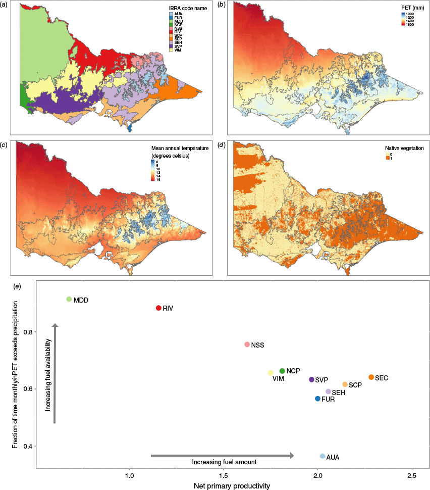
Here, we use IBRA (Interim Biogeographic Regionalisation for Australia) bioregions as our study areas. IBRA bioregions are geographically distinct entities, based on common climate, geology, landform, and native vegetation (Department of Sustainability, Environment, Water, Population and Communities 2013). We place these bioregions along a fuel- to climate-limited gradient using net primary productivity of native vegetation (Haverd et al. 2013) as an indication of potential fuel load, and the fraction of time monthly potential evapotranspiration (PET) exceeds precipitation (Boer et al. 2016) as a representation of climate dryness across their entire extent (Fig. 1). The bioregions vary from the most fuel-limited system, the Murray Darling Depression in the north-west, to the most climate-limited systems of the Australian Alps and the South East Corner with associated differences in their respective fire regimes (Table 1). The observed gradients of fire activity range from infrequent low to medium intensity shrub, litter or grass fires in the spring and summer at the fuel-limited end of the gradient (Murphy et al. 2013). Compared to very infrequent high intensity crown fires in summer at the most climate-limited end of the gradient (Table 1).
| Region | Dominant native vegetation (Environment Australia 2000) | Typical fire regime (Murphy et al. 2013) | Bioregion extent in Victoria (ha) | Native vegetation (%) | |
|---|---|---|---|---|---|
| Murray Darling Depression (MDD) | Semi-arid woodlands of Black Oak/Belah, Bullock Bush/Rosewood and Acacia spp., mallee shrublands and heathlands and savanna woodlands | Infrequent medium-intensity shrub fires in spring and summer | 6,353,401 | 38 | |
| Riverina (RIV) | River red gum and black box forests, box woodlands, saltbush shrublands, extensive grasslands and swamp communities | Infrequent low-intensity litter fires in spring and medium-intensity grass fires in summer | 2,501,323 | 31 | |
| NSW South Western Slopes (NSS) | Wet/damp sclerophyll forests, peppermint forests and box/ironbark woodlands | Infrequent low-intensity litter fires in spring and medium-intensity grass fires in summer | 567,828 | 47 | |
| Victorian Midlands (VIM) | Box Ironbark Woodland in Victoria, as well as substantial areas of Eucalyptus forests and woodlands with a grassy ground layer | Infrequent low-intensity litter fires in spring and medium-intensity grass fires in summer | 3,469,788 | 50 | |
| Naracoorte Coastal Plain (NCP) | Heathy woodlands and mallee shrublands with wet heaths in the inter-dune swales | Infrequent medium-intensity shrub fires in spring and summer | 420,534 | 50 | |
| Southern Volcanic Plain (SVP) | Open areas of grasslands, small patches of open woodland, stony rises denoting old lava flows, with many large shallow lakes with extensive wetlands | Infrequent low-intensity litter fires in spring and medium-intensity grass fires in summer | 2,355,581 | 15 | |
| Furneaux (FUR) | Wet Forest, Granitic Hills Woodland, Lowland Forest, Shrubby Foothill Forest and Damp Forest ecosystems with heathland and scrub ecosystems on more sandy soils | Infrequent low-intensity litter fires in spring and medium-intensity shrub fires in spring and summer | 39,806 | 99 | |
| South Eastern Highlands (SEH) | Wet and dry sclerophyll forests, woodland, minor cool temperate rainforest and minor grassland and herbaceous communities | Mix of infrequent low-intensity litter fires in spring and medium-intensity shrub fires in spring and summer and very infrequent high-intensity crown fires in summer | 3,250,505 | 82 | |
| South East Coastal Plain (SCP) | Mix of lowland forests, open forests with shrubby or heathy understoreys, grasslands and grassy woodlands, heathlands, shrublands, freshwater and coastal wetlands, mangrove scrubs, saltmarshes, dune scrubs and coastal tussock grasslands | Infrequent low-intensity litter fires in spring and medium-intensity shrub fires in spring and summer | 1,714,532 | 28 | |
| Australian Alps (AUA) | Alpine herbfields, and other treeless communities, snow gum woodlands and montane forests dominated by alpine ash | Infrequent low-intensity litter fires in spring and medium-intensity shrub fires in spring and summer | 714,460 | 99 | |
| South East Corner (SEC) | High elevation woodlands, wet and damp sclerophyll forests interspersed with rain-shadow woodlands in the Snowy River Valley. Lowland and coastal sclerophyll forests, woodlands, warm temperate rainforest and coastal communities occur in the lower areas | Very infrequent high-intensity crown fires in summer | 1,321,457 | 92 |
Fuel hazard data
Fuel hazard ratings were used to represent fuel load and structure. The fuel-hazard models used in this study were developed by McColl-Gausden et al. (2020) using an extensive database of field-based fuel hazard assessments across south-eastern Australia. The model predicts Fuel Hazard ratings as defined by the Overall Fuel Hazard Assessment Guide (McCarthy et al. 1999; Department for Environment and Heritage 2006; Hines et al. 2010) using environmental variables known to influence the distribution of vegetation (climatic, edaphic, fire history), thereby avoiding reliance on categorical vegetation classes, which are not always reliably mapped (Applestein and Germino 2022) and may mask fine scale variability in vegetation (Dorph et al. 2021). In the field, a fuel hazard rating is applied to each fuel strata on the basis of visually assessed attributes such as the horizontal and vertical continuity of the fine fuels in that stratum, and relate to the chance that a wildfire cannot be controlled (Hines et al. 2010). Fuel hazard ratings are predicted by the model for each of the four fuel strata, as defined in Hines et al. (2010): (1) surface; (2) near-surface; (3) elevated; and (4) bark. All fuel measurements are based on fine fuel, which is defined as readily combustible dead plant material <6 mm thick, and live plant material <3 mm thick with horizontal and vertical continuity. Surface fuel are predominately fine fuels lying on the ground; i.e. leaf litter, twigs, and detached bark. Near-surface fuels are connected to the ground, but not lying on it; i.e. grasses. Elevated fuel has a distinct gap between the ground and the fine fuel i.e. shrubs. In the field, these ratings are based on visual assessments and classification tables that integrate attributes relating to percentage cover, percentage of dead fuel, and the horizontal and vertical fuel continuity to assign each fuel stratum with a rating from 1 to 5, representing low, moderate, high, very high, and extreme fuel hazard, respectively).
The fuel model is described in detail by McColl-Gausden et al. (2020), and we provide an overview here. In brief, the model uses Random Forests to predict fuel hazard ratings per strata from seven predictors based on three climatic predictors (annual mean temperature ‘bio1’, maximum temperature of the warmest month ‘bio5’, and precipitation of the warmest quarter ‘bio18’), three edaphic predictors (surface soil bulk density, clay content, pH), and time since last prescribed fire or wildfire in years. The fuel hazard data used to develop the model were from field assessments conducted between 1995 and 2017, primarily in Victoria, but also from neighbouring states. The model’s development involved using the Random Forest algorithm to fit 500 classification trees for hazard ratings per fuel stratum. Model error rates (indicated by the proportion of records incorrectly classified) were consistently between 0.30 and 0.38 based on both Out-of-bag error and k-fold cross validation (k = 10; Hastie et al. 2009).
Fuel hazard predictions in this study used climatic variables from the NARCliM1.5 dataset (Nishant et al. 2021; Ji et al. 2022), see ‘Climate models’ section, along with static predictions of soil variables from the CSIRO Data Access Portal at a resolution of 3 × 3 arc-seconds (~90 m; https://esoil.io/TERNLandscapes/Public/Pages/SLGA/ accessed June 2024). All predictions assumed the same fire history and associated time since fire as of July 2019. These estimates incorporated the entire recorded fire history from 1970 to 1 July 2019. This time period was chosen to remove any undue influence from the extensive wildfires that occurred in eastern Victoria during the ‘Black Summer’ of January–February 2020 (Filkov et al. 2020). Fire history data were provided by the Victorian Department of Energy, Environment and Climate Action (DEECA) and are available at: data.services.vic.gov.au. The model produces spatial layers of hazard per fuel strata within the extant native vegetation of Victoria.
Fuel availability
Vegetation must be available to burn to act as fuel in a fire. Dead fine fuels are of particular importance to fire spread and intensity (Sullivan 2009) so predicting the moisture content is an important aspect of fire behaviour prediction. We selected vapour pressure deficit (VPD) as our proxy for fuel availability as previous research in Australian temperate ecosystems has shown that VPD is a good predictor of dead fine fuel moisture, and is robust across species and canopy densities including sites with low leaf area index (Resco de Dios et al. 2015; Nolan et al. 2016b; Cawson et al. 2024).
To calculate VPD, we calculated saturation vapour pressure from the temperature at 15:00 hours using the Tetens equation (Eqn 1) (Tetens 1930). From saturation pressure we were able to calculate VPD using relative humidity at 15:00 hours (Eqn 2). The time of 15:00 hours was selected as it typically represents some of the most dangerous fire weather conditions. Temperature and relative humidity data were from the NARCliM1.5 gridded climate projections (Ji et al. 2022), see ‘Climate Models’ section. For every fire season (from 1 November to 31 March), we selected the maximum temperature and the minimum relative humidity at 15:00 hours for each cell within each IBRA region, i.e. all land uses not just native vegetation, to examine changes in the extremes of VPD under changing climates, here termed VPD1500.
where es = saturation vapour pressure (KPa), and temp = temperature (°C).
where vpd = vapour pressure deficit (KPa), and rh = relative humidity (%).
Climate models
Annual cell-by-cell predictions of fuel hazard ratings and VPD were made using six different future climate projections for the period 2080–2099 to represent ‘future climate’ and between 2020 and 2039 to represent ‘current climate’ prediction. The climate data were from the NARCLIM1.5 project (Nishant et al. 2021; Ji et al. 2022). NARCLiM1.5 contains three global climate models (GCMs): (1) CCCMA CanESM2; (2) CSIRO ACCESS1-0; and (3) CSIRO ACCESS1-3. Each GCM has been downscaled to a grid size of 10 km using two regional climate models (RCMs), which better represent features important for local and regional weather and fire behaviour such as topography and coastlines. The resulting six-member NARCliM ensemble was selected to represent a wide range of possible climate futures. In the different bioregions, increases in annual mean temperature range from 2.0°C in the Southern Volcanic Plain under the CanESM2 model to 4.9°C in NSW South Western Slopes under the ACCESS1-3 model (current versus future climate) and changes in annual mean precipitation range from -48% in Naracoorte Coastal Plain under the ACCESS1-3 model to +22% in South East Corner under the CanESM2 model (see Supplementary Fig. S1).
Analysis
We examined how change in climate, as represented by the difference between 2020–2039 and 2080–2099 climate projections for each of the six climate models, influenced fuel hazard and VPD distributions. We used the fuel model to predict fuel hazard in native vegetation for surface, near-surface, elevated and bark strata at a resolution of ~250 m for the time periods 2020–2039 for ‘current climate’ and between 2080 and 2099 for ‘future climate.’ We then compared the number of hectares assigned to each hazard class for each time period, bioregion and climate model.
We calculate VPD1500 for each 10 km2 cell across all land use types in the bioregions for every fire season within the two climate periods: (1) 2020–2039; and (2) 2080–2099. We then compared the variation in values for each time period, bioregion and climate model.
All analyses were undertaken in R ver. 4.2.0 (R-Development Core Team 2022) with the terra, sf, dplyr, and ggplot2 packages (Wickham 2016; Pebesma 2018; Hijmans 2023; Wickham et al. 2023).
Results
Shifts in fuel hazard varied between strata and regions. Overall, some of the largest changes in fuel hazard were predicted for bioregions in the middle of the fuel- to climate-limited gradient under the warmest and driest models (i.e. Victorian midlands and the Naracoorte Coastal Plain; CSIRO ACCESS-1-3). In these cases, surface fuel hazard ratings decreased and elevated and near-surface ratings increased. This contributed to very high or extreme fuel hazard by 2080–2099 (Fig. 2; Figs S2–S6).
Percent change between current and future climates in the number of ha predicted to be at each fuel hazard rating per bioregion and fuel strata using the ACCESS1_3 R1 climate model. 1 = Low hazard, 2 = moderate hazard, 3 = high hazard, 4 = very high hazard, 5 = extreme hazard. Bioregions from top to bottom are ranked from most fuel-limited to most climate-limited, abbreviations: RIV, Riverina; NSS, NSW South Western Slopes; VIM, Victorian Midlands; NCP, Naracoorte Coastal Plain; SVP, Southern Volcanic Plain; FUR, Furneaux; SHE, South Eastern Highlands; SCP, South East Coastal Plain; AUA, Australian Alps; SEC, South East Corner.
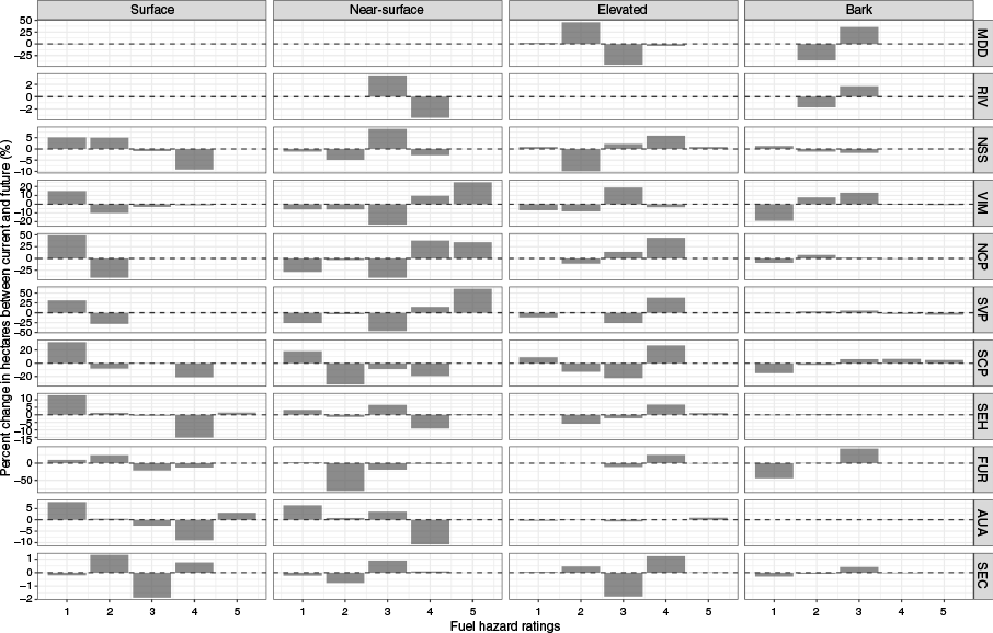
There was a shift towards lower fuel hazard ratings in the elevated fuel under five of the six climate models in the most fuel-limited system, the Murray Darling Depression, with mixed changes in the bark strata and minimal changes in all other fuel strata (Fig. 2; Figs S2–S6). The distribution of near-surface fuel hazards also decreased in the Riverina, the second most fuel-limited region, under five climate models (CSIRO ACCESS-1-3 R1, CSIRO ACCESS-1-3 R2, CSIRO ACCESS1-0 R2, CSIRO ACCESS1_0_R1 and CCCma_R1- Fig. 2; Figs S2, S4, S5, and S6) and increased under the other climate model.
In the more climate-limited systems such as the Australian Alps and the South East Corner, there were minimal predicted changes in fuel hazard ratings apart from a decrease in near-surface and surface fuel predicted in the Australian Alps and Furneaux (Fig. 2; Fig. S5).
There was a universal increase in the VPD values predicted for each of the bioregions under the hottest and driest climate models, CSIRO ACCESS-1-3 (R1 and R2). The mean VPD1500 value under the CSIRO ACCESS-1_3 R1 model increased under future climates with the average VPD1500 increasing from 6.0 to 6.5 in the most fuel-limited region, the Murray Darling Depression, and from 3.2 to 3.6 in the most climate-limited region, the South East Corner. Furneaux (towards the climate-limited end of the gradient) had the least change in predicted VPD1500 (Fig. 3).
The smoothed density estimate of the histogram of VPD1500 values across each IBRA bioregion. The purple distribution are the values predicted in the fire season between 2020 and 2039 and the orange distribution are the values predicted in the fire season between 2080 and 2099 under the ACCESS1_3_R1 climate model. The dashed lines represent the mean value within each distribution. Bioregions from top to bottom are ranked from most fuel-limited to most climate-limited, abbreviations: RIV, Riverina; NSS, NSW South Western Slopes; VIM, Victorian Midlands; NCP, Naracoorte Coastal Plain; SVP, Southern Volcanic Plain; FUR, Furneaux; SHE, South Eastern Highlands; SCP, South East Coastal Plain; AUA, Australian Alps; SEC, South East Corner.
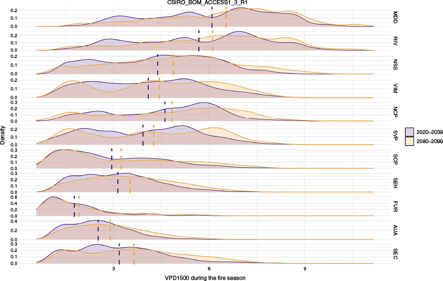
Under the CCCMA CanESM2 models, which typically predicted small increases in both annual rainfall and temperature (Fig. S1), there was a predicted increase in VPD1500 in the most fuel-limited systems (Murray Darling Depression, Riverina, and NSW South Western Slopes), with a decrease or no change for the remaining regions under the R1 downscaled version (Fig. S7), but a universal increase in VPD1500 under the R2 downscaled version (Fig. S8). We saw a similar increase in VPD under the CSIRO ACCESS-1_0 models in the more fuel-limited systems (Murray Darling Depression and Riverina) but limited changes or a decrease in VPD1500 for the remaining regions under both downscaled models (Figs S9, S10).
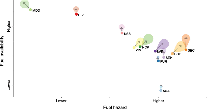
Overall, the biggest shifts in both hazard and fuel availability (VPD) occurred in those regions closer to the middle of the fuel- to climate- limited gradient (Fig. 4). Increases in both fuel hazard and VPD were predicted for the Victorian Midland, Naracoorte Coastal Plain, and the Southern Volcanic Plain. Small increases in VPD were predicted for the Furneaux region, South Eastern Highlands and Australian Alps (Fig. 4). At the fuel limited end, a decrease or no change in fuel hazard, but an increase in VPD was predicted for the Murray Darling Depression, Riverina, and the NSW South Western Slopes (Fig. 4). At the most climate-limited end, increases in both VPD and fuel hazard were predicted for the South East Coastal Plain, and an increase in VPD with no change in fuel hazard was predicted for the South East Corner (Fig. 4).
Conceptual direction of change for each IBRA bioregion in terms of fuel hazard and fuel availability under the warmest and driest climate models: CSIRO ACCESS1-3. The size of the arrow and shaded areas are based on the direction and strength of the predicted changes to both VPD1500 and fuel hazard across all strata. The fuel- to climate-limited gradient moves from top left to bottom right. Abbreviations: RIV, Riverina; NSS, NSW South Western Slopes; VIM, Victorian Midlands; NCP, Naracoorte Coastal Plain; SVP, Southern Volcanic Plain; FUR, Furneaux; SHE, South Eastern Highlands; SCP, South East Coastal Plain; AUA, Australian Alps; SEC, South East Corner.
Discussion
Climate change is already impacting fire regimes, driving large departures from historical patterns (Collins et al. 2022; Lane et al. 2023). Our use of biophysical models alongside climate projections to predict changes in fuel hazard and availability driven by climatic change can help identify where the greatest areas of fire risk may occur. By using a climate to fuel-limited gradient framework, we can identify where areas of fuel changes in native vegetation might be most or least likely to cause subsequent changes in the fire regime.
Changes in fuel hazard (representing load and structure), while potentially influencing fire behaviour in all systems, will be most important in fuel-limited systems (Krawchuk and Moritz 2011). Any increases in fuel load or continuity could drive changes in the fire regime such as increases in fire frequency or intensity, while a decrease could conversely reduce frequency or intensity (Steel et al. 2015). We predicted a decrease in elevated fuel hazard for the most fuel-limited bioregion, the Murray Darling Depression, and no change in fuel hazard for the Riverina bioregion, the second-most fuel-limited bioregion. However, maximum VPD in these bioregions was predicted to increase (Fig. 4). Fire regimes in these bioregions in Victoria’s north-west are driven by infrequent high-intensity fires in spring following winter rains that promote grass growth (Greenville et al. 2009; Murphy et al. 2013). While our fuel hazard predictions indicate minimal changes in fuel patterns, the higher VPD values may increase the risk of fires starting and spreading on more days within the fire season.
The biggest change in fuel hazard and fuel availability occurred in the bioregions near the middle of the fuel to climate-limited gradient: Victorian Midlands; Naracoorte Coastal Plain; Southern Volcanic Plain; and South East Coastal Plain (Fig. 4). Native vegetation in these bioregions is typically combinations of grassy woodlands and dry eucalypt forests. The four bioregions were predicted to increase in elevated and near-surface fuel hazard, decrease in surface fuel, and increase in VPD1500 during the fire season under the warmest and driest climate models. While a reduction in surface fuel hazard may reduce the risk of initial fire spread (Sullivan et al. 2012), increases in fuel hazard within the other fuel strata may increase fire intensity associated with an increased likelihood of fire spread due to increased connectivity between fuel strata. The congruent predicted increase in VPD1500 increases the likelihood that fuel will be available to burn. Alongside the potential increases in lightning and anthropogenic ignitions (Clarke et al. 2019), this indicates increased future fire risks in these landscapes since any increases in fire frequency could increase the likelihood of greater damage to life and property given their relatively high human populations and complex wildland–urban interface (WUI) in an already fire-prone landscape (Harris et al. 2012; Penman et al. 2019).
In the eastern half of the State including the South East Corner bioregion, the wetter forests (wet and damp sclerophyll forests, warm temperate rainforests), typically burn infrequently usually after prolonged drought (Murphy et al. 2013; Cawson et al. 2020). Such wildfires can be extensive and lead to significant losses of property (Cruz et al. 2012; Filkov et al. 2020). The South East Corner was predicted to have limited to no changes in fuel hazard ratings; however, the predicted increase in VPD1500 suggests that these ecosystems may be available to burn more often. The occurrence of droughts is likely to increase in south-eastern Australia (Collins et al. 2022) resulting in an increased number of potentially dangerous fire seasons. Given the higher density of fire-killed canopy species in the eastern bioregions, such as Eucalyptus regnans and Eucalyptus delegatensis, there is also the potential for the compounding impacts of increasing aridity alongside tree mortality to increase the intensity of fire behaviour well beyond the capacity of fire suppression (Cary et al. 2017; Goodwin et al. 2021; Stephens et al. 2022).
Modelling considerations
Our forecasting of future fuel hazards was based on extrapolations of existing empirical relationships. That is, our modelling assumes that the relationships between climate, soil and time since fire with fuel hazard will continue to hold true over time. Implicit in the assumption is that vegetation life forms will have uniform responses to climate now and in the future. For example, if the climatic conditions for an elevated hazard value of extreme (high coverage of shrubs) shifts spatially within a landscape, it is assumed that a shrub species will be there to fill that niche. Furthermore, it ignores the potential of invasive native or non-native species to change structure, mass, and flammability of vegetation (Hill et al. 2005; Tran et al. 2008; Caracciolo et al. 2016; Pickering et al. 2022), including in positive feedback cycles whereby fire tolerant species promote more fire through their structural characteristics (Chambers et al. 2019; Landesmann et al. 2021).
We also acknowledge that our two proxies for change in fuel, VPD and fuel hazard, are both predictors of fine fuel components. That is, we do not attempt to predict changes to coarse fuel components which are generally defined as greater than 6 mm in diameter (Hines et al. 2010). However, we acknowledge the important role of coarse fuels in fire behaviour components such as flaming and smouldering duration (Cawson et al. 2021).
A future research direction could include dynamic vegetation modelling or landscape modelling (Keane et al. 2015) that provide a mechanistic means of forecasting future fuels, which can sometimes account for feedbacks between climate, vegetation, and fire. In this study, we focus on broad trends at the bioregion scale. However, there will be considerable fine-scale variation in fuel dynamics associated with the impacts of fire and local climate change that might be better captured via the coupling of vegetation dynamics models with fire regime models (Loehman et al. 2020). These models are capable of predicting changes for many species within vegetation communities, provided there are sufficient demographic, growth, and competition data available. However, the complexity of understorey will make this task extremely challenging for many of the native ecosystems of Victoria where more than 100 understorey species can coexist (Ough 2001; Penman et al. 2008; Cohn et al. 2015; Cawson et al. 2018; Chick et al. 2018). These models too are subject to input assumptions and may struggle to predict the complexity of our forest systems.
Forecasting future fuel as we have done here does not account for nonlinear behaviours and feedbacks between biophysical and human systems that are expected under climate change (Mayer and Khalyani 2011). Urban populations will continue to expand (Seto et al. 2012), and agricultural lands will change with technological change and adaptation to climate change (Moreira and Russo 2007; Martínez et al. 2009) leading to shifts in land-use patterns as well as changes in vegetation distributions and ignition likelihood across landscapes (Clarke et al. 2019). Furthermore, changes to land management such as cessation of commercial timber harvesting (Bennett et al. 2024) and renewal of Indigenous land management (Fletcher et al. 2021; Mariani et al. 2022) all have the potential to alter landscape fuel dynamics in ways that will vary with the intersections among vegetation type, management practices, climate and fire.
Global climatic change will alter landscape fuel patterns both in terms of fuel hazard (as structure and load) and fuel availability. Any changes will not be universal, and the impact of changes will vary depending on an ecosystems position on the fuel- to climate-limited gradient. The biggest potential changes to the fire regime occur in the regions near the middle of the gradient with increases in both fuel hazard and fuel availability with the potential to result in higher fire intensity and/or frequency. While the most climate-limited systems were predicted to have no changes in fuel hazard under the warmest and driest climate models, the increase in VPD may result in higher fire danger days and fuels being available to burn more often, increasing the likelihood of high severity wildfires.
Data availability
The fuel hazard data that support this study were obtained from between the Victorian Department of Energy, Environment and Climate Action by permission. Data will be shared upon reasonable request to the corresponding author with permission from the Victorian Department of Energy, Environment and Climate Action. The climate data that supported this study are available from https://datasets.seed.nsw.gov.au/dataset/narclim-climate-projections-n1-5 (accessed December 2024). Soil data are available from https://esoil.io/TERNLandscapes/Public/Pages/SLGA/ (accessed June 2024). All other environmental variables can be found at data.vic.gov.au.
Conflicts of interest
H. Clarke is an Associate Editor of the International Journal of Wildland Fire but was not involved in the peer review or any decision-making process for this paper. The authors declare no other conflicts of interest.
Declaration of funding
This research was supported by the Integrated Forest Ecosystem Research agreement between the Victorian Department of Energy, Environment and Climate Action and the University of Melbourne. HC receives funding from the Westpac Scholars Trust via a Westpac Research Fellowship.
Acknowledgements
We acknowledge the Traditional Owners of the land on which this study occurred – the Dja Dja Wurrung and Wurundjeri peoples.
References
Abram NJ, Henley BJ, Sen Gupta A, Lippmann TJR, Clarke H, Dowdy AJ, Sharples JJ, Nolan RH, Zhang T, Wooster MJ, Wurtzel JB, Meissner KJ, Pitman AJ, Ukkola AM, Murphy BP, Tapper NJ, Boer MM (2021) Connections of climate change and variability to large and extreme forest fires in southeast Australia. Communications Earth & Environment 2(1), 8.
| Crossref | Google Scholar |
Applestein C, Germino MJ (2022) How do accuracy and model agreement vary with versioning, scale, and landscape heterogeneity for satellite-derived vegetation maps in sagebrush steppe? Ecological Indicators 139, 108935.
| Crossref | Google Scholar |
Balik JA, Coop JD, Krawchuk MA, Naficy CE, Parisien M-A, Parks SA, Stevens-Rumann CS, Whitman E (2024) Biogeographic patterns of daily wildfire spread and extremes across North America. Frontiers in Forests and Global Change 7, 1355361.
| Crossref | Google Scholar |
Bennett LT, Fairman TA, Ford RM, Keenan RJ, Fletcher MS, Nitschke CR (2024) Active management: a definition and considerations for implementation in forests of temperate Australia. Australian Forestry 87(3), 125-147.
| Crossref | Google Scholar |
Boer MM, Bowman DMJS, Murphy BP, Cary GJ, Cochrane MA, Fensham RJ, Krawchuk MA, Price OF, De Dios VR, Williams RJ, Bradstock RA (2016) Future changes in climatic water balance determine potential for transformational shifts in Australian fire regimes. Environmental Research Letters 11(6), 065002.
| Crossref | Google Scholar |
Bradstock R (2010) A biogeographic model of fire regimes in Australia: current and future implications. Global Ecology and Biogeography 19, 145-158.
| Crossref | Google Scholar |
Caracciolo D, Istanbulluoglu E, Noto LV, Collins SL (2016) Mechanisms of shrub encroachment into Northern Chihuahuan Desert grasslands and impacts of climate change investigated using a cellular automata model. Advances in Water Resources 91, 46-62.
| Crossref | Google Scholar |
Cary GJ, Davies ID, Bradstock RA, Keane RE, Flannigan MD (2017) Importance of fuel treatment for limiting moderate-to-high intensity fire: findings from comparative fire modelling. Landscape Ecology 32(7), 1473-1483.
| Crossref | Google Scholar |
Cawson JG, Duff TJ, Swan MH, Penman TD (2018) Wildfire in wet sclerophyll forests: the interplay between disturbances and fuel dynamics. Ecosphere 9(5), e02211.
| Crossref | Google Scholar |
Cawson JG, Hemming V, Ackland A, Anderson W, Bowman D, Bradstock R, Brown TP, Burton J, Cary GJ, Duff TJ, Filkov A, Furlaud JM, Gazzard T, Kilinc M, Nyman P, Peacock R, Ryan M, Sharples J, Sheridan G, Tolhurst K, Wells T, Zylstra P, Penman TD (2020) Exploring the key drivers of forest flammability in wet eucalypt forests using expert-derived conceptual models. Landscape Ecology 35(8), 1775-1798.
| Crossref | Google Scholar |
Cawson JG, Pickering B, Penman TD, Filkov A (2021) Quantifying the effect of mastication on flaming and smouldering durations in eucalypt forests and woodlands under laboratory conditions. International Journal of Wildland Fire 30(8), 611-624.
| Crossref | Google Scholar |
Cawson JG, Burton JE, Pickering BJ, Penman TD (2024) Moisture thresholds for ignition vary between types of eucalypt forests across an aridity gradient. Landscape Ecology 39(3), 70.
| Crossref | Google Scholar |
Chambers JC, Brooks ML, Germino MJ, Maestas JD, Board DI, Jones MO, Allred BW (2019) Operationalizing resilience and resistance concepts to address invasive grass-fire cycles. Frontiers in Ecology and Evolution 7, 185.
| Crossref | Google Scholar |
Chick MP, Nitschke CR, Cohn JS, Penman TD, York A (2018) Factors influencing above-ground and soil seed bank vegetation diversity at different scales in a quasi-Mediterranean ecosystem. Journal of Vegetation Science 29(4), 684-694.
| Crossref | Google Scholar |
Clarke H, Gibson R, Cirulis B, Bradstock RA, Penman TD (2019) Developing and testing models of the drivers of anthropogenic and lightning-caused wildfire ignitions in south-eastern Australia. Journal of Environmental Management 235, 34-41.
| Crossref | Google Scholar |
Clarke H, Nolan RH, De Dios VR, Bradstock R, Griebel A, Khanal S, Boer MM (2022) Forest fire threatens global carbon sinks and population centres under rising atmospheric water demand. Nature Communications 13(1), 7161.
| Crossref | Google Scholar | PubMed |
Clarke H, Penman T, Boer M, Cary GJ, Fontaine JB, Price O, Bradstock R (2020) The proximal drivers of large fires: a pyrogeographic study. Frontiers in Earth Science 8, 90.
| Crossref | Google Scholar |
Cohn JS, Di Stefano J, Christie F, Cheers G, York A (2015) How do heterogeneity in vegetation types and post-fire age-classes contribute to plant diversity at the landscape scale? Forest Ecology and Management 346, 22-30.
| Crossref | Google Scholar |
Collins L, Clarke H, Clarke MF, McColl Gausden SC, Nolan RH, Penman T, Bradstock R (2022) Warmer and drier conditions have increased the potential for large and severe fire seasons across south-eastern Australia. Global Ecology and Biogeography 31(10), 1933-1948.
| Crossref | Google Scholar |
Cruz MG, Sullivan AL, Gould JS, Sims NC, Bannister AJ, Hollis JJ, Hurley RJ (2012) Anatomy of a catastrophic wildfire: the Black Saturday Kilmore East fire in Victoria, Australia. Forest Ecology and Management 284, 269-285.
| Crossref | Google Scholar |
Department for Environment and Heritage (2006) ‘Overall Fuel Hazard Guide for South Australia.’ 2nd edn. (Department of Environment and Natural Resources: Adelaide, SA) Available at https://cdn.environment.sa.gov.au/environment/docs/overall-fuel-hazard-guide-gen.pdf
Department of Sustainability, Environment, Water, Population and Communities (2013) Interim Biogeographic Regionalisation for Australia (IBRA), Version 7 (Regions). Bioregional Assessment Source Dataset. Available at https://fed.dcceew.gov.au/datasets/8f7e2436a6d5436ca001fa7f2aee3fd8/about
Devanand A, Falster GM, Gillett ZE, Hobeichi S, Holgate CM, Jin C, Mu M, Parker T, Rifai SW, Rome KS, Stojanovic M, Vogel E, Abram NJ, Abramowitz G, Coats S, Evans JP, Gallant AJE, Pitman AJ, Power SB, Rauniyar SP, Taschetto AS, Ukkola AM (2024) Australia’s Tinderbox drought: an extreme natural event likely worsened by human-caused climate change. Science Advances 10(10), eadj3460.
| Crossref | Google Scholar | PubMed |
Dorph A, Swan M, Di Stefano J, Penman TD (2021) Relating mammal species richness to landscape patterns across multiple spatial scales. Landscape Ecology 36(4), 1003-1022.
| Crossref | Google Scholar |
Emergency Management Victoria (2018) ‘Bushfire Fuel Management Guide For the protection of townships and settlements.’ (Melbourne, Vic) Available at https://www.safertogether.vic.gov.au/__data/assets/pdf_file/0016/409120/Bushfire-Fuel-Management-Guide-Final-10th-May-2018.pdf
Environment Australia (2000) ‘Revision of the Interim Biogeographic Regionalisation of Australia (IBRA) and the Development of Version 5.1. - Summary Report.’ (Canberra) Available at https://www.dcceew.gov.au/environment/land/nrs/publications/revision-ibra-development-of-version-5-1-summary-report
Filkov AI, Ngo T, Matthews S, Telfer S, Penman TD (2020) Impact of Australia’s catastrophic 2019/20 bushfire season on communities and environment. Retrospective analysis and current trends. Journal of Safety Science and Resilience 1(1), 44-56.
| Crossref | Google Scholar |
Fletcher M-S, Romano A, Connor S, Mariani M, Maezumi SY (2021) Catastrophic bushfires, Indigenous fire knowledge and reframing science in southeast Australia. Fire 4(3), 61.
| Crossref | Google Scholar |
Francis EJ, Pourmohammadi P, Steel ZL, Collins BM, Hurteau MD (2023) Proportion of forest area burned at high-severity increases with increasing forest cover and connectivity in western US watersheds. Landscape Ecology 38(10), 2501-2518.
| Crossref | Google Scholar |
Goodwin MJ, Zald HSJ, North MP, Hurteau MD (2021) Climate-driven tree mortality and fuel aridity increase wildfire’s potential heat flux. Geophysical Research Letters 48(24), e2021GL094954.
| Crossref | Google Scholar |
Greenville AC, Dickman CR, Wardle GM, Letnic M (2009) The fire history of an arid grassland: the influence of antecedent rainfall and ENSO. International Journal of Wildland Fire 18(6), 631-639.
| Crossref | Google Scholar |
Harris S, Anderson W, Kilinc M, Fogarty L (2012) The relationship between fire behaviour measures and community loss: an exploratory analysis for developing a bushfire severity scale. Natural Hazards 63(2), 391-415.
| Crossref | Google Scholar |
Haverd V, Raupach MR, Briggs PR, Canadell JG, Davis SJ, Law RM, Meyer CP, Peters GP, Pickett-Heaps C, Sherman B (2013) The Australian terrestrial carbon budget. Biogeosciences 10(2), 851-869.
| Crossref | Google Scholar |
Higuera PE, Abatzoglou JT (2021) Record-setting climate enabled the extraordinary 2020 fire season in the western United States. Global Change Biology 27(1), 1-2.
| Crossref | Google Scholar |
Hijmans RJ (2023) terra: Spatial Data Analysis. Available at https://cran.r-project.org/web/packages/terra/index.html
Hill MJ, Roxburgh SH, Carter JO, McKeon GM (2005) Vegetation state change and consequent carbon dynamics in savanna woodlands of Australia in response to grazing, drought and fire: a scenario approach using 113 years of synthetic annual fire and grassland growth. Australian Journal of Botany 53(7), 715-739.
| Crossref | Google Scholar |
Hines F, Tolhurst KG, Wilson AA, McCarthy GJ (2010) Overall fuel hazard assessment guide. In ‘Fire and adaptive management’. 4th edn July 2010 edn. (Victorian Government: Melbourne) Available at https://www.ffm.vic.gov.au/__data/assets/pdf_file/0005/21110/Report-82-overall-fuel-assess-guide-4th-ed.pdf
Hurteau MD, Liang S, Westerling AL, Wiedinmyer C (2019) Vegetation-fire feedback reduces projected area burned under climate change. Scientific Reports 9(1), 2838.
| Crossref | Google Scholar | PubMed |
Ji F, Nishant N, Evans JP, Di Virgilio G, Cheung KKW, Tam E, Beyer K, Riley ML (2022) Introducing NARCliM1.5: evaluation and projection of climate extremes for southeast Australia. Weather and Climate Extremes 38, 100526.
| Crossref | Google Scholar |
Keane RE, McKenzie D, Falk DA, Smithwick EAH, Miller C, Kellogg L-KB (2015) Representing climate, disturbance, and vegetation interactions in landscape models. Ecological Modelling 309-310, 33-47.
| Crossref | Google Scholar |
King KJ, Cary GJ, Bradstock RA, Marsden-Smedley JB (2013) Contrasting fire responses to climate and management: insights from two Australian ecosystems. Global Change Biology 19(4), 1223-1235.
| Crossref | Google Scholar | PubMed |
Krawchuk MA, Moritz MA (2011) Constraints on global fire activity vary across a resource gradient. Ecology 92(1), 121-132.
| Crossref | Google Scholar | PubMed |
Landesmann JB, Tiribelli F, Paritsis J, Veblen TT, Kitzberger T (2021) Increased fire severity triggers positive feedbacks of greater vegetation flammability and favors plant community-type conversions. Journal of Vegetation Science 32(1), e12936.
| Crossref | Google Scholar |
Lane TP, King AD, Perkins-Kirkpatrick SE, Pitman AJ, Alexander LV, Arblaster JM, Bindoff NL, Bishop CH, Black MT, Bradstock RA, Clarke HG, Gallant AJE, Grose MR, Holbrook NJ, Holland GJ, Hope PK, Karoly DJ, Raupach TH, Ukkola AM (2023) Attribution of extreme events to climate change in the Australian region – A review. Weather and Climate Extremes 42, 100622.
| Crossref | Google Scholar |
Littell JS, McKenzie D, Peterson DL, Westerling AL (2009) Climate and wildfire area burned in western U.S. ecoprovinces, 1916–2003. Ecological Applications 19(4), 1003-1021.
| Crossref | Google Scholar |
Littell JS, McKenzie D, Wan HY, Cushman SA (2018) Climate change and future wildfire in the western United States: an ecological approach to nonstationarity. Earth’s Future 6(8), 1097-1111.
| Crossref | Google Scholar |
Loehman RA, Keane RE, Holsinger LM (2020) Simulation modeling of complex climate, wildfire, and vegetation dynamics to address wicked problems in land management. Frontiers in Forests and Global Change 3, 3.
| Crossref | Google Scholar |
Loepfe L, Martinez-Vilalta J, Oliveres J, Piñol J, Lloret F (2010) Feedbacks between fuel reduction and landscape homogenisation determine fire regimes in three Mediterranean areas. Forest Ecology and Management 259(12), 2366-2374.
| Crossref | Google Scholar |
Mariani M, Connor SE, Theuerkauf M, Herbert A, Kuneš P, Bowman D, Fletcher M-S, Head L, Kershaw AP, Haberle SG, Stevenson J, Adeleye M, Cadd H, Hopf F, Briles C (2022) Disruption of cultural burning promotes shrub encroachment and unprecedented wildfires. Frontiers in Ecology and the Environment 20, 292-300.
| Crossref | Google Scholar |
Marshall E, Keem JL, Penman TD, Di Stefano J (2025) Simulating fuel management for protecting regional biodiversity under climate change. Journal of Environmental Management 373, 123731.
| Crossref | Google Scholar |
Martínez J, Vega-Garcia C, Chuvieco E (2009) Human-caused wildfire risk rating for prevention planning in Spain. Journal of Environmental Management 90(2), 1241-1252.
| Crossref | Google Scholar | PubMed |
Mayer AL, Khalyani AH (2011) Grass trumps trees with fire. Science 334(6053), 188-189.
| Crossref | Google Scholar | PubMed |
McCarthy GJ, Tolhurst KG, Chatto K (1999) ‘Overall Fuel Hazard Guide.’ (Department of Natural Resources and Environment: Melbourne) Available at https://www.ffm.vic.gov.au/__data/assets/pdf_file/0014/21056/Report-47-Overall-Fuel-Hazard-Guide.pdf
McColl-Gausden SC, Bennett LT, Duff TJ, Cawson JG, Penman TD (2020) Climatic and edaphic gradients predict variation in wildland fuel hazard in south-eastern Australia. Ecography 43(3), 443-455.
| Crossref | Google Scholar |
McColl-Gausden SC, Bennett LT, Clarke HG, Ababei DA, Penman TD (2022) The fuel–climate–fire conundrum: How will fire regimes change in temperate eucalypt forests under climate change? Global Change Biology 28(17), 5211-5226.
| Crossref | Google Scholar |
McKenzie D, Littell JS (2017) Climate change and the eco-hydrology of fire: will area burned increase in a warming western USA? Ecological Applications 27(1), 26-36.
| Crossref | Google Scholar | PubMed |
Moreira F, Russo D (2007) Modelling the impact of agricultural abandonment and wildfires on vertebrate diversity in Mediterranean Europe. Landscape Ecology 22(10), 1461-1476.
| Crossref | Google Scholar |
Murphy BP, Bradstock RA, Boer MM, Carter J, Cary GJ, Cochrane MA, Fensham RJ, Russell-Smith J, Williamson GJ, Bowman DJMS (2013) Fire regimes of Australia: a pyrogeographic model system. Journal of Biogeography 40(6), 1048-1058.
| Crossref | Google Scholar |
Nishant N, Evans JP, Di Virgilio G, Downes SM, Ji F, Cheung KKW, Tam E, Miller J, Beyer K, Riley ML (2021) Introducing NARCliM1.5: evaluating the performance of regional climate projections for southeast Australia for 1950–2100. Earth’s Future 9(7), e2020EF001833.
| Crossref | Google Scholar |
Nolan RH, Boer MM, Resco de Dios V, Caccamo G, Bradstock RA (2016a) Large-scale, dynamic transformations in fuel moisture drive wildfire activity across southeastern Australia. Geophysical Research Letters 43(9), 4229-4238.
| Crossref | Google Scholar |
Nolan RH, Resco de Dios V, Boer MM, Caccamo G, Goulden ML, Bradstock RA (2016b) Predicting dead fine fuel moisture at regional scales using vapour pressure deficit from MODIS and gridded weather data. Remote Sensing of Environment 174, 100-108.
| Crossref | Google Scholar |
Nolan RH, Boer MM, Collins L, Resco de Dios V, Clarke H, Jenkins M, Kenny B, Bradstock RA (2020) Causes and consequences of eastern Australia’s 2019–20 season of mega-fires. Global Change Biology 26(3), 1039-1041.
| Crossref | Google Scholar |
Ough K (2001) Regeneration of Wet Forest flora a decade after clear-felling or wildfire - is there a difference? Australian Journal of Botany 49, 645-664.
| Crossref | Google Scholar |
Parks SA, Parisien M-A, Miller C, Dobrowski SZ (2014) Fire activity and severity in the western us vary along proxy gradients representing fuel amount and fuel moisture. PLoS One 9(6), e99699.
| Crossref | Google Scholar | PubMed |
Pausas JG, Ribeiro E (2013) The global fire–productivity relationship. Global Ecology and Biogeography 22(6), 728-736.
| Crossref | Google Scholar |
Pebesma E (2018) Simple features for R: standardized support for spatial vector data. The R Journal 10(1), 439-446.
| Crossref | Google Scholar |
Penman TD, Binns DL, Shiels RJ, Allen RM, Kavanagh RP (2008) Changes in understorey plant species richness following logging and prescribed burning in shrubby dry sclerophyll forests of south-eastern Australia. Austral Ecology 33(2), 197-210.
| Crossref | Google Scholar |
Penman SH, Price OF, Penman TD, Bradstock RA (2019) The role of defensible space on the likelihood of house impact from wildfires in forested landscapes of south eastern Australia. International Journal of Wildland Fire 28(1), 4-14.
| Crossref | Google Scholar |
Pickering BJ, Burton JE, Penman TD, Grant MA, Cawson JG (2022) Long-term response of fuel to mechanical mastication in south-eastern Australia. Fire 5, 76.
| Crossref | Google Scholar |
Price OF, Penman TD, Bradstock RA, Boer MM, Clarke H (2015) Biogeographical variation in the potential effectiveness of prescribed fire in south-eastern Australia. Journal of Biogeography 42(11), 2234-2245.
| Crossref | Google Scholar |
R-Development Core Team (2022) ‘R: A language and environment for statistical computing.’ (R Foundation for Statistical Computing: Vienna, Austria) Available at http://www.R-project.org
Ren J, Hanan EJ, Abatzoglou JT, Kolden CA, Tague CL, Kennedy MC, Liu M, Adam JC (2022) Projecting future fire regimes in a semiarid watershed of the inland northwestern United States: interactions among climate change, vegetation productivity, and fuel dynamics. Earth’s Future 10(3), e2021EF002518.
| Crossref | Google Scholar |
Resco de Dios V, Fellows AW, Nolan RH, Boer MM, Bradstock RA, Domingo F, Goulden ML (2015) A semi-mechanistic model for predicting the moisture content of fine litter. Agricultural and Forest Meteorology 203, 64-73.
| Crossref | Google Scholar |
Rodrigues M, Resco de Dios V, Sil Â, Cunill Camprubí À, Fernandes PM (2024) VPD-based models of dead fine fuel moisture provide best estimates in a global dataset. Agricultural and Forest Meteorology 346, 109868.
| Crossref | Google Scholar |
Seto KC, Güneralp B, Hutyra LR (2012) Global forecasts of urban expansion to 2030 and direct impacts on biodiversity and carbon pools. Proceedings of the National Academy of Sciences of the United States of America 109(40), 16083-16088.
| Crossref | Google Scholar | PubMed |
Setterfield SA, Rossiter-Rachor NA, Douglas MM, Wainger L, Petty AM, Barrow P, Shepherd IJ, Ferdinands KB (2013) Adding fuel to the fire: the impacts of non-native grass invasion on fire management at a regional scale. PLoS One 8(5), e59144.
| Crossref | Google Scholar | PubMed |
Steel ZL, Safford HD, Viers JH (2015) The fire frequency-severity relationship and the legacy of fire suppression in California forests. Ecosphere 6(1), 8.
| Crossref | Google Scholar |
Stegen JC, Swenson NG, Enquist BJ, White EP, Phillips OL, Jørgensen PM, Weiser MD, Monteagudo Mendoza A, Núñez Vargas P (2011) Variation in above-ground forest biomass across broad climatic gradients. Global Ecology and Biogeography 20(5), 744-754.
| Crossref | Google Scholar |
Stephens SL, Bernal AA, Collins BM, Finney MA, Lautenberger C, Saah D (2022) Mass fire behavior created by extensive tree mortality and high tree density not predicted by operational fire behavior models in the southern Sierra Nevada. Forest Ecology and Management 518, 120258.
| Crossref | Google Scholar |
Sullivan AL (2009) Wildland surface fire spread modelling, 1990-2007. 2: Empirical and quasi-empirical models. International Journal of Wildland Fire 4, 369-386.
| Crossref | Google Scholar |
Sullivan AL, McCaw WL, Cruz MG, Matthews S, Ellis PF (2012) Fuel, fire weather and fire behaviour in Australian Ecosystems. In ‘Flammable Australia: Fire Regimes, Biodiversity and Ecosystems in a Changing World’. (Eds RA Bradstock, AM Gill, RJ Williams) pp. 51–78. (CSIRO Publishing: Melbourne, Vic, Australia)
Tetens O (1930) Uber einige meteorologische Begriff. Zeitschrift fur Geophysik 6, 297-309 [In German].
| Google Scholar |
Tran C, Gilroy J, Williams PR (2008) Quantifying the fuel load and fire hazard in a wet sclerophyll community of southeast Queensland, following invasion by the woody weed Lantana camara. In ‘Proceedings of FIRE2008 International Fire Congress’, 3–6 September 2008, Adelaide, Australia. p. 11. (Australasian Fire Association Council and Bushfire Cooperative Research Centre: Melbourne, Vic)
Victorian Government Department of Sustainability and Environment (2011) ‘Victoria's Native Vegetation Management: A Framework for Action.’ (Victorian Government Department of Natural Resources and Environment: Melbourne, Vic) Available at https://www.environment.vic.gov.au/__data/assets/pdf_file/0021/90363/Native_Vegetation_Management_-_A_Framework_for_Action.pdf
Westerling AL, Gershunov A, Brown TJ, Cayan DR, Dettinger MD (2003) Climate and Wildfire in the Western United States. Bulletin of the American Meteorological Society 84(5), 595-604.
| Crossref | Google Scholar |
Wickham H (2016) ggplot2: Elegant Graphics for Data Analysis. Available at https://link.springer.com/book/10.1007/978-0-387-98141-3
Wickham H, François R, Henry L, Müller K, Vaughan D (2023) dplyr: A Grammar of Data Manipulation, R package version 1.1.4. Available at https://cran.r-project.org/web/packages/dplyr/index.html