

Can the National Fire-Danger Rating System (NFDRS)-1978 of the United States be effective in other regions? Israel as a case study
Edna Guk A B , Avi Bar-Massada C and Noam Levin A D *
A
B
C
D
Abstract
Effective fire management requires reliable pre-fire risk assessment tools. The United States (US) National Fire-Danger Rating System (NFDRS)-1978 is widely used, yet its applicability in non-US ecosystems remains uncertain.
We retrospectively tested the effectiveness of the Burning Index (BI) in predicting wildfire characteristics in non-US Mediterranean-type ecosystems, using Israel as a case study.
We examined correlations between the BI and wildfire characteristics at multiple temporal scales and developed an enhanced predictive model by integrating the index with vegetation-related and anthropogenic variables.
The BI had stronger correlations with wildfire burned area at coarser temporal scales (monthly and weekly), whereas its correlative utility diminished at finer resolutions (daily and event-based scales). Incorporating additional data – such as live fuel moisture content (LFMC), vegetation continuity and anthropogenic factors – significantly enhanced model performance for burned area predictions, increasing the explained variance up to 50% when arson and military-related wildfires were excluded. In contrast, wildfire duration was not successfully predicted by either BI alone or the multivariable predictive model.
The BI’s predictive strength is scale-dependent and limited at fine resolutions.
Our results highlight the importance of accounting for the characteristics of the local fire regime when adapting the NFDRS for non-US ecosystems.
Keywords: burned area, burning index (BI), fire risk, Israel, Mediterranean ecosystem, NFDRS, remote sensing, wildfires.
Introduction
Fire risk assessment
Wildfire activity is projected to increase in many regions worldwide in the coming decades due to climate change (Liu et al. 2010, 2014; Dupuy et al. 2020), as well as human-driven changes in land use and management such as urbanization, agriculture and forestry practices (Butsic et al. 2015; Chas-Amil et al. 2015). The relative importance of these factors can vary depending on specific local conditions, underscoring the need for context-specific wildfire management strategies. Hence, there is a vital need for improvements in fire danger estimation to better understand and predict fire risk (Castel-Clavera et al. 2025) and to inform management decisions aimed at reducing the negative impacts of fire (Jones et al. 2022). Preparedness and alertness of fire and rescue teams can minimize the time it takes them to arrive at a fire and extinguish it while it is still small (Buffington and Ezekoye 2019; Ivanov 2025). Notably, vegetation (fuel) conditions, weather and topography are among the three main natural factors affecting the scale of wildfire propagation and fire intensity (Moritz et al. 2005; Dillon et al. 2011). However, fires have complex dynamics, as the relationships among vegetation, climate, human activities and topographic components are nonlinear and convoluted, and vary across regions and initial conditions (Turco et al. 2017; Jones et al. 2022). To address this complexity, wildfire risk assessment relies on conceptual frameworks and analytical tools that aim to capture the initiation, spread and impacts of fire under diverse ecological and climatic conditions (Moritz et al. 2014; Freeborn et al. 2016; Xofis et al. 2020; Grillakis et al. 2022).
Two primary frameworks are commonly used to conceptualize wildfire risk. The earlier framework (Miller and Ager 2013) emphasizes the likelihood of ignition, potential fire behavior (intensity) and expected effects. The more recent one distinguishes between danger (ignition and propagation), exposure (the extent to which fire may spatially overlap with valued assets) and vulnerability (the potential losses and resilience to those losses) (Chuvieco et al. 2023). Both aim to guide fire management decisions but differ in structure and operational emphasis.
Based on these frameworks, various models have been developed to forecast the likelihood, spread, behavior and effects of wildfires (Rothermel 1972; Bar Massada et al. 2009; Mitsopoulos et al. 2015; Shadrin et al. 2024). Fire danger, in particular, concerns the estimation of the likelihood of fire ignition and the magnitude of its behavior (spread and intensity). Simulation-based approaches have been widely used to quantify fire likelihood and potential behavior, especially when observational data are scarce or when modeling large spatial extents. For example, Carmel et al. (2009) created high-resolution fire-likelihood maps for Israel using Monte Carlo simulations, and Bar Massada et al. (2009) did the same for Northern Wisconsin, United States (US), but accounted for both regular and extreme weather conditions. Moreover, Weise et al. (2010) showed that simulation frameworks can support fire danger estimation under limited meteorological data, as demonstrated in a case study from Hawai’i, US.
Generally, one of the challenges of fire danger (fire occurrence or risk) modeling is to decide which fire model is the most suitable, depending on the characteristics of the study region and data availability (Weinstein and Woodbury 2010). In turn, the model’s accuracy relies on the resolution and reliability of the input parameters. Common sources of input parameters for fire risk models are meteorological danger indices that use a numerical or qualitative indicator derived from a combination of meteorological variables. These indices increasingly rely on forecasted weather data (e.g. temperature, humidity, wind speed, precipitation, dew point), as observed data often arrive too late for operational use (Deeming 1972). In addition, remotely sensed data, thanks to their consistent spatial coverage across broad extents and their relatively frequent acquisition rate, are commonly used as well (Camia et al. 1999; Hamadeh et al. 2017; Szpakowski and Jensen 2019; Laneve et al. 2020). The latter is applicable almost anywhere, due to the global coverage of most satellite-based sensors, whereas the former is applicable only in regions where the relevant meteorological data are readily available. An additional important variable in many studies is live fuel moisture content (LFMC), which describes the physiological state of vegetation and its likelihood to ignite (Yebra et al. 2013; Kang et al. 2023). For example, in chaparral ecosystems, fire activity tends to increase sharply when LFMC drops below critical thresholds (Dennison and Moritz 2009). Recognizing the influence of such factors, a fire danger rating system is a management tool that is based on mechanistic models and utilizes meteorological danger indices (Schlobohm and Brain 2002). It is a broad-scale assessment that elaborates various fire danger factors - both constant and variable, which affect the initiation, spread and difficulty of wildfire control. These factors are combined into one or more qualitative or numeric indices that reflect current or predicted fire potential on an area (Deeming 1972; Schlobohm and Brain 2002). One prominent example of such a system is the National Fire-Danger Rating System (NFDRS) of the US. The NFDRS incorporates meteorological data along with regional fuel and topography information to produce various indices that guide fire management decisions in the US (Schlobohm and Brain 2002). Conceptually, the NFDRS aligns with the earlier fire risk framework (Miller and Ager 2013), which emphasizes the estimation of ignition probability, fire behavior and expected effects, rather than broader components such as exposure and vulnerability.
The National Fire-Danger Rating System (NFDRS)-1978
The NFDRS was first implemented nationally in 1972 in the US (Deeming 1972), and in 1978 the system was revised and reissued with improvements such as updated fuel models and refined meteorological relationships (Bradshaw et al. 1984). The 1988 version implemented additional modifications to improve its suitability for eastern US environments (Burgan 1988). Nowadays, this system is being used by most state and federal fire protection agencies in the US and in other countries. In Israel, it had been used until recently by the Israel Meteorological Service (IMS) for predicting fire occurrence risk in Israel. The NFDRS consists of three major parts: (1) the scientific basis, which relies on semi-empirical mathematical models to calculate fire danger; (2) user-controlled site descriptors, which specify the local conditions required to run the system; and (3) weather and non-weather data, which provide essential inputs for daily fire danger calculations (Schlobohm and Brain 2002). The second component of the NFDRS, the site descriptor, aims to represent the local conditions. Hence, the user needs to define and characterize the area examined. First of all, the fire danger rating area needs to be set (the spatial scale and boundaries). It needs to be relatively homogeneous (in terms of weather, topography and fuels). Then, the user specifies site characteristics: climate and slope class, annual precipitation, fuel models and live fuel type (Appendix 1) (Schlobohm and Brain 2002). Lastly, to calculate daily fire danger rating indices (and other components that are listed below), two forms of data are needed. These are daily weather observations and parameters that the user sets (Schlobohm and Brain 2002). Weather data consist of the following components: dry bulb temperature, relative humidity, dew point, wind speed and direction, state of the weather and solar radiation (appearing as codes in Appendix 2), precipitation amount and duration (which occurred within the preceding 24-h) and fuel wet flags (whether fine fuels are wet or not depending on rainfall and state of weather). Besides the above weather inputs, for a better representation of local site conditions, the user must periodically input observations and NFDRS parameters (Appendix 3). For instance, since 2017, the IMS has utilized six fuel-sticks to measure 10-h dead fuel moisture content values in six different meteorological stations across Israel to enhance the accuracy of wildfire hazard alerts (Shmuel et al. 2022). After setting all parameters and variables, the system output generates four main fire danger indices and components (Schlobohm and Brain 2002) (Table 1), though only two, Burning Index (BI) and Ignition Component (IC), are calculated by the IMS.
| Fire danger indices and components | Description | |
|---|---|---|
| Ignition Component – (IC)* | A rating of the probability (from 0 to 100) that a firebrand will cause a fire requiring suppression action. This means that the fire will spread. Hence, Spread Component (SC) values below are entered into the calculation of IC. | |
| Spread Component – (SC) | An open-ended scale rating of the forward rate of spread (feet per min) of a head fire which is mostly influenced by wind speed, slope and fine fuel moisture. | |
| Energy Release Component – (ERC) | An open-ended numeric value that is related to the available energy (BTU - British Thermal Unit) per unit area (square foot) within the flaming front at the head of a fire. The ERC is a cumulative index that depends on live and dead fuels and not on wind and slope. Therefore, its daily variation will be relatively small. | |
| Burning Index (BI)* | An open-ended numeric value that reflects the difficulty of fire control that occurs in the worst fuels, weather and topography conditions over a fire danger rating area, derived from a combination of SC and ERC. |
Indices calculated by the Israel Meterological Service are marked with asterisks.
Several studies examined the efficacy and limitations of the NFDRS in the US. A comprehensive evaluation of NFDRS indices across 5 years in the Western US underscored their effectiveness in predicting fire danger (Roads et al. 2005). These indices – namely, the IC, Energy Release Component (ERC), BI, Spread Component (SC) and Keetch–Byram Drought Index (KB) – quantify fire danger based on the combined effects of fuel, topography and weather conditions. The BI exhibited strong predictive capability in estimating fire danger levels by capturing meteorological conditions that influence fire behavior, particularly the difficulty of fire control. The predictive capacity was particularly strong at seasonal timescales, but also performed well on a weekly basis. However, while these indices (including BI) are useful for fire management planning by capturing fire danger trends and aiding in preparedness and resource allocation, the study identified a weak correlation between them and observed fire characteristics such as fire counts and burned areas. Additionally, this study suggested that the accuracy of these forecasts could be improved by incorporating more detailed meteorological and ecological data. Another study (Freeborn et al. 2015) further emphasized the importance of temporal scaling and local calibration in the use of NFDRS indices. Their decade-long study in the Northern Rockies, US, illustrated that the predictive accuracy of these indices significantly depends on the temporal context – shorter averaging periods revealed stronger correlations with actual fire behavior. This finding suggests that to make NFDRS indices more effective and applicable across different areas, they should be customized not just to the specific regional characteristics but also adjusted to match the local timing and patterns of fire behavior. A further analysis (Walding et al. 2018) which examined the performance of the NFDRS over an 8-year period across the contiguous US, aligns with the findings of Roads et al. (2005), by highlighting regional variability in the performance of the NFDRS. Their research indicated that while NFDRS indices were predictive of the size of fires, especially in regions with consistent fire management practices, there were significant discrepancies in their correlation with fire occurrence and size in southern and eastern US, suggesting a need for regional adaptations of the NFDRS. They recommended enhancements to the NFDRS that incorporate region-specific data to address these inconsistencies and improve overall fire danger forecasting.
While the NFDRS has been widely adopted across the US, its applicability in non-US ecosystems remains uncertain without region-specific adaptation. To date, several adaptations of the NFDRS have been implemented and tested in non-US ecosystems, such as its use in South Africa’s fynbos vegetation (Van Wilgen 1984; Van Wilgen and Burgan 1984). These efforts highlighted the importance of tailoring fuel models and danger classification thresholds to local conditions, as differences in vegetation moisture and fire behavior may persist despite superficial structural or climatic similarities (e.g. between fynbos and chaparral shrublands vegetation). Further comparative studies of major fire danger rating systems underscore this point: a comparison of the NFDRS, Canadian Forest Fire Danger Rating System (CFFDRS) and McArthur’s system in China found that the NFDRS performed well for surface fire prediction but required parameter adjustments for crown fire forecasting due to its theoretical limitations (Tian et al. 2005). These findings suggest that the NFDRS was originally designed to estimate potential fire behavior, raising important considerations about its use beyond intended contexts. While its structure allows for broad applicability, misuse – such as interpreting it as a predictive tool for specific fire outcomes – may lead to misleading conclusions or inappropriate management decisions.
Despite its broad applicability and solid mechanistic foundations that make it generalizable to many different ecosystems, it is currently unclear whether a fire danger rating system that was developed for the plethora of ecosystems in the US can provide reliable forecasts of fire danger in other regions with different environmental conditions without considerable re-parameterization. Specifically, the direct application of the NFDRS by the IMS raises the need for robust testing and validation of this system in Israel’s Mediterranean ecosystems (despite the presence of Mediterranean-type ecosystems in California, US). Testing the effectiveness of the NFDRS in capturing fire characteristics in a non-US region such as Israel, may open the door to future utilization of this system in other countries that currently lack an operational system for fire risk assessment. Our study was motivated by this opportunity.
Research aim
Using retrospective analysis, we aimed to test the effectiveness of the BI derived from the NFDRS-1978 for predicting fire characteristics in non-US Mediterranean-type ecosystems, which are present on multiple continents. We were specifically interested in these ecosystems because they are characterized by significant fire activity during the dry season. As a case study, we examined the use of the fire risk index used by the IMS, focusing on how well it explains the characteristics of wildfires in Israel, such as the area burned and fire duration-measured as the time elapsed from the arrival of the first fire truck to the departure of the last, for 2015–2023 (Guk et al. 2023). In addition, we aimed to build an improved predictive model of wildfire characteristics, by combining the meteorological fire risk index with ancillary data.
As part of this study, we tested the following hypotheses:
That the correlation between fire danger indices and wildfire characteristics will be higher at coarser temporal scales (e.g. annual, monthly and weekly) compared to daily and event-based comparisons.
That the indices’ predictive ability of wildfire characteristics (burned area and duration) will be stronger for larger wildfires, whose behavior is governed more directly by the same environmental and meteorological conditions captured by the BI compared to small wildfires.
That the inclusion of vegetation and anthropogenic variables (on top of the fire risk index) will improve model predictions of wildfire sizes and durations.
Methods
Study area
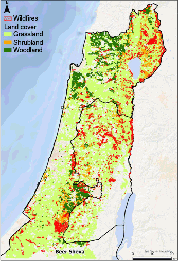
Israel has a large Mediterranean region which is characterized by significant fire activity during the dry season (on average, 285 fires larger than 10 ha per year between 2015 and 2022) (Guk et al. 2023). Climate change is expected to increase the frequency, intensity and extent of wildfires as a result of projected prolonged droughts, increased water evaporation and a higher frequency of intense heat waves (Israel Ministry of Environmental Protection 2023, retrieved from https://www.gov.il/BlobFolder/reports/1st-step-mapping/he/climate_change_and_energy_efficiency_1st-step-mapping.pdf). While climate is a major driver of fire activity, human-caused ignitions, such as arson or careless behavior, also significantly contribute to wildfire occurrences in Israel (Levin et al. 2016). Natural ignitions are rare in Israel; only six cases of lightning-induced fires have ever been documented (Paz et al. 2016).
The wildfire season in Israel coincides with the dry season, which takes place between mid-April and November (Levin and Saaroni 1999). However, the most deadly fire in Israel occurred on 2 December 2010 on Mount Carmel (Shavit et al. 2013). Most fires occur in the summer, but the largest fires (in terms of area) tend to occur in transition seasons (Levin and Heimowitz 2012). During this period, the synoptic systems that cause major forest fires are the North African (‘Sharav’) cyclone and the Red Sea trough system, as they both carry hot and dry air (Levin and Saaroni 1999). There is an especially high probability of large fires in the fall when fuel moisture is especially low after nearly 6 months without precipitation (Bar-Massada and Lebrija-Trejos 2021).
Wildfires in Israel are typically small, with the majority burning less than 10 ha, and are of short duration, often lasting less than a day. This is due to the relatively small and fragmented patches of forest, woodland and shrubland in the Mediterranean part of the country, which cover about 4300 km2 (Ben-Moshe and Renan 2022). Temporally, larger burned areas in Israel are associated with rainy years, as precipitation enhances herbaceous vegetation growth, while herbaceous species are the first to dry out at the end of the rainy season (Turco et al. 2017), thereby increasing the coverage of flash fuels. Also, planted pine forests (where recreational activity is common) and military training zones tend to be associated with more frequent fire events (Levin and Heimowitz 2012).
Data sets
Parameters and components of the fire danger rating as used by the Israel Meteorological Service
The IMS provides the Israel Fire and Rescue Authority as well as other emergency forces with a daily forecast for fire danger in Israel from the NFDRS’ output. The forecast is derived from two indices: the BI and the IC (https://ims.gov.il/en/FireIndexExplanation). From 2010 until recently, these NFDRS-based indices were computed at a national scale in Israel, with a spatial resolution of 1 km and 24 hourly values per day. For the calculation of fire danger indices, the whole study area is characterized by the IMS as herbaceous vegetation (despite the presence of many woodland ecosystems), containing various slope classes, and divided into two climate classes: class 1 (arid) and class 2 (semi-humid). Although later versions of the NFDRS (e.g. 1988 and 2016) introduced modifications and refinements, at the time we conducted our study, the IMS used the 1978 version operationally. Therefore, this study is based on the outputs of the NFDRS-1978, as implemented by the IMS.
Wildfire dataset
The national wildfire database of Israel was generated in a previous study (Guk et al. 2023), and includes 2276 wildfires larger than 10 ha (where 1 ha = 100 m × 100 m) with a total burned area of 142,911 ha between 2015 and 2022. We expanded this dataset and mapped the wildfires for 2023 using the same approach. In 2023, we included 128 wildfires with exact dates and 61 wildfires with recorded durations out of a total of 243 wildfires. To test the IMS fire risk indices, we used 1788 wildfires for which we had an exact occurrence date (Guk et al. 2023). For these wildfires, additional information on fire characteristics and landcover type was extracted from remote sensing and ancillary databases (Table 2). Given the unique context of some of the wildfires in Israel (Besenyő 2019; Levin et al. 2021), some of which result from military training or intentional arson, we tagged these specific cases within the dataset for later exclusion from some of the analyses to avoid introducing bias from non-representative human-caused fires. While the exact causes of all wildfires are not available, fires attributed to intentional arson (e.g. kites) or rockets (Takshe et al. 2012; Zych 2019) were identified by mapping wildfire occurrences near borders during periods of conflict.
| Attribute | Number of wildfires | |
|---|---|---|
| Burn scar area | 1788 | |
| Wildfire date | 1788 | |
| Wildfire duration (min) | 1043 | |
| Land cover (%herbaceous cover and %woodland cover) | 1788 | |
| Live fuel moisture content (LFMC) (two LFMC variables: the mean LFMC value 8 days prior to the wildfire, and the delta LFMC (ΔLFMC) value between 16 and 8 days before the wildfire.) | 1731 | |
| Burning Index | 1697 | |
| Military training zones | Inside/outside (608/1180) | |
| Intentional arson | 130 | |
| Distance to border | 1788 | |
| Distance to the nearest locality | 1788 | |
| % Continuous vegetation (woodland shrubland and herbaceous) within 3 km | 1788 |
Live fuel moisture content
An additional variable that could enhance the prediction of wildfire characteristics is LFMC. A study by Guk et al. (2024) compared three LFMC models (Yebra et al. 2018; Quan et al. 2021; Cunill Camprubí et al. 2022) and determined that the Australian model was the most suitable for Israel’s Mediterranean region. This model utilized a national land cover dataset comprising three vegetation classes (woodland, grassland and shrubland) to enhance the accuracy of LFMC mapping. Hence, we utilized LFMC data at 500 m resolution derived from this Australian MODerate Resolution Imaging Spectrometer (MODIS)-derived physical model for our analysis. For each fire polygon, we derived two LFMC variables: first, the mean LFMC value 8 days prior to the wildfire, and second, the delta LFMC value, which represents the change in LFMC from 16 to 8 days before the wildfire. These time frames were chosen to capture the dynamic nature of LFMC changes, reflecting the rapid drying of vegetation and its transition into a more flammable state. We selected these specific periods because the MODIS reflectance data are based on a 16-day composite, which aligns with the temporal resolution of the model (Guk et al. 2024).
Analysis
Examining the correspondence between fire danger indices and wildfire characteristics at different temporal scales
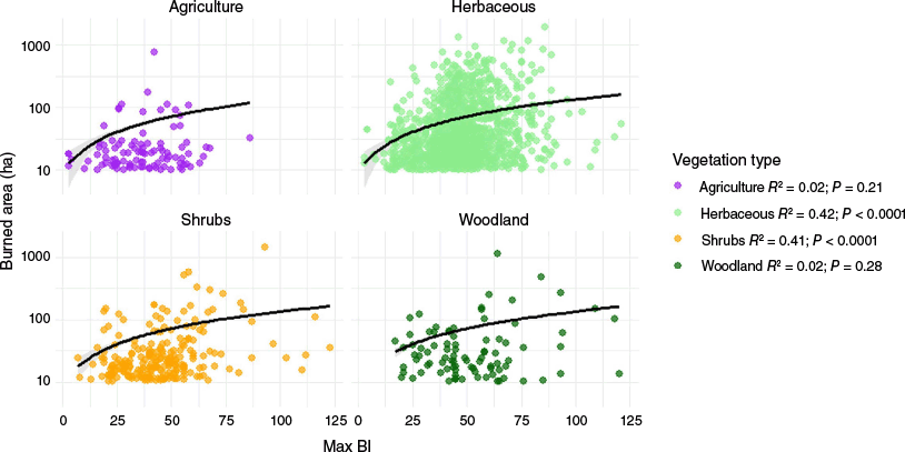
There was a strong correlation between BI and IC at a national spatial scale for all days in 2015–2023 (n = 2181; Spearman’s ρ = 0.92, P < 0.001). This correlation was computed solely to assess redundancy between the indices, and not to model their temporal relationship. We therefore included only BI in all subsequent analyses. We calculated the mean value of the daily BI index across all Mediterranean areas in Israel and the West Bank (Palestinian authority) at five temporal scales: event-based, daily, weekly, monthly and yearly (April–November, 2015–2023) and at two spatial scales: the entire study region (Fig. 1) and within the boundaries of individual wildfire events. For each wildfire, we calculated the mean BI value on the same day of the event by averaging the BI values of all grid cells (1 km resolution) intersecting with the burn scar polygon. Each fire danger index used here represents the daily maximum over the last 24 h. Then, we calculated Spearman’s correlation coefficient between wildfire characteristics (burned area and wildfire duration) and the fire danger index across different temporal scales (daily, weekly, monthly and yearly). To account for possible effects of fire size on these correlations (which are related to lower accuracy of ignition-date estimates for smaller fires), we set two threshold filters on wildfire size: 300 and 500 ha. Wildfires without a precise occurrence date were included in our analysis only at weekly, monthly and yearly scales. We further analyzed the Spearman’s rank correlation coefficient between BI and wildfire characteristics for four vegetation groups: Woodland, Shrubland, Herbaceous and Agriculture. Finally, we used quantile regression, implemented in XLStat (www.xlstat.com), to explore relationships across different wildfire size groups, focusing on quantiles less than or equal to 0.75. Higher quantiles (e.g. 0.9, 0.95 and 0.99) were excluded as the residuals were not randomly distributed around zero, potentially compromising the validity of the regression results.
Predictive models of wildfire characteristics
To explore the retrospective relationship between mean BI and wildfire characteristics at the individual fire level, we built Generalized Linear Models (GLMs) with an exponential response distribution to predict two wildfire characteristics: burned area and wildfire duration. Predictor variables included fire risk index (BI), vegetation type (expressed as the percentage of woody and herbaceous cover within the burned area) and vegetation continuity (within a 3 km buffer around the wildfire centroid), to represent the potential of the area that can be burned (Guk et al. 2024). Additional predictors included two LFMC variables (Guk et al. 2024), a binary variable indicating whether the fire occurred inside or outside a military training zone, distance to the nearest city and the distance to the country’s border (Table 2). All continuous predictor variables were standardized to a zero mean and unit variance prior to model fit to facilitate comparability of effect sizes. The binary variable was retained in its original form (0 or 1) to preserve interpretability. Additionally, to account for potential threshold responses of fire characteristics, we re-ran the models using filtered subsets of the data, focusing on specific wildfire size thresholds and geographic locations.
Results
Time series and variability of the fire risk index
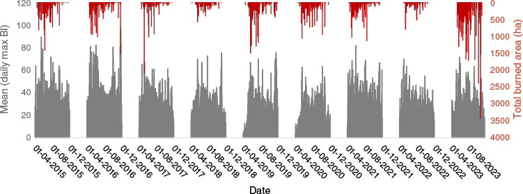
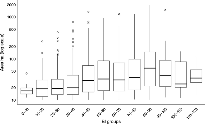
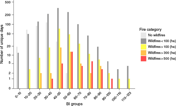
The time series of the BI and total burned area from wildfires at the national level, represented at a daily scale, are presented in Fig. 2. Despite some fluctuations in the BI index, larger burned areas were not consistently observed on days with higher BI values and the correlation between BI and burned area was low (Spearman’s ρ = 0.18). However, both the median and minimum sizes of burned areas were generally greater in the higher BI groups (Fig. 3). When analyzing the distribution of distinct calendar days across different BI bins, categorized by wildfire size, days without wildfires predominantly occurred at lower BI values (below 60) mainly in April, October and November, while larger wildfires were increasingly observed on days with higher BI (Fig. 4). The histogram in Fig. 4 underscores the tendency for larger wildfires to occur during periods with elevated fire risk, though smaller wildfires also occur at higher BI values.
Mean of daily national maximum Burned Index (BI) value and total burned area size (ha) by day at the national scale, for nine fire seasons between the years 2015 and 2023.
Box plot of burned area scars between 2015 and 2023 (n = 1697) in logarithmic scale, categorized by groups of National Fire-Danger Rating System’s Burned Index (BI). Each wildfire was assigned to the mean maximum index value by date and spatial intersect.
Histogram showing the frequency of unique days grouped by Burning Index (BI) bins for various wildfire size categories. Unique days refer to distinct days on which wildfires of different sizes occurred. The categories include days with no wildfires, wildfires smaller than 100 ha, wildfires between 100 and 300 ha, between 300 and 500 ha, and wildfires larger than 500 ha. Days with no wildfires include only those days not covered even by the date ranges of wildfires with unknown exact occurrence dates in our complete database. For the no-wildfires category, the BI represents the average BI across the entire study region.
Correlations between wildfire characteristics and BI across spatial, temporal scales and vegetation groups
In general, Spearman correlation coefficients (Fig. 5) between BI and wildfire characteristics (maximum, total and average burned area, as well as wildfire mean duration) were low to moderate and varied across temporal resolutions. The highest statistically significant correlation was observed at the monthly scale, when all wildfires were included, between maximum burned area and BI (Spearman’s ρ = 0.41). Notably, this correlation did not increase for larger fires. Only the weekly correlation for wildfires greater than 500 ha was higher than for other wildfire size groups at the same temporal scale. Furthermore, the correlation between wildfire duration and BI remained generally low across all temporal scales and wildfire sizes. An exception was wildfires larger than 300 ha, which had a Spearman correlation of 0.3 between BI and wildfire duration on a monthly scale. Across all wildfire size groups, daily correlations between BI and wildfire characteristics were consistently the weakest. These results suggest that BI was a better predictor of wildfire behavior over longer time frames.
Spearman correlation coefficient matrix between mean national Burning Index and wildfire characteristics: maximum burned area (of a single wildfire within that week/month/day/year), average burned area, total burned area and average wildfire duration. Correlations are analyzed at four temporal scales: yearly, monthly, weekly and daily, as well as across three wildfire groups (all wildfires [>10 ha], those larger than 300 ha, and those larger than 500 ha). Asterisks represent statistically significant correlations (*P < 0.05; **P < 0.01; ***P < 0.0001).
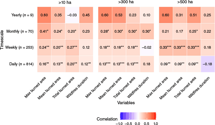
We further examined the correlation between BI and wildfire characteristics across vegetation types at the wildfire event scale. A weak but positive correlation was found between mean BI and wildfire characteristics (burned area and wildfire duration), based on Spearman’s rank correlation coefficient (ρ), calculated separately for each vegetation type. For burned area, ρ values ranged from 0.01 (Woodland) to 0.09 (Agriculture) to 0.2 (Herbaceous) and 0.27 (Shrubland), with statistically significant correlations observed in Herbaceous (P < 0.05) and Shrubland (P < 0.05). In contrast, the relationships were not statistically significant for Woodland (P = 0.87) or Agriculture (P = 0.35). For wildfire duration, correlations were uniformly low and ranged from 0 (Woodland) to 0.09 (Shrubland), and none were statistically significant. When quantile regression was applied without separating vegetation types, the highest R2 value for the relationship between BI and burned area (as the response variable) was 0.27 (statistically significant at the 0.75 quantile). In contrast, the variation in wildfire duration (as the response variable) was not well-explained by BI (R2 values below 0.01). When the data were separated into four vegetation groups, the highest R2 values (based on the quantile regression) for burned area were observed in Shrubland (R2 = 0.41) and Herbaceous (R2 = 0.42) at the 0.75 quantile, both statistically significant (Fig. 6). In comparison, R2 values for Woodland and Agriculture remained very weak across all quantiles. Additional R2 values for lower quantiles (0.1, 0.25 and 0.5) are presented in Appendix 4. For wildfire duration, all vegetation groups and quantiles had very low explained variances.
Models of wildfire characteristics
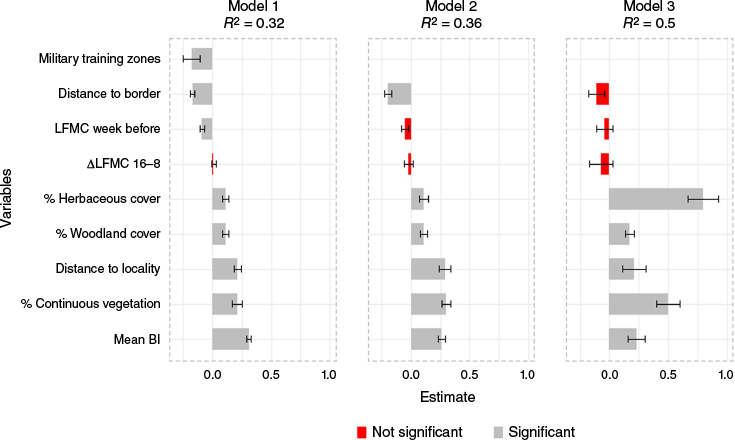
The variation in burned area was weakly explained (R2 = 0.32) by a GLM that included the following explanatory variables: Military training zones (binary), ΔLFMC 16-8, LFMC week before a wildfire, distance to border, distance to nearest locality, % Woodland cover, % Herbaceous cover, mean BI and % continuous vegetation within 3 km (Fig. 7). BI and the percentage of continuous vegetation within 3 km emerged as the strongest predictors of area burned, and both had significant positive effects (Fig. 7). Increasing the threshold for burned area to include only larger wildfires did not enhance the model’s performance. However, further analysis showed that when wildfires inside military training zones and wildfires caused by arson were excluded, the amount of explained variation in the burned area model improved slightly to 36% (Fig. 7). Furthermore, the highest explained variance in burned area (R2 = 0.5) was achieved when a threshold was set to include only wildfires with woodland cover higher than 0. This exclusion removed pure grassland wildfires (typically rangelands and agricultural fields) from the analysis (Fig. 7). In contrast, the GLM for wildfire duration, using the same explanatory variables, had virtually no explanatory power (R2 ~ 0).
Effect sizes of different variables in three generalized linear models predicting burned area at the level of individual wildfires (2015–2023), using an exponential response. Model 1: all wildfires (n = 1644). Model 2: wildfires outside military training zones and not classified as intentional arson (n = 987). Model 3: wildfires outside military training zones, not classified as intentional arson and with woodland cover greater than 0 (n = 214). All explanatory variables were standardized (z-scores) prior to model fit.
Discussion
Our study highlights the potential and limitations of the NFDRS-1978 in predicting wildfire characteristics in non-US Mediterranean regions, using Israel’s Mediterranean ecosystems as a case study aimed to enhance wildfire risk assessments. At the same time, we suggest a suite of local predictor variables that can improve the predictions of burned area models based on the NFDRS’ BI index, by accounting for the characteristics of the local fire regime.
Effectiveness of NFDRS in Israel’s Mediterranean ecosystems
A retrospective analysis of the BI using the wildfire database revealed moderate correlations with burned area, particularly at coarser temporal scales such as monthly and yearly, while correlations with wildfire duration remained relatively weak across all timescales. These findings support our first hypothesis that BI is not effective for predicting wildfire characteristics at finer temporal resolutions (daily and event-based) and for smaller wildfires. This result also aligns with previous findings from the US, where the NFDRS performed best on seasonal timescales but showed limited correlation with fire occurrence and size at finer temporal scales (Roads et al. 2005; Walding et al. 2018). However, we caution that these statistical analyses do not account for firefighting efforts, which directly influence the size and duration of the wildfire (Plucinski 2019). The unaccounted effect of suppression is a fundamental limitation in any attempt to find a relationship between wildfire characteristics and risk indices, as the absence of a variable for firefighting efforts in the models leaves a crucial explanatory factor unaddressed. It is possible that heightened alertness and rapid response by fire brigades prevented fires from spreading, thereby limiting their growth. However, data on firefighting efforts were not available to us.
In Israel, the strongest observed correlation between BI and a fire characteristic was between the monthly BI and maximum burned area (ρ = 0.41 for burned area >10 ha). However, this correlation did not improve significantly for larger wildfires, contrary to our second hypothesis. Although the correlation between BI and fire characteristics improved at longer temporal scales, relying on BI for long-term assessments remains problematic from a practical standpoint. If the index lacks a meaningful relationship with wildfire occurrence on a daily scale, its relevance for real world applications at monthly or yearly scales is also questionable. The limited explanatory power of the BI at finer scales may be attributed to the unique characteristics of Israel’s wildfire regime, where small, short-duration fires dominate (Levin et al. 2016). Additionally, human activities, including military training and intentional arson, play a significant role in ignition patterns, with 738 out of 1788 wildfires in our database attributed to these causes: 130 classified as intentional arson and 608 occurring within military training areas.
Furthermore, the classification of Israel’s diverse vegetation types as herbaceous by the IMS likely contributed to reduced model precision. When we explored the correlation between BI and burned area and duration of wildfires across different vegetation classes, no group demonstrated significantly better performance. However, quantile regression revealed that the predictive power of BI varies by quantile and vegetation type. For burned area, the highest correlations were observed at the 0.75 quantile in Shrubland (R2 = 0.41) and Herbaceous vegetation (R2 = 0.42), indicating moderate predictive power for larger fires in these classes. In contrast, Woodland and Agriculture consistently showed weak correlations across all quantiles. For wildfire duration, quantile regression confirmed universally weak correlations across all vegetation groups and quantiles, reinforcing the conclusion that BI is not a reliable predictor of wildfire duration, regardless of fire size or vegetation type.
Improving predictive models with ancillary data
Our results showed that incorporating vegetation and anthropogenic variables alongside BI enhanced the retrospective predictive ability of burned area models. Vegetation continuity within a 3 km radius and BI emerged as the strongest predictors of burned area, supporting our third hypothesis. However, the overall explained variance of these models (32%) remained relatively low. Excluding wildfires in military training areas and intentional arson fires (Besenyő 2019; Salvoldi et al. 2020; Perry and Amram 2024) slightly improved model performance (R2 = 0.36), underscoring the importance of filtering data to account for context-specific factors. The highest explained variance (50%) was achieved when examining only wildfires that occurred outside pure grasslands. This suggests that using context-specific adjustments to fire risk models, which in Israel include the incorporation of proximity to military zones or historical patterns of human-ignited fires, is essential for ensuring satisfactory model performance. The importance of local characteristics like the ones we found here, underscores the need to account for regionally-important characteristics of fire regimes when trying to adapt a fire risk system which was developed for another region with considerably different driving forces of wildfire activity.
In contrast to the moderate performance of the burned area models, the predictive ability of models of fire duration was consistently weaker, with near-zero explained variance. Possibly, this weak performance was due to the higher complexity of this wildfire characteristic compared to the burned area. Fire duration depends on various interacting factors, including suppression efforts (which in turn depend on accessibility to the fire perimeter and on the amount and capabilities of firefighting forces), fuel type and weather conditions (which together affect fire behavior, affecting the ease of suppression), and is often less accurately recorded due to manual field reporting. Generally, modifications to incorporate locally calibrated thresholds and region-specific parameters, such as precipitation trends and vegetation phenology, may improve daily forecasts of fire risk.
While this study focused on the BI due to its operational use by the IMS, future research could benefit from exploring the individual components of the NFDRS, such as the SC or ERC. These components may offer more direct insight into the physical drivers of fire size. However, such an analysis was not feasible in our case, as only BI and IC are currently calculated by the IMS.
Beyond these data-related limitations, it is also important to acknowledge the conceptual constraints of the NFDRS itself. While our analysis examined relationships between the BI and characteristics of fires that had already occurred (e.g. burned area and duration), the NFDRS was not originally designed to predict specific fire outcomes. Rather, like its Canadian and Australian counterparts, the NFDRS was developed to estimate potential fire behavior assuming ignition (Deeming 1972; Noble et al. 1980; Stocks et al. 1989). Applying the NFDRS beyond this purpose may therefore lead to misinterpretation. Instead, we suggest a practical adaptation: local calibration of danger class thresholds to better reflect observed fire behavior in specific regions. Although we did not conduct such calibration in this study, our findings indicate its potential to improve the relevance of NFDRS outputs in Israel’s Mediterranean context. Indeed, as our findings show, the BI correlates moderately with burned area at coarse scales, especially for certain vegetation types and quantiles, suggesting that calibrated thresholds may allow managers to interpret fire danger outputs in ways that better align with local realities.
Conclusion
Our study demonstrates the potential of the NFDRS-1978 to inform one aspect of wildfire risk in non-US Mediterranean-type ecosystems, by revealing that BI has a moderate predictive capability of burned area as long as it is complemented by local variables. On the flip side, our results highlight the limitations of NFDRS-1978 in predicting fire characteristics when its indices are utilized without regional adaptation, i.e. a naïve application of NFDRS-1978 to predict fire risk outside the US is unadvisable. Hence, our findings underscore the importance of customizing fire danger rating systems to local contexts. While the NFDRS provides a robust framework and the variance within the US is large enough so that Israel’s climate may fall within this range, its direct application in Israel’s Mediterranean ecosystems (and probably to any other region outside the US) requires significant modifications to account for the local environment and vegetation, and to any other variable that is particular to the local fire regime. Therefore, fire managers should first identify and then integrate such variables (e.g. LFMC, vegetation continuity and site-specific anthropogenic factors) in fire risk models to enhance the accuracy of predictions of wildfire characteristics by NFDRS’ indices. By incorporating ancillary data and refining model parameters, fire managers can improve the reliability of wildfire predictions, ultimately supporting better-preparedness strategies and mitigation efforts in Israel and similar Mediterranean regions.
Data availability
The data that support this study will be shared upon reasonable request to the corresponding author.
Acknowledgements
This work was supported by ‘Atid Ba Ivrit’ and David Amiran Scholarships of the Hebrew University of Jerusalem, Israel. We thank the IMS for providing the IC and BI data. We also thank the anonymous reviewers for their helpful suggestions.
References
Bar-Massada A, Lebrija-Trejos E (2021) Spatial and temporal dynamics of live fuel moisture content in eastern Mediterranean woodlands are driven by an interaction between climate and community structure. International Journal of Wildland Fire 30(3), 190-196.
| Crossref | Google Scholar |
Bar Massada A, Radeloff VC, Stewart SI, Hawbaker TJ (2009) Wildfire risk in the wildland–urban interface: a simulation study in northwestern Wisconsin. Forest Ecology and Management 258(9), 1990-1999.
| Crossref | Google Scholar |
Besenyő J (2019) Inferno terror: forest fires as the new form of terrorism. Terrorism and Political Violence 31(6), 1229-1241.
| Crossref | Google Scholar |
Buffington T, Ezekoye OA (2019) Statistical analysis of fire department response times and effects on fire outcomes in the United States. Fire Technology 55(6), 2369-2393.
| Crossref | Google Scholar |
Butsic V, Kelly M, Moritz M (2015) Land use and wildfire: a review of local interactions and teleconnections. Land 4(1), 140-156.
| Crossref | Google Scholar |
Carmel Y, Paz S, Jahashan F, Shoshany M (2009) Assessing fire risk using Monte Carlo simulations of fire spread. Forest Ecology and Management 257(1), 370-377.
| Crossref | Google Scholar |
Castel-Clavera J, Pimont F, Opitz T, Ruffault J, Barbero R, Allard D, Dupuy J-L (2025) A comparative analysis of fire-weather indices for enhanced fire activity prediction with probabilistic approaches. Agricultural and Forest Meteorology 361, 110315.
| Crossref | Google Scholar |
Chas-Amil ML, Prestemon JP, McClean CJ, Touza J (2015) Human-ignited wildfire patterns and responses to policy shifts. Applied Geography 56, 164-176.
| Crossref | Google Scholar |
Chuvieco E, Yebra M, Martino S, Thonicke K, Gómez-Giménez M, San-Miguel J, Oom D, Velea R, Mouillot F, Molina JR, Miranda AI, Lopes D, Salis M, Bugaric M, Sofiev M, Kadantsev E, Gitas IZ, Stavrakoudis D, Eftychidis G, Bar-Massada A, Neidermeier A, Pampanoni V, Pettinari ML, Arrogante-Funes F, Ochoa C, Moreira B, Viegas D (2023) Towards an integrated approach to wildfire risk assessment: when, where, what and how may the landscapes burn. Fire 6(5), 215.
| Crossref | Google Scholar |
Cunill Camprubí À, González-Moreno P, Resco De Dios V (2022) Live fuel moisture content mapping in the Mediterranean Basin using random forests and combining MODIS spectral and thermal data. Remote Sensing 14(13), 3162.
| Crossref | Google Scholar |
Dennison PE, Moritz MA (2009) Critical live fuel moisture in chaparral ecosystems: a threshold for fire activity and its relationship to antecedent precipitation. International Journal of Wildland Fire 18(8), 1021-1027.
| Crossref | Google Scholar |
Dillon GK, Holden ZA, Morgan P, Crimmins MA, Heyerdahl EK, Luce CH (2011) Both topography and climate affected forest and woodland burn severity in two regions of the western US, 1984 to 2006. Ecosphere 2(12), art130.
| Crossref | Google Scholar |
Dupuy J, Fargeon H, Martin-StPaul N, Pimont F, Ruffault J, Guijarro M, Hernando C, Madrigal J, Fernandes P (2020) Climate change impact on future wildfire danger and activity in southern Europe: a review. Annals of Forest Science 77(2), 35.
| Crossref | Google Scholar |
Freeborn PH, Cochrane MA, Jolly WM (2015) Relationships between fire danger and the daily number and daily growth of active incidents burning in the northern Rocky Mountains, USA. International Journal of Wildland Fire 24(7), 900-910.
| Crossref | Google Scholar |
Freeborn PH, Jolly WM, Cochrane MA (2016) Impacts of changing fire weather conditions on reconstructed trends in U.S. wildland fire activity from 1979 to 2014. Journal of Geophysical Research: Biogeosciences 121(11), 2856-2876.
| Crossref | Google Scholar |
Grillakis M, Voulgarakis A, Rovithakis A, Seiradakis KD, Koutroulis A, Field RD, Kasoar M, Papadopoulos A, Lazaridis M (2022) Climate drivers of global wildfire burned area. Environmental Research Letters 17(4), 045021.
| Crossref | Google Scholar |
Guk E, Bar-Massada A, Levin N (2023) Constructing a comprehensive national wildfire database from incomplete sources: Israel as a Case Study. Fire 6(4), 131.
| Crossref | Google Scholar |
Guk E, Bar-Massada A, Yebra M, Scortechini G, Levin N (2024) Examining the transferability of remote-sensing-based models of live fuel moisture content for predicting wildfire characteristics. IEEE Journal of Selected Topics in Applied Earth Observations and Remote Sensing 17, 14762-14776.
| Crossref | Google Scholar |
Hamadeh N, Karouni A, Daya B, Chauvet P (2017) Using correlative data analysis to develop weather index that estimates the risk of forest fires in Lebanon & Mediterranean: assessment versus prevalent meteorological indices. Case Studies in Fire Safety 7, 8-22.
| Crossref | Google Scholar |
Israel Ministry of Environmental Protection (2024) Climate Change and Energy Efficiency - 1st Step Mapping (in Hebrew). Retrieved from https://www.gov.il/BlobFolder/reports/1st-step-mapping/he/climate_change_and_energy_efficiency_1st-step-mapping.pdf
Ivanov EP (2025) Modeling fire company staffing to investigate its effect on effective response force times to structure fires using local incident data. Fire Technology 61(2), 857-873.
| Crossref | Google Scholar |
Jones MW, Abatzoglou JT, Veraverbeke S, Andela N, Lasslop G, Forkel M, Smith AJP, Burton C, Betts RA, Van Der Werf GR, Sitch S, Canadell JG, Santín C, Kolden C, Doerr SH, Le Quéré C (2022) Global and regional trends and drivers of fire under climate change. Reviews of Geophysics 60(3), e2020RG000726.
| Crossref | Google Scholar |
Kang Z, Quan X, Lai G (2023) Assessing the effects of fuel moisture content on the 2018 megafires in California. IEEE Journal of Selected Topics in Applied Earth Observations and Remote Sensing 16, 868-877.
| Crossref | Google Scholar |
Laneve G, Pampanoni V, Uddien Shaik R (2020) The daily fire hazard index: a fire danger rating method for Mediterranean areas. Remote Sensing 12(15), 2356.
| Crossref | Google Scholar |
Levin N, Heimowitz A (2012) Mapping spatial and temporal patterns of Mediterranean wildfires from MODIS. Remote Sensing of Environment 126, 12-26.
| Crossref | Google Scholar |
Levin N, Saaroni H (1999) Fire weather in Israel — synoptic climatological analysis. GeoJournal 47(4), 523-538.
| Crossref | Google Scholar |
Levin N, Tessler N, Smith A, McAlpine C (2016) The human and physical determinants of wildfires and burnt areas in Israel. Environmental Management 58(3), 549-562.
| Crossref | Google Scholar | PubMed |
Levin N, Yebra M, Phinn S (2021) Unveiling the factors responsible for Australia’s Black Summer Fires of 2019/2020. Fire 4(3), 58.
| Crossref | Google Scholar |
Liu Y, Stanturf J, Goodrick S (2010) Trends in global wildfire potential in a changing climate. Forest Ecology and Management 259(4), 685-697.
| Crossref | Google Scholar |
Liu Y, Goodrick S, Heilman W (2014) Wildland fire emissions, carbon, and climate: wildfire–climate interactions. Forest Ecology and Management 317, 80-96.
| Crossref | Google Scholar |
Miller C, Ager AA (2013) A review of recent advances in risk analysis for wildfire management. International Journal of Wildland Fire 22(1), 1-14.
| Crossref | Google Scholar |
Mitsopoulos I, Mallinis G, Arianoutsou M (2015) Wildfire risk assessment in a typical Mediterranean wildland–urban interface of Greece. Environmental Management 55(4), 900-915.
| Crossref | Google Scholar | PubMed |
Moritz MA, Morais ME, Summerell LA, Carlson JM, Doyle J (2005) Wildfires, complexity, and highly optimized tolerance. Proceedings of the National Academy of Sciences 102(50), 17912-17917.
| Crossref | Google Scholar | PubMed |
Moritz MA, Batllori E, Bradstock RA, Gill AM, Handmer J, Hessburg PF, Leonard J, McCaffrey S, Odion DC, Schoennagel T, Syphard AD (2014) Learning to coexist with wildfire. Nature 515(7525), 58-66.
| Crossref | Google Scholar | PubMed |
Noble IR, Gill AM, Bary GAV (1980) McArthur’s fire‐danger meters expressed as equations. Australian Journal of Ecology 5(2), 201-203.
| Crossref | Google Scholar |
Paz S, Inbar M, Kutiel H, Malkinson D, Tessler N, Wittenberg L (2016) Wildfires in the eastern Mediterranean as a result of lightning activity – a change in the conventional knowledge. International Journal of Wildland Fire 25(5), 592-596.
| Crossref | Google Scholar |
Perry S, Amram S (2024) “Hot Forests”: spatial concentration of forest “Pyro-Terrorism” in Israel. International Annals of Criminology 62(1), 30-55.
| Crossref | Google Scholar |
Plucinski MP (2019) Fighting flames and forging firelines: wildfire suppression effectiveness at the fire edge. Current Forestry Reports 5(1), 1-19.
| Crossref | Google Scholar |
Quan X, Yebra M, Riaño D, He B, Lai G, Liu X (2021) Global fuel moisture content mapping from MODIS. International Journal of Applied Earth Observation and Geoinformation 101, 102354.
| Crossref | Google Scholar |
Roads J, Fujioka F, Chen S, Burgan R (2005) Seasonal fire danger forecasts for the USA. International Journal of Wildland Fire 14(1), 1-18.
| Crossref | Google Scholar |
Salvoldi M, Siaki G, Sprintsin M, Karnieli A (2020) Burned area mapping using multi-temporal Sentinel-2 data by applying the Relative Differenced Aerosol-Free Vegetation Index (RdAFRI). Remote Sensing 12(17), 2753.
| Crossref | Google Scholar |
Schlobohm P, Brain J (2002) Gaining an understanding of the national fire danger rating system (PMS 932). National Wildfire Coordinating Group Report NFES 2665. (Boise, ID, USA). Available at https://gacc.nifc.gov/rmcc/predictive/nfdrs_gaining_understanding.pdf
Shadrin D, Illarionova S, Gubanov F, Evteeva K, Mironenko M, Levchunets I, Belousov R, Burnaev E (2024) Wildfire spreading prediction using multimodal data and deep neural network approach. Scientific Reports 14(1), 2606.
| Crossref | Google Scholar | PubMed |
Shavit T, Shahrabani S, Benzion U, Rosenboim M (2013) The effect of a forest fire disaster on emotions and perceptions of risk: a field study after the Carmel fire. Journal of Environmental Psychology 36, 129-135.
| Crossref | Google Scholar |
Shmuel A, Ziv Y, Heifetz E (2022) Machine-Learning-based evaluation of the time-lagged effect of meteorological factors on 10-hour dead fuel moisture content. Forest Ecology and Management 505, 119897.
| Crossref | Google Scholar |
Stocks BJ, Lynham TJ, Lawson BD, Alexander ME, Wagner CEV, McAlpine RS, Dubé DE (1989) The Canadian forest fire danger rating system: an overview. The Forestry Chronicle 65(6), 450-457.
| Crossref | Google Scholar |
Szpakowski D, Jensen J (2019) A review of the applications of remote sensing in fire ecology. Remote Sensing 11(22), 2638.
| Crossref | Google Scholar |
Takshe AA, Van Der Molen I, Lovett JC (2012) Examining the lack of legal remedies for environmental damage in the 2006 Lebanon–Israel war. Environmental Policy and Governance 22(1), 27-41.
| Crossref | Google Scholar |
Tian X, Mcrae DJ, Boychuk D, Jin J, Gao C, Shu L, Wang M (2005) Comparisons and assessment of forest fire danger systems. Forestry Studies in China 7(1), 53-61.
| Crossref | Google Scholar |
Turco M, von Hardenberg J, AghaKouchak A, Llasat MC, Provenzale A, Trigo RM (2017) On the key role of droughts in the dynamics of summer fires in Mediterranean Europe. Scientific Reports 7(1), 81.
| Crossref | Google Scholar | PubMed |
Van Wilgen BW (1984) Adaptation of the United States Fire Danger Rating System to fynbos conditions: Part I. A fuel model for fire danger rating in the fynbos biome. South African Forestry Journal 129(1), 61-65.
| Crossref | Google Scholar |
Van Wilgen BW, Burgan RE (1984) Adaptation of the United States Fire Danger Rating System to fynbos conditions: Part II. Historic fire danger in the fynbos biome. South African Forestry Journal 129(1), 66-78.
| Crossref | Google Scholar |
Walding NG, Williams HTP, McGarvie S, Belcher CM (2018) A comparison of the US National Fire Danger Rating System (NFDRS) with recorded fire occurrence and final fire size. International Journal of Wildland Fire 27(2), 99-113.
| Crossref | Google Scholar |
Weinstein DA, Woodbury PB (2010) Review of Methods for Developing Probabilistic Risk Assessments. Part 1: Modeling Fire. In Pye, John M.; Rauscher, H. Michael; Sands, Yasmeen; Lee, Danny C.; Beatty, Jerome S., tech. eds. Advances in threat assessment and their application to forest and rangeland management. Gen. Tech. Rep. PNW-GTR-802. Portland, OR: U.S. Department of Agriculture, Forest Service, Pacific Northwest and Southern Research Stations: 285–302.
Weise DR, Stephens SL, Fujioka FM, Moody TJ, Benoit J (2010) Estimation of fire danger in Hawai’i using limited weather data and simulation. Pacific Science 64(2), 199-220.
| Crossref | Google Scholar |
Xofis P, Konstantinidis P, Papadopoulos I, Tsiourlis G (2020) Integrating remote sensing methods and fire simulation models to estimate fire hazard in a South-East Mediterranean protected area. Fire 3(3), 31.
| Crossref | Google Scholar |
Yebra M, Dennison PE, Chuvieco E, Riaño D, Zylstra P, Hunt ER, Danson FM, Qi Y, Jurdao S (2013) A global review of remote sensing of live fuel moisture content for fire danger assessment: moving towards operational products. Remote Sensing of Environment 136, 455-468.
| Crossref | Google Scholar |
Yebra M, Quan X, Riaño D, Rozas Larraondo P, Van Dijk AIJM, Cary GJ (2018) A fuel moisture content and flammability monitoring methodology for continental Australia based on optical remote sensing. Remote Sensing of Environment 212, 260-272.
| Crossref | Google Scholar |
Zych J (2019) The use of weaponized kites and balloons in the Israeli – Palestinian conflict. Security and Defence Quarterly 27(5), 71-83.
| Crossref | Google Scholar |
Appendix 1.Description of the parameters that need to be defined by the user for the representation of site-local conditions for the NFDRS (Schlobohm and Brain 2002)
| Site descriptor | Classes of input variables | |
|---|---|---|
| Climate | Class 1 – arid or semi-arid desert | |
| Class 2 – semi-humid climate (moisture in summer is deficient) | ||
| Class 3 – semi-humid climate (summertime precipitation is adequate to sustain plant growth) | ||
| Class 4 – wet coastal area (summertime precipitation and fog are common) | ||
| Slope | Group 1: 0–25% | |
| Group 2: 26–40% | ||
| Group 3: 41–55% | ||
| Group 4: 56–75% | ||
| Group 5: >75% | ||
| Fuel models | Six general groups of dead and live plant material: | |
| Lichens and mosses; | ||
| Marsh grasses and reeds; | ||
| Grasses and forbs; | ||
| Brush, shrubs and tree reproduction; | ||
| Trees; | ||
| Slash. | ||
| Grass type (live fuel type) | Annual grasses (not affected significantly by seasonal weather factors such as temperature or precipitation) | |
| Perennial grasses (affected by temperature and precipitation) |
Appendix 2.Codes of state of weather in the NFDRS-1978 (Schlobohm and Brain 2002)
0. Clear (less than 1/10 of the sky cloud covered)
1. Scattered clouds (1/10–5/10 of sky cloud covered)
2. Broken clouds (6/10–9/10 of sky cloud covered)
3. Overcast (more than 9/10 of sky cloud covered)
4. Foggy
5. Drizzling (precipitation of numerous fine droplets, misting)
6. Raining
7. Snowing or sleeting
8. Showering (in sight of or occurring at station)
9 Thunderstorms in progress (lightning seen or thunder heard within 30 miles of observation site)
Appendix 3.Description of the input observations and NFDRS-1978 parameters (Schlobohm and Brain 2002)
| Input parameters and variables of NFDRS-1978 | Description | |
|---|---|---|
| State of Herbaceous Vegetation | The user needs to set the starting date of the growing season and if there is an occurrence of a killing frost. By assigning the climate class, the model can estimate when the growing season ends but the user needs to determine when to start the growing season from field observations. | |
| Staffing Index and Display Class Breakpoints | The NFDRS user must first determine which indices or components they want to use and then set the number of breakpoints or classes to be displayed/calculated depending on the agency policy decision. | |
| Measured Woody Fuel Moisture | The woody moisture can be computed from weather data only, or both weather data and the measured woody moisture. Fire managers have an option to calibrate the woody fuel moisture model by monthly physical measurements of the moisture content of the small branch wood and foliage of live woody plants. After entering all data required, the system supplies two types of output: intermediate output and the indices and components of the fire danger. The intermediate output is the calculated fuel moisture values for the various classes of live (herbaceous or woody) and dead fuels used to produce the final indices and components. | |
| There are four-time-lag classes that represent the modeled fuel moisture of dead fuels. Time-lag is the time necessary for a fuel particle of a particular size to lose approximately two-thirds of the difference between its initial moisture content and its equilibrium moisture content in its current environment. |
Appendix 4.R2 values from quantile regressions predicting burned area across vegetation types and quantiles
| Vegetation type | Quantile 0.1 | Quantile 0.25 | Quantile 0.5 | Quantile 0.75 | ||
|---|---|---|---|---|---|---|
| Shrubland | R2 | 0.011 | 0.049 | 0.132 | 0.415 | |
| Herbaceous | R2 | 0.035 | 0.070 | 0.198 | 0.429 | |
| Woodland | R2 | 0.050 | 0.060 | 0.040 | 0.028 | |
| Agriculture | R2 | 0.023 | 0.023 | 0.019 | 0.020 |
Statistically significant values (P < 0.05) are shown in black, while non-significant values are shaded in gray.