

Drone thermal imaging technology provides a cost-effective tool for landscape-scale monitoring of a cryptic forest-dwelling species across all population densities
Lachlan G. Howell A B C G , John Clulow A C , Neil R. Jordan D E , Chad T. Beranek A C , Shelby A. Ryan A C , Adam Roff A F and Ryan R. Witt A C
A School of Environmental and Life Sciences, Biology Building, University of Newcastle, University Drive, Callaghan, NSW 2308, Australia.
B Centre for Integrative Ecology, School of Life and Environmental Sciences, Deakin University Geelong, Melbourne Burwood Campus, 221 Burwood Highway, Burwood, Vic. 3125, Australia
C FAUNA Research Alliance, PO Box 5092, Kahibah, NSW 2290, Australia.
D Centre for Ecosystem Science, School of BEES, University of New South Wales (UNSW Sydney), Sydney, NSW 2052, Australia.
E Taronga Institute of Science and Learning, Taronga Conservation Society Australia, Taronga Western Plains Zoo, Dubbo, NSW 2830, Australia.
F Science Division, Department of Planning, Industry and Environment, Newcastle, NSW 2300, Australia.
G Corresponding author. Email: lachlan.howell@newcastle.edu.au
Wildlife Research 49(1) 66-78 https://doi.org/10.1071/WR21034
Submitted: 11 February 2021 Accepted: 17 September 2021 Published: 20 December 2021
Journal Compilation © CSIRO 2022 Open Access CC BY-NC
Abstract
Context: Drones, or remotely piloted aircraft systems, equipped with thermal imaging technology (RPAS thermal imaging) have recently emerged as a powerful monitoring tool for koala populations. Before wide uptake of novel technologies by government, conservation practitioners and researchers, evidence of greater efficiency and cost-effectiveness than with other available methods is required.
Aims: We aimed to provide the first comprehensive analysis of the cost-effectiveness of RPAS thermal imaging for koala detection against two field-based methods, systematic spotlighting (Spotlight) and the refined diurnal radial search component of the spot-assessment technique (SAT).
Methods: We conducted various economic comparisons, particularly comparative cost-effectiveness of RPAS thermal imaging, Spotlight and SAT for repeat surveys of a low-density koala population. We compared methods on cost-effectiveness as well as long-term costs by using accumulating cost models. We also compared detection costs across population density using a predictive cost model.
Key results: Despite substantial hardware, training and licensing costs at the outset (>A$49 900), RPAS thermal imaging surveys were cost-effective, detecting the highest number of koalas per dollar spent. Modelling also suggested that RPAS thermal imaging requires the lowest survey effort to detect koalas within the range of publicly available koala population densities (~0.006–18 koalas ha−1) and would provide long-term cost reductions across longitudinal monitoring programs. RPAS thermal imaging would also require the lowest average survey effort costs at a landscape scale (A$3.84 ha−1), providing a cost-effective tool across large spatial areas.
Conclusions: Our analyses demonstrated drone thermal imaging technology as a cost-effective tool for conservation practitioners monitoring koala populations. Our analyses may also form the basis of decision-making tools to estimate survey effort or total program costs across any koala population density.
Implications: Our novel approach offers a means to perform various economic comparisons of available survey techniques and guide investment decisions towards developing standardised koala monitoring approaches. Our results may assist stakeholders and policymakers to confidently invest in RPAS thermal imaging technology and achieve optimal conservation outcomes for koala populations, with standardised data collection delivered through evidence-based and cost-effective monitoring programs.
Keywords: cost-effectiveness, density, drones, koala, population monitoring, Phascolarctos cinereus, survey methods.
Introduction
A recent parliamentary inquiry into the state of koala populations and habitat in New South Wales (NSW) showed a range of inadequacies in koala monitoring programs (NSW Legislative Council 2020). Existing population estimates and monitoring outcomes are now considered unreliable and outdated, and the quality and inconsistency of baseline monitoring data has not assisted land-use decision-making for koala habitat management. This has, arguably, contributed to localised declines, limited the understanding of the status of koala populations and imperilled the species, which now faces many local extinctions (McAlpine et al. 2015; Woinarski and Burbidge 2016; NSW Legislative Council 2020). A suggested solution for inadequacies in koala monitoring, and a key step in the recovery of koala populations after the 2019/2020 Black Summer Bushfires, is the development of a cost-effective standardised approach to monitoring koala populations nationally (Dickman et al. 2020; Nolan et al. 2020; NSW Legislative Council 2020).
Because of the koala’s cryptic nature, there are a range of traditional survey methods and emerging tools and technologies for the direct and indirect detection of koalas (Dique et al. 2003; Phillips and Callaghan 2011; Cristescu et al. 2015; Brown et al. 2018; Law et al. 2018; Corcoran et al. 2019; Wilmott et al. 2019; Witt et al. 2020; Beranek et al. 2021). Koalas are spread unevenly across a large subcontinental landscape, often at low population densities; therefore, koala monitoring can be laborious and expensive (McAlpine et al. 2015). As a result, practitioners often favour indirect, non-observational survey techniques as low-cost options for koala monitoring across broad landscapes (e.g. audio technology by Government departments or scat-based techniques by the private sector; NSW Legislative Council 2020), demonstrating the difficult balance that exists among survey effort, detection success, and available budget across extensive landscapes (Rhodes et al. 2006; Ellis et al. 2013).
Remotely piloted aircraft systems (RPAS; also known as ‘drones’) with thermal imaging technology (hereafter referred to as ‘RPAS thermal imaging’) have recently emerged as a powerful tool for detecting and monitoring wildlife and are experiencing uptake as a koala monitoring tool across multiple sectors (Hodgson et al. 2018; Burke et al. 2019; Corcoran et al. 2019; Leigh et al. 2019; Beranek et al. 2021; Hamilton et al. 2020; NSW Legislative Council 2020; Witt et al. 2020). There is promising, although preliminary, evidence of RPAS technology being used as a fire response tool to detect and rescue koalas, resulting in the potential future uptake and support, in principle, of the technology by a major government stakeholder (Department of Planning Industry and Environment 2020; NSW Legislative Council 2020).
The combination of RPAS thermal imaging technology and machine learning algorithms using thermal imagery data has been used to successfully detect and confirm koala presence (Corcoran et al. 2019; Hamilton et al. 2020). In these instances, koala thermal signatures were validated during ex situ automated and manual frame by frame examination of RPAS thermal imaging derived footage posthoc (Corcoran et al. 2019; Hamilton et al. 2020). The need for direct detection during koala monitoring to collect fine-scale population data (i.e. demographics, disease prevalence, recruitment) necessary to target on-ground management interventions has prompted the recent development of novel RPAS thermal imaging protocols that generate successful real-time koala detections in field, using RPAS thermal imaging-derived footage review by on-ground observer/s (Leigh et al. 2019; Witt et al. 2020; Beranek et al. 2021). This RPAS thermal imaging protocol provided reliable density estimates for the Port Stephens (NSW) koala population, as well as a higher detection probability and effective detectability than with systematic spotlighting (Spotlight) and the refined diurnal radial search component of the spot-assessment technique (SAT; sometimes referred to as a ‘koala point survey’; Witt et al. 2020). Although RPAS thermal imaging technology for koala detection is still in development, and current real-time monitoring protocols are limited to the cooler months in winter (Beranek et al. 2021; Witt et al. 2020), there is growing uptake of the technology for koala monitoring.
Given koalas live across large areas that cross many jurisdictions and land tenures, there is an extensive array and diversity of public and private stakeholder groups conducting koala monitoring (McAlpine et al. 2015; NSW Legislative Council 2020). Local councils, community and industry groups, government departments and researchers may all at times survey localised koala populations with varying resources and monitoring budgets. A concern among many stakeholders is that while technologies may develop to improve koala research and monitoring, a major barrier is likely to be high costs (NSW Legislative Council 2020). Before a novel technology for koala monitoring can be confidently taken up by relevant stakeholders, there must be evidence of increased cost-effectiveness against already established methods (Lahoz-Monfort and Tingley 2018).
RPAS thermal imaging technology is widely proposed as a cost-effective technique for wildlife monitoring; however, concern among practitioners has been raised over the validity of these claims (Hodgson et al. 2018), potentially owing to the lack of any formal assessment of the cost-effectiveness of RPAS thermal imaging technology for surveying wildlife. The koala has historically received disproportionately large public and community funding compared with that for other threatened species (Tisdell and Nantha 2006; Rhodes et al. 2017; Office of Environment and Heritage 2018), without yet securing the future of the species. Input of ongoing public and private resources is likely to continue following the 2019/2020 Black Summer Bushfires because of the iconic status of the species, tourism and economic value, as well as widespread domestic and international media attention (Hundloe and Hamilton 1997; Dickman et al. 2020; Markwell 2020; Nolan et al. 2020; NSW Legislative Council 2020). It thus behoves policy makers to ensure future investment into koala conservation, including monitoring efforts, delivers outcomes and incorporates the most cost-effective available monitoring tools, ultimately ensuring that resources are well spent.
We provide the first comprehensive analysis of the cost-effectiveness of RPAS thermal imaging technology as a tool for monitoring koala populations. We compare RPAS thermal imaging to two field-based methods available for koala monitoring, namely, systematic spotlighting (Spotlight) and the refined diurnal radial search component of the spot-assessment technique (SAT) originally compared in Witt et al. (2020). The selection of these three survey methods is restricted by the methods originally compared in Witt et al. (2020). The present study provides an approach to compare the range of available survey method options that are not analysed here, but which also require an analysis of cost-effectiveness (e.g. the line transect method, double-count method, audio detection technology and koala detection dogs). We compare the overall costs to conduct surveys of the Port Stephens (NSW) koala population reported in Witt et al. (2020), and use these estimates to compare methods for long-term longitudinal monitoring using an accumulating cost model, as well as across different landscape scales using the case study of large areas of habitat affected in the 2019/2020 Black Summer Bushfires. We compare cost-effectiveness of each method for the direct detection of koalas in the low-density Port Stephens population. We also generate a predictive cost model to compare survey methods across the range of koala population densities likely to require monitoring. The analyses in this investigation may provide the basis for a decision-making tool to guide survey method selection on the basis of cost-effectiveness and determine whether RPAS thermal imaging technology can provide practitioners with a much-needed landscape-scale cost-effective monitoring tool for koala populations.
Methods
Economic analyses and investigations
We provide a range of analyses and investigations, including the following:
(1) Comparative estimates of costs to survey koalas using systematic spotlighting (Spotlight), remotely piloted aircraft system (RPAS) thermal imaging (RPAS thermal imaging) and the refined diurnal radial search component of the spot-assessment technique (SAT). Costings data represent comprehensive estimates of overhead fixed and variable costs of labour, travel and equipment, required to conduct repeat surveys of sites of known koala presence in Port Stephens, NSW (an important localised low-density regional koala population in NSW unaffected by the 2019/2020 Black Summer Bushfires; Beranek et al. 2021; NSW Legislative Council 2020; Witt et al. 2020). We also generate an accumulating cost model to forecast potential costs of long-term (10-year) monitoring of the case study population on the basis of koala survey-method selection.
(2) Comparative estimates of average survey effort costs per hectare ( ) using Spotlight, RPAS thermal imaging and refined SAT surveys. These costings data can be used to compare costs for koala population monitoring at a landscape scale, across a broad range of cross-tenure koala habitat. Costings data can provide a useful decision-making tool to inform survey method selection by applying the known size of target koala habitat to be monitored and the equipment costs, so as to estimate required comparative stakeholder and/or practitioner budgets for koala monitoring. As an illustrative example, we provide estimates of comparative monitoring costs across different areas of koala habitat affected by the 2019/2020 Australian Black Summer Bushfires, including the fire-affected 1.9 million hectares of ‘high- or very high suitability’ koala habitat in eastern NSW and the fire-affected 7295.6 ha of ‘high priority koala habitat’ reported in the North Coast Port Macquarie-Hastings Council region, which hosts a significant localised regional koala population (NSW Legislative Council 2020). It is important to note that census surveys of these areas would be highly unlikely and, in practice, the areas would not be monitored in their entirety. In reality, surveys of these areas would be subject to specific experimental design and the areas are likely to be sampled. In addition, unburnt habitat and refugia would also be targeted, which we have not considered here. These hypothetical comparisons are provided only as an illustrative example of the vast potential differences in survey effort costs when these methods are used across large spatial areas.
(3) Comparisons of the cost-effectiveness (monitoring data collected relative to overall spending, measured by the average number of koala detections per dollar spent) using Spotlight, RPAS thermal imaging or refined SAT surveys. We also analysed the increased cost-effectiveness of RPAS thermal imaging surveys when non-target species detections are considered, including various macropods (n = 12), phalangiformes, including brushtail possums (Trichosurus vulpecula) and common ringtail possums (Pseudocherius peregrinus; n = 7) as well as various bird species (n = 26). This analysis of non-target species detections is provided only for RPAS thermal imaging because of the availability of data originally reported in Beranek et al. (2021) and Witt et al. (2020). Data were not available to conduct this analysis for Spotlight and refined SAT surveys, although the authors acknowledge that practitioners are also likely to detect non-target species during these surveys.
(4) A predictive model comparing survey effort and detection costs using Spotlight, RPAS thermal imaging and refined SAT surveys across population density, by using the range of publicly available historic population densities of the koala populations of NSW, Queensland, Victoria and South Australia, which were sourced using a meta-review of koala population density. A summary of our meta-review approach is given in Methods S1 (available as Supplementary material to this paper), including search terms, databases accessed, and the list of studies and density values identified and used in modelling (Tables S1, S2). Using values for the average effort required per koala detection in the Port Stephens population of known density (0.037 koalas ha−1; Witt et al. 2020), we generate a model to infer costs at any population density by predicting changes in the effort required for successful koala detection. Our model estimates the average effort required to detect koalas at any population density and these outputs provide the basis for a practitioner-friendly decision-making tool for survey method selection based on factors of survey effort, detection costs, efficiency and density of the koala population to be monitored.
Cost comparison of survey methods
We estimated comprehensive costs to conduct repeat surveys of the Port Stephens koala population using Spotlight, RPAS thermal imaging and refined SAT surveys under the following three main cost groupings: equipment, labour/personnel, and travel. Comprehensive descriptions of the survey techniques, thermal imaging methodology, limitations, details of survey periods and sites used to perform this cost analysis have been provided in Beranek et al. (2021) and Witt et al. (2020).
Survey costs per method (Cpm) is given by Eqn 1 (for detailed itemised costs and cost sources, see Tables S3 and S4 in Methods S2).

where all costs are in nominal Australian dollars (December 2020), and where E represents equipment, L, labour/personnel, and T, travel costs.
We incorporated these costings into iterative processes in Microsoft® Excel (16.45) to model 10-year accumulating costs for longitudinal monitoring of the low-density regional Port Stephens koala population by using Spotlight, RPAS thermal imaging or refined SAT surveys (for detailed recurrent costs and assumed inflation rates used in modelling, see Methods S3). The authors acknowledge that there may be technological advances in the next decade, which may affect several factors that influence the overall performance and long-term costs, including the number of potential detections, the feasible area that can be covered per survey, or the up-front costs of RPAS thermal imaging. We have taken a conservative approach by not factoring this uncertainty into 10-year accumulating costs. We also acknowledge that we have not included equipment replacement costs for any survey method. These may be considerable for RPAS thermal imaging surveys depending on replacement frequency. User data (e.g. on maintenance costs, replacement frequency, usage and longevity, e.g. lifespan in hours, hectares or years) from drone practitioners could be used to apply appropriate on-going and/or recuring maintenance costs to modelled long-term costs for RPAS thermal imaging. The same approach could be applied to equipment required for other survey methods (Spotlight and refined SAT surveys).
Average per hectare survey costs
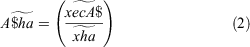
To estimate costs of monitoring koalas at landscape scales (A$ha), we first calculated estimates of average variable survey effort costs per hectare by using Spotlight, RPAS thermal imaging and refined SAT surveys for the Port Stephens population. Average per hectare survey effort costs ( ) are given by Eqn 2 (for detailed assumptions, limitations, site sizes and selection criteria, see Methods S3).
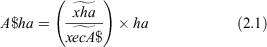
where  is the average cost of survey effort using each method across all survey sites (based on detailed person minutes converted to full-time equivalent effort in person hours) and
  is the average area in hectares for all survey sites in Port Stephens. The values used for analysis, including site size in hectares for all survey sites, were first reported in Witt et al. (2020) and are provided in Methods S3.
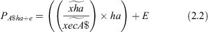
The survey effort costs at a landscape scale (A$ha) for koala habitat of any spatial area are given by substituting target areas in hectares (ha) into Eqn 2.1. More comprehensive monitoring program costs ( ) are given by also substituting equipment costs (E) into Eqn 2.2, as follows:
Cost-effectiveness of survey methods
We define cost-effectiveness ( ) as the relative dollar cost in person effort by using each unique survey method per average number of koalas detected per site, an approach adapted from Garden et al. (2007) and Perkins et al. (2013). We have chosen to use the number of direct koala detections as the proxy for representing the benefits to conservation practitioners of using each survey method. This proxy represents the benefit to conservation practitioners of greater fine-scale population data achieved through direct koala detection, which is the focus of the present study. Other analyses of cost-effectiveness could focus more thoroughly on per hectare costs or develop novel proxies to represent the benefit of more accurate monitoring information or trend data; however, here the proxy used in cost-effectiveness analysis was direct koala detection. The present analysis acknowledges that conservation practitioners may often need to directly locate and sight koalas, not just collect population information (although the authors note that direct detections using RPAS thermal imaging did result in the added benefit of more accurate density estimates against SAT; Witt et al. (2020).
Cost-effectiveness ( ) of Spotlight, RPAS thermal imaging and refined SAT surveys for koala monitoring was compared using the average number of koalas detected per dollar spent, which was given by Eqn 3, as follows:
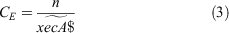
where  is the average number of koalas detected per site with each method independently and
  is the average cost of effort using each method per site (based on detailed person minutes converted to full-time equivalent effort in person hours). These values were first reported for each method in Witt et al. (2020); however, they differ in this investigation because of the focus on Port Stephens and the omission of non-relevant sites (Gilead, NSW). Detailed criteria of koala sightings/detections and values used for cost-effectiveness analyses are provided in Methods S3 and Table S5.
Survey effort and detection costs across koala population density
To compare survey effort and detection costs using Spotlight, RPAS thermal imaging and refined SAT surveys at different population densities, we first collated an ascending order scale of localised koala population density values obtained using a meta-review of relevant literature (Table S2). We then incorporated the values for the average effort (in person hours) required per successful koala detection,  , with each method in Port Stephens (known population density of 0.037 koalas ha−1; Witt et al. (2020) into a predictive variable scaled model in Microsoft® Excel (16.45) to infer changes in effort required for koala detection across all population densities on the scale.
  is given by Eqn 4, as follows:
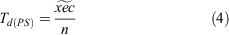
where  is the average effort (in person hours) per method per site recorded for Port Stephens and where
  is the average number of koalas detected per site with each method independently. For detailed reference values of effort for detection used in modelling, see Methods S3 and Table S5.
  values for each method were first reported in Witt et al. (2020), but differ in this investigation owing to the focus on Port Stephens and the omission of non-relevant sites.
Changes in effort ( ) required to detect koalas in a target population of any density (
 ) is given by Eqn 5, namely
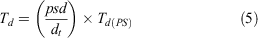
where  is the known naïve density for the Port Stephens koala population (0.037 koalas ha−1),
  is the target population density, and
  is the average survey effort in person hours required per koala detection in Port Stephens. Detection costs (
 ) can be compared at any population density on the scale by using the output value for
  and Eqn 6.

where  is the average effort in person hours required with each method until one koala is successfully detected and
  is the standardised hourly rate (A$40).
Using output data for each method from the model, we performed log-transformations of the average effort required per koala detection  and population density
  (Fig. S1). We used these log-transformations to generate algorithms that compare detection costs (
 ) at any population density
  , including those not represented on the scale (Fig. S1), providing the basis for a decision-making tool to compare survey effort and detection costs by using different survey methods across any population density. Output values represent a theoretical minimum estimate and do not account for changes in terrain, weather and other logistical factors characteristic of different habitat areas and landscapes. Estimates also do not account for potential travel costs.
Results
Cost comparison of survey methods
Costs to conduct surveys of the case study koala population differed considerably among Spotlight, RPAS thermal imaging and refined SAT surveys (Table 1). Total estimated costs to survey all sites over the survey period were highest for RPAS thermal imaging (A$53 485), followed by Spotlight surveys (A$7768) and lowest for refined SAT surveys (A$5148; Table 1). Equipment costs were highest for RPAS thermal imaging surveys (A$49 906), representing 93% of total estimated RPAS thermal imaging costs. For Spotlight surveys, equipment costs were estimated as A$2664, representing 34% of total costs. Equipment costs were lowest for SAT surveys (A$795), representing 15% of total costs (Table 1).

|
Estimated costs for labour (effort) differed substantially among methods (Table 1). Spotlight surveys required the greatest investment in labour on the basis of surveyor time (A$3112, representing 40% of total Spotlight costs), followed by refined SAT surveys (A$2361, 45.8% of total costs). Labour costs were lowest for RPAS thermal imaging surveys (A$1587), which accounted for 3% of total RPAS thermal imaging costs. These estimates represent 49% and 32% reductions in required labour costs against Spotlight and refined SAT surveys respectively (Table 1). Estimated travel costs (A$1992) were consistent among survey methods and were determined by the proximity to survey sites, as well as required personnel numbers for vehicle transport (Table 1).
Cost comparison of survey methods for theoretical long-term monitoring
Total costs for projected long-term (10 years) annually recurring monitoring of the Port Stephens population matching the survey effort achieved in Witt et al. (2020), but through replications over 17 weeks, would differ considerably among Spotlight, RPAS thermal imaging and refined SAT surveys (Fig. 1). RPAS thermal imaging surveys requiring a boom lift would incur the highest total 10-year program costs (>A$559 000). Conducting RPAS thermal imaging surveys with beyond-line-of-sight accreditation (currently required as of 2021 by federal Australian aviation regulations) and no boom lift (>A$196 000) would allow considerable reductions in total costs (Fig. 1). These lower-cost RPAS thermal imaging surveys would also provide considerable cost reductions against Spotlight (>A$309 000) and SAT surveys (>A$233 000) across equivalent or greater spatial areas (Fig. 1).

|
Koala monitoring costs at a landscape scale
Spotlight, RPAS thermal imaging and refined SAT surveys varied considerably on average survey effort costs per hectare (Table 2). RPAS thermal imaging surveys incurred the lowest average per hectare survey effort costs (A$3.84 ha−1) and provided the most efficient option at a landscape scale. Considerably higher average costs were incurred for Spotlight (A$6.09 ha−1) and SAT (A$5.03 ha−1; Table 2). Costs for RPAS thermal imaging surveys at a landscape scale would be, on average, 36% and 23% less costly than those for Spotlight and SAT respectively.

|
 ) and modelled costs of survey effort required to survey different spatial areas by using systematic spotlighting (Spotlight), remotely piloted aircraft system thermal imaging (RPAS thermal imaging) and the refined diurnal radial search component of the spot-assessment technique (SAT)
We successfully used the decision-making tool provided by Eqns 2.1 and 2.2 to estimate koala monitoring costs for varying scales, by using the case study of fire-affected koala habitat in the 2019/2020 Australian Black Summer Bushfires (Table 2). RPAS thermal imaging surveys had the lowest estimated survey effort costs at both scales compared; the fire affected 1.9 million hectares of ‘high or very high suitability’ koala habitat in eastern NSW (A$7.2 million) and the reported fire affected 7295.6 ha of ‘high priority koala habitat’ in the North Coast (NSW) Port Macquarie–Hastings Council region (A$28 015). Labour-intensive spotlight surveys would incur the highest survey effort costs at both scales (A$11.5 million and A$44 430). Refined SAT surveys would incur costs of A$9.5 million and A$36 697 at the scales compared here (Table 2).
At the smaller regional scale, as was observed in the Port Stephens case study population, total survey costs are highest for RPAS thermal imaging (A$77 921) against both Spotlight (A$47 094) and SAT (A$37 492) surveys when equipment costs are factored in (Tables 1, 2). In this case, survey method selection would consider other factors analysed here (e.g. long-term costs, cost-effectiveness, cost to detection, maximum potential detections; Figs 1–3, Table 3).

|

|
Cost-effectiveness of survey methods
RPAS thermal imaging surveys were the most cost-effective method for detecting koalas in the case study population (Table 3). RPAS thermal imaging detected the highest average number of koalas per dollar (0.0111 koalas dollar−1). Spotlight surveys required the highest average investment in survey effort across all sites and detected on average 0.0029 koalas per dollar. SAT surveys represent the least cost-effective survey method, detecting the least number of koalas per dollar spent (0.0007 koalas dollar−1; Table 3).
For RPAS thermal imaging surveys, when non-target species detections (n = 45) are included, the cost-effectiveness is greater, with increased animal detections per dollar spent (0.05) without the average cost of survey effort changing (Table 3).
Survey effort and detection costs across koala population density
Average survey effort required per koala detection increases with decreases in koala population density (koalas ha−1) using all methods (Fig. 2). RPAS thermal imaging surveys present the most efficient survey method, requiring the lowest effort to detect koalas across all population densities (~0.006–18 koalas per hectare; Table S2, Fig. 2). Spotlight surveys require more effort than RPAS thermal imaging, but provide an efficient alternative to SAT surveys across all population densities (Fig. 2). SAT represents the least efficient method for direct koala detection, requiring the highest effort to detect koalas across all population densities (Fig. 2).

|
Linear functions of average survey effort required per koala detection against koala population density (Fig. S1) provide the basis for a decision-making tool for practitioners to identify appropriate survey methods for efficient koala monitoring by estimating costs of successful detection (as well as labour and start-up equipment costs) by using Spotlight, RPAS thermal imaging and SAT surveys at different target-population densities (Fig. 3, Eqns 7–9). We have provided example calculations and comparisons of detection costs across population density in Fig. 3.
Discussion
We have provided clear evidence to conservation practitioners and stakeholders of the potential cost-effectiveness of remotely piloted aircraft system (RPAS) thermal imaging as a tool to monitor koala populations. Despite considerably higher start-up costs (>A$49 900; Table 1), RPAS thermal imaging provided greater overall cost-effectiveness against conventional field-based survey methods, including systematic spotlighting (Spotlight) and the refined diurnal radial search component of the spot-assessment technique (SAT). RPAS thermal imaging was considerably more cost-effective, detecting the highest number of koalas per dollar spent (0.0111 koalas dollar−1; Table 3). Our modelling of RPAS thermal imaging surveys with beyond line-of-sight accreditation and no boom lift shows the potential of this innovation to allow RPAS thermal imaging to provide further competitive costs over time, through long-term cost reductions to survey equivalent or greater spatial areas (Fig. 1). Longitudinal monitoring using RPAS thermal imaging would provide fine-scale population data at reduced or competitive costs, providing understanding of density over time and the short- or longer-term influence of management interventions (e.g. rehabilitation and release outcomes, habitat alterations and/or corridor usage, as well as response to pest control). Long-term cost modelling is likely to provide a conservative view, because modelling does not account for cost reductions for equipment and future technological advances (i.e. improvements in battery life, camera technology and thermal imaging capabilities, which may increase the number of koala detections as well as the maximum area that can be feasibly surveyed). RPAS thermal imaging also provides clear efficiency at landscape scales, with the lowest comparative per hectare survey effort costs (A$3.84/ha; Table 2), as well as efficiency across population density with the lowest survey effort costs to detect koalas at any population density (Figs 2, 3). Our analysis may provide the basis for a decision-making tool, currently lacking for koala conservation, that could allow practitioners to make meaningful economic comparisons of available survey methods for koala population monitoring.
Despite high up-front costs for equipment, licensing and training, our modelling suggests that RPAS thermal imaging may provide cost reductions or competitive costs against conventional survey methods within 3 years in annually recurring monitoring programs (Table 1, Fig. 1). RPAS thermal imaging would also provide greater data acquisition and fine-scale population data across long-term programs, with far more potential koala detections being expected, on the basis of higher detection rates relative to investment (Table 3). Successful monitoring programs are often long term (Woinarski 2018), which makes RPAS thermal imaging an attractive option for the repeated longitudinal monitoring and direct detections required to determine the on-going effectiveness of management interventions (Woinarski et al. 2018). High initial costs are characteristic of emergent technologies and will likely reduce over time with further advances in RPAS thermal imaging technology, as has been the case with audio detection technology for biodiversity monitoring (Lahoz-Monfort and Tingley 2018; Hill et al. 2019).
The emergence of RPAS thermal imaging technology has also resulted in the clear potential for reductions in survey effort and labour costs required to detect koalas across any population density and to survey koalas at a landscape scale (Tables 1, 2, Figs 2, 3). The costs of survey effort quickly become unfeasible using conventional methods at a low population density (Figs 2, 3), and across large spatial areas (Table 2), highlighting the importance of the emergent RPAS technology, which can cover large areas efficiently and greatly reduces time to detection (Witt et al. 2020; Beranek et al. 2021). These benefits are consistent with other recently emerging koala survey techniques, including audio detection technology and koala detection dogs, which both provided reduced survey effort requirements and increased efficiency against conventional scat-based techniques, particularly the SAT method (Cristescu et al. 2015; Law et al. 2020). We note that, in these cases, formal cost analyses were not conducted and that comprehensive economic and scientific comparisons of these emerging technologies and conventional field-based methods are required. A comprehensive cost analysis of other widely used field-based techniques (e.g. the line-transect method and double-count method) and these emerging techniques not analysed here could be conducted using the methodological and modelling approach provided in the present study and would make a useful contribution for national koala conservation efforts.
The efficiency of RPAS thermal imaging across population density has particular implications for monitoring regional and localised koala populations experiencing declines. There are often limited resources available for monitoring (even as a component of the large historic total investment in koala conservation; McAlpine et al. 2015; Office of Environment and Heritage 2018). Small stakeholders (e.g. community groups and regional councils) may not possess the resources to challenge or validate development approvals and impact assessments, monitor offset habitat, and ensure that mitigation measures and localised management interventions are actually effective (McAlpine et al. 2015; NSW Legislative Council 2020). Cost-effective and accurate tools may position stakeholders to conduct repeated population monitoring, respond to localised regional declines and threats and better target available conservation budgets (McAlpine et al. 2015; Lahoz-Monfort and Tingley 2018; Legge et al. 2018; NSW Legislative Council 2020).
The comparative costs of RPAS thermal imaging at a landscape scale were explored using the case study of large areas of fire-affected koala habitat (Table 2). Although the authors note that these comparisons are provided only as a hypothetical illustrative example and are limited by the need to consider sampling and targeting of unburnt refugia habitat, the analysis does effectively demonstrate the vast difference in potential survey effort costs when monitoring different spatial areas. RPAS thermal imaging had the lowest average survey effort costs per hectare, which would result in greatly reduced costs (in the millions of dollars) at a landscape scale over the 1.9 million hectares of fire-affected high- or very high-suitability koala habitat in NSW (Table 2). The high costs using conventional methods demonstrate the unfeasible costs associated with large bushfire events that threaten to exceed stretched conservation budgets and koala populations under anthropogenic climate change, highlighting the importance of cost-effective technologies that can efficiently cover large areas (Hennessy et al. 2005; Lucas et al. 2007; McAlpine et al. 2015; Wintle et al. 2019).
Cost implications would be different for fire-affected koala habitat at a localised scale. Total estimated costs to survey the fire-affected high-priority koala habitat in the North Coast Port Macquarie–Hastings Council Region were highest for RPAS thermal imaging because of high equipment costs at the outset (Tables 1, 2). Here, practitioners should consider the reductions in survey effort, greater and more efficient data acquisition, long-term cost reductions, and health, safety and logistical benefits of RPAS technology in fire-prone landscapes (NSW Legislative Council 2020). Similar monitoring decisions are likely to be required in other regional areas such as the North Coast, Blue Mountains, and Southern Highlands/Snowy Monaro regions following the 2019/2020 bushfires (NSW Legislative Council 2020). Regional stakeholders may routinely need to conduct monitoring pre-emptively or as bushfire response under a forecast of increasing bushfire severity as a result of anthropogenic climate change, highlighting the importance of transferrable and cost-effective monitoring techniques (Hennessy et al. 2005; Lucas et al. 2007; Dickman et al. 2020).
The unprecedented extent of the 2019/20 bushfires has challenged our understanding of koala populations and the species overall status; therefore, an unprecedented monitoring response is required (Dickman et al. 2020). This will help target management interventions to recover populations post-bushfire and help respond pre-emptively to future bushfires by understanding priority areas for protection (NSW Legislative Council 2020). Monitoring of this scale would usually call on indirect techniques, such as community surveying and/or participatory mapping (mapping using community or citizen science derived data); however, community-generated data may be hampered by bushfire impacts and these methods will carry unique challenges (Reed et al. 1990; Lunney et al. 1998; Curtin et al. 2001; Brown et al. 2018). Baseline data on declining koala populations were collected before these unprecedented bushfires with mostly limited monitoring programs, affecting the quality of baseline data (NSW Legislative Council 2020). This has prompted a national audit and updated census of koala populations by the Australian Federal Government, with A$2 million being provided for annual monitoring programs incorporating scat monitoring, drone technology, acoustic monitoring, detection dogs and citizen-science surveys (https://minister.awe.gov.au/ley/media-releases/18-million-koala-package-include-landmark-census). The proposed initial investment appears inadequate compared with the high costs we have demonstrated to survey large spatial areas (Table 2). Because it appears that there is no clear survey method preference for this monitoring program and there are no guiding frameworks for survey method selection, the choice of method (or combination of methods) could be precedent setting, and an adaptive approach may be required. Some available methods may be largely problematic (i.e. SAT with unreliable estimates of density, the potential accuracy of citizen science post-bushfire and the labour-intensive nature of some field-based methods to conduct a population census; Brown et al. 2018; Wilmott et al. 2019; Witt et al. 2020). Whereas there is a lack of evidence-based comparisons of monitoring options to guide selection (NSW Legislative Council 2020), although see Crowther et al. (2021) and Witt et al. (2020), on the basis of our modelling, drone thermal imaging technology may present an efficient method for repeatable, transferrable and accurate monitoring of koala populations and may deliver optimal data acquisition relative to the limited available budget.
SAT has been presented as an attractive option to public and private stakeholders for monitoring koala populations on the basis of low costs and claims to provide reliable population density estimates (Phillips et al. 2007; Phillips and Callaghan 2014; Phillips 2018). However, SAT did not provide reliable density estimates for the Port Stephens koala population and has limited potential to determine koala habitat usage and demographics (Witt et al. 2020). SAT is a less cost-effective option for direct koala detection and longitudinal monitoring of koala population density, with higher costs in the long term for less reliable data than with more accurate and efficient emerging technologies (Table 3, Figs 1–3). SAT remains a useful low-cost method for determining occupancy (Table 1; Witt et al. 2020); however, the method should not be used for longitudinal population monitoring where density or demographics are the goal (Witt et al. 2020). Our analysis reflects the risks to monitoring outcomes of selecting survey methods solely on the basis of low cost, rather than scientific accuracy or cost-effectiveness. Future investment into koala population monitoring would be better mobilised towards more accurate field-based methods such as Spotlighting, particularly for localised monitoring efforts, or towards cost-effective technologies such as drone thermal imaging, which provides reduced costs at landscape scales, and other benefits, including competitive long-term costs and far greater data acquisition.
Future innovation and further optimisation of protocols may further increase the usage of drone technology for wildlife monitoring. The koala’s iconic status may help draw resources for RPAS thermal imaging surveys to further develop the technology as well as provide important information on a greater number of co-occurring species that would not usually attract the same level of Government and private investment and do not typically receive the same monitoring adequacy or effort because of knowledge gaps, monitoring challenges and stretched conservation budgets (Woinarski et al. 2018). Collection of non-target co-occurring species data during koala monitoring is a promising innovation for drone technology (Beranek et al. 2021). It is important to note that the authors recognise that non-target species are also highly likely to be detected during surveys by using field-based methods and this would also increase the cost-effectiveness of these surveys. Successfully detecting macropods, other arboreal species and birds greatly increased the cost-effectiveness of RPAS thermal imaging surveys for koalas, without changing the survey effort or overall costs (Table 3). Applied research delivered an effective protocol to detect koalas using RPAS thermal imaging (Witt et al. 2020; Beranek et al. 2021). Applied research may also deliver RPAS thermal imaging protocols for other large-bodied arboreal (e.g. greater gliders, Petauroides volans, yellow-bellied gliders, Petaurus australis, pygmy three-toed sloths, Bradypus pygmaeus, or Bornean orangutan, Pongo pygmaeus) or ground-dwelling (e.g. macropods such as brush-tailed rock-wallaby, Petrogale penicillata) species. In addition, if these species are similarly labour-intensive to monitor with ground-based techniques, on the basis of the modelling here for the koala, RPAS thermal imaging may provide a more cost-effective survey option. However, this cannot be properly determined without a dedicated analysis and scientific comparisons. To recognise the potential of drone thermal imaging technology as an efficient multi-taxa ‘omnibus’ monitoring tool, practitioners should opportunistically focus efforts on systematic co-occurring species data collection during future koala surveys and use koala monitoring as leverage for applied research programs that include a dedicated focus on a wider range of species (Lahoz-Monfort and Tingley 2018).
Our analyses and modelling presented here provide the basic algorithms for a decision-making tool for practitioners to estimate survey effort and detection costs, as well as more detailed program costs for monitoring koala populations at different densities and landscape scales (Eqns 2.1, 2.2, Figs 2, 3). Using simple inputs such as target hectares to be monitored, known or suspected density of target population to be monitored and hourly rates to be paid for survey effort, our novel approach may offer practitioners a means to compare available survey techniques on their comparative costs. This includes efficiency across population density, which may provide practitioners realistic costs for koala detection for any localised population (Figs 2, 3), and survey effort costs at landscape scales, which may provide practitioners average expected costs for localised areas of habitat or large landscape-scale census surveys (Eqns 2.1, 2.2, Table 2). Our example calculations may ensure confidence in investing in the initially high-cost RPAS thermal imaging approach (Table 2, Figs 2, 3). These analyses and any future decision-making tool could be strengthened using data from different landscapes and habitat types (e.g. mountainous or rugged terrain such as that for the Blue Mountains koala population) and could add in other emerging survey methods (e.g. detection dogs and audio detection technology). Expanding these analyses and any future decision-making tool may ultimately provide different practitioner groups the autonomy to plan cost-effective koala monitoring programs for unique koala populations of varying density spread across large landscapes. Identifying survey method options that would offer the greatest cost-effectiveness for practitioners for the particular population or region requiring monitoring would maximise monitoring outcomes and data acquisition and create a sustainable strategy on which to implement targeted management interventions for localised koala populations, with long-term financial feasibility and maximum data acquisition.
Data availability
The data that support this study will be shared upon reasonable request to the corresponding author.
Conflicts of interest
The authors declare no conflicts of interest.
Declaration of funding
This research did not receive any specific funding, but the lead author Lachlan G. Howell acknowledges financial support through the Australian Government’s Research Training Program (RTP) Scholarship.
Acknowledgements
The authors thank Dr Kim Colyvas at the University of Newcastle for advice on the modelling presented in this study. The authors also acknowledge Emeritus Professor John C. Rodger for providing feedback on an early draft of this paper. The authors also thank the anonymous reviewers for greatly improving the paper.
References
Beranek, C. T., Roff, A., Denholm, B., Howell, L. G., and Witt, R. R. (2021). Trialling a real-time drone detection and validation protocol for the koala (Phascolarctos cinereus). Australian Mammalogy 43, 260–264.Brown, G., McAlpine, C., Rhodes, J., Lunney, D., Goldingay, R., Fielding, K., Hetherington, S., Hopkins, M., Manning, C., and Wood, M. (2018). Assessing the validity of crowdsourced wildlife observations for conservation using public participatory mapping methods. Biological Conservation 227, 141–151.
| Assessing the validity of crowdsourced wildlife observations for conservation using public participatory mapping methods.Crossref | GoogleScholarGoogle Scholar |
Burke, C., Rashman, M., Wich, S., Symons, A., Theron, C., and Longmore, S. (2019). Optimizing observing strategies for monitoring animals using drone-mounted thermal infrared cameras. International Journal of Remote Sensing 40, 439–467.
| Optimizing observing strategies for monitoring animals using drone-mounted thermal infrared cameras.Crossref | GoogleScholarGoogle Scholar |
Corcoran, E., Denman, S., Hanger, J., Wilson, B., and Hamilton, G. (2019). Automated detection of koalas using low-level aerial surveillance and machine learning. Scientific Reports 9, 3208.
| Automated detection of koalas using low-level aerial surveillance and machine learning.Crossref | GoogleScholarGoogle Scholar | 30824795PubMed |
Cristescu, R. H., Foley, E., Markula, A., Jackson, G., Jones, D., and Frere, C. (2015). Accuracy and efficiency of detection dogs: a powerful new tool for koala conservation and management. Scientific Reports 5, 8349.
| Accuracy and efficiency of detection dogs: a powerful new tool for koala conservation and management.Crossref | GoogleScholarGoogle Scholar | 25666691PubMed |
Crowther, M. S., Dargan, J. R., Madani, G., Rus, A. I., Krockenberger, M. B., McArthur, C., Moore, B. D., Lunney, D., and Mella, V. S. A. (2021). Comparison of three methods of estimating the population size of an arboreal mammal in a fragmented rural landscape. Wildlife Research 48, 105–114.
Curtin, A., Lunney, D., and Matthews, A. (2001). A survey of a low-density koala population in a major reserve system, near Sydney, New South Wales. Australian Mammalogy 23, 135–144.
| A survey of a low-density koala population in a major reserve system, near Sydney, New South Wales.Crossref | GoogleScholarGoogle Scholar |
Department of Planning, Industry and Environment (2020). NSW Government Response: Inquiry into koala populations and habitat in New South Wales. Sydney. Available at https://www.parliament.nsw.gov.au/lcdocs/inquiries/2536/Koala%20populations%20and%20habitat%20in%20New%20South%20Wales%20-%20Report%203%20-%20Government%20response.pdf.
Dickman, C., Driscoll, D., Garnett, S., Keith, D., Legge, S., Lindenmayer, D., Maron, M., Reside, A., Ritchie, E., Watson, J., Wintle, B., and Woinarski, J. (2020). After the catastrophe: a blueprint for a conservation response to large-scale ecological disaster, Threatened Species Recovery Hub, January 2020. Available at https://www.nespthreatenedspecies.edu.au/media/0akfale0/after-the-catastrophe-report_v5.pdf.
Dique, D. S., de Villiers, D. L., and Preece, H. J. (2003). Evaluation of line-transect sampling for estimating koala abundance in the Pine Rivers Shire, south-east Queensland. Wildlife Research 30, 127–133.
| Evaluation of line-transect sampling for estimating koala abundance in the Pine Rivers Shire, south-east Queensland.Crossref | GoogleScholarGoogle Scholar |
Ellis, W., FitzGibbon, S., Melzer, A., Wilson, R., Johnston, S., Bercovitch, F., Dique, D., and Carrick, F. (2013). Koala habitat use and population density: using field data to test the assumptions of ecological models. Australian Mammalogy 35, 160–165.
| Koala habitat use and population density: using field data to test the assumptions of ecological models.Crossref | GoogleScholarGoogle Scholar |
Garden, J. G., McAlpine, C. A., Possingham, H. P., and Jones, D. N. (2007). Using multiple survey methods to detect terrestrial reptiles and mammals: What are the most successful and cost-efficient combinations? Wildlife Research 34, 218–227.
| Using multiple survey methods to detect terrestrial reptiles and mammals: What are the most successful and cost-efficient combinations?Crossref | GoogleScholarGoogle Scholar |
Hamilton, G., Corcoran, E., Denman, S., Hennekam, M. E., and Koh, L. P. (2020). When you can’t see the koalas for the trees: using drones and machine learning in complex environments. Biological Conservation 247, 108598.
| When you can’t see the koalas for the trees: using drones and machine learning in complex environments.Crossref | GoogleScholarGoogle Scholar |
Hennessy, K., Lucas, C., Nicholls, N., Bathols, J., Suppiah, R., and Ricketts, J. (2005). Climate change impacts on fire-weather in south-east Australia. CSIRO Marine and Atmospheric Research. (Melbourne). Available at http://www.cmar.csiro.au/e-print/open/hennessykj_2005b.pdf.
Hill, A. P., Prince, P., Snaddon, J. L., Doncaster, C. P., and Rogers, A. (2019). AudioMoth: a low-cost acoustic device for monitoring biodiversity and the environment. HardwareX 6, e00073.
| AudioMoth: a low-cost acoustic device for monitoring biodiversity and the environment.Crossref | GoogleScholarGoogle Scholar |
Hodgson, J. C., Mott, R., Baylis, S. M., Pham, T. T., Wotherspoon, S., Kilpatrick, A. D., Raja Segaran, R., Reid, I., Terauds, A., and Koh, L. P. (2018). Drones count wildlife more accurately and precisely than humans. Methods in Ecology and Evolution 9, 1160–1167.
| Drones count wildlife more accurately and precisely than humans.Crossref | GoogleScholarGoogle Scholar |
Hundloe, T., and Hamilton, C. (1997). Koalas and tourism: an economic evaluation. Available at https://australiainstitute.org.au/report/koalas-and-tourism-an-economic-evaluation/.
Lahoz-Monfort, J. J., and Tingley, R. (2018). The technology revolution: improving species detection and monitoring using new tools and statistical methods. In ‘Monitoring Threatened Species and Ecological Communities’. (Eds S. Legge, D. Lindenmayer, N. Robinson, B. Scheele, D. Southwell, and B. Wintle.) pp. 303–313. (CSIRO Publishing: Melbourne, Vic., Australia.)
Law, B. S., Brassil, T., Gonsalves, L., Roe, P., Truskinger, A., and McConville, A. (2018). Passive acoustics and sound recognition provide new insights on status and resilience of an iconic endangered marsupial (koala Phascolarctos cinereus) to timber harvesting. PLoS One 13, e0205075.
| Passive acoustics and sound recognition provide new insights on status and resilience of an iconic endangered marsupial (koala Phascolarctos cinereus) to timber harvesting.Crossref | GoogleScholarGoogle Scholar | 30379836PubMed |
Law, B., Gonsalves, L., Bilney, R., Peterie, J., Pietsch, R., Roe, P., and Truskinger, A. (2020). Using passive acoustic recording and automated call identification to survey koalas in the southern forests of New South Wales. Australian Zoologist 40, 477–486.
| Using passive acoustic recording and automated call identification to survey koalas in the southern forests of New South Wales.Crossref | GoogleScholarGoogle Scholar |
Legge, S., Robinson, N., Lindenmayer, D., Scheele, B., Southwell, D., and Wintle, B. (2018). ‘Monitoring Threatened Species and Ecological Communities.’ (CSIRO Publishing: Melbourne, Vic., Australia.)
Leigh, C., Heron, G., Wilson, E., Gregory, T., Clifford, S., Holloway, J., McBain, M., Gonzalez, F., McGree, J., and Brown, R. (2019). Using virtual reality and thermal imagery to improve statistical modelling of vulnerable and protected species. PLoS One 14, e0217809.
| Using virtual reality and thermal imagery to improve statistical modelling of vulnerable and protected species.Crossref | GoogleScholarGoogle Scholar | 31825957PubMed |
Lucas, C., Hennessy, K., Mills, G., and Bathols, J. (2007). Bushfire weather in southeast Australia: recent trends and projected climate change impacts. Consultancy report prepared for the Climate Institute of Australia by the Bushfire Cooperative Research Centre. Available at https://publications.csiro.au/rpr/pub?list=BRO&pid=procite:5910842c-f62e-4006-b88f-1055d8e981fa.
Lunney, D., Phillips, S., Callaghan, J., and Coburn, D. (1998). Determining the distribution of koala habitat across a shire as a basis for conservation: a case study from Port Stephens, New South Wales. Pacific Conservation Biology 4, 186–196.
| Determining the distribution of koala habitat across a shire as a basis for conservation: a case study from Port Stephens, New South Wales.Crossref | GoogleScholarGoogle Scholar |
Markwell, K. (2020). Getting close to a national icon: an examination of the involvement of the koala (Phascolarctos cinereus) in Australian tourism. Tourism Recreation Research 46, 473–486.
McAlpine, C., Lunney, D., Melzer, A., Menkhorst, P., Phillips, S., Phalen, D., Ellis, W., Foley, W., Baxter, G., De Villiers, D., Kavanagh, R., Adams-Hosking, C., Todd, C., Whisson, D., Molsher, R., Walter, M., Lawler, I., and Close, R. (2015). Conserving koalas: a review of the contrasting regional trends, outlooks and policy challenges. Biological Conservation 192, 226–236.
| Conserving koalas: a review of the contrasting regional trends, outlooks and policy challenges.Crossref | GoogleScholarGoogle Scholar |
Nolan, R. H., Boer, M. M., Collins, L., Resco de Dios, V., Clarke, H., Jenkins, M., Kenny, B., and Bradstock, R. A. (2020). Causes and consequences of eastern Australia’s 2019–20 season of mega‐fires. Global Change Biology 26, 1039–1041.
| Causes and consequences of eastern Australia’s 2019–20 season of mega‐fires.Crossref | GoogleScholarGoogle Scholar | 31916352PubMed |
NSW Legislative Council (2020). Koala populations and habitat in New South Wales/Portfolio Committee No. 7 – Planning and Environment. Sydney, NSW, Australia. Available at https://www.parliament.nsw.gov.au/lcdocs/inquiries/2536/Koala%20populations%20and%20habitat%20in%20New%20South%20Wales%20-%20Report%203.pdf.
Office of Environment and Heritage (2018). NSW Koala Strategy. Available at https://www.environment.nsw.gov.au/research-and-publications/publications-search/nsw-koala-strategy.
Perkins, G. C., Kutt, A. S., Vanderduys, E. P., and Perry, J. J. (2013). Evaluating the costs and sampling adequacy of a vertebrate monitoring program. Australian Zoologist 36, 373–380.
| Evaluating the costs and sampling adequacy of a vertebrate monitoring program.Crossref | GoogleScholarGoogle Scholar |
Phillips, S. (2018). Kings Hill, Tomago and Medowie Koala Hub Assessment: draft report to Port Stephens Council. Uki, NSW, Australia.
Phillips, S., and Callaghan, J. (2011). The Spot Assessment Technique: a tool for determining localised levels of habitat use by koalas Phascolarctos cinereus. Australian Zoologist 35, 774–780.
| The Spot Assessment Technique: a tool for determining localised levels of habitat use by koalas Phascolarctos cinereus.Crossref | GoogleScholarGoogle Scholar |
Phillips, S., and Callaghan, J. (2014). What faecal pellet surveys can and can’t reveal about the ecology of koalas Phascolarctos cinereus II: an interim response to Woosnam–Merchez et al. (2013). Available at https://www.biolink.com.au/sites/www.biolink.com.au/files/publications/Response%20to% 20Woosnam-Merchez.pdf.
Phillips, S., Hopkins, M., and Callaghan, J. (2007). Koala Habitat and Population Assessment for the Gold Coast City LGA: final report to Gold Coast City Council. Uki, NSW, Australia.
Reed, P., Lunney, D., and Walker, P. 1990. Survey of the koala Phascolarctos cinereus (Goldfuss) in New South Wales (1986–87), with an ecological interpretation of its distribution. In ‘Biology of the Koala’. (Eds A. K. Lee, K. A. Handasyde, and G. D. Sanson.) pp. 55–74. (Surrey Beatty: Sydney, NSW, Australia.)
Rhodes, J. R., Tyre, A. J., Jonzén, N., McAlpine, C. A., and Possingham, H. P. (2006). Optimizing presence–absence surveys for detecting population trends. The Journal of Wildlife Management 70, 8–18.
| Optimizing presence–absence surveys for detecting population trends.Crossref | GoogleScholarGoogle Scholar |
Rhodes, J., Hood, A., Alistair, M., and Mucci, A. (2017). Queensland Koala Expert Panel: a new direction for the conservation of koalas in Queensland. A report to the Minister for Environment and Heritage Protection. Available at https://environment.des.qld.gov.au/__data/assets/pdf_file/0031/88582/qld-koala-expert-panel-report-2017.pdf.
Tisdell, C., and Nantha, H. S. (2006). Comparison of funding and demand for the conservation of the charismatic koala with those for the critically endangered wombat Lasiorhinus krefftii. In ‘Vertebrate Conservation and Biodiversity’. (Eds D. L. Hawksworth, and A. T. Bull.) pp. 435–455. (Springer.)
Wilmott, L., Cullen, D., Madani, G., Krogh, M., and Madden, K. (2019). Are koalas detected more effectively by systematic spotlighting or diurnal searches? Australian Mammalogy 41, 157–160.
| Are koalas detected more effectively by systematic spotlighting or diurnal searches?Crossref | GoogleScholarGoogle Scholar |
Wintle, B. A., Cadenhead, N. C. R., Morgain, R. A., Legge, S. M., Bekessy, S. A., Cantele, M., Possingham, H. P., Watson, J. E. M., Maron, M., and Keith, D. A. (2019). Spending to save: what will it cost to halt Australia’s extinction crisis? Conservation Letters 12, e12682.
| Spending to save: what will it cost to halt Australia’s extinction crisis?Crossref | GoogleScholarGoogle Scholar |
Witt, R. R., Beranek, C. T., Howell, L. G., Ryan, S. A., Clulow, J., Jordan, N. R., Denholm, B., and Roff, A. (2020). Real-time drone derived thermal imagery outperforms traditional survey methods for an arboreal forest mammal. PLoS One 15, e0242204.
| Real-time drone derived thermal imagery outperforms traditional survey methods for an arboreal forest mammal.Crossref | GoogleScholarGoogle Scholar | 33196649PubMed |
Woinarski, J. C. Z. (2018). A framework for evaluating the adequacy of monitoring programs for threatened species. In ‘Monitoring Threatened Species and Ecological Communities’. pp. 13–20. (CSIRO Publishing: Melbourne, Vic., Australia.)
Woinarski, J., and Burbidge, A. A. (2016). Phascolarctos cinereus. The IUCN Red List of Threatened Species 2016:e T16892A21960344.
Woinarski, J. C. Z., Burbidge, A. A., and Harrison, P. L. (2018). The extent and adequacy of monitoring for Australian threatened mammal species. In ‘Monitoring Threatened Species and Ecological Communities’. pp. 21–42. (CSIRO Publishing: Melbourne, Vic., Australia.)