

Monitoring the Endangered wiliji (Petrogale lateralis kimberleyensis) on Nyikina Mangala Country (Western Australia) using camera traps
Tyrone H. Lavery A B * , Darraga John Watson C , B F , Shaquille Millindee C , David Pearson G , Tyrese Skeen C , Daniel Smuskowitz C , Darren Southwell F , Albert Watson C , Alexander Watson E , William Watson C , Nick Weigner E , John Woinarski H , Leigh-Ann Woolley E H and David B. Lindenmayer B
 A
B
C
D
E
F
G
H
Abstract
Nyikina Mangala Traditional Owners regard the Endangered wiliji (Petrogale lateralis kimberleyensis), and the rocky landscape it inhabits, as significant cultural entities. A cross-cultural partnership was established in 2012 between the Nyikina Mangala Rangers and WWF-Australia to look after the wiliji. In the aspect of the project described here, camera traps were used to investigate wiliji presence and condition. As one of the biocultural indicators of rocky country health, rangers wanted to estimate wiliji numbers to evaluate the effectiveness of threat management actions implemented to heal rocky country, such as right-way fire and feral predator control. Specialist data modelling support was provided by co-authored scientists to here produce the methods and results of this study within the broader context of assessing and helping to guide management of this important species.
To inform and refine the Nyikina Mangala Rangers’ wiliji management, through interpretation of a camera trap monitoring program.
Since 2012, Nyikina Mangala Rangers have collected camera trap data across three rocky outcrops on Country. Using these data, we estimated probabilities of detecting wiliji and co-occurring mammals at these sites. We calculated relative abundance indices for wiliji and used unmarked spatial capture recapture models to estimate abundance at one site (Malarabba) in three different years.
Detections of wiliji, langurru (Trichosurus vulpecula), and jamandi (Osphranter robustus) varied across the three outcrops. Between 18 and 45 nights were needed at different sites to be 95% certain that wiliji were not present. Our median wiliji abundance estimates at Malarabba were 75 (2018), 160 (2021), and 108 (2023). These corresponded with relative abundance indices. Lower abundance was detected following fire that burned more than 75% of Malarabba in November 2017 and 2023. Three wiliji predators, namely, dingo (Canis familiaris), feral cat (Felis catus), and red fox (Vulpes vulpes), were detected.
Abundance estimates for Malarabba fell either side of the only published estimate for this population (~100 individuals). Accuracy could be improved by determining specific model priors from wiliji movement data. Interpretation of these data have helped support and refine management.
Cross-cultural partnerships between Indigenous organisations, and non-Indigenous researchers can successfully deliver multiple objectives if carefully guided by Indigenous priorities. Camera traps present some key advantages for monitoring and managing wiliji (e.g. simultaneous collection of data on predators and competitors). This approach will benefit long-term conservation of wiliji, aligned with Traditional Owner aspirations to look after rocky country.
Keywords: Australia, capture–recapture, conservation, extinction, Healthy Country, mammal, rocky country, threatened, unmarked.
Introduction
Globally biological diversity is declining at an accelerating pace, with approximately 1 million species facing extinction, many within decades (IPBES 2019). Australia, with its highly endemic biota, range of major environmental threats, and poor extinction record, features prominently in this global picture (Legge et al. 2023). Threatened species monitoring is a crucial part of efforts to halt biodiversity decline (Legge et al. 2018). When designed well, monitoring programs provide vital information on population trends, key threats, and the responses needed to manage and mitigate those threats (Legge et al. 2018; Garnett et al. 2019; Lindenmayer et al. 2020). Unfortunately, monitoring is often a low priority in threatened species management (Lindenmayer et al. 2020). Moreover, when monitoring programs are established, their design (e.g. monitoring methods, longevity, and periodicity) and allocation of resources are often inadequate to detect declines or prompt the management responses needed to stem them (Lindenmayer and Likens 2018; Lindenmayer et al. 2020).
Indigenous people maintain land rights over some of the most species-rich and intact landscapes on Earth and, as such, play a disproportionate role in global conservation and monitoring efforts (Renwick et al. 2017; Garnett et al. 2018; Schuster et al. 2019). Over 50% of Australia’s terrestrial land area is covered by some form of Indigenous land tenure (freehold and exclusive Native Title rights, co-management partnerships in protected areas, and Indigenous land-use agreements) (Renwick et al. 2017). Almost three quarters of the 272 terrestrial or freshwater vertebrates listed as threatened under Australia’s Environmental Protection and Biodiversity Conservation Act 1999 (EPBC Act) have ranges that overlap with these lands (Renwick et al. 2017). This proportion is even greater for Australia’s threatened mammals, with 82% of species occurring on Indigenous land tenures (Renwick et al. 2017).
The expansion of Indigenous land tenures in Australia has coincided with greater recognition of the importance of Indigenous knowledge and management systems for conserving threatened species (Ens et al. 2015; Leiper et al. 2018). Indigenous land management goals frequently overlap with those of conservation biologists, and successful partnerships between Indigenous people and conservation scientists can be extremely powerful for conservation (Ziembicki et al. 2013; Ward Fear et al. 2019; Lavery et al. 2020). Furthermore, the number of Indigenous ranger groups is growing, and monitoring programs led by Indigenous knowledge and the re-assertion of Indigenous jurisdiction and management over Country are also expanding (Zurba et al. 2019; Reed et al. 2021).
Rock-wallabies (Petrogale spp.) are one of Australia’s most speciose marsupial radiations, comprising 25 taxa (17 species and 8 subspecies). The genus occurs discontinuously across much of the continent (Eldridge 2008; Eldridge et al. 2010; Potter et al. 2014; Lavery et al. 2021). Over half the taxa (13 of 25 taxa) are classified as threatened under the EPBC Act, and as large, charismatic mammals, they are regularly identified by government agencies and non-government organisations as important priorities for conservation (e.g. DCCEEW 2008; Read and Ward 2011; Pearson 2013; Commonwealth of Australia 2015). Rock-wallabies, and the rocky landscape features they inhabit, also represent significant cultural entities for many of the Indigenous peoples on whose Country they occur (Pearson 1997; Telfer and Garde 2006; Muhic et al. 2012; Turpin et al. 2018). Wiliji (Petrogale lateralis kimberleyensisEldridge and Potter 2019) is one such example. This subspecies is classified as Endangered under Australia’s environmental legislation, the Environment Protection and Biodiversity Conservation Act 1999 (DCCEEW 2020) and the WA Biodiversity Conservation Act 2016 and restricted to a few scattered sandstone ranges and rocky outcrops in the southern Kimberley region of north-western Australia, all of which exist within the Nyikina Mangala Native Title Determination area. Subsequent to the granting of Native Title in 2014, the Walalakoo Aboriginal Corporation was established as a key political, social and economic body to oversee management of the Nyikina Mangala Native Title Determination area and actively represent Nyikina Mangala Peoples. The Nyikina Mangala Rangers (including some of the co-authors of this paper) are the operating ranger arm of Walalakoo Aboriginal Corporation. Working alongside Senior Traditional Owners, they are responsible for implementing management activities over approximately 26,215 km2 of culturally and environmentally significant Country. Rangers employ a range of Traditional Knowledge and contemporary science techniques to progress conservation and land management objectives as informed by Traditional Owner cultural, environmental and social priorities (Walalakoo Aboriginal Corporation 2016).
Camera trap surveys are increasingly used for wildlife surveys and monitoring and are now a favoured method across a wide array of taxa and environments (Rovero and Zimmermann 2016). Camera traps have proven popular because they can collect data over long periods, have minimal animal welfare impacts, and can collect data on co-occurring threats such as feral predators and herbivores. Since 2012, the Nyikina Mangala Rangers have conducted a survey program for wiliji by using camera traps and faecal pellet counts (Nyikina Mangala Rangers 2015; Nyikina Mangala Rangers, WWF Australia 2018, 2022). These surveys have been shown to be successful at monitoring presence–absence of wiliji on three separate escarpments. However, estimating abundance has been shown to be more difficult and options to track population changes have been limited. In a collaboration established by Walalakoo Aboriginal Corporation and at the invitation of the community, the Nyikina Mangala Rangers, WWF-Australia, and invited scientists collaborated to tackle this issue. This paper represents one of the outcomes of this collaboration.
Management priorities have been described by Nyikina Mangala Traditional Owners in the Walalakoo Healthy Country Plan, which articulates approaches to protecting and managing rich natural and cultural values in the Nyikina Mangala Native Title Determination area (Walalakoo Aboriginal Corporation 2016). Healthy Country planning follows an adaptation of the Open Standards for the Practice of Conservation (Moorcroft et al. 2012). Wiliji is named in the Walalakoo Healthy Country Plan as a species of interest because of cultural significance, as well as recognition of its conservation status and regional endemism. The Nyikina Mangala Rangers have an on-going partnership with WWF-Australia, and have invested substantial time and effort in locating key wiliji colonies and managing critical threats as part of a broader wiliji management program. This partnership was carefully developed to respect Nyikina Mangala cultural authority and Indigenous Cultural Intellectual Property (ICIP). Of importance was an inclusive and collaborative conservation approach, where continuous attention to colonial power relationalities and best practice cross-cultural protocols and guidelines helped facilitate Indigenous-led ownership of the program (e.g. Austin et al. 2019; Cooke et al. 2022). As part of this approach, decision-making was retained by Elders, Traditional Owners and the Nyikina Mangala Rangers to provide direction for the wiliji program, thus ensuring Indigenous-led program dimensions, such as governance, project strategy, project co-design, project monitoring and adaptive management. In response to this direction, WWF-Australia contributed contemporary science conservation project to the co-design, continuously deferring back to Traditional Owners and rangers through an agreed governance structure facilitating information being co-developed by rangers and WWF-Australia staff, then taken by the rangers to their Healthy Country Committee for advice and recommendations to ensure that the program correctly embodied Traditional Owner objectives and maintained Indigenous-led control. Cultural advisors, through Walalakoo Aboriginal Corporation’s governance structures, worked with the rangers and Healthy Country Committee to make final decisions on priorities, survey design, management activities, workplans and budget expenditure.
Here, our collaboration was aimed at further developing wiliji monitoring work with camera traps, as led by the Nyikina Mangala Rangers. To inform their current monitoring program, as well as a Walalakoo wiliji management plan under development, the rangers wanted the following three main questions answered: (1) which animals were most commonly detected by cameras on Malarabba, Grant, and Edgar Ranges; (2) how long should cameras be deployed at different sites to make sure wiliji are detected; and (3) how many wiliji were at Malarabba during different survey times? To answer these questions, Walalakoo Aboriginal Corporation asked co-authored scientists with specialist analysis skills to produce the Materials and methods and Results sections of this publication. Interpretation of results from a scientific perspective are included in the Discussion, together with Indigenous authors’ perspectives, contextualised within challenges and opportunities presented by cross-cultural collaborations.
Materials and methods
Study area
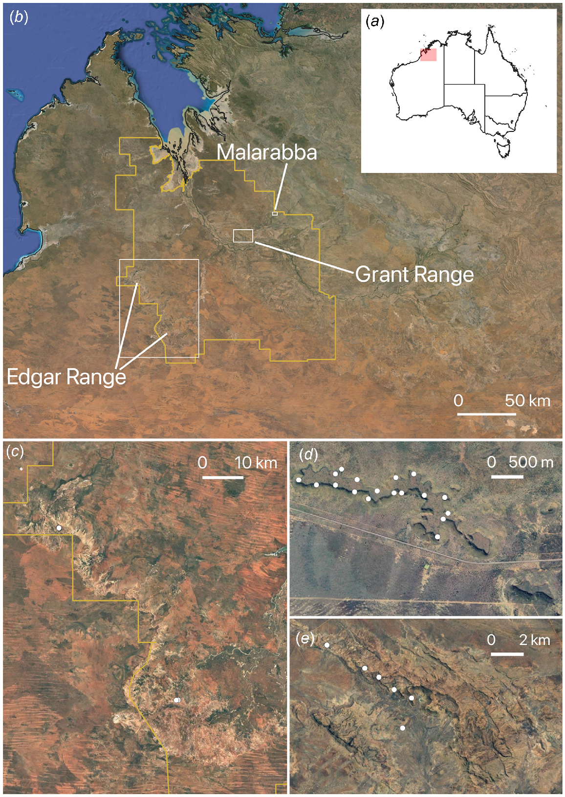
Petrogale lateralis kimberleyensis (wiliji) occurs as three populations on Malarabba (Erskine Range), as well as the Grant and Edgar Ranges, all within the Nyikina Mangala Native Title Determination area (Fig. 1). A historic population at Mount Wynne, the type locality, is now considered extinct (Pearson 2013). The total area of occupancy for the subspecies is unknown but is less than 500 km2 and is likely to be ~200 km2 (Woinarski et al. 2014, Threatened Species Scientific Committee 2021). Malarabba is a low sandstone escarpment vegetated with Acacia spp. and Santalum spp. shrubland with occasional Ficus spp. (Pearson and Kinnear 1996). Deep caves and fissures are common and the highest density of wiliji are believed to exist on Malarabba (Nyikina Mangala Rangers, WWF Australia 2018). The Edgar Range is the largest of the three ranges, and wiliji have been found at three locations in the most extensive areas of available habitat on the range. It consists of high sandstone cliffs, with occasional gorges that support more mesic vegetation where wiliji are more abundant. Occasional boulder piles occur along the escarpment (arising from cliff falls), and scree slopes support hummock grasslands and occasional Ficus spp. (Pearson and Kinnear 1996). Most of the habitat provided by the Edgar Range is less suited to wiliji (Nyikina Mangala Rangers, WWF Australia 2018). Grant Range has few crevices and caves used by wiliji during the day and preliminary surveys on the Grant Range have found that wiliji are irregularly distributed there in low numbers (Nyikina Mangala Rangers 2015). Major threats to this subspecies are believed to be inappropriate fire regimes, habitat degradation by introduced herbivores, and predation by feral predators (Pearson 2013; Woinarski et al. 2014; NESP TSR Hub 2019; D. Watson, pers. comm.). Late dry-season wildfires affected more than 75% of Malarabba in November 2017 and again in November 2023.
Location of the case study region (a) in north-western Australia; (b) the Edgar and Grant Range and Malarabba (Erskine) in relation to Nyikina Mangala Native Title determination area (yellow polygon); and camera trap locations (white points) in the (c) Edgar Range surveys, (d) Malarabba surveys, and (e) Grant Range surveys.
Data collection
Commencing in 2012, Walalakoo Aboriginal Corporation and Nyikina Mangala Rangers have undertaken surveys for wiliji using camera traps, and faecal pellets surveys at Malarabba and the Edgar and Grant Ranges (Table 1). Faecal pellet surveys were used only to gauge presence or absence of wiliji. No fixed, repeated measure plots were established, and no estimates of faecal pellet numbers per area were made. Cameras were installed primarily to detect presence–absence of animals at Grant and Edgar Ranges, and denser arrays were deployed at Malarabba to attempt to count the minimum number of animals known to be alive at each individual camera trap location (Nyikina Mangala Rangers, WWF Australia 2018, 2021). Camera trap arrays included sampling on top of escarpments, along scree slopes, and in the adjacent lowlands, providing wiliji detection data across the range of landscape features present on the rocky outcrops. One camera trap (Reconyx HC600) was deployed at each location at a site and mounted on star pickets, trees or rocks at a height of approximately 1 m above the ground. A universal bait consisting of a mixture of peanut butter and oats was placed in a ventilated PVC bait holder approximately 1.5–2.0 m in front of the camera. Camera triggers were set to high sensitivity, five pictures per trigger with rapid fire intervals, and no delay between triggers.
| Site | Method | Time period | Survey details | Approximate effort | |
|---|---|---|---|---|---|
| Malarabba | Camera traps | April 2013 | Six cameras | 156 trap nights | |
| May–June 2018 | 35 cameras | 467 trap nights | |||
| June–Aug 2021 | 38 cameras | 1486 trap nights | |||
| Nov 2023–Feb 2024 | 40 cameras | 2170 trap nights | |||
| Faecal pellets | April 2013 | Presence/absence | Six area searches | ||
| May–June 2018 | Presence/absence | Seven area searches | |||
| Edgar Ranges | Camera traps | April 2013 | 10 cameras | ~200 trap nights | |
| May–June 2015 | Five cameras | 107 trap nights | |||
| July–Aug 2016 | 13 cameras | 219 trap nights | |||
| Faecal pellets | April 2013 | Presence/absence | Five area searches | ||
| Sep 2015 | Presence/absence | 23 area searches | |||
| June 2017 | Presence/absence | Four area searches | |||
| Grant Range | Camera traps | Apr–June 2015 | Six cameras | 202 trap nights | |
| July–Oct 2022 | 34 cameras | 1346 trap nights | |||
| Faecal pellets | Apr–Jun 2015 | Presence/absence | 18 area searches |
We identified an appropriate time interval to approximate the independence of wiliji detection events in our data by using lorelograms (Iannarilli et al. 2019) (Supplementary Fig. S1). Our results indicated that 30 min was an appropriate interval, and we calculated relative abundance indices and abundance from our 2015–2024 Malarabba datasets by removing repeat wiliji detections within 30-min intervals. We applied this same 30-min interval to other species when comparing numbers of detection events across site surveys.
Data analysis
Probability of detection
We modelled nightly detection probabilities for wiliji, langurru (common brushtail possum), jamandi (euro), feral cat, and dingo by using sequences of camera trap detection histories from the Grant Range (2015), Edgar Range (2016), and Malarabba (2018) (Table 1), by using the package unmarked (ver. 1.5.0, https://cran.r-project.org/web/packages/unmarked/index.html; Fiske and Chandler 2011) implemented in R (R Core Team 2022). Each species was modelled as the proportion of nights it was detected in a survey, as a two-vectored response variable (number of nights they were, and were not detected over 70 nights of sampling), by using a binomial distribution in a fixed number of Bernoulli trials (Crawley 2012), following the methods of Moore et al. (2020a). Model outputs were presented as the probability a species will be detected on a randomly selected night of a camera-trap survey at each of the three sites. For the three rocky outcrops, we also generated cumulative nightly detectability curves for wiliji on the basis of the detectability estimates derived from our models, and calculated the minimum number of nights needed to be 95% confident that a site is unoccupied by wiliji.
Wiliji abundance at Malarabba
Using the decision tree prepared by Gilbert et al. (2021), we identified two appropriate methods to report our wiliji detection data. First, we calculated relative abundance indices (number of detection events/100 trap nights). The potential pitfalls with relative indices (RAI) are well-acknowledged (e.g. Sollmann et al. 2013). For example, changes in detection rates of a species over time and seasons can lead to false inferences about population trends. However, they can prove useful when they correlate with absolute abundance and can act as a viable guide for management or detecting environmental differences (Gilbert et al. 2021). We employed non-parametric bootstrapping (Efron and Tibshirani 1994), resampling camera locations with replacement to calculate RAI variance from 100,000 resampled estimates for each survey location and year.
In our second approach, we applied an analytical framework to estimate abundance and density in unmarked populations. At least six categories of analytical framework are available, each with their own explicit assumptions, and requirements for sampling design and data input (Gilbert et al. 2021). Of these six approaches, we deemed the unmarked spatial capture–recapture model (USCR) of Chandler and Royle (2013) to be the most appropriate for estimating abundance from our Malarabba data for two reasons. First, the method is well suited to an explicit survey area such as the rocky outcrops inhabited by wiliji. Second, USCR models require spatially correlated detection data whereby individuals are detected across multiple cameras in a survey, enabling the number and locations of activity centres to be inferred (Chandler and Royle 2013; Ramsey et al. 2015; Forsyth et al. 2019). The spacing of cameras should therefore be less than the radial length of the study species’ typical home range (Chandler and Royle 2013; Ramsey et al. 2015; Forsyth et al. 2019).
We deemed it likely that individual wiliji were being detected across multiple cameras during each survey at Malarabba with the close spacings used between camera traps deployed there. Distances between nearest neighbour camera traps ranged from 29.6 to 372.2 m, with average distances between adjacent cameras of 150.6, 122.85 and 109.8 m in 2018, 2021 and 2023 respectively. Home range estimates were unavailable for wiliji to assess movement radial lengths against these camera spacings; so, we reviewed data from other Petrogale taxa. One individual from the sister subspecies P. lateralis centralis (warru) radiotracked in central Australia had an estimated home range of 171.4 ha (minimum convex polygon, i.e. smallest polygon with all interior angles less than 180° depicting total area containing all sites of occurrence of taxon) (Ruykys et al. 2011). Assuming a circular pattern of activity, this equated to a radial length of 738.6 m. Home range estimates for P. wilkinsi ranged from 8.9 to 21.3 ha (minimum convex polygon), equating to radial distances of 168.3–260.4 m (mean 229.4) (Telfer and Griffiths 2006).
Unmarked spatial capture–recapture analysis models the data as a vector of counts of unmarked individuals made at each camera trap, as a Poisson random variable (Chandler and Royle 2013). Our wiliji count data for each camera trap in 24-h periods were generated by removing repeat wiliji detections within 30 min intervals as per our treatment for relative abundance indices. The models rely on the assumption that individual activity patterns are somewhat circular normal distributions (half-normal detection function) (Buckland et al. 2001) and require prior distributions to be specified for spatial scale (σ), and unmarked detection histories (ψ), and these can either be uninformative or reflect prior knowledge from species-specific ecological research.
We calculated shape and scale parameters for a strongly informative prior σ by using the larger dataset of home range estimates made for P. wilkinsi from Litchfield National Park, Northern Territory (Telfer and Griffiths 2006). Petrogale wilkinsi is distributed in the wet–dry tropics of northern Australia, including parts of the Kimberley. Body masses of P. wilkinsi study animals (2.45–4.55 kg, average 3.29 kg, s.d. ± 0.78, n = 8) were smaller than the known mass of wiliji (3.30–6.50 kg, average 4.90 kg, s.d. ± 0.55, n = 13) (Telfer and Griffiths 2006; Eldridge and Potter 2019). Average annual rainfall within the distribution of wiliji is 558 mm, and at Litchfield National Park (P. wilkinsi) it is 1423 mm (Fick and Hijmans 2017).
We fitted the spatial unmarked model for Malarabba data by implementing the BUGS algorithm under the package nimble (ver. xxxx, url; de Valpine et al. 2017) in R, by using MCMC sampling as per Twining et al. (2022). We defined the area of interest A for density and population estimation by using a 0.3 km buffer around all camera traps used for the survey. We set M (assumed number of individuals using data augmentation) to 300, above the previously estimated population size of wiliji at Malarabba (Pearson 2013). We ran one model for each year with a strongly informative prior for σ, by using an inverse gamma distribution because it more strongly constrains values away from zero (Forsyth et al. 2019). We derived shape and scale parameters from P. wilkinsi home ranges (59.65, 5.51) (Telfer and Griffiths 2006). For all models, the λ0 prior was specified as a uniform distribution between 0 and 10, and the Ψ prior was a uniform distribution between 0 and 1.
Each simulation consisted of three chains of 110,000 iterations of the Markov Chain Monte Carlo (MCMC) with the first 10,000 treated as burn-in samples. We used thinning by selecting every 10th sample to reduce autocorrelation, leaving 30,000 samples for inference. We used the coda package (ver. 0.19-4.1, https://cran.r-project.org/web/packages/coda/index.html; Plummer et al. 2006) to monitor chains until Gelman–Rubin statistics indicated convergence (Rhat < 1.1) (Gelman and Rubin 1992). We plotted all results using the R package ggplot2 (ver. 3.5.0, https://ggplot2.tidyverse.org; Wickham et al. 2024) and a diverging colour palette (Tol 2021) that is maintained throughout the paper.
Ethics statement
This research was conducted under the Government of Western Australia’s Department of Biodiversity, Conservation and Attractions Fauna Taking Licenses BA27000277-2/3 and BA27001043 and Authorisation to Disturb Threatened Species TFA2022-0084-2, as well as Department of Primary Industries and Regional Development Wildlife Animal Ethics Committee Permit WAEC24-04-19.
Results
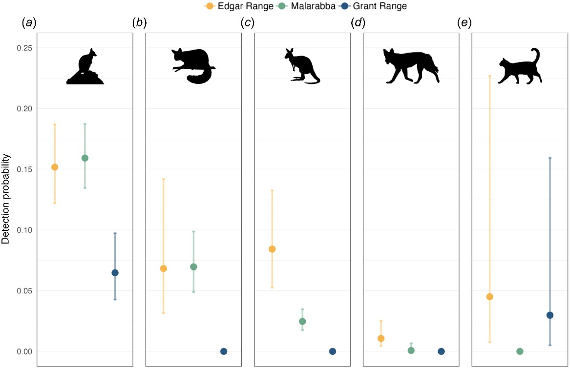
Wiliji was the most common species recorded by camera traps in surveys across the three sites (1637 detection events). At least 47 other vertebrates were recorded on camera traps during these same survey periods. The most commonly detected vertebrates after wiliji were jamandi (Osphranter robustus) (495 detection events), common rock-rat (Zyzomys argurus) (405 detection events), langurru (Trichosurus vulpecula) (257 detection events), and karnajinangany (Tachyglossus aculeatus) (210 detection events). We recorded three species identified as significant threats to rock-wallabies nationally (Lavery et al. 2021), namely, cat (Felis catus) (62 detection events), dingo (Canis familiaris) (12 detection events), and red fox (Vulpes vulpes) (three detection events). Detectability of wiliji, jamandi, langurru, feral cat, and dingo varied across the three sites (Fig. 2).
Nightly detectability of five mammal species at the Edgar Range (2016), Malarabba (2018), and Grant Range (2015): (a) wiliji (Petrogale lateralis kimberleyensis); (b) langurru (Trichosurus vulpecula); (c) jamandi (Osphranter robustus); (d) dingo (Canis familiaris); and (e) feral cat (Felis catus).
Detection probabilities
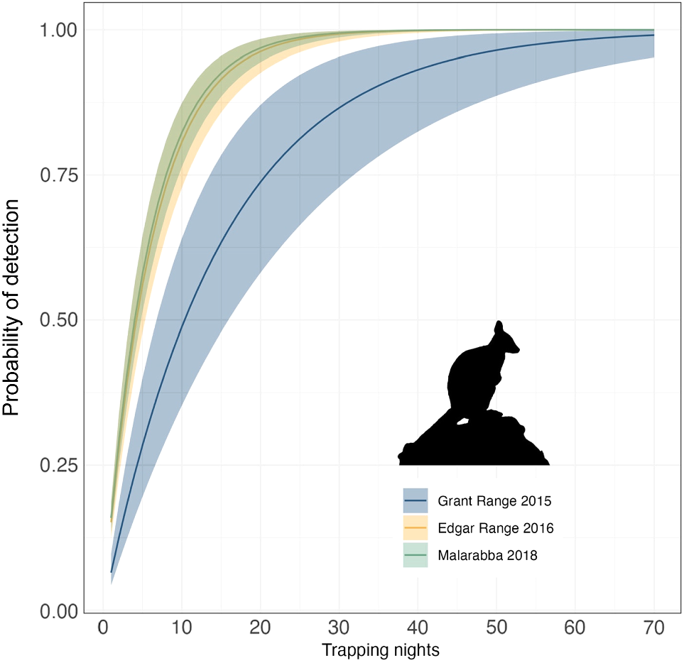
Camera-trap detection probabilities for wiliji were similar at Malarabba and the Edgar Range, but greater effort was required to detect the species at the Grant Range. The number of survey nights necessary to be 95% certain that each site was unoccupied by wiliji was 18 nights ± 95% confidence interval (CI) 3 nights (Malarabba), 19 ± CI 5 nights (Edgar Range), and 45 ± CI 15 nights (Grant Range) (Fig. 3).
Cumulative nightly detection probabilities for wiliji by using camera traps set at three sites (Grant Range, Edgar Range, and Malarabba), north-western Australia. Shading represents 95% confidence intervals.
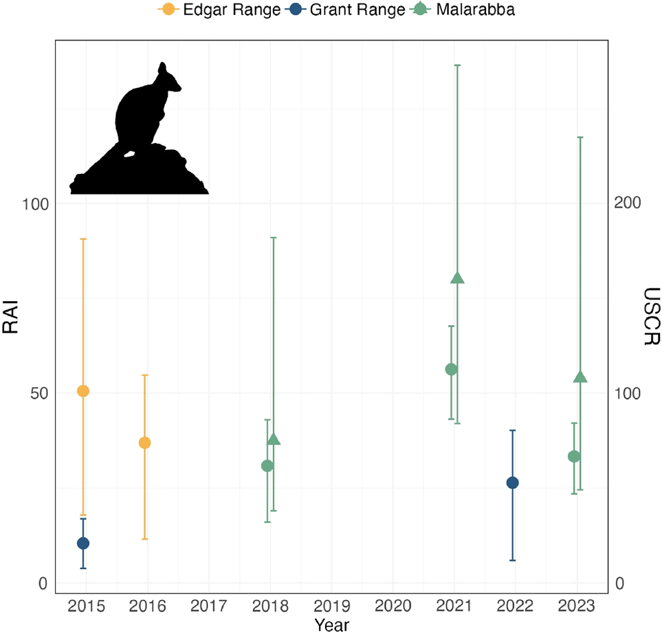
Relative abundance indices (RAIs) were lowest at Grant Range, ranging between 10.4 in 2015 and 26.4 in 2022 (Fig. 4). RAIs at Edgar Range ranged between 36.9 and 50.6 for the 2015 and 2016 surveys and variance estimates were greatest for these surveys where just 5 and 13 cameras were used respectively. At Malarabba, RAIs were lowest in 2018 (30.9), greatest in 2021 (56.3), and again lower in 2023–2024 (33.3) (Fig. 4).
Relative abundance indices (RAI) (number of detection events/100 trap nights) and abundance estimates (USCR) for wiliji recorded using camera traps at the Grant Range, Edgar Range, and Malarabba (2015–2023). Solid circles represent relative abundance values corresponding to the left axis and error bars depict bootstrapped 95% confidence intervals. Solid triangles represent unmarked spatial capture–recapture median abundance estimates corresponding to the right axis and error bars represent 2.5% and 97.5% credible limits.
Malarabba abundance estimates
Model convergence (Rhat < 1.1) indicated sufficient spatial correlation of rock-wallaby detections for application of the unmarked spatial capture–recapture method to the Malarabba data. Abundance estimates varied across the three survey periods from a median of 75 (95% credible interval (CrL) 38–182) individuals in 2018, to 160 (CrL 84–273) in 2021 and 108 (CrL 49–235) in 2023 (Table 2, Fig. 4). Estimates from USCR models corresponded with RAIs for the same surveys.
| Year | Parameter | Mode | Mean | Median | 2.5% CrL | 97.5% CrL | |
|---|---|---|---|---|---|---|---|
| 2018 | 67.80 | 83.00 | 75.00 | 38.00 | 182.00 | ||
| λ0 | 1.55 | 2.21 | 1.88 | 0.40 | 6.75 | ||
| Ψ | 0.23 | 0.28 | 0.25 | 0.12 | 0.60 | ||
| σ | 0.08 | 0.08 | 0.08 | 0.06 | 0.09 | ||
| 2021 | 148.00 | 165.00 | 160.00 | 84.00 | 273.00 | ||
| λ0 | 0.38 | 0.40 | 0.39 | 0.25 | 0.60 | ||
| Ψ | 0.54 | 0.57 | 0.55 | 0.30 | 0.92 | ||
| σ | 0.07 | 0.08 | 0.08 | 0.06 | 0.09 | ||
| 2023 | 87.00 | 117.00 | 108.00 | 49.00 | 235.00 | ||
| λ0 | 0.06 | 0.07 | 0.07 | 0.03 | 0.12 | ||
| Ψ | 0.31 | 0.39 | 0.36 | 0.16 | 0.78 | ||
| σ | 0.08 | 0.08 | 0.08 | 0.06 | 0.09 |
Data for parameters of the detection functions λ0 and Ψ, and spatial scale σ, and 95% credible intervals (CrL) are also presented.
Discussion
Directed by key questions from the Nyikina Mangala Rangers to inform their wiliji monitoring and management program, our study collated some important baseline data on wiliji and provided important insights into using camera traps for monitoring fauna on defined rocky outcrops. We evaluated survey effort required to detect wiliji at key colonies, compared detections of other important species at these sites, and evaluated the feasibility of using camera traps to estimate wiliji abundance to track progress against threat management actions. This will serve to further the ongoing monitoring of this threatened taxon with camera traps by Nyikina Mangala Rangers.
The Nyikina Mangala Rangers regard the information derived from this study as important, because it will assist them to fulfil cultural obligations to look after Country. Rocky country, in particular, has great cultural significance, with ceremonial grounds, rock art, sacred springs, rockholes and many bush foods and medicines found on this Country, including the wiliji. Wiliji is regarded as one of the biocultural indicators of the health of rocky country; i.e. according to Elders, wiliji abundance is an indicator of general ecosystem health. Looking after Country for wiliji has flow-on benefits for all rocky country. Data analysis techniques to estimate wiliji abundance from cameras is therefore very useful for assessing one of the metrics of overall wiliji population health and health of Country. These analytical techniques can support Indigenous measures where wiliji abundance is assessed by those regularly visiting rocky country. However, in areas that are not visited regularly, having cameras on Country can assist Indigenous assessments. Additionally, comparing wiliji numbers with threat management actions such as right-way fire, cattle fencing, weed control, and feral predator control, can inform evaluation of the effectiveness of these actions and help adapt management accordingly. ‘Wiliji can tell us if we’re doing a good job’ (Albert Watson, Senior Nyikina Mangala Ranger).
Survey effort
At the Edgar Range and Malarabba, the survey periods required to be 95% confident that a site is unoccupied by wiliji were 19 and 18 nights respectively. More than double the effort is needed for the same result at Grant Range (45 nights). Preliminary surveys at Grant Range found wiliji to be sparse compared with Edgar and Malarabba (Nyikina Mangala Rangers 2015). This result therefore supports previous assessments of habitat suitability across the known distribution of wiliji and provides an important guideline for survey effort needed to detect the species at each site.
The Nyikina Mangala Rangers agree with this assessment that habitat quality may influence survey effort required. Malarabba has high-quality habitat for wiliji (i.e. many rocky caves, fig trees, and shrubs) and is much smaller in size than are the Grant and Edgar ranges. This makes Malarabba easier to access and survey, resulting in more cameras being deployed across a small area. Similarly for the Edgar Range, even though it is the largest of the three rocky outcrops studied, previous surveys were strategic, and cameras were placed on small sections of the Range where habitat appeared to be of highest quality. The Grant Range is more difficult to survey because it has the highest elevation and comprises domed rocky outcrops rather than being flat-topped with caves along the edges like Malarabba and the Edgar Range. Camera surveys take substantial time, resources, and effort; therefore, results that guide investment in effort are very useful for the ranger team.
Abundance
The configurations of cameras used at Malarabba generated suitable datasets to test the application of unmarked spatial capture–recapture models (Chandler and Royle 2013) to estimate rock-wallaby abundance. Camera traps were deployed at spacings that were less than the radial lengths estimated for rock-wallaby home ranges, enabling individuals to be recorded across multiple cameras, and spatially correlated detections to be generated.
The use of unmarked spatial capture–recapture models has become more feasible for estimating abundance (Chandler and Royle 2013). However, results are generally considered less precise than those of spatial mark–recapture methods and Gilbert et al. (2021) urged their use with caution. We are aware of just one population estimate previously published for Malarabba wiliji, with which we can make comparisons, identified as a rough estimate of 100 individuals (Pearson 2013). Our abundance estimates fell either side of this mark, at approximately 75, 160, and 108 individuals. Confidence intervals around these estimates were very large, rendering it difficult to accurately detect population changes over time. Smaller confidence intervals accompanying our Malarabba estimates, and unpublished data simulations indicated that a greater survey effort may alleviate this problem. Unfortunately, alternative robust data (e.g. mark–recapture data) are unavailable to further validate our values. However, the fluctuations in our estimates (being lowest in 2018, increasing into 2021, before falling again in 2023) do correspond with events on Nyikina Mangala Country. Late dry-season wildfires affected more than 75% of Malarabba in both November 2017 and again in November 2023 (North Australia and Rangelands Fire Information 2024). This possibly influenced wiliji abundance during the 2018 and 2023/2024 post-fire surveys, because rock-wallabies may move out of an area after fire if their food resources are considerably reduced (D. Pearson, unpubl. data).
The Nyikina Mangala Rangers regard wiliji population estimates as vitally important to inform their Healthy Country adaptive management program (Walalakoo Aboriginal Corporation 2016). Evaluation against Healthy Country targets and threat management is conducted every year by rangers and their Healthy Country Committee, and monitoring occurs quarterly. It is important to identify links between environmental conditions, threatening processes, and monitoring data to support adaptive management. Feral predator hotspots identified by cameras also assist in developing management strategies. Incidences of late dry-season wildfire on Malarabba were linked with lower wiliji abundance post-fire. The rangers aim to implement right-way fire management (cf. Walalakoo Aboriginal Corporation 2016) around Malarabba, as well as the Grant and Edgar ranges, with discussions and fire planning meetings scheduled with pastoralists where wiliji occur on non-exclusive possession Native Title areas. ‘Wildfire is the most important threat to wiliji’ (Darraga John Watson, Nyikina Mangala Elder).
One disadvantage of the unmarked spatial capture–recapture method we applied in this study is that it relies on Bayesian frameworks and is computationally expensive (Royle et al. 2014; Gilbert et al. 2021). This, and the need for advanced statistical programming skills, can be barriers for use by many practitioners and organisations. Many Indigenous organisations and ranger groups are actively seeking to manage their Country using combinations of Indigenous knowledge and scientific methods (Ens 2012; Service et al. 2014). The use of camera traps has increased exponentially over the past two decades (Rovero and Zimmermann 2016). Knowledge of Country, animal signs, habitat preferences and behaviour mean that Indigenous ranger groups may be able to use camera traps more effectively, positioning them at times and locations with the greatest opportunities to detect target species (Lavery et al. 2020; Moore et al. 2020b). This can enable a shift in survey focus from presence–absence to the collection of data that allow estimates of abundance, such as those performed here. Importantly, we have demonstrated the retrofitting of unmarked spatial capture–recapture models to such camera trap survey data. This could offer extremely useful avenues to retrospectively explore the status and trajectory of populations by using camera trap data repositories held by ranger groups. Our links among an Indigenous organisation, government agencies, non-government organisations, and universities has ensured that the collective skills and resources needed to collect and analyse data are available.
Monitoring with cameras
We see some key advantages that camera traps hold over other methods for monitoring wiliji. First and foremost, collecting camera trap data is an engaging activity that Nyikina Mangala Rangers (and likely most ranger groups) prefer over other methods such as faecal pellet counts. Cameras can provide information about a particular animal of interest, but importantly also allow the opportunity to engage with Elders and the broader community to discuss animals moving through (or absent from) that area (Campbell et al. 2022; Wysong et al. 2022). Second, as we have demonstrated, camera traps simultaneously collect useful data on co-occurring species. Successful monitoring programs should invariably provide information on threats to a population, as well as the effects and implications of management actions put into place (Legge et al. 2018; Lindenmayer et al. 2020). Our data have reinforced the ability of camera traps to collect data on the risk of predation, one of the major threats to rock-wallabies (Lavery et al. 2021). Feral cat and dingo were both recorded among wiliji colonies, as was the red fox. The presence of this latter species in the study area is at the extreme edge of its current Australian distribution and prior to these surveys it had only been detected rarely in the Edgar Ranges, and has not been widely considered a threat to wiliji conservation management (Pearson 2013). A third consideration is that counts of individuals are not always good surrogates for long-term population trajectories (Belder et al. 2018, 2019). For some species, it is critical to collect broader demographic data such as reproductive success that can forecast population trends (Lindenmayer et al. 2020). The camera trap data used in this study contain such demographic data (e.g. young at foot) that could be incorporated to better understand detected population changes.
We acknowledge that few monitoring methods can provide all data necessary to adequately monitor and manage a threatened species, and that the employment of multiple methods targeting different data may be optimal here as in many other cases. Continued development of analytical methods for camera trap data and other non-intrusive ways to estimate abundance will serve to further extend this powerful combination for monitoring led by Indigenous organisations. Several actions will further strengthen the application of unmarked spatial capture–recapture models for monitoring wiliji. One is to refine the informative priors for use in the models. Taxon-specific home range estimates would enable a more informative spatial scale parameter (σ) to be included to improve the spatial correlation of detection data. Long-term studies are therefore needed to provide a comprehensive understanding of the most appropriate model parameters under changing conditions. The animal trapping program required for a home range study would coincidently allow for a mark–recapture survey to generate a robust population size estimate for comparison and set an improved upper population limit (parameter M).
The Nyikina Mangala Rangers intend to establish a permanent monitoring program for wiliji, and other culturally important animals on rocky country. Cameras are seen as a useful monitoring method to capture a holistic picture, as well as to target particular species and places of interest. To improve estimates of wiliji abundance from future camera surveys, the rangers will aim to conduct a wiliji home range study at each of the key rocky outcrops on Nyikina Mangala Country. This will inform camera placement to ensure that the distance between cameras is less than a wiliji’s home range in a particular place, because this may differ depending on habitat quality and other prevailing threatening processes. These studies, combined with genetic testing, will also assist in determining dispersal patterns and genetic health.
Recommendations for future monitoring
Recent work on threatened species monitoring in Australia has highlighted that effective programs must look beyond data collection to include explicit links to management (Legge et al. 2018; Scheele et al. 2019; Lindenmayer et al. 2020). Our case study focused on a subspecies of rock-wallaby with a distribution limited to a single Native Title Determination area, and absent from any WA governmental conservation reserve. This makes the coordination of monitoring activities a relatively straightforward task. Moreover, it is an effective means for embedding monitoring within appropriate land management regimes. For example, monitoring should not only be a passive surveillance of ongoing trends, but should be used to assess responses of these populations to putative threats (e.g. fire) and management (e.g. control efforts for feral cats). This helps continually hone and justify such management, and provide feedback to managers of the outcomes of their investments.
Our results at Malarabba and unpublished simulations have demonstrated that increased survey effort (more cameras) can reduce confidence intervals around the abundance estimates derived from unmarked models. Deploying denser arrays of cameras can thus enable monitoring data to better determine changes in wiliji populations over time. However, there are inherent trade-offs with increasing survey effort, including larger investments in equipment, and occupying the limited time of personnel. Approaches to optimise the return on monitoring investment will help determine the best survey effort. Confidence intervals can be further reduced through wiliji home-range studies to determine the best model priors.
Support for a long-term, consistent wiliji monitoring program must be secured to ensure that changes beyond normal population fluctuations can be detected (Woinarski 2018). Central to this will be maintaining continuity of the Nyikina Mangala Ranger program and retention of rock-wallaby monitoring expertise within the organisation. WWF-Australia has provided financial support to date but long-term, sustainable funding commitments are essential. An enduring partnership between Walalakoo Aboriginal Corporation, Nyikina Mangala Rangers and universities and government and non-government organisations will also be important. Ultimately, for these activities to effectively aid in the conservation of rock-wallabies, monitoring data must be collected consistently, stored in a secure location with clear responsibilities for long-term management, be maintained in a readily accessible and up to date location, and provide regular and timely feedback to inform whether changes to management operations are needed (Woinarski 2018). These data management systems also need to take Indigenous data sovereignty and cultural considerations into account (Robinson et al. 2021). Broader linkages with similar monitoring programs will be highly beneficial to exchange knowledge and continue to refine monitoring techniques and appropriate adaptive management responses for rock-wallabies across Australia.
Cross-cultural research can take many forms. Our current study’s research focus, objectives, and purpose were predetermined by Nyikina Mangala Traditional Owners responsible for development of a wiliji management plan aligned with Healthy Country priorities and aspirations described in the Walalakoo Healthy Country Plan (Walalakoo Aboriginal Corporation 2016). Walalakoo Aboriginal Corporation regards partnerships with external organisations, such as WWF-Australia and government or non-government scientists, as valuable if they perform a specific task important to Nyikina Mangala Traditional Owners, on their terms, and under their close guidance. The current study came about because of a need identified by the Nyikina Mangala Rangers, associated with Healthy Country outcomes. Scientific expertise was sought to develop innovative modelling techniques to provide wiliji abundance estimates from camera data, and hence corroborate, support and refine the monitoring and management of wiliji. This expertise was engaged by Walalakoo Aboriginal Corporation under careful data sharing agreements, retaining IP for Traditional Owners.
WWF-Australia performed an intermediary role, at the request of Traditional Owners, to seek out scientific expertise to answer specific research questions based on the self-defined management needs of the Nyikina Mangala Rangers and Traditional Owners. Having a trusted, long-term partnership with WWF-Australia assisted Walalakoo Aboriginal Corporation in navigating the difficulties of identifying and accessing the right scientists and negotiating terms. Importantly, research questions arose directly from years of collaborative on-ground work that was co-implemented by a cross-cultural team of Nyikina Mangala Rangers and WWF-Australia staff. The rangers felt supported rather than exploited, as has occurred previously when other external organisations dictated terms and did not see themselves as performing a service for Traditional Owners, but rather prioritised their own gains. Ideally, Walalakoo Aboriginal Corporation would like to retain skills internally to conduct data analyses, but the type of specialist skills required for the current study are difficult to upskill in employees in the short term. Pathways for potential Nyikina Mangala researchers are being discussed and developed, with capacity-building a core focus for ranger teams and their support staff. Therefore, partnerships to contract in external skills, as required, are seen as a viable option when protected by well-defined partnership boundaries and guided by Traditional Owner priorities.
The wiliji program was built on more than a decade of partnership between Walalakoo Aboriginal Corporation and WWF-Australia, which focused on taking a participatory ‘two-way’ learning approach and firmly upholding free, prior and informed consent principles (Austin et al. 2019; AIATSIS 2020; Cooke et al. 2022). Both Walalakoo Aboriginal Corporation and WWF-Australia allocated time and budget to building a relationship based on co-design, co-implementation, and collaborative data processing by the entire project team for all components of the program. Results were discussed and interpretated together with rangers and senior cultural advisors, enhancing cross-cultural synergies and integrating learnings into an adaptive management framework for the wiliji program. Information was, and continues to be, shared with the broader community, as well as the Walalakoo Healthy Country Committee and Board of Management. Knowledge sharing with other ranger groups, regionally and nationally, remains a purposeful objective of the program. This paper arose from such shared consultation, and the intention to publish it (to help illustrate one example of effective and appropriate collaboration), was endorsed by the board of Walalakoo Aboriginal Corporation.
There is a considerable opportunity for the environmental science and management sector to create and maintain strong and meaningful cross-cultural partnerships for the benefit of all Australians. There are many advantages associated with these partnerships, such as supporting ‘two-way’ learning and integration of knowledge systems, if the partnership is guided by Aboriginal ways of knowing, being, and doing and empowers Aboriginal self-determined exercising of rights and responsibilities to Country. However, all parties must be prepared to invest in building trust and working together to ensure power is placed firmly in the hands of Traditional Owners.
Data availability
Data are available from Walalakoo Aboriginal Corporation upon reasonable request and under data sharing agreement.
Conflicts of interest
Sarah Legge is an Editor-in-Chief of Wildlife Research. To mitigate this potential conflict of interest she had no editor-level access to this manuscript during peer review. The authors have no further conflicts of interest to declare.
Declaration of funding
We thank WWF-Australia, Lotterywest, the Foundation for Australia’s Most Endangered Species (FAME), and the Western Australian Government’s State NRM Program for financial support. The preparation of this paper was initiated under the Australian Government’s National Environmental Science Program (Threatened Species Recovery Hub).
Acknowledgements
We acknowledge the Nyikina Mangala Peoples as the Traditional Owners of the lands on which this work was conducted, and pay our respect to Elders past, present and emerging. We thank Walalakoo Aboriginal Corporation staff and Board, particularly Executive Chairperson Robert Watson, General Manager Tiffany Labuc, previous CEO Ray de Silva, previous WECS Manager Scott Herring, and previous Ranger Coordinators Damien Giles, Hamish Brace, Ben Fleay, and Kyle Raina for facilitating ranger activities including the monitoring of wiliji on Nyikina Mangala Country. Thanks go to Ellie Boyle and Hamsini Bijlani for assistance in the field. We thank two anonymous reviewers and an Associate Editor for their helpful comments on the manuscript.
References
Austin BJ, Robinson CJ, Mathews D, Oades D, Wiggin A, Dobbs RJ, Lincoln G, Garnett ST (2019) An Indigenous-led approach for regional knowledge partnerships in the Kimberley Region of Australia. Human Ecology 47, 577-588.
| Crossref | Google Scholar |
Belder DJ, Pierson JC, Ikin K, Lindenmayer DB (2018) Beyond pattern to process: current themes and future directions for the conservation of woodland birds through restoration plantings. Wildlife Research 45, 473-489.
| Crossref | Google Scholar |
Belder DJ, Pierson JC, Ikin K, Blanchard W, Westgate MJ, Crane M, Lindenmayer DB (2019) Is bigger always better? Influence of patch attributes on breeding activity of birds in box-gum grassy woodland restoration plantings. Biological Conservation 236, 134-152.
| Crossref | Google Scholar |
Buckland ST, Anderson DR, Burnham KP, Laake JL, Borchers DL, Thomas L (2001) ‘Introduction to distance sampling: estimating abundance of biological populations.’ (Oxford University Press) 10.1093/oso/9780198506492.001.0001
Campbell BL, Gallagher RV, Ens EJ (2022) Expanding the biocultural benefits of species distribution modelling with Indigenous collaborators: case study from northern Australia. Biological Conservation 274, 109656.
| Crossref | Google Scholar |
Chandler RB, Royle JA (2013) Spatially explicit models for inference about density in unmarked or partially marked populations. The Annals of Applied Statistics 7, 936-954.
| Crossref | Google Scholar |
Cooke P, Fahey M, Ens EJ, Raven M, Clarke PA, Rossetto M, Turpin G (2022) Applying biocultural research protocols in ecology: insider and outsider experiences from Australia. Ecological Management & Restoration 23, 64-74.
| Crossref | Google Scholar |
DCCEEW (2020) Petrogale lateralis kimberleyensis in Species Profile and Threats Database. Department of Climate Change, Energy, the Environment and Water. Available at http://www.environment.gov.au/sprat [accessed 22 November 2020]
de Valpine P, Turek D, Paciorek CJ, Anderson-Bergman C, Lang DT, Bodik R (2017) Programming with models: writing statistical algorithms for general model structures with NIMBLE. Journal of Computational and Graphical Statistics 26, 403-413.
| Crossref | Google Scholar |
Eldridge MDB, Potter S (2019) Taxonomy of rock-wallabies, Petrogale (Marsupialia : Macropodidae). V. A description of two new subspecies of the black-footed rock-wallaby (Petrogale lateralis). Australian Journal of Zoology 67, 19-26.
| Crossref | Google Scholar |
Ens EJ, Pert P, Clarke PA, Budden M, Clubb L, Doran B, Douras C, Gaikwad J, Gott B, Leonard S, Locke J, Packer J, Turpin G, Wason S (2015) Indigenous biocultural knowledge in ecosystem science and management: review and insight from Australia. Biological Conservation 181, 133-149.
| Crossref | Google Scholar |
Fick SE, Hijmans RJ (2017) WorldClim 2: new 1-km spatial resolution climate surfaces for global land areas. International Journal of Climatology 37, 4302-4315.
| Crossref | Google Scholar |
Fiske I, Chandler R (2011) unmarked: an R package for fitting hierarchical models of wildlife occurrence and abundance. Journal of Statistical Software 43, 1-23.
| Crossref | Google Scholar |
Forsyth DM, Ramsey DSL, Woodford LP (2019) Estimating abundances, densities, and interspecific associations in a carnivore community. The Journal of Wildlife Management 83, 1090-1102.
| Crossref | Google Scholar |
Garnett ST, Burgess ND, Fa JE, Fernández-Llamazares Á, Molnár Z, Robinson CJ, Watson JEM, Zander KK, Austin B, Brondizio ES, Collier NF, Duncan T, Ellis E, Geyle H, Jackson MV, Jonas H, Malmer P, McGowan B, Sivongxay A, Leiper I (2018) A spatial overview of the global importance of Indigenous lands for conservation. Nature Sustainability 1, 369-374.
| Crossref | Google Scholar |
Garnett ST, Butchart SHM, Baker GB, Bayraktarov E, Buchanan KL, Burbidge AA, Chauvenet ALM, Christidis L, Ehmke G, Grace M, Hoccom DG, Legge SM, Leiper I, Lindenmayer DB, Loyn RH, Maron M, McDonald P, Menkhorst P, Possingham HP, Radford J, Reside AE, Watson DM, Watson JEM, Wintle B, Woinarski JCZ, Geyle HM (2019) Metrics of progress in the understanding and management of threats to Australian birds. Conservation Biology 33, 456-468.
| Crossref | Google Scholar | PubMed |
Gelman A, Rubin DB (1992) Inference from iterative simulation using multiple sequences. Statistical Science 7, 457-472.
| Crossref | Google Scholar |
Gilbert NA, Clare JDJ, Stenglein JL, Zuckerberg B (2021) Abundance estimation of unmarked animals based on camera-trap data. Conservation Biology 35, 88-100.
| Crossref | Google Scholar | PubMed |
Iannarilli F, Arnold TW, Erb J, Fieberg JR (2019) Using lorelograms to measure and model correlation in binary data: applications to ecological studies. Methods in Ecology and Evolution 10, 2153-2162.
| Crossref | Google Scholar |
Lavery TH, Alabai M, Esau T, Fuiberi S, Furina D, Johnson RN, Kekeubata E, MacLaren D, Waneagea J, Flannery TF (2020) Integrating traditional knowledge, science and conservation in the search for undescribed mammals on Malaita, Solomon Islands. Pacific Conservation Biology 26, 404-411.
| Crossref | Google Scholar |
Lavery TH, Eldridge M, Legge S, Pearson D, Southwell D, Woinarski JCZ, Woolley L-A, Lindenmayer D (2021) Threats to Australia’s rock-wallabies (Petrogale spp.) with key directions for effective monitoring. Biodiversity and Conservation 30, 4137-4161.
| Crossref | Google Scholar |
Legge S, Rumpff L, Garnett ST, Woinarski JCZ (2023) Loss of terrestrial biodiversity in Australia: magnitude, causation, and response. Science 381, 622-631.
| Crossref | Google Scholar | PubMed |
Leiper I, Zander KK, Robinson CJ, Carwadine J, Moggridge BJ, Garnett ST (2018) Quantifying current and potential contributions of Australian indigenous peoples to threatened species management. Conservation Biology 32, 1038-1047.
| Crossref | Google Scholar | PubMed |
Lindenmayer D, Woinarski J, Legge S, Southwell D, Lavery T, Robinson N, Scheele B, Wintle B (2020) A checklist of attributes for effective monitoring of threatened species and threatened ecosystems. Journal of Environmental Management 262, 110312.
| Crossref | Google Scholar |
Moorcroft H, Ignjic E, Cowell S, Goonack J, Mangolomara S, Oobagooma J, Karadada R, Williams D, Waina N (2012) Conservation planning in a cross-cultural context: the Wunambal Gaambera Healthy Country Project in the Kimberley, Western Australia. Ecological Management & Restoration 13, 16-25.
| Crossref | Google Scholar |
Moore HA, Valentine LE, Dunlop JA, Nimmo DG (2020a) The effect of camera orientation on the detectability of wildlife: a case study from north-western Australia. Remote Sensing in Ecology and Conservation 6, 546-556.
| Crossref | Google Scholar |
Moore HA, Champney JL, Dunlop JA, Valentine LE, Nimmo DG (2020b) Spot on: using camera traps to individually monitor one of the world’s largest lizards. Wildlife Research 47, 326-337.
| Crossref | Google Scholar |
Muhic J, Abbott E, Ward MJ (2012) The warru (Petrogale lateralis MacDonnell Ranges Race) reintroduction project on the Anangu Pitjantjatjara Yankunytjatjara Lands, South Australia. Ecological Management & Restoration 13, 89-92.
| Crossref | Google Scholar |
NESP TSR Hub (2019) Threatened species strategy year 3 scorecard – Black-footed Rock-wallaby. Australian Government, Canberra, ACT, Australia. Available at http://www.environment.gov.au/biodiversity/threatened/species/20-mammals-by-2020/black-footed-rock-wallaby
North Australia and Rangelands Fire Information (2024) Latest cloud conditions. Available at https://firenorth.org.au/nafi3/ [accessed 18 March 2024]
Pearson D (1997) Aboriginal involvement in the survey and management of rock-wallabies. Australian Mammalogy 19, 1249-2566.
| Google Scholar |
Pearson D (2013) Recovery plan for five species of rock wallabies: Black-footed rock wallaby (Petrogale lateralis), Rothschild rock wallaby (Petrogale rothschildi), Short-eared rock wallaby (Petrogale brachyotis), Monjon (Petrogale burbidgei) and Nabarlek (Petrogale concinna) 2012-2022. Department of Parks and Wildlife, Perth.
Pearson DJ, Kinnear JE (1996) A review of the distribution, status and conservation of rock-wallabies in Western Australia. Australian Mammalogy 19, 137-152.
| Crossref | Google Scholar |
Plummer M, Best N, Cowles K (2006) CODA: convergence diagnosis and output analysis for MCMC. Available at https://journal.r-project.org/articles/RN-2006-002/RN-2006-002.pdf
Potter S, Close RL, Taggart DA, Cooper SJB, Eldridge MDB (2014) Taxonomy of rock-wallabies, Petrogale (Marsupialia: Macropodidae). IV. Multifaceted study of the brachyotis group identifies additional taxa. Australian Journal of Zoology 62, 401-414.
| Crossref | Google Scholar |
R Core Team (2022) R: a language and environment for statistical computing. Available at https://www.R-project.org/
Ramsey DSL, Caley PA, Robley A (2015) Estimating population density from presence–absence data using a spatially explicit model. The Journal of Wildlife Management 79, 491-499.
| Crossref | Google Scholar |
Reed G, Brunet ND, Longboat S, Natcher DC (2021) Indigenous guardians as an emerging approach to indigenous environmental governance. Conservation Biology 35, 179-189.
| Crossref | Google Scholar | PubMed |
Renwick AR, Robinson CJ, Garnett ST, Leiper I, Possingham HP, Carwardine J (2017) Mapping Indigenous land management for threatened species conservation: an Australian case-study. PLoS ONE 12, e0173876.
| Crossref | Google Scholar |
Robinson CJ, Kong T, Coates R, Watson I, Stokes C, Pert P, McConnell A, Chen C (2021) Caring for Indigenous data to evaluate the benefits of indigenous environmental programs. Environmental Management 68, 160-169.
| Crossref | Google Scholar | PubMed |
Ruykys L, Ward MJ, Taggart DA, Breed WG (2011) Preliminary spatial behaviour of warru (Petrogale lateralis MacDonnell Ranges race) in the Anangu Pitjantjatjara Yankunytjatjara Lands, South Australia. Australian Mammalogy 33, 181-188.
| Crossref | Google Scholar |
Scheele BC, legge S, Blanchard W, Garnett S, Geyle H, Gillespie G, Harrison P, Lindenmayer D, Lintermans M, Robinson N, Woinarski J (2019) Continental-scale assessment reveals inadequate monitoring for threatened vertebrates in a megadiverse country. Biological Conservation 235, 273-278.
| Crossref | Google Scholar |
Schuster R, Germain RR, Bennett JR, Reo NJ, Arcese P (2019) Vertebrate biodiversity on indigenous-managed lands in Australia, Brazil, and Canada equals that in protected areas. Environmental Science & Policy 101, 1-6.
| Crossref | Google Scholar |
Service CN, Adams MS, Artelle KA, Paquet P, Grant LV, Darimont CT (2014) Indigenous knowledge and science unite to reveal spatial and temporal dimensions of distributional shift in wildlife of conservation concern. PLoS ONE 9, e101595.
| Crossref | Google Scholar |
Sollmann R, Mohamed A, Samejima H, Wilting A (2013) Risky business or simple solution – relative abundance indices from camera-trapping. Biological Conservation 159, 405-412.
| Crossref | Google Scholar |
Telfer WR, Garde MJ (2006) Indigenous knowledge of rock kangaroo ecology in Western Arnhem Land, Australia. Human Ecology 34, 379-406.
| Crossref | Google Scholar |
Telfer WR, Griffiths AD (2006) Dry-season use of space, habitats and shelters by the short-eared rock-wallaby (Petrogale brachyotis) in the monsoon tropics. Wildlife Research 33, 207-214.
| Crossref | Google Scholar |
Threatened Species Scientific Committee (2021) Conservation advice Petrogale lateralis kimberleyensis. Department of Agriculture, Water and the Environment, Canberra, ACT, Australia. Available at http://www.environment.gov.au/biodiversity/threatened/species/pubs/90832-conservation-advice-24062021.pdf
Tol P (2021) Colour Schemes. Technical note SRON/EPS/TN/09-002 3.2. SRON. Available at https://cran.r-project.org/web/packages/khroma/vignettes/tol.html
Turpin JM, White NE, Dunlop JA, Bamford MJ (2018) New populations of the black-flanked rock-wallaby (Petrogale lateralis) from the Little Sandy Desert and Murchison, Western Australia. Australian Mammalogy 40, 234-242.
| Crossref | Google Scholar |
Twining JP, McFarlane C, O’Meara D, O’Reilly C, Reyne M, Montgomery WI, Helyar S, Tosh DG, Augustine BC (2022) A comparison of density estimation methods for monitoring marked and unmarked animal populations. Ecosphere 13, e4165.
| Crossref | Google Scholar |
Ward Fear G, Rangers B, Pearson D, Bruton M, Shine R (2019) Sharper eyes see shyer lizards: collaboration with indigenous peoples can alter the outcomes of conservation research. Conservation Letters 12, e12643.
| Crossref | Google Scholar |
Wickham H, Chang W, Henry L, Pedersen TL, Takahashi K, Wilke C, Woo K, Yutani H, Dunnington D, Brand Tvd, Posit PBC (2024) ggplot2: create elegant data visualisations using the grammar of graphics. Available at https://cran.r-project.org/web/packages/ggplot2/index.html [accessed 12 April 2024]
Woinarski JCZ (2018) A framework for evaluating the adequacy of monitoring programs for threatened species. In ‘Monitoring threatened species and ecological communities’. (Eds S Legge, N Robinson, D Lindenmayer, B Scheele, D Southwell, B Wintle) pp. 13–20. (CSIRO Publishing: Melbourne, Vic, Australia)
Wysong ML, Gregory P, Watson AWT, Woolley L-A, Parker CW, Yawuru Country Managers, Karajarri Rangers, Nyikina Mangala Rangers (2022) Cross-cultural collaboration leads to greater understanding of the rare Spectacled Hare-wallaby in the west Kimberley, Western Australia. Ecological Management & Restoration 23, 139-149.
| Crossref | Google Scholar |
Ziembicki MR, Woinarski JCZ, Mackey B (2013) Evaluating the status of species using Indigenous knowledge: novel evidence for major native mammal declines in northern Australia. Biological Conservation 157, 78-92.
| Crossref | Google Scholar |
Zurba M, Beazley K, English E, Buchmann-Duck J (2019) Indigenous protected and conserved areas (IPCAs), Aichi target 11 and Canada’s pathway to target 1: focusing conservation on reconciliation. Land 8, 10.
| Crossref | Google Scholar |