

Planning for whole-farm systems research at a credible scale: subdividing land into farmlets with equivalent initial conditions
J. M. Scott A H , M. Munro B , N. Rollings B C , W. Browne D , P. J. Vickery E , C. Macgregor A , G. E. Donald F and H. Sutherland GA School of Environmental and Rural Science, University of New England, Armidale, NSW 2351, Australia.
B Formerly, School of Environmental and Rural Science, University of New England, Armidale, NSW 2351, Australia.
C 25 Caringa Street, Urangan, Qld 4655, Australia.
D 22 Trim Street, Armidale, NSW 2350, Australia.
E 12 Caroline Crescent, Armidale, NSW 2350, Australia.
F Precision Agriculture Research Group, University of New England, Armidale, NSW 2351, Australia.
G ‘Deeargee’, Uralla, NSW 2358, Australia.
H Corresponding author. Email: dr.jimscott@gmail.com
Animal Production Science 53(8) 618-627 https://doi.org/10.1071/AN11176
Submitted: 14 August 2011 Accepted: 27 March 2012 Published: 10 July 2013
Journal Compilation © CSIRO Publishing 2013 Open Access CC BY-NC-ND
Abstract
Most research comparing different farming systems has been conducted on relatively uniform plots at small scales made necessary by the desire for sufficient replication of the systems and cost limitations. This paper describes an alternative approach to plan the allocation of land to three unreplicated whole-farm management systems such that each farmlet had equivalent starting conditions and yet was at a scale credible to both livestock producers and researchers. The paddocks of each farmlet were distributed across the landscape in a ‘patchwork quilt’ pattern after six iterations of a mapping exercise using a Geographic Information System. Allocation of paddocks took into account those variables of the landscape and natural resource capacity that were not able to be altered. An important benefit of the procedure was that it ensured that the farmlets were co-located with contiguous paddock boundaries so that all farmlets experienced the same climatic as well as biophysical conditions. An electromagnetic survey was conducted of the entire property and used in conjunction with a detailed soils map in order to classify areas into soil conductivity groupings. Equivalent areas of each soil type were allocated across the three farmlets. Similarly, land was distributed according to its topography so that no farmlet would be compromised by being allocated more low lying, flood-prone land than any other farmlet. The third factor used to allocate land to each farmlet was the prior fertiliser history of the original paddocks. This process ensured that each farmlet was objectively allocated equivalent areas of soil type, topography and fertiliser history thus avoiding initial bias among the farmlets. After the plan for all paddocks of each farmlet was finalised, new paddock boundaries were drawn and where necessary, fencing was removed, modified and added, along with re-arranged watering points. The farmlet treatments commenced in July 2000 when the first pasture establishment and differential fertiliser applications were carried out. Evidence from the electromagnetic survey and the Landsat imagery confirmed that the distribution of hydrologic soil conductivity and vegetation greenness were similar between all farmlets just before the commencement of the experiment.
Introduction
The ‘Cicerone Project’ was a collaborative project between livestock producers, extension specialists, researchers and consultants on the Northern Tablelands of New South Wales, Australia. The project aimed to improve the viability of grazing enterprises through the active participation of producers in relevant research and learning.
The major researchable questions chosen, following a survey of producers (Kaine et al. 2013), were first how to maintain productive and persistent pastures, especially through dry seasons and, second, the role of grazing management in maintaining pastures and controlling internal parasites of sheep. After considerable consultation with all participants, a decision was taken to investigate these farming system issues by studying farmlets at a scale which would be seen as credible, especially by producer members of the Cicerone Project. This desire for credibility of the scale of farming systems investigations was supported by producer members and was consistent with the recommendation from a large, integrated pasture sustainability research program that more investigation of livestock systems was needed at the ‘commercial’ scale (Kemp et al. 2000).
The few farmlet experiments that have been published, described briefly below, provide few details of how farmlets were set up and no information on how best to allocate paddock areas to farmlets to avoid bias. Three unreplicated model farms of 20 ha, supporting as few as 30 sheep per farm, on a research station in Syria, were used by researchers to investigate closer crop-livestock integration over a period of 6 years (Thomson and Bahhady 1995). Small, self-contained, 1-ha farmlets were employed on two different soil types in south-west England to study the nitrogen dynamics of grazed and cut pastures for beef cattle production over 5 years (Laws et al. 2000).
Other examples of mostly small farmlets used in research, especially in the dairy industry, have been reported for: a replicated experiment exploring dairy cow stocking rates over two grazing seasons in North America (Fales et al. 1995); investigations of nitrogen cycling on four unreplicated, self-contained farmlets of 6.5 ha with each containing 16 randomly allocated paddocks in New Zealand (Ledgard et al. 1999); a study of automated milking on a 9.2-ha farmlet for which paddock layout details have been provided (Jago et al. 2007); unreplicated systems studies in Queensland dairy research where five different 20-cow systems were run under research station conditions (Lowe 2007); two 6-ha farmlets studying the effects of hay or silage conservation on the Ellinbank research farm in Victoria (Thomas and Mathews 1991); and dryland and irrigated farmlets at the Flaxley Agriculture Centre in South Australia where the areas of each were ~30 and 16 ha each, respectively, at a wide range of stocking rates (Valentine et al. 2009).
A somewhat larger farmlet study of both sheep and cattle grazing management and response to fertiliser was conducted on 99 ha of steep, moist hill country on the North Island of New Zealand (Lambert et al. 1983). This study included 10 mostly unreplicated farmlets of 7–14 ha, each of which were allocated land with similar topographical properties, due to the large impact that position in the landscape can have in this steep grassland region.
When investigations of environmental indicators of experimental dairy farms were carried out at a small scale on the ‘De Marke’ farms in the Netherlands, the authors acknowledged that, ideally, such studies should be carried out using integrated evaluations at a scale that sufficiently reflects the spatial variability of typical farms (Langeveld et al. 2007). This was the aim for the Cicerone farmlet experiment, which was located on 159 ha of land typical of the Northern Tablelands region, including the two dominant soil types, podsolic and basaltic (Schafer 1980), found in the region.
One unpublished report (Grainger 1998) described how three 9.7-ha dairy farmlets were created on equivalent areas of land in Victoria, Australia through a process of subdivision and random allocation to each farmlet. Building on this approach, a decision was taken to use an empirical method to allocate land to farmlets so that there would be as few systematic differences between those farmlets as was feasible and yet still be practical to implement.
Being an unreplicated farmlet trial, the equivalence of the starting conditions of all factors important to the productivity and sustainability of grazing enterprises on all three farmlets was a basic assumption if comparisons of the effects of management on each farmlet’s performance were to be valid (Murison and Scott 2013). This was especially true of factors which could not be changed, such as elevation, slope and soil type.
Apart from minimising differences in natural resource allocations between farmlets, some additional considerations taken into account in the planning process were to limit unnecessary fragmentation of the different farmlets thus minimising the infrastructure costs of the project and to facilitate stock movement between paddocks within farmlets and to and from the common stock yards.
The aim of this paper is to describe how the study site was surveyed and subsequently partitioned into farmlets and paddocks in such a way that each farmlet would commence with an equal allocation of natural resources which, if not equal, might otherwise have resulted in bias during the conduct of the farming systems experiment. Details of the process of optimising paddock design and allocation of land to each of the farmlets are provided together with evidence of the equivalence of the three farmlets.
Methods
The farmlet management treatments were decided upon through a process of negotiation with producer members and other interested parties over several meetings (Scott et al. 2013). The three systems chosen for comparison consisted of a typical, low cost farm management system, comprising long grazing periods and moderate soil fertility (Farmlet B), compared with a second system based on high levels of soil fertility and sown pastures (Farmlet A) and a third system focussed on intensive rotational grazing (Farmlet C).
As the control treatment, Farmlet B aimed to represent a typical grazing enterprise with a target stocking rate of 7.5 dry sheep equivalents (Turner and Alcock 2000) (DSE)/ha. In common with regional practice, there was to be a low rate of pasture renovation. The farmlet was subdivided into eight paddocks, which was considered to be the minimum number of paddocks on any operational farm and also a number which would make it difficult to allow long rest periods between grazing periods.
The target soil fertility levels chosen for the typical farmlet (B) were 20 mg/kg phosphorus (bicarbonate extract) and 6.5 mg/kg sulfur; these levels were judged, based on advice from a soil fertility expert (G. Blair, pers. comm.), as sufficient to support reasonable levels of pasture production and were somewhat above levels found on many farms in the region [details of the soil fertility aspects of the farmlet experiment have been reported in a paper in this Special Issue by Guppy et al. (2013)]. This farmlet was designed to employ flexible grazing management according to PROGRAZE principles (Bell and Allan 2000). In brief, these principles included moving stock to the next best paddock within each farmlet, in terms of digestible green herbage, when minimum critical levels of green herbage mass and herbage digestibility were reached. These varied for different classes of livestock, while also taking into account the physiological status of the animals grazing a particular pasture as well as the growth rate of that pasture. More details of the movement of stock and of stocking rates have been provided in related papers on the farmlet experimental guidelines (Scott et al. 2013) and on livestock performance (Hinch et al. 2013).
Farmlet A had the same number of paddocks and grazing management approach as Farmlet B, but was focussed on high inputs with a target of 100% of paddocks dominated by sown species and soil fertility levels of 60 mg/kg phosphorus and 10 mg/kg sulfur and a target stocking rate of 15 DSE/ha. Farmlet C had the same target soil nutrient levels as Farmlet B but focussed on intensive rotational grazing management with short graze, and long rest, periods. Initially Farmlet C had 17 paddocks; subsequently these paddocks were further subdivided making 37 paddocks using electric fences to allow for longer periods of rest from grazing to be implemented. It aimed at the same target stocking rate as Farmlet A (15 DSE/ha).
The study site was wholly contained within the CSIRO property ‘Chiswick’, located 17 km south of Armidale, New South Wales (latitude 30°37′S, longitude 151°33′E, at an altitude of ~1050 m a.s.l.). This property has been used by CSIRO for over 50 years for a wide range of scientific experiments with grazing animals (mainly sheep), animal health, pasture species, soil fertility, remote sensing, sustainability and many others (Hutchinson 1997). Thus, the site was well known not only to collaborating scientists but, importantly, to the livestock producers of the Northern Tablelands of New South Wales and hence was chosen for these farming systems studies.
The total area of land leased from CSIRO by the Cicerone Project was ~200 ha with 159 of that being allocated to the three farmlets; the remainder was used for maintenance of some animals with a suitable quarantine status (e.g. for Ovine Johne’s disease), in case any of the farmlets needed to purchase additional animals. This area on the periphery was also used for 6 weeks each autumn to allow joining of all farmlet ewes to common rams to avoid genetic differences between farmlets resulting from different sires.
The property, which generally has little topographic relief, slopes gently from the south towards an extensive, lower flat area in the north where some ephemeral flooding occasionally occurs. Fertiliser (superphosphate) had been applied differentially, at least since 1977, to three separate zones of the target area.
The pastures of this research farm were typically dominated by either warm season native grasses and/or sown perennial grasses with a minor component of sown legumes and have had a long history of investigation stretching back to the 1940s (Roe 1947; Begg 1959). In general, the area had been grazed at a low intensity over several years before the commencement of this farmlet study, resulting in dense pasture cover of mostly native and sown perennial grasses. Some of the areas had substantial proportions of sown perennial species (e.g. Phalaris aquatica), which had been established at least 10 years before the commencement of these farmlet trials.
The characteristics of the land that were unable to be changed (hydrology, soil type and slope) were used as the primary means of allocating land to the farmlets. The recent fertiliser application history, while important, was given a lower priority as soil fertility could be more readily altered by withholding or applying fertiliser whereas the other characteristics of the land could not be changed.
The process of allocating areas of land of equivalent capacity to each farmlet was conducted in the stepwise process detailed below.
Planning process
All digital map production involved the use of ArcInfo/ArcView (Environmental Systems Research Institute Inc., Sydney, NSW, Australia) during both the digitising and processing stages unless otherwise specified. Data obtained from ArcInfo/ArcView were transferred to the open-source software R (R Development Core Team 2009) for statistical analysis.
Digitising physical infrastructure
A detailed property map was used to hand-digitise the boundary, fence positions, locations of water troughs and existing roads. Map-derived fence lengths were checked against fence measurements taken using a differential GPS device and found to be consistent.
Electromagnetic survey and soil hydrology
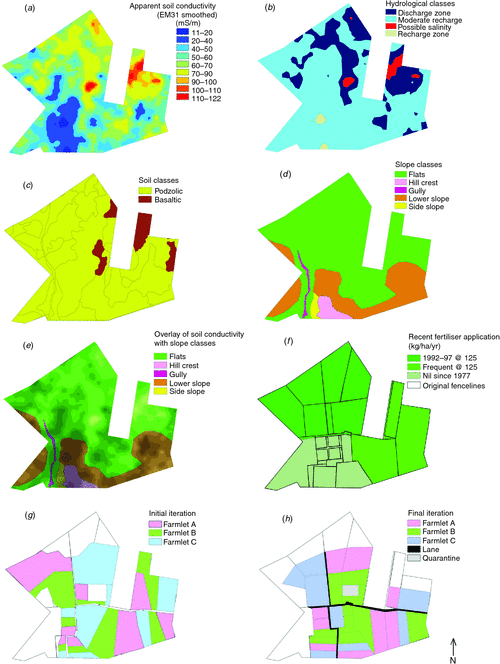
To detect the variation in apparent electrical conductivity, which is known to be related to soil drainage characteristics of the upper soil profile, an electromagnetic survey of all of the candidate land area was conducted using an EM31 instrument linked to a differential GPS on a 4-wheel motor bike (Beecher et al. 2002). The GPS system captured 5547 data values ranging between 3 and 147 mS/m across the entire candidate area using transect spacings of ~40 m with measurement intervals along each transect of ~10 m. Once these point values were entered into the ArcInfo/ArcView program, they were interpolated using the inverse distance algorithm in ArcInfo GRID to produce a continuous two-dimensional surface. A smoothing convolution filter (5 by 5) was then applied across the entire image to remove extreme values. The smoothed image was then reclassified into four zones showing the degree of recharge/discharge characteristics; values less than 20 mS/m were assigned to recharge zones, between 20 and 70 mS/m to a moderate recharge zone, between 70 and 100 mS/m to a discharge zone and greater than 100 mS/m to a discharge zone with possible salinity (S. Murray, pers. comm.). Finally, the hydrological map was converted from a raster (grid) into a vector (object-based) thematic map for area comparisons and display purposes.
Mapping of soil types
A soils map of the target land area (Schafer 1980) based on traditional soil survey methods using relatively sparse soil cores was digitised in ArcInfo to the Australian Map Grid (AMG 84). The 14 soil groups identified were considered too complex in number and distribution for the purpose of allocating equivalent areas of similar soil types to the farmlets so they were simplified into two primary soil type groups – basaltic and podsolic (Schafer 1980).
The generalised map of these two soil types was then compared with the four hydraulic conductivity zones (indicating relative recharge/discharge zones) derived from the electromagnetic inductance (EM) data. The EM data zones appeared to be well correlated with the areas of basaltic (higher EM values) and podsolic (lower EM values) soil types; this conclusion was endorsed by an experienced researcher who had studied landscape issues on this land (coauthor, P. J. Vickery). Thus, in view of the large number of objective sampling points incorporated within the EM data compared with the relatively sparse data based on soil cores which contributed to the traditional soils map, the soil hydrology zone map based on the EM data was used to quantify the spatial distribution of soil physical characteristics (primarily soil conductivity which reflects a soil’s capacity to hold and/or drain water).
Mapping of slope
The elevation measurements captured with the differential GPS on the 4-wheel motor bike were too coarse to construct a digital elevation map with sufficiently fine resolution for mapping of slope. Thus, an aerial photograph was used by one of the authors, an experienced land planner (W. Browne), to draw approximate contours delineating the candidate land area into four main slope classes: hill tops, lower slopes, flats, and a steeper gully side slope, as well as to exclude the small gully area from any of the farmlets. These slope classes were digitised into ArcInfo to produce a Shapefile depicting slope classes.
Zones of fertiliser use
Records of recent fertiliser use on the candidate land area (D. Wilkinson, pers. comm.) were used to create a map showing three areas differing in the amounts of superphosphate which had been applied aerially over recent decades:
-
Nil: had received no fertiliser since 1977;
-
Recent: had received superphosphate at ~125 kg/ha.year between 1992 and 1997 and
-
Regular: had received superphosphate at ~125 kg/ha.year in most years between 1977 and 1997. These mapped fertiliser areas were digitised into an ArcInfo vector file.
Iterative optimisation of distribution of land areas to three farmlets
The vector slope map was displayed showing individual slope classes as unique colours. The raster EM map was then used as an intensity control within each of these colours to shade areas of low EM and brighten those areas with high EM values.
This shaded overlay map was broken into several obvious EM/slope associations. Each of these zones was then broken into three equal areas and allocated to the three farmlets (Iteration 1). Data from each area were extracted and tabulated to compare the levels of EM, slope, soil type and recent fertiliser history for each farmlet (Initial data in Table 1).

|
Infrastructure layers (roads, fences, water troughs) were added as a guide for further iterations. Several iterations with different parts of areas allocated to farmlets were carried out in an attempt to simplify management objectives such as minimising the requirement for re-fencing and yet producing an even distribution of the most important productivity parameters across all farmlets. Laneways were also mapped to help plan for efficient stock movement, especially to and from the centralised yards and to provide easy access for those needing regular access to each farmlet. Compromises were made between the EM/slope distribution and fertiliser history, fencing costs, degree of farmlet fragmentation and management difficulty. At each iteration, the areas allocated to each of the farmlets under each classification category were compared against the values determined using the initial distribution.
These further iterations produced progressive improvements in management and financial constraints while achieving a parameter distribution superior to that of iteration 1 (initial iteration). Thus, after 6 iterations, this process eventually led to the final allocation of land to each farmlet (final iteration in Table 1). Table 1 also shows that the average CV among farmlets was improved from 23% for the initial iteration to 16% for the final iteration with marked reductions in CV especially for the soil type and fertiliser history parameters.
Treatment allocation and paddock subdivision
Ideally, the three farmlets would have been randomly allocated to the three allocated areas of land. However, as one farmlet area of the three candidate areas had a large number of inter-connected paddocks and the best access to the central laneway, it was decided, for pragmatic livestock management reasons, that this area was best suited to the intensive rotational grazing treatment (Farmlet C), which would require much more frequent movement of livestock than the other farmlets. The remaining two farmlet areas were then allocated randomly to Farmlets A and B using a toss of the coin to avoid bias in their allocation.
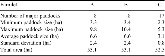
Consideration of access to laneways for each paddock and retaining as many fences as was feasible governed the partitioning of the farmlet area into their respective sizes and numbers of paddocks: eight paddocks for each of Farmlets A and B and 17 major paddocks for Farmlet C. Minor laneways were added where required. Paddock sizes were then calculated and tabled (Table 2).
|
Assessment of equivalence between farmlets
A post hoc statistical analysis of the a priori measurements of land capability characteristics was conducted to examine the equivalence of the land allocated to each farmlet. Further post hoc analyses were conducted after the trial ended using both a Digital Terrain Model (DTM) and satellite imagery. The DTM was used to extract accurate elevation and slope data which have been presented as boxplots to show the range of values as well as the inter-quartile range and median values.
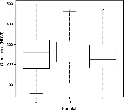
A Landsat satellite image, captured in June 2000, just before commencement of the farmlet treatments, was used to calculate a normalised difference vegetation index (NDVI), which has been the index most widely used to monitor vegetation on agricultural land (Tucker and Sellers 1986). The NDVI is calculated from the red and near-infrared (NIR) reflectance sensor bands as follows: NDVI = (NIR – Red)/(NIR + Red). NDVI was used as a surrogate measure to assess the relative differences in vegetation greenness between farmlets on 2525 pixels, each of 0.0625 ha, across all three farmlets. These data were compared using boxplots and contrasts.
Results
The areas of land allocated to each farmlet differed substantially in the initial iteration (60.3, 54.9 and 64.4 ha for Farmlets A, B and C, respectively), whereas after the final iteration, the total areas of land allocated to Farmlets A, B and C were very even being 53.1, 53.1 and 52.5 ha, respectively (Table 2). Laneways occupied an additional 7 ha of the property, while a paddock for quarantining sick animals was allocated 3.3 ha. This latter paddock was not allocated to any of the farmlets due to its unique soil physical properties. This paddock could be accessed via the laneway system and a paddock from within each farmlet system and was located in close proximity to the centralised handling yards. The outer ‘periphery’ paddocks had a combined area of ~41 ha.
Electromagnetic induction and hydrology
The smoothed electromagnetic inductance (EM31) map is presented in Fig. 1a. Raw data values ranged between 3 and 147 mS/m. High values can be seen as red areas, while low values are dark blue. The hydrology of the study area (Fig. 1b) comprised a small recharge zone, large discharge zone and some small areas possibly affected by salinity. In the final iteration, the distribution of hydrologic classes across each farmlet was close to equal with the exception of a higher proportion of Farmlet A being categorised with ‘discharge’ hydrology compared with Farmlets B or C.
|
Soil type
The primary soil data source available was the soils map based on traditional soil survey methodology (Schafer 1980). The 14 soil types identified on this map were generalised into two major soil classes: podsolic and basaltic (Fig. 1c).
Slope
Figure 1d illustrates the main terrain classifications within the property. There is a small hill to the south with a side slope on the west side leading into a gully. A moderate lower slope surrounds the northern and eastern faces of the hill undulating towards the flatter areas found on the northern part of the study area. The distribution of the slope classes across each of the farmlets was even and reasonably uniform when the initial and final iterations are compared (Table 1).
EM/slope relationship
Figure 1e displays the EM/slope relationship on the study site which was used to guide the selection of candidate subdivisions over a series of iterations.
Fertiliser history
The areas with different fertiliser distribution shown in Fig. 1f comprise three fertiliser zones. The distributions for the initial and final iterations are shown in Table 1. By the final iteration, the distribution of areas with different fertiliser histories was approximately equal.
The final iteration
No further improvements in fragmentation, fencing requirements or paddock size uniformity could be achieved without significant degradation of the EM and slope distribution over each farmlet and hence the 6th iteration was chosen as the final iteration (Fig. 1h).
Final paddock allocation
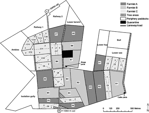
The final subdivision of the paddocks within each farmlet is presented in Fig. 2 while the distribution of major paddock sizes for each farmlet is presented in Table 2. Early in the project, a decision was taken to further subdivide the 17 major paddocks of Farmlet C into 37 subpaddocks to allow longer grazing rest periods to be implemented on this farmlet and these are shown in detail in Fig. 2.
|
The initial iteration required the removal of almost all existing fence lines and would have been expensive to re-fence due to the jagged and erratic nature of the paddock shapes. Efforts were made to ensure that fencing costs were minimised by reducing fencing requirements over successive iterations. The final iteration was able to retain most major existing fence lines, but required the removal of the smaller paddock fences on the southern hilltop. The small paddock fences removed contained many gates, fence and strainer posts that were re-used elsewhere, thus further lowering fencing costs through material recycling.
Equivalence of farmlets
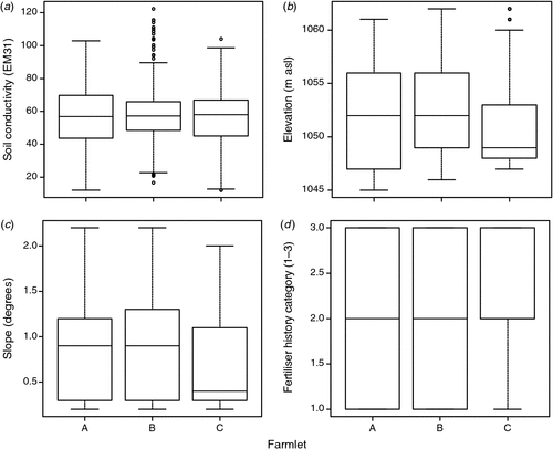
Table 1 provide empirical evidence that the farmlets were allocated areas with equivalent distributions of factors affecting productivity. The average percentage of each farmlet area allocated to each of the classification categories (Table 1) shows that there were few differences between farmlets in hydrology, soil type, slope or fertiliser history at either the initial or the final iteration. Figure 3 shows the distribution of soil conductivity (EM31) measurements (Fig. 3a), which were found not to be significantly different between farmlets (P > 0.05). Similarly, there were no significant differences in elevation (Fig. 3b), slope (Fig. 3c) or fertiliser history category (Fig. 3d).
|
Figure 4 shows a boxplot of greenness (NDVI) from the Landsat satellite image of the farmlet areas in June 2000 – just before the commencement of treatments in July 2000 – which shows a similar range across all farmlets (Donald et al. 2013). Nevertheless, it is noteworthy that Farmlet C commenced with significantly (P < 0.05) lower levels of greenness than the other two farmlets, which were not significantly different (P > 0.05) from each other.
|
Discussion and conclusions
The EM survey provided the primary means of objectively allocating land to the three farmlets. Although this method of data capture can encounter difficulties with landforms such as gullies, due to difficulties in traversing with a 4-wheel motor bike, it was able to produce good quality two-dimensional maps which correlated well with soil type. According to Williams et al. (2006), such surveys permit the various degrees of soil hydrological recharge and discharge to be mapped across a property and thus allow for land management planning in a rational way. In the case of cropping systems, it has been recognised by Dalgliesh et al. (2009) that technologies such as EM are now facilitating the movement towards ‘precision agriculture’ by allowing farmers to identify soil zones with different productive capacities.
The soil map data were not directly used in the iterative process; rather, as outlined previously, the EM data were used as a surrogate for soil type as they were found to be correlated with the two broad soil classes at the site identified in the soil map (podsolic and basaltic). Spatial soil information has been recommended for guiding the choice of representative plots by Schnug et al. (1998). Also, digital soil mapping can reduce the potential for bias which can arise with traditional soil survey methods (Carré et al. 2007).
As a consequence of the ‘patchwork’ nature of the allocation of paddock areas to farmlets, there was unavoidable fragmentation of some areas within farmlets. Although minimised through successive iterations, some fragmentation was necessary in order to allow the inclusion of laneways to facilitate livestock movement. Nevertheless, most importantly, the equivalence of the various attributes among farmlets provided the evidence that each farmlet possessed the same natural resource capacity before commencement of the different farmlet management treatments.
The distribution of paddock sizes within the farmlets was initially a cause for some concern. Ideally all paddocks within a farmlet might have been of equal size (i.e. eight paddocks of ~6.25 ha for Farmlets A and B and 17 major paddocks of ~3.09 ha for Farmlet C). However, this was difficult to achieve due to the small amount of suitable available land, the existing initial internal fencing pattern, the distribution of important parameters, the overall shape of the property and financial constraints. In spite of these constraints, as shown in Table 2, the final plan resulted in similar paddock size parameters (minimum, maximum, average and standard deviation) for both Farmlets A and B; Farmlet C parameters differed due to the need for more small paddocks in order to impose intensive rotational grazing. Although there was considerable variation between the largest and smallest paddock sizes, especially for Farmlets A and B, this was considered acceptable as this is typical of real grazing properties where paddock sizes commonly vary greatly thus imposing management challenges on the farmlets similar to those on real farms. Thus, it was recognised at the time of planning, that the choice of stocking density and grazing period would have to be monitored closely throughout the trial to avoid over- or undergrazing.
The spatial coverage of the remotely sensed data, combined with the multi-spectral attributes of Landsat to produce NDVI data, have helped to provide an objective overview which supports the validity of this non-traditional approach to exploring system differences at a field scale. More details of the differences between farmlets in satellite imagery over time have been provided by Donald et al. (2013).
The fact that the EM mapping showed that there was no difference between farmlets in soil hydrology, and that the satellite imagery showed little difference in greenness, confirmed that the land was allocated to each farmlet without bias. It is noteworthy that the satellite imagery was not available to the authors before the commencement of the trial. This lack of bias is an essential foundation for the comparison of the three farmlet systems (Murison and Scott 2013), reported by other authors in related papers in this Special Issue, which were found to diverge over time, in response to the farmlet treatments, as measured by a range of soil, pasture, livestock and economic characteristics.
Bywater (1990) noted that the science of whole-farm experimentation is a ‘woefully undeveloped’ area where many systems trials have failed to apply sufficient rigour to the understanding of systems behaviour. The need in farmlet experiments for the allocation of treatments to avoid the influence of non-experimental variables has been stressed by Clark (2010). The empirical approach taken in the planning of these unreplicated farmlets, before the imposition of different management treatments has, according to the objective evidence presented, moved beyond more ad hoc approaches to help ensure that any system differences observed were due to management treatments rather than differences in initial conditions.
Acknowledgements
The assistance of Dr Simon Murray with the interpretation of the EM data, of Mr George Truman of the Department of Infrastructure Planning and Natural Resources for providing the EM data, and of Mr Les Gallagher, Ms Caroline Gaden and Mr Justin Hoad of the Cicerone Project are gratefully acknowledged. Funding for the Cicerone Project was provided by Australian wool growers and taxpayers through Australian Wool Innovation with significant in-kind contributions from CSIRO Livestock Industries and financial and in-kind support from the University of New England.
References
Beecher HG, Hume IH, Dunn BW (2002) Improved method for assessing rice soil suitability to restrict recharge. Australian Journal of Experimental Agriculture 42, 297–307.| Improved method for assessing rice soil suitability to restrict recharge.Crossref | GoogleScholarGoogle Scholar |
Begg JE (1959) Annual pattern of soil moisture stress under sown and native pastures. Australian Journal of Agricultural Research 10, 518–529.
| Annual pattern of soil moisture stress under sown and native pastures.Crossref | GoogleScholarGoogle Scholar |
Bell AK, Allan CJ (2000) PROGRAZE – an extension package in grazing and pasture management. Australian Journal of Experimental Agriculture 40, 325–330.
| PROGRAZE – an extension package in grazing and pasture management.Crossref | GoogleScholarGoogle Scholar |
Bywater AC (1990) Exploitation of the systems approach in technical design of agricultural enterprises. In ‘Systems theory applied to agriculture and the food chain’. (Eds J Jones, P Street) pp. 61–88. (Elsevier Applied Science: London)
Carré F, McBratney AB, Minasny B (2007) Estimation and potential improvement of the quality of legacy soil samples for digital soil mapping. Geoderma 141, 1–14.
| Estimation and potential improvement of the quality of legacy soil samples for digital soil mapping.Crossref | GoogleScholarGoogle Scholar |
Clark DA (2010) Contribution of farmlet scale research in New Zealand and Australia to improved dairy farming systems. In ‘Proceedings of the 4th Australasian dairy science symposium’. (Eds GR Edwards, RH Bryant) pp. 112–124. (Caxton Press: Christchurch, New Zealand)
Dalgliesh NP, Foale MA, McCown RL (2009) Re-inventing model-based decision support with Australian dryland farmers. 2. Pragmatic provision of soil information for paddock-specific simulation and farmer decision making. Crop and Pasture Science 60, 1031–1043.
| Re-inventing model-based decision support with Australian dryland farmers. 2. Pragmatic provision of soil information for paddock-specific simulation and farmer decision making.Crossref | GoogleScholarGoogle Scholar |
Donald GE, Scott JM, Vickery PJ (2013) Satellite derived evidence of whole farmlet and paddock responses to management and climate. Animal Production Science 53, 699–710.
| Satellite derived evidence of whole farmlet and paddock responses to management and climate.Crossref | GoogleScholarGoogle Scholar |
Fales SL, Muller LD, Ford SA, Osullivan M, Hoover RJ, Holden LA, Lanyon LE, Buckmaster DR (1995) Stocking rate affects production and profitability in a rotationally grazed pasture system. Journal of Production Agriculture 8, 88–96.
Grainger C (1998) ABC Farms Final Report. Victorian Department of Natural Resources and Environment, Ellinbank, Victoria.
Guppy CN, Edwards C, Blair GJ, Scott JM (2013) Whole-farm management of soil nutrients drives productive grazing systems: the Cicerone farmlet experiment confirms earlier research. Animal Production Science 53, 649–657.
| Whole-farm management of soil nutrients drives productive grazing systems: the Cicerone farmlet experiment confirms earlier research.Crossref | GoogleScholarGoogle Scholar |
Hinch GN, Hoad J, Lollback M, Hatcher S, Marchant R, Colvin A, Scott JM, Mackay D (2013) Livestock weights in response to three whole-farmlet management systems. Animal Production Science 53, 727–739.
| Livestock weights in response to three whole-farmlet management systems.Crossref | GoogleScholarGoogle Scholar |
Hutchinson KJ (1997) Grazing Systems. In ‘CSIRO Armidale: fifty years of pastoral research, 1947–1997’. (Ed. JL Wheeler) pp. 35–66. (CSIRO Division of Animal Production: Armidale, NSW)
Jago JG, Davis KL, Copeman PJ, Ohnstad I, Woolford MM (2007) Supplementary feeding at milking and minimum milking interval effects on cow traffic and milking performance in a pasture-based automatic milking system. The Journal of Dairy Research 74, 492–499.
| Supplementary feeding at milking and minimum milking interval effects on cow traffic and milking performance in a pasture-based automatic milking system.Crossref | GoogleScholarGoogle Scholar | 1:CAS:528:DC%2BD2sXhtlSmtb3I&md5=23d9468c3e4830bc22c427c8e9359339CAS | 17922936PubMed |
Kaine G, Doyle B, Sutherland H, Scott JM (2013) Surveying the management practices and research needs of graziers in the New England region of New South Wales. Animal Production Science 53, 602–609.
| Surveying the management practices and research needs of graziers in the New England region of New South Wales.Crossref | GoogleScholarGoogle Scholar |
Kemp DR, Michalk DL, Virgona JM (2000) Towards more sustainable pastures: lessons learnt. Australian Journal of Experimental Agriculture 40, 343–356.
| Towards more sustainable pastures: lessons learnt.Crossref | GoogleScholarGoogle Scholar |
Lambert MG, Clark DA, Grant DA, Costall DA, Fletcher RH (1983) Influence of fertiliser and grazing management on North Island moist hill country. 1. Herbage accumulation. New Zealand Journal of Agricultural Research 26, 95–108.
| Influence of fertiliser and grazing management on North Island moist hill country. 1. Herbage accumulation.Crossref | GoogleScholarGoogle Scholar |
Langeveld JWA, Verhagen A, Neeteson JJ, van Keulen H, Conijn JG, Schils RLM, Oenema J (2007) Evaluating farm performance using agri-environmental indicators: recent experiences for nitrogen management in The Netherlands. Journal of Environmental Management 82, 363–376.
| Evaluating farm performance using agri-environmental indicators: recent experiences for nitrogen management in The Netherlands.Crossref | GoogleScholarGoogle Scholar | 1:CAS:528:DC%2BD2sXmvFSrtb0%3D&md5=e0c7c6b15315cdc5cb580424315fc1a2CAS |
Laws JA, Pain BF, Jarvis SC, Scholefield D (2000) Comparison of grassland management systems for beef cattle using self-contained farmlets: effects of contrasting nitrogen inputs and management strategies on nitrogen budgets, and herbage and animal production. Agriculture Ecosystems & Environment 80, 243–254.
| Comparison of grassland management systems for beef cattle using self-contained farmlets: effects of contrasting nitrogen inputs and management strategies on nitrogen budgets, and herbage and animal production.Crossref | GoogleScholarGoogle Scholar |
Ledgard SF, Penno JW, Sprosen MS (1999) Nitrogen inputs and losses from clover/grass pastures grazed by dairy cows, as affected by nitrogen fertilizer application. The Journal of Agricultural Science 132, 215–225.
| Nitrogen inputs and losses from clover/grass pastures grazed by dairy cows, as affected by nitrogen fertilizer application.Crossref | GoogleScholarGoogle Scholar |
Lowe KF (2007) 2006 Presidential Address: the changing face of forage systems for subtropical dairying in Australia. Tropical Grasslands 41, 1–8.
Murison R, Scott JM (2013) Statistical methodologies for drawing causal inference from an unreplicated farmlet experiment conducted by the Cicerone Project. Animal Production Science 53, 643–648.
| Statistical methodologies for drawing causal inference from an unreplicated farmlet experiment conducted by the Cicerone Project.Crossref | GoogleScholarGoogle Scholar |
R Development Core Team (2009) ‘R: a language and environment for statistical computing.’ (R Foundation for Statistical Computing) Available at http://www.R-project.org [Verified 20 June 2012]
Roe R (1947) Preliminary survey of the natural pastures of the New England District of New South Wales and a general discussion of their problems. Bulletin No. 210. Council for Scientific and Industrial Research, Melbourne.
Schafer BM (1980) A description of the soils on the CSIRO Pastoral Research Laboratory property, Chiswick, Armidale, NSW. Technical Paper No. 8. CSIRO Animal Research Laboratories, Armidale, NSW.
Schnug E, Panten K, Haneklaus S (1998) Sampling and nutrient recommendations – the future. Communications in Soil Science and Plant Analysis 29, 1455–1462.
| Sampling and nutrient recommendations – the future.Crossref | GoogleScholarGoogle Scholar | 1:CAS:528:DyaK1cXlvVSmtrY%3D&md5=96e3e3dfa34efbaf1dba76d7989907ecCAS |
Scott JM, Gaden CA, Edwards C, Paull DR, Marchant R, Hoad J, Sutherland H, Coventry T, Dutton P (2013) Selection of experimental treatments, methods used and evolution of management guidelines for comparing and measuring three grazed farmlet systems. Animal Production Science 53, 628–642.
| Selection of experimental treatments, methods used and evolution of management guidelines for comparing and measuring three grazed farmlet systems.Crossref | GoogleScholarGoogle Scholar |
Thomas G, Mathews G (1991) Comparison of two management systems of dairy farmlets based on conservation of either hay or silage. Australian Journal of Experimental Agriculture 31, 195–203.
| Comparison of two management systems of dairy farmlets based on conservation of either hay or silage.Crossref | GoogleScholarGoogle Scholar |
Thomson EF, Bahhady FA (1995) A model-farm approach to research on crop livestock integration. 1. Conceptual-framework and methods. Agricultural Systems 49, 1–16.
| A model-farm approach to research on crop livestock integration. 1. Conceptual-framework and methods.Crossref | GoogleScholarGoogle Scholar |
Tucker CJ, Sellers PJ (1986) Satellite remote sensing of primary production. International Journal of Remote Sensing 7, 1395–1416.
| Satellite remote sensing of primary production.Crossref | GoogleScholarGoogle Scholar |
Turner BW, Alcock DJ (2000) The dry sheep equivalent – redefining a ‘Standard’. Asian-Australasian Journal of Animal Sciences Supplement Vol. C, 21
Valentine S, Lewis P, Cowan RT, DeFaveri J (2009) The effects of high stocking rates on milk production from dryland and irrigated Mediterranean pastures. Animal Production Science 49, 100–111.
| The effects of high stocking rates on milk production from dryland and irrigated Mediterranean pastures.Crossref | GoogleScholarGoogle Scholar |
Williams B, Walker J, Anderson J (2006) Spatial variability of regolith leaching and salinity in relation to whole farm planning. Australian Journal of Experimental Agriculture 46, 1271–1277.
| Spatial variability of regolith leaching and salinity in relation to whole farm planning.Crossref | GoogleScholarGoogle Scholar |