

Satellite derived evidence of whole farmlet and paddock responses to management and climate
G. E. Donald A , J. M. Scott B D and P. J. Vickery CA Precision Agriculture Research Group, University of New England, Armidale, NSW 2351, Australia.
B School of Environmental and Rural Science, University of New England, Armidale, NSW 2351, Australia.
C 12 Caroline Crescent, Armidale, NSW 2350, Australia.
D Corresponding author. Email: dr.jimscott@gmail.com
Animal Production Science 53(8) 699-710 https://doi.org/10.1071/AN11179
Submitted: 17 August 2011 Accepted: 3 April 2012 Published: 10 July 2013
Journal Compilation © CSIRO Publishing 2013 Open Access CC BY-NC-ND
Abstract
Satellite imagery was used to assess differences between three treatments in a grazing enterprise systems study of three 53-ha farmlets on the Northern Tablelands of New South Wales, Australia. The study involved a comparison between a typical control farmlet (B) with one with higher levels of sown pasture and soil fertility (A) and one employing intensive rotational grazing (C). Landsat thematic mapper data were used to derive normalised difference vegetation index (NDVI) and spectral class images for eight dates from before the commencement of the farmlet trial (June 2000) to annual spring measurements in September–October of each year from 2000 to 2006 across all paddocks of each farmlet. The Landsat imagery taken before the commencement of the farmlet treatments (June 2000) showed only small differences between the three farmlets, confirming that the allocation of land to the farmlets had been without bias. The assessments using Landsat NDVI in spring over 7 years showed differences in green herbage resulting from the variation in rainfall received over different years as well as differences between the farmlets. The Landsat NDVI images showed increasing and significant differences in pasture greenness over time, especially between Farmlet A and Farmlets B and C. In addition, there were significant differences in pasture spectral classes between Farmlet A and Farmlets B and C, with a significant correlation with higher levels of sown perennial and annual grasses and legumes on Farmlet A. Using different statistical tools, several relationships were found between NDVI and spectral class data and explanatory variables of farmlet, paddock, sowing phase, modelled soil moisture and recent grazing activity. The moderate resolution Landsat data across the entire area of each farmlet proved to be especially useful for assessing pastures within every paddock used in this farmlet study. In addition, moderate resolution imaging spectro radiometer NDVI satellite data were collated for weekly intervals from September 2003 to December 2006 in order to assess seasonal pasture growth patterns on each of the farmlets. These patterns were significantly correlated with a growth index calculated from temperature and available soil moisture, and showed that the growth on the three farmlets was closer to a highly productive reference paddock than a low input, unsown pasture in another reference paddock. The satellite data facilitated the detection of significant differences in pasture botanical composition, soil fertility, grazing management, climate and season. The ready availability of quality remote sensed imagery, combined with the significance of the relationships established, confirms that the technology is a valuable objective tool for both farming systems research and for managing entire farms.
Introduction
The challenges of assessing the status and changes of pasture resources over variable landscapes across different farm paddocks are considerable. In a farming systems experiment on the Northern Tablelands of New South Wales (NSW), Australia, assessments were needed in order to measure and compare the relative performance of three different farmlets over time. The techniques used comprised both direct and indirect measurements of pasture characteristics.
For example, annual assessments of pasture botanical composition, made on each paddock (Shakhane et al. 2013b), provided valuable repeated-measures of the changes in pasture functional groups along fixed transects within each paddock over time. Direct measurements of pasture growth were also made using a limited number of grazing exclosure cages placed on three representative paddocks within each of the three farmlets. However, these assessments were found to be highly variable resulting in non-significant differences between farmlets in estimates of pasture growth (Shakhane et al. 2013a). In contrast, multi-spectral remote sensing data offered the advantage of efficiently providing objective but indirect measures of pasture characteristics such as potential pasture growth (Vickery et al. 1997) over the entire area of each farmlet, which was especially important for this unreplicated study, in that the entire population of each farmlet could be sampled.
Remotely sensed multi-spectral data analysed as normalised difference vegetation index (NDVI) and classification indices, both derived from space-borne spectro-radiometers such as Landsat and moderate resolution imaging spectroradiometer (MODIS), are today readily available. NDVI, being a ratio of the red and near-infrared wavelengths (Rouse et al. 1973), provides a measure of the size of the photosynthetic system, or chlorophyll density, which can be a surrogate for herbage greenness. The different satellite remote sensing platforms permit repeated-measures of a small number of large (6.25-ha) pixels from MODIS or a large number of small (0.0625-ha) pixels from the Landsat thematic mapper (TM) platforms. From 2003 onwards, the availability of MODIS NDVI data from TERRA and AQUA satellites has enabled the production of weekly composited NDVI images at a resolution of 6.25 ha over the entire continent of Australia.
Landsat TM electromagnetic data are collected from the following wavelength bands: 450–515 nm blue, 525–605 nm green, 630–690 nm red (RED), 750–900 nm near-infrared (NIR), 1550–1750 nm short wave infrared (SWIR) and 10 400–12 500 nm thermal infrared. The NDVI is calculated from (NIR – RED) / (NIR + RED). All these bands, except the thermal band, were processed into clusters and subsequently classified using unsupervised maximum likelihood procedures. The resulting classifications have been shown to be capable of discriminating across a continuum from sparse, dry pastures to highly improved, green pastures (Hill et al. 2005). This unsupervised classification provides an indicative estimate of pasture condition, but not a unique association with plant vigour, herbage density and botanical composition (Vickery et al. 1997).
The NDVI index has been used to successfully identify green vegetation canopy characteristics such as the leaf area index (LAI), the fraction of absorbed photosynthetically active radiation (faPAR) and green biomass (Tucker 1979; Hill et al. 2004). LAI has a significant impact on the capacity of a vegetation canopy to intercept solar radiation faPAR (Friedl et al. 1994). NDVI has been routinely used to estimate herbage biomass and vegetative cover for the management of pastures/crops. For example in Kentucky, USA, Flynn (2006), found that NDVI data obtained using a ground travelling RED/NIR sensing device (‘Greenseeker’) were useful as a pasture management tool by assessing herbage mass and grassland condition to assist with grazing management decisions. In another application, Trotter et al. (2010) used a similar device (Crop Circle, Holland Scientific Inc., Lincoln, NE, USA) to spatially assess pasture biomass. Other practical management issues relevant to livestock grazing systems, such as choice of species, have been addressed with combinations of Landsat TM data, terrain information and simulation modelling of grazing systems (Hill et al. 1996).
One of the limitations in the use of NDVI is that the ratio reaches a plateau under conditions where the herbage is dense, with a high LAI, and hence the relationship between NDVI and LAI is curvilinear at high LAI values (Friedl et al. 1994). Edirisinghe et al. (2000) have also used moderate ground resolution NDVI data from the SPOT satellite platform to estimate within-paddock biomass at a scale of 10 by 10 m. In addition to the value of estimating potential pasture growth rate from NDVI, Vickery et al. (1997) found that classifications based on data from the visible and NIR wavelengths, could be used to estimate botanical composition groups, while on the Northern Tablelands of NSW, Landsat TM NDVI information was used to classify paddocks into various vegetation types such as sown perennial pastures, native pastures and degraded areas (Hill et al. 1999).
In recent years, the use of NDVI, coupled with meteorological data to estimate pasture biomass and potential pasture growth rate (Edirisinghe et al. 2000; Hill et al. 2004), has been found useful for assisting in livestock management decisions. These estimates of pasture growth rate were validated for pastures in the south-west of Western Australia, and they are now available for weekly intervals at a shire scale (http://www.pasturesfromspace.csiro.au/, verified 8 July 2012) and at a farm and paddock scale by subscription to the commercial service, Pasture Watch (http://www.fairport.com.au/pasturewatch/, verified 20 June 2012). Currently, the estimates are available at a 6.25-ha resolution from the MODIS platform, which is a resolution well suited to extensive grazing enterprises in Western Australia.
This paper describes the use of moderate resolution remote sensing imagery to better understand differences between three experimental farmlets over time and space. The first objective was to assess the degree of success achieved in allocating different parts of the landscape to the three farmlets before the commencement of experimental treatments. The second aim was to use spring measurements of greenness from NDVI and pasture spectral classification to explore changes in potential pasture growth and pasture functional groups, respectively. The third objective was to use weekly MODIS NDVI data to compare the potential pasture growth on the three farmlets over several years and variable seasons, compared with similarly derived estimates of potential pasture growth from two reference non-farmlet paddocks: one with a known low and another with a known high potential pasture growth rate.
Methods
Study area
This study was part of the collaborative Cicerone Project between livestock producers, researchers and extension specialists which commenced in July 2000 on land leased from the CSIRO McMaster Research Laboratory on the Northern Tablelands of NSW, Australia. The site was located 17 km south of Armidale, NSW at 151.33° east and 30.37° south, at 1046 m above sea level. The area receives an average annual rainfall of 791 mm of which ~70% falls over the spring-summer-autumn period between October and March. The average maximum temperature in January is 27.1°C and the average minimum in July is 0.3°C (Bureau of Meteorology 2011).
The planning of the farmlets before implementing the different farm management systems has been described by Scott et al. (2013b). The project area was subdivided into three farmlets – A (53.1 ha with eight paddocks), B (53.1 ha with eight paddocks) and C (52.5 ha with 17 major paddocks and 37 subpaddocks) (Scott et al. 2013b). Over the experimental period, the dominant pasture species functional groups were sown perennial grasses and warm season native perennial grasses (Shakhane et al. 2013b).
Landsat NDVI and classification data
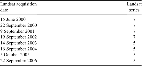
Electromagnetic radiance data were obtained from space-borne, sun-synchronous spectroradiometers, on the platforms Landsat (5) TM and (7) ETM+ for the study area. These systems have been specifically designed for earth observation and land cover monitoring. These data enabled the productivity and pasture composition of the three farmlets to be assessed on eight occasions (Table 1) over the 6.5 years’ duration of the trial, from June 2000 to December 2006. During this time, the farmlet experiment experienced generally drier than average climatic conditions (Behrendt et al. 2013b).
|
The Landsat data were resampled to 25 by 25-m geolocated pixels, using cloud-free days, for all Landsat bands (1–5) along with an NDVI. This resampling provided some 2525 pixels of data over the three farmlets. The numeric treatment of NDVI data in the literature is variable; in this paper, we have chosen to present them as NDVI × 1000 throughout. Project resource constraints meant that only a limited number of Landsat images could be purchased. The dates chosen for these images were first in June 2000, just before the commencement of the experimental treatments and second, in order to obtain estimates of the potential for pasture growth each spring, thereafter in September or October of each year, depending on the availability of overpass dates that were cloud-free (Table 1).
At each image acquisition date, classifications were carried out using all TM bands (except the thermal band) but including the calculated NDVI from the Landsat data. These data were classified into regions of conformity using a clustering procedure followed by an unsupervised maximum likelihood classification using the GIS software ArcGis (ESRI, Sydney, NSW, Australia). These were aggregated to final spectral classes using a dendrogram and relative distance (Mahalanobis) statistics.
The relationship between Landsat spectral classes and botanical composition functional groups was explored across all dates (June 2000 and September/October 2000–06). The spectral classes refer to unsupervised classifications of data across the entire spectrum within each period. It is important to note that spectral classes 1, 2, …, 10 do not necessarily represent the same spectral classes in subsequent periods. However, as reported by Vickery et al. (1997), these spectral classes do suggest that pastures demonstrating similar spectral profiles are likely to be composed of similar types of species. However, it is acknowledged that, in some situations, these spectral reflectance profiles may also be influenced by other biophysical factors such as soil type or fertiliser history (Vickery et al. 1997). The classification analyses were repeated independently for each Landsat NDVI image for the blue, green, RED, NIR and SWIR spectra.
MODIS NDVI data were captured at weekly intervals from early 2003 to the end of 2006, which covered the same period over which pastures were assessed at monthly intervals with visual estimates of herbage mass, green and dead DM, legume, digestibility and ground cover (Shakhane et al. 2013a). Due to the relatively small size of the farmlet paddocks, some of the 250 by 250-m pixels in the MODIS images overlapped across one or more paddocks, or across farmlet boundaries. A total of five 6.25-ha pixels for each farmlet were identified as falling entirely within each farmlet’s boundary. These were chosen for repeated weekly measures of NDVI in order to estimate potential pasture growth at the farmlet scale.
For each week, data were obtained for the five MODIS 6.25-ha pixels on each of the three farmlets, and for eight 6.25-ha pixels on each of two large reference paddocks on the CSIRO McMaster Research Laboratory located within 1 km of the farmlet trial site. These two paddocks were chosen to encompass the expected range of NDVI values, one being a known highly productive paddock (‘Cattle paddock’), which had a long history of sown and fertilised pastures, and the other, a native pasture paddock (‘Middle paddock’), which was known to support only low levels of animal production. Middle paddock, which was comprised mostly of native, warm season perennial pasture grasses, had received no fertiliser for at least 50 years and was grazed only occasionally at a low stocking rate.
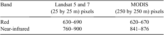
The MODIS image data used in this study were composite images from the radiometers carried on the TERRA and AQUA satellites collected over the same 1-week period. The time of overpass of TERRA satellite was mid morning while the AQUA satellite passed over in the early afternoon. The LandGate, Satellite Remote Sensing Unit in Western Australia provided daily TERRA and AQUA satellite MODIS data that had been systematically calibrated to top-of-atmosphere reflectance and temperature before the NDVI calculations were made. These NDVI data were then composited into weekly images to remove cloud and cloud shadow pixels. The composite procedure used the Maximum Value Composite process of Holben (1986), while in another process, all image data were modified to be free of cloud-affected pixels by replacing such pixels with the particular pixel value from the relevant location recorded during the previous week. Some differences between the NDVI measurements recorded by the Landsat and the MODIS systems are to be expected as the Landsat NDVI is a 1-day snapshot from bandwidths that are slightly different to those used in the MODIS NDVI calculations as shown in Table 2.
|
Statistical analyses
Data for the response variables NDVI and spectral classes were explored against a range of explanatory variables using several exploratory techniques, including Pairplots (Zuur et al. 2007), which provided Pearson correlation coefficients calculated using the software ‘Brodgar’ (version 2.6.6, Highland Statistics Ltd, Newburgh, UK). Normality was confirmed with Q-Q plots. Multi-variate analyses were carried out using redundancy analyses (RDA) (Zuur et al. 2007). Relationships over time were examined using dynamic factor analysis and generalised least-squares modelling fit by REML (Zuur et al. 2007). Linear regression was used to compare results from MODIS and Landsat NDVI data.
The explanatory variables explored were derived from the Cicerone farmlet experiment database (Scott et al. 2013a), which allowed interrogation of a range of potential covariates. These included information published in several companion papers in this Special Issue, namely: soil conductivity (EM31), which was used as a surrogate measure of soil type (Scott et al. 2013b); modelled available soil water (Behrendt et al. 2013a) (ASW_30 or ASW_90) averaged over the previous 30 or 90 days; an average temperature index (TI_30 or TI_90) over the previous 30 or 90 days, a partial growth index (GI_30 or GI_90) (Fitzpatrick and Nix 1975), which was the product of the ASW and TI over the same periods; the stocking rate (Hinch et al. 2013) supported on each paddock over the 30 days before the Landsat image, expressed either as the sum of the number of dry sheep equivalent days (RawDSE) or the sum of weighted DSE (WeightDSE) days (calculated as the sum of 30 daily DSE values ranging from an undiscounted value at 1 day before the image date with linearly discounted DSE values for each day through to 30 days before the image date by which time the DSE value for Day 30 was fully discounted to zero).
Results
Landsat NDVI and spectral classes – before commencement of trial
The Landsat NDVI assessment in June 2000, before the commencement of the farmlet treatments, was similar for all three farmlets (mean Landsat NDVI × 1000) were: A = 259, B = 265, C = 240. These NDVI values were consistent with tall, dry, ungrazed senescent grass, which reflects the pastures at this time following a lengthy period when pastures were ungrazed before commencement of the trial. However, confidence intervals (95%) showed the values of NDVI found on Farmlet C were significantly (P < 0.05) lower than those for Farmlets A or B, which were not significantly different (P > 0.05) from each other. The categorical spectral class data were compared using an ordered logistic regression function in R, polr (R Development Core Team 2009). Thus, in the spectral class data there was no significant difference (P > 0.05) between Farmlets A and B but the values for both farmlets were significantly greater (P < 0.01) than those from Farmlet C.
A multi-variate RDA (Zuur et al. 2007) using the software program ‘Brodgar’ (version 2.6.6), of NDVI and spectral classes as response variables at June 2000, showed a weak (sum of all eigenvalues = 0.06), but significant (P < 0.01) relationship with paddocks. However, there was no relationship with farmlet treatment, which was to be expected, as no management interventions had been applied before the commencement of the trial. Further, there were no significant differences between farmlets for NDVI or spectral classes when examined with EM31 measurements interpolated for each Landsat pixel. The EM31 measurements for this trial have been described in detail in a companion paper on the planning of the farmlet trial by Scott et al. (2013b), which found that the variation in soil conductivity, before allocating land areas to farmlets was small and not significant.
Landsat NDVI – spring measurements (2000–06)
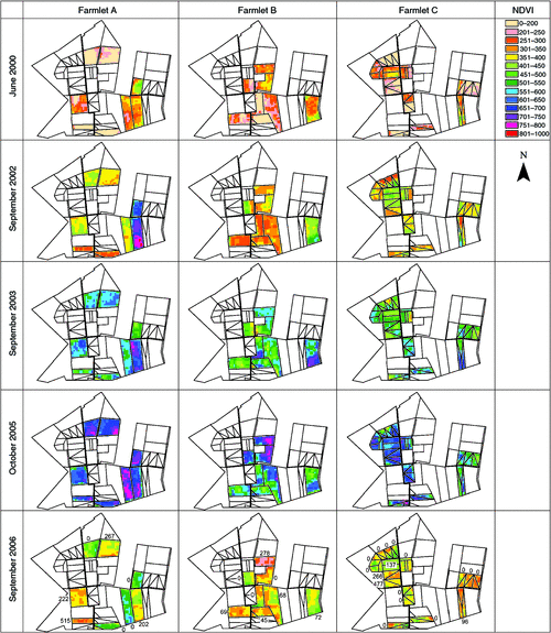
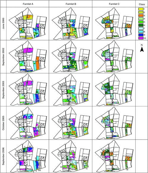
After farmlet treatments commenced, differences in the spectral responses of the pastures changed over time and space as shown in Fig. 1. These colour images of Landsat NDVI measured across the many pixels comprising every paddock of each farmlet showed that, while the differences between farmlets were small in June 2000, the differences increased with time, especially in response to management treatments during favourable seasons. For example, even in the driest year (2002), it was easy to identify two newly sown paddocks on Farmlet A (Fig. 1) as they clearly had the highest levels of NDVI reflecting their newly sown, ungrazed state at this time. This figure also shows large differences between years, with 2004 and 2006 being largely dry while 2005 was the wettest spring experienced during the trial. The images for September 2006 have been annotated with numbers adjacent to or within paddocks indicating the weighted DSE/ha grazed on those paddocks across all three farmlets over the previous 30 days. These clearly show the linkage between the NDVI value and grazing, with high values tending to be associated with less recent grazing while the reverse was true for low values.
|
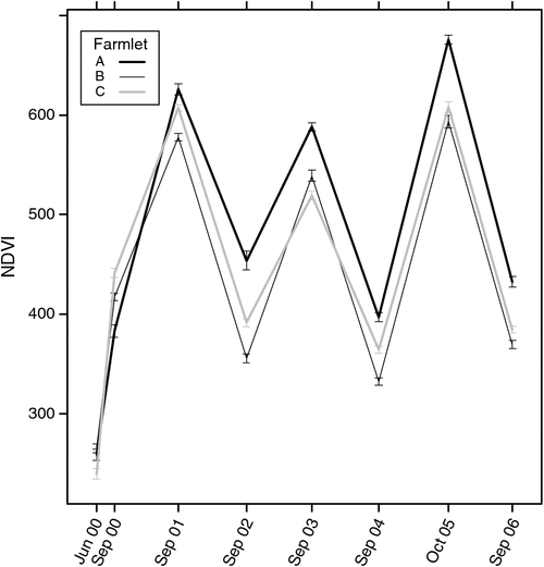
Figure 2 shows the mean and 95% confidence intervals for Landsat NDVI for the three farmlets over all measurement dates. It is clear that, although there were several times when Farmlets B and C were different from each other in NDVI, these differences were relatively minor and inconsistent. The major significant difference was the significantly higher NDVI on Farmlet A compared with the other two farmlets. Thus, Farmlet A had a significantly higher (P < 0.05) level of potential pasture growth (high NDVI) over all times from September 2002 onwards (some 2.25 years after the first pasture renovation took place).
|
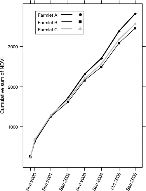
As shown by the cumulative NDVI data (representing cumulative potential pasture growth) (Fig. 3), after September 2002, there was a tendency for the differences in NDVI between the farmlets to increase somewhat over time. In that figure, the steepest slopes tended to be associated with the wetter years (2001, 2003 and 2005) while the drier years tended to have gentler slopes. It is clear that Farmlet A had the highest cumulative potential pasture growth followed by Farmlets C and B in that order. Although the cumulative potential pasture growth was higher on Farmlet C than on Farmlet B, it is noteworthy that the green herbage was not as available to the grazing animals on Farmlet C as on Farmlet B as a much smaller proportion of Farmlet C was grazed (Hinch et al. 2013) at any point in time.
|
When examining a separate multi-variate RDA for NDVI or spectral classes at the last Landsat measurement date (September 2006) near the end of the trial, it was obvious that the farm treatments had resulted in significant changes in both NDVI and pasture spectral classes. The magnitude of these changes was significantly affected by the surrogate measure of soil type (EM31, soil conductivity). Compared with the June 2000 RDA, this analysis showed a stronger relationship (sum of all eigenvalues = 0.19) with significant (P < 0.01) effects of farmlet, paddock and soil conductivity (EM31) value in decreasing order of importance. The effect of soil conductivity, while minor compared with farmlet and paddock management effects, nevertheless significantly influenced the values of both NDVI and spectral classes.
While NDVI is well known to be a measure of greenness that is closely associated with potential pasture growth rate, spectral classes have been shown to be associated with botanical composition groups (Vickery et al. 1997). Figure 4 shows colour images of spectral classes for individual pixels across all paddocks and farmlets for selected times from June 2000 to September/October of 2002, 2003, 2005 and 2006. Over time, it is clear that Farmlet A had more extensive areas with high spectral class values associated with improved pastures (see below) and appeared to be more homogeneous across some of the paddocks. Again, as with the colour NDVI images (Fig. 1), the differences between paddocks that are clearly visible in Fig. 4 demonstrate distinct differences likely to be useful to managers of variable farm landscapes. In general, the differences in spectral class values were greater between farmlets than between years.
|
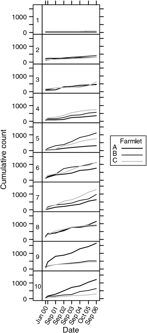
Figure 5 shows the cumulative count of pixels categorised as spectral classes 1–10 for each farmlet over time. For classes 1–3 and 8, there is a similar distribution of counts for all farmlets. However, for classes 4–7 and 9–10, there were large differences between farmlets over time with Farmlet A having lower counts for classes 4–7 and much higher counts for classes 9–10 than for Farmlets B and C. This was presumably associated with the higher levels of pasture renovation and soil fertility which occurred over time on Farmlet A.
|
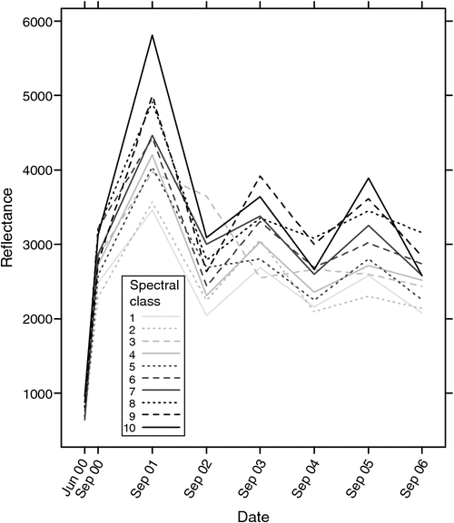
The classification analyses for the blue, green, RED, NIR and SWIR bands of each Landsat NDVI image showed that, while all exhibited some relationship between reflectance and class over time, the reflectance values for the NIR band showed the most consistently ordered relationship with classes. Figure 6 shows that the spectral classes 1, 2, …, 10 were not independent; indeed, it appears that the order of spectral classes of pasture response at each Landsat image acquisition date were similar. Vickery et al. (1997) proposed, when delineating Landsat spectra between fast to medium to slow growing pastures, that the classification procedure depended largely upon pasture greenness which was likely to be linked to pasture functional groups. The overall fluctuations in the reflectance values in Fig. 6 are consistent with the seasonal conditions experienced in spring of each year with the higher values occurring in the wetter springs (2001, 2003 and 2005) and the lower values in the remaining drier spring seasons.
|
The significance of the variation in NDVI and spectral classes with botanical composition groups was explored with multi-variate RDA, which showed that both NDVI and especially spectral classes were significantly correlated with sown perennial grasses, cool season annual grasses and legumes while they were both negatively correlated with year-long green grasses and warm season grasses (Fig. 7). Removing factors that were not significant (farmlet) and those that caused high variance inflation factors, which indicated collinearity (e.g. pasture age), revealed a sum of all canonical eigenvalues of 0.2 and the following significant (P < 0.01) factors: Sowing Phase (sown v. volunteer pasture), Date, NDVI and Paddock. Spectral classes had a strong relationship with botanical composition groups (longer line) but it was slightly less significant (P < 0.05) than NDVI (P < 0.01).

|
The relationships between Landsat NDVI and spectral classes was also investigated with several other explanatory variables including modelled ASW_30 or ASW_90, TI_30 or TI_90, GI_30 or GI_90, and the stocking rate on each paddock over the previous 30 days (RawDSE or WeightDSE days).
Pearson correlation coefficients showed that Landsat NDVI was most strongly correlated (positively) with ASW_90 (0.53) and then GI_30 (0.41) while spectral classes were positively correlated with Weighted DSE days (0.33).
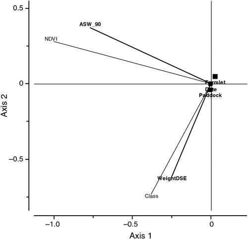
An RDA of Landsat NDVI and spectral classes as response variables with all of the above explanatory variables showed that Farm, Paddock, Date, ASW_90, and Weighted DSE days were all significant (P < 0.01) explanatory variables. GI_30 and TI_30 were strongly collinear and were removed from the analysis as was RawDSE, which was not significantly related to NDVI or spectral classes. Figure 8 shows a biplot, which displays the relationship between all of these significantly related variables. It is noteworthy that NDVI was strongly correlated with ASW_90 and less so with Date indicating that the major effect was between years. In contrast, spectral classes were not correlated with NDVI nor with Date, suggesting that spectral class was independent of effects of Date per se. However, spectral classes were strongly correlated with Weighted DSE days suggesting that grazing of the paddock over the 30 days before the Landsat image significantly affected the spectral classes. As in Fig. 1, the images for September 2006 in Fig. 4 have been annotated with numbers adjacent to or within paddocks indicating the Weighted DSE/ha grazed on those paddocks across all three farmlets over the previous 30 days. As with the NDVI images (Fig. 1), the annotated spectral class images for September 2006 in Fig. 4 demonstrate an association with recent grazing in individual paddocks with high spectral class values tending to be linked to high values of recent grazing. A further RDA (Fig. 8) shows a significant positive correlation between spectral class and stocking rate over all paddocks (WeightDSE).
|
MODIS NDVI
The MODIS NDVI data provided an overview of the changes in greenness at weekly intervals over the period from 2 September 2003 to 26 December 2006. Pearson correlation coefficients of MODIS NDVI across all five paddocks showed correlations with a weekly GI (0.56–0.59), TI (0.54–0.60), ASW (0.26–0.29) and Date of acquisition (0.25–0.28). Fitted lines using dynamic factor analysis for the three farmlet paddocks and the two reference paddocks over 174 weeks (not presented) showed that throughout the measurement period the highly fertilised and sown ‘Cattle’ paddock had the highest NDVI values, with the low fertility ‘Middle’ paddock much lower NDVI values, while Farmlets A, B and C were all similar to each other and just below the ‘Cattle’ paddock NDVI values.
Calculated values of a daily, partial GI (Fitzpatrick and Nix 1975), the product of a temperature index for temperate species calculated using minimum and maximum daily temperature records for Armidale multiplied by daily modelled ASW (Behrendt et al. 2013b), showed a consistent pattern between GI and MODIS NDVI. A multi-variate RDA of the NDVI data from the five paddocks, with explanatory variables (data not presented), showed significant effects (sum of all canonical eigenvalues = 0.39) of Date and GI (P < 0.01) confirming that the MODIS NDVI data were strongly and positively linked to the climatic variables of temperature and soil moisture. The pattern of peaks and troughs of the fitted lines closely resembled the pattern of growth observed using grazing exclosure cages (Shakhane et al. 2013a).
An analysis of MODIS-NDVI data using a generalised least-squares model showed that Farmlet, Date of image acquisition and the interaction between Farmlet and Date of image acquisition were all highly significant (P < 0.0001) indicating that relative differences changed over time.
Using linear regression, the NDVI values for the Landsat satellite data from September 2003 to September 2006 were compared with those from the MODIS radiometers obtained at similar acquisition dates. This regression, shown in Eqn 1, had an R2 value of 0.88, RMSE ± 45.2 and was highly significant (P < 0.0001 with 58 degrees of freedom), where NDVI is NDVI × 1000.

This highly significant relationship confirms that the NDVI measured by both the MODIS and Landsat satellite sensors were indeed similar. Some differences between the Landsat and MODIS NDVI measurements are to be expected because of issues such as ground registration errors and the slight differences in the wavelengths used by the radiometers in each system (Table 2).
Discussion
Recent improvements in the accessibility of satellite data meant that Landsat and MODIS images were able to be acquired for the Cicerone farmlet experiment after the trial had finished. It is therefore notable that these post hoc analyses have added considerable value to the experiment by quantifying some important differences between the three farmlets. The findings of these remote sensing analyses were also in agreement with other post hoc analyses. For example, finding that the soil conductivity (EM31) measurement made before the trial commencing (June 2000), although not significant between farmlets at that time (Scott et al. 2013b), did show measurable differences which increased as time progressed, thus demonstrating that soil type effects became more evident once the management treatments, such as higher soil fertility, had been applied to the farmlets.
The co-occurrence of measurable differences from unrelated technologies shows the value of multi-disciplinary approaches by providing a means of ‘triangulation’ to confirm differences in farming system performance. This is consistent with findings of Hill and Donald (2003) who noted the value of NDVI time series data to assessments of production responses, either through vegetation or by stocking rate, even when using retrospective analyses, such as those made here with the Cicerone farmlet trial. Similarly, the value of NDVI time series data has been recognised in southern Spain, where studies examined vegetation patterns under different managements as influenced by variations in precipitation and temperature (Durante et al. 2009).
The value of the Landsat data acquired in spring became more apparent with time. While interpreting the temporal changes in Landsat NDVI and spectral classes is a complex issue, it is clear that, over time, Farmlet A exhibited quite different spectral reflectance characteristics to Farmlets B and C, which did not differ greatly from each other. The differences in potential growth rate that were observed using the Landsat NDVI measurements each spring demonstrated the clear advantages that remote sensing techniques have over more direct sampling techniques using small grazing exclosure cages (Shakhane et al. 2013a). The latter are limited by the insignificant proportion of a farmlet that can be sampled with such techniques and also by the high labour required to take an adequate number of samples to obtain statistically valid data. Others have also found spring measurements using MODIS NDVI to be especially useful for assessing species composition of temperate grasslands, for example in Argentina, where discrimination between various plant communities was greatest in that season (Aragón and Oesterheld 2008).
The most important findings from the remote sensing imagery were that significant differences were able to be established: (i) between farmlets and individual paddocks differing in sowing and fertiliser strategies, (ii) between seasons differing in soil moisture and temperature, and (iii) between paddocks that had been subjected to different recent grazing intensities.
The significance of different explanatory factors showed that ‘Sowing Phase’ and management treatments (different sowing and soil fertility strategies) had large effects on both NDVI and spectral classes. It is nevertheless clear that NDVI and spectral classes were measuring quite different attributes. In the case of NDVI, the measurements capture just two regions of the spectrum related to photosynthetic capacity of the pasture, being based on the RED to NIR ratio. This ratio was first identified as useful by Tucker (1979) who found that NDVI was well suited to the monitoring of photosynthetically active biomass of plant canopies. In the case of pastures, this relates to measurements of the level of green herbage mass which is well known to be one of the principal drivers of animal production as described by many authors. Sequential NDVI measurements have also been shown to a valuable means of estimating herbage quality by documenting the onset of vegetation greening, senescence and inter-annual variability of different types of grasslands in North Dakota, USA (Reed et al. 1994).
In contrast to the limited parts of the spectrum covered by NDVI, the Landsat spectral class data represent reflectance across the visible spectrum and the NIR, used to calculate NDVI. Clearly the addition of the blue, green and additional infrared spectral bands further enhances the information that can be gained through the acquisition of remotely sensed reflectance data. Thus the spectral classes reflect the strength of the individual spectral signatures of the treatments on Farmlets A, B and C. Using experimental data from the same region of the Northern Tablelands of NSW, Vickery et al. (1997) found Landsat TM satellite imagery could be classified in such a way that it could be used to differentiate between highly improved perennial grass pastures, less productive improved pastures and native pastures. In this farmlet experiment, significant associations between spectral classes and botanical composition functional groups confirm the findings of Vickery et al. (1997) and support the findings of Shakhane et al. (2013b) who found that Farmlet A maintained significantly higher levels of sown annual and perennial grasses and legumes, compared with Farmlets B and C.
Although the differences between farmlets in the weekly MODIS NDVI data were slight, these data were nevertheless useful in that they demonstrated the relative growth potential of each of the farmlets compared with one low and one high growth rate reference paddock. The finding that these data were significantly linked to a calculated partial growth index, based on temperature and modelled soil moisture, confirms that NDVI reflects changes in the potential for pasture growth.
Another important finding is that MODIS NDVI potential growth patterns showed that all three trial farmlets were much closer in potential growth to the high growth reference paddock than the unfertilised, low growth reference paddock. This confirms one of the aims of the design of the experimental farmlet treatments, that Cicerone producer members were more interested in studying moderate to high input systems than systems receiving little or no management inputs (Scott et al. 2013a).
The development of tools based on satellite remote sensing and simulation modelling when applied to issues such as the spatial variability of pasture growth at a farm scale can give valuable historical insights into grassland utilisation (Vickery et al. 1999). The study by Vickery et al. examined modelled net primary production in relation to pasture type, pasture condition, climate and soil fertility and suggested this type of information would be suited to precision management of grazing systems. The application of NDVI data obtained from remote sensing/satellite systems such as SPOT, Landsat ETM and MODIS, at resolutions of 10, 25 and 250 m, respectively, provide an opportunity to extend historic assessments of pastures to near real time assessments of land cover for both farm and land-use management.
Conclusions
We conclude that these remote sensing images of the Cicerone farmlet experiment have indeed shown that important and significant differences occurred between farmlets as management impacts and seasonal conditions took effect. These techniques have been confirmed as valuable aids for objectively measuring whole paddock and farmlet attributes which affect livestock production. It is clear that, in time, these methods have the potential to evolve into ‘real time’ applications, to facilitate the difficult management decisions faced by livestock producers, especially given the existing and potential future variability of climatic conditions. Such applications would assist in decisions relating to pasture renovation, maintaining pasture composition, maintaining soil fertility, as well as adjusting stocking rates and grazing management across every paddock of entire farms.
Acknowledgements
The assistance of LandGate Western Australia in providing MODIS and Landsat imagery is gratefully acknowledged. The technical assistance of Cate Macgregor is also greatly appreciated. This study was part of the Cicerone Project, which was funded by wool growers and the Australian taxpayer through Australian Wool Innovation as well as through in-kind contributions from the University of New England, NSW Department of Primary Industries and CSIRO Livestock Industries.
References
Aragón R, Oesterheld M (2008) Linking vegetation heterogeneity and functional attributes of temperate grasslands through remote sensing. Applied Vegetation Science 11, 117–130.| Linking vegetation heterogeneity and functional attributes of temperate grasslands through remote sensing.Crossref | GoogleScholarGoogle Scholar |
Behrendt K, Cacho O, Scott JM, Jones R (2013a) Optimising pasture and grazing management decisions on the Cicerone Project farmlets over variable time horizons. Animal Production Science 53, 796–805.
| Optimising pasture and grazing management decisions on the Cicerone Project farmlets over variable time horizons.Crossref | GoogleScholarGoogle Scholar |
Behrendt K, Scott JM, Mackay DF, Murison R (2013b) Comparing the climate experienced during the Cicerone farmlet experiment against the climatic record. Animal Production Science 53, 658–669.
| Comparing the climate experienced during the Cicerone farmlet experiment against the climatic record.Crossref | GoogleScholarGoogle Scholar |
Bureau of Meteorology (2011) ‘Climate statistics for Australian locations.’ (Bureau of Meteorology: Melbourne, Vic.) Available at http://www.bom.gov.au/climate/averages/tables/cw_056002.shtml [Verified 21 June 2012]
Durante P, Oyonarte C, Valladares F (2009) Influence of land-use types and climatic variables on seasonal patterns of NDVI in Mediterranean Iberian ecosystems. Applied Vegetation Science 12, 177–185.
| Influence of land-use types and climatic variables on seasonal patterns of NDVI in Mediterranean Iberian ecosystems.Crossref | GoogleScholarGoogle Scholar |
Edirisinghe A, Hill MJ, Donald GE, Hyder M, Warren B, Wheaton GA, Smith RCG (2000) Estimating feed-on-offer and pasture growth rate using remote sensing. In ‘Proceedings of the 10th Australasian remote sensing and photogrammetry conference’. (CD-ROM)
Fitzpatrick EA, Nix HA (1975) The climate factor in Australian grassland ecology. In ‘Australian grasslands’. (Ed. RM Moore) pp. 3–26. (ANU Press: Canberra)
Flynn S (2006) ‘Using NDVI as a pasture management tool.’ (University of Kentucky: Lexington, KY) 53 pp.
Friedl MA, Michaelsen J, Davis FW, Walker H, Schimel DS (1994) Estimating grassland biomass and leaf area index using ground and satellite data. International Journal of Remote Sensing 15, 1401–1420.
| Estimating grassland biomass and leaf area index using ground and satellite data.Crossref | GoogleScholarGoogle Scholar |
Hill MJ, Donald GE (2003) Estimating spatio-temporal patterns of agricultural productivity in fragmented landscapes using AVHRR NDVI time series. Remote Sensing of Environment 84, 367–384.
| Estimating spatio-temporal patterns of agricultural productivity in fragmented landscapes using AVHRR NDVI time series.Crossref | GoogleScholarGoogle Scholar |
Hill MJ, Donald GE, Vickery PJ, Furnival EP (1996) Integration of satellite remote sensing, simple bioclimatic models and GIS for assessment of pastoral development for a commercial grazing enterprise. Australian Journal of Experimental Agriculture 36, 309–321.
| Integration of satellite remote sensing, simple bioclimatic models and GIS for assessment of pastoral development for a commercial grazing enterprise.Crossref | GoogleScholarGoogle Scholar |
Hill MJ, Vickery PJ, Furnival EP, Donald GE (1999) Pasture land cover in eastern Australia from NOAA-AVHRR NDVI and classified Landsat TM. Remote Sensing of Environment 67, 32–50.
| Pasture land cover in eastern Australia from NOAA-AVHRR NDVI and classified Landsat TM.Crossref | GoogleScholarGoogle Scholar |
Hill MJ, Donald GE, Hyder MW, Smith RCG (2004) Estimation of pasture growth rate in the south west of Western Australia from AVHRR NDVI and climate data. Remote Sensing of Environment 93, 528–545.
| Estimation of pasture growth rate in the south west of Western Australia from AVHRR NDVI and climate data.Crossref | GoogleScholarGoogle Scholar |
Hill MJ, Ticehurst CJ, Lee JS, Grunes MR, Donald GE, Henry D (2005) Integration of optical and radar classifications for mapping pasture type in western Australia. IEEE Transactions on Geoscience and Remote Sensing 43, 1665–1681.
| Integration of optical and radar classifications for mapping pasture type in western Australia.Crossref | GoogleScholarGoogle Scholar |
Hinch GN, Hoad J, Lollback M, Hatcher S, Marchant R, Colvin A, Scott JM, Mackay D (2013) Livestock weights in response to three whole-farmlet management systems. Animal Production Science 53, 727–739.
| Livestock weights in response to three whole-farmlet management systems.Crossref | GoogleScholarGoogle Scholar |
Holben BN (1986) Characteristics of maximum-value composite images from temporal AVHRR data. International Journal of Remote Sensing 7, 1417–1434.
| Characteristics of maximum-value composite images from temporal AVHRR data.Crossref | GoogleScholarGoogle Scholar |
R Development Core Team (2009) ‘R: a language and environment for statistical computing.’ (R Foundation for Statistical Computing) Available at http://www.R-project.org [Verified 20 June 2012]
Reed BC, Brown JF, VanderZee D, Loveland TR, Merchant JW, Ohlen DO (1994) Measuring phenological variability from satellite imagery. Journal of Vegetation Science 5, 703–714.
| Measuring phenological variability from satellite imagery.Crossref | GoogleScholarGoogle Scholar |
Rouse JW, Haas RH, Schell JA, Deering DW (1973) Monitoring vegetation systems in the Great Plains with ERTS. In ‘Proceedings of the 3rd ERTS symposium’. (Eds SC Freden, EP Mercanti, MA Becker) pp. 309–317. (NASA: Washington, DC)
Scott JM, Gaden CA, Edwards C, Paull DR, Marchant R, Hoad J, Sutherland H, Coventry T, Dutton P (2013a) Selection of experimental treatments, methods used and evolution of management guidelines for comparing and measuring three grazed farmlet systems. Animal Production Science 53, 628–642.
| Selection of experimental treatments, methods used and evolution of management guidelines for comparing and measuring three grazed farmlet systems.Crossref | GoogleScholarGoogle Scholar |
Scott JM, Munro M, Rollings N, Browne W, Vickery PJ, Macgregor C, Donald GE, Sutherland H (2013b) Planning for whole-farm systems research at a credible scale: subdividing land into farmlets with equivalent initial conditions. Animal Production Science 53, 618–627.
| Planning for whole-farm systems research at a credible scale: subdividing land into farmlets with equivalent initial conditions.Crossref | GoogleScholarGoogle Scholar |
Shakhane LM, Mulcahy C, Scott JM, Hinch GN, Donald GE, Mackay DF (2013a) Pasture herbage mass, quality and growth in response to three whole-farmlet management systems. Animal Production Science 53, 685–698.
| Pasture herbage mass, quality and growth in response to three whole-farmlet management systems.Crossref | GoogleScholarGoogle Scholar |
Shakhane LM, Scott JM, Murison R, Mulcahy C, Hinch GN, Morrow A, Mackay DF (2013b) Changes in botanical composition on three farmlets subjected to different pasture and grazing management strategies. Animal Production Science 53, 670–684.
| Changes in botanical composition on three farmlets subjected to different pasture and grazing management strategies.Crossref | GoogleScholarGoogle Scholar |
Trotter MG, Lamb DW, Donald GE, Schneider DA (2010) Evaluating an active optical sensor for quantifying and mapping green herbage mass and growth in a perennial grass pasture. Crop and Pasture Science 61, 389–398.
| Evaluating an active optical sensor for quantifying and mapping green herbage mass and growth in a perennial grass pasture.Crossref | GoogleScholarGoogle Scholar |
Tucker CJ (1979) Red and photographic infrared linear combinations for monitoring vegetation. Remote Sensing of Environment 8, 127–150.
| Red and photographic infrared linear combinations for monitoring vegetation.Crossref | GoogleScholarGoogle Scholar |
Vickery PJ, Hill MJ, Donald GE (1997) Satellite derived maps of pasture growth status: association of classification with botanical composition. Australian Journal of Experimental Agriculture 37, 547–562.
| Satellite derived maps of pasture growth status: association of classification with botanical composition.Crossref | GoogleScholarGoogle Scholar |
Vickery PJ, Moore AD, Donnelly JR, Hill MJ, Donald GE (1999) Combining satellite data with a simulation model to describe spatial variability in pasture growth at a farm scale. Australian Journal of Experimental Agriculture 39, 285–300.
| Combining satellite data with a simulation model to describe spatial variability in pasture growth at a farm scale.Crossref | GoogleScholarGoogle Scholar |
Zuur AF, Ieno EN, Smith GM (2007) ‘Analysing ecological data.’ (Springer: New York)