

Community uses and values of water informing water quality improvement planning: a study from the Great Barrier Reef region, Australia
Iris C. Bohnet A C and Clarence Kinjun BA CSIRO Sustainable Ecosystems, PO Box 780, Atherton, Qld 4883, Australia.
B Girringun Aboriginal Corporation, PO Box 303, Cardwell, Qld 4849, Australia.
C Corresponding author. Email: iris.bohnet@csiro.au
Marine and Freshwater Research 60(11) 1176-1182 https://doi.org/10.1071/MF08329
Submitted: 1 December 2008 Accepted: 23 July 2009 Published: 17 November 2009
Abstract
Community participation has gained widespread recognition in water management and planning for its potential to inform management plans and gain community support for actions that are aligned with the community’s water values. However, the practical application of community participation remains challenging as there is no consensus on who should be involved and why. During a participatory research project to inform the Tully Water Quality Improvement Plan (WQIP), the local community was involved in qualitative interviews and workshops to identify the water uses and values in the Tully basin. The results showed that these waters are extensively used and valued via a wide range of activities and that water is more than an economic good. All participants valued the aquatic ecosystems, which provide the basis for setting the most stringent water quality objectives (WQOs). Moreover, the results showed that many of the current uses and values of waters are under serious threat and that some uses and values have been lost over time. These findings informed the setting of the WQOs for the Tully WQIP to protect and re-establish the water uses and values that the local community supports.
Additional keywords: community engagement, environmental values, participatory planning, reef plan, Tully Water Quality Improvement Plan.
Introduction
In recent years, community participation has gained widespread international recognition in water management and planning for its potential to inform management plans and to gain community support for actions that are aligned with the community’s water uses and values (Mostert 2003; Hophmayer-Tokich and Krozer 2008). Many international declarations advocate a participatory approach to water management and planning involving users, planners and policy makers at all levels (e.g. ACC/ISGWR 1992). In addition, some conventions and regulations contain specific requirements, such as the EU Water Framework Directive (EU 2000/60/EC) (European Union 2000), mandating public participation in water management and planning.
In Australia, one key element of national water planning is the National Water Quality Management Strategy (NWQMS). The main policy objective of the NWQMS is ‘to achieve sustainable use of the nation’s water resources by protecting and enhancing their quality, while maintaining economic and social development’ (ANZECC 1994). The NWQMS provides policies, a process and a series of national guidelines to help communities manage their water resources (ANZECC 1998). The NWQMS considers community participation in water management critical to: (i) identify the preferred uses of local water bodies; and (ii) develop community acceptance in relation to the costs associated with improved water quality.
In the Great Barrier Reef (GBR) region of Australia, the Australian and Queensland Governments jointly developed and launched the Reef Water Quality Protection Plan (the ‘Reef Plan’; Anon. 2003) to protect the GBR and its environmental values from land-based sources of pollution (see Kroon 2009 for more detail). Actions to implement the Reef Plan include the development of local Water Quality Improvement Plans (WQIPs). The development of WQIPs builds on key elements of the NWQMS and requires community participation to identify the preferred uses and values of local water bodies and to develop acceptance of the actions required to improve water quality.
However, despite international recognition of the importance of community participation in water management and planning, the practical application of a participatory approach remains challenging because there is no consensus on who should be involved and what the outcomes of the participatory process should be (Webler and Tuler 2001). In the past, public participation used to refer to opportunities for providing comments at public hearings, whereas, more recently, public participation refers to a variety of procedures for enabling members of the public to be active participants in deliberations about policy, planning and management options (Renn et al. 1995). Different views, however, exist about how to involve the public (Webler and Tuler 2001) and this greatly influences who is invited to participate and, consequently, the outcome of the participation. Although high levels of public participation are often regarded as a central component of an effective planning process (Brody 2003), many scholars argue that the participation of key stakeholders is the single most important element of a successful outcome (Duram and Brown 1999; Mccool and Guthrie 2001). In contrast, Luz (2000) argues that the people affected by a new policy or management plan should be involved in the planning process from which the changed action is intended to result.
The objective of the present study was to: (i) identify the community uses and values of waters in the Tully basin and associated coastal and marine environments as required by the NWQMS; (ii) uncover potential conflicts between different water uses and values and stakeholder groups; and (iii) translate and prioritise the community uses and values of water into the water planning framework. Uncovering conflicts between the uses and values of water and user groups and working through those conflicts with the stakeholder groups is essential to making water quality improvement planning more inclusive and transparent and potentially more successful in achieving its implementation goals.
Materials and methods
Tully basin study area
The study area comprised the Tully basin (2910 km2) and associated coastal and marine waters (fig. 1 in Kroon 2009). The dominant land uses in the Tully basin are nature conservation, sugarcane, grazing, horticulture and plantation forestry (Armour et al. 2009). World Heritage-listed rainforest occupies ~64% of the basin in the higher elevation and upper reaches of the rivers and creeks, whereas cleared cultivated land and remnant patches of rainforest are found on the alluvial plains, and wetlands and estuaries are found near the sandy coast.
The marine area influenced by discharging waters from the Tully basin (~2000 km2) (Devlin and Schaffelke 2009) represents five of 70 bioregions within the GBR Marine Park (GBRMPA 2001). Parts of the GBR Marine Park in this region are subject to a Traditional Use of Marine Resource Agreement (TUMRA) signed by six saltwater traditional owner groups in 2005 and accredited by State and Australian Government marine management agencies.
Definition of water bodies in the Tully basin
For the purpose of the present study, water bodies included both waters in the basin (sensu Kingsford et al. 2005), as well as the coastal and marine waters within the marine area influenced by discharging waters from the basin (Devlin and Schaffelke 2009). Water bodies in the basin include permanent and ephemeral rivers, creeks, wetlands, lagoons, lakes, salt marshes, mudflats, mangroves, coral reefs and artificial bodies of water (Kingsford et al. 2005; Department of Environment and Heritage 2006).
Environmental values and water quality objectives
A broad framework for setting environmental values (EVs), that is, the preferred uses and values of local water bodies, was established through the NWQMS (ANZECC 1994, 1998). In addition, in the State of Queensland, this framework is embedded in the Environmental Protection (Water) Policy 1997 (State of Queensland 1997). The EVs are categorised into aquatic ecosystems, primary industries, recreation and aesthetics, drinking water, industrial uses, and cultural and spiritual values. Draft water quality objectives (WQOs) are based on both the community’s preferred EVs and the water quality guidelines and standards set to protect them (ANZECC 2000). The WQOs are measurable indicators of the characteristics needed to protect the EVs of particular waterways. After considering the social, economic and environmental impacts of the actions that might be required to achieve the desired improvements in the quality of the waters, the EVs, WQOs and management goals may be revised in an iterative process until the impacts of the required actions are acceptable to the community.
Who should be involved in the identification of environmental values?
Although the national and state guidelines for establishing draft EVs (ANZECC 1994, 1998; EPA 2005) provide a broad framework with regard to the process of identifying EVs and setting WQOs, they do not specify who is meant by ‘community’, that is, who should be consulted about their water uses and values? This is of particular importance in the GBR region because downstream communities may include a wide range of perspectives and interests derived from local, regional and international reef users, industries and conservation groups.
Based on the ‘checklist of possible interests’ provided in the NWQMS (ANZECC 1998), a review of selected participatory planning projects in the field of water management and planning (Beierle and Konisky 2001; Brody 2003; Quaghebeur et al. 2004; Kroon et al. 2006) as well as a stakeholder mapping exercise, we decided to carry out the research primarily with the local community, that is, the people living in the geographical area covering the Tully basin, who should support the EVs and WQOs (ANZECC 1998; Luz 2000). In the stakeholder mapping exercise, we identified a wide range of local community members representing different interests and values, including traditional owners, other indigenous people, farmers, industry, non-farming residents, conservation groups and the interested and concerned public, who should be involved and represented in the research.
Identification of the community uses and values of water in the Tully basin
We used a two-staged participatory approach following a social–ecological framework for sustainable landscape planning (Bohnet and Smith 2007).
Qualitative interviews
In the first stage of the research, we interviewed individual community members on a one-to-one basis (Bohnet et al. 2006). We purposely selected interviewees (Silverman 2000) based on their particular connection to the basin as identified in the stakeholder mapping exercise. This included primary producers from different locations and age groups within the basin who, we assumed, depend on the basin waters for their livelihoods, and traditional owners who, we assumed, have an obligation to look after particular areas of country. We obtained the names of potential interviewees from industry representatives, agricultural extension officers and the Girringun Aboriginal Corporation. To reach the wider community, we distributed a project flyer in the study area and placed an article in the local newspaper to invite participation in the project. In addition, we used a ‘snowballing’ technique (Miles and Huberman 1994), where one person introduces the interviewers to others, which provided the interviewers with access to interviewees that were missing in their sample according to the stakeholder mapping exercise.
The interviews were semi-structured and tailored towards the different user (stakeholder) groups to ensure that the researchers covered all potential EVs (EPA 2005). The questions were open ended to allow: (i) follow-up prompts to encourage deeper exploration of the EVs identified by the respondents; (ii) exploration of additional water uses and values; and (iii) discussion of past water uses and values that had been lost over time and potential conflicts. All interviews were recorded, transcribed verbatim and analysed using the qualitative software package ATLAS.ti (Muhr 1997). All information related to the EVs in the basin and associated coastal and marine environments was coded according to the EV classification provided by the Environmental Protection Agency (EPA). Additional EVs were also coded and given a different label related to the EV recorded. Contextual information, such as threats and other issues related to EVs, user (stakeholder) groups, lost EVs and conflict between uses, was also coded and links between codes, known as nodes, were established.
Community workshops
Community workshops in different sub-basins were held in stage two of the research to determine past, current and preferred future water uses and values and associated spatial locations (Bohnet et al. 2007). To inform and invite the community to participate in a workshop, we placed an article in the local newspaper. In addition, we promoted the workshops on local radio and sent out invitations to the interviewees.
To stimulate discussion and learning among the participants, which is a prerequisite for communities to adapt and respond to change (Barker 2005; Mostert et al. 2007, 2008), we composed workshop groups of individuals representing potentially different views and interests. The size of the workshop groups was kept to a ‘manageable’ level of between 8 and 12 participants; this allowed discussion to occur and maximised active participation by all participants (Denzin and Lincoln 2007).
A series of basin maps and some key questions about local rivers, creeks, wetlands, swamps, mangroves, and coastal and marine areas guided the community workshops (Bohnet et al. 2007). The workshops consisted of individual and group work as well as group discussion. With the participants’ consent, all workshops were recorded and the transcripts, along with the participants’ annotations of basin maps and rough notes, provided the raw data for input into ATLAS.ti (Muhr 1997). We imported the annotated workshop maps and rough notes as images into ATLAS.ti and sections of the images were coded according to the EVs and the spatial locations of the EVs. We coded the workshop transcripts, similar to the interviews, and established links between codes (nodes) to help identify common patterns in the data. We organised the results from the community workshops according to the EPA’s suite of EVs and linked the identified EVs to the rivers, creeks, swamps, wetlands, dams, estuaries, beaches and marine environments that were discussed in each of the sub-basin held workshops. Furthermore, the workshop participants identified additional local creeks and wetlands and their uses and values were recorded.
Results
Community uses and values of water in the Tully basin
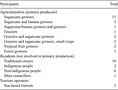
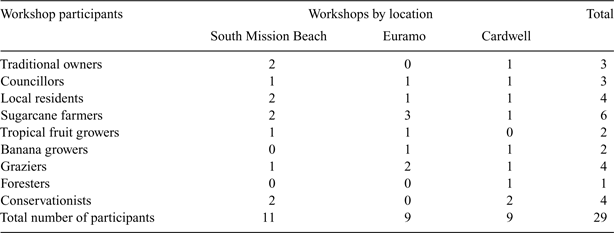
We conducted 41 qualitative interviews with 49 respondents (Table 1) and three community workshops with 29 participants (Table 2). The interviewees and workshop participants included a diverse range of local community members, including traditional owners, other indigenous people, sugarcane farmers, banana growers, tropical fruit growers, graziers, foresters, tourism operators, councillors, local (non-farming) residents and conservation representatives (Tables 1, 2). Sixteen of the 29 workshop participants contributed to the research via an interview, confirming the importance of establishing rapport with community stakeholders in order for them to feel comfortable attending a workshop and to be sufficiently informed about the workshop content.
|
|
Overall, the interview and workshop results revealed that the basin waters and the coastal and marine environments are used and valued for a wide range of activities. Many primary producers in the Tully basin use irrigation water from the main rivers and creeks for their bananas, tropical fruit and small crops. Graziers value the many little streams that run all year round and use them for watering their cattle. All interviewees valued aquatic food, recreational opportunities, drinking water, indigenous and non-indigenous cultural heritage, and aquatic ecosystems. Aside from tourism, the Tully sugar mill and the Koombooloomba Dam, which generates hydro-electricity, are the main industries in the area that use the basin waters.
The interview and workshop results also highlighted that conflicts exist between ‘consumptive’ (e.g. irrigation) and ‘non-consumptive’ (e.g. recreational and cultural) uses. The main consumers of water in the basin are primary producers and industry (e.g. the Koombooloomba Dam, banana farmers and the Tully sugar mill). In contrast, all other user groups, including local residents, traditional owners, other indigenous people and conservation groups, use and value the basin waters primarily for recreation and aesthetic values, as well as for cultural and spiritual purposes (see Table 3 for an example).

|
Some respondents discussed related values, issues and threats that did not fit into the general EV classification. First, the value of having reliable rainfall in the area was illustrated in the following quote: ‘It is a paradise. Everywhere you look it’s green. Thirteen weeks is the longest we’ve ever gone since I’ve been here without rain.’ Second, the issue of native vegetation clearing on the upper reaches of rivers for agricultural production and associated consequences was mentioned: ‘The flooding is also exacerbated by the fact that the water is coming down faster from the ridges which increases the height of the flood … We in the lower regions are suffering the consequences of the development in the upper regions.’ Third, the threat of flooding of residential land that lies below the flood level was of concern to many residents in the basin. One interviewee questioned council-approved development of residential blocks in these risky locations: ‘Why are you allowed to build on land that’s below flood level, I don’t know. In South Mission it’s all below three metres.’
Community perceptions of current water quality, and hence water uses and values, differed greatly between the respondents, depending on age, background and the uses they considered. Farmers related the questions about their perceived water quality primarily to their farming enterprises. A banana farmer who pumps water from Jarra Creek, a major tributary of the Tully River, to irrigate his crops said during the interview: ‘It’s very good water.’ Similarly, a grazier whose stock drinks directly out of the creeks in the Dingo Pocket area stated: ‘The quality is plenty good enough. Oh yeah, you can drink the water yourself.’ However, not all graziers agreed and one commented that although stock can drink muddy water that is deemed ‘good enough’, it results in suboptimal growth. For that reason, another grazier in the basin has put troughs into his paddocks: ‘If you have a trough in a paddock, they [the cattle] will go and drink out of the trough. They will walk through a creek to drink out of the trough because they like clean water.’ Sugarcane farmers referred to changed farming practices that contribute to improved water quality: ‘With this green cane trash blanketing (a relatively new management practice) we don’t get the erosion like we used to.’ Local non-farming residents answered the questions in the context of drinking water quality. One of the local residents who grew up on a farm mentioned: ‘As a child I can remember my father drinking in the farm drains where the water ran as clear as it did in a creek, but you wouldn’t drink out of your farm drains now. You just won’t look at it, it wouldn’t enter your mind. You’d rather die of thirst than drink out of a farm drain.’ Traditional owners who use the basin waters for a wide range of purposes are seriously concerned about the current water quality in the basin: ‘We eat a lot of fish, but you don’t know what’s in the fish, what’s in the water.’
The workshop results provided additional information on water uses and values, particularly of the local waterways, wetlands and swamps in the sub-basins where the workshops were held. The workshop participants placed the water uses and values into a spatial context; however, many uses and values of water were appreciated across the entire basin. The workshop participants also debated a wide range of issues and threats related to water uses and values in the basin including: loss of water bodies, loss of access to areas of cultural and spiritual significance, differences in community perceptions regarding water quality, frustration with government, lack of commitment to change farming practices, costs involved in changing farming practices, rates, damage caused by weeds and wild pigs (Sus scrofa), riverbank erosion and traditional owners’ v. farmers’ values. Many of these issues were controversial and required the participants to listen and respect other points of view and perspectives, particularly if no agreement was reached.
However, despite tension among workshop participants when contentious issues were discussed, agreement was reached among participants that economics at both the farm level and the local government level was one of the main drivers causing landscape, land-use and environmental change impacting on water quality and quantity. The participants provided several suggestions, including changes to local government planning and funding arrangements, to mitigate these impacts. This is indicative of the importance placed on water quality as a well-being factor and on the community’s shared water uses, values, aspirations and commitment to improve water quality in the Tully basin.
Linking environmental values and water quality objectives
All participants valued the aquatic ecosystems related to all river reaches and the different ecological functions and services that the various parts of the rivers play within the whole basin system. This is a critical finding because aquatic ecosystem values require the most stringent WQOs. This finding has also been important because targets for pollutant discharge of rivers to the Reef are being set linking marine ecosystem objectives to end-of-basin pollutant load objectives (Brodie et al. 2009). Both objectives, marine and end-of-basin, are most likely to match if the most stringent terrestrial WQOs are set and supported by farmers and industry. The interview and workshop results support the setting of the most stringent WQOs; however, there was no consensus regarding what actions should be taken and where to achieve reductions in sediment and nutrient run-off from the Tully basin. The results also show that the local community is not only concerned with water quality and the uses and values as defined by the EPA, but also with related issues, such as access to the river, which cannot be sufficiently addressed through the setting of WQOs.
Discussion
Involving the local community via interviews and workshops in the development of the Tully WQIP has illustrated that: (i) water is more than an economic good; (ii) conflicts exist between stakeholder groups regarding ‘consumptive’ and ‘non-consumptive’ water uses and values; and (iii) the two-staged participatory approach has led to a common set of EVs and WQOs supported by the local community. However, gaining support for management actions to achieve the WQOs remains challenging because of the different priorities that stakeholders place on the various water uses and values.
Water – more than an economic good
‘Our community is built on looking after each other and looking after the land. Quality of water gives you quality of life. So if you have bad water well you’re not going to live too long. If you’ve got A grade water you’re going to live a good life’ (traditional owner).
The present research clearly shows that the diverse uses and values attached to the waters in the Tully basin and the associated coastal and marine environments go far beyond measurable economic values. This is in line with other Australian and international studies that have identified water uses and values (e.g. Barraqué et al. 2004; Davis 2006; Drewry et al. 2008; Jackson et al. 2008), indicating a growing societal awareness of the contribution made by rivers to human well-being and cultural identity.
Consumptive v. non-consumptive uses
Conflicts exist between stakeholder groups regarding consumptive uses that are measurable (e.g. amount of water used, concentration of pollutant discharge) and therefore quantifiable in economic terms and non-consumptive uses (e.g. recreational, cultural and spiritual uses) and intrinsic values (e.g. aquatic ecosystem values) that are difficult to measure in an economic context and even more difficult to attribute an economic value to (Jackson et al. 2008). Consequently, these non-consumptive uses and intrinsic values have often been neglected and have not been considered in trade-off analyses that may become necessary (Greiner and Hall 2006). This is a major shortcoming in water management and planning that needs further research attention.
Although at international and national levels, water management paradigms change from technical to more ecological approaches, real change in management practices is not guaranteed because water is still allocated primarily to activities that promise clear and quantifiable economic benefits, such as hydropower generation or irrigation for agriculture (Pahl-Wostl 2006; Jackson et al. 2008). However, this may be changing with, for example, the introduction of payments for ecosystem services, such as the planting of native vegetation along rivers and creeks on private land.
Community participation in water quality improvement planning
The present research has shown that the benefits of community participation can be diverse and include the provision of: (1) critical information on a broad range of water uses and values relevant to the development and implementation of water quality improvement plans; and (2) a more democratic process that enables knowledge sharing and cooperation of the different interests and sectors involved in the development of a water quality plan. The identification and recognition of diverse water uses and values in water management and planning are only the first step in a planning process that involves several critical steps. Translating diverse water uses and values into a common set of WQOs is the next step in the process, which seems fairly straightforward. However, agreeing on management actions to achieve the desired WQOs appears to be far more complicated, particularly when major changes in land management practices are required to achieve the desired outcome. In these cases, the democratic process may be compromised by misconceptions of the roles and levels of influence of the participants (Arnstein 1969). During the development of the Tully WQIP, the traditional owners questioned whether their (cultural and spiritual) values were taken as seriously as the farmers’ (primary production) values. Working through these issues and reaching agreement on how to move forward to achieve the goal of improving water quality will be a great challenge in the future that deserves further research attention because no organization or agency can solve water quality issues on their own.
Acknowledgements
We thank all interviewees and workshop participants for the insights, local knowledge and time that they provided, the members of the Socio-Cultural Action Team and the Tully-Murray Floodplain Steering Committee for their support and interest in the project, Karl Haug for fieldwork assistance, Petina Pert and Caroline Bruce for map preparation and Brian Roberts for scientific discussion. Comments by Frederieke Kroon, Ellie Bock and Peter Stone improved the manuscript. This project was funded by Terrain NRM Ltd through the Coastal Catchment Initiative (CCI) under the Natural Heritage Trust and CSIRO’s Water for a Healthy Country Flagship.
Armour, J. D. , Hateley, L. R. , and Pitt, G. L. (2009). Catchment modelling of sediment, nitrogen and phosphorus nutrient loads with SedNet/ANNEX in the Tully–Murray basin. Marine and Freshwater Research 60, 1091–1096.
Beierle, T. C. , and Konisky, D. M. (2001). What are we gaining from stakeholder involvement? Observations from environmental planning in the Great Lakes. Environment and Planning. C, Government and Policy 19, 515–527.
| Crossref | GoogleScholarGoogle Scholar |
Brodie, J. , Lewis, S. , Bainbridge, Z. , Mitchell, A. , Waterhouse, J. , and Kroon, F. (2009). Target setting for pollutant discharge management of rivers in the Great Barrier Reef catchment area. Marine and Freshwater Research 60, 1144–1149.
Devlin, M. , and Schaffelke, B. (2009). Spatial extent of riverine flood plumes and exposure of marine ecosystems in the Tully coastal region, Great Barrier Reef. Marine and Freshwater Research 60, 1109–1122.
Duram, L. , and Brown, K. (1999). Assessing public participation in U.S. watershed planning initiatives. Society and Natural Resources 12, 455–467.
| Crossref | GoogleScholarGoogle Scholar |
Hophmayer-Tokich, S. , and Krozer, Y. (2008). Public participation in rural area water management: experiences from the North Sea countries in Europe. Water International 33, 243–257.
| Crossref | GoogleScholarGoogle Scholar |
Kroon, F. (2009). Integrated research to improve water quality in the Great Barrier Reef region. Marine and Freshwater Research 60, i–iii.
Luz, F. (2000). Participatory landscape ecology – a basis for acceptance and implementation. Landscape and Urban Planning 50, 157–166.
| Crossref | GoogleScholarGoogle Scholar |
Mostert, E. (2003). The challenge of public participation. Water Policy 5, 179–197.
Pahl-Wostl, C. (2006). The importance of social learning in restoring the multifunctionality of rivers and floodplains. Ecology and Society 11, 10.
Webler, T. , and Tuler, S. (2001). Public participation in watershed management planning: views on process from people in the field. Human Ecology Review 8, 29–39.
