

Human-caused fire occurrence modelling in perspective: a review
Sergi Costafreda-Aumedes A D , Carles Comas B and Cristina Vega-Garcia A C EA Department of Agriculture and Forest Engineering, University of Lleida, Alcalde Rovira Roure 191, 25198, Lleida, Spain.
B Department of Mathematics, University of Lleida, Agrotecnio Center, Carrer Jaume II 69, 25001, Lleida, Spain.
C Forest Sciences Center of Catalonia, Crta. Sant Llorenç de Morunys, km 2, 25280, Solsona, Lleida, Spain.
D Department of Agri-food Production and Environmental Sciences, University of Florence, Piazzale delle Cascine 18, 50144, Florence, Italy.
E Corresponding author. Email: cvega@eagrof.udl.cat
International Journal of Wildland Fire 26(12) 983-998 https://doi.org/10.1071/WF17026
Submitted: 2 August 2016 Accepted: 27 September 2017 Published: 8 December 2017
Journal Compilation © CSIRO 2017 Open Access CC BY-NC-ND
Abstract
The increasing global concern about wildfires, mostly caused by people, has triggered the development of human-caused fire occurrence models in many countries. The premise is that better knowledge of the underlying factors is critical for many fire management purposes, such as operational decision-making in suppression and strategic prevention planning, or guidance on forest and land-use policies. However, the explanatory and predictive capacity of fire occurrence models is not yet widely applied to the management of forests, fires or emergencies. In this article, we analyse the developments in the field of human-caused fire occurrence modelling with the aim of identifying the most appropriate variables and methods for applications in forest and fire management and civil protection. We stratify our worldwide analysis by temporal dimension (short-term and long-term) and by model output (numeric or binary), and discuss management applications. An attempt to perform a meta-analysis based on published models proved limited because of non-equivalence of the metrics and units of the estimators and outcomes across studies, the diversity of models and the lack of information in published works.
Additional keywords: meta-analysis, predictive models, space–time patterns, wildfire.
Introduction
Wildfire is a major disturbance in many parts of the world and its incidence is growing due to climate change (Liu et al. 2010; Wotton et al. 2010; Moriz et al. 2012). More than 30% of the world’s land mass already has significant and recurrent fire activity, though remote sensing has shown Africa and Latin America to be the most active fire areas (Chuvieco et al. 2008). According to the Food and Agriculture Organization of the United Nations (FAO 2010), which compiled a wildfire database with records from 64 countries (60% of the world’s wildlands), an annual average of 487 000 wildfires occurred during 2003–2007. Worldwide, more than 90% of fires are linked directly or indirectly to intentional and unintentional human actions, power lines and machinery (FAO 2007). These fires are usually termed ‘human-caused fires’ (HCFs). In contrast, ‘natural fires’ are those originating from natural causes such as lightning, spontaneous ignition, volcanic eruptions and earthquakes.
HCFs often display broadly identifiable spatial and temporal patterns, which led researchers in the 1950s to believe that wildfire occurrences could be modelled. At that time, Crosby (1954) argued that ‘Fire occurrence can be predicted’ and Bruce (1963), convinced that fire ignitions could be analysed by mathematical methods, asked ‘How many fires [occur]?’ New models of fire occurrence appeared during the following decades. Donoghue and Main (1985) produced the first study focusing on HCF occurrence. It was soon recognised that forecasting these fire occurrences could provide important information for prevention programs (Altobellis 1983; Donoghue et al. 1987), optimising resource allocation in strategic firefighting (Martell et al. 1987; Dlamini 2010) and generally guiding forest and fire policies (Stolle et al. 2003; Chas-Amil et al. 2010). With the development of the field and the widening of the goals of modelling, definitions for what the different authors meant by fire occurrence have often required clarification. Here we abide by the concept as it was defined and used early in the wildfire literature (Haines et al. 1983; Martell et al. 1987) because this has been the predominant view in most papers published since. A fire occurrence is ‘one fire event occurring in a specific place within a specific period of time’ (Romme 1980). Fire occurrence, according to the definition in the Fire Management Glossary by Merrill and Alexander (1987), is ‘the number of fires started in a given area over a given period of time’, a definition also adopted by FAO (updated January 2005). Fire occurrence measures ignitions or fire starts, and is a process modelled separately from fire spread, which may or may not take place after ignition depending on environmental cond-itions. Fire occurrence deals with absolute numbers, whereas the related concepts of fire frequency or fire incidence are expressed as averages (Merrill and Alexander 1987). Averages and return intervals are crucial in disturbance ecology, for instance, but absolute numbers and shorter time spans are needed for operational decisions in fire management. Another source of confusion may arise from the fact that early works also referred to ‘the probability or chance of fire starting determined by the presence and activities of causative agents (i.e. potential number of ignition sources)’ as ‘fire risk’, or ‘human risk’ if the causative agents were humans (Merrill and Alexander 1987). The term ‘fire risk’ was used to describe the probability of HCF occurrence until 2005, when the term aligned with the broader definition and terminology in the risk analysis field (Finney 2005; Chuvieco et al. 2010, 2014; Miller and Ager 2013). Nowadays, the term ‘risk’ is generally used to describe the chance of loss, determined from estimates of likelihood and associated outcomes (likelihood, intensity and effects) (Miller and Ager 2013). We have avoided using ‘human risk’ throughout our review, but we caution that ignoring it when looking for ‘human-caused fire occurrence’ in a literature search would miss a lot of early work.
Consequently, the aim of this review is to analyse the developments in the field of HCF occurrence modelling. Modellers have tried to identify which environmental and socioeconomic factors influence fire occurrence by using many techniques for many different goals. Our main goal is to identify the relevant variables and best methods to explain and anticipate fires and evaluate the level of achievement reached by modellers in fulfilling forest and fire management and civil protection needs, investigating the alignment of background motivations from modellers with management demands.
For this purpose, we have considered research papers published in English in widely available scientific journals, as well as widely circulated reports published in the 1950s and ‘60s (when publishing in scientific journals was not as common as it was later on). A total of 152 research papers were found between the first (Crosby 1954) and the last (Papakosta and Straub 2016), and all are listed in Table S1, available as Supplementary material to this paper, with descriptive information on the contents. The largest number of HCF papers was published between 2012 and 2016, with an average of 14 studies per year.
This review compilation considers general HCF occurrence modelling (42 studies), but also work done on specific human-related causes, like arson (Donoghue and Main 1985; Vasconcelos et al. 2001; Prestemon and Butry 2005; Juan et al. 2012; Penman et al. 2013; Serra et al. 2013, 2014; Abt et al. 2015; Collins et al. 2015) and negligence (Vasconcelos et al. 2001; Juan et al. 2012; Serra et al. 2013, 2014; Abt et al. 2015; Collins et al. 2015), as well as livestock-related (Ruiz-Mirazo et al. 2012) or debris fires (Donoghue and Main 1985). A reliable classification of the specific causes (human or natural) is not always available (FAO 2007). Consequently, we have also considered research papers that include ignitions from any cause or those that do not specify the ignition source, but only if they state that human activity is the predominant causal factor for ignitions in the study area (100 studies).
Background motivations
Most previous work specifies at least a generic purpose for building models, but very few provide examples of practical applications or guidelines for the implementation of their fire occurrence outputs, suggesting that the link between research and management needs to be strengthened. A few models (5) are limited to testing the significance of certain variables, such as soil profile data (Levi and Bestelmeyer 2016) or roads (Narayanaraj and Wimberly 2012). The goal most commonly stated across studies (55) is fire prevention, including mainly forest and fuel treatments, and planning for risk reduction and damage mitigation. Then come goals related to supporting decisions or strategies and policies for general fire, forest or land management (33). Another background motivation is fire suppression: deployment, pre-suppression planning, firefighting efficiency, and optimisation of human resources and funds (24). Climate change effects on vegetation covers and fire regimes (11) have received attention only recently (mainly in 2009–2016). Some studies explore the link between fire occurrence and fire danger rating to develop early warning systems (7). Ecological or conservationist goals are scarce (5) and quite restricted in time (2007–2009). At least 10 studies seem to pursue the testing of novel techniques without mentioning any specific or generic goal.
In order to test the alignment of these background motivations from modellers with management demands, we have analysed summaries of fire management strategies in the regions with more fire occurrence publications, southern Europe (56 publications), and North America (United States, 33, and Canada, 16). It is widely recognised in these regions that quantitative risk assessment is the basis for all fire management activities (FAO 2011; Miller and Ager 2013; WFLC 2017). However, the complexity of fire risk estimation has also been highlighted; the 34th meeting of the European Commission expert group on forest fires (Barcelona, Spain, 2015), including civil protection authorities from 22 countries, demanded cooperation in setting basic common criteria to determine medium and high fire risk areas (European Commission 2015). Since fire risk is a combination of likelihood, intensity and effects, where fire likelihood includes ignition probability and burn probability (Miller and Ager 2013), models developed for ignition probability using fire occurrence data within risk frameworks certainly do serve management needs. However, as comprehensive national risk frameworks are either not developed or formally applied by administrations and agencies in most fire-affected countries, fire occurrence models are not routinely used, and authors are bound to state generic purposes in their papers.
Temporal span for modelling
The motivations in these studies set the frame for the temporal span for modelling: the segregation of previous works into short-term (daily, weekly and monthly studies, 43 papers, 47 models) or long-term (seasonal, annual and longer time ranges of several years, 109 papers, 134 models) responded to the stated goals for model building. Improved detection, preparedness, pre-attack planning and suppression predominate in short-term models (Haines et al. 1970; Martell et al. 1989; Bradstock et al. 2009; Wotton et al. 2010; Papakosta and Straub 2016), whereas long-term models are usually built for fire prevention, landscape fuel treatments, forest management, land-use planning and civil protection (Cardille and Ventura 2001; Koutsias et al. 2010; Gralewicz et al. 2012a; Oliveira et al. 2012; Abt et al. 2015).
Accordingly, the temporal dimensions for fire observations may be daily (Crosby 1954; Haines et al. 1983; Alonso-Betanzos et al. 2003; Lozano et al. 2007; Albertson et al. 2009; Wotton et al. 2010; Padilla and Vega-Garcia 2011; Sakr et al. 2011), monthly (Preisler et al. 2004; Boulanger et al. 2014) or yearly (Todd and Kourtz 1991; Prestemon and Butry 2005; Hu and Zhou 2014; Karouni et al. 2014). However, longer time-spans of several years are the most frequent (Pew and Larsen 2001; Chuvieco et al. 2008; Avila-Flores et al. 2010; Gonzalez-Olabarria et al. 2011; West et al. 2016). Within a given year, fire occurrence levels may be constant (e.g. central Africa) or differ seasonally (e.g. United Kingdom, Albertson et al. 2009) – there is a well-defined seasonality in some regions with a high peak of fire occurrence in summer (Ager et al. 2014), whereas in others there are two well-defined peaks of fire frequency, for example in early winter and summer (Martell et al. 1989). Accordingly, some models only consider fire observations recorded during a fire season defined by the period with the highest number of fires (Haines et al. 1970; Vega-Garcia et al. 1995, 1996; Dickson et al. 2006; Vilar et al. 2010).
Considering the amount of attention given in the past to long-term models for general fire prevention, and fire and forest planning and policy, and their general maturity, it would be expedient to widen the focus for the future to the development of short-term applications with operational potential. Daily models have been rarely used because most agencies in fire-affected countries have treated the landscape as uniformly high-risk (Boulanger et al. 2012, 2014), operating under full suppression policies (all fires aggressively fought until extinguished, anywhere and under all weather conditions). However, paradigms are changing to allow for managed or prescribed fire (let-burn policies), budgets are constrained in the current economic recession, wildland–urban interfaces are expanding and climate introduces uncertainties, all of which increase the need for short-term fire occurrence prediction (Costafreda-Aumedes et al. 2016a).
Sources of ignition data
HCF occurrence models rely on the analysis of historical data to describe past HCF patterns or to predict future events. Fire events are usually investigated, reported and recorded in databases by national forest or fire departments, agencies or administrations, and usually include the fire start location, date and time, and cause, which are the basis for wildfire occurrence modelling (Finney 2005). However, undetected, unreported or missing fires are a common problem in many countries, because of a lack of managerial resources and peak fire loads, differing policies on minimum reporting of fire size or fire start location in remote underpopulated regions with low values at risk (Lefort et al. 2004). When field-collected fire records are unavailable, fire occurrence can be estimated from remote sensing sources such as burned area products or hotspots (Venevsky et al. 2002; Vadrevu et al. 2006; Maingi and Henry 2007; Chuvieco et al. 2008; Garcia-Gonzalo et al. 2012; Marques et al. 2012; Zhang et al. 2013; Li et al. 2014; Bedia et al. 2015; Ancog et al. 2016). All models built from remote sensing data have had to consider a certain minimum fire size because of technical limitations in sensor spatial or spectral resolution, including, for example, fires >400 ha (Preisler and Westerling 2007; West et al. 2016), fires >0.25 ha (Stolle et al. 2003) or fires >0.1 ha (Miranda et al. 2012). In these cases, precise ignition locations have a degree of uncertainty – after ignition, determined by causative agent activity and fine fuel state, fires spread and grow to a final size determined by topography, fuels, winds and suppression efforts, masking fire start location. Many remote sensing sources are currently available, besides those previously used, for future fire occurrence collection, such as the Wildfire Automated Biomass Burning Algorithm (Schmidt et al. 2002) developed for GOES-13, GOES-15, Meteosat-10 or the MTSAT-1R/-2, or Land Surface Temperature, and Thermal Anomalies and Fire available in the MODIS Collections 5 and 6 products: MOD11/MYD11 (Wan et al. 2002), MOD14/MYD14 (Giglio 2010), MCD45A1 (Giglio et al. 2009) and MOD21/MYD21 (Hulley et al. 2014). However, some fires may be missing from these algorithms, as thresholds used to minimise the number of false detections cause some fires to be deleted (Giglio et al. 2003).
Spatialising ignition data
Fire occurrence refers to the number of fires in a spatial unit for a certain time span. Spatial unit types depend on the source of fire data and associated location uncertainty, but it is commonplace for authors to spatially aggregate ignitions within regular grids (pixels, quadrats) or within irregular administrative divisions (areal units such as districts, provinces, townships).
Estimations of the actual number of ignitions in a prediction unit or in a certain time span have been provided on occasions (García Diez et al. 1994, 1999; Cardille et al. 2001; Knorr et al. 2014; Plucinski et al. 2014; Xiao et al. 2015), though not in the majority of the works. Fires are rare events (Vega-Garcia et al. 1995), and increasing resolutions across temporal and spatial scales multiplies no-fire observations for a same number of fire observations. Accepting that fires are rare events and that rarely more than one fire takes place in the temporal and spatial unit under study allows a binary dependent variable to be used. Fire occurrence can be modelled as absence or presence of fire (coded 0 or 1), and most research papers have focused on this binary prediction of wildfires (Andrews et al. 2003; Reineking et al. 2010; Zhang et al. 2010, 2016; Arndt et al. 2013; Pan et al. 2016). Many HCF occurrence models are probabilistic; their output is the probability that ‘at least one fire occurs’, ranging from 0 to 1. By classifying the output of such models with a cut-off value, predicted v. observed values can be used to test predictive performance. The choice of modelling fire occurrence as a binary (at least one fire) or numerical variable (number of fires) determines most modelling methods.
Only a few recent studies have been able to analyse the spatial-specific location of each event as a point pattern in a certain location and date (Yang et al. 2007; Juan et al. 2012; Liu et al. 2012; Miranda et al. 2012; Fuentes-Santos et al. 2013; Serra et al. 2013, 2014; Costafreda-Aumedes et al. 2016b). Spatially explicit point process models have so far been considered as statistical tools to analyse space (–time) structures of wildfires, but not to model such spatial structures. For instance, Ripley’s K function has been used to describe spatial structures, or configurations, of such point patterns. However, the use of such model schemas combined with variables related to fire occurrence can result in very powerful predictive tools, and these models hold the greatest potential for the future in terms of resolution, as their spatial unit for prediction is adimensional (a point instead of a spatial unit for prediction).
Driving risk factors of HCF occurrence
The probability of a fire starting depends on the presence and activity of ignition sources and the conditions within the environment where fires occur (Merrill and Alexander 1987). Environmental factors with high variability in time are often called ‘temporal’ factors, and are mainly derived from weather or weather-driven indices related to drought or vegetation moisture, both influencing ignitability. However, a few temporal variables are related to ignition pressure by humans, such as day of the week. Factors derived from physiography, land cover or human socioeconomic variables (e.g. census data), are often termed as ‘spatial’ or ‘geographic’ variables, and they either have inherent low temporal variability or data that are infrequently updated and often unavailable. Most are related to ignition pressure by human presence and activities, but some also influence ignitability, such as fuel type.
Some studies only consider either ‘temporal’ or ‘spatial’ variables, or specific sub-groups (i.e. only weather, only landscape structure) for input variables (Plucinski 2012). Across the abundant research conducted thus far, many spatial and temporal factors have been tested and been found to be related to, or to be able to explain, HCF occurrence. The technique used for the analysis (Verdú et al. 2012; Rodrigues et al. 2016; Vilar et al. 2016a) and the local values of the variables in each study area (Argañaraz et al. 2015) influence variable selection and behaviour in a model. However, the analysis of spatial and temporal variables selected in most studies for short-term (Table 1) and long-term HCF modelling (Table 2), shows coincidences in variables and their signs (positive or negative relationship to fire occurrence), which allow us to summarise some global patterns.

|

|
Predictors for short-term studies
As should be expected when considering combustion requirements within the environment, significant variables in the short term models reflect weather conditions that cause downward changes in fuel moisture and, consequently, upward changes in fuel availability. Temporal variables drive short-term models. High mean and maximum temperatures (Alonso-Betanzos et al. 2003; Preisler et al. 2004; Carvalho et al. 2008, 2010; Vilar et al. 2010; Magnussen and Taylor 2012; Bedia et al. 2014; Karouni et al. 2014; Najafabadi et al. 2015), low precipitation (Albertson et al. 2009; Vasilakos et al. 2009; Zhang et al. 2010; Plucinski et al. 2014; Guo et al. 2016a) and low relative humidity (Alonso-Betanzos et al. 2003; Padilla and Vega-Garcia 2011; Chang et al. 2013; Karouni et al. 2014) favour fires and are often used in models.
However, fire science has developed methods to estimate the decrease in moisture content caused by weather on litter and fine fuels, medium compact organic layers and deep organic soil layers or heavy fuels for fire danger rating (Dimitrakopoulos et al. 2011). Fire danger is ‘a general term used to express an assessment of both fixed and variable factors of the fire environment that determine the ease of ignition, rate of spread, difficulty of control, and fire impact; often expressed as an index’ (FAO 2005) Some well-established fire danger rating indices used in many countries are the three Codes (Fine Fuel Moisture Code, FFMC; Duff Moisture Code, DMC; Drought Code, DC) and Indices (Initial Spread Index, ISI; Built-Up Index, BUI; Fire Weather Index, FWI) of the Canadian Forest Fire Weather Index System (Van Wagner 1987), the Energy Release Index in the United States’ National Forest Fire Danger Rating System (ERC, Bradshaw et al. 1983), the Forest Fire Danger Index by McArthur (FFDI, McArthur 1967) and the Keetch–Byram Drought Index (KBDI, Keetch et al. 1968). Of these, we found a very frequent use of FFMC (Cunningham and Martell 1973; Martell et al. 1989; Vega-Garcia et al. 1995; Wotton et al. 2010; Lee et al. 2012; Boulanger et al. 2014; Li et al. 2014; Beccari et al. 2015), DC (Wotton et al. 2003, 2010; Carvalho et al. 2008; Drever et al. 2009; Bedia et al. 2014) and DMC (Martell et al. 1987; Todd and Kourtz 1991; Wotton et al. 2003; Magnussen and Taylor 2012), FWI (Haines et al. 1983; Martell et al. 1987; Vega-Garcia et al. 1996; Carvalho et al. 2010; Reineking et al. 2010; Ager et al. 2014; Beccari et al. 2015; Papakosta and Straub 2016), ISI (Haines et al. 1970, 1983; Vega-Garcia et al. 1995; Li et al. 2014), FFDI (Bradstock et al. 2009; Penman et al. 2013; Plucinski 2014; Plucinski et al. 2014), KBDI (Prestemon and Butry 2005) and ERC (Andrews et al. 2003).
The Canadian FFMC and FWI were the significant danger variables most often selected across the short-term models analysed (17 and 13 instances in 47 models), with raw weather variables such as precipitation (13) and temperature (24). The Canadian FWI indices and codes accounted for half the variables across all the models analysed (57 of 128 weather-related significant variables in 47 models). Among the spatial or geographic variables, elevation (11 models) and distance to roads (8) were the most relevant. Non-specific land-cover classes were occasionally included in some models, indicating specific regional or local conditions (e.g. two models linked to ‘dense forest’ and two to ‘grasslands’), but spatial variables generally had scarce representation in these models. In some short-term models (7), temporal variables related to specific months (e.g. August and September, Vasilakos et al. 2009) or holidays (e.g. weekends and public holidays, Plucinski et al. 2014) were included. Outdoor recreation activities occur more frequently during public or summer holidays (Mandallaz and Ye 1997; Prestemon and Butry 2005; Albertson et al. 2009; Plucinski et al. 2014), and weekends (Prestemon and Butry 2005; Albertson et al. 2009; Plucinski et al. 2014). The fact that outdoor recreation is especially popular in spring (Martell et al. 1989; Albertson et al. 2009) and summer (Martell et al. 1989; Vilar et al. 2010; Ager et al. 2014) matches human activities with the most favourable seasons for ignition in many countries. It has been suggested (Plucinski 2014) that legal regulations on fire use or total bans on use of fire should be a relevant managerial factor reducing human ignition pressure on regulated days. However, total bans on fire use have often proven ineffective, when not directly counterproductive to prevent wildfires (FAO 2007), suggesting that it is preferable to establish appropriate legal and technical measures to control the misuse of fire and to achieve other land-use goals (Morgera and Cirelli 2009). Many countries have systems in place to grant fire permits under stipulated conditions. To the best of our knowledge, this factor has not been considered before, perhaps because fire permits are usually granted outside the fire season upon which fire occurrence models focus. Also, these data may be difficult to obtain, as regulations and conditions vary locally, but the legal fire-use status of a given day should be a relevant variable to consider in the future.
Predictors for long-term studies
Weather variables also play a role in long-term studies (134 models), but averaged over a meaningful fire-pattern period, like several years used for planning, or a season (Chou 1992; Preisler and Westerling 2007; Jiang et al. 2012; Verdú et al. 2012; Chas-Amil et al. 2015). High evapotranspiration (Badia-Perpinyà and Pallares-Barbera 2006; Xiao et al. 2015) and insolation (Heat Load Index, Lozano et al. 2007; Yang et al. 2015) increase the probability of human-caused ignition. Annual or seasonal temperature and precipitation variables abound (Pew and Larsen 2001; Amatulli et al. 2006; Prasad et al. 2008; Oliveira et al. 2012; Faivre et al. 2014; Xiao et al. 2015; Ancog et al. 2016), with drought estimations (e.g. Palmer Drought Severity Index, Preisler and Westerling 2007; Miranda et al. 2012) and climatic classifications in the 127 models analysed. Summer precipitation has a fire-inhibiting factor (Prasad et al. 2008; Parisien and Moritz 2009; Turco et al. 2014; Barreal and Loureiro 2015). However, annual precipitation, and especially spring precipitation, is related to an increase in HCFs (Cardille et al. 2001; Krawchuk et al. 2009; Avila-Flores et al. 2010; Oliveira et al. 2012; Hu and Zhou 2014; West et al. 2016; Bashari et al. 2016). Precipitation in spring increases vegetation biomass, especially in fine fuels like grasses or shrubs, which may be available later to burn. Weather conditions favourable to fire occur mainly in summer (Albertson et al. 2009; Badia et al. 2011; Ager et al. 2014), but also happen at other times of the year when fuels are dry, such as early or late winter in some regions (Maingi and Henry 2007; Reineking et al. 2010; Zhang et al. 2010). In Europe (Reineking et al. 2010; Ganteaume et al. 2013), for example, fires have two well-defined peaks, one higher in summer, and another lower in winter. These peaks may be associated with specific fire causes, such as arson, agricultural burnings and accidental fires, which are more frequent in summer (Ganteaume et al. 2013), and fires caused by shrub removal for regenerating pastures and feeding livestock in winter and early spring (DeWilde and Chapin 2006). Nevertheless, in most long-term models, weather-climate variables (177 variables) are less important than spatial variables linked to human patterns of landscape use (230 land-use and interface variables and 288 related to access, population and infrastructure in 134 models).
Elevation and slope were most often included in spatial models (69 instances out of the 109 topography-related variables in 134 models). Usually, lower elevation (Kalabokidis et al. 2007; Sebastián-López et al. 2008; Kwak et al. 2012; Narayanaraj and Wimberly 2012; Liu and Wimberly 2015) and smaller slope gradient (Preisler et al. 2004; Syphard et al. 2008; Dondo Bühler et al. 2013; Oliveira et al. 2014; Argañaraz et al. 2015) increase HCF occurrence. Since surface temperature and humidity are affected by terrain, these may be reflecting climatic conditions. As HCFs tend to occur in lowlands and gentle slopes, where the population tends to cluster, topographic variables may also be proxies for human presence and activity or potentially favourable topographic positions for roads. However, this depends on the fire cause. González-Olabarria et al. (2015) found that fires related to pasture burning and forest work are mainly located in mountain areas. Arson (Vasconcelos et al. 2001) and negligent fires (Juan et al. 2012; Serra et al. 2013) occur most often on flat or moderate slopes.
Urban, forest and agricultural land uses coexist and intermix in these anthropic landscapes, and interfaces between them seem to favour HCF occurrence in those models that have taken them into consideration (63 interface out of 230 land-use variables) (Vilar del Hoyo et al. 2011; Faivre et al. 2014; Duane et al. 2015; Mishra et al. 2016; Modugno et al. 2016; Rodrigues et al. 2016). Configuration metrics have not been applied as extensively (only 13 variables) as composition or land-cover variables, but fire-prone landscapes often present high fragmentation (Martínez et al. 2009; Ruiz-Mirazo et al. 2012; Martínez-Fernández et al. 2013) and non-complex shapes linked to the artificial boundaries set by humans (Henry and Yool 2004; Gralewicz et al. 2012b; Costafreda-Aumedes et al. 2013).
Undoubtedly, the prevalent factors in the long term analysis of HCFs are those related to the population, dwellings and access networks (288 variables in 134 models). The location of human activities is highly dependent on site-related variables that determine the number and distribution of human sources of ignition. Human presence can be analysed from explicit spatial factors such as proximity to, or density of, infrastructure such as roads (Dickson et al. 2006; Yang et al. 2008, 2015; Gralewicz et al. 2012b; Hegeman et al. 2014; Syphard and Keeley 2015; Zhang et al. 2016; Mhawej et al. 2016; Vilar et al. 2016b), tracks (Pew and Larsen 2001; Romero-Calcerrada et al. 2008, 2010; Rodrigues et al. 2014), trails (Syphard et al. 2008; Vilar del Hoyo et al. 2011; Arndt et al. 2013) and railways (Sturtevant and Cleland 2007; Guo et al. 2015; Alcasena et al. 2016), all of which are associated with an increase in fire occurrence. For example, in Spain (MAGRAMA 2015), the United States (Morrison 2007) and south-eastern Australia (Penman et al. 2013), more than half of HCFs start along road systems. They act as conveyers for arsonists, careless drivers and campers according to Morrison (2007). HCFs occur most often near settlements (Pew and Larsen 2001; Romero-Calcerrada et al. 2008; Yang et al. 2008; Liu et al. 2012; Wu et al. 2014) or highly built-up areas (Sturtevant and Cleland 2007; Chas-Amil et al. 2015).
Regarding socioeconomic indicators, population density is the most commonly used indicator in relation to the occurrence of HCFs (Prasad et al. 2008; Kwak et al. 2012; Dondo Bühler et al. 2013; Mundo et al. 2013; Knorr et al. 2014; Alcasena et al. 2016; Nunes et al. 2016) (96 significant variables in the models analysed). High population densities are related to high wildfire occurrence in general. However, studies on high population density in large urban areas, such as those by Gonzalez-Olabarria et al. (2011) for north-eastern Spain, Argañaraz et al. (2015) for Argentina, and Beccari et al. (2015) for northern Italy, found low fire occurrence. This may have been caused by the lower availability of fuel to support HCFs in highly developed urban areas (Syphard et al. 2007, 2009; Price and Bradstock 2014). Donoghue and Main (1985) observed an increase of HCF occurrence related only to non-metropolitan population density. In intensive agricultural areas, as the number of farmers (Martínez et al. 2009; Koutsias et al. 2010) and small landholders (Stolle et al. 2003) increases, the number of HCFs increases. González-Olabarria et al. (2015) have found that the distribution of arson, smokers, powerlines and camp fires in North Eastern Spain occur near coastal areas, where the population density is higher.
Productive activities on the land, especially agriculture, also seem to be related to wildfire occurrence. Croplands (Catry et al. 2009; Vasilakos et al. 2009; Gallardo et al. 2016) or proximity to agricultural plots (Vasconcelos et al. 2001) are associated with a higher probability of HCF ignitions. Martínez et al. (2009), Rodrigues and de la Riva (2014) and Rodrigues et al. (2014) found that the density of agricultural machinery in Spain, as a proxy for intensive land use, is related to HCF occurrence. When considering livestock production, livestock density (goats, sheep, cattle) is often directly associated with HCF occurrence (33 variables in the 134 long-term models) (Martínez et al. 2009; Oliveira et al. 2012; Boubeta et al. 2015) but the relationship is non-linear. Dlamini (2010) and Romero-Calcerrada et al. (2008) concluded that intermediate livestock densities were associated with an increased occurrence of HCFs in Swaziland and central Spain respectively. Shrub removal by fire for pasture regeneration tends to be performed in rural areas with a lower population density than and further away from metropolitan areas (Cardille et al. 2001; Stolle et al. 2003; Sitanggang et al. 2013; Zhang et al. 2013).
Outdoor recreational activities (Romero-Calcerrada et al. 2008, 2010; Vilar del Hoyo et al. 2011) have been found to be associated with a higher probability of HCF ignitions. Proximity to campgrounds (Pew and Larsen 2001; Gonzalez-Olabarria et al. 2011; Mann et al. 2016) or fishing areas (Chang et al. 2013; Sitanggang et al. 2013) is often related to negligent or careless fires. The relationship between HCFs and population density varies depending on the ignition cause. For instance, Narayanaraj and Wimberly (2012) concluded that fire ignitions occurred in low population density areas because their fires were linked to hiking, camping and hunting in public forests that are located far from highly populated areas.
Additionally, HCFs have been modelled by including other variables (29) related to economic and educational levels of the population, which are highly relevant for the design of awareness and prevention campaigns. Wildfire occurrence has been found to relate to social level (Mercer and Prestemon 2005; Vadrevu et al. 2006; Oliveira et al. 2012; Dondo Bühler et al. 2013; Chas-Amil et al. 2015), poverty levels (Dondo Bühler et al. 2013), gross domestic product per capita (Chuvieco et al. 2008; Guo et al. 2016a, 2016b, 2016c), unemployment (Mercer and Prestemon 2005; Prestemon and Butry 2005; Martínez et al. 2009; Oliveira et al. 2012; Dondo Bühler et al. 2013; Chas-Amil et al. 2015; Nunes et al. 2016), age (Koutsias et al. 2010; Martínez-Fernández et al. 2013; Nunes et al. 2016) or literacy level (Vadrevu et al. 2006). Law enforcement as a preventive factor has been included in the models from two perspectives: as police presence (Mercer and Prestemon 2005; Prestemon and Butry 2005), which discourages arson before it happens; and as the number of prosecutions and convictions after it has happened (Donoghue and Main 1985).
HCF occurrence modelling methods
The first fire occurrence models started with linear regression (Crosby 1954; Haines et al. 1970, 1983; Altobellis 1983), modelling the number of natural fires and HCFs together. In the second half of the 1980s, Donoghue and Main (1985) and Martell et al. (1987) respectively introduced the Generalised Logistic Models of binary logistic regression for the HCF binary occurrence and Poisson logistic regression for predicting the number of HCFs. Both methods have been frequently applied since then (Liu and Zhang 2015; Levi and Bestelmeyer 2016; Marchal et al. 2017), as they are easy to use and understand (Chang et al. 2013). In subsequent years, models evolved in parallel to mathematical applications, analysis and modelling techniques, computing power and increased availability of spatial datasets, thereby increasing the number of fire occurrence studies. Complex techniques such as Classification and Regression Trees (CARTs, Amatulli et al. 2006; Sitanggang et al. 2013; Karouni et al. 2014; Argañaraz et al. 2015), Artificial Neural Networks (ANNs, Vasconcelos et al. 2001; Sakr et al. 2011; Ruiz-Mirazo et al. 2012), Support Vector Machines (SVMs, Rodrigues and De la Riva 2014) or Generalised Additive Models (GAMs, Penman et al. 2013) have been introduced as alternatives to traditional statistical methods, especially when dealing with large databases, non-linear patterns and variables that are highly correlated or not normally distributed. Currently, the observation that fires often occur in aggregated or clustered patterns has led to non-parametric models that include the spatiotemporal relations between ignitions (Yang et al. 2007; Beccari et al. 2015). Table 3 shows the distribution of the most used methods, organised by temporal span and dependent variable. Fig. 1 displays the temporal emergence of techniques in recent decades, grouped by output or dependent variable: binary (a) or number of fires (b). In total, 22 different techniques have been applied to short-term prediction for operational purposes, and 34 to long-term models for planning, but logistic regression are prevalent in both, followed by Poisson regression and multiple linear regression. At the daily scale, ANNs have also been frequently used.

|

|
Additionally, this methodological evolution has increased HCF prediction accuracy. Bar Massada et al. (2013) suggested that the outcomes of different modelling techniques should be compared or combined to produce ensemble predictions and improve accuracy. Whereas the linear regression model by Altobellis (1983) showed an accuracy of 0.27 for all fire causes (number of fires), the Poisson mixed-model by Boubeta et al. (2015) reached an accuracy of 0.86 for HCFs. Padilla and Vega-Garcia (2011) obtained predictive accuracies ranging from 0.474 to 0.826 for 53 ecoregions in Spain with a logit model (binary output). However, different techniques often yield similar results with the same input data, suggesting limitations in the data or the independent variables, not in the models (Bar Massada et al. 2013).
Whatever the output type of these models (binary or numeric), published results generally include the description of a ‘predictive’ best model with its diagnostics (criteria for model selection). Model outputs are only occasionally mapped to provide a visual representation of probability levels in the study area (Martínez et al. 2009). Validation of predictive capacity with independent datasets is uncommon, though some previous works offer classification tables of observed and predicted responses, or receiver operating characteristic (ROC) curves (Mercer and Prestemon 2005; Penman et al. 2013; Levi and Bestelmeyer 2016). Fits too specific for the databases used in model development and poor generalisation capacity may be a problem in many non-validated models, proposed as ‘explanatory’; most authors provide inferences about relevant predictors that are supposed to have a causal influence on fire occurrence, because they assume their models have explanatory power. However, the most commonly used techniques – ordinary or generalised linear models, logistic and Poisson regression models – all suffer from multicollinearity problems, so they are unreliable, according to the discussion on predictive and explanatory models by MacNally (2000), unless ‘exhaustive search’ or ‘all-models’ schemas are used.
On the question, then, of what methods perform better, we should probably conclude that those applied most often are not necessarily more commendable, unless multicollinearity is controlled and predictive capacity proved. Techniques claiming to be robust with respect to multicollinearity, like artificial neural networks, should be given more attention.
A meta-analysis approach
As part of this systematic review, we attempted to provide a quantitative summary of the 181 HCF models through a statistical synthesis or meta-analysis. Combining the results of these HCF models would require them to be conceptually identical comparable studies (O’Rourke 2007) dealing with a common process, in this case the probability of a HCF.
However, across the 152 documents analysed, identical procedures were not followed, i.e. the dependent variable was either binary (fire yes or no) or numeric (number of fires). For the short-term analyses, 22 modelling techniques and 109 variables were used, and, for the long-term analyses, 34 techniques and 378 variables were used. Original databases of observations for analysis were never available, as only best models obtained with their significant variables were described in publications, documented with a wide range of diagnostic measures of goodness-of-fit and predictive power.
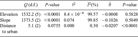
Table 1, supported by Table S1, shows the diverse nature of the studies considered in this review, highlighting the difficulty of obtaining sets of homogeneous model cases to perform a meta-analysis. The synthesis proved difficult because of non-equivalence of the metrics and units of the estimators and outcomes across studies, the estimation of very diverse models, and the lack of information in study reports. In order to obtain comparable models, we started by selecting the most commonly used techniques in the short term and long-term logistic regression and Poisson model groups with the same or similar prediction unit size. For each model, we listed its parameters (coefficients), value, standard error or P-value, prediction unit size (base) and number of observations used in adjusting the model. There were not enough comparable models in the short term group, or Poisson long-term group. Among the logistic regression models for long-term planning, we could only perform a meta-analysis for some of the regression coefficients (variables). We considered three regression coefficients using the same metrics and measurement units – elevation (m), slope (%) and distance to urban areas (km) – to perform three distinct meta-analyses with 6, 3 and 3 studies respectively (see Table 4). It should be noted that, within the three sets of studies, we had a large variability in the coefficient values and standard errors, thereby suggesting the presence of heterogeneity in these meta-analysis approaches.

|
We used random-effect meta-analyses (Whitehead 2002; Borenstein et al. 2009) rather than fixed-effect models because we envisaged having uncontrolled between-studies variation as well as the possibility of being able to generalise our results to other statistically similar populations. Thus, we expected to estimate a particular coefficient for each study  , and assumed that each of these values were random realisations of a common unknown coefficient θ. We also computed a measure of heterogeneity for each meta-analysis to assess the validity of our assumption (Borenstein et al. 2009). In particular, for each meta-analysis we considered the significance of the statistic Q (a Q-test) (Whitehead 2002), and we used the I2 statistic as a quantitative measure of true heterogeneity or between-studies variability (Borenstein et al. 2009). Moreover, we considered a restricted maximum likelihood estimator for between-studies variability
  , since it is approximately unbiased and quite efficient (Viechtbauer 2005).
All the meta-analyses were computed using the metafor statistical package (Viechtbauer 2010) for the R statistical environment (R Foundation for Statistical Computing, Vienna, Austria, see http://www.r-project.org, accessed 3 February 2017).
Table 5 shows the results of the Q-test, the values of  and
and  , and the estimated coefficient
  for the three random-effect meta-analyses. This highlights that, for two meta-analyses (elevation and slope), we should reject the assumption of homogeneity and accept the presence of uncontrolled between-studies variability, although, for the other meta-analysis (distance to urban areas), we can assume homogeneity. Despite this result, we have also assumed a random-effect approach for this variable (distance to urban areas) because this result in a more conservative test and the outcomes of both approaches were, in any case, virtually the same. Moreover, only the resulting estimated coefficient value for the distance to urban areas meta-analysis was significant and larger than zero; estimated coefficients for elevation and slope were not significant. A particular problem when evaluating these results is the small number of studies per meta-analysis, and the high variability between studies in terms of coefficient values and standard error, which make the evaluation of these results difficult and their generalisation somewhat limited. However, the results for distance to urban areas (km) are a promising example of the potential that meta-analysis has, though more cooperation for harmonisation in models, temporal range, predictive units, variables and metrics is needed among researchers in the field before a global characterisation of fire occurrence is possible.
|
 (between-studies variability) and the statistic
  (proportion of between-studies variability with respect to total variability), the estimated effect-size
  , and corresponding P-value for the three random-effect meta-analyses
Conclusions and recommendations
The reasonably large quantity of HCF occurrence models published (181 models in 152 published documents) indicates this fire science topic has reached a good level of development, especially in Europe and North America. In recent years, the People’s Republic of China has become the country with the second largest number of studies, behind Spain. The most active world fire areas (Africa and Latin America) still require modelling efforts. We found that few studies have focused on these most active fire regions largely ignored by research (Chuvieco et al. 2008; Krawchuk et al. 2009; Knorr et al. 2014; Bedia et al. 2015), where wildfire databases are not even available (FAO 2010). Improving global wildfire databases in terms of fire location and causes of ignition is essential to have a global diagnosis of HCF occurrence around the world. Remote sensing can be a valuable tool in fire data acquisition when field-collected fire records are unavailable, though these sources are not free from limitations linked to technical thresholds. Remote sensing cannot provide information on causality as this requires field investigation, but reducing the high rates of unknown cause in fire registries in order to build models focused on specific causes should be a global fire management goal, with potential for more efficient risk mitigation.
Once the models are developed, links to management need to be strengthened, and specific capacities demonstrated. For example, fire suppression resources are often challenged by simultaneous occurrences of fires (Molina-Terrén and Cardil 2015), but daily fire load can be predicted in advance by fire occurrence models, identifying areas where fires are most likely to occur. The explanatory and predictive capacity of fire occurrence models is not yet widely used in management applications, though some fire management systems have made provisions for their use (Chuvieco et al. 2010), partly because comprehensive national risk assessment frameworks are lacking in most fire-affected countries, if not all. Demands for strategic planning and operational applications will continue to increase, as paradigms are changing to allow for managed or prescribed fire (let-burn policies), budgets are increasingly constrained, wildland–urban interfaces are expanding and climate change introduces uncertainties.
What are the most appropriate variables and methods for applications in forest and fire management and civil protection? There are many good choices available. The first wildfire occurrence models were simple and did not predict very well, then, logistic regression models were introduced and became commonly used, and, over the years, they have been joined by more complex methodologies, such as CARTs, ANNs, SVMs, GAMs and other parametric and non-parametric models, all with good accuracies, but little managerial use. Model complexity and model perception as a black box (e.g. for ANN) with lack of adequate technical transference may partly explain this lack of use of some novel techniques. Models based on point pattern analysis hold the greatest potential for the future in terms of resolution, but they are not yet as developed and technically accessible as traditional statistical models, which in turn have to be controlled for multicollinearity problems.
HCF occurrence models include many different predictors, according to model goals that set different time ranges: they are either operational (short-term, mainly daily time ranges) or aim to influence planning (long-term, mainly a period of several years). Weather-related variables drive the daily operational models, but some fire danger rating indices have proved optimal for integrating weather conditions conducive to fires, particularly FFMC and FWI, present in the majority of studies conducted. Over the long-term, HCFs tend to be associated with accessible and populated areas, close to houses and their socioeconomic activities (both productive and leisure locations), interfaces and fragmented landscapes.
Models and predictors, though, vary locally and heavily depend on causative agents, so more studies stratified by cause or fire-prone activities are a research need, since they are scarce.
A quantitative summary of HCF models results through a meta-analysis reveals this diversity of techniques, variables and units used, and spatiotemporal dimensions (time frame and prediction spatial units). However, original databases are not available in published work. Data availability and some normalisation in terms of the spatial units and variables used, as well as their metrics and units, would improve comparability among studies and meta-analysis potential.
In closing, future research into fire occurrence should seek deeper knowledge on causality, improving global wildfire databases, novel model development, some normalisation in techniques, metrics and units, and better integration of fire occurrence within risk assessment frameworks for improved transference to management. Fire occurrence models may be useful inputs to managerial applications in fire prevention, forest and fuel treatments, media campaigns, planning for risk reduction and damage mitigation, supporting decisions or strategies and policies for general fire, forest or land management, fire suppression efficiency, deployment optimisation and pre-suppression planning, optimisation of human resources and budgets, and, lastly, for modelling climate change effects on vegetation covers and fire regimes.
Conflicts of interest
The authors declare that they have no conflicts of interest.
Acknowledgements
We acknowledge with gratitude the useful contributions of the three anonymous reviewers and the Associate Editor of this review paper. This research article received a grant for its linguistic revision from the Language Institute of the University of Lleida in 2017.
References
Abt KL, Butry DT, Prestemon JP, Scranton S (2015) Effect of fire prevention programs on accidental and incendiary wildfires on tribal lands in the United States. International Journal of Wildland Fire 24, 749–762.| Effect of fire prevention programs on accidental and incendiary wildfires on tribal lands in the United States.Crossref | GoogleScholarGoogle Scholar |
Ager AA, Preisler HK, Arca B, Spano D, Salis M (2014) Wildfire risk estimation in the Mediterranean area. Environmetrics 25, 384–396.
| Wildfire risk estimation in the Mediterranean area.Crossref | GoogleScholarGoogle Scholar |
Albertson K, Aylen J, Cavan G, McMorrow J (2009) Forecasting the outbreak of moorland wildfires in the English Peak District. Journal of Environmental Management 90, 2642–2651.
| Forecasting the outbreak of moorland wildfires in the English Peak District.Crossref | GoogleScholarGoogle Scholar | 1:CAS:528:DC%2BD1MXos1ektbc%3D&md5=4eb9ce23328849c1e5040a9ddccb6e40CAS |
Alcasena FJ, Salis M, Nauslar NJ, Aguinaga AE, Vega-García C (2016) Quantifying economic losses from wildfires in black pine afforestations of northern Spain. Forest Policy and Economics 73, 153–167.
| Quantifying economic losses from wildfires in black pine afforestations of northern Spain.Crossref | GoogleScholarGoogle Scholar |
Alonso-Betanzos A, Fontenla-Romero O, Guijarro-Berdiñas B, Hernández-Pereira E, Inmaculada Paz Andrade M, Jiménez E, Luis Legido Soto J, Carballas T (2003) An intelligent system for forest fire risk prediction and fire fighting management in Galicia. Expert Systems with Applications 25, 545–554.
| An intelligent system for forest fire risk prediction and fire fighting management in Galicia.Crossref | GoogleScholarGoogle Scholar |
Altobellis AT (1983) A survey of rural population density and forest fire occurrence in the south, 1956–1970. USDA Forest Service, Southern Forest Experiment Station, Research Note SO-294. (New Orleans, LA, USA)
Amatulli G, Rodrigues MJ, Trombetti M, Lovreglio R (2006) Assessing long-term fire risk at local scale by means of decision tree technique. Journal of Geophysical Research. Biogeosciences 111, G04S05
| Assessing long-term fire risk at local scale by means of decision tree technique.Crossref | GoogleScholarGoogle Scholar |
Ancog RC, Florece LM, Nicopior OB (2016) Fire occurrence and fire mitigation strategies in a grassland reforestation area in the Philippines. Forest Policy and Economics 64, 35–45.
| Fire occurrence and fire mitigation strategies in a grassland reforestation area in the Philippines.Crossref | GoogleScholarGoogle Scholar |
Andrews PL, Loftsgaarden DO, Bradshaw LS (2003) Evaluation of fire danger rating indexes using logistic regression and percentile analysis. International Journal of Wildland Fire 12, 213–226.
| Evaluation of fire danger rating indexes using logistic regression and percentile analysis.Crossref | GoogleScholarGoogle Scholar |
Argañaraz JP, Gavier Pizarro G, Zak M, Landi MA, Bellis LM (2015) Human and biophysical drivers of fires in semiarid Chaco Mountains of central Argentina. The Science of the Total Environment 520, 1–12.
| Human and biophysical drivers of fires in semiarid Chaco Mountains of central Argentina.Crossref | GoogleScholarGoogle Scholar |
Arndt N, Vacik H, Koch V, Arpaci A, Gossow H (2013) Modeling human-caused forest fire ignition for assessing forest fire danger in Austria. iForest 6, 315–325.
| Modeling human-caused forest fire ignition for assessing forest fire danger in Austria.Crossref | GoogleScholarGoogle Scholar |
Avila-Flores D, Pompa-Garcia M, Antonio-Nemiga X, Rodriguez-Trejo DA, Vargas-Perez E, Santillan-Perez J (2010) Driving factors for forest fire occurrence in Durango State of Mexico: a geospatial perspective. Chinese Geographical Science 20, 491–497.
| Driving factors for forest fire occurrence in Durango State of Mexico: a geospatial perspective.Crossref | GoogleScholarGoogle Scholar |
Badia A, Serra P, Modugno S (2011) Identifying dynamics of fire ignition probabilities in two representative Mediterranean wildland–urban interface areas. Applied Geography 31, 930–940.
| Identifying dynamics of fire ignition probabilities in two representative Mediterranean wildland–urban interface areas.Crossref | GoogleScholarGoogle Scholar |
Badia-Perpinyà A, Pallares-Barbera M (2006) Spatial distribution of ignitions in Mediterranean periurban and rural areas: the case of Catalonia. International Journal of Wildland Fire 15, 187–196.
| Spatial distribution of ignitions in Mediterranean periurban and rural areas: the case of Catalonia.Crossref | GoogleScholarGoogle Scholar |
Bar Massada A, Syphard AD, Stewart SI, Radeloff VC (2013) Wildfire ignition-distribution modelling: a comparative study in the Huron–Manistee National Forest, Michigan, USA. International Journal of Wildland Fire 22, 174–183.
| Wildfire ignition-distribution modelling: a comparative study in the Huron–Manistee National Forest, Michigan, USA.Crossref | GoogleScholarGoogle Scholar |
Barreal J, Loureiro ML (2015) Modelling spatial patterns and temporal trends of wildfires in Galicia (NW Spain). Forest Systems 24, e022
| Modelling spatial patterns and temporal trends of wildfires in Galicia (NW Spain).Crossref | GoogleScholarGoogle Scholar |
Bashari H, Naghipour AA, Khajeddin SJ, Sangoony H, Tahmasebi P (2016) Risk of fire occurrence in arid and semi-arid ecosystems of Iran: an investigation using Bayesian belief networks. Environmental Monitoring and Assessment 188, art531
| Risk of fire occurrence in arid and semi-arid ecosystems of Iran: an investigation using Bayesian belief networks.Crossref | GoogleScholarGoogle Scholar |
Beccari A, Borgoni R, Cazzuli O, Grimaldelli R (2015) Use and performance of the Forest Fire Weather Index to model the risk of wildfire occurrence in the Alpine region. Environment and Planning. B, Planning & Design 0, 1–19.
| Use and performance of the Forest Fire Weather Index to model the risk of wildfire occurrence in the Alpine region.Crossref | GoogleScholarGoogle Scholar | 1:CAS:528:DC%2BC28Xjt1Glu7g%3D&md5=f3b1f1e39ddebd49019304158adc6c9bCAS |
Bedia J, Herrera S, Gutiérrez JM (2014) Assessing the predictability of fire occurrence and area burned across phytoclimatic regions in Spain. Natural Hazards and Earth System Sciences 14, 53–66.
| Assessing the predictability of fire occurrence and area burned across phytoclimatic regions in Spain.Crossref | GoogleScholarGoogle Scholar |
Bedia J, Herrera S, Gutiérrez JM, Benali A, Brands S, Mota B, Moreno JM (2015) Global patterns in the sensitivity of burned area to fire-weather: implications for climate change. Agricultural and Forest Meteorology 214–215, 369–379.
| Global patterns in the sensitivity of burned area to fire-weather: implications for climate change.Crossref | GoogleScholarGoogle Scholar |
Borenstein M, Hedges LV, Higgins JPT, Rothstein HR (2009) ‘Introduction to Meta-Analysis.’ (Wiley: Padstow, UK)
Boubeta M, Lombardía MJ, Marey-Pérez MF, Morales D (2015) Prediction of forest fires occurrences with area-level Poisson mixed models. Journal of Environmental Management 154, 151–158.
| Prediction of forest fires occurrences with area-level Poisson mixed models.Crossref | GoogleScholarGoogle Scholar |
Boulanger Y, Gauthier S, Burton PJ, Vaillancourt MA (2012) An alternative fire regime zonation for Canada. International Journal of Wildland Fire 21, 1052–1064.
| An alternative fire regime zonation for Canada.Crossref | GoogleScholarGoogle Scholar |
Boulanger Y, Gauthier S, Burton PJ (2014) A refinement of models projecting future Canadian fire regimes using homogeneous fire regime zones. Canadian Journal of Forest Research 44, 365–376.
| A refinement of models projecting future Canadian fire regimes using homogeneous fire regime zones.Crossref | GoogleScholarGoogle Scholar | 1:CAS:528:DC%2BC2cXjtlyltr4%3D&md5=dffa9a7a1c09babe8104f61d9bc80a96CAS |
Bradshaw LS, Deeming JE, Burgan RE, Cohen JD (1983) The 1978 National Fire-Danger Rating System: Technical Documentation. USDA Forest Service, Intermountain Forest and Range Research Station, General Technical Report INT-169. (Ogden, UT, USA)
Bradstock RA, Cohn JS, Gill AM, Bedward M, Lucas C (2009) Prediction of the probability of large fires in the Sydney region of south-eastern Australia using fire weather. International Journal of Wildland Fire 18, 932–943.
| Prediction of the probability of large fires in the Sydney region of south-eastern Australia using fire weather.Crossref | GoogleScholarGoogle Scholar |
Bruce D (1963) How many fires? Fire Control Notes 24, 45–50. Available at https://www.fs.fed.us/fire/fmt/fmt_pdfs/024_02.pdf [Verified 7 February 2016]
Cardille JA, Ventura SJ (2001) Occurrence of wildfire in the northern Great Lakes Region: effects of land cover and land ownership assessed at multiple scales. International Journal of Wildland Fire 10, 145–154.
| Occurrence of wildfire in the northern Great Lakes Region: effects of land cover and land ownership assessed at multiple scales.Crossref | GoogleScholarGoogle Scholar |
Cardille JA, Ventura SJ, Turner MG (2001) Environmental and social factors influencing wildfires in the Upper Midwest, United States. Ecological Applications 11, 111–127.
| Environmental and social factors influencing wildfires in the Upper Midwest, United States.Crossref | GoogleScholarGoogle Scholar |
Carvalho A, Flannigan MD, Logan K, Miranda AI, Borrego C (2008) Fire activity in Portugal and its relationship to weather and the Canadian Fire Weather Index System. International Journal of Wildland Fire 17, 328–338.
| Fire activity in Portugal and its relationship to weather and the Canadian Fire Weather Index System.Crossref | GoogleScholarGoogle Scholar |
Carvalho A, Flannigan MD, Logan KA, Gowman LM, Miranda AI, Borrego C (2010) The impact of spatial resolution on area burned and fire occurrence projections in Portugal under climate change. Climatic Change 98, 177–197.
| The impact of spatial resolution on area burned and fire occurrence projections in Portugal under climate change.Crossref | GoogleScholarGoogle Scholar | 1:CAS:528:DC%2BD1MXhsFyksbzK&md5=73e36ef34790ca975427e0c4edcde814CAS |
Catry FX, Rego FC, Bação FL, Moreira F (2009) Modeling and mapping wildfire ignition risk in Portugal. International Journal of Wildland Fire 18, 921–931.
| Modeling and mapping wildfire ignition risk in Portugal.Crossref | GoogleScholarGoogle Scholar |
Chang Y, Zhu Z, Bu R, Chen H, Feng Y, Li Y, Hu Y, Wang Z (2013) Predicting fire occurrence patterns with logistic regression in Heilongjiang Province, China. Landscape Ecology 28, 1989–2004.
| Predicting fire occurrence patterns with logistic regression in Heilongjiang Province, China.Crossref | GoogleScholarGoogle Scholar |
Chas-Amil ML, Touza J, Prestemon JP (2010) Spatial distribution of human-caused forest fires in Galicia (NW Spain). Ecology & Environment 137, 247–258.
| Spatial distribution of human-caused forest fires in Galicia (NW Spain).Crossref | GoogleScholarGoogle Scholar |
Chas-Amil ML, Prestemon JP, Mcclean CJ, Touza J (2015) Human-ignited wild fire patterns and responses to policy shifts. Applied Geography 56, 164–176.
| Human-ignited wild fire patterns and responses to policy shifts.Crossref | GoogleScholarGoogle Scholar |
Chou YH (1992) Management of wildfires with a geographical information system. International Journal of Geographical Information Systems 6, 123–140.
| Management of wildfires with a geographical information system.Crossref | GoogleScholarGoogle Scholar |
Chuvieco E, Giglio L, Justice C (2008) Global characterization of fire activity: toward defining fire regimes from Earth observation data. Global Change Biology 14, 1488–1502.
| Global characterization of fire activity: toward defining fire regimes from Earth observation data.Crossref | GoogleScholarGoogle Scholar |
Chuvieco E, Aguado I, Yebra M, Nieto H, Salas J, Martín MP, Vilar L, Martínez J, Martín S, Ibarra P, de la Riva J, Baeza J, Rodríguez F, Molina JR, Herrera MA, Zamora R (2010) Development of a framework for fire risk assessment using remote sensing and geographic information system technologies. Ecological Modelling 221, 46–58.
| Development of a framework for fire risk assessment using remote sensing and geographic information system technologies.Crossref | GoogleScholarGoogle Scholar |
Chuvieco E, Aguado I, Jurdao S, Pettinari ML, Yebra M, Salas J, Hantson S, de la Riva J, Ibarra P, Rodrigues M, Echeverría M, Azqueta D, Román MV, Bastarrika A, Martínez S, Recondo C, Zapico E, Martínez-Vega FJ (2014) Integrating geospatial information into fire risk assessment. International Journal of Wildland Fire 23, 606-619
| Integrating geospatial information into fire risk assessment.Crossref | GoogleScholarGoogle Scholar |
Collins KM, Price OF, Penman TD (2015) Spatial patterns of wildfire ignitions in south-eastern Australia. International Journal of Wildland Fire 24, 1098–1108.
| Spatial patterns of wildfire ignitions in south-eastern Australia.Crossref | GoogleScholarGoogle Scholar |
Costafreda-Aumedes S, Garcia-Martin A, Vega-Garcia C (2013) The relationship between landscape patterns and human-caused fire occurrence in Spain. Forest Systems 22, 71–81.
| The relationship between landscape patterns and human-caused fire occurrence in Spain.Crossref | GoogleScholarGoogle Scholar |
Costafreda-Aumedes S, Cardil A, Molina D, Daniel S, Mavsar R, Vega-Garcia C (2016a) Analysis of factors influencing deployment of fire suppression resources in Spain using artificial neural networks. iForest – Biogeosciences and Forestry 9, 138–145.
| Analysis of factors influencing deployment of fire suppression resources in Spain using artificial neural networks.Crossref | GoogleScholarGoogle Scholar |
Costafreda-Aumedes S, Comas C, Vega-Garcia C (2016b) Spatio-temporal configurations of human-caused fires in Spain through point patterns. Forests 7, art185
| Spatio-temporal configurations of human-caused fires in Spain through point patterns.Crossref | GoogleScholarGoogle Scholar |
Crosby JS (1954) Fire occurrence can be predicted. USDA Forest Service, Central States Forest. Experiment Station, Technical Paper 143. (Columbus, OH, USA)
Cunningham AA, Martell DL (1973) A stochastic model for the occurrence of man-caused forest fires. Canadian Journal of Forest Research 3, 282–287.
| A stochastic model for the occurrence of man-caused forest fires.Crossref | GoogleScholarGoogle Scholar |
DeWilde L, Chapin FS (2006) Human impacts on the fire regime of interior Alaska: Interactions among fuels, ignition sources, and fire suppression. Ecosystems 9, 1342–1353.
| Human impacts on the fire regime of interior Alaska: Interactions among fuels, ignition sources, and fire suppression.Crossref | GoogleScholarGoogle Scholar |
Dickson BG, Prather JW, Xu Y, Hampton HM, Aumack EN, Sisk TD (2006) Mapping the probability of large fire occurrence in northern Arizona, USA. Landscape Ecology 21, 747–761.
| Mapping the probability of large fire occurrence in northern Arizona, USA.Crossref | GoogleScholarGoogle Scholar |
Dimitrakopoulos AP, Bemmerzouk AM, Mitsopoulos ID (2011) Evaluation of the Canadian fire weather index system in an eastern Mediterranean environment. Meteorological Applications 18, 83–93.
| Evaluation of the Canadian fire weather index system in an eastern Mediterranean environment.Crossref | GoogleScholarGoogle Scholar |
Dlamini WM (2010) A Bayesian belief network analysis of factors influencing wildfire occurrence in Swaziland. Environmental Modelling & Software 25, 199–208.
| A Bayesian belief network analysis of factors influencing wildfire occurrence in Swaziland.Crossref | GoogleScholarGoogle Scholar |
Dondo Bühler M, de Torres Curth M, Garibaldi LA (2013) Demography and socioeconomic vulnerability influence fire occurrence in Bariloche (Argentina). Landscape and Urban Planning 110, 64–73.
| Demography and socioeconomic vulnerability influence fire occurrence in Bariloche (Argentina).Crossref | GoogleScholarGoogle Scholar |
Donoghue LR, Main WA (1985) Some factors influencing wildfire occurrence and measurement of fire prevention effectiveness. Journal of Environmental Management 20, 87–96.
Donoghue LR, Simard AJ, Main WA (1987) Determining the economic relationship between law enforcement activities and arson wildfires: a feasibility study in Arkansas. Journal of Environmental Management 25, 377–393.
Drever CR, Bergeron Y, Drever MC, Flannigan M, Logan T, Messier C (2009) Effects of climate on occurrence and size of large fires in a northern hardwood landscape: Historical trends, forecasts, and implications for climate change in Témiscamingue, Québec. Applied Vegetation Science 12, 261–272.
| Effects of climate on occurrence and size of large fires in a northern hardwood landscape: Historical trends, forecasts, and implications for climate change in Témiscamingue, Québec.Crossref | GoogleScholarGoogle Scholar |
Duane A, Piqué M, Castellnou M, Brotons L (2015) Predictive modelling of fire occurrences from different fire spread patterns in Mediterranean landscapes. International Journal of Wildland Fire 24, 407–418.
| Predictive modelling of fire occurrences from different fire spread patterns in Mediterranean landscapes.Crossref | GoogleScholarGoogle Scholar |
European Commission (2015) Minutes of the 34th DG ENV and DG JRC meeting of the European Commission expert group on forest fires, 16–17 March 2015, Barcelona, Spain. Available at http://ec.europa.eu/transparency/regexpert/index.cfm?do=groupDetail.groupDetailPDF&groupID=416 [Verified 24 November 2017]
Faivre N, Jin Y, Goulden ML, Randerson JT (2014) Controls on the spatial pattern of wildfire ignitions in Southern California. International Journal of Wildland Fire 23, 799–811.
| Controls on the spatial pattern of wildfire ignitions in Southern California.Crossref | GoogleScholarGoogle Scholar |
Finney MA (2005) The challenge of quantitative risk analysis for wildland fire. Forest Ecology and Management 211, 97–108.
| The challenge of quantitative risk analysis for wildland fire.Crossref | GoogleScholarGoogle Scholar |
FAO (2007) Fire management global assessment 2006. A thematic study prepared in the framework of the Global Forest Resources Assessment 2005. Food and Agriculture Organization of the United Nations, Forestry Paper 151. (Rome, Italy)
FAO (2010) Global Forest Resources Assessment 2010 – Main report. Food and Agriculture Organization of the United Nations, Forestry Paper 163. (Rome, Italy)
FAO (2011) Wildfire Prevention in the Mediterranean. A key issue to reduce the increasing risks of Mediterranean wildfires in the context of climate change. Food and Agriculture Organization of the United Nations, Position paper. Second Mediterranean Forest Week. (Avignon, France)
FAO (2005) Wildland Fire Management Terminology. Food and Agriculture Organization of the United Nations, Forestry Paper 70. (Rome, Italy)
Fuentes-Santos I, Marey-Pérez MF, González-Manteiga W (2013) Forest fire spatial pattern analysis in Galicia (NW Spain). Journal of Environmental Management 128, 30–42.
| Forest fire spatial pattern analysis in Galicia (NW Spain).Crossref | GoogleScholarGoogle Scholar | 1:STN:280:DC%2BC3snnslCqsA%3D%3D&md5=4b30ae57c155d3ec4113be44a7f4d16aCAS |
Gallardo M, Gómez I, Vilar L, Martínez-Vega J, Martín MP (2016) Impacts of future land use/land cover on wildfire occurrence in the Madrid region (Spain). Regional Environmental Change 16, 1047–1061.
| Impacts of future land use/land cover on wildfire occurrence in the Madrid region (Spain).Crossref | GoogleScholarGoogle Scholar |
Ganteaume A, Camia A, Jappiot M, San-Miguel-Ayanz J, Long-Fournel M, Lampin C (2013) A review of the main driving factors of forest fire ignition over Europe. Environmental Management 51, 651–662.
| A review of the main driving factors of forest fire ignition over Europe.Crossref | GoogleScholarGoogle Scholar |
García Diez EL, Soriano LR, De Pablo Dávila F, Garcia Diez A (1994) An objective forecasting model for the daily outbreak of forest fires based on meteorological considerations. Journal of Applied Meteorology 33, 519–526.
| An objective forecasting model for the daily outbreak of forest fires based on meteorological considerations.Crossref | GoogleScholarGoogle Scholar |
García Diez EL, Rivas Soriano L, de Pablo F, García Diez A (1999) Prediction of the daily number of forest fires. International Journal of Wildland Fire 9, 207–211.
| Prediction of the daily number of forest fires.Crossref | GoogleScholarGoogle Scholar |
Garcia-Gonzalo J, Zubizarreta-Gerendiain A, Ricardo A, Marques S, Botequim B, Borges JG, Oliveira MM, Tomé M, Pereira JMC (2012) Modelling wildfire risk in pure and mixed forest stands in Portugal. Allgemeine Forst- und Jagdzeitung 183, 238–248.
Giglio L (2010) MODIS Collection 5 Active Fire Product User’s Guide Version 2.4. Technical Report, University of Maryland, MD, USA. Available at http://modis-fire.umd.edu/products.asp [Verified 30 June 2017]
Giglio L, Descloitres J, Justice CO, Kaufman YJ (2003) An Enhanced Contextual Fire Detection Algorithm for MODIS. Remote Sensing of Environment 87, 273–282.
| An Enhanced Contextual Fire Detection Algorithm for MODIS.Crossref | GoogleScholarGoogle Scholar |
Giglio L, Loboda T, Roy DP, Quayle B, Justice CO (2009) An active-fire based burned area mapping algorithm for the MODIS sensor. Remote Sensing of Environment 113, 408–420.
| An active-fire based burned area mapping algorithm for the MODIS sensor.Crossref | GoogleScholarGoogle Scholar |
Gonzalez-Olabarria JR, Mola-Yudego B, Pukkala T, Palahi M (2011) Using multiscale spatial analysis to assess fire ignition density in Catalonia, Spain. Annals of Forest Science 68, 861–871.
| Using multiscale spatial analysis to assess fire ignition density in Catalonia, Spain.Crossref | GoogleScholarGoogle Scholar |
González-Olabarria JR, Mola-Yudego B, Coll L (2015) Different factors for different causes: analysis of the spatial aggregations of fire ignitions in Catalonia (Spain). Risk Analysis 35, 1197–1209.
| Different factors for different causes: analysis of the spatial aggregations of fire ignitions in Catalonia (Spain).Crossref | GoogleScholarGoogle Scholar |
Gralewicz NJ, Nelson TA, Wulder MA (2012a) Spatial and temporal patterns of wildfire ignitions in Canada from 1980 to 2006. International Journal of Wildland Fire 21, 230–242.
| Spatial and temporal patterns of wildfire ignitions in Canada from 1980 to 2006.Crossref | GoogleScholarGoogle Scholar |
Gralewicz NJ, Nelson TA, Wulder MA (2012b) Factors influencing national scale wildfire susceptibility in Canada. Forest Ecology and Management 265, 20–29.
| Factors influencing national scale wildfire susceptibility in Canada.Crossref | GoogleScholarGoogle Scholar |
Guo F, Innes JL, Wang G, Ma X, Sun L, Hu H, Su Z (2015) Historic distribution and driving factors of human-caused fires in the Chinese boreal forest between 1972 and 2005. Journal of Plant Ecology 8, 480–490.
| Historic distribution and driving factors of human-caused fires in the Chinese boreal forest between 1972 and 2005.Crossref | GoogleScholarGoogle Scholar |
Guo F, Su Z, Wang G, Sun L, Lin F, Liu A (2016a) Wildfire ignition in the forests of southeast China: identifying drivers and spatial distribution to predict wildfire likelihood. Applied Geography 66, 12–21.
| Wildfire ignition in the forests of southeast China: identifying drivers and spatial distribution to predict wildfire likelihood.Crossref | GoogleScholarGoogle Scholar |
Guo F, Wang G, Su Z, Liang H, Wang W, Lin F, Liu A (2016b) What drives forest fire in Fujian, China? Evidence from logistic regression and Random Forests. International Journal of Wildland Fire 25, 505–519.
| What drives forest fire in Fujian, China? Evidence from logistic regression and Random Forests.Crossref | GoogleScholarGoogle Scholar |
Guo F, Selvalakshmi S, Lin F, Wang G, Wang W, Su Z, Liu A (2016c) Geospatial information on geographical and human factors improved anthropogenic fire occurrence modeling in the Chinese boreal forest. Canadian Journal of Forest Research 46, 582–594.
| Geospatial information on geographical and human factors improved anthropogenic fire occurrence modeling in the Chinese boreal forest.Crossref | GoogleScholarGoogle Scholar |
Haines DA, Main WA, Johnson VJ (1970) Relation between the U.S. National Fire Danger Rating System spread component and fire activity in the lake States. Research Paper NC-41 US Department of Agriculture, Forest Service, North Central Forest Experiment Station. Available at https://www.fs.usda.gov/treesearch/pubs/10562 [Verified 7 February 2016]
Haines DA, Main WA, Frost JS, Simard AJ (1983) Fire-danger rating and wildfire occurrence in the northeastern United States. Forest Science 29, 679–696.
Hegeman EE, Dickson BG, Zachmann LJ (2014) Probabilistic models of fire occurrence across National Park Service units within the Mojave Desert Network, USA. Landscape Ecology 29, 1587–1600.
| Probabilistic models of fire occurrence across National Park Service units within the Mojave Desert Network, USA.Crossref | GoogleScholarGoogle Scholar |
Henry M, Yool S (2004) Assessing relationships between forest spatial patterns and fire history with fusion of optical and microwave remote sensing. Geocarto International 19, 25–37.
| Assessing relationships between forest spatial patterns and fire history with fusion of optical and microwave remote sensing.Crossref | GoogleScholarGoogle Scholar |
Hu T, Zhou G (2014) Drivers of lightning- and human-caused fire regimes in the Great Xing’an Mountains. Forest Ecology and Management 329, 49–58.
| Drivers of lightning- and human-caused fire regimes in the Great Xing’an Mountains.Crossref | GoogleScholarGoogle Scholar |
Hulley G, Veraverbeke S, Hook S (2014) Remote sensing of environment thermal-based techniques for land cover change detection using a new dynamic MODIS multispectral emissivity product (MOD21). Remote Sensing of Environment 140, 755–765.
| Remote sensing of environment thermal-based techniques for land cover change detection using a new dynamic MODIS multispectral emissivity product (MOD21).Crossref | GoogleScholarGoogle Scholar |
Jiang Y, Zhuang Q, Mandallaz D (2012) Modeling large fire frequency and burned area in Canadian terrestrial ecosystems with Poisson models. Environmental Modeling and Assessment 17, 483–493.
| Modeling large fire frequency and burned area in Canadian terrestrial ecosystems with Poisson models.Crossref | GoogleScholarGoogle Scholar |
Juan P, Mateu J, Saez M (2012) Pinpointing spatio-temporal interactions in wildfire patterns. Stochastic Environmental Research and Risk Assessment 26, 1131–1150.
| Pinpointing spatio-temporal interactions in wildfire patterns.Crossref | GoogleScholarGoogle Scholar |
Kalabokidis KD, Koutsias N, Konstantinidis P, Vasilakos C (2007) Multivariate analysis of landscape wildfire dynamics in a Mediterranean ecosystem of Greece. Area 39, 392–402.
| Multivariate analysis of landscape wildfire dynamics in a Mediterranean ecosystem of Greece.Crossref | GoogleScholarGoogle Scholar |
Karouni A, Daya B, Chauvet P (2014) Applying decision tree algorithm and neural networks to predict forest fires in Lebanon. Journal of Theoretical and Applied Information Technology 63, 282–291.
Keetch JJ, Control F, Byram GM, Physicist P (1968) A drought index for forest fire control – a drought index for forest fire control. USDA Forest Service, Southeastern Forest Experiment Station, Research Paper SE-38. (Asheville, NC, USA)
Knorr W, Kaminski T, Arneth A, Weber U (2014) Impact of human population density on fire frequency at the global scale. Biogeosciences 11, 1085–1102.
| Impact of human population density on fire frequency at the global scale.Crossref | GoogleScholarGoogle Scholar |
Koutsias N, Martínez-Fernández J, Allgöwer B (2010) Do factors causing wildfires vary in space? Evidence from geographically weighted regression. GIScience & Remote Sensing 47, 221–240.
| Do factors causing wildfires vary in space? Evidence from geographically weighted regression.Crossref | GoogleScholarGoogle Scholar |
Krawchuk MA, Moritz MA, Parisien MA, Van Dorn J, Hayhoe K (2009) Global pyrogeography: The current and future distribution of wildfire. PLoS One 4, e5102
| Global pyrogeography: The current and future distribution of wildfire.Crossref | GoogleScholarGoogle Scholar |
Kwak H, Lee W-K, Saborowski J, Lee S-Y, Won M-S, Koo K-S, Lee M-B, Kim S-N (2012) Estimating the spatial pattern of human-caused forest fires using a generalized linear mixed model with spatial autocorrelation in South Korea. International Journal of Geographical Information Science 26, 1589–1602.
| Estimating the spatial pattern of human-caused forest fires using a generalized linear mixed model with spatial autocorrelation in South Korea.Crossref | GoogleScholarGoogle Scholar |
Lee SY, Chae HM, Park GS, Ohga S (2012) Predicting the potential impact of climate change on people-caused forest fire occurrence in South Korea. Journal of the Faculty of Agriculture, Kyushu University 57, 17–25.
Lefort P, Leduc A, Gauthier S, Bergeron Y (2004) Recent fire regime (1945–1998) in the boreal forest of western Quebec. Ecoscience 11, 433–445.
| Recent fire regime (1945–1998) in the boreal forest of western Quebec.Crossref | GoogleScholarGoogle Scholar |
Levi MR, Bestelmeyer BT (2016) Biophysical influences on the spatial distribution of fire in the desert grassland region of the southwestern USA. Landscape Ecology 31, 2079–2095.
| Biophysical influences on the spatial distribution of fire in the desert grassland region of the southwestern USA.Crossref | GoogleScholarGoogle Scholar |
Li X, Zhao G, Yu X, Yu Q (2014) A comparison of forest fire indices for predicting fire risk in contrasting climates in China. Natural Hazards 70, 1339–1356.
| A comparison of forest fire indices for predicting fire risk in contrasting climates in China.Crossref | GoogleScholarGoogle Scholar |
Liu Z, Wimberly MC (2015) Climatic and landscape influences on fire regimes from 1984 to 2010 in the western United States. PLoS ONE 10, e0140839
| Climatic and landscape influences on fire regimes from 1984 to 2010 in the western United States.Crossref | GoogleScholarGoogle Scholar |
Liu D, Zhang Y (2015) Research of regional forest fire prediction method based on multivariate linear regression. International Journal of Smart Home 9, 13–22.
| Research of regional forest fire prediction method based on multivariate linear regression.Crossref | GoogleScholarGoogle Scholar |
Liu Y, Stanturf J, Goodrick S (2010) Trends in global wildfire potential in a changing climate. Forest Ecology and Management 259, 685–697.
Liu Z, Yang J, Chang Y, Weisberg PJ, He HS (2012) Spatial patterns and drivers of fire occurrence and its future trend under climate change in a boreal forest of Northeast China. Global Change Biology 18, 2041–2056.
| Spatial patterns and drivers of fire occurrence and its future trend under climate change in a boreal forest of Northeast China.Crossref | GoogleScholarGoogle Scholar |
Lozano FJ, Suárez-Seoane S, de Luis E (2007) Assessment of several spectral indices derived from multi-temporal Landsat data for fire occurrence probability modelling. Remote Sensing of Environment 107, 533–544.
| Assessment of several spectral indices derived from multi-temporal Landsat data for fire occurrence probability modelling.Crossref | GoogleScholarGoogle Scholar |
Mac Nally R (2000) Regression and model-building in conservation biology, biogeography and ecology : the distinction between – and reconciliation of – ‘predictive’ and ‘explanatory’ models. Biodiversity and Conservation 9, 655–671.
| Regression and model-building in conservation biology, biogeography and ecology : the distinction between – and reconciliation of – ‘predictive’ and ‘explanatory’ models.Crossref | GoogleScholarGoogle Scholar |
Magnussen S, Taylor SW (2012) Prediction of daily lightning- and human-caused fires in British Columbia. International Journal of Wildland Fire 21, 342–356.
| Prediction of daily lightning- and human-caused fires in British Columbia.Crossref | GoogleScholarGoogle Scholar |
MAGRAMA (2015) ‘Los incendios forestales en España.’ (Ministry of Agriculture Food and Environment: Area of Defense Against Forest Fires: Madrid, Spain)
Maingi JK, Henry MC (2007) Factors influencing wildlife occurrence and distribution in eastern Kentucky, USA. International Journal of Wildland Fire 16, 23–33.
| Factors influencing wildlife occurrence and distribution in eastern Kentucky, USA.Crossref | GoogleScholarGoogle Scholar |
Mandallaz D, Ye R (1997) Prediction of forest fires with Poisson models. Canadian Journal of Forest Research 27, 1685–1694.
| Prediction of forest fires with Poisson models.Crossref | GoogleScholarGoogle Scholar |
Mann ML, Batllori E, Moritz MA, Waller EK, Berck P, Flint AL, Flint LE, Dolfi E (2016) Incorporating anthropogenic influences into fire probability models: effects of human activity and climate change on fire activity in California. PLoS 11, e0153589
| Incorporating anthropogenic influences into fire probability models: effects of human activity and climate change on fire activity in California.Crossref | GoogleScholarGoogle Scholar |
Marchal J, Cumming SG, McIntire EJB (2017) Exploiting Poisson additivity to predict fire frequency from maps of fire weather and land cover in boreal forests of Québec, Canada. Ecography 40, 200–209.
| Exploiting Poisson additivity to predict fire frequency from maps of fire weather and land cover in boreal forests of Québec, Canada.Crossref | GoogleScholarGoogle Scholar |
Marques S, Garcia-Gonzalo J, Botequim B, Ricardo A, Borges JG, Tome M, Oliveira MM (2012) Assessing wildfire occurrence probability in Pinus pinaster Ait. stands in Portugal. Forest Systems 21, 111–120.
| Assessing wildfire occurrence probability in Pinus pinaster Ait. stands in Portugal.Crossref | GoogleScholarGoogle Scholar |
Martell DL, Otukol S, Stocks BJ (1987) A logistic model for predicting daily people-caused forest fire occurrence in Ontario. Canadian Journal of Forest Research 17, 394–401.
| A logistic model for predicting daily people-caused forest fire occurrence in Ontario.Crossref | GoogleScholarGoogle Scholar |
Martell DL, Bevilacqua E, Stocks BJ (1989) Modelling seasonal variation in daily people-caused forest fire occurrence in Ontario. Canadian Journal of Forest Research 19, 1555–1563.
| Modelling seasonal variation in daily people-caused forest fire occurrence in Ontario.Crossref | GoogleScholarGoogle Scholar |
Martínez J, Vega-Garcia C, Chuvieco E (2009) Human-caused wildfire risk rating for prevention planning in Spain. Journal of Environmental Management 90, 1241–1252.
| Human-caused wildfire risk rating for prevention planning in Spain.Crossref | GoogleScholarGoogle Scholar |
Martínez-Fernández J, Chuvieco E, Koutsias N (2013) Modelling long-term fire occurrence factors in Spain by accounting for local variations with geographically weighted regression. Natural Hazards and Earth System Sciences 13, 311–327.
| Modelling long-term fire occurrence factors in Spain by accounting for local variations with geographically weighted regression.Crossref | GoogleScholarGoogle Scholar |
McArthur AG (1967) Fire behaviour in eucalypt forests. Australian Forestry and Timber Bureau, Leaflet 107. (Canberra, ACT, Australia)
Mercer DE, Prestemon JP (2005) Comparing production function models for wildfire risk analysis in the wildland–urban interface. Forest Policy and Economics 7, 782–795.
| Comparing production function models for wildfire risk analysis in the wildland–urban interface.Crossref | GoogleScholarGoogle Scholar |
Merrill DF, Alexander ME (1987) ‘Glossary of Forest Fire Management Terms’, 4th edn. (National Research Council of Canada, Canadian Committee on Forest Fire Management: Ottawa, ON, Canada)
Mhawej M, Faour G, Abdallah C, Adjizian-Gerard J (2016) Towards an establishment of a wildfire risk system in a Mediterranean country. Ecological Informatics 32, 167–184.
| Towards an establishment of a wildfire risk system in a Mediterranean country.Crossref | GoogleScholarGoogle Scholar |
Miller C, Ager AA (2013) A review of recent advances in risk analysis for wildfire management. International Journal of Wildland Fire 22, 1–14.
| A review of recent advances in risk analysis for wildfire management.Crossref | GoogleScholarGoogle Scholar |
Miranda BR, Sturtevant BR, Stewart SI, Hammer RB (2012) Spatial and temporal drivers of wildfire occurrence in the context of rural development in northern Wisconsin, USA. International Journal of Wildland Fire 21, 141–154.
| Spatial and temporal drivers of wildfire occurrence in the context of rural development in northern Wisconsin, USA.Crossref | GoogleScholarGoogle Scholar |
Mishra NB, Mainali KP, Crews KA (2016) Modelling spatiotemporal variability in fires in semiarid savannas: a satellite-based assessment around Africa’s largest protected area. International Journal of Wildland Fire 25, 730–741.
| Modelling spatiotemporal variability in fires in semiarid savannas: a satellite-based assessment around Africa’s largest protected area.Crossref | GoogleScholarGoogle Scholar |
Modugno S, Balzter H, Cole B, Borrelli P (2016) Mapping regional patterns of large forest fires in wildland–urban interface areas in Europe. Journal of Environmental Management 172, 112–126.
| Mapping regional patterns of large forest fires in wildland–urban interface areas in Europe.Crossref | GoogleScholarGoogle Scholar |
Molina-Terrén DM, Cardil A (2015) Temperature determining larger wildland fires in NE Spain. Theoretical and Applied Climatology 125, 295–302.
| Temperature determining larger wildland fires in NE Spain.Crossref | GoogleScholarGoogle Scholar |
Morgera E, Cirelli MT (2009) Forest fires and the law – a guide for national drafters based on the fire management voluntary guidelines. Food and Agricultural Organization of the United Nations. (Rome, Italy)
Moritz MA, Parisien M-A, Batllori E, Krawchuck MA, van Dorn J, Ganz DJ, Hayhoe K (2012) Climate change and disruptions to global fire activity. Ecosphere 3, 1–22.
Morrison PH (2007) Roads and Wildfires. Pacific Biodiversity Institute. (Winthrop, WA, USA)
Mundo IA, Wiegand T, Kanagaraj R, Kitzberger T (2013) Environmental drivers and spatial dependency in wild fire ignition patterns of northwestern Patagonia. Journal of Environmental Management 123, 77–87.
| Environmental drivers and spatial dependency in wild fire ignition patterns of northwestern Patagonia.Crossref | GoogleScholarGoogle Scholar |
Najafabadi ATP, Gorgani F, Najafabadi MO (2015) Modeling forest fires in Mazandaran Province, Iran. Journal of Forestry Research 26, 851–858.
| Modeling forest fires in Mazandaran Province, Iran.Crossref | GoogleScholarGoogle Scholar |
Narayanaraj G, Wimberly MC (2012) Influences of forest roads on the spatial patterns of human- and lightning-caused wildfire ignitions. Applied Geography 32, 878–888.
| Influences of forest roads on the spatial patterns of human- and lightning-caused wildfire ignitions.Crossref | GoogleScholarGoogle Scholar |
Nunes AN, Lourenço L, Meira ACC (2016) Exploring spatial patterns and drivers of forest fires in Portugal (1980–2014). The Science of the Total Environment 573, 1190–1202.
| Exploring spatial patterns and drivers of forest fires in Portugal (1980–2014).Crossref | GoogleScholarGoogle Scholar | 1:CAS:528:DC%2BC28Xmtlens74%3D&md5=1f6871f14746ef25bf202d1ea1d3c87cCAS |
O’Rourke K (2007) An historical perspective on meta-analysis: dealing quantitatively with varying study results. Journal of the Royal Society of Medicine 100, 579–582.
| An historical perspective on meta-analysis: dealing quantitatively with varying study results.Crossref | GoogleScholarGoogle Scholar |
Oliveira S, Oehler F, San-Miguel-Ayanz J, Camia A, Pereira JMC (2012) Modeling spatial patterns of fire occurrence in Mediterranean Europe using multiple regression and random forest. Forest Ecology and Management 275, 117–129.
| Modeling spatial patterns of fire occurrence in Mediterranean Europe using multiple regression and random forest.Crossref | GoogleScholarGoogle Scholar |
Oliveira S, Pereira JMC, San-Miguel-Ayanz J, Lourenço L (2014) Exploring the spatial patterns of fire density in Southern Europe using Geographically Weighted Regression. Applied Geography 51, 143–157.
| Exploring the spatial patterns of fire density in Southern Europe using Geographically Weighted Regression.Crossref | GoogleScholarGoogle Scholar |
Padilla M, Vega-Garcia C (2011) On the comparative importance of fire danger rating indices and their integration with spatial and temporal variables for predicting daily human-caused fire occurrences in Spain. International Journal of Wildland Fire 20, 46–58.
| On the comparative importance of fire danger rating indices and their integration with spatial and temporal variables for predicting daily human-caused fire occurrences in Spain.Crossref | GoogleScholarGoogle Scholar |
Pan J, Wang W, Li J (2016) Building probabilistic models of fire occurrence and fire risk zoning using logistic regression in Shanxi Province, China. Natural Hazards 81, 1879–1899.
| Building probabilistic models of fire occurrence and fire risk zoning using logistic regression in Shanxi Province, China.Crossref | GoogleScholarGoogle Scholar |
Papakosta P, Straub D (2016) Probabilistic prediction of daily fire occurrence in the Mediterranean with readily available spatio-temporal data. iForest – Biogeosciences and Forestry 9, e1–e9.
| Probabilistic prediction of daily fire occurrence in the Mediterranean with readily available spatio-temporal data.Crossref | GoogleScholarGoogle Scholar |
Parisien M-A, Moritz MA (2009) Environmental controls on the distribution of wildfire at multiple spatial scales. Ecological Monographs 79, 127–154.
| Environmental controls on the distribution of wildfire at multiple spatial scales.Crossref | GoogleScholarGoogle Scholar |
Penman TD, Bradstock RA, Price O (2013) Modelling the determinants of ignition in the Sydney Basin, Australia: implications for future management. International Journal of Wildland Fire 22, 469–478.
| Modelling the determinants of ignition in the Sydney Basin, Australia: implications for future management.Crossref | GoogleScholarGoogle Scholar |
Pew KL, Larsen CPS (2001) GIS analysis of spatial and temporal patterns of human-caused wildfires in the temperate rain forest of Vancouver Island, Canada. Forest Ecology and Management 140, 1–18.
| GIS analysis of spatial and temporal patterns of human-caused wildfires in the temperate rain forest of Vancouver Island, Canada.Crossref | GoogleScholarGoogle Scholar |
Plucinski MP (2012) A review of wildfire occurrence. (Bushfire Cooperative Research Centre: East Melbourne, Vic., Australia)
Plucinski MP (2014) The timing of vegetation fire occurrence in a human landscape. Fire Safety Journal 67, 42–52.
| The timing of vegetation fire occurrence in a human landscape.Crossref | GoogleScholarGoogle Scholar |
Plucinski MP, McCaw WL, Gould JS, Wotton BM (2014) Predicting the number of daily human-caused bushfires to assist suppression planning in south-west Western Australia. International Journal of Wildland Fire 23, 520–531.
| Predicting the number of daily human-caused bushfires to assist suppression planning in south-west Western Australia.Crossref | GoogleScholarGoogle Scholar |
Prasad VK, Badarinath KVS, Eaturu A (2008) Biophysical and anthropogenic controls of forest fires in the Deccan Plateau, India. Journal of Environmental Management 86, 1–13.
| Biophysical and anthropogenic controls of forest fires in the Deccan Plateau, India.Crossref | GoogleScholarGoogle Scholar |
Preisler HK, Westerling AL (2007) Statistical model for forecasting monthly large wildfire events in Western United States. Journal of Applied Meteorology and Climatology 46, 1020–1030.
| Statistical model for forecasting monthly large wildfire events in Western United States.Crossref | GoogleScholarGoogle Scholar |
Preisler HK, Brillinger DR, Burgan RE, Benoit JW (2004) Probability based models for estimation of wildfire risk. International Journal of Wildland Fire 13, 133–142.
| Probability based models for estimation of wildfire risk.Crossref | GoogleScholarGoogle Scholar |
Prestemon JP, Butry DT (2005) Time to burn: modelling wildland arson as an autoregressive crime function. American Journal of Agricultural Economics 87, 756–770.
| Time to burn: modelling wildland arson as an autoregressive crime function.Crossref | GoogleScholarGoogle Scholar |
Price O, Bradstock R (2014) Countervailing effects of urbanization and vegetation extent on fire frequency on the wildland–urban interface: disentangling fuel and ignition effects. Landscape and Urban Planning 130, 81–88.
| Countervailing effects of urbanization and vegetation extent on fire frequency on the wildland–urban interface: disentangling fuel and ignition effects.Crossref | GoogleScholarGoogle Scholar |
Reineking B, Weibel P, Conedera M, Bugmann H (2010) Environmental determinants of lightning- v. human-induced forest fire ignitions differ in a temperate mountain region of Switzerland. International Journal of Wildland Fire 19, 541–557.
| Environmental determinants of lightning- v. human-induced forest fire ignitions differ in a temperate mountain region of Switzerland.Crossref | GoogleScholarGoogle Scholar |
Rodrigues M, de la Riva J (2014) An insight into machine-learning algorithms to model human-caused wildfire occurrence. Environmental Modelling & Software 57, 192–201.
| An insight into machine-learning algorithms to model human-caused wildfire occurrence.Crossref | GoogleScholarGoogle Scholar |
Rodrigues M, de la Riva J, Fotheringham S (2014) Modeling the spatial variation of the explanatory factors of human-caused wildfires in Spain using geographically weighted logistic regression. Applied Geography 48, 52–63.
| Modeling the spatial variation of the explanatory factors of human-caused wildfires in Spain using geographically weighted logistic regression.Crossref | GoogleScholarGoogle Scholar |
Rodrigues M, Jiménez A, de la Riva J (2016) Analysis of recent spatial–temporal evolution of human driving factors of wildfires in Spain. Natural Hazards 84, 2049–2070.
| Analysis of recent spatial–temporal evolution of human driving factors of wildfires in Spain.Crossref | GoogleScholarGoogle Scholar |
Romero-Calcerrada R, Novillo CJ, Millington JDA, Gomez-Jimenez I (2008) GIS analysis of spatial patterns of human-caused wildfire ignition risk in the SW of Madrid (Central Spain). Landscape Ecology 23, 341–354.
| GIS analysis of spatial patterns of human-caused wildfire ignition risk in the SW of Madrid (Central Spain).Crossref | GoogleScholarGoogle Scholar |
Romero-Calcerrada R, Barrio-Parra F, Millington JDA, Novillo CJ (2010) Spatial modelling of socioeconomic data to understand patterns of human-caused wildfire ignition risk in the SW of Madrid (central Spain). Ecological Modelling 221, 34–45.
| Spatial modelling of socioeconomic data to understand patterns of human-caused wildfire ignition risk in the SW of Madrid (central Spain).Crossref | GoogleScholarGoogle Scholar |
Romme WH (1980) Fire frequency in subalpine forests of Yellowstone National Park. In ‘Proceedings of the Fire History Workshop’. (Eds MA Stockes, JH Dieterich) General Technical Report RM-81, US Department of Agriculture, Forest Service, Rocky Mountain Forest and Range Experiment Station, pp. 27–30. (Tucson, AZ, USA)
Ruiz-Mirazo J, Martínez-Fernández J, Vega-García C (2012) Pastoral wildfires in the Mediterranean: Understanding their linkages to land cover patterns in managed landscapes. Journal of Environmental Management 98, 43–50.
| Pastoral wildfires in the Mediterranean: Understanding their linkages to land cover patterns in managed landscapes.Crossref | GoogleScholarGoogle Scholar |
Sakr GE, Elhajj IH, Mitri G (2011) Efficient forest fire occurrence prediction for developing countries using two weather parameters. Engineering Applications of Artificial Intelligence 24, 888–894.
| Efficient forest fire occurrence prediction for developing countries using two weather parameters.Crossref | GoogleScholarGoogle Scholar |
Schmidt CC, Prins EM, Feltz J (2002) The GOES wildfire automated biomass burning algorithm processing system. Presented at the AGU Spring Meeting, Washington, DC, 28–31 May 2002.
Sebastián-López A, Salvador-Civil R, Gonzalo-Jiménez J, SanMiguel-Ayanz J (2008) Integration of socio-economic and environmental variables for modelling long-term fire danger in Southern Europe. European Journal of Forest Research 127, 149–163.
| Integration of socio-economic and environmental variables for modelling long-term fire danger in Southern Europe.Crossref | GoogleScholarGoogle Scholar |
Serra L, Juan P, Varga D, Mateu J, Saez M (2013) Spatial pattern modelling of wildfires in Catalonia, Spain 2004–2008. Environmental Modelling & Software 40, 235–244.
| Spatial pattern modelling of wildfires in Catalonia, Spain 2004–2008.Crossref | GoogleScholarGoogle Scholar |
Serra L, Saez M, Mateu J, Varga D, Juan P, Díaz-Ávalos C, Rue H (2014) Spatio-temporal log-Gaussian Cox processes for modelling wildfire occurrence: the case of Catalonia, 1994–2008. Environmental and Ecological Statistics 21, 531–563.
| Spatio-temporal log-Gaussian Cox processes for modelling wildfire occurrence: the case of Catalonia, 1994–2008.Crossref | GoogleScholarGoogle Scholar |
Sitanggang IS, Yaakob R, Mustapha N, Ainuddin AN (2013) Predictive models for hotspots occurrence using decision tree algorithms and logistic regression. Journal of Applied Sciences 13, 252–261.
| Predictive models for hotspots occurrence using decision tree algorithms and logistic regression.Crossref | GoogleScholarGoogle Scholar |
Stolle F, Chomitz KM, Lambin EF, Tomich TP (2003) Land use and vegetation fires in Jambi Province, Sumatra, Indonesia. Forest Ecology and Management 179, 277–292.
| Land use and vegetation fires in Jambi Province, Sumatra, Indonesia.Crossref | GoogleScholarGoogle Scholar |
Sturtevant BR, Cleland DT (2007) Human and biophysical factors influencing modern fire disturbance in northern Wisconsin. International Journal of Wildland Fire 16, 398–413.
| Human and biophysical factors influencing modern fire disturbance in northern Wisconsin.Crossref | GoogleScholarGoogle Scholar |
Syphard AD, Keeley JE (2015) Location, timing and extent of wildfire vary by cause of ignition. International Journal of Wildland Fire 24, 37–47.
| Location, timing and extent of wildfire vary by cause of ignition.Crossref | GoogleScholarGoogle Scholar |
Syphard AD, Radeloff VC, Keeley JE, Hawbaker TJ, Clayton MK, Stewart SI, Hammer RB (2007) Human influence on California fire regimes. Ecological Applications 17, 1388–1402.
| Human influence on California fire regimes.Crossref | GoogleScholarGoogle Scholar |
Syphard AD, Radeloff VC, Keuler NS, Taylor RS, Hawbaker TJ, Stewart SI, Clayton MK (2008) Predicting spatial patterns of fire on a southern California landscape. International Journal of Wildland Fire 17, 602–613.
| Predicting spatial patterns of fire on a southern California landscape.Crossref | GoogleScholarGoogle Scholar |
Syphard AD, Radeloff VC, Hawbaker TJ, Stewart SI (2009) Conservation threats due to human-caused increases in fire frequency in Mediterranean-climate ecosystems. Conservation Biology 23, 758–769.
| Conservation threats due to human-caused increases in fire frequency in Mediterranean-climate ecosystems.Crossref | GoogleScholarGoogle Scholar |
Todd JB, Kourtz PH (1991) Predicting the daily occurrence of people-caused forest fires. Forestry Canada, Petawawa National Forestry Institute, Information Report PI-X-103. (Chalk River, ON, Canada)
Turco M, Llasat M-C, von Hardenberg J, Provenzale A (2014) Climate change impacts on wildfires in a Mediterranean environment. Climatic Change 125, 369–380.
| Climate change impacts on wildfires in a Mediterranean environment.Crossref | GoogleScholarGoogle Scholar |
Vadrevu HP, Eaturu A, Badarinath KVS (2006) Spatial distribution of forest fires and controlling factors in Andhira Pradesh, India, using satellite datasets. Environmental Monitoring and Assessment 123, 75–96.
| Spatial distribution of forest fires and controlling factors in Andhira Pradesh, India, using satellite datasets.Crossref | GoogleScholarGoogle Scholar |
Van Wagner CE (1987) Development and structure of the Canadian Forest Fire Weather Index System, Forestry Technical Report 35. (Chalk River, ON, Canada)
Vasconcelos MJP, Silva S, Tomé M, Alvim M, Cardoso Pereira JM (2001) Spatial Prediction of Fire Ignition Probabilities: Comparing Logistic Regression and Neural Networks. Photogrammetric Engineering and Remote Sensing 67, 73–81.
Vasilakos C, Kalabokidis K, Hatzopoulos J, Matsinos I (2009) Identifying wildland fire ignition factors through sensitivity analysis of a neural network. Natural Hazards 50, 125–143.
| Identifying wildland fire ignition factors through sensitivity analysis of a neural network.Crossref | GoogleScholarGoogle Scholar |
Vega-Garcia C, Woodard PM, Titus SJ, Adamowicz WL, Lee BS (1995) A logit model for predicting the daily occurrence of human caused forest-fires. International Journal of Wildland Fire 5, 101–111.
| A logit model for predicting the daily occurrence of human caused forest-fires.Crossref | GoogleScholarGoogle Scholar |
Vega-Garcia C, Lee BS, Woodard PM, Titus SJ (1996) Applying neural network technology to human-caused wildfire occurrence prediction. AI Applications 10, 9–18.
Venevsky S, Thonicke K, Sitch S, Cramer W (2002) Simulating fire regimes in human-dominated ecosystems: Iberian Peninsula case study. Global Change Biology 8, 984–998.
| Simulating fire regimes in human-dominated ecosystems: Iberian Peninsula case study.Crossref | GoogleScholarGoogle Scholar |
Verdú F, Salas J, Vega-García C (2012) A multivariate analysis of biophysical factors and forest fires in Spain, 1991–2005. International Journal of Wildland Fire 21, 498–509.
| A multivariate analysis of biophysical factors and forest fires in Spain, 1991–2005.Crossref | GoogleScholarGoogle Scholar |
Viechtbauer W (2005) Bias and efficiency of meta-analytic variance estimators in the random-effects model. Journal of Educational and Behavioral Statistics 30, 261–293.
| Bias and efficiency of meta-analytic variance estimators in the random-effects model.Crossref | GoogleScholarGoogle Scholar |
Viechtbauer W (2010) Conducting meta-analyses in R with the metafor package. Journal of Statistical Software 36, 1–47.
| Conducting meta-analyses in R with the metafor package.Crossref | GoogleScholarGoogle Scholar |
Vilar L, Woolford DG, Martell DL, Martin MP (2010) A model for predicting human-caused wildfire occurrence in the region of Madrid, Spain. International Journal of Wildland Fire 19, 325–337.
| A model for predicting human-caused wildfire occurrence in the region of Madrid, Spain.Crossref | GoogleScholarGoogle Scholar |
Vilar L, Camia A, San-Miguel-Ayanz J, Martín MP (2016a) Modeling temporal changes in human-caused wildfires in Mediterranean Europe based on land use–land cover interfaces. Forest Ecology and Management 378, 68–78.
| Modeling temporal changes in human-caused wildfires in Mediterranean Europe based on land use–land cover interfaces.Crossref | GoogleScholarGoogle Scholar |
Vilar L, Gómez I, Martínez-Vega J, Echavarría P, Riaño D, Martín MP (2016b) Multitemporal modelling of socio-economic wildfire drivers in central Spain between the 1980s and the 2000s: comparing generalized linear models to machine learning algorithms. PLoS ONE 11, e0161344
| Multitemporal modelling of socio-economic wildfire drivers in central Spain between the 1980s and the 2000s: comparing generalized linear models to machine learning algorithms.Crossref | GoogleScholarGoogle Scholar |
Vilar del Hoyo L, Martín Isabel MP, Martínez Vega FJ (2011) Logistic regression models for human-caused wildfire risk estimation: analysing the effect of the spatial accuracy in fire occurrence data. European Journal of Forest Research 130, 983–996.
| Logistic regression models for human-caused wildfire risk estimation: analysing the effect of the spatial accuracy in fire occurrence data.Crossref | GoogleScholarGoogle Scholar |
Wan Z, Zhang Y, Zhang Q, Li Z (2002) Validation of the land-surface temperature products retrieved from Terra moderate resolution imaging spectroradiometer data. Remote Sensing of Environment 83, 163–180.
| Validation of the land-surface temperature products retrieved from Terra moderate resolution imaging spectroradiometer data.Crossref | GoogleScholarGoogle Scholar |
West AM, Kumar S, Jarnevich CS (2016) Regional modeling of large wildfires under current and potential future climates in Colorado and Wyoming, USA. Climatic Change 134, 565–577.
| Regional modeling of large wildfires under current and potential future climates in Colorado and Wyoming, USA.Crossref | GoogleScholarGoogle Scholar | 1:CAS:528:DC%2BC2MXhvVOgsL7E&md5=2c40be0316521c9176c31e985b97b925CAS |
WFLC (2017) Challenges and opportunities. The science analysis of the National Cohesive Wildland Fire Management Strategy. (Wildland Fire Leadership Council) Available at https://cohesivefire.nemac.org/challenges-opportunities [Verified 21 June 2017]
Whitehead A (2002) ‘Meta-analysis of controlled clinical trials.’ (Eds S Senn, V Barnett) (Wiley: Chichester, UK)
Wotton BM, Martell DL, Logan KA (2003) Climate change and people-caused forest fire occurrence in Ontario. Climatic Change 60, 275–295.
| Climate change and people-caused forest fire occurrence in Ontario.Crossref | GoogleScholarGoogle Scholar | 1:CAS:528:DC%2BD3sXnvVOrs78%3D&md5=654bcf84d12e9f76983dad0b0e09fa9bCAS |
Wotton BM, Nock CA, Flannigan MD (2010) Forest fire occurrence and climate change in Canada. International Journal of Wildland Fire 19, 253–271.
| Forest fire occurrence and climate change in Canada.Crossref | GoogleScholarGoogle Scholar |
Wu Z, He HS, Yang J, Liu Z, Liang Y (2014) Relative effects of climatic and local factors on fire occurrence in boreal forest landscapes of northeastern China. The Science of the Total Environment 493, 472–480.
| Relative effects of climatic and local factors on fire occurrence in boreal forest landscapes of northeastern China.Crossref | GoogleScholarGoogle Scholar | 1:CAS:528:DC%2BC2cXhtFyktLjI&md5=33d0ba07a069228bbe26000967621ae3CAS |
Xiao Y, Zhang X, Ji P (2015) Modeling forest fire occurrences using count-data mixed models in Qiannan Autonomous Prefecture of Guizhou province in China. PLoS One 10, 1–12.
| Modeling forest fire occurrences using count-data mixed models in Qiannan Autonomous Prefecture of Guizhou province in China.Crossref | GoogleScholarGoogle Scholar |
Yang J, He HS, Shifley SR, Gustafson EJ (2007) Spatial patterns of modern period human-caused fire occurrence in the Missouri Ozark Highlands. Forest Science 53, 1–15.
| Spatial patterns of modern period human-caused fire occurrence in the Missouri Ozark Highlands.Crossref | GoogleScholarGoogle Scholar | 1:CAS:528:DC%2BD2sXit1Gmu78%3D&md5=63659683a418a8ef3f489e8f3c1be319CAS |
Yang J, He HS, Shifley SR (2008) Spatial controls of occurrence and spread of wildfires in the Missouri Ozark highlands. Ecological Applications 18, 1212–1225.
| Spatial controls of occurrence and spread of wildfires in the Missouri Ozark highlands.Crossref | GoogleScholarGoogle Scholar |
Yang J, Weisberg PJ, Dilts TE, Loudermilk EL, Scheller RM, Stanton A, Skinner C (2015) Predicting wildfire occurrence distribution with spatial point process models and its uncertainty assessment: a case study in the Lake Tahoe Basin, USA. International Journal of Wildland Fire 24, 380–390.
| Predicting wildfire occurrence distribution with spatial point process models and its uncertainty assessment: a case study in the Lake Tahoe Basin, USA.Crossref | GoogleScholarGoogle Scholar |
Zhang ZX, Zhang HY, Zhou DW (2010) Using GIS spatial analysis and logistic regression to predict the probabilities of human-caused grassland fires. Journal of Arid Environments 74, 386–393.
| Using GIS spatial analysis and logistic regression to predict the probabilities of human-caused grassland fires.Crossref | GoogleScholarGoogle Scholar |
Zhang H, Han X, Dai S (2013) Fire occurrence probability mapping of northeast China with binary logistic regression model. IEEE Journal of Selected Topics in Applied Earth Observations and Remote Sensing 6, 121–127.
| Fire occurrence probability mapping of northeast China with binary logistic regression model.Crossref | GoogleScholarGoogle Scholar |
Zhang Y, Lim S, Sharples JJ (2016) Modelling spatial patterns of wildfire occurrence in south-eastern Australia. Geomatics, Natural Hazards & Risk 5705, 1–16.
| Modelling spatial patterns of wildfire occurrence in south-eastern Australia.Crossref | GoogleScholarGoogle Scholar |