

Patterns and trends in simultaneous wildfire activity in the United States from 1984 to 2015
Harry Podschwit A C and Alison Cullen B
A College of the Environment Special Programs, Quantitative Ecology and Resource Management (QERM), University of Washington, Seattle, WA 98195, USA.
B Daniel J. Evans School of Public Policy and Governance, University of Washington, Seattle, WA 98195, USA.
C Corresponding author. Email: hpodschwit@gmail.com
International Journal of Wildland Fire 29(12) 1057-1071 https://doi.org/10.1071/WF19150
Submitted: 20 September 2019 Accepted: 22 August 2020 Published: 18 September 2020
Journal Compilation © IAWF 2020 Open Access CC BY-NC
Abstract
The simultaneous occurrence of wildfire can hinder firefighting effectiveness via multiple mechanisms that might explain historical resource demand trends. We validate this hypothesis by using data from the Monitoring Trends in Burn Severity (MTBS) project to determine if simultaneous wildfire occurrence is correlated with preparedness levels and examine potential changes in simultaneous wildfire activity over the 1984–2015 record. We explore patterns that are helpful for predicting simultaneous wildfire, such as seasonal variability in simultaneity, cross-regional correlations and models of simultaneous wildfire occurrence based on dryness and lightning indicators. We show that simultaneous wildfire is at least as correlated with preparedness levels as other burned area measures and identify changes in simultaneous wildfire occurrence within the western and southern United States. Seasonal variation and spatial autocorrelation in simultaneous wildfire occurrence provide evidence of coupling of wildfire activity in portions of the western United States. Best-approximating models of simultaneity suggest that high levels of simultaneous wildfire often coincided with low fuel moisture and high levels of lightning occurrence. Model uncertainty was high in some contexts but, with only a few exceptions, there was strong evidence that the best model should include both a dryness and lightning indicator.
Introduction
The presence of multiple co-occurring fire incidents can reduce firefighting efficiency via multiple mechanisms. For example, this scenario requires dispatchers to distribute staff and equipment across multiple incidents. Effectively distributing resources may require little effort when the number of incidents is low, but it likely becomes increasingly challenging when the number of competing demands are high (Smith and Gonzalez-Caban 1987). In particularly extreme scenarios, demand for firefighting resources can exceed availability, a scenario that requires a sudden increase in resources or the acceptance of unmet demand.
Both the size and number of wildfires will be related to firefighting resource need, but the latter seemingly has several relative benefits as a proxy for suppression effort. Although larger wildfires tend to be more expensive to fight than smaller ones (Calkin et al. 2005), per-hectare suppression costs often decrease with fire size because suppression activities are typically located along the perimeters of wildfires and the perimeter-to-area ratio typically decreases with increasing wildfire size (Smith and Gonzalez-Caban 1987). Therefore, fire perimeter estimates better predict suppression costs than fire number or area (Smith and Gonzalez-Caban 1987) and are used by firefighters to measure suppression effort (Hirsch and Martell 1996). However, as the fractal nature of wildfire burned area makes perimeter measurements challenging (McAlpine and Wotton 1993), simultaneity can serve as an easy-to-calculate substitute. Assuming that fire perimeter length is a determining factor of firefighting effort, a simple geometric analysis demonstrates that – all other factors being held constant – a collection of simultaneous wildfires will require more effort to extinguish than a single comparably sized one (Smith and Gonzalez-Caban 1987). Travel time spent between simultaneous incidents and the associated firefighter fatigue further reduce firefighter effectiveness (Bednar et al. 1990).
Multiple plausible mechanisms link simultaneous wildfire and resource demand, yet burned area is more commonly used to measure fire trends (Doerr and Santín 2016). Among the earliest studies to investigate simultaneity, Bednar et al. (1990) analysed administrative wildfire growth data in the north-western United States and concluded that simultaneous fire tended to increase suppression times. Since then, most studies about simultaneous wildfire occurrence were regarding locations outside the United States. The relationship between meteorological conditions, simultaneity and total burn area has been considered in the Mediterranean (San-Miguel-Ayanz et al. 2013), Sweden (Drobyshev et al. 2012), South America (Román-Cuesta et al. 2014; González et al. 2018), Australia (O’Donnell et al. 2011) and Canada (Magnussen and Taylor 2012). In the United States, Abatzoglou and Kolden (2013) looked at annual burned area to identify synchronous behaviour at broad spatial scales in the western United States. Moreover, Liu and Wimberly (2015) described levels of spatial autocorrelation in fire occurrence in the western United States, and found it to be one of the most highly spatially autocorrelated wildfire characteristic of those they considered. However, little other work has considered the relationship between simultaneous fire occurrence, firefighting and the environment.
Uncertainty associated with this research gap is particularly troubling because wildfire behaviours, and therefore impacts on humans, are changing in ways that are hard to predict. Although detectable increases in wildfire frequency, size and large-fire frequency have been observed in parts of the western United states, particularly in the Southwest (Dennison et al. 2014), burned area has declined globally on average (Andela et al. 2017) and decreases in wildfire activity have been observed in portions of the United States (Syphard et al. 2007). Projections of wildfire activity show similar variability, with non-uniform changes across regions in fire size and frequency (Krawchuk et al. 2009; Podschwit et al. 2018a). Furthermore, simultaneity may not even follow the same trends observed in fire size and frequency, and in general extrapolating these trends to other wildfire characteristics can lead to misleading conclusions. In the United States, for instance, total area burned by wildfires has increased but the number of fires has decreased (Doerr and Santín 2016), and explanatory variables that reliably predict fire number may not reliably predict size (Syphard et al. 2007).
Still, simultaneous wildfire occurrence is likely influenced by factors that control landscape flammability and ignition frequency, including climate and weather variables (Bowman et al. 2011). Landscape flammability can be explained via multiple dryness indicators that correlate with fuel and soil moisture (Flannigan et al. 2009), but the relative importance and impact of dryness indicators on wildfire still varies spatially. For instance, the suite of meteorological covariates predicting very-large fire can vary by region and across wildfire characteristics (Stavros et al. 2014; Barbero et al. 2015; Podschwit et al. 2018a). Additionally, conceptual models of wildfire activity suggest a spatially variable effect of increased dryness on wildfire. In fuel-limited ecosystems, increased dryness reduces already low fuel availability and connectivity, whereas in climate-limited ecosystems, it cures already abundant flammable biomass (Meyn et al. 2007). Within-ecosystem variability in the effects of increased dryness is also sometimes detectable (Westerling et al. 2003), and other factors can have a predominant role in mediating wildfire activity in certain locations (Syphard et al. 2017). Similarly to landscape flammability, ignition frequency is also influenced by climate and weather.
Lightning is an important wildfire ignition source in portions of the United States (Díaz-Avalos et al. 2001; Balch et al. 2017; Nagy et al. 2018). Although variation in lightning activity is in part related to temperature (Flannigan et al. 2009), measures of lightning activity provide relevant information about wildfire risk that are somewhat independent of that provided by the dryness indicators. Although ignition probabilities and the expected number of wildfire starts might be correlated with the number of lightning strikes, it is likely higher still when fuels are conducive to ignition, such as under drought conditions. Although beyond the scope of the present analysis, it should be noted that a suite of non-meteorological factors can also influence landscape flammability and ignition frequency, such as anthropogenic influences (Syphard et al. 2007, 2017), vegetation characteristics (Bradley et al. 2016), atmospheric processes (Dominguez Martin and Garcia Diez 2010) and firefighting effects (Brotons et al. 2013).
In the United States, firefighting decisions impacted by simultaneous wildfire occurrence – those about firefighting resource distribution, prepositioning and suppression strategies – are made using a three-tiered hierarchy. When a wildfire is first reported, local resources develop a strategy for managing the incident. If the fire grows to exceed the capacity of local firefighting resources, they may request additional resources through the relevant Geographic Area Coordination Center (GACC), which coordinates firefighting resources regionally. Similarly, if the wildfire grows beyond what GACC-level resources can manage, additional firefighting resources can be requested at the national level. The central coordination of firefighting resources occurs at the National Interagency Fire Center based in Boise, Idaho.
Fire managers have increasingly been encouraged to permit some ignitions to burn to achieve land-management objectives, reduce costs and increase firefighting capacity. Despite this flexibility in management approaches, initial attack levels have not strongly changed (North et al. 2015), which suggests that any changes in United States wildfire activity observed in the historical record are unlikely to have resulted from recent shifts in overall firefighting strategies. Status quo firefighting policy in the United States has been expensive (Calkin et al. 2005) and has negatively impacted other management objectives. Since 1999, there has been a nearly annual diversion of US Forest Service (USFS) funds originally budgeted for non-firefighting activities into fire suppression activities (Gorte 2011; Hoover et al. 2015; Steelman 2016; Hoover 2017), although this has since been addressed via 2018 changes in federal policy (Balch et al. 2018). In addition to increased costs, deployments of firefighting resources have increased in the United States. For example, private engines (Lyon et al. 2017) and air tankers (Thompson et al. 2013) have been dispatched more frequently in recent years than they have historically. Requests for large air tankers are increasingly returned as ‘unable to fill’, suggesting increasing levels of resource scarcity during periods of high wildfire activity (Belval et al. 2020).
Simultaneous wildfire occurrence appears to be a conceptually plausible predictor of resource demand trends, but this hypothesis has been subject to little validation. Moreover, simultaneous fire may also be influenced by the same covariates of burned area, but that is an assumption that warrants further investigation. In the present paper, we examine the relationship between simultaneous wildfire occurrence and resource demand and identify potentially useful relationships for predicting simultaneous wildfire events in the future. We use a long-term and consistent dataset from the Monitoring Trends in Burn Severity project to describe the statistical characteristics of historic (1984–2015) simultaneous wildfire activity. We also use meteorological data from the gridMET datasets and lightning occurrence data from the National Center for Environmental Information to build models of historic simultaneous wildfire occurrence.
In this paper, we address five questions related to the prediction of simultaneity: (1) how strong are correlations between simultaneity levels and resource demand proxies? (2) What times of year does simultaneity peak in the United States? (3) Have there been any detectable changes in peak simultaneity levels over the 1984–2015 historical record? (4) Are there detectable cross-regional autocorrelations in simultaneity? (5) What combination of dryness and lightning indicators produces the best-approximating model of observed simultaneity levels?
Methods
Data
We use four datasets to establish relationships between simultaneity, firefighting and the environment. Simultaneous wildfire occurrence is measured using data from the Monitoring Trends and Burn Severity (MTBS) project (https://mtbs.gov/; verified 29 August 2018). MTBS data use Landsat satellite data, along with historical fire records from state and federal agencies, to produce a quality-controlled and long-term dataset of burn severity maps. Large wildfires (i.e. >405 ha in the West and >202 ha in the East) are selected for analysis by MTBS by consulting fire occurrence data from federal and state fire occurrence databases. Pre-fire and post-fire satellite imagery are collected for the selected fires. The imagery is compared to estimate vegetation changes and classify pixels into burn severity categories (Eidenshink et al. 2007). We use information associated with individual fires such as the discovery date, location and size estimates for fires during the years 1984–2015. The original data were filtered to produce a reference class of incidents likely to be staffed by firefighting resources, which are unplanned and likely large fires. For that reason, fires labelled as prescribed fire or labelled as unknown and small fires (i.e. <405 ha) were removed from the final data.
Preparedness level data are used to measure firefighting resource demand and come from the National Interagency Fire Center (https://www.nifc.gov/nicc/sitreprt.pdf; verified 31 October 2017). A preparedness level index is a discrete quantity that takes on a value between 1 and 5 to describe the perceived levels of resource demand at the national and GACC scales. A preparedness level of 1 suggests little wildfire activity and low resource strain, and a preparedness level of 5 suggests high wildfire activity and high resource strain. Preparedness levels are irregularly reported throughout the year, with near-daily updates during periods of high wildfire activity and intermittent updates during periods of low wildfire activity.
Meteorological and lightning data are used to derive covariates used to predict simultaneous wildfire. A total of nine daily meteorological variables are downloaded from the gridMET program at the University of Idaho (http://www.climatologylab.org/gridmet.html; verified 28 March 2020) to create dryness indicators: burning index, energy release component, specific humidity, vapour pressure deficit, potential evapotranspiration, 100-h fuel moisture, 1000-h fuel moisture, minimum temperature and maximum temperature. The gridMET product is a synthesis of remote weather station data and other covariates to interpolate predictions onto a standard grid (Abatzoglou 2013). In addition to dryness indicators, lightning indicators are also used as covariates for simultaneous wildfire occurrence and come from daily gridded summaries from the National Center for Environmental Information (ftp://eclipse.ncdc.noaa.gov/pub/Data_In_Development/lightning/grids; verified 28 March 2020). The meteorological data were available for the years 1979–2018 and the lightning data were available for the years 1986–2012.
Data processing
All datasets were aggregated temporally into monthly time steps and aggregated spatially into GACC regions (https://fsapps.nwcg.gov/psp/npsg/forecast/home/downloads; verified 4 September 2020). We define simultaneity using monthly wildfire counts calculated for each GACC with a large (20 250 ha), medium (4050 ha) and small (405 ha) lower size threshold (Fig. 1). These quantities will be referred to as extremely large fires (ELFs), very large fires (VLFs) and all large fires (ALFs), which include both ELFs and VLFs. In some cases, it is desirable to remove seasonal variability from the simultaneity measures, and the maximum annual simultaneity level – hereafter peak simultaneity – is reported to remove these trends. Two monthly burned area measures are also calculated to compare against simultaneity: the total burn area and maximum wildfire size. Resource demand is represented using monthly averages of regional preparedness levels, which were mined from archived Incident Management Situation Reports (http://www.predictiveservices.nifc.gov/intelligence/archive.htm; verified 4 September 2020). Eight dryness indicators are derived from daily meteorological data by taking monthly GACC-level averages (Table 1). Average temperature is derived using the half sum of minimum and maximum daily temperature (Weiss and Hays 2005). All dryness indicators are converted into percentiles using the entire 1979 to 2018 observational record. Four lightning indicators are derived for each month and GACC using geospatial daily strike count data (Table 1).

|
|
Statistical analysis
Three subsets of the four data sources are needed to answer the previously outlined research questions. Questions about the seasonal variation in simultaneity, detectable changes in simultaneity, and spatial autocorrelation in simultaneity can be addressed solely using information derived from the MTBS data. Validating the relationship between simultaneity and resource demand requires this same information plus preparedness level data. Lastly, questions regarding the identity of important climate and weather predictors require MTBS data plus the dryness indicators and lightning indicators information. Each subset has a unique time domain resulting from differing data availability across the four data sources (Table 2). Both preparedness level data and burn area data are available for the years 2009–15; lightning and dryness indicator data and burn area data are available for 1986–2012; and burn area data are available for the years 1984–2015.

|
The strength of the correlation between simultaneity and other important factors is assessed using the Kendall correlation coefficient. The Kendall coefficient is a non-parametric measure of correlation that is more robust to the presence of outliers than the Spearman correlation coefficient (Croux and Dehon 2010). We use the Kendall coefficient to assess the relationship between simultaneity and preparedness levels, identify trends in peak simultaneity, and identify spatial autocorrelation in simultaneity. t-tests are used to assess differences in peak simultaneity levels in 1984–99 v. 2000–15.
Predictive models of simultaneity are structured using generalised linear models with a Poisson response and log-link. For each region and definition, an initial model set of 45 models, consisting of all linear combinations of dryness indicators and lightning indicators, is constructed using the relevant time series. The best model is selected by identifying the model with the maximum Akaike weights, which can be interpreted as the probability that a model is the best-approximating model within the initial model set (Symonds and Moussalli 2011). The maximum Akaike weight and the number of models in the 95% confidence set (Symonds and Moussalli 2011) are used to measure model uncertainty.
Critical Bayes threshold values identified by Kass and Raftery (1995) were converted to P values using methods described by Goodman (2001) and Halsey (2019). Using this standard, a P value less than ~0.0340 is interpreted as statistically significant, a P value less than 0.0075 is interpreted as strongly statistically significant, and a P value less than 0.0005 is interpreted as very strongly statistically significant. All statistical analyses were performed using the R programming language (R Core Team 2019) and correlations calculated with the ‘Kendall’ package.
Results
Simultaneity and resource demand
For nearly every region and wildfire characteristic, monthly mean preparedness levels were positively correlated. However, the correlations were not always statistically significant. For instance, in the Eastern region, VLF and ELF simultaneity did not have a statistically significant relationship with preparedness levels. The wildfire characteristic with the strongest correlation with preparedness levels varied by region and was statistically significant in all regions. In most regions, the strongest correlations with preparedness levels were associated with simultaneity measures rather than burned area measures. Of the three simultaneity definitions, ALF simultaneity was identified as having the strongest correlation with preparedness levels in three regions: Eastern Great Basin, Northern Rockies and Southern. VLF simultaneity was identified as having the highest correlation with preparedness levels in the Northern California and Rocky Mountain regions, and ELF simultaneity had the highest correlation with preparedness levels only in Southern California. Total fire size had the highest correlation with preparedness levels in the Northwest, Southwest and Eastern regions, and maximum burned area the highest correlation in the Alaska and Western Great Basin region. Where the best burned area measure had higher correlations than the best simultaneity measure, the differences were relatively small (Fig. 2). The magnitude of the strongest correlation from each region ranges from 0.28 in the Eastern region to 0.69 in the Northwest region.

|
Peak simultaneity
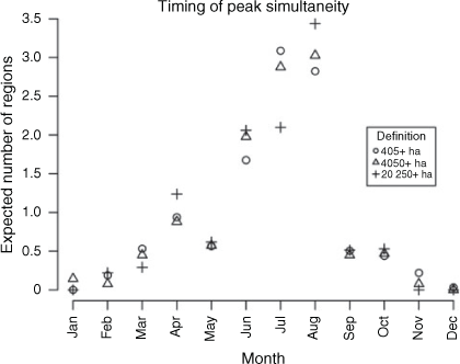
The timing and levels of simultaneity are variable across regions and definitions, but the majority of regions tend to peak around July and August. Under the ALF and VLF definitions, the Eastern Great Basin, Northern California, Northern Rockies, Northwest, Rocky Mountain, Southern California and Western Great Basin regions are expected to have peak simultaneity either during July or August. Under the ELF definition, the Eastern Great Basin, Northern California, Northern Rockies, Northwest, Southern California and Western Great Basin have peak simultaneity during August. A minority of regions are likely to experience peak simultaneity during the spring months. For instance, for all definitions, peak simultaneity is expected in March or April for the Eastern and Southern regions. Moreover, ELF simultaneity in the Southwest tends to peak in April. The actual month of peak varies around the expectation from year to year. For instance, although April is the month that simultaneity most frequently peaks in the Eastern region, simultaneity peaked during another month 50% of the time. Peak VLF simultaneity has occurred as early as January in the Alaska, Rocky Mountain, Southern California and Southern regions, and as late as November in the Southern region. Peak ALF simultaneity has occurred in December in the Southern region (Fig. 3). The all-time maximum peak simultaneity did not always occur during the modal peak simultaneity month. For instance, the highest ALF and VLF simultaneity counts in the Eastern region occurred during an outbreak between October and November 1991, but the most typical peak simultaneity month is in April. The expected number of regions experiencing peak simultaneity at the same time is maximal in July or August. Under the ALF and VLF simultaneity definition, the number of regions with peak simultaneity is highest in July; under the ELF definition, this quantity is highest in August (Fig. 4).

|
|
Observed changes in peak simultaneity
Statistically significant changes in peak simultaneity levels were detected in the Alaska, Northern Rockies, Southwest and Southern regions. Strongly significant increases in peak ELF simultaneity were noted in the Southwest regions, but the average increase was relatively small, with 1.1 additional fires during peak simultaneity in 2000–15 compared with 1984–99. Significant increases were observed in Alaska as well, with a slightly larger average increase of 4.6 additional ELFs during peak simultaneity in 2000–15 compared with 1984–99. Peak ALF simultaneity significantly increased in Northern Rockies and Southern regions, and peak VLF simultaneity significantly increased in the Northern Rockies region. Decreases in mean peak annual simultaneity were observed in some regions, but the changes were never statistically significant (Fig. 5). The largest absolute increase in the mean peak annual simultaneity is observed in the Alaska region, which had average peak ALF simultaneity of 12.3 in 1984–99 compared with 28.9 in 2000–15; however, the difference is not statistically significant. The largest statistically significant increase in the mean peak annual simultaneity is observed in the Northern Rockies, which had a peak annual simultaneity of 9.3 in 1984–99 compared with 22.4 in 2000–15.

|
In addition to the increases in simultaneity between the halves of the historical record presented above, statistically significant temporal trends in peak simultaneity were detected in Alaska, Northern Rockies, Southern California, Southern and Southwest regions. Under the ELF simultaneity definition, strongly statistically significant positive correlations were detected in the Southwest region. Statistically significant positive correlations in ELF simultaneity also occurred in the Alaska region. Under the ALF definition, significant increases were observed in the Southern region and significant decreases in the Southern California region. Under the VLF definition, significant increases were detected in the Northern Rockies, Southern and Southwest regions.
Cross-regional simultaneity correlation
Under the ALF simultaneity definition, detectable regional autocorrelations are observed for nearly every pair of regions. One exception to this is the Eastern and Southern regions, which although very strongly and positively autocorrelated with one another are fairly uncorrelated with other regions. In the Eastern region, ALF simultaneity is strongly and negatively autocorrelated with ALF simultaneity in the Eastern Great Basin, Northern California and the Northwest, and strongly and positively autocorrelated with ALF simultaneity in the Southwest region. In the Southern region, ALF simultaneity is very strongly and positively autocorrelated with ALF simultaneity in Rocky Mountain and Southwest regions. Detectable autocorrelations occur less frequently under the VLF and ELF simultaneity definitions, particularly in the Southwest. Although being detectably autocorrelated with nearly every other region under the ALF definition, autocorrelations in VLF simultaneity between the Southwest and other GACCs are detectable for Alaska, Eastern Great Basin, Rocky Mountain and Southern regions only. Even fewer autocorrelations are detectable under the ELF definition and the Southwest is only autocorrelated with Alaska. Regardless of the simultaneity definition, strong and positive autocorrelations are detectable between the Eastern Great Basin, Western Great Basin, Northern California, Southern California Northwest and Northern Rockies regions (Fig. 6).

|
Precursors of simultaneity
The best approximating model of simultaneity nearly always uses both dryness and lightning indicators, although there is regional variability in what specific covariates are selected to represent those variable types. For instance, ALF simultaneity uses multiple kinds of dryness indicators depending on the region. Four of the regions use burning index, three use vapour pressure deficit, and the energy release component, 100-h fuel moisture and 1000-h fuel moisture were each used by one region. Similar uncertainty was seen under the ELF and VLF simultaneity definitions. Under ELF simultaneity, the burning index is used in four of the regions to represent landscape flammability, vapour pressure deficit is used in three regions, and energy release component in two regions. Under VLF simultaneity, burning index is used in four regions, vapour pressure deficit, 1000-h fuel moisture and energy release component used in two regions. The lightning indicators, like the dryness indicators, showed no obvious spatial patterns of variable use.
In the models that include both types of indicators, increases in simultaneity are almost always predicted with increasing dryness and lightning activity. Exceptions to this are observed in the Eastern, Southern California and Eastern Great Basin region. In the Eastern region, very strong negative effects of lightning activity are detected for ALF and VLF simultaneity. In the Southern California region, a detectable negative effect of the number of days with lightning is detected for ELF simultaneity. In the Eastern Great Basin region, a negative effect of lightning activity on simultaneity is also observed in the best-approximating model for VLF simultaneity, but the effect is not statistically significant (Fig. 7). Lightning indicators were not included in some models. The best-approximating Northwest models are based solely on vapour pressure deficit and do not include lightning indicators. Additionally, the best-approximating ELF simultaneity model in the Eastern and Northern Rockies region and the best-approximating VLF simultaneity model in Southern California did not use lightning indicators.

|
Akaike weights also show variable levels of model uncertainty across regions and simultaneity definitions. Under the ALF simultaneity definitions, model uncertainty is relatively low. Five regions report a 95% confidence model set that only contains one model, and another three regions report a 95% confidence model set that contains two models under the ALF definition. The highest model uncertainty under the ALF simultaneity definition is observed in the Northwest and Southern California region, which both report five models in the 95% confidence set and an ~40% probability of accurately identifying the best-approximating model. Levels of model uncertainty tended to increase as the size thresholds increased. Under the VLF simultaneity definition, three regions had a 95% confidence set containing a single model, and under the ELF simultaneity definition, no region had a 95% confidence set containing a single model. Even when the probability of correctly identifying the best-approximating model was relatively low, the Akaike weights typically suggested that the structure of the best-approximating model included lightning and dryness indicator components rather than only one or neither of those components (Fig. 8).

|
Discussion
In this paper, we use satellite burned area, preparedness level, gridded dryness indicator and lightning indicator data to better understand five questions about historical simultaneous wildfire occurrence in the United States.
-
How strong are correlations between simultaneity levels and resource demand proxies?
-
What times of year does simultaneity peak in the United States?
-
Have there been any detectable changes in peak simultaneity levels over the 1984–2015 historic regional records?
-
Are there detectable cross-regional autocorrelations in simultaneity?
-
What dryness and lightning indicators produce the best-approximating model of observed simultaneity levels?
Simultaneity and resource demand
Although suppression costs are often assumed to be largely a function of burned area (Calkin et al. 2005) and fire intensity has been implicated as an important factor mediating firefighting effectiveness (Liu et al. 2010), the results of the present study suggest that resource demand may also be explained by simultaneity. We find that preparedness levels often have a detectable and positive relationship with simultaneity, implying that resource demand is expected to be high when simultaneity is high. The observed correlations between simultaneity and resource demand are expected conceptually, consistent with work from others (Bednar et al. 1990; San-Miguel-Ayanz et al. 2013), and in many contexts are also an empirically superior explanatory variable compared with other burned area proxies (Fig. 2). Hence, the results of the present paper support the claim that resource demand is linked to wildfire activity in complex ways that are better described using simultaneous fire proxies in some contexts.
Peak simultaneity
Given the apparent relationship between simultaneity and preparedness levels, regional peak simultaneity levels serve as convenient proxies of the maximum levels of resource demand. Although firefighting demand is related to a suite of other factors (Smith and Gonzalez-Caban 1987), and the extended attack of wildfires can sometimes last for months at a time, the timing of peak simultaneity does represent a time when the number of firefighting resource allocation decisions is likely to be large and the available resources scare. Although July and August were identified as likely peak simultaneity months (Fig. 4), the timing of peak simultaneity can vary by region and year, and for every month, it is possible that some GACC is experiencing peak simultaneity levels (Fig. 4). When high wildfire activities are restricted to one GACC, additional firefighting resources can be requested from National Coordination Centers. When multiple GACCs have high wildfire activity at the same time, the risk of resource scarcity at the National Coordination Centers grows.
Future work should explore the role of climate change on peak simultaneous wildfire occurrence, as projected changes in the timing of other wildfire characteristics have already been noted. Regional shifts in the probabilities of very-large-fire events are expected under climate change that could cause increases in wildfire activity during months when they were not as frequent historically (Barbero et al. 2015; Podschwit et al. 2018a). If simultaneity increases during months that were historically inactive, then a potential effect would be increased resource scarcity. For instance, peak simultaneity rarely occurs in July in the Southern region, and if that were to change, then firefighting resources may be even more stressed than historically. However, shifts in the timing of simultaneity could also improve resource demand if the seasonal patterns of simultaneous wildfire occurrence were to desynchronise and allow more effective sharing of firefighting resources.
Observed changes in peak simultaneity
Detectable increases in historic peak simultaneity are observed in some regions of the United States, with few significant compensatory decreases in others. There is strong evidence that peak ELF simultaneity – the number of co-occurring extremely large wildfires that dispatchers and firefighting managers must consider – has increased in 2000–15 compared with 1984–99 in the Alaska and Southwest regions. There is also evidence that ALF simultaneity has increased in the Northern Rockies and Southern regions, as well as evidence that VLF simultaneity has increased in the Northern Rockies. In many of these cases, positive trends in peak VLF and ELF simultaneity were also observed for many of these regions, with ALF simultaneity in Southern California being the one major exception. Changes in United States resource demand observed over the last two decades could be in part explained by these increases in simultaneous wildfire in key regions, as these changes apparently coincided. Still, it is important that the apparent trends are appropriately contextualised, as the observed increases in wildfire simultaneity over the 1984–2015 records may also represent a return to trends that are expected when considering the long-term record (Doerr and Santín 2016). Moreover, statistical significance should not be conflated with practical significance (Daniel 1977), and the changes in simultaneity reported in the present study may not represent changes that are relevant to firefighting planning and management. Future work should further validate the appropriateness of using peak simultaneity to infer broader trends about resource demand (Belval et al. 2020), and identify what other factors may be relevant to contextualising the effects of simultaneity on resource demand.
Cross-regional simultaneity correlation
Cross-regional correlation of simultaneity is particularly common in the western United States. A block of six regions – Eastern Great Basin, Western Great Basin, Northern California, Southern California, Northwest and Northern Rockies – had simultaneity levels that showed consistent positive correlation, regardless of the choice of simultaneity definition. This result is consistent with findings from Abatzoglou and Kolden (2013), which found evidence of coarse-scale controls of burned area in forested and non-forested ecosystems in the western United States. The results are also consistent with Liu and Wimberly (2015), who found that fire occurrence was the most highly spatially autocorrelated wildfire characteristic they considered. Additionally, under ALF simultaneity, we also found evidence of negative spatial autocorrelation in the Eastern regions with other GACCs, suggesting that when ALF simultaneity is high in the Eastern region, it tends to be low in other regions in the western United States. The spatial autocorrelations identified here could be helpful for prediction and reconstruction of simultaneity in data-poor situations (Littell et al. 2009) and can inform the space–time allocation of firefighting resources.
Precursors of simultaneity
We have identified relationships between simultaneous wildfire occurrence and the environment that have well-approximated observed data. For most regions, we can conclude that a combination of dryness and lightning indicators is a reliable model of simultaneous wildfire occurrence at the GACC scale. As these conditions are associated with increased landscape flammability and ignition frequency, these results are not surprising. The Eastern and Southern California regions were notable exceptions to this pattern as they have a definite negative relationship of lightning activity with simultaneous wildfire (Fig. 7). One possible explanation for this would be similar to that implied by Balch et al. (2017) and Nagy et al. (2018), which is that wildfires are more frequently ignited via anthropogenic means outside the season when lightning would typically facilitate ignition. Hence, although the observed effects of lightning could appear negative, this would actually represent confounding human factors rather than any causal relationship. As the effects of lightning activity on wildfire activity operate on spatial scales finer than those explored in the current analysis (Díaz-Avalos et al. 2001; Balch et al. 2017), it is not surprising that other factors can alter the relationship between lightning frequency and ignition frequency. Hence, the results here need to be interpreted from the correct spatial context, and it would not be appropriate to extrapolate these results to finer spatial scales. Projected changes in dryness in the western United States suggest that increased simultaneity could occur as result of climatic change to dryness indicators (Liu et al. 2010). However, substantial uncertainties exist across various projections of lightning (Finney et al. 2018), which makes qualitative assessments about future simultaneity a further challenge. Other covariates may also provide superior substitute proxies to represent the ignition frequency component, particularly in regions where lightning is a minor ignition source.
Under ELF simultaneity, the Akaike weights were very low and the 95% confidence large, which suggests a high level of model uncertainty. The highest probability of correctly identifying the best-approximating ELF model was low (0.53) and the smallest 95% confidence set still had five models. However, the results for ALF simultaneity had much lower uncertainty, and in many cases, the probability of correctly identifying the best-approximating model was close to 1 and the 95% confidence set contained only one model. Even when model uncertainty was high regarding the specific choice of covariates, the overall structure was fairly certain, as in the majority of cases, we could be highly confident that the best predictions of simultaneity out of those considered in the initial set of candidates were produced from a model that included a dryness indicator and a lightning indicator (Fig. 8).
Additional considerations
Although simultaneity can influence resource demand via multiple mechanisms and shows detectable correlation with resource demand proxies, it still is an incomplete descriptor of resource demand. Other factors also mediate resource demand, some of which may be difficult to translate into quantitative models (Canton-Thompson et al. 2008). Although the levels of resource demand associated with a wildfire should be approximately correlated with size, variability can be high. Small wildfires sometimes require high levels of firefighting resources, and large incidents sometimes relatively little (Smith and Gonzalez-Caban 1987). Hence, extrapolating relationships between fire size and resource demand to individual incidents can sometimes be misleading. The definitions of simultaneity we used are also incomplete descriptors of resource demand because firefighting resource-sharing decisions occur at finer than monthly time scales. Firefighting resources could be strained by brief but exceptionally high simultaneous wildfire occurrence that appears normal when analysing simultaneous wildfire occurrence at monthly time steps. Daily burned area time series data may help with this, but are relatively rare compared with final wildfire area estimates (Taylor et al. 2013) and suffer from data quality issues that make research applications challenging (Podschwit et al. 2018b).
Given our use of administrative firefighting boundaries to aggregate wildfires, our definitions of simultaneity here are vulnerable to the modifiable areal unit problem (Dark and Bram 2007). The results described here could be sensitive to the choice of geographic boundaries, and alternative candidates could easily be proposed. However, the GACC boundaries have the benefit of corresponding to the scale at which resource allocation decisions are made and allow the comparison of simultaneity with resource demand proxies that are most relevant at that scale. This also could be accomplished at the national scale, but at the expense of describing regional variation in the simultaneity patterns. The modifiable areal unit problem is particularly relevant in the Great Basin, which in 2015 combined the Eastern Great Basin and Western Great Basin regions into one administrative unit. The reported changes, correlations and models will be affected by these new boundaries, but insufficient data currently exist to quantify these effects.
Despite the remaining uncertainties, the measures of simultaneous wildfire occurrence described here are a useful proxy for resource demand. The simultaneity measures have conceptual mechanisms for influencing resource scarcity and are correlated with resource demand proxies.
Conclusions
Changes in firefighting resource demand have been evident in recent years in the United States. Although burned area is often attributed as an explanatory factor, simultaneous wildfire occurrence may be a superior proxy in some contexts. In this paper, we demonstrate that (1) simultaneous wildfire occurrence in the United States is often positively correlated with preparedness levels, many times more so than other wildfire characteristics; (2) simultaneous wildfire occurrence often peaks in July and August for many regions; (3) detectable increases and positive trends in simultaneity have occurred in some regions of the western and southern United States over the last three decades; (4) simultaneity in one region is often autocorrelated with simultaneity in others, particularly in the western United States; and (5) the best-approximating models of historic simultaneity reliably come from a combination of dryness and lightning covariates.
Conflicts of interest
The authors declare no conflicts of interest.
Acknowledgements
The authors would like to thank John Abatzoglou, Travis Axe, Melissa Bukovsky, Nathaniel Goodby, Lee Kessenich, Alex Masarie, Seth McGinnis and Linda Mearns for their helpful comments during the formative stages of this work. They would like to acknowledge the Weather and Climate Impacts Assessment Science Program (WCIASP) and the Regional Climate Uncertainty Program (RCUP), funded by the National Center for Atmospheric Research, for funding this work.
References
Abatzoglou JT (2013) Development of gridded surface meteorological data for ecological applications and modelling. International Journal of Climatology 33, 121–131.| Development of gridded surface meteorological data for ecological applications and modelling.Crossref | GoogleScholarGoogle Scholar |
Abatzoglou JT, Kolden CA (2013) Relationships between climate and macroscale area burned in the western United States. International Journal of Wildland Fire 22, 1003–1020.
| Relationships between climate and macroscale area burned in the western United States.Crossref | GoogleScholarGoogle Scholar |
Andela N, Morton DC, Giglio L, Chen Y, Van Der Werf GR, Kasibhatla PS, DeFries RS, Collatz GJ, Hantson S, Kloster S, Bachelet D (2017) A human-driven decline in global burned area. Science 356, 1356–1362.
| A human-driven decline in global burned area.Crossref | GoogleScholarGoogle Scholar | 28663495PubMed |
Balch J, Schoennagel T, Williams A, Abatzoglou J, Cattau M, Mietkiewicz N, St Denis L (2018) Switching on the Big Burn of 2017. Fire 1, 17
| Switching on the Big Burn of 2017.Crossref | GoogleScholarGoogle Scholar |
Balch JK, Bradley BA, Abatzoglou JT, Nagy RC, Fusco EJ, Mahood AL (2017) Human-started wildfires expand the fire niche across the United States. Proceedings of the National Academy of Sciences of the United States of America 114, 2946–2951.
| Human-started wildfires expand the fire niche across the United States.Crossref | GoogleScholarGoogle Scholar | 28242690PubMed |
Barbero R, Abatzoglou JT, Larkin NK, Kolden CA, Stocks B (2015) Climate change presents increased potential for very large fires in the contiguous United States. International Journal of Wildland Fire 24, 892–899.
| Climate change presents increased potential for very large fires in the contiguous United States.Crossref | GoogleScholarGoogle Scholar |
Bednar LF, Mees R, Strauss D (1990) Fire suppression effectiveness for simultaneous fires: an examination of fire histories. Western Journal of Applied Forestry 5, 16–19.
| Fire suppression effectiveness for simultaneous fires: an examination of fire histories.Crossref | GoogleScholarGoogle Scholar |
Belval EJ, Stonesifer CS, Calkin DE (2020) Fire suppression resource scarcity: current metrics and future performance indicators. Forests 11, 217
| Fire suppression resource scarcity: current metrics and future performance indicators.Crossref | GoogleScholarGoogle Scholar |
Bowman DM, Balch J, Artaxo P, Bond WJ, Cochrane MA, D’antonio CM, DeFries R, Johnston FH, Keeley JE, Krawchuk MA, Kull CA (2011) The human dimension of fire regimes on Earth. Journal of Biogeography 38, 2223–2236.
| The human dimension of fire regimes on Earth.Crossref | GoogleScholarGoogle Scholar | 22279247PubMed |
Bradley BA, Curtis CA, Chambers JC (2016) Bromus response to climate and projected changes with climate change. In ‘Exotic brome-grasses in arid and semiarid ecosystems of the western US’. (Eds MJ Germino, JC Chambers, CS Brown) pp. 257–274. (Springer International Publishing: Cham, Switzerland)
Brotons L, Aquilué N, De Cáceres M, Fortin MJ, Fall A (2013) How fire history, fire suppression practices and climate change affect wildfire regimes in Mediterranean landscapes. PLoS One 8, e62392
| How fire history, fire suppression practices and climate change affect wildfire regimes in Mediterranean landscapes.Crossref | GoogleScholarGoogle Scholar | 23658726PubMed |
Calkin DE, Gebert KM, Jones JG, Neilson RP (2005) Forest service large fire area burned and suppression expenditure trends, 1970–2002. Journal of Forestry 103, 179–183.
| Forest service large fire area burned and suppression expenditure trends, 1970–2002.Crossref | GoogleScholarGoogle Scholar |
Canton-Thompson J, Gebert KM, Thompson B, Jones G, Calkin D, Donovan G (2008) External human factors in incident management team decision-making and their effect on large fire suppression expenditures. Journal of Forestry 106, 416–424.
Croux C, Dehon C (2010) Influence functions of the Spearman and Kendall correlation measures. Statistical Methods & Applications 19, 497–515.
| Influence functions of the Spearman and Kendall correlation measures.Crossref | GoogleScholarGoogle Scholar |
Daniel WW (1977) Statistical significance versus practical significance. Science Education 61, 423–427.
Dark SJ, Bram D (2007) The modifiable areal unit problem (MAUP) in physical geography. Progress in Physical Geography 31, 471–479.
| The modifiable areal unit problem (MAUP) in physical geography.Crossref | GoogleScholarGoogle Scholar |
Dennison PE, Brewer SC, Arnold JD, Moritz MA (2014) Large wildfire trends in the western United States,1984–2011. Geophysical Research Letters 41, 2928–2933.
| Large wildfire trends in the western United States,1984–2011.Crossref | GoogleScholarGoogle Scholar |
Díaz-Avalos C, Peterson DL, Alvarado E, Ferguson SA, Besag JE (2001) Space–time modelling of lightning-caused ignitions in the Blue Mountains, Oregon. Canadian Journal of Forest Research 31, 1579–1593.
Doerr SH, Santín C (2016) Global trends in wildfire and its impacts: perceptions versus realities in a changing world. Philosophical Transactions of the Royal Society B: Biological Sciences 371, 20150345
| Global trends in wildfire and its impacts: perceptions versus realities in a changing world.Crossref | GoogleScholarGoogle Scholar |
Dominguez Martin S, Garcia Diez EL (2010) The singular role of the atmospheric stability in forest fires. Atmosfera 23, 129–139.
Drobyshev I, Niklasson M, Linderholm HW (2012) Forest fire activity in Sweden: climatic controls and geographical patterns in 20th century. Agricultural and Forest Meteorology 154–155, 174–186.
| Forest fire activity in Sweden: climatic controls and geographical patterns in 20th century.Crossref | GoogleScholarGoogle Scholar |
Eidenshink J, Schwind B, Brewer K, Zhu Z, Quayle B, Howard S (2007) A project for Monitoring Trends in Burn Severity. Fire Ecology 3, 3–21.
Finney DL, Doherty RM, Wild O, Stevenson DS, MacKenzie IA, Blyth AM (2018) A projected decrease in lightning under climate change. Nature Climate Change 8, 210–213.
| A projected decrease in lightning under climate change.Crossref | GoogleScholarGoogle Scholar |
Flannigan MD, Krawchuk MA, de Groot WJ, Wotton BM, Gowman LM (2009) Implications of changing climate for global wildland fire. International Journal of Wildland Fire 18, 483–507.
| Implications of changing climate for global wildland fire.Crossref | GoogleScholarGoogle Scholar |
González ME, Gómez-González S, Lara A, Garreaud R, Díaz-Hormazábal I (2018) The 2010–2015 megadrought and its influence on the fire regime in central and south-central Chile. Ecosphere 9, e02300
| The 2010–2015 megadrought and its influence on the fire regime in central and south-central Chile.Crossref | GoogleScholarGoogle Scholar |
Goodman SN (2001) Of P-values and Bayes: a modest proposal. Epidemiology 12, 295–297.
| Of P-values and Bayes: a modest proposal.Crossref | GoogleScholarGoogle Scholar | 11337600PubMed |
Gorte RW (2011) Federal funding for wildfire control and management. Congressional Research Service, Report RL33990. (Washington, DC, USA).
Halsey LG (2019) The reign of the P-value is over: what alternative analyses could we employ to fill the power vacuum? Biology Letters 15, 20190174
| The reign of the P-value is over: what alternative analyses could we employ to fill the power vacuum?Crossref | GoogleScholarGoogle Scholar | 31113309PubMed |
Hirsch KG, Martell DL (1996) A review of initial attack fire crew productivity and effectiveness. International Journal of Wildland Fire 6, 199–215.
| A review of initial attack fire crew productivity and effectiveness.Crossref | GoogleScholarGoogle Scholar |
Hoover K (2017) Wildfire management funding: background, issues, and FY2018 appropriations. Congressional Research Service, Report 45005. (Washington, DC, USA)
Hoover K, Lindsay BR, McCarthy FX, Tollesrup J (2015) Wildfire spending: background, issues, and legislation in the 114th Congress. Congressional Research Service, Report 44082. (Washington, DC, USA)
Kass RE, Raftery AE (1995) Bayes factors. Journal of the American Statistical Association 90, 773–795.
| Bayes factors.Crossref | GoogleScholarGoogle Scholar |
Krawchuk MA, Moritz MA, Parisien MA, Van Dorn J, Hayhoe K (2009) Global pyrogeography: the current and future distribution of wildfire. PloS One 4, e5102
Littell JS, McKenzie D, Peterson DL, Westerling AL (2009) Climate and wildfire area burned in western US ecoprovinces, 1916–2003. Ecological Applications 19, 1003–1021.
| Climate and wildfire area burned in western US ecoprovinces, 1916–2003.Crossref | GoogleScholarGoogle Scholar | 19544740PubMed |
Liu Z, Wimberly MC (2015) Climatic and landscape influences on fire regimes from 1984 to 2010 in the western United States. PLoS One 10, e0140839
| Climatic and landscape influences on fire regimes from 1984 to 2010 in the western United States.Crossref | GoogleScholarGoogle Scholar | 26700862PubMed |
Liu Y, Stanturf J, Goodrick S (2010) Trends in global wildfire potential in a changing climate. Forest Ecology and Management 259, 685–697.
| Trends in global wildfire potential in a changing climate.Crossref | GoogleScholarGoogle Scholar |
Lyon KM, Huber-Stearns HR, Moseley C, Bone C, Mosurinjohn NA (2017) Sharing contracted resources for fire suppression: engine dispatch in the north-western United States. International Journal of Wildland Fire 26, 113–121.
| Sharing contracted resources for fire suppression: engine dispatch in the north-western United States.Crossref | GoogleScholarGoogle Scholar |
Magnussen S, Taylor SW (2012) Inter-and intra-annual profiles of fire regimes in the managed forests of Canada and implications for resource sharing. International Journal of Wildland Fire 21, 328–341.
| Inter-and intra-annual profiles of fire regimes in the managed forests of Canada and implications for resource sharing.Crossref | GoogleScholarGoogle Scholar |
McAlpine RS, Wotton BM (1993) The use of fractal dimension to improve wildland fire perimeter predictions. Canadian Journal of Forest Research 23, 1073–1077.
| The use of fractal dimension to improve wildland fire perimeter predictions.Crossref | GoogleScholarGoogle Scholar |
Meyn A, White PS, Buhk C, Jentsch A (2007) Environmental drivers of large, infrequent wildfires: the emerging conceptual model. Progress in Physical Geography 31, 287–312.
| Environmental drivers of large, infrequent wildfires: the emerging conceptual model.Crossref | GoogleScholarGoogle Scholar |
Nagy R, Fusco E, Bradley B, Abatzoglou JT, Balch J (2018) Human-related ignitions increase the number of large wildfires across US ecoregions. Fire 1, 4
| Human-related ignitions increase the number of large wildfires across US ecoregions.Crossref | GoogleScholarGoogle Scholar |
North MP, Stephens SL, Collins BM, Agee JK, Aplet G, Franklin JF, Fulé PZ (2015) Reform forest fire management. Science 349, 1280–1281.
| Reform forest fire management.Crossref | GoogleScholarGoogle Scholar | 26383934PubMed |
O’Donnell AJ, Boer MM, McCaw WL, Grierson PF (2011) Climatic anomalies drive wildfire occurrence and extent in semi-arid shrublands and woodlands of south-west Australia. Ecosphere 2, 1–15.
| Climatic anomalies drive wildfire occurrence and extent in semi-arid shrublands and woodlands of south-west Australia.Crossref | GoogleScholarGoogle Scholar |
Podschwit H, Larkin N, Steel E, Cullen A, Alvarado E (2018a) Multimodel forecasts of very-large-fire occurences during the end of the 21st century. Climate 6, 100
| Multimodel forecasts of very-large-fire occurences during the end of the 21st century.Crossref | GoogleScholarGoogle Scholar |
Podschwit H, Guttorp P, Larkin N, Steel EA (2018b) Estimating wildfire growth from noisy and incomplete incident data using a state space model. Environmental and Ecological Statistics 25, 325–340.
| Estimating wildfire growth from noisy and incomplete incident data using a state space model.Crossref | GoogleScholarGoogle Scholar |
R Core Team (2019) R: A language and environment for statistical computing. (Vienna, Austria) Available at http://www.R-project.org/ [Verified 1 September 2020]
Román-Cuesta RM, Carmona-Moreno C, Lizcano G, New M, Silman M, Knoke TT, Malhi Y, Oliveras I, Asbjornsen H, Vuille M (2014) Synchronous fire activity in the tropical high Andes: an indication of regional climate forcing. Global Change Biology 20, 1929–1942.
| Synchronous fire activity in the tropical high Andes: an indication of regional climate forcing.Crossref | GoogleScholarGoogle Scholar | 24464954PubMed |
San-Miguel-Ayanz J, Moreno JM, Camia A (2013) Analysis of large fires in European Mediterranean landscapes: lessons learned and perspectives. Forest Ecology and Management 294, 11–22.
| Analysis of large fires in European Mediterranean landscapes: lessons learned and perspectives.Crossref | GoogleScholarGoogle Scholar |
Smith EL, Gonzalez-Caban XX (1987) ‘Estimating cost of large-fire suppression for three Forest Service regions (Vol. 391).’ (USDA Forest Service, Pacific Southwest Forest and Range Experiment Station: Berkeley, CA, USA).
Stavros EN, Abatzoglou J, Larkin NK, McKenzie D, Steel EA (2014) Climate and very large wildland fires in the contiguous western USA. International Journal of Wildland Fire 23, 899–914.
| Climate and very large wildland fires in the contiguous western USA.Crossref | GoogleScholarGoogle Scholar |
Steelman T (2016) US wildfire governance as social-ecological problem. Ecology and Society 21, 3
| US wildfire governance as social-ecological problem.Crossref | GoogleScholarGoogle Scholar |
Symonds MR, Moussalli A (2011) A brief guide to model selection, multimodel inference and model averaging in behavioural ecology using Akaike’s information criterion. Behavioral Ecology and Sociobiology 65, 13–21.
| A brief guide to model selection, multimodel inference and model averaging in behavioural ecology using Akaike’s information criterion.Crossref | GoogleScholarGoogle Scholar |
Syphard AD, Radeloff VC, Keeley JE, Hawbaker TJ, Clayton MK, Stewart SI, Hammer RB (2007) Human influence on California fire regimes. Ecological Applications 17, 1388–1402.
| Human influence on California fire regimes.Crossref | GoogleScholarGoogle Scholar | 17708216PubMed |
Syphard AD, Keeley JE, Pfaff AH, Ferschweiler K (2017) Human presence diminishes the importance of climate in driving fire activity across the United States. Proceedings of the National Academy of Sciences 114, 13750–13755.
Taylor SW, Woolford DG, Dean CB, Martell DL (2013) Wildfire prediction to inform fire management: statistical science challenges. Statistical Science 28, 586–615.
| Wildfire prediction to inform fire management: statistical science challenges.Crossref | GoogleScholarGoogle Scholar |
Thompson MP, Calkin DE, Herynk J, McHugh CW, Short KC (2013) Airtankers and wildfire management in the US Forest Service: examining data availability and exploring usage and cost trends. International Journal of Wildland Fire 22, 223–233.
| Airtankers and wildfire management in the US Forest Service: examining data availability and exploring usage and cost trends.Crossref | GoogleScholarGoogle Scholar |
Weiss A, Hays CJ (2005) Calculating daily mean air temperatures by different methods: implications from a non-linear algorithm. Agricultural and Forest Meteorology 128, 57–65.
| Calculating daily mean air temperatures by different methods: implications from a non-linear algorithm.Crossref | GoogleScholarGoogle Scholar |
Westerling AL, Gershunov A, Brown TJ, Cayan DR, Dettinger MD (2003) Climate and wildfire in the western United States. Bulletin of the American Meteorological Society 84, 595–604.
| Climate and wildfire in the western United States.Crossref | GoogleScholarGoogle Scholar |