

Potential conditions for fire occurrence in vegetation in the Peruvian Andes
Ricardo Zubieta A B D , Fernando Prudencio A , Yerson Ccanchi A B , Miguel Saavedra A , Juan Sulca A , Jorge Reupo A and Glory Alarco C
A Instituto Geofísico del Peru (IGP), Subdirección de Ciencias de la Atmósfera e Hidrósfera (SCAH), Calle Badajoz 169 Mayorazgo-Ate, 15012, Peru.
B Universidad Nacional Agraria La Molina, Av. La Molina s/n, La Molina, 15012, Peru.
C Ministerio del Ambiente, Dirección General de Ordenamiento Territorial y Ambiental, Av. Juan de Aliaga 425, Magdalena del Mar, 15076, Peru.
D Corresponding author. Email: rzubieta@igp.gob.pe
International Journal of Wildland Fire 30(11) 836-849 https://doi.org/10.1071/WF21029
Submitted: 2 March 2021 Accepted: 10 September 2021 Published: 12 October 2021
Journal Compilation © IAWF 2021 Open Access CC BY-NC-ND
Abstract
Fire activity in the Peruvian Andes has increased significantly in recent decades, but climatic parameters associated with drought, which may indirectly contribute to the occurrence of severe forest fires, have not yet been investigated. Because fire prevention tools are scarce, strategies for deterring burning are necessary in order to reduce impacts in regions where forest fires usually result from human activity. This study explores the conditions conducive to forest fire in the Andes of Peru. Daily precipitation and temperature observed data from the PISCO gridded dataset for the 2002–2016 period were used. In addition, MODIS satellite images (MOD09A1 product) were collected to characterise Andean vegetation using spectral indices. Analysis of daily temperature and rainfall indicates that climatic parameters such as cumulative precipitation, dry-day frequency and hot-day frequency are statistically associated with conditions that could contribute to increased forest fire occurrence. Our findings suggest that a decrease in the water content of vegetation, estimated by the Global Vegetation Moisture Index during the dry period and wet period onset, can be used to identify potential conditions for forest fire occurrence. This study suggests that forest managers should consider implementing prevention strategies that include continuous monitoring of climate and vegetation parameters.
Keywords: fire management, climate, remote sensing, fire danger, tropical ecosystems, vegetation, droughts, Andes.
Introduction
Fire in the Andes is commonly driven by human ignitions and is mainly associated with forest fuel build-up during the dry season (Román-Cuesta et al. 2011, 2014; Zubieta et al. 2019). Forests or other vegetation are highly flammable during the dry season, because of the high moisture deficit in these ecosystems (e.g. puna, paramo, grassland, shrubland or woods) and forest fuel availability. Forest fire is an ongoing threat and a constant challenge for forest management worldwide, and Amazonian and Andean ecosystems are no exception. The frequency of forest fire varies seasonally, and fire has a severe impact on Amazonian and Andean ecosystems during the dry season. Although local forest fire dynamics can be influenced by human activity, responses also appear to be influenced by climate oscillations (All et al. 2017).
Rainfall increase in the Peruvian eastern Andes is usually consistent with an intensification of the north-east trade winds and with the increase in water vapour transport from the tropical North Atlantic during the wet season (Espinoza et al. 2009). Nonetheless, droughts in 2005 and 2010 were characterised with the weakening of trade winds, which reduced seasonal water vapour transport towards the Peruvian Andes (Espinoza et al. 2011). This in turn led to anomalously low river levels (Marengo and Espinoza 2016) and an increased risk of fire in the region (Garreaud et al. 2017). Indeed, increases in forest fire frequency are naturally associated with extreme drought events in the Amazon Basin (Marengo and Espinoza 2016; Silva et al. 2018; Silva et al. 2020; Pontes-Lopes et al. 2021) and the Andes (Oliveras et al. 2014a, 2018; Román-Cuesta et al. 2014; Zubieta et al. 2019). These drought events are predicted to become more frequent owing to climate change (Silva et al. 2018; dos Reis et al. 2021).
A decrease in rainfall in the Andes is also associated with El Niño in the central Pacific (Lagos et al. 2008; Silva et al. 2008; Lavado-Casimiro and Espinoza 2014; Sulca et al. 2018, 2021). Although El Niño does not show a significant direct relationship with fire activity in the tropical Andes (Román-Cuesta et al. 2014), some regional impacts of the 2016 dry episode have been explained by El Niño events and the South Atlantic Convergence Zone (SACZ) (Jimenez et al. 2021), which created conditions conducive to forest fires. A recent study indicates that the transition process between El Niño and La Niña in the central Pacific is concordant with a sharp increase in the frequency of forest fires in the Andean regions (Zubieta et al. 2019). Therefore, weather plays an important role in the occurrence of forest fires, because it determines ease of ignition, propagation rates and severity (Benson et al. 2008).
Forest fire is also influenced by biophysical factors, such as the development of vegetation cover during the dry season and the presence of ignition agents. Between 2013 and 2017, forest fire severely burned almost 200 000 ha in the Andes and Amazon regions of Peru (SERFOR 2018). The greatest emissions from biomass burning (60–70%) came from burned montane cloud forests (Oliveras et al. 2014b). Frosts are a major hazard to agriculture in the tropical Andes of Peru (Saavedra and Takahashi 2017), and one physical mechanism that could contribute to vegetation degradation is night frost, which desiccates Andean pastures, increasing the likelihood that they could burn in the future (Román-Cuesta et al. 2014). These regions contain large carbon stocks, and their loss through fire and burning is not currently accounted for (Román-Cuesta et al. 2011). Research on forest structure and species composition after fire in tropical montane forest suggests that they take between 9 and 15 years to regenerate, as species diversity increases. (Oliveras et al. 2014a, 2018). Both Andean and Amazonian forests present high rates of deforestation due to human activities (FAO 2007; SERFOR 2018). This degradation was widespread throughout South America in 2019 (BBC 2019). All these vegetation changes and their drivers are indirect influences on fire temporal regimes in the Andes region.
Nevertheless, the fire regime has long been a transformative agent governed by climatic variation in the Andes, where vegetation dynamics are linked to a common climatic driver (Williams et al. 2011). Global climate models suggest enhanced warming of the tropical mid and upper troposphere in the Andes (Vuille and Bradley et al. 2000; Vuille et al. 2008; Zubieta et al. 2021). Possible changes in fire activity are among the significant ecological consequences of rising temperatures in Andean ecosystems (Román-Cuesta et al. 2014).
Because fire suppression is unlikely to be an effective policy (Keating 2007), decision-makers, emergency management agencies, land managers, scientists and the public need the best scientific information possible for fire management. Climate, burn activity, deforestation, land-use change, regulation of biomass burning and interactions among those factors are all relevant for improving forest management (Di Bella et al. 2006). In addition, a balanced preventive approach could mitigate the consequences and contribute to better long-term management of fire damage (Collins et al. 2013).
To predict fires and regulate their impacts, new knowledge is needed about fire activity and the spatial and temporal distribution of factors affecting its occurrence. This is extremely important for agroforestry management and to reduce environmental degradation (Di Bella et al. 2006). The climatic and vegetation conditions conducive to forest fire in the Andes, however, have not been fully studied. To characterise the spatial and temporal distribution of factors that contribute to forest fire occurrence, drought conditions must be thoroughly analysed. Satellites are an alternative source of climate, vegetation and soil datasets that can be assessed based on observed changes in vegetation health and land cover (Asner and Alencar 2010; AghaKouchak et al. 2015; Silva et al. 2018). Because the photosynthetic capacity of plants changes when they are subjected to water stress or drought (Asrar et al. 1984; Asner et al. 2004), these conditions can be detected by satellite sensors as combinations of visible (VIS) and infrared (IR) light (Wardlow et al. 2012).
Satellites can also detect biomass burning (Bradley and Millington 2006). Satellite data about vegetation condition and its biophysical development can be integrated with climate-based drought indices (Wardlow et al. 2012). For example, a significant relationship has been found between the Normalized Difference Vegetation Index (NDVI) and precipitation (Ding et al. 2007; Chamaillé‐Jammes and Fritz 2009). NDVI (or its derivatives) has been widely used for drought assessment and monitoring of vegetation development (Karlsen et al. 2008; Chen et al. 2011). Recent studies in the Amazon Basin have found a strong relationship between NDVI and dry-day frequency (DDF), leading to a better understanding of the impact of atmospheric conditions on vegetation (Espinoza et al. 2016; Gutierrez 2018). In this paper, we concentrate on characterising potential climatic and vegetation conditions using satellite- and ground-based datasets that describe conditions before increased forest fire occurrence in the Peruvian Andes (PA). Forest fires in the PA generally result from human activity and are linked to the expansion of crop areas and pasture and the burning of undergrowth (SERFOR 2018). Drought can cause farmers and ranchers to decide to conduct frequent burns during wet season onset, when water stress is higher in the PA. Extreme droughts are consistent with an increase of as much as 400% in forest fire occurrence in the PA (Zubieta et al. 2019). Thus, forest fires must be studied to implement strategies for reducing and adapting to fire danger in the PA (Manta et al. 2018).
Study area
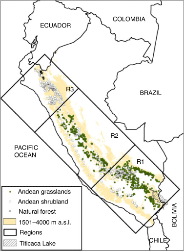
The Andes mountains are the world’s longest continental mountain range, with a maximum elevation of more than 6000 m above sea level (asl). The tropical and subtropical sections of the eastern Andes contain the most dynamic and ecologically diverse ecosystems in South America (Molina and Little 1981; Swenson et al. 2012). The tropical Andes region is also a widely recognised priority for conservation efforts, because its diversity of rare endemic plant and vertebrate species is subject to high rates of anthropogenic disturbance (Myers et al. 2000; Brooks et al. 2006; Bax et al. 2019). The PA (80.1–68.9°W, 4.4–18.2°S) are located along the western Amazon Basin (Fig. 1a, b).

|
The Andean highlands make up ~30% of Peru’s surface area, and their dry valleys, highland mountain valleys and grassland plateaus are home to a great diversity of plant communities (Leon and Young 1996). The puna grassland ecoregion is the main ecosystem associated with fire risk in the high Andes. Fuel accumulation contributes to fire activity in the highly flammable puna ecosystems during dry season and wet season onset (Bush et al. 2005; Di Pasquale et al. 2008). The grassland ecosystem, which has evolved under the influence of humans and their domesticated animals in the PA, has received fairly little scientific attention (Luteyn 1999; Madriñán et al. 2013).
In this paper, the Andes region is considered to be the area above 1500 m asl (Zulkafli et al. 2014), while the Amazon region is considered to be below 1500 m asl on the eastern slope of the Andes (Fig. 1b). Most forest fire (80%) occurs in the Andean zones between 1500 and 4000 m asl. (Zubieta et al. 2019), and this region is considered our study area (Fig. 1b). Average annual precipitation along the PA is between 350 and 1300 mm year−1 (Espinoza et al. 2009; Zubieta et al. 2017). The highest annual precipitation (greater than 1000 mm year−1) occurs mainly over the eastern part of the PA, while the lowest annual precipitation (less than 1000 mm year−1) is found in the highest regions (Espinoza et al. 2009). The southern region of the PA displays a clear southern tropical regime, with a dry season from May to September, an annual rainfall cycle beginning in August and a rainy period from December to March (Espinoza et al. 2009; Zubieta et al. 2021). In the central region of the PA, the amplitude of the annual rainfall cycle shows maximum values between January and March and minima between June and July (Silva et al. 2008). In the northern region, an intermediate regime between the southern tropics and the equator features a very rainy period from January to April (Espinoza et al. 2009). In the present study, dry season and wet season onset are considered to be May–August and September–November respectively.
For comparison, three regions located in the southern, central and northern PA were proposed as study areas for analysing the predominant vegetation type associated with forest fire (Fig. 2). These regions are consistent with the vegetation most threatened by forest fire (Andean grassland and Andean shrubland, among others) (Román-Cuesta et al. 2014; Manta et al. 2018; Saavedra et al. 2020) and with the regionalisation of rainfall documented for the northern, central and southern sections of the western Peruvian Andes, as proposed by Rau et al. (2017).
|
Datasets used
To evaluate the physical conditions of vegetation in the PA, we used the Moderate Resolution Imaging Spectroradiometer (MODIS) MOD09A1 product (collection 006) at a spatial resolution of 500 m. MOD09A1 data cover the 2000–2018 period. The MODIS sensors operate aboard the Terra satellite; their datasets are freely available and provide an estimate of surface spectral reflectance (Bands 1 through 7). These datasets are atmospherically corrected to reduce the effects of energy dispersion caused by concentration of gases and aerosols and Rayleigh scattering (https://modis.gsfc.nasa.gov/) (Wolfe et al. 1998; Vermote et al. 2015). A quality band (sur_refl_state) provided by the MOD09A1 product is used to filter a composite every 8 days.
To improve understanding of the spatial-temporal distribution of forest fire and monitor impacts on ecosystems and biodiversity in Peru, the Peruvian Ministry of the Environment has developed a historical record of forest fire, which is updated daily (http://geoservidor.minam.gob.pe/monitoreo-y-evaluacion/registros-historicos-cfoi/). Forest fire occurrence in the PA is identified using reports provided by the National Information System for Response and Rehabilitation (SINPAD), which is managed by Peru’s National Civil Defence Institute (INDECI).
Reports are freely available and provide an estimate of population, dates, places, and crops and people affected (https://www.indeci.gob.pe/informe/resumen-incendios-forestales/). The location of forest fires is only approximate; the location is subsequently verified using news reports and analysis of decreases in vegetation based on indices derived from satellite data (MINAM 2018a). Datasets are analysed by geographical information systems (GIS). This was used to study the relationship between forest fire occurrence and El Niño in the PA for the 2000–2018 period (Zubieta et al. 2019). The spatial distribution of total forest fires between 2002 and 2018 is plotted in Fig. 2.
To analyse the biophysical impact of climatic factors on vegetation, we used a new gridded rainfall dataset available for Peru, called PISCOp (Peruvian Interpolated data of SENAMHI’s (Servicio Nacional de Meteorología e Hidrología) Climatological and Hydrological Observations). PISCOp contains data for the 1981–2016 period, at 0.1° spatial resolution (Aybar et al. 2020). The algorithm was based on geostatistical and deterministic interpolation methods using three different rainfall sources: (i) ground-based precipitation datasets; (ii) radar-gauge merged precipitation climatologies; and (iii) the Climate Hazards Group Infrared Precipitation (CHIRP) estimates. The precipitation estimates are validated with the highest performance for the Pacific coastal region and the western slope of the Andes (Aybar et al. 2020) and the western part of the cordillera of the Peruvian Andes (Sulca et al. 2021). A rigorous quality-control and gap-infilling procedure was performed to reduce the formation of inhomogeneities (non-climatic breaks). The dataset is currently available at https://piscoprec.github.io/ and is intended to support water management practices. A new gridded temperature dataset called temperature PISCO for Peru was also collected (Huerta et al. 2018).
To analyse vegetation type and forest fire occurrence along the PA, we used the forest map available from the Peruvian Ministry of the Environment at the following link: https://sinia.minam.gob.pe/mapas/mapa-nacional-ecosistemas-peru. To characterise PA topography, a digital elevation model was collected from the Shuttle Radar Topography Mission (SRTM) (Farr and Kobrick 2000).
Methodology
Climatic parameters associated with droughts, which gradually contribute to a severe impact on vegetation, were analysed (Espinoza et al. 2016; Gutierrez 2018). The frequency of dry days and hot days during dry season and rainy season onset (May–November) for the 2000–2016 period was considered. DDF is the accumulated frequency of days with rainfall lower than 1 mm (Espinoza et al. 2016). Hot-day frequency (HDF) was also considered. This is defined as the accumulated frequency of days with a temperature higher than 20°C. Cumulative precipitation (CP) during dry-season and rainy-season onset was also evaluated for comparison. DDF, HDF and CP time series were estimated at 8-day intervals using the average of pixel values consistent with forest fire location based on precipitation and temperature PISCO datasets for the R1, R2 and R3 regions (Fig. 2).
Data pre-processing
The preliminary data processing strategy for the MOD09A1 product included a data filtering process using a 500-m Reflectance Band Quality (BQ) to avoid erroneous values. The MOD09A1 product allows better selection of information per pixel using BQ. This is done to reduce contamination of spectral indices related to clouds, aerosols and snow (Wolfe et al. 1998; Vermote et al. 2015). MODIS data tiles fully cover the PA to generate time series between 2000 and 2018 at 8-day intervals. A total of 5474 data tiles were downloaded and processed, covering the entire PA for the MOD09A1 product. We used a land and water mask to achieve greater accuracy in the interpreted measurements (land surface, oceans, aerosol retrievals, cloud detection, etc.).
Spectral indices
Spectral indices estimated from reflectance signatures result from the presence, absence, position and shape of specific surface absorption features. (i) The NDVI is the most popular index for estimating the amount, quality and growth of vegetation (Rouse et al. 1974). However, other spectral indices are available: (ii) the normalised difference water index (NDWI), which is sensitive to changes in liquid water content of vegetation canopies (Gao 1996); (iii) the Enhanced Vegetation Index (EVI), which is considered a modified NDVI with improved sensitivity for high-biomass regions and capability for vegetation monitoring (Huete et al. 2002); (iv) the soil-adjusted vegetation index (SAVI), which was developed to reduce soil influence on canopy spectra by incorporating a soil adjustment factor into the denominator of the NDVI equation (Huete 1988); (v) the Normalized Difference Infrared Index (NDII), which is widely used to monitor the equivalent water thickness of leaves and canopy (Hunt and Rock 1989); (vi) the Global Environment Monitoring Index (GEMI), which is designed to enhance the contrast between vegetation and other surface types (Pinty and Verstraete 1992); (vii) the Global Vegetation Moisture Index (GVMI), which optimises the retrieval of vegetation water content and minimises perturbing geophysical and atmospheric effects (Ceccato et al. 2002).
Finally, (viii) the Visible Atmospheric Resistant Index (VARI) is a tool for amending atmospheric effects on indices. Each filtered image of surface reflectivity using BQ was used to estimate the indices NDVI, NDWI, EVI, SAVI, NDII, GEMI, GVMI and VARI for the 2000–2018 period (Table 1). To investigate the relationship between climatic variables such as precipitation (P), temperature (T), climatic parameters (CP, DDF and HDF), and spectral indices in relation to accumulated frequency of forest fire (FFO) along the PA, time series for P, T, CP, DDF, HDF and spectral indices (EVI, GEMI, GVMI, NDII, NDVI, NDWI, SAVI, VARI) between May and November were computed at 8-day intervals for the 2002–2016 period. Then, Pearson’s correlation coefficient was applied to analyse the relationship between spectral indices and climatic parameters. If this probability is lower than the conventional 5% (P < 0.05), the correlation coefficient can be called statistically significant. The P value is the probability of obtaining results at least as extreme as the observed results of a statistical hypothesis test, assuming that the null hypothesis is true.

|
Results
Forest fire analysis
Forest fire occurrence (points) and vegetation type provided by the ecosystem map (MINAM 2018b) were analysed using GIS to identify ecosystems that are usually affected by forest fire (Fig. 2). The ecosystems most affected are: (1) grasslands in the Andean puna and paramo; (2) natural forests (dry forest in inter-Andean valleys, dry montane forest and tropical montane cloud forest); and (3) Andean shrubland, among others (Manta et al. 2018; MINAM 2018b). In the R1 region, the greatest fire danger and highest forest fire occurrence are associated with Andean grassland, followed by Andean shrubland (Manta et al. 2018). Forest fire in the R2 region shows a pattern similar to that of R1, but the number of forest fires is lower in R2 than in R1. Forest fire in Andean shrubland is predominant in the R3 region (Fig. 2). This is consistent with the forest fire danger map proposed by Manta et al. (2018).
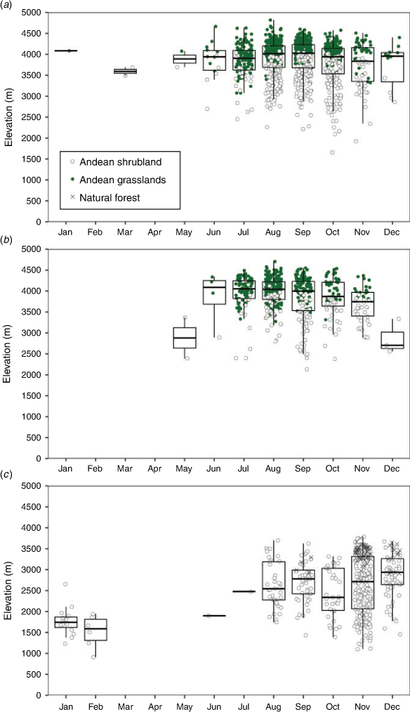
A box plot was graphed for elevation ranges in the PA using the temporal distribution of forest fire occurrence (Fig. 3). It shows that few forest fires occur at an altitude lower than 1500 m asl between January and June (3%). Fig. 3 also shows that most forest fires occur between the dry period and wet period onset (97%). These results mean that forest fires along the entire PA occur at an altitude above 1500 m asl between July and December. A similar temporal pattern of forest fires between July and November is found when the R1 and R2 regions with an altitude between 3500 and 4500 m asl are analysed for Andean grasslands and shrublands (Fig. 3a, b). Forest fire in the R3 region mainly occurs between 2000 and 3000 m asl in Andean shrublands, with the maximum peak in November (Fig. 3c). This suggests that interacting factors, such as population, vegetation, altitude and climate, could contribute to forest fire (Manta et al. 2018; SERFOR 2018; Zubieta et al. 2019).
|
Climatic parameters
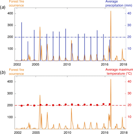
The time series of the number of episodes of forest fire between 2002 and 2016 shows an increase of between 100% and 400% during 2005, 2010 and 2016 (Zubieta et al. 2019). This is consistent with a decrease in average precipitation (below 20 mm) during the dry period (May–September) identified in 2005, 2010 and 2016 (Fig. 4a). In contrast, the average maximum temperature does not show significant change during these drought events between May and September (~20°C) for the 2002–2016 period (Fig. 4b). This suggests that climatic parameters associated with precipitation could represent an opportunity to monitor conditions conducive to forest fire occurrence. Parameters such as CP and DDF were therefore analysed (Fig. 4). HDF was also included in the analysis as a temperature parameter. These parameters were selected because they increase gradually during the dry season and rainy season onset. Forest fires along the PA during the May–November period were prioritised (Fig. 5).
|

|
To analyse climatic parameters that can be associated with increased forest fire occurrence, CP, DDF and HDF were evaluated for the three regions proposed (Fig. 2 and Fig. 5a–i). On average, the CP increases gradually from May to September, reaching up to ~100 mm. The wet period then begins in the PA, becoming more intense and reaching values between 200 and 300 mm by November or December for the R1, R2 and R3 regions (Fig. 5a, d, g). Similarly, DDF shows an increase between May and September up to ~80–100 days. The wet period in the PA begins in September, when DDF is approximately stabilised for the R1, R2 and R3 regions (Fig. 5b, e, h).
As expected, HDF tends to increase from May to November (Fig. 5c, f, i) for the R1, R2 and R3 regions. The years 2005, 2010 and 2016 can be considered as showing extreme conditions for CP (the lowest values), DDF (the highest values) and HDF (the highest values) (Fig. 5) for the prioritised R1 and R2 regions (Figs 2 and 5). However, only HDF and DDF parameters for the R3 region for 2005, 2010 and 2016 show increasing and differentiated behaviour for 2002 and 2016 (Fig. 5i). This suggests that CP is not appropriate for analysing extreme droughts in the R3 region in the northern PA (Fig. 5g, h, Fig. 2).
The highest forest fire occurrence in 2005, 2010 and 2016 and the drought events that occurred are consistent in the Andes and Amazon regions (Marengo and Espinoza 2016; Jimenez et al. 2021). This suggests that CP, DDF and HDF can be considered climatic parameters with potential for monitoring conditions conducive to forest fire.
Analysis of spectral indices
T and P do not significantly correlate with spectral indices or climatic parameters (r ~0.2). This indicates that climatic variables are not directly appropiate for monitoring conditions conducive to forest fire (Figs 6–8). However, FFO is highly correlated with HDF (0.71, P < 0.05), followed by DDF (0.57, P < 0.05) and CP (0.48, P < 0.05) (Fig. 6) for the R1 region. Similar correlation coefficients are found for the R2 and R3 regions, indicating that climatic parameters can be more useful for estimating possible indirect impacts on forest fire frequency (Figs 7 and 8).

|

|

|
As expected, DDF, CP and HDF negatively affect every spectral index analysed (Figs 6–8). The relationship between DDF and GVMI is highly negative for the R1 (–0.88, P < 0.05), R2 (–0.65, P < 0.05) and R3 (–0.61, P < 0.05) regions; this indicates that the estimations associated with vegetation water content tend to decrease sharply when DDF is higher. This is also consistent with the negative correlation found between GVMI and HDF for the R1 (–0.62, P < 0.05), R2 (–0.54, P < 0.05) and R3 (–0.74, P < 0.05) regions. A negative relationship between GVMI and FFO for the R1 (–0.46, P < 0.05), R2 (–0.46, P < 0.05) and R3 (–0.41, P < 0.05) regions is also observed. This indicates that monitoring of spectral indices associated with vegetation during the dry period and wet period onset could detect drought conditions that contribute to conditions more conducive to forest fire occurrence.
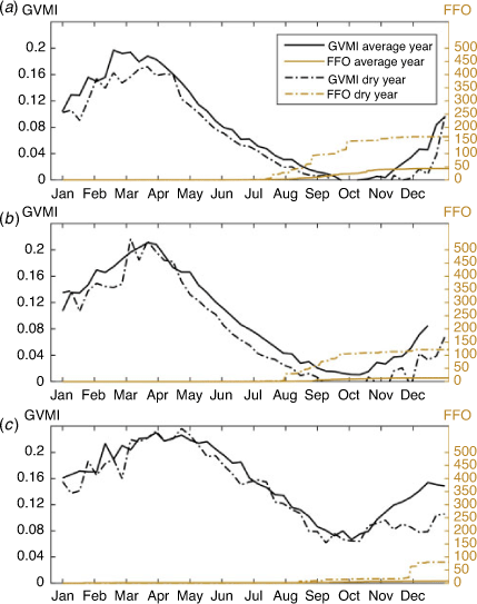
The spectral indices analysed in this study are highly correlated among themselves (r ~0.9; P < 0.05) for the May–November period. It is worth noting that of the spectral indices, GVMI is more closely associated with climatic parameters such as CP, DDF, HDF and FFO than others indices (EVI, GEMI, NDII, NDVI, NDWI, SAVI, VARI) (Figs 6–8). For comparative reasons, GVMI and FFO were plotted for an average year and average dry year (2005, 2010 and 2016) for R1, R2 and R3 (Fig. 9a–c). GVMI presents increasing values between October and April, which decrease from May to September for every region (R1, R2 and R3) (Fig. 9a–c); this is similar to the temporal distribution of precipitation in the PA (Silva et al. 2008; Espinoza et al. 2009). Below-average GVMI values during 2005, 2010 and 2016 are associated with drought events that had indirect impacts on forest fire frequency (Fig. 9). FFO shows a sharp increase mainly from August to November when a drought year occurs in R1 and R2 in the PA (Fig. 9a, b). However, this sharp increase in forest fire mainly begins in November for R3 (Fig. 9c). This is probably due to differences in the effects of vegetation and climate on forest fire in the PA.
|
It is important to note that the low values of the GVMI between January and June could help with the monitoring and prediction of conditions that could contribute to increased forest fire frequency between August and November (Fig. 9). The high correlation among the indices (r > 0.8; P < 0.05) suggests that EVI, GEMI, GVMI, NDII, NDVI, NDWI, SAVI and VARI could be also useful for monitoring vegetation status during the dry period and rainy season onset in the Andes (Figs 6–8).
Threshold indices for CP, DDF, HDF, EVI, GEMI, GVMI, NDII, NDVI, NDWI and SAVI that characterise average and drought conditions at the beginning of the fire season (July) are proposed in Table 2. Monitoring these values can help prevent the inter-annual increase in forest fire frequency during the end of the dry period in the PA, when strategies for deterring burning should be a priority for forest management.

|
Discussion
The results of this study show the possible relationship between forest fire occurrence and climate parameters (CP, DDF and HDF) for the southern and central regions during the 2000–2016 period in the PA. This is consistent with studies in the Amazon Basin, where a strong negative relationship between vegetation conditions and DDF was found (Espinoza et al. 2016; Gutierrez 2018).
CP is not appropriate for analysing forest fire occurrence in the northern region of the PA. This is probably because of the different seasonal role that rainfall plays in forest fire occurrence between August and November in the northern and southern regions of the PA. In fact, a particularly strong contrast between the northern and southern tropics associated with the alternating warming of each hemisphere and the presence of the South American monsoon system is observed (Espinoza et al. 2009). This is also seen in equatorial regions in upper intra-Andean basins, where there is a marked bimodal rainfall regime, with a main peak in April and a second one in October and two minima during the austral winter (June–August) and in December (Laraque et al. 2007; Espinoza et al. 2009).
In the last two decades, research has documented changes in precipitation and impacts on streamflows in the Amazonian and Andean basins (Espinoza et al. 2009; Espinoza et al. 2011; Espinoza et al. 2016; Marengo and Espinoza 2016). In the present study, the impact of drought on vegetation is documented. This impact is characterised by a decrease in every spectral index estimated from remote sensing during the dry season and wet season onset (NDVI, NDWI, EVI, SAVI, NDII, GEMI, GVMI, VARI). This was clearest during the May–November period for 2005, 2010 and 2016 (drought years) (Espinoza et al. 2011; Jimenez et al. 2021).
Of the various spectral indices, the GVMI is indirectly more closely associated with DDF, followed by HDF and CP. This suggests that the decrease in vegetation water content estimated by GVMI during the dry season and rainy season onset contributes to increasing forest fire occurrence between June and November. Indeed, droughts in 2005, 2010 and 2016 (Espinoza et al. 2011; Marengo and Espinoza 2016; Gutierrez 2018; Jimenez et al. 2021) contributed to an increase of ~400% in forest fire occurrence (Zubieta et al. 2019). These droughts in the PA were also associated with El Niño in the central Pacific (Lavado-Casimiro and Espinoza 2014; Lagos et al. 2008; Silva et al. 2008; Jimenez et al. 2021).
The significant rise in HDF and DDF could be associated with the impact of drought between May and September (dry season and rainy season onset). An increase in conditions conducive to forest fires during this season is worrying, as demand for water and presence of forest fuel in mountain ecosystems peak at this time (Román-Cuesta et al. 2011; Oliveras et al. 2014b; Román-Cuesta et al. 2014; SERFOR 2018).
Drought can lead farmers and ranchers to decide to carry out frequent burns that can ignite intense forest fires. Factors particularly conducive to forest fire occurrence are also increased rainfall before the fire season, followed by drought spells and unusually low temperatures (Román-Cuesta et al. 2014). This suggests that forest fuel should be managed by decision-makers and policy-makers between the end of the dry season and onset of the wet season in the PA, because forest fires are generally caused by humans (SERFOR 2018). The present paper therefore proposes alternative tools for monitoring conditions that could increase forest fire occurrence using several climatic variables, climatic parameters and spectral indices from satellite datasets that characterise the vegetation in the PA.
Monitoring of these climatic parameters can be used as a tool for prevention and deterrence with regard to burning in the Andes during the dry period. The extreme variability of rainfall in the Andes (Espinoza et al. 2009) suggests the need for regional monitoring. Reliable quantification of the spatial and temporal distribution of precipitation is crucial for analysing drought events in quasi-real time. Satellites can provide an alternative source of climate datasets for monitoring cumulative precipitation and DDF. The GPM (Global Precipitation Measurement) satellite datasets should be tested and compared with ground-based precipitation data for the PA. The GPM provides next-generation global observation of rainfall from an international network of satellites (Schwaller and Morris 2011).
Conclusions
For forest fire prevention, decision-makers, emergency management institutes, land managers, farmers and ranchers require the best possible scientific information in real or quasi-real time. Because response mechanisms are expensive, fire suppression is unlikely to be the most effective management policy (Keating 2007).
At an inter-annual scale, an increase in forest fire has been observed along the PA. This study proposes monitoring potential conditions that increase forest fire occurrence by using several climatic variables and spectral indices from remote sensing during dry season and wet season onset. Climatic variables such as precipitation or temperature are not directly linked with forest fire. However, climatic parameters such as HDF followed by CP and DDF are statistically associated with conditions that could contribute to increased forest fire occurrence.
Compared with other spectral indices, the GVMI, which estimates vegetation water content using MODIS datasets from the TERRA satellite, appears to be the most appropriate for use as a seasonal prevention tool for identifying conditions that contribute to forest fire occurrence during the dry season.
Thresholds for the northern, central and southern regions of the PA, identified during the dry season, are proposed. Severe forest fires that occur in Andean vegetation, such as grassland and shrubland, are also associated with drought in the Andes regions. Our findings can be used by emergency management agencies to enhance forest management decision making through monitoring of climate parameters and GVMI monitoring.
Data availability statement
The data used to generate the results in the paper are available in the following repositories:
-
https://www.senamhi.gob.pe/?p-prensa&n=1003; https://www.senamhi.gob.pe/load/file/01402SENA-8.pdf
-
https://geoservidor.minam.gob.pe/monitoreo-y-evaluacion/cfoi/
Conflicts of interest
The authors declare no conflicts of interest.
Declaration of funding
This research did not receive any specific funding.
Acknowledgements
The authors would like to thank the National Meteorology and Hydrology Service (SENAMHI) of Peru for providing the temperature and precipitation PISCO datasets (www.senamhi.gob.pe). The authors also acknowledge GSFC/NASA for providing the MODIS MOD09A1 product. Ricardo Zubieta would like to express his gratitude to the Ministry of Environment of Peru for providing the forest fire datasets. Suggestions from B. Fraser were greatly appreciated.
References
AghaKouchak A, Farahmand A, Melton FS, Teixeira J, Anderson MC, Wardlow MD, Hain CR (2015) Remote sensing of drought: Progress, challenges and opportunities Reviews of Geophysics 53, 452–480.| Remote sensing of drought: Progress, challenges and opportunitiesCrossref | GoogleScholarGoogle Scholar |
All J, Medler M, Arques S, et al (2017) Fire response to local climate variability: Huascarán National Park, Peru. Fire Ecology 13, 85–104.
| Fire response to local climate variability: Huascarán National Park, Peru.Crossref | GoogleScholarGoogle Scholar |
Asner GP, Alencar A (2010) Drought impacts on the Amazon forest: The remote sensing perspective. New Phytologist 187, 569–578.
| Drought impacts on the Amazon forest: The remote sensing perspective.Crossref | GoogleScholarGoogle Scholar |
Asner GP, Nepstad D, Cardinot G, Ray D (2004) Drought stress and carbon uptake in an Amazon forest measured with spaceborne imaging spectroscopy. Proceedings of the National Academy of Sciences of the United States of America 101, 6039–6044.
| Drought stress and carbon uptake in an Amazon forest measured with spaceborne imaging spectroscopy.Crossref | GoogleScholarGoogle Scholar | 15071182PubMed |
Asrar G, Fuchs M, Kanemasu E, Hatfield J (1984) Estimating absorbed photosynthetic radiation and leaf area index from spectral reflectance in wheat. Agronomy Journal 76, 300–306.
| Estimating absorbed photosynthetic radiation and leaf area index from spectral reflectance in wheat.Crossref | GoogleScholarGoogle Scholar |
Aybar C, Fernández C, Huerta A, Lavado W, Vega F, Felipe-Obando O (2020) Construction of a high-resolution gridded rainfall dataset for Peru from 1981 to the present day. Hydrological Sciences Journal 65, 770–785.
| Construction of a high-resolution gridded rainfall dataset for Peru from 1981 to the present day.Crossref | GoogleScholarGoogle Scholar |
Bax V, Francesconi W, Delgado A (2019) Land-use conflicts between biodiversity conservation and extractive industries in the Peruvian Andes. Journal of Environmental Management 232, 1028–1036.
| Land-use conflicts between biodiversity conservation and extractive industries in the Peruvian Andes.Crossref | GoogleScholarGoogle Scholar | 33395755PubMed |
BBC (2019) Fires in the Amazon: the record number of fires that affect Brazil and also devastate other countries in South America. Available at https://www.bbc.com/mundo/noticias-america-latina-49426794 [Verified 13 September 2019]
Benson R, Roads J, Weise D (2008) Climatic and weather factors affecting fire occurrence and behavior. Developments in Environmental Science 8, 37–59.
| Climatic and weather factors affecting fire occurrence and behavior.Crossref | GoogleScholarGoogle Scholar |
Bradley AV, Millington AC (2006) Spatial and temporal scale issues in determining biomass burning regimes in Bolivia and Peru. International Journal of Remote Sensing 27, 2221–2253.
| Spatial and temporal scale issues in determining biomass burning regimes in Bolivia and Peru.Crossref | GoogleScholarGoogle Scholar |
Brooks TM, Mittermeier RA, da Fonseca GA, Gerlach J, Hoffmann M, Lamoreux JF, Mittermeier CG, Pilgrim JD, Rodrigues AS (2006) Global biodiversity conservation priorities. Science 313, 58–61.
| Global biodiversity conservation priorities.Crossref | GoogleScholarGoogle Scholar | 16825561PubMed |
Bush M, Hansen B, Rodbell D, et al (2005) A 17 000-year history of Andean climate and vegetation change from Laguna de Chochos, Peru. Journal of Quaternary Science 20, 703–714.
| A 17 000-year history of Andean climate and vegetation change from Laguna de Chochos, Peru.Crossref | GoogleScholarGoogle Scholar |
Ceccato P, Gobron N, Flasse S, Pinty B, Tarantola S (2002) Designing a spectral index to estimate vegetation water content from remote sensing data: Part 1. Theoretical approach. Remote Sensing of Environment 82, 188–197.
| Designing a spectral index to estimate vegetation water content from remote sensing data: Part 1. Theoretical approach.Crossref | GoogleScholarGoogle Scholar |
Chamaillé‐Jammes S, Fritz H (2009) Precipitation–NDVI relationships in eastern and southern African savannas vary along a precipitation gradient. International Journal of Remote Sensing 30, 3409–3422.
| Precipitation–NDVI relationships in eastern and southern African savannas vary along a precipitation gradient.Crossref | GoogleScholarGoogle Scholar |
Chen FJ, Shen YJ, Hu QL, Qi YQ, Zhang YC (2011) Responses of NDVI to climate change in the Hai Basin. Journal of Remote Sensing 15, 401–414.
| Responses of NDVI to climate change in the Hai Basin.Crossref | GoogleScholarGoogle Scholar |
Collins RD, De Neufville R, Claro J, Oliveira T, Pacheco AP (2013) Forest fire management to avoid unintended consequences: A case study of Portugal using system dynamics. Journal of Environmental Management 130, 1–9.
| Forest fire management to avoid unintended consequences: A case study of Portugal using system dynamics.Crossref | GoogleScholarGoogle Scholar | 24036501PubMed |
Di Bella CM, Jobbágy EG, Paruelo JM, Pinnock S (2006) Continental fire density patterns in South America. Global Ecology and Biogeography 15, 192–199.
| Continental fire density patterns in South America.Crossref | GoogleScholarGoogle Scholar |
Di Pasquale G, Marziano M, Impagliazzo S, Lubritto C, de Natale A, Bader MY (2008) The Holocene treeline in the northern Andes (Ecuador): first evidence from soil charcoal. Palaeogeography, Palaeoclimatology, Palaeoecology 259, 17–34.
| The Holocene treeline in the northern Andes (Ecuador): first evidence from soil charcoal.Crossref | GoogleScholarGoogle Scholar |
Ding M, Zhang Y, Liu L, et al (2007) The relationship between NDVI and precipitation on the Tibetan Plateau. Journal of Geographical Sciences 17, 259–268.
| The relationship between NDVI and precipitation on the Tibetan Plateau.Crossref | GoogleScholarGoogle Scholar |
dos Reis M, de Alencastro Graça PML, Yanai AM, Pacheco CJ, Fearnside RPM (2021) Forest fires and deforestation in the central Amazon: Effects of landscape and climate on spatial and temporal dynamics. Journal of Environmental Management 288, 112310
| Forest fires and deforestation in the central Amazon: Effects of landscape and climate on spatial and temporal dynamics.Crossref | GoogleScholarGoogle Scholar | 33761331PubMed |
Espinoza JC, Ronchail J, Guyot JL, Cocheneau G, Filizola N, Lavado W, de Oliveira E, Pombosa R, Vauchel P (2009) Spatio-temporal rainfall variability in the Amazon Basin Countries (Brazil, Peru, Bolivia, Colombia and Ecuador). International Journal of Climatology 29, 1574–1594.
| Spatio-temporal rainfall variability in the Amazon Basin Countries (Brazil, Peru, Bolivia, Colombia and Ecuador).Crossref | GoogleScholarGoogle Scholar |
Espinoza JC, Ronchail J, Guyot JL, Junquas C, Vauchel P, Lavado W, Pombosa R (2011) Climate variability and extreme drought in the upper Solimões River (Western Amazon Basin): Understanding the exceptional 2010 drought. Geophysical Research Letters 38, L1340–6.
| Climate variability and extreme drought in the upper Solimões River (Western Amazon Basin): Understanding the exceptional 2010 drought.Crossref | GoogleScholarGoogle Scholar |
Espinoza JC, Segura H, Ronchail J, Drapeau G, Gutierrez-Cori O (2016) Evolution of wet- and dry-day frequency in the western Amazon basin: Relationship with atmospheric circulation and impacts on vegetation. Water Resources Research 52, 8546–8560.
| Evolution of wet- and dry-day frequency in the western Amazon basin: Relationship with atmospheric circulation and impacts on vegetation.Crossref | GoogleScholarGoogle Scholar |
FAO (2007) Manejo del fuego: Principios y acciones estratégicas. Directrices de manejo voluntario para el manejo de fuego. Documento de trabajo sobre Manejo de Fuego No. 17S. Roma. Available at http://www.fao.org/tempref/docrep/fao/009/j9255s/j9255s00.pdf [Verified 13 September 2019]
Farr TG, Kobrick M (2000) Shuttle radar topography mission produces a wealth of data Eos 81, 583–585.
| Shuttle radar topography mission produces a wealth of dataCrossref | GoogleScholarGoogle Scholar |
Gao BC (1996) NDWI – a Normalized Difference Water Index for remote sensing of vegetation liquid water from space. Remote Sensing of Environment 58, 257–266.
| NDWI – a Normalized Difference Water Index for remote sensing of vegetation liquid water from space.Crossref | GoogleScholarGoogle Scholar |
Garreaud RD, Alvarez-Garreton C, Barichivich J, Boisier JP, Christie D, Galleguillos M, LeQuesne C, McPhee J, Zambrano-Bigiarini M (2017) The 2010–2015 megadrought in central Chile: impacts on regional hydroclimate and vegetation. Hydrology and Earth System Sciences 21, 6307–6327.
| The 2010–2015 megadrought in central Chile: impacts on regional hydroclimate and vegetation.Crossref | GoogleScholarGoogle Scholar |
Gitelson AA, Kaufman YJ, Stark R, Rundquist D (2002) Novel algorithms for remote estimation of vegetation fraction. Remote Sensing of Environment 80, 76–87.
| Novel algorithms for remote estimation of vegetation fraction.Crossref | GoogleScholarGoogle Scholar |
Gutierrez O (2018) Estimación de índices de sequía mediante sensoramiento remoto integrando MODIS y TRMM en la Cuenca Andino–Amazónica, Peru. MS thesis, Universidad Nacional Agraria la Molina, Lima, Peru.
Huerta A, Aybar C, Lavado-Casimiro W (2018) PISCO temperaturav.1.1. SENAMHI-DHI. (Lima, Peru)
Huete A, Didan K, Miura T, Rodríguez EP, Gao X, Ferreira LG (2002) Overview of the radiometric and biophysical performance of the MODIS vegetation indices. Remote Sensing of Environment 83, 195–213.
| Overview of the radiometric and biophysical performance of the MODIS vegetation indices.Crossref | GoogleScholarGoogle Scholar |
Huete AR (1988) A soil-adjusted vegetation index (SAVI). Remote Sensing of Environment 25, 295–309.
| A soil-adjusted vegetation index (SAVI).Crossref | GoogleScholarGoogle Scholar |
Hunt E, Rock BN (1989) Detection of changes in leaf water content using near-infrared and middle-infrared reflectances. Remote Sensing of Environment 30, 43–54.
| Detection of changes in leaf water content using near-infrared and middle-infrared reflectances.Crossref | GoogleScholarGoogle Scholar |
Jimenez JC, Marengo J, Alves L, Sulca JC, Takahashi K, Ferret S, Collins M (2021) The role of ENSO flavors and TNA on recent droughts over Amazon forests and the Northeast Brazil region. International Journal of Climatology 41, 3761–3780.
| The role of ENSO flavors and TNA on recent droughts over Amazon forests and the Northeast Brazil region.Crossref | GoogleScholarGoogle Scholar |
Karlsen SR, Tolvanen A, Kubin E, Poikolainen J, Høgda KA, Wielgolaski FE, et al (2008) MODIS-NDVI-based mapping of the length of the growing season in northern Fennoscandia. International Journal of Applied Earth Observation and Geoinformation 10, 253–266.
| MODIS-NDVI-based mapping of the length of the growing season in northern Fennoscandia.Crossref | GoogleScholarGoogle Scholar |
Keating P (2007) Fire ecology and conservation in the high tropical Andes: Observations from northern Ecuador. Journal of Latin American Geography 6, 43–62.
| Fire ecology and conservation in the high tropical Andes: Observations from northern Ecuador.Crossref | GoogleScholarGoogle Scholar |
Lagos P, Silva Y, Nickl E, Mosquera K (2008) El Niño, climate variability and precipitation extremes in Peru. Advances in Geosciences 14, 231–237.
| El Niño, climate variability and precipitation extremes in Peru.Crossref | GoogleScholarGoogle Scholar |
Laraque A, Ronchail J, Cochonneau G, Pombosa R, Guyot JL (2007) Heterogeneous distribution of rainfall and discharge regimes in the Ecuadorian Amazon basin. Journal of Hydrometeorology 8, 1364–1381.
| Heterogeneous distribution of rainfall and discharge regimes in the Ecuadorian Amazon basin.Crossref | GoogleScholarGoogle Scholar |
Lavado-Casimiro W, Espinoza JC (2014) Impact of El Niño and La Niña events on rainfall in Peru. Revista Brasileira de Meteorologia 29, 171–182.
| Impact of El Niño and La Niña events on rainfall in Peru.Crossref | GoogleScholarGoogle Scholar |
Leon B, Young KR (1996) Aquatic plants of Peru: diversity, distribution and conservation. Biodiversity and Conservation 5, 1169–1190.
| Aquatic plants of Peru: diversity, distribution and conservation.Crossref | GoogleScholarGoogle Scholar |
Luteyn JL (1999) ‘Páramos: a checklist of plant diversity, geographical distribution and botanical literature.’ (New York Botanical Garden Press: Brooklyn, NY)
Madriñán S, Cortés AJ, Richardson JE (2013) Páramo is the world’s fastest evolving and coolest biodiversity hotspot. Frontiers in Genetics 4, 1–7.
| Páramo is the world’s fastest evolving and coolest biodiversity hotspot.Crossref | GoogleScholarGoogle Scholar |
Manta MI, Kometter R, Navia A (2018) Evaluation of wildfire danger in the Peruvian Andes: First step for its reduction and adaptation. In ‘VIII International Conference on Forest Fire Research’, Coimbra, Portugal, pp. 44–56. (Imprensa da Universidade de Coimbra)
Marengo JA, Espinoza JC (2016) Extreme seasonal droughts and floods in Amazonia: causes, trends and impacts. International Journal of Climatology 36, 1033–1050.
| Extreme seasonal droughts and floods in Amazonia: causes, trends and impacts.Crossref | GoogleScholarGoogle Scholar |
MINAM (2018a) Dirección General de Ordenamiento Territorial Ambiental (DGOTA). Registro histórico de incendios sobre la cobertura vegetal a nivel nacional. Ministerio del Ambiente-Peru. Available at http://geoservidor.minam.gob.pe/monitoreo-y-evaluacion/registros-historicos-cfoi/ [Verified 15 December 2020]
MINAM (2018b) Mapa nacional de ecosistemas del Perú. Ministerio del Ambiente-Perú. Resolución Ministerial No. 440–2018-MINAM. Available at https://sinia.minam.gob.pe/mapas/mapa-nacional-ecosistemas-peru [Verified 16 August 2021]
Molina E, Little A (1981) Geoecology of the Andes: The natural science basis for research planning. Mountain Research and Development 1, 115–144.
| Geoecology of the Andes: The natural science basis for research planning.Crossref | GoogleScholarGoogle Scholar |
Myers N, Mittermeier RA, Mittermeier CG, Da Fonseca GA, Kent J (2000) Biodiversity hotspots for conservation priorities. Nature 403, 853–858.
| Biodiversity hotspots for conservation priorities.Crossref | GoogleScholarGoogle Scholar | 10706275PubMed |
Oliveras I, Malhi Y, Salinas N, Huaman V, Urquiaga-Flores E, Kala-Mamani J, Quintano-Loaiza JA, Cuba-Torres I, Lizarraga-Morales N, Román-Cuesta RM (2014a) Changes in forest structure and composition after fire in tropical montane cloud forests near the Andean treeline Plant Ecology & Diversity 7, 329–340.
| Changes in forest structure and composition after fire in tropical montane cloud forests near the Andean treelineCrossref | GoogleScholarGoogle Scholar |
Oliveras I, Anderson LO, Malhi Y (2014b) Application of remote sensing to understanding fire regimes and biomass burning emissions of the tropical Andes. Global Biogeochemical Cycles 28, 480–496.
| Application of remote sensing to understanding fire regimes and biomass burning emissions of the tropical Andes.Crossref | GoogleScholarGoogle Scholar |
Oliveras I, Román-Cuesta RM, Urquiaga-Flores E, Quintano Loayza JA, Kala J, Huamán V, Lizárraga N, Sans G, Quispe K, Lopez E, Lopez D, Cuba Torres I, Enquist BJ, Malhi Y (2018) Fire effects and ecological recovery pathways of tropical montane cloud forests along a time chronosequence. Global Change Biology 24, 758–772.
| Fire effects and ecological recovery pathways of tropical montane cloud forests along a time chronosequence.Crossref | GoogleScholarGoogle Scholar | 29080261PubMed |
Pinty B, Verstraete MM (1992) GEMI: a non-linear index to monitor globlal vegetation from satellites. Vegetatio 101, 15–20.
| GEMI: a non-linear index to monitor globlal vegetation from satellites.Crossref | GoogleScholarGoogle Scholar |
Pontes-Lopes A, Silva CVJ, Barlow J, Rincón LM, Campanharo WA, Nunes CA, de Almeida CT, Silva CHL, Cassol HLG, Dalagnol R, Stark SC, Graça PMLA, Aragão LEOC (2021) Drought-driven wildfire impacts on structure and dynamics in a wet central Amazonian forest. Proceedings of the Royal Society B. Biological Sciences 288, 20210094
| Drought-driven wildfire impacts on structure and dynamics in a wet central Amazonian forest.Crossref | GoogleScholarGoogle Scholar |
Rau P, Bourrel L, Labat D, Melo P, Dewitte B, Frappart F, Lavado W, Felipe O (2017) Regionalization of rainfall over the Peruvian Pacific slope and coast. International Journal of Climatology 37, 143–158.
| Regionalization of rainfall over the Peruvian Pacific slope and coast.Crossref | GoogleScholarGoogle Scholar |
Román-Cuesta RM, Salinas N, Asbjorn H, Oliveras I, Huaman V, Gutiérrez Y, Puelles L, Kala J, Yabar D, Rojas M, Astete R, Jordán DY, Silman M, Mosandl R, Weber M, Stimm B, Günter S, Knoke T, Malhi Y (2011) Implications of fires on carbon budgets in Andean cloud montane forest: the importance of peat soils and tree resprouting. Forest Ecology and Management 261, 1987–1997.
| Implications of fires on carbon budgets in Andean cloud montane forest: the importance of peat soils and tree resprouting.Crossref | GoogleScholarGoogle Scholar |
Román-Cuesta RM, Carmona-Moreno C, Lizcano G, New M, Silman S, Knoke T, Malhi Y, Oliveras I, Asbjornsen H, Vuille M (2014) Synchronous fire activity in the tropical high Andes: An indication of regional climate forcing. Global Change Biology 20, 1929–1942.
| Synchronous fire activity in the tropical high Andes: An indication of regional climate forcing.Crossref | GoogleScholarGoogle Scholar | 24464954PubMed |
Rouse JW, Hass RH, Schell JA, Deering DW (1974) Monitoring vegetation systems in the Great Plains with ERTS. In ‘Proceedings of the Third Earth Resources Technology Satellite-1 Symposium’, 10–14 December 1973, Washington, DC. (Eds SC Freden, EP Mercanti, MA Becker) Vol. 351, pp. 309–317. (NASA: Washington, DC)
Saavedra M, Takahashi K (2017) Physical controls on frost events in the Central Andes of Peru using in situ observations and energy flux models. Agricultural and Forest Meteorology 239, 58–70.
| Physical controls on frost events in the Central Andes of Peru using in situ observations and energy flux models.Crossref | GoogleScholarGoogle Scholar |
Saavedra M, Junquas C, Espinoza JC, Silva Y (2020) Impacts of topography and land use changes on the air surface temperature and precipitation over the central Peruvian Andes. Atmospheric Research 234, 104711
| Impacts of topography and land use changes on the air surface temperature and precipitation over the central Peruvian Andes.Crossref | GoogleScholarGoogle Scholar |
Schwaller MR, Morris KR (2011) A ground validation network for the global precipitation measurement mission Journal of Atmospheric and Oceanic Technology 28, 301–319.
| A ground validation network for the global precipitation measurement missionCrossref | GoogleScholarGoogle Scholar |
SERFOR (2018) Plan de prevención y reducción de riesgos de incendios forestales 2019–2022. Servicio Nacional Forestal y de Fauna Silvestre.
Silva SS, Fearnside PM, de Alencastro Graça PM, Brown IF, Alencar A, Flores de Melo AW (2018) Dynamics of forest fires in the southwestern Amazon. Forest Ecology and Management 424, 312–322.
| Dynamics of forest fires in the southwestern Amazon.Crossref | GoogleScholarGoogle Scholar |
Silva SS, Numata I, Fearnside PM, de Alencastro Graça PML, Ferreira EJL, Linhares , dos Santos EA, de Lima PRF, da Silva Dias MS, de Lima RC, de Melo AWF (2020) Impact of fires on an open bamboo forest in years of extreme drought in southwestern Amazonia. Regional Environmental Change 20, 127
| Impact of fires on an open bamboo forest in years of extreme drought in southwestern Amazonia.Crossref | GoogleScholarGoogle Scholar |
Silva Y, Takahashi K, Chávez R (2008) Dry and wet rainy seasons in the Mantaro river basin (central Peruvian Andes). Advances in Geosciences 14, 261–264.
| Dry and wet rainy seasons in the Mantaro river basin (central Peruvian Andes).Crossref | GoogleScholarGoogle Scholar |
Sulca J, Takahashi K, Espinoza J-C, Vuille M, Lavado-Casimiro W (2018) Impacts of different ENSO flavors and tropical Pacific convection variability (ITCZ, SPCZ) on austral summer rainfall in South America, with a focus on Peru. International Journal of Climatology 38, 420–435.
| Impacts of different ENSO flavors and tropical Pacific convection variability (ITCZ, SPCZ) on austral summer rainfall in South America, with a focus on Peru.Crossref | GoogleScholarGoogle Scholar |
Sulca J, Vuille M, Elison Timm O, Dong B, Zubieta R (2021) Empirical-statistical downscaling of austral summer precipitation over South America, with a focus on the central Peruvian Andes and the equatorial Amazon basin. Journal of Applied Meteorology and Climatology 60, 65–85.
| Empirical-statistical downscaling of austral summer precipitation over South America, with a focus on the central Peruvian Andes and the equatorial Amazon basin.Crossref | GoogleScholarGoogle Scholar |
Swenson JJ, Young BE, Beck S, et al (2012) Plant and animal endemism in the eastern Andean slope: challenges to conservation. BMC Ecology 12, 1
| Plant and animal endemism in the eastern Andean slope: challenges to conservation.Crossref | GoogleScholarGoogle Scholar | 22284854PubMed |
Vermote EF, Roger JC, Ray JP (2015) MODIS: Surface reflectance user’s guide collection 6. Available at https://modis-land.gsfc.nasa.gov/pdf/MOD09_UserGuide_v1.4.pdf [Verified 23 June 2016]
Vuille M, Bradley RS, Keimig F (2000) Interannual climate variability in the Central Andes and its relation to tropical Pacific and Atlantic forcing. Journal of Geophysical Research 105, 12447–12460.
| Interannual climate variability in the Central Andes and its relation to tropical Pacific and Atlantic forcing.Crossref | GoogleScholarGoogle Scholar |
Vuille M, Francou B, Wagnon P, Juen I, Kaser G, Mar BG, Bradley RS (2008) Climate change and tropical Andean glaciers: Past, present and future. Earth-Science Reviews 89, 79–96.
| Climate change and tropical Andean glaciers: Past, present and future.Crossref | GoogleScholarGoogle Scholar |
Wardlow BD, Tadesse T, Brown JF, Callahan K, Swain S, Hunt E (2012) Vegetation drought response index: an integration of satellite, climate, and biophysical data. In ‘Remote sensing of drought: innovative monitoring approaches’. (Eds BD Wardlow, MC Anderson, JP Verdin) pp. 51–74. (CRC Press/Taylor & Francis: Boca Raton, FL)
Williams J, Gosling W, Brooks S, Coe A, Xu S (2011) Vegetation, climate and fire in the eastern Andes (Bolivia) during the last 18 000 years. Palaeogeography, Palaeoclimatology, Palaeoecology 312, 115–126.
| Vegetation, climate and fire in the eastern Andes (Bolivia) during the last 18 000 years.Crossref | GoogleScholarGoogle Scholar |
Wolfe RE, Roy DP, Vermote E (1998) MODIS land data storage, gridding, and compositing methodology: Level 2 grid. IEEE Transactions on Geoscience and Remote Sensing 36, 1324–1338.
| MODIS land data storage, gridding, and compositing methodology: Level 2 grid.Crossref | GoogleScholarGoogle Scholar |
Zubieta R, Saavedra M, Silva Y, Giraldez L (2017) Spatial analysis and temporal trends of daily precipitation concentration in the Mantaro River basin: Central Andes of Peru. Stochastic Environmental Research and Risk Assessment 31, 1305–1318.
| Spatial analysis and temporal trends of daily precipitation concentration in the Mantaro River basin: Central Andes of Peru.Crossref | GoogleScholarGoogle Scholar |
Zubieta R, Prudencio F, Alarco G, Reupo J (2019) Ocurrencia de incendios forestales durante eventos El Niño. Boletín Técnico ‘Generación de modelos climáticos para el pronóstico de la ocurrencia del Fenómeno El Niño’. Instituto Geofísico del Peru 6, 5–9.
Zubieta R, Molina-Carpio J, Laqui W, Sulca J, Ilbay M (2021) Comparative analysis of climate change impacts on meteorological, hydrological, and agricultural droughts in the Lake Titicaca Basin. Water 13, 175
| Comparative analysis of climate change impacts on meteorological, hydrological, and agricultural droughts in the Lake Titicaca Basin.Crossref | GoogleScholarGoogle Scholar |
Zulkafli Z, Buytaert W, Onof C, Manf B, Tarnavsky E, Lavado W, Guyot JL (2014) A comparative performance analysis of TRMM 3B42 (TMPA) versions 6 and 7 for hydrological applications over Andean–Amazon River Basins. Journal of Hydrometeorology 15, 581–592.
| A comparative performance analysis of TRMM 3B42 (TMPA) versions 6 and 7 for hydrological applications over Andean–Amazon River Basins.Crossref | GoogleScholarGoogle Scholar |