

CFD modelling of WUI fire behaviour in historical fire cases according to different fuel management scenarios
Anne Ganteaume A * , Bruno Guillaume B , Bertrand Girardin B and Fabien Guerra AA Institut National de Recherche pour l’Agriculture, l’Alimentation et l’Environnement (INRAE), UMR RECOVER Aix-Marseille University, Aix-en-Provence, France.
B EFECTIS, Bordeaux, France.
International Journal of Wildland Fire 32(3) 363-379 https://doi.org/10.1071/WF22162
Submitted: 13 July 2022 Accepted: 6 January 2023 Published: 17 February 2023
© 2023 The Author(s) (or their employer(s)). Published by CSIRO Publishing on behalf of IAWF. This is an open access article distributed under the Creative Commons Attribution-NonCommercial-NoDerivatives 4.0 International License (CC BY-NC-ND)
Abstract
Background: In most wildland–urban interface (WUI) fires, damage to buildings results from poor surrounding vegetation management. No simulation had been conducted yet on historical WUI fires with Computational Fluid Dynamics modelling.
Aims: It was interesting to check the feasibility of this modelling in simulating past fire cases for different scenarios of vegetation management and fire propagation.
Methods: We studied three cases of WUI dwellings surrounded by gardens (subject to French regulations on fuel reduction) adjacent to forest affected by a past fire. The 3D fire propagation was assessed using the Fire Dynamic Simulator model (FDS) and taking into account accurate fire environment (fine vegetation distribution, terrain, etc.).
Key results: Results showed that, in the current model state, brush-clearing mitigated fire intensity and propagation and damage to ornamental vegetation. However, it sometimes highlighted that this measure could be strengthened when the effects of topography and wind were combined.
Conclusions: FDS modelling at the WUI scale using accurate vegetation distribution proved to be functionally satisfactory, exhibiting realistic fire behaviour.
Implications: Once validated, this modelling will ultimately help to assess when fuel reduction is efficient in fire mitigation and to pinpoint possible limitations.
Keywords: CFD modelling, Fire Dynamic Simulator model (FDS), fire prevention, fire risk, mandatory brush-clearing, ornamental vegetation, post-fire damage analysis, WUI fire behaviour.
Introduction
In some Mediterranean countries, the culture of fire risk has slowly declined with the decreasing trend of fire occurrence and burned area over the past decades (Fox et al. 2015). However, peaks of large fire occurrence still occur during extreme weather events (e.g. 2003, 2016 in south-eastern France, 2017 in Portugal, 2018 in Greece, 2020 in California), often resulting in catastrophic fires that are difficult to suppress (Maditinos and Vassiliadis 2011; Jones et al. 2016; Ganteaume et al. 2021). Among the fire prevention measures in SE France, implementing regulations on fuel reduction around housing (i.e. in a 50–100-m radius around the building) located at the wildland–urban interface (WUI) is of the utmost importance to mitigate fire effects on buildings and to keep people and firefighters safe during a fire. However, these regulations are difficult to enforce and little respected, even when experience feedback also shows that the environment surrounding housing (e.g. location of hedges, no fuel areas) can play an important role during WUI fires, especially on the resulting damage (Syphard et al. 2019).
In order to raise the awareness of WUI residents and of land planning managers about fire risk, it is important to identify the different environmental factors surrounding housing that can contribute to increase or decrease its vulnerability, especially in relation to the different vegetation types, slope and wind that can combine and result in critical scenarios during a fire. It is also necessary to verify if the regulations in terms of fuel reduction at the WUI are still efficient in these scenarios or if they can be loosened or strengthened in some cases. Besides the role of the fuel reduction on the mitigation of fire behaviour, the hazard associated with firebrands as a leading cause of ignition of structures and ornamental vegetation nearby in WUI fires (and as a fire spread vector) is well documented (Blanchi and Leonard 2005; Maranghides and Mell 2011; Caton et al. 2017; Hakes et al. 2017; Manzello et al. 2020), depending, however, on the fuel type and the wind speed (Thomas et al. 2021).
Previous studies have revealed that the issue of WUI fire is mostly due to building susceptibility to fire rather than difficulty controlling fires (Cohen 2000, 2008). Fire behaviour modelling is a useful alternative tool, when properly calibrated and validated, to forecast fire intensity and propagation as well as fire impact on buildings in different scenarios of vegetation, terrain and weather conditions. Despite several models applying to forest fires (Sullivan 2009), few are used for simulations at the WUI, especially involving damage assessment, because WUI vegetation differs from that of wildland (more heterogeneous in terms of species composition and spatial distribution; Ganteaume 2019), for instance.
Recently, increasing attention has been paid to fire spread modelling in WUI areas (Mell et al. 2010; Rehm and Evans 2013; Ghaderi et al. 2021; Jiang et al. 2021). The type of burning materials (e.g. trees, grasses, shrubs, buildings) plays a significant role and their burning characteristics are often acquired from experiments. Other objects like roads, rivers and barren land, which act as fire-resistant elements, can also be considered. Modelling fire behaviour at the WUI is already possible with raster-based models such as SWIFFT (De Gennaro et al. 2017; Fernandez et al. 2018), or with heterogeneous cellular automata models (e.g. Jiang et al. 2021). These models can perform real-time fire spread simulations and analysis with low computational cost. However, they are not able to represent thermal attack on buildings in full 3D scale, with fire propagating to canopies and impacting multistorey buildings, adding the effect of topography. However, advanced physic-based fire behaviour models, such as Wildland–Urban Interface Fire Dynamics Simulator (WFDS; Mell et al. 2007) and FIRETEC (Linn and Cunningham 2005; Pimont et al. 2009; Dupuy et al. 2011) allow the modelling of this 3D fire behaviour in more heterogeneous fuels, taking into account wind and slope (Linn et al. 2005; Parsons et al. 2011; Pimont et al. 2011, 2014). The simulation processes in such physical-based models are complicated and time-consuming (Mell et al. 2010; Rehm and Evans 2013) but using high computational power allows for these constraints. These existing fire models have also shown acceptable accuracy for scenarios that contain smaller fire scenario types, such as a single tree or a small forest zone, with or without slope (e.g. Mell et al. 2010; Pimont et al. 2011, 2014), but not taking into account the heterogeneous vegetation distribution around housing located at the WUI. Using these physics-based models makes it particularly challenging to simulate large-scale complex fire scenarios that include the full environment complexity (various types of potential burning units with different burning properties, complex terrain, etc.). Moreover, validating these models at such scales is also challenging.
The current work therefore aimed at evaluating the functional capacity of a physics-based model (FDS, Fire Dynamic Simulator) to model fire behaviour in WUIs that have been impacted by a past fire. Different scenarios of vegetation management (brush-clearing vs no brush-clearing) as well as the full environment complexity, in particular a refined vegetation distribution, terrain and wind, were taken into account in the modelling, comparing simulated results with post-fire vegetation data.
Material and methods
Study cases
Three study cases of housing located at the WUI and differently affected by a past large fire event that occurred in SE France (Rognac Fire, 2016; Fig. 1) were considered in this work. One case was selected in the community of Vitrolles (Griffon neighbourhood) and two were located in the community of Les Pennes-Mirabeau (Barnouins and Château). Damage recorded during post-fire surveys was compared with modelled fire behaviour and impacts on ornamental vegetation. According to French regulations (Instruction techniques sur les obligations légales de débroussaillement 2019; Code forestier 2022), buildings located at the WUI are subjected to fuel reduction within a 50-m radius (up to 100 m in specific terrain conditions according to municipality decrees; Code forestier 2022) around the house. Depending on the study case, this regulation was implemented sometimes partially, or not at all.

|
These study cases were selected for the different environmental conditions, implementation of fuel reduction regulations or lack thereof, and range of post-fire damage recorded (from partial damage to total destruction) (Table 1). Each case had, between the building and natural forest, an area corresponding to a garden composed of ornamental vegetation (e.g. lawn, trees and shrubs) that could be assimilated to the home ignition zone (HIZ; Cohen 2000) or safety space. This ornamental vegetation was composed of both natural species (brush-cleared or not), similar to the neighbouring natural vegetation, and of exotic species used for landscaping (also subject to the regulations) or species planted in orchards. In each case, the ornamental vegetation distribution and composition was accurately recorded (i.e. identifying the different vegetation patterns found at the WUI, such as hedges, individual trees, patches of shrubs). Vegetation was recorded with as much spatial accuracy as possible, using either orthophotography from IGN (Institut Géographique National) with a precision of at least 1 m or a GPS (global positioning system) in the field (precision ranging from 1 to 5 m), according to three strata (litter and grass, understorey and overstorey). Reconstitution was able to be done of all the ornamental vegetation items in the garden (shrubs, trees) in terms of their individual crown diameters, total height and height of the lower branches for trees. The linear vegetation, i.e. hedges, was individualised as one item (therefore not taking into account the different plants composing the hedge). The list of different species recorded in the three study cases is presented in Supplementary Table S1.

|
Modelling
In the current work, simulations were performed using FDS (version 6.7.5) for the three-dimensional prediction of fire behaviour taking into account the full fire environment complexity observed in the post-fire analysis. FDS has been preferred to WFDS mainly for its larger number of features to model the fire complex environment (e.g. possibility to implement an intermittent wind function via wind ramp). The model uses the LES (Large Eddy Simulation) to solve the mass equations, momentum and energy, with a low-Mach number assumption. Vegetation, on the ground and in the canopy, is represented by static Lagrangian particles in a volume that partially obstruct the airflow. The particles can also absorb and emit heat and finally undergo thermal degradation. The classical thermal degradation scheme, originating from Grishin (1997), is used in the model in which endothermic moisture evaporation competes with the endothermic pyrolysis reaction (from solid-phase cellulose to combustible gaseous products) and with exothermic char oxidation and ash formation. The collapse of the fuel bed after the fire passage is not taken into account. All the parameter values are found in Vanella et al. (2021).
Flying particles were not modelled, so firebrands are considered as having already landed and accumulated in their target zone close to adjacent combustible material. When considered (only in the case study Château), they are modelled on a very simplistic and arbitrary basis as a static 125 cm3 particle emitting a heat point source of 300 kW m−2.
The Computational Fluid Dynamics (CFD) models FDS and WFDS, developed by the National Institute of Standards and Technology (NIST; McGrattan et al. 2013), have been validated only by laboratory experiments (e.g. Mell et al. 2009, Perez-Ramirez et al. 2017, Morandini et al. 2019, Terrei et al. 2019) or grass fires on 200 × 200 m zones (Mell et al. 2007). Some limited use has been made of WFDS and FDS at a larger scale (Vanella et al. 2021) but so far, using real input data from historical past fires has not been attempted.
The sensitivity of model predictions for the heat release rate on grid resolution could not be tested against experiments in cases presenting full fire environment complexity. Therefore, it was tested (not shown here) on both a single tree case of a laboratory experiment performed in Mell et al. (2010) and the grassfire experiment in Mell et al. (2007), which allowed verifying that a 25-cm resolution was an optimal choice. Indeed, the fire behaviour in 3D showed less than 20% change when degrading the resolution from 10 to 25 cm and the computational time remained reasonable. The computational domain size differed for the different study cases but was ~100 × 100 × 4 m in the xyz directions (with z vertical).
The inputs used for the simulations were:
Topographical data (EU-DEM-v1.1 COPERNICUS program, available with a resolution of 25 m). Though it was enough for the majority of cases with gentle slope, this fairly poor resolution did not allow modelling with high accuracy of steep slopes, especially in Barnouins (51% in situ but seen by the model as 27%);
Vegetation data: all individual vegetation data locations in the garden and their physical properties reconstituted during the post-fire survey were used for the modelling. The physical properties of natural vegetation outside the garden (e.g. tree density) were inferred during the post-fire survey from still existing patches of unburned vegetation in the neighbourhood. Additional physical properties involved in the combustion process for individual trees and shrubs of native or exotic species (e.g. leaf surface-to-volume ratio, crown bulk density) were found in the INRAE fuel particle and combustion database constructed during previous studies (these fuel properties have been defined in previous papers on the flammability of ornamental vegetation; e.g. Ganteaume et al. 2013a, 2013b; Ganteaume 2018). The WUI vegetation was supposed to be managed according to the regulations enforced for buildings located at the WUI in SE France, but in some cases, there was a lack of management (i.e. regulation not or partially enforced; see Table 2). Owing to current model limitations, a fuel moisture content (FMC) lower than 25% was chosen in accordance with the work of Terrei et al. (2019): an arbitrary value of 5% was chosen for herbaceous material while an FMC of 20% was chosen for shrubs and tree leaves;
Wind data: the wind direction was taken from firefighter reports of the event (see Table 1). The wind speed considered was 11 m s−1 on average over 5 min, measured at 2-m height. For the vertical wind profile, FDS in its current state cannot cope simultaneously with complex terrain and a non-constant vertical wind profile, so the 2-m wind was used everywhere in the simulation domain. However, initial tests showed that FDS can functionally cope with the effect of wind intermittency at 15 s resolution, which is more realistic than a wind field constant over 5 min. The intermittent wind was modelled as a simple approximation of the dominant wind (mistral) by a step function exhibiting alternation of constant 2 m s−1 during 15 s followed by constant 20 m s−1 during 15 s (the typical pattern of the mistral wind in the study area exhibits gusty behaviour alterning with pseudo-periods that vary between 10 and 20 s);
Fire front approaching in the natural forest: the post-fire survey specified where the fire front position was in the forest when the fire approached in each case. This information was used to position an ignition line in the natural forest at least two tree rows before the garden, so that the fire became auto-fed in the canopy of the natural forest before hitting the garden, as was reported to be the case from the post-fire survey.

|
The outputs of the modelling were the damage to vegetation in the HIZ and garden (i.e. mass loss mapping of the vegetation particles at different times of simulation), as well as selected indicators of fire behaviour, namely a global rate of spread (ROS) in the simulation domain, the total heat release rate (HRR) in the simulation domain and the heat fluxes received at selected locations (i.e. recorded by heat sensors located at different heights on buildings that give the magnitude of exposure; Supplementary Fig. S1). The ROS was evaluated once for the entire duration of each simulation, by taking two fire front positions when the wind speed was the highest. These fire front positions were manually located on the vegetation mass loss map. The mass loss map has the advantage of not being disturbed by the tilting flame, which was fully lying on the ground when the wind gusted.
The modelling was run for each study case on two vegetation management scenarios – with or without brush-clearing – one of the scenarios corresponding to the actual fuel management (Fig. 2a). The study case Château was broken down into three different sub-cases, given the extended area impacted by the fire (several buildings destroyed and most the ornamental vegetation burned): the two first sub-cases (C1 and C2) compared both treatment modalities in two different locations of the property, and a third one (C3) was added comparing the ignition of the ornamental vegetation by firebrands with the ignition by flame propagation from a nearby hedge south of the property. Different views of slope were represented for the two study cases concerned, Barnouins and Griffon (Fig. 2b).

|
Simulations were performed on a high-performance parallel computing cluster, running over 72–128 cores (with one domain mesh per core). On average, it took approximately 2 days to generate a fire propagation of 100-s duration.
Results
Comparisons of experimental and numerical fire damage and behaviour
Post-fire surveys carried out in the three study cases showed a large range of damage from scorched vegetation to building destruction (Fig. 3). As stated earlier, building destruction was not modelled, but is shown here for information.

|
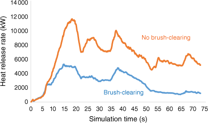
Overall, the results of the modelling run on brush-cleared vegetation showed fire behaviour less intense than when the fuel treatment was not implemented (up to 11 493 kW for the modality without brush-clearing vs 5020 kW with brush-clearing; case study Château C1, Fig. 4), however, with a similar fire HRR during the first 10–20 s (up to 40 s in the case Château C2; Supplementary Fig. S2) according to the study case.
|
Griffon
Post-fire damage assessment (Fig. 3a): only the windward house was severely burned (A1) and this building sheltered the neighbouring house (B), which was undamaged, from the fire. The facades exposed to the fire (A1) were the most damaged (window with broken glass allowing the fire to impact the inside), mostly because the ornamental hedge (D) nearby acted as a vector for fire propagation. The southern hedge (C) was burned by a surface fire fuelled by the brush-clearing residues and spread the flame to the ornamental shrubs located in the garden nearby.
Modelling: during the first part of the simulation, flames propagated further in the brush-cleared modality because the trees were more scattered (low tree density; Table 2) (Fig. 5) and possibly because of the tilt angle between the flame and the slope located between the forest and the garden, especially to the south of the domain. Beyond 20 s of simulation, when the vegetation was brush-cleared and composed mostly of grass (that could be mown lawn in the HIZ), it burned very rapidly (less than 15 s) without fire spread to low tree branches. In contrast, in the scenario without brush-clearing, the fire could propagate vertically into the tree canopy, intensifying the damage caused by the fire to vegetation (Supplementary Video S1).

|
Quantitatively, this differing behaviour between both modalities can be also found with the ROS inferred from the mass loss maps: without brush-clearing, values were approximately 3 m s−1 (between 10 and 20 s of simulation) and 1.5 m s−1 (between 20 and 30 s), whereas with brush-clearing, the ROS increased to values respectively of 4 and 2.5 m s−1.
Barnouins
Post-fire damage assessment: the fire propagated uphill in the brush-cleared vegetation towards the house (slope of ~50%), the damage was mostly due to a windward window that had been left open, allowing the firebands generated by the pine stand downhill to enter the building and set it on fire; then, the fire spread outside through the windows on the left side of the house. A large part of the windward ornamental vegetation located on this side was also impacted (Fig. 3b). The vegetation located on the leeward side of the house was not affected.
Modelling: besides the lower HRR in the modality with brush-clearing during the simulation, we found that, regarding the fire front position (Fig. 6), after the first 15 s of simulation, the flames were more scattered in the scenario with brush-clearing, especially at T0 (T0: simulation start) + 50 and T0 + 65 s (Supplementary Video S2). In the scenario without brush-clearing, the tree canopy burned, involving higher tree mass loss (Supplementary Fig. S3). This was largely due to the fact that the HIZ contained no trees in the modality with brush-clearing and had only grass vegetation, whereas shrubs and trees were present in the modality without brush-clearing. In contrast, the mass loss did not differ between both modalities regarding the ornamental vegetation (Supplementary Fig. S4). The vegetation on the leeward side of the house was partly burned only when the house was not an obstacle between the vegetation and the fire downslope, regardless of the fuel management. Without brush-clearing, the ROS measured on the mass loss map showed a value of 7 m s−1, this unrealistically high value being due to the assumption of low FMC used in the modelling. The ROS in the modality with brush-clearing could not be assessed because fire propagation in grass only in the HIZ was much too scattered to allow identification of where the front position was located. This could be due to the fact that the fire front was not a clear line but rather patches of grass that ignited here and there.

|
Flux sensors located at different heights on the house windward facade, in both modalities, were quickly reached by the flames and intensities of total heat flux higher than 80 kW m−2 were recorded (Fig. 7). The much lower values obtained for the radiative heat flux (up to 16–18 kW m−2 according to the fuel treatment modality) compared with those obtained for the total heat flux showed that the convective heat flux (difference between the total and the radiative heat flux) was higher than the radiative heat flux. The heat sensor positioned the highest (13 m) was the most affected by the wind gusts (highest values of total heat flux).

|
Château
Post-fire damage assessment C1: in this case, the fire propagated from the NNW to the SSE, first in untreated wildland vegetation (stand of Pinus halepensis Mill., 1768) and then reached the tall northern hedge of cypress (Cupressus sempervirens L., 1753) located to the south of the southwerstern building that completely burned (Fig. 3c).
Modelling: in the modality with brush-clearing, the fire propagated less intensely (HRR on average 2.4 times lower than without vegetation management; see Fig. 4), limiting the spread on the flanks, therefore avoiding the cypress hedge and the other trees around the building (Fig. 8). This was due to two main factors: (i) a lower intensity in all of the vegetation strata in the modelling and (ii) stronger wind (20% higher) in the HIZ in the scenario with brush-clearing because the trees were more scattered (Table 2). In contrast, without brush-clearing, corresponding to the actual situation during the fire, the hedge partially burned. The ROS estimates were found to be quite close in both modalities, at a value of ~4 m s−1 when the wind was higher (between 10 and 20 s of simulation).

|
Post-fire damage assessment C2: in this case, fire behaviour was assessed when the flame front, spreading through the unmanaged pine stand, reached the building to the north. The tall pine (11 m) located close to the building (and overhanging the roof) completely burned, contributing to the building destruction (Fig. 3c).
Modelling: beyond the first 40 s of simulation with brush-clearing (Fig. 9), the fire spread in the pine stand and in the brush-cleared area but with decreasing intensity when approaching the buildings (HRR of 14 100 kW at 40 s down to 10 900 kW at 50 s; Supplementary Fig. S2). After 45 s, the tall pine was reached by the fire in both modalities but burned more intensely (tree totally burned) without brush-clearing (on average, HRR 1.42 times higher; see Supplementary Fig. S2), agreeing with the post-fire damage assessment. The ROS in the modalities with and without brush-clearing reached 5 and 6 m s−1 respectively.

|
Post-fire damage assessment C3: in this case, three tall trees, a cedar (Cedrus atlantica (Manetti ex Endl.) Carrière, 1855), a palm tree (Phoenix canariensis Hort. ex Chabaud, 1882) and a linden tree (Tilia europea L., 1753), located close to the southernmost building (and partially overhanging the roof) were impacted by the fire (the two former trees mostly or totally burned while the latter was heavily scorched), contributing to the building destruction. The southern cypress hedge also burned as well as the neighbouring trees (Fig. 3c).
Modelling: the simulation presenting fire propagation due to firebrands showed that the fire could ignite the tree canopy and spread progressively towards the ground (Fig. 10), then igniting the lower branches and vegetation nearby (Supplementary Video S3). This was possible owing to local wind currents of different directions generated by obstacles nearby (buildings, trees, etc.) during wind gusts (i.e. 11.7 m s−1). This result was not observed in the post-fire survey, especially for the linden, possibly because this tree’s moisture content was higher than in the modelling. The simulation presenting the fire propagation involving the cypress hedge located to the north showed that the tall cedar burned (Fig. 11). After some time (180 s), the fire reached the side of the building where the linden tree was located, but was not powerful enough to cause its ignition while, between 80 and 130 s, the fire ignited the southern cypress hedge, possibly because the canopy was lower and therefore more easily reached by the flame.

|

|
Discussion
Comparing observed and numerical results of vegetation damage
Overall, the results of the simulations in terms of damage to ornamental vegetation were in agreement with the damage recorded post-fire. Numerical results showed a decrease in fire intensity in the modality with brush-clearing, in agreement with the commonly agreed effect of brush-clearing. Moreover, these results revealed that, overall, fire spread was greater in the beginning of the simulation (corresponding to propagation in the native vegetation before reaching the garden) with brush-clearing. This was mostly due to the lower tree density used in this modality enhancing the wind effect on fire propagation. Pimont et al. (2011), using a coupled atmosphere wildfire behaviour model, HIGRAD/FIRETEC, found that the rate of spread was not strongly modified while a decrease in fire intensity occurred after several metres of propagation in the treated zone. In these authors’ work, only a reduction in the fuel canopy was modelled as vegetation treatment but the authors suggested that, if the surface fuel was also cleared, the increase in wind speed in channels was likely to increase the fire spread. In the current work, numerical ROS derived from the mass loss maps in each study case (highest values ranging from 3 to 7 m s−1) were higher than those reported by firefighters during the fire (between 1 and 1.5 m s−1, estimated as an average value over the entire Rognac Fire area). The assumption of low FMC in the simulation was clearly a large contributor to this overestimation.
In the study case Château C1, the scenario without brush-clearing (which was the case at the time of the fire) underestimated the fire effects on the hedge that did not totally burn a bit despite the low simulated FMC. In this case, ignition could have also been provoked or enhanced by the firebrand shower generated by the burning pine stand (both mechanisms highly likely to be in synergy). In the case of Château C2, the modality without brush-clearing, corresponding to the actual case, showed the same severe impact on the vegetation close to the building (e.g. the big pine) as observed post-fire. Regarding Château C3, for the scenario dealing with ignition by firebrands, the results of the simulation overestimated the impact on the linden tree (though the impact on the cedar was correctly modelled) with the total burning of the tree while the post-fire damage observed on this tree showed a lesser impact (the canopy was only scorched) than for the cedar (which was totally burned). This could be due to the low FMC used in the simulation. In contrast, for the scenario dealing with ignition from the northern cypress hedge, the results of the simulation matched the post-fire damage observed, with the linden tree lightly impacted, even with a simulated FMC lower than during the fire. This was mostly due to the longer time required by the fire to spread to this tree. However, synergy with the firebrand shower is likely to have impacted the building and the vegetation. Indeed, conifers like Pinus halepensis are among the best firebrand generators (Ganteaume et al. 2011) in the Mediterranean basin, and the native vegetation burned in this study case was dominated by this species (and some big pines were very close to the building).
In the study case Barnouins, numerical results showed that, regardless of the fuel treatment scenario, ornamental vegetation and structures would have been impacted by the fire, despite the lower HRR during the simulation with brush-clearing. This was in agreement with the post-fire damage to the ornamental vegetation.
In the study case Griffon, both simulated results and post-fire damage survey showed that the damaged house and garden were fully exposed to fire owing to the continuity from the natural to the ornamental vegetation (involving mostly hedges) while the neighbouring house was undamaged, mostly because this house was sheltered from the fire by the damaged building, the fire front coming from the NW. This result is in agreement with the work of Fernandez et al. (2018) that used the raster-based model SWIFFT on the same study case.
Impact of the fuel reduction regulations (mandatory brush-clearing) on fire behaviour
Fuel management, including fuel reduction, with or without segregation of pockets of fuel, is frequently used to reduce fire intensity and crowning (Xanthopoulos et al. 2006; Finney et al. 2007). Physics-based modelling studies have been used to assess fire propagation in various fuel treatments, taking into account or not the wind effect (Dupuy and Morvan 2005; Linn et al. 2005; Pimont et al. 2006, 2011; Parsons 2007) and usually showing the mitigation of fire behaviour in the treated areas. For instance, Pimont et al. (2014) mentioned that a cleared distance of 50 m was appropriate (90 and 95% reduction of radiant flux reduction observed at 50 m compared with the forest edge) in their tested conditions, for both thermal radiation and gas temperature. The current work confirmed the utmost importance of enforcing the regulations relating to fuel reduction, including the distance between tree crowns and buildings.
Vegetation management around housing, along with the location and arrangement of structures at the WUI, have been found equally important as, if not more than building construction. In the Griffon study case, brush-clearing had been carried out before the fire; however, plant residues had not been removed from below the trees, which counteracted the effect of this measure, highlighting the importance of clearing the residues after treatment. Indeed, the scenario with brush-clearing, i.e. without vegetation residue, showed that the fire intensity would have strongly decreased. Moreover, it was already noted in a previous study that, even when the buffer area around a building had been cleared very recently, some fuels and remaining litter could spread the fire to the building (Pimont et al. 2014). In the cases Château C1 and C2, regarding the modality with brush-clearing, the fire impact on the ornamental vegetation was low, highlighting the importance of mandatory fuel treatment aiming at the reduction of fuel biomass and continuity, especially in the area subject to the dominant wind, and therefore to the fire.
In contrast, in the Barnouins study case, the peak values of the numerical heat fluxes were of the same order regardless of the fuel treatment scenario, showing, first, that the contribution from the vegetation was significant, even if the highest values occurred over a shorter time when the vegetation was brush-cleared. Secondly, in this case study, the combination of two important factors (terrain and wind) driving the fire behaviour allowed the limits of mandatory brush-clearing to be reached. This showed that the area treated should have been extended beyond the mandatory 50-m brush-clearing to 100 m as is the case in specific locations (according to municipal decree). However, Syphard et al. (2013) showed that, even if structures were more likely to survive a fire with defensible space immediately adjacent to them, the most effective treatment distance varied between 5 and 20 m from the structure, but distances larger than 30 m did not provide additional protection, even for structures located on steep slopes. Moreover, the numerical results of heat fluxes obtained in the Barnouins study case showed that convection was dominant over radiation, in contrast to previous studies (e.g. Silvani and Morandini 2009; Terrei et al. 2019). This could be due to the high slope which favoured the impact of the hot gases. As the model took into account a slope of only 27% whereas in situ the slope value was 51%, the convective part would even have been higher in reality. The highest total heat fluxes occurred at 13-m height on the building side exposed to the fire front, even in the modality with brush-clearing (which corresponded to the actual case). It was therefore possible that, even if the window had been closed, the brush-cleared vegetation located on the steep slope combined with the strong wind could have caused the breaking of the window pane and therefore fire propagation into the house.
Computational modelling as well as laboratory and field experiments describing the heat transfer required for ignition have shown that the high flames of intensely burning shrubs and tree canopies (crown fires) must be within 30 m to ignite a home’s wooden exterior (Cohen 1995, 2000, 2004; Cohen and Wilson 1995; Cohen and Butler 1998), but this is not the case in France. A previous study also showed that the location and arrangement of the home can override the protective benefits of fire-safe structure design (Syphard et al. 2017). The distance between the building and tree canopy is at least 3 m in the French regulations and therefore without a canopy overhanging the roof. This distance could be underestimated in the case of synergy between slope and wind (as simulated in the Barnouins study case) and should be increased according to terrain conditions (along with the radius of mandatory brush-clearing). Previous work also suggested that, in addition to treatment at the house level, an overlapping community protection zone (a little less than 500 m wide under deleterious conditions) could provide opportunities for firefighters to protect other flammable features of a community (Nowicki 2002). It is worth noting that Syphard et al. (2012), using an extensive geographic dataset of structure locations that were destroyed or damaged by wildfires since 2001 in southern California, found that rates of structure loss were higher when they were surrounded by wildland vegetation, but were generally higher in herbaceous fuel types than in higher fuel-volume woody types.
Functional capacity of FDS to model WUI fire behaviour using refined vegetation data
Previous studies on fire behaviour modelling concentrated on ecosystems that were very different from Mediterranean forest ecosystems, especially from those found at the WUI. Among the closest systems studied, Mediterranean shrubs and grasslands have been experimentally (Morandini et al. 2006; Santoni et al. 2006) and numerically studied (Morvan and Dupuy 2004; Mell et al. 2007; Morvan et al. 2009), however without tackling the issue of the crown fire propagation, except in the work of Pimont et al. (2011), for instance. Numerically, the complexity of models varied (Novozhilov et al. 1996; Plourde et al. 1997; Morvan and Dupuy 2001; Mell et al. 2009; Pimont et al. 2011, 2014) but using rather simplified vegetation inputs (involving generally one or two species). In contrast, the added value of the current work was the consideration in the modelling of the characteristics of most species (native as well as exotic and orchard species) and the georeferencing of the main components of the WUI vegetation recorded in each study case. This allowed the mapping of an accurate vegetation distribution (i.e. reflecting well the pre-fire vegetation). This helped to pinpoint the easy fire propagation in the Cupressus sempervirens hedge, due to both fuel continuity and high combustibility (high amount of dead fuel within this species’ canopy; Ganteaume et al. 2013b), as well as other highly flammable conifer species such as Pinus halepensis and Cedrus atlantica compared with rather less flammable deciduous species (such as the linden tree, Tilia europea). The use of deleterious species combined with the unwise location of these species (e.g. overhanging a roof) certainly worsened the level of damage to buildings and the unwise structure of some of these species (cypress hedge) could also increase fire propagation. Firewise landscaping should avoid planting deleterious species, especially with such structure patterns, close to structures (Ganteaume 2019).
Using species generating firebrands is also an issue at the WUI, not to mention natural pine stands being among the best firebrand emitters. Besides the damage that firebrands could produce in vegetation and structures, it is important that the fire behaviour models include propagation by embers, along with the advancing flame font, as ember transport can be critical to the simulation of past fire spread. Without their inclusion in the model, the simulation of fire spread could be shortened, especially depending on the terrain (Pugnet et al. 2013).
Conclusions
This work consisted in implementing the CFD model FDS on three different study cases impacted by a past fire in the south-east of France (Rognac Fire 2016) and comparing the results with the post-fire damage on vegetation recorded in the field. For each case, two scenarios of vegetation management were tested (brush-clearing vs no brush-clearing). Numerical results mostly agreed with the post-fire survey and underlined once more the relevance of fuel reduction measures in terms of fire mitigation. In some cases, they highlighted the necessity to strengthen these regulations according to slope and wind conditions.
This work also proved the functional capacities of the model used to assess fire behaviour at the WUI scale, taking into account accurate vegetation distribution, despite the bias inherent in the model, mainly regarding the simulated FMC, which was lower than in the field. Indeed, the FMC has a very important role in plant flammability, both in experiments and CFD modelling (Bufacchi et al. 2016). Research has also shown that modelling burning vegetation that has high moisture content can distance the results from reality (El Houssami et al. 2016). In the current work, arbitrary FMC values lower than 25% were chosen to avoid this problem, along with the difficulty of igniting the vegetation canopy in some cases, according to the work of Terrei et al. (2019). This hypothesis is common to all of the calculation codes (e.g. SWIFFT, WFDS) and cannot be by-passed with the current state of knowledge.
Supplementary material
Supplementary material is available online.
Data availability
Data for this manuscript are accessible at: DOI 10.5281/zenodo.7445894.
Conflicts of interest
The authors declare that they have no conflicts of interest.
Declaration of funding
This work was funded by the French Ministry of Environment (Ministère de la Transition Ecologique, SRNH/DGPR) and by the Interreg program Marittimo InterMed IT-FR Maritime.
Acknowledgements
The authors thank Inrae technical staff for the help in the vegetation and damage surveys.
References
Blanchi R, Leonard J (2005) Investigation of bushfire attack mechanisms resulting in house loss in the ACT bushfire 2003. (Bushfire Cooperative Research Centre (CRC) Report: Australia)Bufacchi P, Krieger GC, Mell W, Alvarado E, Santos JC, Carvalho JA (2016) Numerical simulation of surface forest fire in Brazilian Amazon. Fire Safety Journal 79, 44–56.
| Numerical simulation of surface forest fire in Brazilian Amazon.Crossref | GoogleScholarGoogle Scholar |
Caton SE, Hakes RSP, Gorham DJ, Zhou A, Gollner MJ (2017) Review of pathways for building fire spread in the wildland urban interface part i: exposure conditions. Fire Technology 53, 429–473.
| Review of pathways for building fire spread in the wildland urban interface part i: exposure conditions.Crossref | GoogleScholarGoogle Scholar |
Code forestier (2022) Section 3: Débroussaillement (Articles L131-10 à L131-16) - Légifrance (legifrance.gouv.fr). [In French] Available at https://legifrance.gouv.fr/codes/id/LEGISCTA000025248647/ [24 August 2022]
Cohen J (2000) Preventing disaster: Home ignitability in the wildland-urban interface. Journal of Forestry 98, 15–21.
| Preventing disaster: Home ignitability in the wildland-urban interface.Crossref | GoogleScholarGoogle Scholar |
Cohen J (2008) The wildland-urban interface fire problem: A consequence of the fire exclusion paradigm. Forest History Today Fall, 20–26.
Cohen JD (1995) Structure ignition assessment model (SIAM). In ‘Proceedings Biswell Symposium: Fire Issues and Solutions in Urban Interface and Wildland Ecosystems’, 15–17 February 1994, Walnut Creek, CA. General Technical Report PSW 158, pp. 85–92. (USDA Forest Service)
Cohen JD (2004) Relating flame radiation to home ignition using modeling and experimental crown fires. Canadian Journal of Forest Research 34, 1616–1626.
| Relating flame radiation to home ignition using modeling and experimental crown fires.Crossref | GoogleScholarGoogle Scholar |
Cohen JD, Butler BW (1998) Modeling potential structure ignitions from flame radiation exposure with implications for wildland/urban interface fire management. In ‘Proceedings of the 13th Fire and Forest Meteorology Conference’, pp. 81–86. (International Association of Wildland Fire) Available at https://www.fs.usda.gov/research/treesearch/4687
Cohen JD, Wilson P (1995) Current results from structure ignition assessment model (SIAM) research. In ‘Proceedings of the Fire Management in the Wildland/Urban Interface: Sharing solutions Symposium’, 2–5 October 1994, Kananaskis, AB. (Ed. C Tymstra) pp. 120–132. (Partners in Protection: Edmonton, AB)
De Gennaro M, Billaud Y, Pizzo Y, Garivait S, Loraud J-C, El Hajj M, Porterie B (2017) Real-time wildland fire spread modeling using tabulated flame properties. Fire Safety Journal 91, 872–881.
| Real-time wildland fire spread modeling using tabulated flame properties.Crossref | GoogleScholarGoogle Scholar |
Dupuy J-L, Morvan D (2005) Numerical study of a crown fire spreading toward a fuel break using a multiphase physical model. International Journal of Wildland Fire 14, 141–151.
| Numerical study of a crown fire spreading toward a fuel break using a multiphase physical model.Crossref | GoogleScholarGoogle Scholar |
Dupuy J-L, Linn RR, Konovalov V, Pimont F, Vega JA, Jiménez E (2011) Exploring three-dimensional coupled fire–atmosphere interactions downwind of wind-driven surface fires and their influence on backfires using the HIGRAD-FIRETEC model. International Journal of Wildland Fire 20, 734–750.
| Exploring three-dimensional coupled fire–atmosphere interactions downwind of wind-driven surface fires and their influence on backfires using the HIGRAD-FIRETEC model.Crossref | GoogleScholarGoogle Scholar |
El Houssami M, Thomas JC, Lamorlette A, Morvan D, Chaos M, Hadden R, Simeoni A (2016) Experimental and numerical studies characterizing the burning dynamics of wildland fuels. Combustion and Flame 168, 113–126.
| Experimental and numerical studies characterizing the burning dynamics of wildland fuels.Crossref | GoogleScholarGoogle Scholar |
Fernandez F, Guillaume B, Porterie B, Ganteaume A, Guerra F (2018) Modelling fire spread and damage in wildland-urban interfaces. In ‘VIII International Conference on Forest Fire Research’, 12–16 November 2018, Coimbra, Portugal. (Ed. DX Viegas) pp. 818–825. (Univ Coimbra)
Finney MA, Seli RC, McHugh CW, Ager AA, Bahro B, Agee JK (2007) Simulation of long-term landscape-level fuel treatment effects on large wildfires. International Journal of Wildland Fire 16, 712–727.
| Simulation of long-term landscape-level fuel treatment effects on large wildfires.Crossref | GoogleScholarGoogle Scholar |
Fox DM, Martin N, Carrega P, Andrieu J, Adnès C, Emsellem K, Ganga O, Moebius F, Tortorollo N, Fox EA (2015) Increases in fire risk due to warmer summer temperatures and wildland urban interface changes do not necessarily lead to more fires. Applied Geography 56, 1–12.
| Increases in fire risk due to warmer summer temperatures and wildland urban interface changes do not necessarily lead to more fires.Crossref | GoogleScholarGoogle Scholar |
Ganteaume A (2018) Does plant flammability differ between leaf and litter bed scale? Role of fuel characteristics and consequences for flammability assessment. International Journal of Wildland Fire 27, 342–352.
| Does plant flammability differ between leaf and litter bed scale? Role of fuel characteristics and consequences for flammability assessment.Crossref | GoogleScholarGoogle Scholar |
Ganteaume A (2019) Ornamental Vegetation. In ‘Encyclopedia of wildfires and wildland–urban interface (WUI) Fires’. (Ed. S Manzello) pp. 816–823 (Springer: Cham)
| Crossref |
Ganteaume A, Guijarro M, Jappiot M, Hernando C, Lampin-Maillet C, Pérez-Gorostiaga P, Vega JA (2011) Laboratory characterization of firebrands involved in spot fires. Annals of Forest Science 68, 531–541.
| Laboratory characterization of firebrands involved in spot fires.Crossref | GoogleScholarGoogle Scholar |
Ganteaume A, Jappiot M, Lampin-Maillet C (2013a) Assessing the flammability of surface fuels beneath ornamental vegetation in wildland–urban interfaces in Provence (south-eastern France). International Journal of Wildland Fire 22, 333–342.
| Assessing the flammability of surface fuels beneath ornamental vegetation in wildland–urban interfaces in Provence (south-eastern France).Crossref | GoogleScholarGoogle Scholar |
Ganteaume A, Jappiot M, Lampin C, Guijarro M, Hernando C (2013b) Flammability of some ornamental species in wildland–urban interfaces in southeastern France: Laboratory assessment at particle level. Environmental Management 52, 467–480.
| Flammability of some ornamental species in wildland–urban interfaces in southeastern France: Laboratory assessment at particle level.Crossref | GoogleScholarGoogle Scholar |
Ganteaume A, Barbero R, Jappiot M, Maillé E (2021) Understanding future changes to fires in southern Europe and their impacts on the wildland–urban interface. Journal of Safety Science and Resilience 2, 20–29.
| Understanding future changes to fires in southern Europe and their impacts on the wildland–urban interface.Crossref | GoogleScholarGoogle Scholar |
Ghaderi M, Ghodrat M, Sharples JJ (2021) LES simulation of wind-driven wildfire interaction with idealized structures in the wildland–urban interface. Atmosphere 12, 21
| LES simulation of wind-driven wildfire interaction with idealized structures in the wildland–urban interface.Crossref | GoogleScholarGoogle Scholar |
Grishin A (1997) ‘Mathematical modeling of forest fires and new methods of fighting them.’ (Tomsk State University: Tomsk, Russia)
Hakes RSP, Caton SE, Gorham DJ, Gollner MJ (2017) A review of pathways for building fire spread in the wildland–urban interface Part II: response of components and systems and mitigation strategies in the United States. Fire Technology 53, 475–515.
| A review of pathways for building fire spread in the wildland–urban interface Part II: response of components and systems and mitigation strategies in the United States.Crossref | GoogleScholarGoogle Scholar |
Instruction techniques sur les obligations légales de débroussaillement (2019) Légifrance - Droit national en vigueur - Circulaires et instructions - Obligations légales de débroussaillement (legifrance.gouv.fr). [In French] Available at https://www.legifrance.gouv.fr/download/pdf/circ?id=44405 [24 August 2022]
Jiang W, Wang F, Fang L, Zheng X, Qiao X, Li Z, Meng Q (2021) Modelling of wildland–urban interface fire spread with the heterogeneous cellular automata model. Environmental Modelling & Software 135, 104895
| Modelling of wildland–urban interface fire spread with the heterogeneous cellular automata model.Crossref | GoogleScholarGoogle Scholar |
Jones GM, Gutiérrez RJ, Tempel DJ, Whitmore SA, Berigan WJ, Peery MZ (2016) Megafires: an emerging threat to old-forest species. Frontiers in Ecology and the Environment 14, 300–306.
| Megafires: an emerging threat to old-forest species.Crossref | GoogleScholarGoogle Scholar |
Linn R, Winterkamp J, Colman JJ, Edminster C, Bailey JD (2005) Modeling interactions between fire and atmosphere in discrete element fuel beds. International Journal of Wildland Fire 14, 37–48.
| Modeling interactions between fire and atmosphere in discrete element fuel beds.Crossref | GoogleScholarGoogle Scholar |
Linn RR, Cunningham P (2005) Numerical simulations of grass fires using a coupled atmosphere–fire model: basic fire behavior and dependence on wind speed. Journal of Geophysical Research: Atmospheres 110, D13107
| Numerical simulations of grass fires using a coupled atmosphere–fire model: basic fire behavior and dependence on wind speed.Crossref | GoogleScholarGoogle Scholar |
Maditinos Z, Vassiliadis C (2011) Mega fires: can they be managed effectively? Disaster Prevention and Management 20, 41–52.
| Mega fires: can they be managed effectively?Crossref | GoogleScholarGoogle Scholar |
Manzello SL, Suzuki S, Gollner MJ, Fernandez-Pello AC (2020) Role of firebrand combustion in large outdoor fire spread. Progress in Energy and Combustion Science 76, 100801
| Role of firebrand combustion in large outdoor fire spread.Crossref | GoogleScholarGoogle Scholar |
Maranghides A, Mell W (2011) A case study of a community affected by the Witch and Guejito wildland fires. Fire Technology 47, 379–420.
| A case study of a community affected by the Witch and Guejito wildland fires.Crossref | GoogleScholarGoogle Scholar |
McGrattan K, Hostikka S, McDermott R, Floyd J, Weinschenk C, Overholt K (2013) Fire Dynamics Simulator user’s guide. Technical Report NIST Special Publication 1019–6. (National Institute of Standards and Technology: Gaithersburg, MD, USA)
Mell W, Jenkins MA, Gould J, Cheney P (2007) A physics-based approach to modelling grassland fires. International Journal of Wildland fire 16, 1–22.
| A physics-based approach to modelling grassland fires.Crossref | GoogleScholarGoogle Scholar |
Mell W, Maranghides A, McDermott R, Manzello SL (2009) Numerical simulation and experiments of burning Douglas fir trees. Combustion and Flame 156, 2023–2041.
| Numerical simulation and experiments of burning Douglas fir trees.Crossref | GoogleScholarGoogle Scholar |
Mell WE, Manzello SL, Maranghides A, Butry D, Rehm RG (2010) The wildland–urban interface fire problem – current approaches and research needs. International Journal of Wildland Fire 19, 238–251.
| The wildland–urban interface fire problem – current approaches and research needs.Crossref | GoogleScholarGoogle Scholar |
Morandini F, Silvani X, Rossi L, Santoni P-A, Simeoni A, Balbi JH, Rossi JL, Marcelli T (2006) Fire spread experiment across Mediterranean shrub: influence of wind on flame front properties. Fire Safety Journal 41, 229–235.
| Fire spread experiment across Mediterranean shrub: influence of wind on flame front properties.Crossref | GoogleScholarGoogle Scholar |
Morandini F, Santoni PA, Tramoni JB, Mell WE (2019) Experimental investigation of flammability and numerical study of combustion of shrub of rockrose under severe drought conditions. Fire Safety Journal 108, 102836
| Experimental investigation of flammability and numerical study of combustion of shrub of rockrose under severe drought conditions.Crossref | GoogleScholarGoogle Scholar |
Morvan D, Dupuy JL (2001) Modeling of fire spread through a forest fuel bed using a multiphase formulation. Combustion and Flame 127, 1981–1994.
| Modeling of fire spread through a forest fuel bed using a multiphase formulation.Crossref | GoogleScholarGoogle Scholar |
Morvan D, Dupuy JL (2004) Modeling the propagation of a wildfire through a Mediterranean shrub using a multiphase formulation. Combustion and Flame 138, 199–210.
| Modeling the propagation of a wildfire through a Mediterranean shrub using a multiphase formulation.Crossref | GoogleScholarGoogle Scholar |
Morvan D, Méradji S, Accary G (2009) Physical modelling of fire spread in grasslands. Fire Safety Journal 44, 50–61.
| Physical modelling of fire spread in grasslands.Crossref | GoogleScholarGoogle Scholar |
Novozhilov V, Moghtaderi B, Fletcher DF, Kent JH (1996) Computational fluid dynamics modelling of wood combustion. Fire Safety Journal 27, 69–84.
| Computational fluid dynamics modelling of wood combustion.Crossref | GoogleScholarGoogle Scholar |
Nowicki B (2002) ‘The community protection zone: defending houses and communities from the threat of forest fire’. 8 pp. (Center for Biological Diversity: Tucson, AZ, USA) Available at https://www.biologicaldiversity.org/publications/papers/wui1.pdf
Parsons RA (2007) Spatial variability in forest fuels: simulation modeling and effects on fire behavior. PhD Thesis, University of Montana–Missoula, College of Forestry and Conservation, MT, USA. 255 pp.
Parsons RA, Mell WE, McCauley P (2011) Linking 3D spatial models of fuels and fire: effects of spatial heterogeneity on fire behavior. Ecological Modelling 222, 679–691.
| Linking 3D spatial models of fuels and fire: effects of spatial heterogeneity on fire behavior.Crossref | GoogleScholarGoogle Scholar |
Perez-Ramirez Y, Mell WE, Santoni PA, Tramoni J-B, Bosseur F (2017) Examination of WFDS in modeling spreading fires in a furniture calorimeter. Fire Technology 53, 1795–1832.
| Examination of WFDS in modeling spreading fires in a furniture calorimeter.Crossref | GoogleScholarGoogle Scholar |
Pimont F, Linn RR, Dupuy J-L, Morvan D (2006) Effects of vegetation description parameters on forest fire behavior with FIRETEC. Forest Ecology and Management 234 S, S120
| Effects of vegetation description parameters on forest fire behavior with FIRETEC.Crossref | GoogleScholarGoogle Scholar |
Pimont F, Dupuy J-L, Linn RR, Dupont S (2009) Validation of FIRETEC wind-flows over a canopy and a fuel-break. International Journal of Wildland Fire 18, 775–790.
| Validation of FIRETEC wind-flows over a canopy and a fuel-break.Crossref | GoogleScholarGoogle Scholar |
Pimont F, Dupuy JL, Linn RR, Dupont S (2011) Impacts of tree canopy structure on wind flows and fire propagation simulated with FIRETEC. Annals of Forest Science 68, 523–530.
| Impacts of tree canopy structure on wind flows and fire propagation simulated with FIRETEC.Crossref | GoogleScholarGoogle Scholar |
Pimont F, Dupuy J-L, Linn RR (2014) Chapter 3: Fire management. In ‘Advances in forest fire research’. (Ed. DX Viegas) pp. 749–758. (Coimbra University Press: Coimbra)
Plourde F, Doan-Kim S, Dumas J-C, Malet J-C (1997) A new model of wildland fire simulation. Fire Safety Journal 29, 283–299.
| A new model of wildland fire simulation.Crossref | GoogleScholarGoogle Scholar |
Pugnet L, Chong D, Duff T, Tolhurst (2013) Wildland–urban interface (WUI) fire modelling using PHOENIX Rapidfire: A case study in Cavaillon, France. In ‘MODSIM2013, 20th International Congress on Modelling and Simulation’, December 2013. (Eds J Piantadosi, R Anderssen, J Boland) pp. 228–234. (Modelling and Simulation Society of Australia and New Zealand)
Rehm RG, Evans DD (2013) Physics-based modeling of wildland-urban interface fires. In ‘Remote Sensing and Modeling Applications to Wildland Fires’. (Eds JJ Qu, WT Sommers, R Yang, AR Riebau) pp. 227–236. (Springer: Heidelberg, Berlin)
Santoni P-A, Simeoni A, Rossi J-L, Bosseur F, Morandini F, Silvani X, Balbi J-H, Cancellieri D, Rossi L (2006) Instrumentation of wildland fire: characterisation of a fire spreading through a Mediterranean shrub. Fire Safety Journal 41, 171–184.
| Instrumentation of wildland fire: characterisation of a fire spreading through a Mediterranean shrub.Crossref | GoogleScholarGoogle Scholar |
Silvani X, Morandini F (2009) Fire spread experiments in the field: temperature and heat fluxes measurements. Fire Safety Journal 44, 279–285.
| Fire spread experiments in the field: temperature and heat fluxes measurements.Crossref | GoogleScholarGoogle Scholar |
Sullivan A (2009) Wildland surface fire spread modelling, 1990–2007. 1: Physical and quasi-physical models. International Journal of Wildland Fire 18, 349–368.
| Wildland surface fire spread modelling, 1990–2007. 1: Physical and quasi-physical models.Crossref | GoogleScholarGoogle Scholar |
Syphard AD, Keeley JE, Massada AB, Brennan TJ, Radeloff VC (2012) Housing arrangement and location determine the likelihood of housing loss due to wildfire. PLoS One 7, e33954
| Housing arrangement and location determine the likelihood of housing loss due to wildfire.Crossref | GoogleScholarGoogle Scholar |
Syphard AD, Bar Massada A, Butsic V, Keeley JE (2013) Land use planning and wildfire: development policies influence future probability of housing loss. PLoS One 8, e71708
| Land use planning and wildfire: development policies influence future probability of housing loss.Crossref | GoogleScholarGoogle Scholar |
Syphard AD, Brennan TJ, Keeley JE (2017) The importance of building construction materials relative to other factors affecting structure survival during wildfire. International Journal of Disaster Risk Reduction 21, 140–147.
| The importance of building construction materials relative to other factors affecting structure survival during wildfire.Crossref | GoogleScholarGoogle Scholar |
Syphard AD, Rustigian-Romsos H, Mann M, Conlisk E, Moritz MA, Ackerly D (2019) The relative influence of climate and housing development on current and projected future fire patterns and structure loss across three California landscapes. Global Environmental Change 56, 41–55.
| The relative influence of climate and housing development on current and projected future fire patterns and structure loss across three California landscapes.Crossref | GoogleScholarGoogle Scholar |
Terrei L, Lamorlette A, Ganteaume A (2019) Modelling the fire propagation from the fuel bed to the lower canopy of ornamental species used in wildland–urban interfaces. International Journal of Wildland Fire 28, 113–116.
| Modelling the fire propagation from the fuel bed to the lower canopy of ornamental species used in wildland–urban interfaces.Crossref | GoogleScholarGoogle Scholar |
Thomas JC, Mueller EV, Gallagher MR, Clark KL, Skowronski N, Simeoni A, Hadden RM (2021) Coupled assessment of fire behavior and firebrand dynamics. Frontiers in Mechanical Engineering 7, 650580
| Coupled assessment of fire behavior and firebrand dynamics.Crossref | GoogleScholarGoogle Scholar |
Vanella M, McGrattan K, McDermott R, Forney G, Mell W, Gissi E, Fiorucci P (2021) A multi-fidelity framework for wildland fire behavior simulations over complex terrain. Atmosphere 12, 273
| A multi-fidelity framework for wildland fire behavior simulations over complex terrain.Crossref | GoogleScholarGoogle Scholar |
Xanthopoulos G, Caballero D, Galante M, Alexandrian D, Rigolot E, Marzano R (2006) Forest fuel management in Europe. In ‘Fuels Management-How to Measure Success: Conference Proceedings’, 28–30 March 2006, Portland, OR. (Eds PL Andrews, BW Butler comps.) Proceedings RMRS-P-41. (USDA Forest Service, Rocky Mountain Research Station: Fort Collins, CO)