

Post-wildfire contamination of soils and sediments by polycyclic aromatic hydrocarbons in north-central British Columbia, Canada
K. A. Kieta A * , P. N. Owens B and E. L. Petticrew B
A Natural Resources and Environmental Studies Program, University of Northern British Columbia, Prince George, BC, Canada.
B Department of Geography, Earth and Environmental Sciences, University of Northern British Columbia, Prince George, BC, Canada.
International Journal of Wildland Fire 32(7) 1071-1088 https://doi.org/10.1071/WF22211
Submitted: 19 October 2022 Accepted: 3 May 2023 Published: 13 June 2023
© 2023 The Author(s) (or their employer(s)). Published by CSIRO Publishing on behalf of IAWF. This is an open access article distributed under the Creative Commons Attribution-NonCommercial-NoDerivatives 4.0 International License (CC BY-NC-ND)
Abstract
Background: The Nechako River Basin (NRB) is a large, regulated basin in north-central British Columbia, Canada that has been impacted by numerous landscape disturbances, including a severe wildfire in 2018.
Aims: The aims of this study were to quantify the post-wildfire temporal and spatial extent of contamination by polycyclic aromatic hydrocarbons (PAHs) of both soils and riverine sediments, and to identify the primary sources of PAHs in the watershed.
Methods: Soil samples were collected at burned and unburned sites in 2018 and at the burned sites in 2020 and 2021. Sediment samples were collected at three tributaries impacted by wildfire and three Nechako River mainstem (i.e. main channel) sites from 2018 to 2021. Samples were analysed for parent PAHs.
Key results: PAH concentrations decreased in soil samples from 2018 to 2021 but are not below the concentrations found in unburned samples. Tributary sediment samples showed higher concentrations immediately post-fire relative to the mainstem Nechako River, but in the years since, that trend has reversed.
Conclusions: PAHs persist in terrestrial and aquatic environments for years following wildfire, but at concentrations below various quality guidelines. PAHs were primarily derived from the wildfires, with some mixed sources at the downstream sites.
Implications: Wildfires are an important source of environmental contamination of terrestrial and aquatic environments.
Keywords: Nechako River Basin, polycyclic aromatic hydrocarbons, post-wildfire contamination, regional scale, soils, soil pollutants, suspended sediment, water pollutants, water quality, watershed.
Introduction
Wildfire is critical to the functioning and succession of many ecosystems throughout the world. In North America, fires have been increasing in size and frequency from 2000 to 2009 compared with previous decades (Iglesias et al. 2022), which can have negative impacts on terrestrial and aquatic environments (Samanta et al. 2002; Abdel-Shafy and Mansour 2016; Marvin et al. 2021). Wildfire causes physical, biological and chemical changes in soils, including changes in soil stability (Mataix-Solera et al. 2011; Thomaz 2017), changes in the microbial community (Hernández et al. 1997; Köster et al. 2021) and changes in macronutrients (Weston and Attiwill 1990; Driscoll et al. 1999; Ketterings and Bigham 2000). Additionally, when wildfire burns organic matter, it can create a gaseous layer that follows a temperature gradient to the deeper layers of soils and condenses onto soil aggregates and large grains, creating a water repellent soil layer that can exacerbate runoff and erosion (Doerr et al. 1996; Huffman et al. 2001). Although debris flows and landslides are not uncommon (Cannon and Gartner 2005; Kean et al. 2011; Jordan 2016; Kampf et al. 2016), even smaller scale erosion is detrimental. This movement of soils and sediments into the aquatic environment is problematic because it can cause issues that affect the health of aquatic organisms, such as increased turbidity and sedimentation of spawning habitat (McAdam et al. 2005; Jensen et al. 2009; Franssen et al. 2014), and also because sediment often carries pollutants with it such as heavy metals, excess nutrients and organic compounds such as polychlorinated biphenyls (PCBs), per- and polyfluoroalkyl substances (PFAS) and polycyclic aromatic hydrocarbons (PAHs) among others (Owens et al. 2005; Bilotta and Brazier 2008; Taylor and Owens 2009; Pulster et al. 2022).
PAHs are created during the combustion of organic matter and are often defined as either petrogenic or pyrogenic in origin (Nam et al. 2003; Masih and Taneja 2006). Petrogenic PAHs are produced in the form of natural hydrocarbons such as coal, oil and gas, whereas pyrogenic PAHs are produced from the combustion of organic materials including fossil fuels, vegetation and soil organic matter (Freeman and Cattell 1990; Baek et al. 1991; Zakaria et al. 2002; Zhang et al. 2008). There are hundreds of PAHs composed of a varying number of aromatic rings made up of carbon–hydrogen bonds that are then fused together by shared carbon atoms, which can affect their ability to break down in the environment due in part to differences in solubility and volatility (Pearlman et al. 1984; Baek et al. 1991; Achten and Andersson 2015). In general, PAHs are divided into low molecular weight (LMW) compounds, composed of two to three rings, and high molecular weight (HMW) compounds, composed of four or more rings. Several studies have shown that, as a group, LMW PAHs are found in greater abundance than HMW PAHs after wildfire (Gennadiev and Tsibart 2013; Chen et al. 2018; Rey‐Salgueiro et al. 2018), and that LMW PAHs are more abundant in the dissolved fraction compared with HMW PAHs, which are more abundant in the particulate fraction. However, numerous factors can impact PAH concentrations and the matrices in which they are found (Certini 2005; Yang et al. 2022).
Significant concentrations of PAHs have been found to be deposited in soils post-fire (Olivella et al. 2006; Campos et al. 2019), though the concentrations and species of PAHs vary depending on a range of factors including burn severity, vegetation type and antecedent soil conditions (Certini 2005; Rey‐Salgueiro et al. 2018). Campos et al. (2019) found elevated concentrations of PAHs in burned topsoil compared with unburned topsoil after a 5300 ha fire in Portugal, but the PAH concentrations had returned to baseline in just 4 months. Similar results were found in a study in South Korea, where PAH concentrations in topsoil had decreased significantly from their post-wildfire peak after just 5 months (Kim et al. 2011). Additionally, LMW PAHs were found in greater abundance in soils post-fire than HMW PAHs across a number of studies (Kim et al. 2011; Vergnoux et al. 2011; Simon et al. 2016; Rey‐Salgueiro et al. 2018), which is significant given the higher solubility of LMW PAHs and the well-documented increase in runoff and erosion following wildfire. Consequently, there is potential for PAHs to be transported to and through the aquatic environment (Campos and Abrantes 2021). This is important because at certain concentrations PAHs are known to be carcinogenic, toxic and mutagenic (Meador et al. 1995; Carls et al. 2008; Incardona 2017; Ainerua et al. 2020); therefore, specific PAHs are regulated in drinking water, soils and sediments (US EPA 1980; CCME 1999; WHO 2008). However, their production and mobilisation post-fire has been understudied (Kieta et al. 2023), with a few exceptions. In the Catalonia region of Spain, two studies of post-wildfire PAH contamination showed that the highest concentrations of HMW PAHs occur in sediments, whereas LMW PAHs dominate the dissolved phase (Olivella et al. 2006; Vila-Escalé et al. 2007).
Aquatic organisms are exposed to PAHs in two primary ways, the first being aqueous exposure through ventilation in the gills (Birdsall et al. 2001) and diffusion through skin (Landrum and Stubblefild 1991). The second, and potentially more important, is through burrowing in or ingesting sediments, which primarily applies to HMW PAHs due to their hydrophobicity and affinity to adsorb to sediment and organic matter (Leppänen and Kukkonen 2000; Wong et al. 2004; De La Torre-Roche et al. 2009; Hayakawa et al. 2019). Bilodeau et al. (2019) found that tadpoles accumulated greater concentrations of PAHs from sediment than from an aqueous source, and Kwok et al. (2013) found that biota–sediment accumulation factors of ƩPAHs in prey fish and shrimp taken from marshes in Hong Kong, China, were significantly higher than in studies of larger fish, likely due to the consumption of sediment by these organisms. With the acknowledgement that PAHs can be toxic to a wide range of aquatic organisms (Malcolm and Shore 2003; Wallace et al. 2020), determining PAH concentrations in soils and assessing if they are being transported to the aquatic environment and stored in sediment is important. This is even more essential in regions where there are sensitive species, some of which are already declining in population due to other pressures.
This research aims to determine the short- to medium-term impacts of severe wildfires with respect to concentrations of PAHs in soils and sediments in a large watershed in British Columbia, Canada. More specifically, the objectives were to determine: (1) the changes in PAH concentrations in soils and sediments for multiple years after wildfire; (2) the spatial scale (i.e. how far downstream) over which wildfire-derived PAHs could be detected; and (3) the primary sources of PAHs in the study area.
Materials and methods
Study area
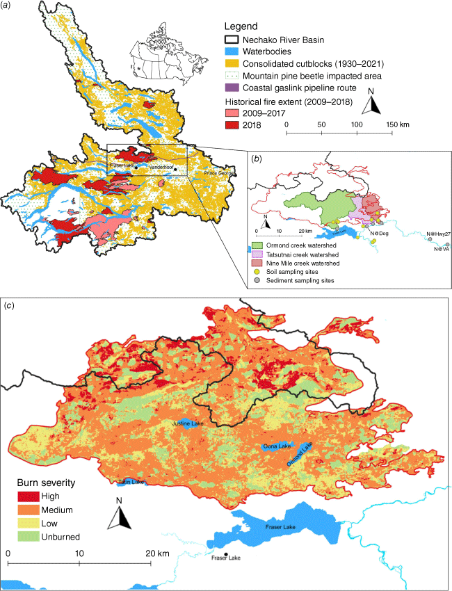
The Nechako River Basin (NRB), 54° 01ʹ 36″ N 124° 00ʹ 31″ W is located in north-central British Columbia (BC), Canada, and drains 47 200 km2 before joining the Fraser River in Prince George, BC, which eventually discharges to the Pacific Ocean in Vancouver, BC. The NRB is an ecologically important river that supports sockeye (Oncorhynchus nerka) and chinook salmon (Oncorhynchus tshawytscha), and the endangered Nechako white sturgeon (Acipenser transmontanus) (McAdam et al. 2005). Constructed in the 1950s, the Kenney Dam and Skins Lake spillway have significantly altered the flow of the Nechako River. Today, approximately 50% of the historic discharge is diverted outside of the basin to produce power for an aluminium smelter in Kitimat, BC.
Soils in the NRB are primarily brunisols beneath a thin surficial humus layer, and parent material is primarily grey basalt or sandy till (Cook and Dunn 2006). Mean annual air temperature in the basin is 3.7°C and mean annual precipitation is 601 mm. The mean annual discharge of the Nechako River at the Water Survey of Canada hydrometric station in Vanderhoof, BC, is 114.4 m3 s−1 with peak discharges between 350 and 400 m3 s−1 (1981–2017), typically occurring during the snowmelt period, between late May and late June. In the 3 weeks prior to the deployment of sediment samplers on 11 October 2018, conditions were dry, with just 14.2 mm of precipitation falling, but from the deployment of the samplers to collection of the sample in November 2018, 75.6 mm of rain and 8 cm of snow fell, potentially causing runoff of the PAH-laden ash.
Land use within the basin is dominated by forests (natural and harvested) and agriculture, with some mining and small residential communities (Fig. 1a). The Mountain Pine Beetle (MPB) outbreak began in the late 1990s and peaked in 2005 but continues today, a period that corresponds to nearly 50% of total merchantable pine trees being killed across BC (BC Ministry of Forests 2021). In response, the BC Ministry of Forests increased the annual allowable cut (AAC) to capture as much monetary value from the dead trees as possible (Bogdanski et al. 2011). For example, in the area around the NRB, the AAC was doubled, corresponding to trees being harvested within 5–15 years of the outbreak, which normally would have been harvested over decades (BC Ministry of Forests and Range 2007). This is relevant because the large number of dead trees remaining after the MPB outbreak are a source of fuel for wildfires, and the loss of forest cover increased the risk of runoff and erosion. In 2018, the NRB experienced its worst fire season in the past decade, with one of the largest being the Shovel Lake wildfire, which began 27 July 2018 and was considered contained by 5 September 2018. This mixed severity fire (Fig. 1c) burned 92 000 ha (i.e. 920 km2), nearly all of which was within the boundary of the NRB. Fire severity categories were determined by calculating the difference between the pre- and post-fire short wave and near-infrared imagery bands from LANDSAT 8. A differenced normalised burn ratio calculation on those bands was used to create a raster with continuous values, which was reclassified into the four categories as seen in Fig. 1c (BC Forest Analysis and Inventory Branch 2020).
(a) Map of landscape disturbances within the Nechako River Basin and research study area. (b) Map of the studied tributaries, soil and sediment sampling sites. (c) Fire severity map of the 2018 Shovel Lake fire, created using the differenced normalised burn ratio on pre- and post-fire short wave and near-infrared imagery bands (BC Forest Analysis and Inventory Branch 2020).
Soil sampling
Soil samples were collected from five burned (B1–B5) and five unburned (U1–U5) sites in October 2018 (Table 1), immediately following the rescinding of the evacuation order (Fig. 1b). At each burned site, samples were collected at three depths, consisting of the burned organic material that was scraped from the soil surface, the burned soil layer (0–2 cm) and the unburned subsurface soil (2–10 cm). The burned organic material was primarily composed of the burned O-horizon, with large debris such as pine needles and pine cones removed. It included white ash, material that was decomposing at the time of the fire and some mineral soil. At the unburned sites, only the upper soil layer (0–2 cm), with the organic layer removed, and subsurface soil (2–10 cm) were collected. The unburned soil sites consisted of a mix of land uses and vegetation cover (Table 1) because these are established sites with prior data and because they were areas of unburned forest within the burned watersheds that were also accessible. The burned organic layer and burned upper soil layer were collected by scraping the surface using a hand trowel, and the samples down to 10 cm were collected using a JMC Backsaver Hand Soil Sampler (Clements Associates Inc., Newton, Iowa, USA). At each of the five burned and five unburned sites, 15–20 soil sub-samples were collected and composited to capture potential soil heterogeneity, while ensuring that all sub-samples were collected within the same soil type. Soil texture at the 10 sampling sites was primarily loam but ranged from silty clay loam to loamy sand (Table 1). Soil samples were collected from the burned sites again in 2020 and 2021, but were confined to only the surface soil layer (to be referred to as topsoil throughout the manuscript) because the burned organic layer had mostly been removed and because of the low concentrations of PAHs in the subsurface soils collected in 2018.
| Site | Previous land cover | Date harvested | Burn severity | Tree species (%) | Dominant soil type (texture) |
|---|---|---|---|---|---|
| B1 | Cutblock | 2013 | Medium | PLI (70), SX (30) | Barrett – orthic grey luvisol (L) |
| B2 | Cutblock | 2013 | Medium | PLI (70), SX (30) | Barrett – orthic grey luvisol (L) and Ormond – orthic dry brunisol (SL) |
| B3 | Cutblock | 2013 | Medium | FDI (90), PLI (10) | Barrett – orthic grey luvisol (L) and Ormond – orthic dry brunisol (SL) |
| B4 | Shrubland | – | Low | AT (40), PLI (40), SX (20) | Vanderhoof – orthic grey luvisol (SiCL) |
| B5 | Cutblock | 2012 | Medium | AT (60), SX (20), PLI (10), ACT (10) | PETA – eluviated dystric brunisol (SL) |
| R1 | Cropland | – | – | – | Nechako – orthic grey luvisol (SiL) |
| R2 | Forested | – | – | AT (50), SX (20), PLI (20), ACT (10) | Nechako – orthic grey luvisol (SiL) |
| R3 | Forested/Riparian | – | – | AT (60), SX (30), PLI (10) | Berman – orthic grey luvisol (SiL) |
| R4 | Cropland | – | – | – | Vanderhoof – orthic grey luvisol (SiCL) |
| R5 | Exposed land (roadside) | – | – | – | Mapes – orthic regosol (LS) |
Tree species: PLI, lodgepole pine; SX, spruce hybrid; FDI, interior Douglas fir; AT, trembling aspen; ACT, black cottonwood. Soil texture: L, Loam; SL, sandy loam; SiCL, silty clay loam; SiL, silty loam; LS, loamy sand.
Sediment sampling
Sediment sampling was undertaken from October 2018 through September 2021, during the ice-free period (generally April to November). Samplers were located at six sites, which included three tributaries (Fig. 1b): Ormond; Nine Mile and Tatsutnai Creeks; and at three sites on the Nechako River mainstem: immediately upstream from the outlet of Dog Creek (N@Dog); beneath the bridge crossing at Highway 27 (N@Hwy27); and beneath the bridge in the town of Vanderhoof (N@VA). Ormond Creek is the largest of the three tributaries (248 km2), with steep headwaters that level out into large flood plains near its outlet into Fraser Lake. Nine Mile (66.1 km2) and Tatsutnai Creeks (68.2 km2) are smaller watersheds that are less steep and empty directly into the Nechako River. These tributaries were chosen because they were all significantly impacted by the Shovel Lake wildfire and were primarily forested or harvested and replanted prior to the fire.
In order to collect a suitable mass of sediment for PAH analysis, at each site two passive sediment samplers (Phillips et al. 2000) were attached to weights and placed on the bed of the stream or river. The samplers were emptied every 2 weeks beginning during the snowmelt period (April/May) through mid-July, after which they were only emptied monthly due to low flows in late summer and autumn. After emptying the water and sediment contained in the samplers into 19 L buckets, they were transported back to the laboratory and were left to settle for ∼48 h, after which they were dewatered by siphoning the water by hand, with caution taken to avoid siphoning any of the sediment that had been collected. The sediment remaining in the buckets was prepared for analysis in two ways depending on the analysis being undertaken, as described in the following section.
Laboratory analysis
Sediment and soil samples were wet sieved to 1 mm and a sub-sample was taken and frozen at −20°C for additional laboratory analysis. Unfrozen samples that were analysed for PAHs were shipped on ice to maintain a temperature below 4°C. All samples were analysed for PAHs by AXYS/SGS laboratories (Sidney, BC, Canada). In brief, samples were homogenised and fortified with a suite of 17 deuterium-labelled quantification standards, after which they were extracted by Soxhlet using dichloromethane. Extracts were chromatographically cleaned using a combination of silica and alumina columns, and once cleaned, the extracts were then reduced in volume and fortified with internal recovery standard. Instrumental analysis was performed by gas chromatography with mass spectrometric detection (GC/MS) using an Agilent 6890N gas chromatography/MSD system, and final concentrations were reported in ng g−1. More detailed methods can be found in the Supplementary material.
The following 16 US Environmental Protection Agency (EPA) Priority PAHs were analysed for: naphthalene (Nap); acenaphthene (Ace); acenaphthylene (Acy); anthracene (Ant); fluorene (Flu); phenanthrene (Phe); fluoranthene (Flt); pyrene (Pyr); chrysene (Chr); benz[a]anthracene (BaA); benzo[a]pyrene (BaP); benzo[b]fluoranthene (BbF); benzo[j,k]fluoranthenes (BjkF); dibenz[a,h]anthracene (DaA); indeno[1,2,3-cd]pyrene (Ind); benzo[ghi]perylene (BgP).
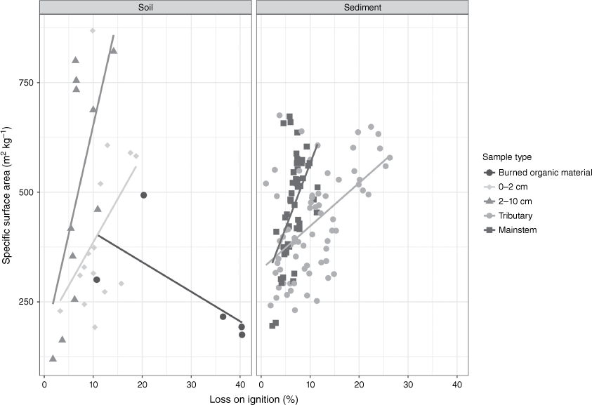
Analysis of the frozen sub-samples was undertaken by first thawing samples, then drying them for 48 h at 40°C. They were then ground and sieved to 1 mm, and analysed for organic matter content by the loss on ignition method (Heiri et al. 2001). Particle size and specific surface area (SSA) analysis was undertaken on the 1 mm samples after treatment with hydrogen peroxide (with the exception of the burned organic material) to remove organic material, and after chemical (sodium hexametaphosphate) and physical (ultrasonic) dispersion on a Malvern Mastersizer 3000 (Malvern Panalytical, Malvern, UK).
Statistical analysis
All statistical analysis was undertaken using R software (v 4.1.0; R Core Team 2021) in R Studio (v. 1.4.1717), and plots were created using the ggplot2 package (Wickham 2016). The Shapiro–Wilk test was undertaken to check for normality on soil and sediment samples, and all data sets were found to be non-normal. Therefore, the Kruskal–Wallis and Friedman Rank Sum tests, non-parametric alternatives to a one-way ANOVA and ANOVA repeated measures tests respectively, were used.
PAH apportionment using molecular ratios and PAH profiles with chi-square tests
Molecular ratios are a common tool used to determine sources of PAHs, primarily by differentiating between pyrogenic and petrogenic sources, though some ratios can be used to further elucidate specific sources (i.e. coal burning or diesel fuel emissions vs wildfires) (Kieta et al. 2023). For this study, the two molecular ratios used were Flt/(Flt + Pyr) and Phe/(Phe + Ant), from the 202 and 178 molecular weight series, respectively.
A secondary method used for source apportionment in this study was to first calculate PAH profiles for each sediment sample, and for the burned organic material and burned topsoil. This was completed using proportional concentrations of 12 PAHs (Ant, BaA, BaP, BbF, BgP, BjkF, Chr, Flt, Ind, Phe, Pyr and benzo[e]pyrene (BeP)), meaning the individual compound was calculated as a fraction of the sum of the aforementioned 12 compounds for each sediment sample. These proportional concentrations were compared with proportional concentrations calculated in the same way from the burned organic material (BORM) and burned topsoil (BTOP) samples collected for this study in 2018, and from proportional concentration values from the literature. The values from the literature came from Van Metre and Mahler (2014), with the exception of weathered creosote-treated railway ties (CRE2) (Covino et al. 2016) and pine wood soot particles (PIN2) (Crane 2014). To evaluate the comparison between proportional values from the sediment samples and those from the literature and from the source (i.e. soil) samples collected in this study, the chi-square test statistic was used. This was calculated as the squared difference in proportional concentrations of the sediment sample and source for each individual compound divided by the mean of these two values and summed for the 12 PAHs, following the methods of Van Metre and Mahler (2010).
Results
Particle size composition and organic matter content of soils and sediments
The highest measures for specific surface area (SSA, based on mass) were found in the soil samples from an unburned topsoil site (868.8 m2 kg−1), though the subsoil samples from the unburned sites were consistently elevated with the exception of one sample, which was collected beside a road. All of the burned organic material samples had a SSA below 500 m2 kg−1, and of the five samples, four had the highest recorded values for LOI, all above 20% and with two samples above 40%. In the sediment samples, there was a significant difference (P < 0.005) between mainstem and tributary sites, with higher LOI found in the tributary samples, which was primarily driven by Tatsutnai Creek. None of the mainstem sites recorded values of LOI greater than 12%, and 35% of tributary samples were greater than 12%. The distribution of SSA for sediment samples did not produce any clear patterns because there were no significant differences between the tributary and mainstem samples (P > 0.05).
As shown in Fig. 2, the results of Spearman’s correlation tests found that in the soil samples, there was a significant positive correlation between LOI and SSA in the subsurface soils across all sites (rho = 0.788, P = 0.004). However, the positive correlation in topsoil and negative correlation in the ash were not significant (P > 0.05). There was a positive correlation between LOI and SSA in both the mainstem and tributary sites, though neither were significant (P > 0.05). There were also no significant correlations (P > 0.05) found between total PAHs and SSA or LOI for any of the grouped sites (i.e. tributaries, mainstem, etc.).
Concentrations of PAHs in burned organic material
Samples of burned organic material and burned topsoil (0–2 cm) collected in October 2018 contained the highest concentrations of ∑PAHs throughout the duration of the study (Fig. 3). Of those samples, the burned organic material had the highest average ∑PAH concentrations, and the samples collected at B1 (6504.6 ng g−1), B2 (8260.8 ng g−1) and B3 (4576.0 ng g−1) had more than double the ∑PAH concentrations than at sites B4 (1170.5 ng g−1) and B5 (1990.8 ng g−1). Site B4 exhibited the lowest concentrations of PAHs for each individual analyte.
Concentrations of the 16 US Environmental Protection Agency priority polycyclic aromatic hydrocarbons (PAHs) from terrestrial samples collected in October 2018. For each panel, samples from the fire-affected sample sites for burned organic material (OM) are shown from left (B1) to right (B5), and for both burned and unburned sites for 0–2 and 2–10 cm from left (B1) to right (U5). From top left to bottom right, the first six PAHs are low molecular weight (Naphthalene to Phenanthrene), and remaining are high molecular weight (Fluoranthene to Benzo[ghi]perylene). Note the different y-axis scales depending on the PAH.
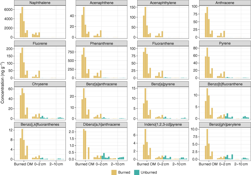
The burned organic layer was dominated by LMW PAHs, which made up >90% of ƩPAHs. More specifically, Nap was the predominant analyte, with concentrations ranging from 940 ng g−1 at B4 to 6540 ng g−1 at site B2. Except for site B4 (130 ng g−1), Phe was the second-most prevalent PAH, with concentrations ranging from 256 to 874 ng g−1 (Fig. 3). Two- and three-ring PAHs constituted the majority of PAHs at all sites. There was a significant difference between the burned organic material and both the topsoil (P = 0.008) and the subsurface soil (P = 0.002).
Concentrations of PAHs in topsoil
Topsoil samples from 2018 followed similar patterns to the burned organic layer across sites with respect to the dominant species of PAHs and the ring size distribution (Fig. 3), but ƩPAH concentrations were significantly lower (P < 0.0455) in topsoil samples. The maximum ƩPAH concentration was recorded at site B5 (1456.2 ng g−1) and the minimum was recorded at B4 (525.4 ng g−1). The dominant PAHs in all topsoil samples were LMW PAHs and more specifically, Nap, which made up the majority of total PAHs in 2018.
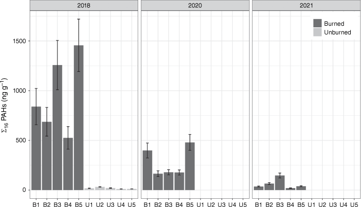
Concentrations of ƩPAHs in topsoil decreased significantly at all burned sites from 2018 to 2020 (P = 0.025) and decreased again in 2021 (Fig. 4), though not significantly (P = 0.254). Many of the HMW PAHs were higher at unburned sites from 2018 than the burned sites from 2021 (Fig. 4). However, for the LMW PAHs, samples from the burned sites B1–B3, and B3 in particular, still exhibited significantly elevated concentrations in 2021 compared with unburned sites sampled in 2018 (P = 0.03). As concentrations decreased over time, LMW PAHs, and more specifically Nap, were the most dominant PAHs.
Concentrations of PAHs in subsurface soil
PAH concentrations in subsurface soil samples were significantly lower (P = 0.002) than topsoil samples (Fig. 3). Additionally, samples collected from the subsurface soil layer (2–10 cm) showed no significant differences (P = 0.44) between burned and unburned sites for individual PAHs nor for ƩPAHs.
Concentrations of PAHs in tributary sediments – Ormond, Tatsutnai and Nine Mile Creeks
Samples collected in November 2018 had the highest concentrations of ∑PAHs recorded throughout the study for each of the tributary sites (Fig. 5), with Ormond Creek (91.9 ng g−1) and Tatsutnai (76.8 ng g−1), the two more severely burned tributaries, higher than Nine Mile Creek (26.3 ng g−1). At both Ormond and Tatsutnai Creeks, the sample collected in November 2018 also was significantly (P < 0.05) higher in each individual PAH than at these sites throughout the rest of the study period, with the exception of Ind, BgP and BbF.
Total polycyclic aromatic hydrocarbons (PAHs) by ring size in sediment samples collected from 2018 to 2021. Note the difference in the y-axis scale in the tributaries (a) vs the mainstem (b) sites.
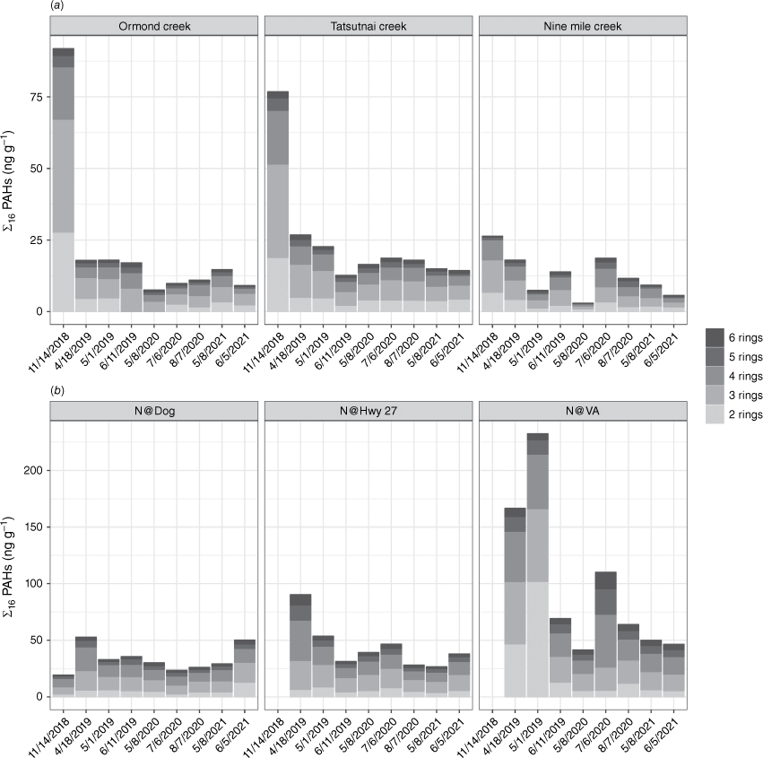
There were no significant differences in ƩPAHs (Table 2) when comparing the three tributary sites through the duration of the study (P > 0.05). Additionally, LMW PAHs (2–3 rings) were more abundant than HMW PAHs (4–6 rings) at the tributary sites, and 3-ring PAHs were the most abundant group (Fig. 5), which was similar to trends in the Nechako mainstem, as described below.
| Sampling date (d/m/y) | 14/11/18 | 18/4/19 | 1/5/19 | 11/6/19 | 8/5/20 | 6/7/20 | 7/8/20 | 8/5/21 | 5/6/21 |
|---|---|---|---|---|---|---|---|---|---|
| Days post-fire | 66.00 | 221.0 | 234.0 | 275.000 | 607.0 | 666.0 | 698.0 | 972.0 | 1000.0 |
| Ormond Creek | 91.90 (9.5) | 17.9 (1.7) | 18.0 (1.7) | 17.060 (1.7) | 7.5 (0.9) | 9.8 (0.9) | 11.0 (1.0) | 14.7 (1.3) | 9.1 (0.8) |
| Tatsutnai Creek | 76.80 (7.4) | 26.8 (2.3) | 22.7 (2.1) | 12.700 (1.1) | 16.5 (1.5) | 18.7 (1.7) | 18.0 (1.8) | 15.0 (1.3) | 14.3 (1.6) |
| Nine Mile Creek | 26.30 (2.8) | 18.0 (1.6) | 7.4 (0.7) | 13.860 (1.3) | 3.0 (0.4) | 18.7 (1.3) | 11.6 (1.0) | 9.3 (0.7) | 5.6 (0.5) |
| N@Dog | 19.26 (1.4) | 52.6 (3.8) | 32.8 (2.6) | 35.625 (2.6) | 30.2 (2.3) | 23.5 (1.6) | 26.1 (2.2) | 29.1 (2.1) | 50.2 (4.3) |
| N@Hwy27 | – | 90.3 (5.6) | 53.6 (4.3) | 31.300 (2.7) | 39.2 (3.1) | 46.6 (3.8) | 28.0 (2.5) | 26.7 (2.1) | 37.8 (3.0) |
| N@VA | – | 166.5 (13.4) | 232.3 (25.6) | 69.100 (4.9) | 41.5 (3.4) | 110.0 (5.6) | 63.9 (4.6) | 50.0 (3.4) | 46.5 (3.2) |
Note: s.d. in parentheses
Concentrations of PAHs in Nechako River mainstem sediments
The three highest concentrations of ∑PAHs were recorded at N@VA, with concentrations reaching 232 and 166 ng g−1 in spring 2019, and 110 ng g−1 after a large rainfall event in July 2020 (Fig. 5). Concentrations of ∑PAHs at all of the mainstem sites were higher than at the tributaries, though only significantly higher when comparing each mainstem site with Nine Mile Creek, and when comparing N@VA with Ormond and Tatsutnai Creeks (P < 0.05). There was a mostly equal split between LMW and HMW PAHs at N@Dog and N@Hwy27 throughout the study, though at N@VA during the 2019 spring snowmelt, LMW PAHs were prominent. Unlike the soil samples where 2-ringed PAHs were prolific, for sediment samples, 3-ringed and 4-ringed PAHs were the most abundant (Fig. 5).
There was no discernable temporal trend across the mainstem sites but at nearly all sites and across all analytes, there were elevated PAH concentrations in April and May 2019, which coincided with runoff during the first spring snowmelt post-wildfire. Concentrations of ƩPAHs were the highest at N@VA for nearly all sampling dates, with the exception being the last sample collected, in June 2021 (Table 2). Concentrations of ƩPAHs at N@VA were significantly higher than those at N@Dog (P = 0.037), but not at N@Hwy27 (P = 0.310) when comparing across all dates. There was a spike in the proportion of HMW PAHs at this site in the sample collected in July 2020 following a large rain event.
Apportionment of PAH sources using molecular ratios
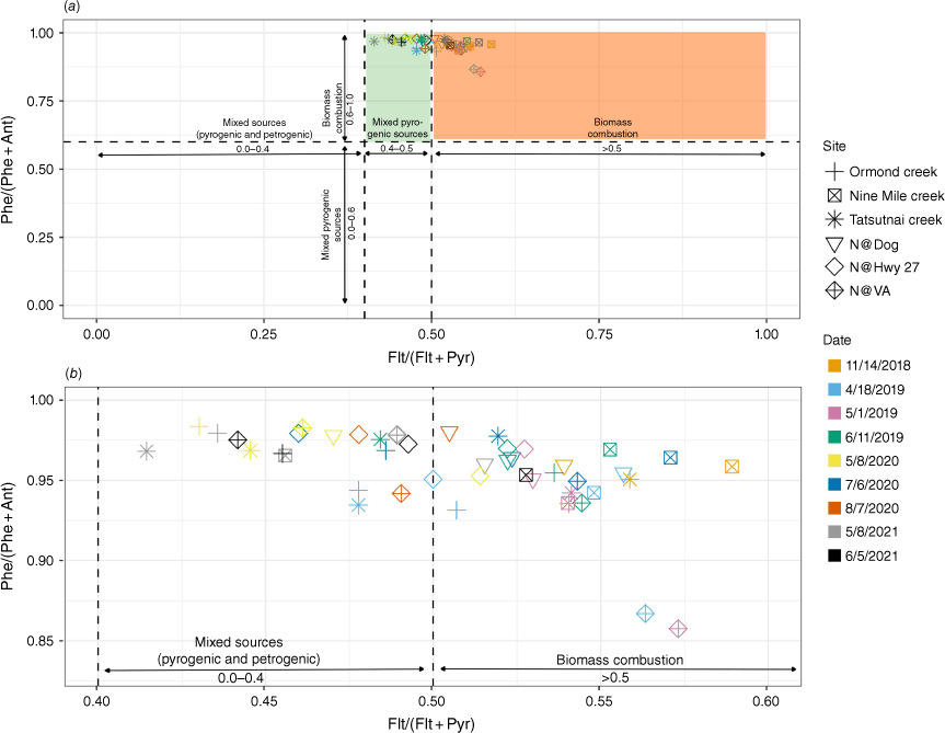
Although the relative remoteness of the tributary sites as well as N@Dog provides some qualitative evidence that the primary source of PAHs was the wildfire, the other two sites (N@Hwy27 and N@VA) are both likely to have been influenced by other sources because of their proximity to roadways. As described above, samplers at these sites were located under bridges that carry industrial and recreational traffic, and N@VA is in the heart of the town of Vanderhoof (pop. 4300), which has multiple lumber mills and industrial sites, and services a greater population of∼10 000 people (Statistics Canada 2022). Molecular ratio values >0.5 for Flt/(Flt + Pyr) denote wood and grass combustion, whereas ratios between 0.4 and 0.5 denote fuel combustion (Yunker et al. 2002). In this study, 25 samples had ratios >0.5 and 18 samples had ratios between 0.4 and 0.5 (Fig. 6a). No samples fell below 0.4, which denotes sources of petrogenic origin. However, using the Phe/(Phe + Ant) ratio, all of the samples fell within the range (0.6–1.0) for biomass combustion (Vicente et al. 2012), though samples collected at N@VA on 18 April 2019 and 1 May 2019 had lower ratios, falling closer to the range of combustion of fossil fuels (<0.6) (Fig. 6b).
Biplot of molecular ratio values using Phenanthrene/(Phenanthrene + Anthracene) and Fluoranthene/(Fluoranthene + Pyrene) to determine polycyclic aromatic hydrocarbon sources. (a) Samples falling within the orange rectangle are derived from biomass combustion (i.e. wildfire) sources, and those in the green rectangle are derived from a mixture of fossil fuel combustion and wildfire sources; (b) shows the same data but it focuses on the plotted samples.
Apportionment of PAH sources using PAH profiles and chi-square analysis
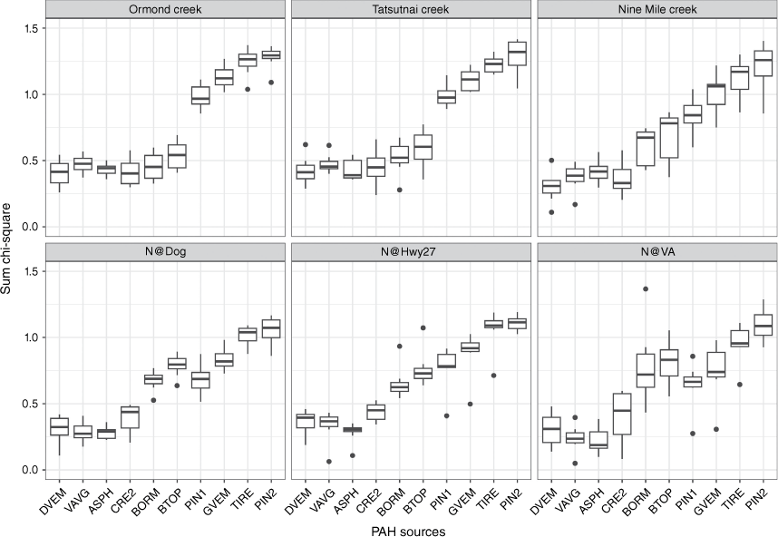
In a chi-square analysis, values closest to zero denote the greatest similarity between samples and source. In this study, PAH profiles of the sediment sites show that diesel vehicle particulate emissions, vehicle and traffic averaged emissions, asphalt and weathered creosote-treated railway ties had the lowest chi-square values across all sites (Fig. 7). However, in Ormond and Tatsutnai Creeks, BTOP and BORM, which were the soil source samples collected in this study, were similarly close to zero as the fossil fuel derived sources. This trend was not the same at Nine Mile Creek or at the mainstem sites. In total, these results show that based on sources from the literature and from samples collected for this study, at the tributary sites, a mix of burned soils, diesel emissions, average vehicle traffic emissions, asphalt and creosote-treatedrailway ties were of similar influence. This is in contrast to the mainstem sites, which were less influenced by burned soils. However, as with the molecular ratios, further lines of evidence regarding the sources of the PAHs were considered, including historical data from the region (Brewer et al. 1998; Owens et al. 2019), and are described below.
Chi-square values for sediment samples from tributaries and mainstem Nechako sites. A value closer to zero denotes the sediment sample is close to the source. Abbreviations: diesel vehicle particulate emissions (DVEM); vehicle/traffic average (VAVG); asphalt (ASH2); weathered creosote-treated railway ties (CRE2); burned organic material (BORM); burned topsoil (BTOP); pine wood soot (PIN1); gasoline vehicle particulate emissions (GVEM); tire particles (TIRE); pine wood soot particles #2 (PIN2).
Discussion
This study was undertaken in a relatively remote part of north-central BC, which stands in contrast to much of the literature on PAH contamination in sediment and soils that is based on highly urbanised and industrialised landscapes. As such, the initial impetus for this study and primary objective was to determine concentrations of PAHs with a specific focus on the role of wildfire. Although the values for individual PAHs immediately following the fire were elevated, they were still significantly lower than those in other wildfire studies (Table 3) and studies from industrial and urbanised locations across the globe generally, and across Canada specifically (see Marvin et al. 2021).
| Reference | Sample medium | Location | Concentration (ng g−1) | Months post-fire |
|---|---|---|---|---|
| Olivella et al. (2006) | Ash | Spain | 1.3–19.0 | |
| Olivella et al. (2006) | Sediment | Spain | 3.0 | |
| Vila-Escalé et al. (2007) | Sediment | Spain | 14.5 | 45 days post-fire |
| Vila-Escalé et al. (2007) | Sediment | Spain | 15.4 | 78 days post-fire |
| Vila-Escalé et al. (2007) | Sediment | Spain | 18.5 | 95 days post-fire |
| Vila-Escalé et al. (2007) | Sediment | Spain | 17.7 | 107 days post-fire |
| Vila-Escalé et al. (2007) | Sediment | Spain | 1.7 | 662 days post-fire |
| Kim et al. (2011) | Soil | South Korea | 942.0–1570.0 | 1 month post-fire (severe) |
| Kim et al. (2011) | Soil | South Korea | 153.0–304.0 | 5 months post-fire (severe) |
| Kim et al. (2011) | Soil | South Korea | 205.0–481.0 | 9 months post-fire (severe) |
| Kim et al. (2011) | Soil | South Korea | 213.0–638.0 | 1 month post-fire (small-scale) |
| Kim et al. (2011) | Ash | South Korea | 631.0–739.0 | 1 month post-fire (small-scale) |
| Vergnoux et al. (2011) | Soil | France | 157.0 | Numerous very recent fires |
| Vergnoux et al. (2011) | Soil | France | 77.0 | Numerous recent fires |
| Vergnoux et al. (2011) | Soil | France | 89.0 | Few recent fires |
| Choi (2014) | Soil | South Korea | 26.6–274.0 | 1 month post-fire |
| Choi (2014) | Soil | South Korea | 72.1–124.0 | 3 months post-fire |
| Choi (2014) | Soil | South Korea | 37.5–102.0 | 5 months post-fire |
| Choi (2014) | Soil | South Korea | 17.9–59.6 | 7 months post-fire |
| Simon et al. (2016) | Soil | South Korea | 40.5–294.0 | |
| Simon et al. (2016) | Ash | South Korea | 1169.0–11 007.0 | |
| Campo et al. (2017) | Soil | Spain | <200.0–1255.0 | |
| Campo et al. (2017) | Sediment | Spain | 3154.0 |
Organic matter content
Baran et al. (2021) focused on a range of organic matter fractions and found that there was a positive correlation between total organic carbon (TOC) and ƩPAHs in bottom sediments in the Rożnów reservoir in Poland, and for dissolved organic carbon and fulvic acid carbon there was a significant relationship between ƩPAHs and 2–3-ring compounds. In the context of the work presented here, this finding is of particular note because of the dominance of 2–3 ring PAHs in both soils and sediments. However, the correlation between TOC and PAH concentrations is not always agreed upon in the literature, with some studies finding TOC to be a determinate of PAH concentrations (Jiang et al. 2009; Nascimento et al. 2017) and others finding no correlations (Nudi et al. 2007; Mostafa et al. 2009). Determining other factors that may influence this relationship will better predict the potential impacts that PAHs bound to organic material may have on aquatic organisms (Honda and Suzuki 2020).
PAH concentrations in soils and sediments
Samples of burned organic material contained the highest concentrations of PAHs and were predominantly LMW PAHs. These results are similar to those of Kim et al. (2011), who found that 2–4 ring PAHs were the most abundant after wildfire in South Korea, and that Nap and Phe were significantly elevated compared with the other individual PAHs. Additionally, Campos et al. (2019) found that both ash and soil samples collected after a eucalyptus forest fire in Portugal were dominated by 3–4 ring PAHs, which was a similar result to this study. These findings are particularly important when considering the potential impacts on waterways, because LMW PAHs are found in higher concentrations than HMW PAHs in the dissolved form (Rabodonirina et al. 2015).
One of the objectives of this research was to determine temporal changes in PAH concentrations in soils and sediments to better understand the potential long-term risk after wildfire. Particularly with respect to soils, this is also an area where there are significant differences across studies. In the present study, concentrations had not returned to background levels after 3 years, whereas Kim et al. (2011) found that concentrations in soils returned to background levels within just 5 months, likely due to the loss of burned soils and ash from wind erosion, volatilisation and most importantly, runoff. Mean annual precipitation was not reported in that study, but the authors note that sampling occurred in the 1–5 month period after their rainy season, which produces significant precipitation and likely created enough runoff and erosion to significantly decrease PAH concentrations. In a comprehensive study focused on the temporal changes of PAH concentrations post-wildfire, Vergnoux et al. (2011) found that although Flt and Pyr returned to baseline levels within 3 years, Nap remained at elevated concentrations for more than 16 years, a surprising result because it is a 2-ring PAH that is susceptible to rapid volatilisation and leaching. That study was undertaken in a mediterranean ecosystem, with mean annual precipitation of 800–1200 mm – higher than the present study (∼601 mm). However, although the results from Vergnoux et al. (2011) were unexpected with respect to the elevated Nap concentrations, in the present study, concentrations of Nap were still significantly higher than in unburned soils collected in 2018, though this study area has only been monitored for 3 years post-fire. Also, with the exception of Nap, concentrations of the other individual PAHs in this study had decreased significantly and were nearly back to baseline, as has been reported in numerous other wildfire studies (Kim et al. 2011; Simon et al. 2016; Campos et al. 2019).
The high concentrations of ƩPAHs in sediments in the tributaries immediately following the wildfire in November 2018 are evidence that the late autumn rain and snow events generated runoff, which likely transported the burned organic material and some topsoil to the aquatic environment. This is consistent with results from numerous studies that concluded reduced PAH concentrations in soils in the short and long term were partially due to loss by runoff (Kim et al. 2011; Simon et al. 2016). Additionally, Campos et al. (2012) explicitly measured runoff and found elevated concentrations of PAHs that decreased over time, another line of evidence showing that enriched ash and soils are a driver of PAH concentrations in sediments. In this study, the Nechako mainstem showed high concentrations in spring 2019, which points to the spring snowmelt being another avenue for delivery of PAHs to the aquatic environment. The other studies on PAHs in sediment post-wildfire have not been undertaken in cold climates with significant snowfall, but the findings of this study align with research of other contaminants that show elevated concentrations during the spring snowmelt period (Westerlund et al. 2003; Engelhard et al. 2007; Blecken et al. 2012). In addition to material mobilised during the snowmelt, sediments that were mobilised in the previous autumn and stored in the riverbed over winter could have been resuspended during the high flows in the spring.
Another of the objectives of this research was to determine the spatial scale of PAH contamination, and the results show that the spatial extent in this study was much larger than the sub-watersheds that burned. Previous wildfire-derived PAH studies (e.g. Olivella et al. 2006; Vila-Escalé et al. 2007; Hunsinger et al. 2008) that monitored sediment concentrations did not sample at multiple locations moving downstream from the wildfire source, as was undertaken in this study, so explicit comparisons on a spatial scale are not feasible. However, Olivella et al. (2006) did monitor water at multiple sites and found that PAH concentrations were particularly high immediately post-wildfire, likely due to atmospheric deposition, but decreased in response to rainfall, likely due to a dilution effect. Hunsinger et al. (2008) collected multiple sediment samples from the Santa Barbara channel, California, and found that there was a clear signal of wildfire from watersheds draining into the channel, though there were no explicit spatial patterns that were identified. Finally, specific to the samples collected on the Nechako mainstem, an interesting observation was the difference between PAH concentrations at N@Hwy27 and N@VA. There is no drainage area impacted by wildfire between sites N@Hwy27 and N@VA; therefore, the elevated PAH signal at the latter site is unlikely to have been derived solely from wildfire. Instead, it potentially reflects the incorporation of PAHs from additional sources.
There has been a significant amount of research on PAH concentrations in sediments of highly industrialised and urbanised watersheds, but in areas where PAHs would be primarily wildfire-derived, there has been far less. However, those few studies are a useful comparison for the work described in this paper. Olivella et al. (2006) and Vila-Escalé et al. (2007) both sampled sediments in the Catalonia region of Spain after severe wildfire, and found maximum concentrations of 2.7 and 19.3 ng g−1 respectively. The aforementioned research from Hunsinger et al. (2008) in the Santa Barbara channel, California, is useful because this is an area where there are significant petroleum deposits. Using radionuclides and stable isotopes, they were able to discern that wildfire was the primary PAH contributor, with concentrations ranging from 202 to 1232 ng g−1. The results presented here fall in between these studies, with maximum ΣPAH concentrations in sediment samples of 91.9 and 232 ng g−1 in the tributaries and mainstem, respectively. The comparison of the results from this study with those of other wildfire-derived PAH studies on a temporal scale is more difficult for sediments than for soils, because of the three studies noted above, the only one that monitored PAHs in sediments beyond 6-months post-wildfire was Vila-Escalé et al. (2007). They found that PAH concentrations peaked 3 months post-wildfire. However, soon after the peak, concentrations began to fall and had reached near background levels after 662 days. Those results are similar to the present study; concentrations had fallen significantly by the end of the study but were still detectable, so not as low as the concentrations found in sediment samples collected in the NRB in 2015, prior to the 2018 wildfire (Owens et al. 2019).
Comparison with Canadian soil and sediment guidelines
There are multiple guidelines for individual PAHs in soils in Canada, but for this study we have compared soil values with those outlined by the Canadian Council of Minsters of the Environment (CCME) for environmental health protection against non-carcinogenic effects (CCME 1999). For all PAHs with the exception of Ant and Flt, this number is the interim soil quality criteria (SQC) (CCME 1991). For Ant (2500 ng g−1) and Flt (15 400 ng g−1), the number referenced is the soil quality guideline for environmental health (SQGE), which is based on the lowest concentration among several soil quality guidelines (e.g. soil contact, soil and food ingestion or freshwater life).
Burned organic material samples were above the SQC at all sites for Nap (600 ng g−1) and Phe (100 ng g−1), but not for any other individual PAH. Concentrations of Nap in topsoil samples at B1, B3 and B5 from 2018 exceeded the 600 ng g−1 threshold in topsoil samples from 2018, though B2 was also near exceedance (581 ng g−1). Not one of the samples collected in 2020 or 2021 is above the SQC for Nap. The other individual PAH that had concentrations exceeding the SQC was Phe, where concentrations from 2018 samples at B3 (151 ng g−1) and B4 (219 ng g−1) were above the 100 ng g−1 threshold. At site B4, Phe concentrations were near the threshold in 2020 (98.6 ng g−1) and remained below it in 2021. There were no significant differences between topsoil samples from unburned and burned sites for many of the HMW PAHs, particularly BgP, BbF, Ind and DaA.
There are fewer guidelines for PAHs in sediments, but the CCME has created interim sediment quality guidelines (ISQG) and probable effect limits (PEL) for 13 PAHs. In this study, we compared values from sediment samples with the ISQG for each individual PAHs. The ISQG refer to maximum concentrations in bottom or benthic sediments because of their potential impacts on bottom-dwelling organisms. The highest concentrations for individual PAHs at the tributary sites were Phe and Nap, though all samples were below the ISQG (41.9 and 34.6 ng g−1, respectively). Additionally, MacDonald et al. (2000) developed consensus-based threshold effect concentrations (TECs) for ∑PAHs (1610 ng g−1), but there were no samples from the tributaries where concentrations were above this TEC (Table 2).
The only instances of concentrations recorded above the ISQG in the Nechako River mainstem were collected at N@VA. In April 2019 and May 2019, concentrations of Nap reached 46.8 and 102 ng g−1 respectively, above the CCME (1999) ISQG guideline (34.6 ng g−1). In May 2019, Phe concentrations reached 43.2 ng g−1, above the ISQG (41.9 ng g−1). For all other individual PAHs, concentrations were below the ISQGs and concentrations for ƩPAHs were below the TECs.
PAH apportionment
The final objective of this research was to determine the primary sources of PAHs in the watershed, with a focus on the role of the 2018 Shovel Lake wildfire. Molecular ratios for PAH apportionment have been widely used as a coarse method for source apportionment but their reliability has been questioned for a range of reasons (Yunker et al. 2002; Wagener et al. 2010; Katsoyiannis et al. 2011; Net et al. 2015; Kieta et al. 2023). Therefore, as introduced by Baldwin et al. (2020), the use of multiple lines of evidence, such as the chi-square test and traditional molecular ratios used in this study, are likely to give a more complete understanding.
The molecular ratios and chi-square test results show mixed sources in the NRB, and that vehicle and road emissions are important sources of PAHs. However, because there are prior data available for the NRB, these methods should be considered within a wider context. Brewer et al. (1998) collected samples from four sites on the Nechako mainstem from 1994 to 1996, and concentrations were significantly lower than those found at all sites and all dates throughout the present study.
Additionally, in 2015 and 2016, Owens et al. (2019) collected channel bed material samples from multiple tributaries and at sites on the Nechako mainstem, and all of the concentrations were below PAH detection limits. It is important to acknowledge the impact of the timing of sampling because neither study noted above was undertaken immediately following wildfire on the scale of the 2018 Shovel Lake fire and thus both reflect PAH concentrations during non-wildfire conditions. More broadly, because fine sediment that is stored on stream and riverbeds can be remobilised and transported downstream during high-flow events, the timing of sampling is crucial – these high-flow events can act to ‘reset’ the system. For example, in this study, PAH concentrations were elevated following a large precipitation event in July 2019, but had been decreasing prior to that sample and continued to decrease by the next sample collection date (August 2019). Therefore, based on the prior data collected in the NRB and the timing of the sampling with respect to the Shovel Lake wildfire, it is most likely that wildfires were a major, if not the primary, source of PAHs in the tributaries, but a lesser contributor in the mainstem sites, particularly N@Hwy27 and N@VA where other sources dominate. These results for the Nechako mainstem sites were not necessarily predicted because the prior work in the NRB (Brewer et al. 1998; Owens et al. 2019) and its relative remoteness advanced the idea that, from a contaminant perspective, this watershed would have few potential inputs of PAHs. It is thus an important finding that though PAH concentrations were low, even light industry and urbanisation will have a measurable impact.
Conclusions
The objectives of this study were to determine the spatial and temporal extent of PAH contamination post-wildfire in a relatively remote region of British Columbia, Canada, as well as to elucidate the sources of PAHs in this watershed. The results show that many individual PAHs can remain in the terrestrial and aquatic environments for several years post-wildfire and will continue to move downstream over time. However, much of the prior research on PAH contamination following wildfire has been on soils or on a small number of sediment grab samples, which limits spatial implications and comparisons for this work. The findings described here, namely that wildfire was likely not the primary source of PAHs in the Nechako River mainstem – and that concentrations in the tributaries that were heavily impacted by the Shovel Lake fire were not as high as those in the mainstem – were unexpected, but should prove to be useful in future studies in wildfire-impacted watersheds.
This research has identified that in addition to areas with significant industrial development and urban centres, severe wildfire can also produce high concentrations of PAHs that are deposited into soils and transported to the aquatic environment. The focus here was on PAH concentrations, but because wildfire creates significant changes to the landscape, there are other cumulative impacts post-wildfire, including altered quantity and timing of flow and changes in suspended sediment, nutrients, metals and other pollutants. These changes, taken in combination with even relatively low increases in PAH concentrations, could cause adverse impacts on aquatic organisms, though this is an area that needs significantly more research.
In the future, many regions of the world (including North America) will experience an increasing number of large-scale wildfires of greater severity. The environmental impacts associated with these fires is expected to be one of the greatest challenges related to the climate crisis. One aspect of these wildfire impacts will be the contamination of soils by PAHs and the transport of those PAHs to adjacent streams, rivers, wetlands and lakes. This could pose a risk both to the terrestrial and aquatic organisms that reside in these environments; consequently, further research on the long-term persistence of PAHs derived from wildfires is urgently needed.
References
Abdel-Shafy HI, Mansour MSM (2016) A review on polycyclic aromatic hydrocarbons: source, environmental impact, effect on human health and remediation. Egyptian Journal of Petroleum 25, 107-123.
| Crossref | Google Scholar |
Achten C, Andersson JT (2015) Overview of Polycyclic Aromatic Compounds (PAC). Polycyclic Aromatic Compounds 35, 177-186.
| Crossref | Google Scholar |
Ainerua MO, Tinwell J, Kompella SN, Sørhus E, White KN, van Dongen BE, Shiels HA (2020) Understanding the cardiac toxicity of the anthropogenic pollutant phenanthrene on the freshwater indicator species, the brown trout (Salmo trutta): from whole heart to cardiomyocytes. Chemosphere 239, 124608.
| Crossref | Google Scholar |
Baek SO, Field RA, Goldstone ME, Kirk PW, Lester JN, Perry R (1991) A review of atmospheric polycyclic aromatic hydrocarbons: sources, fate and behavior. Water, Air, and Soil Pollution 60, 279-300.
| Crossref | Google Scholar |
Baldwin AK, Corsi SR, Oliver SK, Lenaker PL, Nott MA, Mills MA, Norris GA, Paatero P (2020) Primary sources of polycyclic aromatic hydrocarbons to streambed sediment in Great Lakes Tributaries using multiple lines of evidence. Environmental Toxicology and Chemistry 39, 1392-1408.
| Crossref | Google Scholar |
Baran A, Klimkowicz-Pawlas A, Ukalska-Jaruga A, Mierzwa-Hersztek M, Gondek K, Szara-Bąk M, Tarnawski M, Spałek I (2021) Distribution of polycyclic aromatic hydrocarbons (PAHs) in the bottom sediments of a dam reservoir, their interaction with organic matter and risk to benthic fauna. Journal of Soils and Sediments 21, 2418-2431.
| Crossref | Google Scholar |
BC Forest Analysis and Inventory Branch (2020) ‘Fire Burn Severity - Historical.’ (Ministry of Forests, Lands, Natural Resource Operations and Rural Development: Victoria, BC, Canada) Available at https://catalogue.data.gov.bc.ca/dataset/fire-burn-severity-historical
BC Ministry of Forests (2021) ‘The 1999-2015 mountain pine beetle outbreak - Province of British Columbia.’ (Province of British Columbia) Available at https://www2.gov.bc.ca/gov/content/industry/forestry/managing-our-forest-resources/forest-health/forest-pests/bark-beetles/mountain-pine-beetle/responding-to-the-1999-2015-outbreak
BC Ministry of Forests and Range (2007) ‘Timber Supply and the Mountain Pine Beetle Infestation in British Columbia – 2007 Update.’ (B.C. Ministry of Forests and Range: Victoria, BC, Canada) Available at https://www.for.gov.bc.ca/hfd/library/mpb/bib106767.pdf
Bilodeau JC, Gutierrez Villagomez JM, Kimpe LE, Thomas PJ, Pauli BD, Trudeau VL, Blais JM (2019) Toxicokinetics and bioaccumulation of polycyclic aromatic compounds in wood frog tadpoles (Lithobates sylvaticus) exposed to Athabasca oil sands sediment. Aquatic Toxicology 207, 217-225.
| Crossref | Google Scholar |
Bilotta GS, Brazier RE (2008) Understanding the influence of suspended solids on water quality and aquatic biota. Water Research 42, 2849-2861.
| Crossref | Google Scholar |
Birdsall K, Kukor JJ, Cheney MA (2001) Uptake of polycyclic aromatic hydrocarbon compounds by the gills of the bivalve mollusk Elliptio complanata. Environmental Toxicology and Chemistry 20, 309-316.
| Crossref | Google Scholar |
Blecken G-T, Rentz R, Malmgren C, Öhlander B, Viklander M (2012) Stormwater impact on urban waterways in a cold climate: variations in sediment metal concentrations due to untreated snowmelt discharge. Journal of Soils and Sediments 12, 758-773.
| Crossref | Google Scholar |
Bogdanski BEC, Sun L, Peter B, Stennes B (2011) ‘Markets for forest products following a large disturbance: opportunities and challenges from the mountain pine beetle outbreak in western Canada.’ (Pacific Forestry Centre: Victoria, BC, Canada) Available at https://cfs.nrcan.gc.ca/pubwarehouse/pdfs/32226.pdf
Brewer R, Sekela M, Sylvestre S, Tuominen T, Moyle G (1998) ‘Contaminants in Bed Sediments from 15 Reaches of the Fraser River Basin.’ (Environment Canada, Environmental Conservation Branch, Aquatic and Atmospheric Sciences Division, Pacific and Yukon Division, DOE FRAP 1997-37: Vancouver, BC, Canada)
Campos I, Abrantes N (2021) Forest fires as drivers of contamination of polycyclic aromatic hydrocarbons to the terrestrial and aquatic ecosystems. Current Opinion in Environmental Science & Health 24, 100293.
| Crossref | Google Scholar |
Campos I, Abrantes N, Vidal T, Bastos AC, Gonçalves F, Keizer JJ (2012) Assessment of the toxicity of ash-loaded runoff from a recently burnt eucalypt plantation. European Journal of Forest Research 131, 1889-1903.
| Crossref | Google Scholar |
Campo J, Lorenzo M, Cammeraat ELH, Picó Y, Andreu V (2017) Emerging contaminants related to the occurrence of forest fires in the Spanish Mediterranean. Science of The Total Environment 603–604, 330-339.
| Crossref | Google Scholar |
Campos I, Abrantes N, Pereira P, Micaelo AC, Vale C, Keizer JJ (2019) Forest fires as potential triggers for production and mobilization of polycyclic aromatic hydrocarbons to the terrestrial ecosystem. Land Degradation & Development 30, 2360-2370.
| Crossref | Google Scholar |
Cannon SH, Gartner JE (2005) Wildfire-related debris flow from a hazards perspective. In ‘Debris-flow Hazards and Related Phenomena’. (Eds M Jakob, O Hungr) pp. 363–385. (Springer: Berlin, Heidelberg) 10.1007/3-540-27129-5_15
Carls MG, Holland L, Larsen M, Collier TK, Scholz NL, Incardona JP (2008) Fish embryos are damaged by dissolved PAHs, not oil particles. Aquatic Toxicology 88, 121-127.
| Crossref | Google Scholar |
CCME (1999) ‘Canadian soil quality guidelines for the protection of environmental and human health: carcinogenic and other PAHs.’ (Environment Canada: Winnipeg, MB) Available at https://ccme.ca/en/res/polycyclic-aromatic-hydrocarbons-2010-canadian-soil-quality-guidelines-for-the-protection-of-environmental-and-human-health-en.pdf
Certini G (2005) Effects of fire on properties of forest soils: a review. Oecologia 143, 1-10.
| Crossref | Google Scholar |
Chen H, Chow AT, Li X-W, Ni H-G, Dahlgren RA, Zeng H, Wang J-J (2018) Wildfire burn intensity affects the quantity and speciation of polycyclic aromatic hydrocarbons in soils. ACS Earth and Space Chemistry 2, 1262-1270.
| Crossref | Google Scholar |
Choi S-D (2014) Time trends in the levels and patterns of polycyclic aromatic hydrocarbons (PAHs) in pine bark, litter, and soil after a forest fire. Science of The Total Environment 470–471, 1441-1449.
| Crossref | Google Scholar |
Covino S, Fabianová T, Křesinová Z, Čvančarová M, Burianová E, Filipová A, Vořísková J, Baldrian P, Cajthaml T (2016) Polycyclic aromatic hydrocarbons degradation and microbial community shifts during co-composting of creosote-treated wood. Journal of Hazardous Materials 301, 17-26.
| Crossref | Google Scholar |
Crane JL (2014) Source apportionment and distribution of polycyclic aromatic hydrocarbons, risk considerations, and management implications for urban stormwater pond sediments in Minnesota, USA. Archives of Environmental Contamination and Toxicology 66, 176-200.
| Crossref | Google Scholar |
De La Torre-Roche RJ, Lee W-Y, Campos-Díaz SI (2009) Soil-borne polycyclic aromatic hydrocarbons in El Paso, Texas: analysis of a potential problem in the United States/Mexico border region. Journal of Hazardous Materials 163, 946-958.
| Crossref | Google Scholar |
Doerr SH, Shakesby RA, Walsh RPD (1996) Soil hydrophobicity variations with depth and particle size fraction in burned and unburned Eucalyptus globulus and Pinus pinaster forest terrain in the Águeda Basin, Portugal. CATENA 27, 25-47.
| Crossref | Google Scholar |
Driscoll KG, Arocena JM, Massicotte HB (1999) Post-fire soil nitrogen content and vegetation composition in Sub-Boreal spruce forests of British Columbia’s central interior, Canada. Forest Ecology and Management 121, 227-237.
| Crossref | Google Scholar |
Engelhard C, De Toffol S, Lek I, Rauch W, Dallinger R (2007) Environmental impacts of urban snow management — The alpine case study of Innsbruck. Science of The Total Environment 382, 286-294.
| Crossref | Google Scholar |
Franssen J, Lapointe M, Magnan P (2014) Geomorphic controls on fine sediment reinfiltration into salmonid spawning gravels and the implications for spawning habitat rehabilitation. Geomorphology 211, 11-21.
| Crossref | Google Scholar |
Freeman DJ, Cattell FCR (1990) Woodburning as a source of atmospheric polycyclic aromatic hydrocarbons. Environmental Science & Technology 24, 1581-1585.
| Crossref | Google Scholar |
Gennadiev AN, Tsibart AS (2013) Pyrogenic polycyclic aromatic hydrocarbons in soils of reserved and anthropogenically modified areas: factors and features of accumulation. Eurasian Soil Science 46, 28-36.
| Crossref | Google Scholar |
Hayakawa K, Tang N, Nagato EG, Toriba A, Aoki K (2019) Identification of long-range transported polycyclic aromatic hydrocarbons in snow at Mt. Tateyama, Japan. Aerosol and Air Quality Research 19, 1252-1258.
| Crossref | Google Scholar |
Heiri O, Lotter AF, Lemcke G (2001) Loss on ignition as a method for estimating organic and carbonate content in sediments: reproducibility and comparability of results. Journal of Paleolimnology 25, 101-110.
| Crossref | Google Scholar |
Hernández T, García C, Reinhardt I (1997) Short-term effect of wildfire on the chemical, biochemical and microbiological properties of Mediterranean pine forest soils. Biology and Fertility of Soils 25, 109-116.
| Crossref | Google Scholar |
Honda M, Suzuki N (2020) Toxicities of polycyclic aromatic hydrocarbons for aquatic animals. International Journal of Environmental Research and Public Health 17, 1363.
| Crossref | Google Scholar |
Huffman EL, MacDonald LH, Stednick JD (2001) Strength and persistence of fire‐induced soil hydrophobicity under ponderosa and lodgepole pine, Colorado Front Range. Hydrological Processes 15, 2877-2892.
| Crossref | Google Scholar |
Hunsinger GB, Mitra S, Warrick JA, Alexander CR (2008) Oceanic loading of wildfire-derived organic compounds from a small mountainous river. Journal of Geophysical Research: Biogeosciences 113, G02007.
| Crossref | Google Scholar |
Iglesias V, Balch JK, Travis WR (2022) U.S. fires became larger, more frequent, and more widespread in the 2000s. Science Advances 8, eabc0020.
| Crossref | Google Scholar |
Incardona JP (2017) Molecular mechanisms of crude oil developmental toxicity in fish. Archives of Environmental Contamination and Toxicology 73, 19-32.
| Crossref | Google Scholar |
Jensen DW, Steel EA, Fullerton AH, Pess GR (2009) Impact of fine sediment on egg-to-fry survival of Pacific salmon: a meta-analysis of published studies. Reviews in Fisheries Science 17, 348-359.
| Crossref | Google Scholar |
Jiang J-J, Lee C-L, Fang M-D, Liu JT (2009) Polycyclic aromatic hydrocarbons in coastal sediments of southwest Taiwan: an appraisal of diagnostic ratios in source recognition. Marine Pollution Bulletin 58, 752-760.
| Crossref | Google Scholar |
Jordan P (2016) Post-wildfire debris flows in southern British Columbia, Canada. International Journal of Wildland Fire 25, 322-336.
| Crossref | Google Scholar |
Kampf SK, Brogan DJ, Schmeer S, MacDonald LH, Nelson PA (2016) How do geomorphic effects of rainfall vary with storm type and spatial scale in a post-fire landscape? Geomorphology 273, 39-51.
| Crossref | Google Scholar |
Katsoyiannis A, Sweetman AJ, Jones KC (2011) PAH molecular diagnostic ratios applied to atmospheric sources: a critical evaluation using two decades of source inventory and air concentration data from the UK. Environmental Science & Technology 45, 8897-8906.
| Crossref | Google Scholar |
Kean JW, Staley DM, Cannon SH (2011) In situ measurements of post-fire debris flows in southern California: comparisons of the timing and magnitude of 24 debris-flow events with rainfall and soil moisture conditions. Journal of Geophysical Research: Earth Surface 116, F04019.
| Crossref | Google Scholar |
Ketterings QM, Bigham JM (2000) Soil color as an Indicator of slash-and-burn fire severity and soil fertility in Sumatra, Indonesia. Soil Science Society of America Journal 64, 1826-1833.
| Crossref | Google Scholar |
Kieta KA, Owens PN, Petticrew EL, French TD, Koiter AJ, Rutherford PM (2023) Polycyclic aromatic hydrocarbons in terrestrial and aquatic environments following wildfire: a review. Environmental Reviews 31, 141-167.
| Crossref | Google Scholar |
Kim EJ, Choi S-D, Chang Y-S (2011) Levels and patterns of polycyclic aromatic hydrocarbons (PAHs) in soils after forest fires in South Korea. Environmental Science and Pollution Research 18, 1508-1517.
| Crossref | Google Scholar |
Köster K, Aaltonen H, Berninger F, Heinonsalo J, Köster E, Ribeiro-Kumara C, Sun H, Tedersoo L, Zhou X, Pumpanen J (2021) Impacts of wildfire on soil microbiome in Boreal environments. Current Opinion in Environmental Science & Health 22, 100258.
| Crossref | Google Scholar |
Kwok CK, Liang Y, Leung SY, Wang H, Dong YH, Young L, Giesy JP, Wong MH (2013) Biota–sediment accumulation factor (BSAF), bioaccumulation factor (BAF), and contaminant levels in prey fish to indicate the extent of PAHs and OCPs contamination in eggs of waterbirds. Environmental Science and Pollution Research 20, 8425-8434.
| Crossref | Google Scholar |
Landrum PF, Stubblefild CR (1991) Role of respiration in the accumulation of organic xenobiotics by the amphipod Diporeia sp. Environmental Toxicology and Chemistry 10, 1019-1028.
| Crossref | Google Scholar |
Leppänen MT, Kukkonen JVK (2000) Fate of sediment-associated pyrene and benzo[a]pyrene in the freshwater oligochaete Lumbriculus variegatus (Müller). Aquatic Toxicology 49, 199-212.
| Crossref | Google Scholar |
MacDonald DD, Ingersoll CG, Berger TA (2000) Development and Evaluation of consensus-based sediment quality guidelines for freshwater ecosystems. Archives of Environmental Contamination and Toxicology 39, 20-31.
| Crossref | Google Scholar |
Marvin CH, Berthiaume A, Burniston DA, Chibwe L, Dove A, Evans M, Hewitt LM, Hodson PV, Muir DCG, Parrott J, Thomas PJ, Tomy GT (2021) Polycyclic aromatic compounds in the Canadian Eevironment: aquatic and terrestrial environments. Environmental Pollution 285, 117442.
| Crossref | Google Scholar |
Masih A, Taneja A (2006) Polycyclic aromatic hydrocarbons (PAHs) concentrations and related carcinogenic potencies in soil at a semi-arid region of India. Chemosphere 65, 449-456.
| Crossref | Google Scholar |
Mataix-Solera J, Cerdà A, Arcenegui V, Jordán A, Zavala LM (2011) Fire effects on soil aggregation: a review. Earth-Science Reviews 109, 44-60.
| Crossref | Google Scholar |
McAdam SO, Walters CJ, Nistor C (2005) Linkages between White Sturgeon Recruitment and Altered Bed Substrates in the Nechako River, Canada. Transactions of the American Fisheries Society 134, 1448-1456.
| Crossref | Google Scholar |
Meador JP, Stein JE, Reichert WL, Varanasi U (1995) Bioaccumulation of polycyclic aromatic hydrocarbons by marine organisms. In ‘Reviews of Environmental Contamination and Toxicology: Continuation of Residue Reviews’. Reviews of Environmental Contamination and Toxicology. (Ed. GW Ware) pp. 79–165. (Springer: New York, NY, USA) 10.1007/978-1-4612-2542-3_4
Mostafa AR, Wade TL, Sweet ST, Al-Alimi AKA, Barakat AO (2009) Distribution and characteristics of polycyclic aromatic hydrocarbons (PAHs) in sediments of Hadhramout coastal area, Gulf of Aden, Yemen. Journal of Marine Systems 78, 1-8.
| Crossref | Google Scholar |
Nam JJ, Song BH, Eom KC, Lee SH, Smith A (2003) Distribution of polycyclic aromatic hydrocarbons in agricultural soils in South Korea. Chemosphere 50, 1281-1289.
| Crossref | Google Scholar |
Nascimento RA, de Almeida M, Escobar NCF, Ferreira SLC, Mortatti J, Queiroz AFS (2017) Sources and distribution of polycyclic aromatic hydrocarbons (PAHs) and organic matter in surface sediments of an estuary under petroleum activity influence, Todos os Santos Bay, Brazil. Marine Pollution Bulletin 119, 223-230.
| Crossref | Google Scholar |
Net S, El-Osmani R, Prygiel E, Rabodonirina S, Dumoulin D, Ouddane B (2015) Overview of persistent organic pollution (PAHs, Me-PAHs and PCBs) in freshwater sediments from Northern France. Journal of Geochemical Exploration 148, 181-188.
| Crossref | Google Scholar |
Nudi AH, de Luca Rebello Wagener A, Francioni E, de Lemos Scofield A, Sette CB, Veiga A (2007) Validation of Ucides cordatus as a bioindicator of oil contamination and bioavailability in mangroves by evaluating sediment and crab PAH records. Environment International 33, 315-327.
| Crossref | Google Scholar |
Olivella M, Ribalta T, Defebrer A, Mollet J, Delasheras F (2006) Distribution of polycyclic aromatic hydrocarbons in riverine waters after Mediterranean forest fires. Science of The Total Environment 355, 156-166.
| Crossref | Google Scholar |
Owens PN, Batalla RJ, Collins AJ, Gomez B, Hicks DM, Horowitz AJ, Kondolf GM, Marden M, Page MJ, Peacock DH, Petticrew EL, Salomons W, Trustrum NA (2005) Fine-grained sediment in river systems: environmental significance and management issues. River Research and Applications 21, 693-717.
| Crossref | Google Scholar |
Owens PN, Gateuille DJ, Petticrew EL, Booth BP, French TD (2019) Sediment-associated organopollutants, metals and nutrients in the Nechako River, British Columbia: a current study with a synthesis of historical data. Canadian Water Resources Journal 44, 42-64.
| Crossref | Google Scholar |
Pearlman RS, Yalkowsky SH, Banerjee S (1984) Water solubilities of polynuclear aromatic and heteroaromatic compounds. Journal of Physical and Chemical Reference Data 13, 555-562.
| Crossref | Google Scholar |
Phillips JM, Russell MA, Walling DE (2000) Time-integrated sampling of fluvial suspended sediment: a simple methodology for small catchments. Hydrological Processes 14, 2589-2602.
| Crossref | Google Scholar |
Pulster EL, Rullo K, Gilbert S, Ash TM, Goetting B, Campbell K, Markham S, Murawski SA (2022) Assessing per- and polyfluoroalkyl substances (PFAS) in sediments and fishes in a large, urbanized estuary and the potential human health implications. Frontiers in Marine Science 9, 1046667.
| Crossref | Google Scholar |
R Core Team (2021) R: A language and environment for statistical computing. R Foundation for Statistical Computing, Vienna, Austria. https://www.R-project.org/
Rabodonirina S, Net S, Ouddane B, Merhaby D, Dumoulin D, Popescu T, Ravelonandro P (2015) Distribution of persistent organic pollutants (PAHs, Me-PAHs, PCBs) in dissolved, particulate and sedimentary phases in freshwater systems. Environmental Pollution 206, 38-48.
| Crossref | Google Scholar |
Rey‐Salgueiro L, Martínez‐Carballo E, Merino A, Vega JA, Fonturbel MT, Simal‐Gandara J (2018) Polycyclic aromatic hydrocarbons in soil organic horizons depending on the soil burn severity and type of ecosystem. Land Degradation & Development 29, 2112-2123.
| Crossref | Google Scholar |
Samanta SK, Singh OV, Jain RK (2002) Polycyclic aromatic hydrocarbons: environmental pollution and bioremediation. Trends in Biotechnology 20, 243-248.
| Crossref | Google Scholar |
Simon E, Choi S-D, Park M-K (2016) Understanding the fate of polycyclic aromatic hydrocarbons at a forest fire site using a conceptual model based on field monitoring. Journal of Hazardous Materials 317, 632-639.
| Crossref | Google Scholar |
Statistics Canada (2022) ‘2021 Census of Population’. Catalogue no. 98-316-X2021001. (Statistics Canada: Ottawa, Ontario, Canada) Available at https://www12.statcan.gc.ca/census-recensement/2021/dp-pd/prof/index.cfm?Lang=E
Taylor KG, Owens PN (2009) Sediments in urban river basins: a review of sediment–contaminant dynamics in an environmental system conditioned by human activities. Journal of Soils and Sediments 9, 281-303.
| Crossref | Google Scholar |
Thomaz EL (2017) High fire temperature changes soil aggregate stability in slash-and-burn agricultural systems. Scientia Agricola 74, 157-162.
| Crossref | Google Scholar |
US EPA (1980) ‘Ambient Water Quality Criteria for Polynuclear Aromatic Hydrocarbons.’ (Office of Water Regulations and Standards, 440/5-80–069: Washington, DC, USA) Available at https://www.epa.gov/sites/production/files/2019-03/documents/ambient-wqc-pah-1980.pdf
Van Metre PC, Mahler BJ (2010) Contribution of PAHs from coal-tar pavement sealcoat and other sources to 40 U.S. lakes. Science of the Total Environment 409, 334-344.
| Crossref | Google Scholar |
Van Metre PC, Mahler BJ (2014) PAH concentrations in lake sediment decline following ban on coal-tar-based pavement sealants in Austin, Texas. Environmental Science & Technology 48(13), 7222-7228.
| Crossref | Google Scholar |
Vergnoux A, Malleret L, Asia L, Doumenq P, Theraulaz F (2011) Impact of forest fires on PAH level and distribution in soils. Environmental Research 111, 193-198.
| Crossref | Google Scholar |
Vicente A, Alves C, Monteiro C, Nunes T, Mirante F, Cerqueira M, Calvo A, Pio C (2012) Organic speciation of aerosols from wildfires in central Portugal during summer 2009. Atmospheric Environment 57, 186-196.
| Crossref | Google Scholar |
Vila-Escalé M, Vegas-Vilarrúbia T, Prat N (2007) Release of polycyclic aromatic compounds into a Mediterranean creek (Catalonia, NE Spain) after a forest fire. Water Research 41, 2171-2179.
| Crossref | Google Scholar |
Wagener A, Hamacher C, Farias C, Godoy JM, Scofield A (2010) Evaluation of tools to identify hydrocarbon sources in recent and historical sediments of a tropical bay. Marine Chemistry 121, 67-79.
| Crossref | Google Scholar |
Wallace SJ, de Solla SR, Head JA, Hodson PV, Parrott JL, Thomas PJ, Berthiaume A, Langlois VS (2020) Polycyclic aromatic compounds (PACs) in the Canadian environment: exposure and effects on wildlife. Environmental Pollution 265, 114863.
| Crossref | Google Scholar |
Westerlund C, Viklander M, Bäckström M (2003) Seasonal variations in road runoff quality in Luleå, Sweden. Water Science and Technology 48, 93-101.
| Crossref | Google Scholar |
Weston CJ, Attiwill PM (1990) Effects of fire and harvesting on nitrogen transformations and ionic mobility in soils of Eucalyptus regnans forests of south-eastern Australia. Oecologia 83, 20-26.
| Crossref | Google Scholar |
WHO (2008) ‘Guidelines for Drinking-water Quality.’ (World Health Organization: Geneva, Switzerland) Available at https://www.who.int/publications/i/item/9789241549950
Wickham H (2016) ‘ggplot2: Elegant Graphics for Data Analysis.’ (Springer-Verlag: New York) Available at https://ggplot2.tidyverse.org
Wong F, Harner T, Liu Q-T, Diamond ML (2004) Using experimental and forest soils to investigate the uptake of polycyclic aromatic hydrocarbons (PAHs) along an urban-rural gradient. Environmental Pollution 129, 387-398.
| Crossref | Google Scholar |
Yang B, Shi Y, Xu S, Wang Y, Kong S, Cai Z, Wang J (2022) Polycyclic aromatic hydrocarbon occurrence in forest soils in response to fires: a summary across sites. Environmental Science: Processes & Impacts 24, 32-41.
| Crossref | Google Scholar |
Yunker MB, Macdonald RW, Vingarzan R, Mitchell RH, Goyette D, Sylvestre S (2002) PAHs in the Fraser River basin: a critical appraisal of PAH ratios as indicators of PAH source and composition. Organic Geochemistry 33, 489-515.
| Crossref | Google Scholar |
Zakaria MP, Takada H, Tsutsumi S, Ohno K, Yamada J, Kouno E, Kumata H (2002) Distribution of polycyclic aromatic hydrocarbons (PAHs) in rivers and estuaries in Malaysia: a widespread input of petrogenic PAHs. Environmental Science & Technology 36, 1907-1918.
| Crossref | Google Scholar |
Zhang Y, Dou H, Chang B, Wei Z, Qiu W, Liu S, Liu W, Tao S (2008) Emission of polycyclic aromatic hydrocarbons from indoor straw burning and emission inventory updating in China. Annals of the New York Academy of Sciences 1140, 218-227.
| Crossref | Google Scholar |