

Australian Fire Danger Rating System Research Prototype: a climatology†
S. Sauvage A , P. Fox-Hughes A * , S. Matthews B F , B. J. Kenny B G , J. J. Hollis B E , S. Grootemaat B H , J. W. Runcie B , A. Holmes B , R. M. B. Harris C , P. T. Love C and G. Williamson C D
A
B
C
D
E Present address:
F Present address:
G Present address:
H Present address:
Abstract
Historical records of fire weather phenomena provide valuable insights into spatial and temporal trends which can inform further research and are important tools for planning.
We outline a 19-year climatology of a Research Prototype (AFDRSRP), of the new Australian Fire Danger Rating System, documenting its spatial and temporal characteristics.
The analysis utilises the Australian Bureau of Meteorology’s high-resolution reanalysis suite (BARRA), together with fuel data provided by Australian fire agencies. We examine the spatial and temporal distribution of the AFDRSRP. Distributions are categorised by fuel type, analysing relative variability across time and space.
The results validate the broad behaviour of the new system and provide insight into the variation of fire danger throughout Australia, adding detail to the understanding of timing of peak fire danger both diurnally and annually.
While the AFDRSRP differs from the operational system in its fire danger rating categories and tuning of algorithms, it nonetheless provides useful insights into the operational implementation.
These results will be essential for planning during fire seasons.
Keywords: AFDRS, Australia, climatology, fire behaviour, fire danger ratings, reanalysis, seasonality, temporal and spatial variability.
Introduction
For many decades, the McArthur Forest (McArthur 1967; Luke and McArthur 1978) and Grass (McArthur 1966; Purton 1982) fire danger rating systems have formed the basis of fire management practice in much of Australia. Similar systems are used in most fire-prone areas of the globe to produce metrics expressing the destructive potential of a fire based on fuel and weather conditions. They are also used to assess suitable conditions for land and fuel management operations.
In the USA, the National Fire Danger Rating System (NFDRS, Deeming et al. 1977; Burgan 1988) was developed to account for the interaction of fire, fuels and weather, incorporating several components and indices designed to indicate potential fire risk. Similarly, the Canadian Forest Fire Weather Index System (Van Wagner 1987) is used in many regions throughout the world in addition to Canada. Across several fuel types in South Africa, the Lowveld Fire Danger System is used, based on Fire Hazard Index (Laing 1978; Willis et al. 2001). European nations employ a number of different systems (Viegas et al. 1999).
There was a recognition over many years, highlighted by the findings of an inquiry into the Black Saturday fires in Victoria, Australia (Teague et al. 2010), that the Australian McArthur fire danger rating system required updating. The existing system was unable to adequately account for a number of factors affecting fire activity, including fire ignition likelihood, suppression effort, fuel variability such as load or structure, and atmospheric stability. In addition, there was no clear agreement on the observable fire characteristics of specific fire danger index values or ratings, and therefore no capacity to incrementally improve the system by comparison of forecast ratings with fire observations. Most importantly, the McArthur fire danger system only modelled dry sclerophyll forest and grass fuels, ignoring the many other fuel types in Australia.
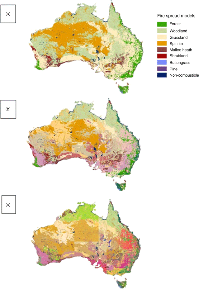
A new fire danger rating system was developed in Australia (the Australian Fire Danger Rating System, AFDRS) to address these concerns, and to take advantage of advances in fire science and meteorology in recent decades. This study documents the climatology of the Research Prototype (AFDRSRP) implementation of the AFDRS. The operational implementation of the AFDRS, which occurred in September 2022, represents a further development of the research prototype outlined here and in related articles. Eight fire spread models, supported by peer-reviewed science and amenable to calculation with readily available fuel and weather inputs, were selected to form the basis of the AFDRS (Matthews et al. 2019). The fuel types covered by these models include forest (Cheney et al. 2012), grass (Cheney et al. 1998), pine plantation (Cruz et al. 2008), buttongrass moorland (Marsden-Smedley and Catchpole 1995), semi-arid mallee-heath (Cruz et al. 2013), temperate shrubland (Anderson et al. 2015), northern grassland (Cheney and Sullivan 2008) and spinifex (Burrows et al. 2018). Some vegetation types were not accounted for by the eight fire spread models above, so were included with the closest available model and adjustments made to the implementation of the model; e.g. wet eucalypt forests used the dry forest model, but with fuel availability limited by a higher moisture content. This resulted in 23 secondary fuel classifications. A tertiary level accounts for spatial variation in fuel characteristics at a largely regional level. The fuel types formed the basis of a new, national fuel map for Australia (Kenny et al. 2024). Fig. 1 shows the three levels of classification ranging from the eight fire spread models to 378 fuel types. The fuel map underpins model implementation in the AFDRSRP, so the structures evident in the map propagate through the fire behaviour models to any climatology that is developed based on them. For example, abrupt changes evident at some jurisdictional boundaries in Fig. 1b, c result from differences in accounting of fuel age (time since last fire) between state and territory land managers across parts of Australia.
Australian fuel map in its three levels of detail (a) attribution of the eight fire spread models (b) breakdown of these models into 23 major fuel classifications (c) further refinement into 378 parameterised fuel types. A legend indicates fuel types in (a).
Historical atmospheric data provides a rich source of potential insights into behaviour of many natural phenomena and climatological studies can show broad characteristics and overall trends in that data. Climatologies of fire danger have been published in the past, particularly in Australia. Many of these are based on observational station data (Long 2006; Fox-Hughes 2008; Fox-Hughes 2011; Lucas 2010; Clarke et al. 2013). Dowdy et al. (2009, 2010) constructed an 8-year gridded climatology of the Canadian Fire Weather Index (FWI) component of the Canadian Fire Danger Rating System and McArthur Forest Fire Danger Index (FFDI) using numerical weather prediction model output. Dowdy (2018) published a gridded climatology of McArthur FFDI for the period 1950–2016, which has been used to place a number of recent extreme fire weather events into historical context (Bureau of Meteorology 2019a, 2019b, 2020). Louis (2014) published a reanalysis climatology of McArthur FFDI for New South Wales (NSW), Australia, generating return period estimates for FFDI across the domain. A number of climatologies have been constructed for North America (e.g. Andrews et al. 2003), with (Walding et al. 2018) comparing fire size and occurrence with NFDRS output. Freeborn et al. (2016) used a climatology based on an updated version of the US NFDRS to examine changes in fire activity in that country in recent decades, while Jolly and Freeborn (2017) related fire danger indices from the updated NFDRS to observed, categorical descriptions of fire danger rating category. Field et al. (2015) published a database of global fire danger, based on the Canadian FWI system, noting the development of earlier reanalysis-based datasets of the FWI system over regional (e.g. Chu and Guo 2014, for Siberia) and continental (Camia and Amatulli 2009, for Europe) domains. Several authors have extended such national or regional climatologies to construct global climatologies of fire danger indicators, based on a variety of indices and meteorological parameters (Jolly et al. 2015; Jain et al. 2022).
We describe a climatology of the AFDRSRP and highlight its major features, including median and high-decile geographic structure of the AFDRSRP. The climatology provides fire managers and meteorologists with an understanding of broad characteristics of the AFDRSRP, particularly in view of its impending operational implementation. More importantly, the climatology also permits an assessment of the appropriateness of fire danger rating thresholds within the system. Thus, for most locations and for most of the time, ratings should be relatively low, with the highest rating category restricted to a very small percentage of occasions across Australia. This is not to say that fires cannot occur frequently, particularly during typical fire seasons, but that rapidly spreading and high intensity fires are not observed frequently (for more details on observed characteristics of fires in each category, see Hollis et al. manuscript 2 in this series). Any departure from this distribution would prompt a review of the structure and application of the AFDRSRP.
In addition to new fire danger ratings the AFDRSRP specifies a set of warning flags indicating changing or unstable conditions conducive to increased fire activity, but which are not directly accounted for by the simple weather parameters used in the calculation of ratings. Of these the Continuous Haines Index (CHaines, Mills and McCaw 2010) is used as a measure of atmospheric instability and dryness conducive to increased fire activity. A flag is raised if daily peak CHaines exceeds the 95th percentile of historic values for a given location. To this purpose we also develop a climatology of CHaines.
The paper is structured as follows. We describe the generation of the climatology, combining the regional reanalysis with the AFDRSRP to produce the reanalysis climatology. In the results section, we describe some insights about spatial and temporal characteristics of the AFDRSRP and, in the discussion section, explore pathways to future progress before summarising the work.
Materials and methods
The AFDRSRP requires inputs of dynamic weather, fuel state and fire history as well as a fuel type grid that covers Australia. The outputs are a Fire Behaviour Index and a rating derived from the index indicating potential fire danger categorised into six levels (Grootemaat et al. 2024; Hollis et al. 2024). Index and category values were generated hourly, then summarised into daily and longer-term statistics, from January 2000 to February 2019.
Fuel state parameters
Fire history represented as years since last burn was required to drive fuel accumulation curves, in turn to calculate available fuel load as an input to fire behaviour models. The history was derived from historic burn data, and the fuel type grid from the AFDRSRP was used to delineate fuel types. Consistent historical data was available for the period 2003–2019. In order to construct an approximate 20-year climatology of the fire danger ratings; however, seasonal average fuel loads were derived from the available data commencing 2003 and used to backfill fuel load for the period 2000–2002, thereby allowing the climatology to extend from 2000 forward. Ideally, a climatology would extend for a longer period than approximately 20 years. Certainly, the required weather data is available for longer. However, sufficiently detailed fuel data has only been gathered and archived across Australia relatively recently.
Weather parameters
Meteorological parameters used in the climatology were obtained from the Bureau of Meteorology’s Atmospheric high-resolution Regional Reanalysis for Australia (BARRA: Su et al. 2019). BARRA is based on the Australian operational numerical weather prediction model ACCESS and provides the highest resolution available three-dimensional gridded historical dataset of the atmosphere over Australia. BARRA includes several datasets: BARRA-R is a regional (Australia plus surrounding territory) scale reanalysis, and several nested subdomains have also generated at higher resolution over priority subregions. BARRA-R was used for this analysis as it covers the period from January 1990 to February 2019 at 12 km horizontal and hourly temporal resolution over the entire Australian domain. However, due to the limit of available fire history grids, only the period from January 2000 to February 2019 was used for this study. While BARRA-R represents the historical atmosphere well, there are known biases. In particular, there is a generally small but consistent underestimation of higher wind speeds (Su et al. 2019), typical of numerical weather prediction models, which results in lower than realistic estimates of fire danger. Spatial and temporal patterns of fire danger are not expected to be affected.
To represent forest fuel availability to burn, Drought Factor (DF) was derived from the BARRA-R data as the latter represented the most consistent source of this data. DF calculations can employ several different precursor soil dryness metrics. Operationally, the Keetch-Byram Drought Index (KBDI, Keetch and Byram 1968) or the Mount Soil Dryness Index (MSDI, Mount 1972) are used in different jurisdictions within Australia. We use KBDI for consistency with other Australian climatological studies. In the operational definitions of DF (Griffiths 1999), a day is specified as 09:00–09:00 hours local time. However, as the climatology encompassed the whole of Australia, covering several time zones, 00:00–00:00 hours Coordinated Universal Time (UTC) was used to represent a single day. This is deemed acceptable as the resulting differences day to day are not relevant to the overall variability and climatology of AFDRSRP.
Satellite derived curing grids were drawn from the Bureau’s archives of operational data, stored at weekly intervals. Curing grids were derived based on the approach of Martin et al. (2015), using the MapVictoria (MapVic, described in Martin et al. 2015) algorithm to generate curing values. In cases where missing data points occurred in the archives (due to satellite obstruction by cloud), these were filled with a two-step method. First, interpolation was attempted from 3 weeks of data either side of the missing week and where this was not possible, the monthly mean value was used. This method was used after considering the approaches taken operationally by both the NSW Rural Fire Service (RFS), where new values are mosaiced over old, and the Victorian Country Fire Authority (CFA), where a spatial interpolation approach is used. As a more comprehensive dataset was available for the AFDRSRP than is generally the case for the operational fire agencies, the latter two-step method was chosen.
The spinifex fire spread model uses 0–10 cm soil moisture content to determine fuel availability. Modelled soil moisture data using the AWRA-L model were obtained for this purpose from the Australian Landscape Water Balance archive (Frost et al. 2018).
Table 1 summarises the data sources used in the calculation of the climatology.
| Grids | Resolution | Source | Notes | |
|---|---|---|---|---|
| Temperature (T) | Hourly, 1.5 km | Bureau of Meteorology’s high-resolution reanalysis BARRA-R | ||
| Temperature dewpoint (Td) | ||||
| Wind speed (Wmag) | ||||
| Precipitation (Precip) | ||||
| Drought Factor (derived using KBDI calculations) | ||||
| Curing | Weekly, 500 m | Bureau of Meteorology archives | Satellite derived MapVic curing | |
| Soil moisture | Daily, <1.5 km | Australian Landscape Water Balance (the Bureau) | 0–10 cm layer | |
| Grass fuel load | Time independent, 1.5 km | NSW Rural Fire Service | Assumed fuel loads based on general climate (6, 4.5, 2 t ha−1 for distinct climate regions) | |
| Time since fire (TSF) | Non regular time steps, 1.5 km | NSW Rural Fire Service (collated agency fire history archive) | Days since last fire event from grid time stamp, select grids throughout time period. Derived from fire occurrence database. | |
| Fuel type | Time independent, 1.5 km | NSW Rural Fire Service | Fuel type grid underpinning AFDRSRP calculations. (Kenny et al. 2024) |
The climatology grids were produced by calculating the AFDRSRP over the Australian region at the spatial resolution of the fuel type grids (1.5 km) and the hourly temporal resolution of the BARRA-R reanalysis dataset. The disparate data sources were resampled using greatest coverage to match the resolution and dimensions of the fuel type grids. For fuel state grids that were not available at hourly resolution the most recent grid was used. For example, grass curing was based on observations updated on a weekly basis. However, forest Drought Factor was updated every 3 h, at the resolution of precipitation grids, to account for the possibility of rainfall occurring and wetting that fuel type.
The hourly grids were summarised to generate a daily maximum of the Fire Danger Rating and Fire Behaviour Index, where a day was defined for this purpose between 15:00 hours and 15:00 hours UTC. The full set of daily maximum grids was then used to produce summary grids based on percentiles for different sub-yearly periods across the entire set of years. Percentiles were created using annual, seasonal and monthly time periods. Analyses focussed on 50th, 90th and 99th percentile maps.
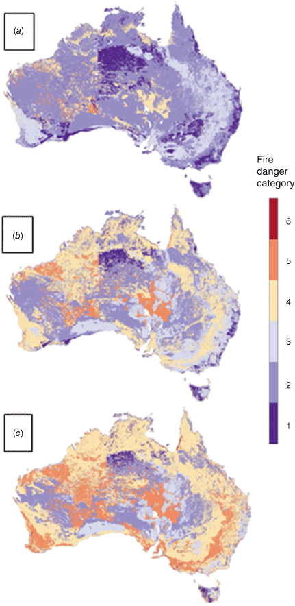
Percentile maps of daily maximum values of the AFDRSRP, over the Australian domain during the period 2000–2019, are presented to provide an overview of typically occurring values, and how these compare across Australia (Fig. 2). Thus, for example, the 90th percentile map of the AFDRSRP displays values at each grid point for which the daily maximum value will not be exceeded on 90% of days, if the 90th percentile value of the AFDRSRP is Category 5 at a grid location, the AFDRSRP rating should be no higher than five on nine days out of 10. The plots displayed are of the 50th, 90th and 99th percentile values of FDR.
Plots of (a) 50th, (b) 90th and (c) 99th percentile Fire Danger Rating for the 2000–2019 analysis period. Generally, as expected, areas of highest category are not very apparent even in the 99th percentile plot.
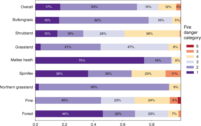
Plots of each percentile were further summarised into a category distribution plot (Fig. 3) for the entire region and for specific fuel types. These plots highlight the overall behaviour, sensitivity and distribution of the associated models.
Results
Fire danger percentiles
The structures that emerge from plots of the 50th, 90th and 99th percentiles of the AFDRSRP rating (Fig. 2) clearly reflect the underlying fuel map and highlight how divergent adjacent points can be, based on the respective underlying fire spread models. Of note with these plots is the low frequency of Category 6 and its concentration in certain areas. Overall, this is due to the lower sensitivity of most models and the infrequency of conditions that drive higher categories. The predominant areas of higher category are Pine, which the fire spread model distributions show to be the most sensitive of the models. Another region of this highest category is the southeast coast of the Gulf of Carpentaria, which is largely grassland and possibly exposed to higher windspeeds at critical times of the day compared to more inland locations. Areas of the interior of the country have low to no occurrence of higher categories. This reflects the broad, discontinuous distribution of vegetation in those areas and hence the lower likelihood of fire spread, reflected in the parameterisation of those points (Hollis et al. 2024; Kenny et al. 2024).
The climatology indicates that the AFDRSRP behaves as expected. Overall, the spatial and temporal distribution is heavily biased towards the lower categories, with fewer areas and times experiencing higher ratings. The distinct models follow the overall trend but also highlight different sensitivities.
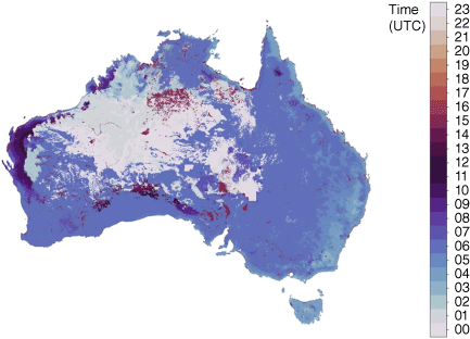
Diurnal timing
Hourly resolution of the Fire Behaviour Index permits examination of the mode hour of maximum time (in Mean Solar Time) by plotting the fire spread model distribution of hour of maximum (Fig. 4). Note that during the summer months, Australia (excluding offshore islands, which potentially add another three) is subject to five time zones. Use of MST to indicate time across the 40° of longitude encompassed by continental Australia best represents the impact of diurnal insolation across the landscape, as MST aligns with the movement of the sun across the sky at each location. Several points of interest emerge from these plots. Most models fit a widely assumed early afternoon peak (McArthur 1967; Fox-Hughes 2011) with a notable exception of Spinifex which has an abrupt peak in the morning and gradually tapers off. The morning peak is likely to be of interest to operational land managers, and would repay further investigation to ascertain which of the underlying model parameters (or combination of parameters) is driving it. As spinifex is an arid land vegetation type, soil moisture content in such environments is frequently low and the relative humidity can quickly drop as the air warms. Also, mallee-heath is frequently insensitive to conditions typically experienced over the course of a day. As such, fire danger conditions experienced at 15:00 UTC (the uniform start of a day for calculation of AFDRSRP across Australia) are often the highest experienced at any time during the ensuing day. That time (15:00 hours UTC) corresponds to 23:00 hours MST, with a strong but misleading peak displayed for this fuel type at that time. The peak is shown in grey in Fig. 4, to alert readers to the fact that the peak is not related to diurnal variation, but to the choice of the start of a day.
Distributions of hour of maximum Fire Behaviour Index grouped by fire spread model. Hours are in Mean Solar Time. Red bars denote relative maxima (compared to surrounding times) of Fire Behaviour Index.
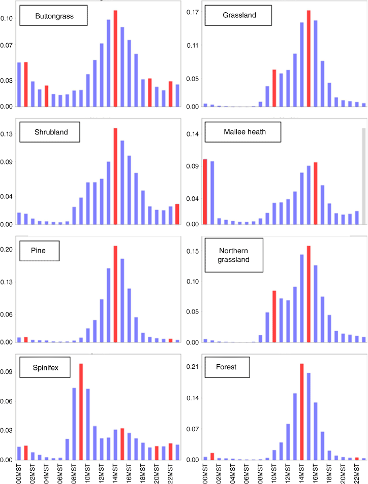
Of additional interest are the models that have little sensitivity at night (Grassland, Pine, Northern Grassland (savannah) and Forest) versus those that show some signal (Buttongrass, Shrubland, Mallee-Heath) reflecting their relative sensitivity to temperature and relative humidity.
Fig. 5 shows the mode hour of maximum fire danger across Australia. The early afternoon maximum, as mentioned above, can be seen across the country, varying to a degree with time zones (03:00 hours UTC/14:00 hours Local Summer Time in the east to 06:00 hours UTC/14:00 hours Local Time in the west), but strongly influenced by elevation in the east, proximity to the coast and, as highlighted above by fuel type. Of note, large differences are evident in the behaviour of some fuel types. This is particularly the case, as noted above, given that Spinifex fire danger typically peaks in the morning (Fig. 4), and occurs preferentially in the arid interior of Australia. Of interest are continuous regions of often a single vegetation type with distinct variations in the modal hour of maximum fire danger. This reflects differences in the climatology of the respective regions. For example, a distinct feature occurs in uniform vegetation inland of the north-west Western Australian coast. Fire danger peaks most commonly between 09:00 hours and 11:00 hours UTC (late afternoon to early evening) in this region. The feature occurs across multiple vegetation types (mainly Northern Grassland and Spinifex) and so is more likely a product of local weather phenomena, potentially a combination of inland winds and higher temperatures compared to the coast. It is outside the scope of this paper but would be of interest to investigate further.
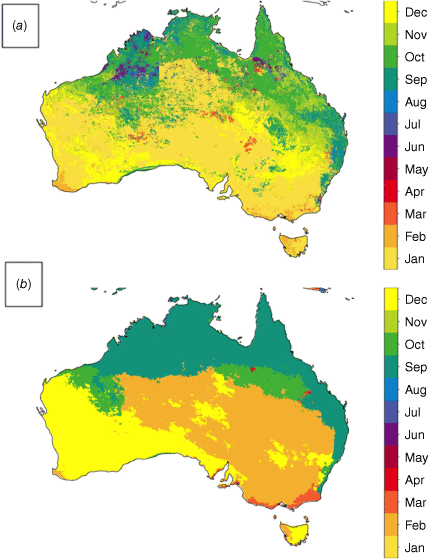
Month of peak danger
The month of peak fire danger is determined by calculating the monthly mean daily maximum fire danger then selecting the month with the highest mean. The resulting plot (Fig. 6a) reflects established seasonal ranges and corroborates McArthur’s plots of seasonal fire danger (Luke and McArthur 1978), although with greater detail. Months of peak fire danger vary from December to January in the south and October–November in the north. This overall pattern differs notably on the east coast as the Great Dividing Range running inland of the coast (north to south) modifies the local climate in these areas (a characteristic that is reflected in the fuel map). In addition, many variations are driven by differences in fuel types and subtle variations in climate. Some reflect differences in the categorisation of fuels, despite efforts to harmonise vegetation characterisation across jurisdictional boundaries. For example, there is a clearly artificial boundary in the north-west of the map (Fig. 6), associated with the border between Western Australia and the Northern Territory. This is caused by a subtle difference in the parametrisation of Spinifex vegetation across the administrative boundary (Fig. 1c).
Continuous Haines index
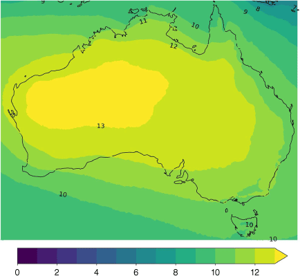
The Continuous Haines Index (CHaines) is an indicator of atmospheric instability used operationally in some parts of Australia. An extension of the Haines Index, it also flags atmospheric instability and the potential for abrupt decreases in relative humidity as dry air mixes down towards the surface, potentially resulting in rapid increases in fire activity (Mills and McCaw 2010). The AFDRSRP uses CHaines as an additional indicator of fire danger by flagging when the predicted CHaines exceeds the climatological 95th percentile of daily maxima. Initially such values had only been derived with lower resolution atmospheric models spanning a period of less than a decade to provide indicative estimates of typical CHaines for several locations in Australia. Dowdy and Pepler (2018) developed a spatially comprehensive Australian climatology of CHaines based on ERA-Interim reanalysis (Dee et al. 2011) between 1979 and 2016, using the 06:00 UTC timestep as representative of peak afternoon fire weather conditions. The higher spatial resolution and hourly temporal resolution of BARRA-R offered an opportunity to better resolve variability of CHaines in both time and space. For this reason, the 1990–2019 BARRA-R dataset was used to develop a climatology of CHaines using hourly data from which daily maximum CHaines was computed. A map of 95th percentile daily maximum CHaines was then derived from these data.
Plots of 95th percentile daily maximum CHaines and mode hour of maximum CHaines are in Figs 7 and 8, respectively. The values for the 95th percentile daily maximum plot largely agree with figures from Mills and McCaw (2010), and those in Dowdy and Pepler (2018). In each case, values of 95th percentile daily maximum CHaines are around 10 on the east coast of Australia and 13 in the western interior of the continent.
CHaines mean hour of maximum for values above the 95th percentile. Values above the 95th percentile are relevant to assessing contributing atmospheric instability to fire danger. These timings indicate the peak instability for this range of CHaines tends to occur between the local morning to early afternoon.
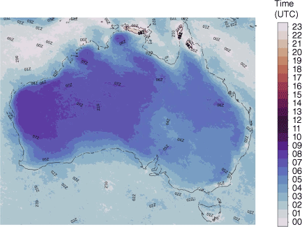
The timing of daily maximum CHaines, for values above the 95th percentile of daily maxima (Fig. 8), is of particular interest as this has not been investigated before. The hourly resolution of BARRA-R permits close observation of typical diurnal variability in this quantity. Mean times of diurnal peaks range from 00:00 hours to 05:00 hours UTC (local time 08:00–13:00 hours in the west and 10:00–14:00 hours in the east) and can be seen to broadly follow the general shape of the 95th percentile value map with areas in the western interior ranging up to 05:00 hours UTC (13:00 hours local time) and the eastern and southern coastal areas peaking at 01:00 hours UTC (11:00 hours local time). These patterns do not reflect a consistent local time peak across the continent but instead indicate that diurnal surface heating is only one factor in the occurrence of peak values.
Discussion
This paper has presented a subset of results from a climatology of the AFDRSRP. It is important to note that these results are a snapshot of the Research Prototype of the AFDRS, and not its operational implementation. The system is designed to be tuned based on observations of fire events so that over time, it will evolve to more accurately predict the danger associated with real events. However, many of the broad characteristics resulting from this study provide good instruction on the overall behaviour of the system and thus will prove valuable in training and decision-making processes in fire management.
The greatest departure in the AFDRSRP from previous fire danger rating systems is the application of more fire spread models as an alternative to McArthur FFDI and GFDI. This is most clearly seen in the fuel type map and the patterning that occurs in all resultant maps. The climatology presented here is a strong departure from previous climatologies of fire danger in Australia that focused solely on the FFDI and hence, resulted in clearer and simpler outcomes but which spoke more to the climate in an area than directly to its fire danger. Vegetation is rarely uniform thus the fuel type map makes the AFDRSRP a much more realistic tool for fire managers. Inevitably, the fuel type map will not prove to be fully accurate in parts of the country. However it and other aspects of the AFDRSRP are designed to be updated and refined as the system evolves.
Investigation of the climatology of the AFDRSRP fire danger rating categories indicates that the system accords broadly to observation and the expectation of fire managers. It also highlights areas that have greater or lesser propensity to higher categories together with corresponding vegetation types. The variation in sensitivity and response of various vegetation types is a direct reflection of the fire spread models used and so is not surprising in itself. However, it is the first time this variation has been mapped and hence provides an enhanced awareness of the distribution of fire danger across Australia. An interesting adjunct to this result would be to investigate how it corroborates with experiential knowledge of regions of extreme fire danger. With the current level of validation these maps provide useful tools for fire managers to know where best to focus resources in fire-management scenarios. Additionally, although the individual models have been empirically derived and hence reflect the observed behaviour of the associated fuel type, the distributions of categories (Fig. 2) show how these models are modulated by the overall climate in which they occur. Hence the relative danger of a particular vegetation type may be attenuated by the local climate in its endemic region.
The results of the diurnal variability aspect of the study are of particular interest as they challenge the common assumption that peak fire danger occurs in the early afternoon. Clearly, this is not the case for all vegetation types and sub-climates, indicating that it is essential in decision making to be aware of typical diurnal characteristics of the types of vegetation burning and the corresponding indicated behaviour, together of course with the variability in weather conditions. Other studies indicate that the effects of elevation result in different patterns of diurnal variability in peak fire danger (Fox-Hughes et al. 2019). The variations in peak timing within each vegetation type (Fig. 4) would reward greater exploration, especially in understanding the behaviour of fuel types that do not conform to an afternoon peak (Spinifex and Northern Grassland) to pinpoint drivers of this behaviour. Further, the timing of maximum CHaines also indicates that potential dramatic changes in atmospheric conditions due to instability and dryness may occur outside of peak fire danger timing, emphasising the need to assess each situation carefully.
In this paper, we focussed on broad features of the climatology of AFDRS across the entirety of Australia. It is clear that the climatology is strongly dependent on fuel type (discussed further below). It differs in that respect from the previous operational system(s) used in Australia, which treated forest and grassland separately rather than attempting to integrate them into a single fire danger rating system. The previous system also largely did not deal with other vegetation types. We have not, however, systematically reported the sensitivity of the AFDRS to individual weather parameters such as wind speed or relative humidity. This is clearly of interest and important both to fire managers and meteorologists dealing with fire. Sensitivity to weather parameters, particularly wind, of individual fire behaviour models is documented in Matthews et al. (2019), but is outside the scope of this work. A climatology such as that discussed here is of considerable value to fire managers, placing current and forecast conditions in historical context. As a simple example, time series of AFDRS Fire Behaviour Index for a site can be plotted against backgrounds displaying frequency thresholds such as 90th or 95th percentile daily maximum values.
Finally, we briefly discuss the validity of these results and the interplay between the fuel map and climate. The fuel type map itself is strongly driven by climatology as the long-term effects of climate will encourage the growth of vegetation adapted to local long-term conditions. As such vegetation becomes established, it in turn can have subtle effects on climate. Hence in looking at the fuel map, areas of mountain and desert, inland and coastal areas can all be seen reflected in the fuels that are best acclimatised to those conditions. This also highlights that any climatology produced using the fuel type map is only valid for as long as both the climate and general vegetation types are consistent. Any major events that drastically affect an area may result in a change in the types of vegetation that occur there having flow on effects to the microclimate of the area and hence its response to weather conditions (Wendt et al. 2007; Veraverbeke et al. 2012; Beringer et al. 2015). Clear examples of this are long-term drought or large-scale fire events that drastically alter the landscape of an area, turning it, for example, from scrub to desert or forest to scrub. Such events would require changes in the fuel maps and would make the climatology results for those areas less valid. A strength of the AFDRS is that it can evolve to reflect these changes.
Data availability
Weather data that support this study are available from the Australian National Computational Infrastructure (NCI). Fuel data that support this study were obtained from Australian fire agencies by permission/licence. Data will be shared upon reasonable request to the corresponding author with permission from the Australasian Fire and Emergency Service Authorities Council.
Declaration of funding
This work was funded by grants from the Australian Government’s National Emergency Management Projects programme and the NSW Rural Fire Service’s Bush Fire Risk Mitigation and Resilience Programme. The project received considerable in-kind support from the Bureau of Meteorology and the NSW Rural Fire Service. This research/project was also undertaken with the assistance of resources and services from the National Computational Infrastructure (NCI), which is supported by the Australian Government. Support for the publication of this article was provided by the Australian Climate Service.
Author contributions
S. Sauvage: formal analysis, literature review, original draft. P. Fox-Hughes: conceptualisation, literature review. S. Matthews: project oversight and lead. All authors contributed to the system development, writing, review and editing of this paper.
References
Anderson WR, Cruz MG, Fernandes PM, McCaw L, Vega JA, Bradstock RA, Fogarty L, Gould J, McCarthy G, Marsden-Smedley JB, Matthews S, Mattingley G, Pearce HG, van Wilgen BW (2015) A generic, empirical-based model for predicting rate of fire spread in shrublands. International Journal of Wildland Fire 24, 443-460.
| Crossref | Google Scholar |
Andrews PL, Loftsgaarden DO, Bradshaw LS (2003) Evaluation of fire danger rating indexes using logistic regression and percentile analysis. International Journal of Wildland Fire 12, 213-226.
| Crossref | Google Scholar |
Beringer J, Hutley LB, Abramson D, Arndt SK, Briggs P, Bristow M, Canadell JG, Cernusak LA, Eamus D, Edwards AC, Evans BJ, Fest B, Goergen K, Grover SP, Hacker J, Haverd V, Kanniah K, Livesley SJ, Lynch A, Maier S, Moore C, Raupach M, Russell-Smith J, Scheiter S, Tapper NJ, Uotila P (2015) Fire in Australian savannas: from leaf to landscape. Global Change Biology 21, 62-81.
| Crossref | Google Scholar | PubMed |
Bureau of Meteorology (2019a) Special Climate Statement 71—severe fire weather conditions in southeast Queensland and northeast New South Wales in September 2019. (Melbourne, Australia). Available at http://www.bom.gov.au/climate/current/statements/scs71.pdf [verified 01 November 2021]
Bureau of Meteorology (2019b) Special Climate Statement 72— dangerous bushfire weather in spring 2019. (Melbourne, Australia). Available at http://www.bom.gov.au/climate/current/statements/scs72.pdf [verified 01 November 2021]
Bureau of Meteorology (2020) Special Climate Statement 73—extreme heat and fire weather in December 2019 and January 2020. (Melbourne, Australia). Available at http://www.bom.gov.au/climate/current/statements/scs73.pdf [verified 20 February 2024]
Burrows N, Gill M, Sharples J (2018) Development and validation of a model for predicting fire behaviour in spinifex grasslands of arid Australia. International Journal of Wildland Fire 27, 271-279.
| Crossref | Google Scholar |
Cheney NP, Gould JS, Catchpole WR (1998) Prediction of fire spread in grasslands. International Journal of Wildland Fire 8, 1-13.
| Crossref | Google Scholar |
Cheney NP, Gould JS, McCaw WL, Anderson WR (2012) Predicting fire behaviour in dry eucalypt forest in southern Australia. Forest Ecology and Management 280, 120-131.
| Crossref | Google Scholar |
Chu T, Guo X (2014) An assessment of fire occurrence regime and performance of Canadian fire weather index in south central Siberian boreal region. Natural Hazards and Earth System Sciences Discussions 2, 4711-4742.
| Crossref | Google Scholar |
Clarke H, Lucas C, Smith P (2013) Changes in Australian fire weather between 1973 and 2010. International Journal of Climatology 33, 931-944.
| Crossref | Google Scholar |
Cruz MG, Alexander ME, Fernandes PAM (2008) Development of a model system to predict wildfire behaviour in pine plantations. Australian Forestry 71, 113-121.
| Crossref | Google Scholar |
Cruz MG, McCaw WL, Anderson WR, Gould JS (2013) Fire behaviour modelling in semi-arid mallee-heath shrublands of southern Australia. Environmental Modelling & Software 40, 21-34.
| Crossref | Google Scholar |
Dee DP, Uppala SM, Simmons AJ, Berrisford P, Poli P, Kobayashi S, Andrae U, Balmaseda MA, Balsamo G, Bauer P, Bechtold P, Beljaars ACM, van de Berg L, Bidlot J, Bormann N, Delsol C, Dragani R, Fuentes M, Geer AJ, Haimberger L, Healy SB, Hersbach H, Hólm EV, Isaksen L, Kållberg P, Köhler M, Matricardi M, McNally AP, Monge‐Sanz BM, Morcrette J-J, Park B-K, Peubey C, de Rosnay P, Tavolato C, Thépaut J-N, Vitart F (2011) The ERA-Interim reanalysis: configuration and performance of the data assimilation system. Quarterly Journal of the Royal Meteorological Society 137, 553-597.
| Crossref | Google Scholar |
Dowdy AJ (2018) Climatological variability of fire weather in Australia. Journal of Applied Meteorology and Climatology 57, 221-234.
| Crossref | Google Scholar |
Dowdy AJ, Pepler A (2018) Pyroconvection risk in Australia: climatological changes in atmospheric stability and surface fire weather conditions. Geophysical Research Letters 45, 2005-2013.
| Crossref | Google Scholar |
Dowdy AJ, Mills GA, Finkele K, De Groot W (2009) Australian fire weather as represented by the McArthur Forest Fire Danger Index and the Canadian Forest Fire Weather Index. CAWCR Technical Report No. 10. (Centre for Australian Weather and Climate Research, Bushfire Cooperative Research Centre and Canadian Forest Service) Available at http://www.bushfirecrc.com/publications/citation/bf-3549 [verified 1 November 2021]
Dowdy AJ, Mills GA, Finkele K, de Groot W (2010) Index sensitivity analysis applied to the Canadian Forest Fire Weather Index and the McArthur Forest Fire Danger Index. Meteorological Applications 17, 298-312.
| Crossref | Google Scholar |
Field RD, Spessa AC, Aziz NA, Camia A, Cantin A, Carr R, de Groot WJ, Dowdy AJ, Flannigan MD, Manomaiphiboon K, Pappenberger F, Tanpipat V, Wang X (2015) Development of a Global Fire Weather Database. Natural Hazards and Earth System Sciences. 15, 1407-1423.
| Crossref | Google Scholar |
Fox-Hughes P (2008) A fire danger climatology for Tasmania. Australian Meteorological Magazine 57(2), 109-120.
| Google Scholar |
Fox-Hughes P (2011) Impact of more frequent observations on the understanding of Tasmanian fire danger. Journal of Applied Meteorology and Climatology 50, 1617-1626.
| Crossref | Google Scholar |
Fox-Hughes P, Sauvage S, Matthews S, Kenny BJ, Hollis JJ, Grootemaat S, Jakob D, Su CH, Eizenberg N, Steinle P (2019) Changes in the diurnal cycle of fire danger with elevation in Tasmania: the old and the new. In ‘6th International Fire Behavior and Fuels Conference’, April 29–May 3 2019, Sydney, Australia. (International Association of Wildland Fire: Missoula, MT, USA)
Freeborn PH, Jolly WM, Cochrane MA (2016) Impacts of changing fire weather conditions on reconstructed trends in U.S. wildland fire activity from 1979 to 2014. Journal of Geophysical Research: Biogeosciences 121, 2856-2876.
| Crossref | Google Scholar |
Frost AJ, Ramchurn A, Smith A (2018) The Australian Landscape Water Balance model (AWRA-L v6). Technical Description of the Australian Water Resources Assessment Landscape model version 6. Bureau of Meteorology Technical Report. (Melbourne, Australia) Available at http://www.bom.gov.au/water/landscape/assets/static/publications/AWRALv6_Model_Description_Report.pdf [Verified 01 November 2021].
Griffiths D (1999) Improved formula for the drought factor in McArthur’s Forest Fire Danger Meter. Australian Forestry 62, 202-206.
| Crossref | Google Scholar |
Grootemaat S, Matthews S, Kenny BJ, Runcie J, Hollis JJ, Sauvage S, Fox-Hughes P, Holmes A (2024) Live trial performance of the Australian Fire Danger Rating System - Research Prototype. International Journal of Wildland Fire, In press.
| Crossref | Google Scholar |
Hollis JJ, Matthews S, Anderson WR, Cruz MG, Fox-Hughes P, Grootemaat S, Kenny BJ, Sauvage S (2024) A framework for defining fire danger to support fire management operations in Australia. International Journal of Wildland Fire, In press.
| Crossref | Google Scholar |
Jain P, Castellanos-Acuna D, Coogan SCP, Abatzoglou JT, Flannigan MD (2022) Observed increases in extreme fire weather driven by atmospheric humidity and temperature. Nature Climate Change 12, 63-70.
| Crossref | Google Scholar |
Jolly WM, Freeborn PH (2017) Towards improving wildland firefighter situational awareness through daily fire behaviour risk assessments in the US Northern Rockies and Northern Great Basin. International Journal of Wildland Fire 26, 574-586.
| Crossref | Google Scholar |
Jolly WM, Cochrane MA, Freeborn PH, Holden ZA, Brown TJ, Williamson GJ, Bowman DM (2015) Climate-induced variations in global wildfire danger from 1979 to 2013. Nature Communications 6, 7537.
| Crossref | Google Scholar | PubMed |
Kenny BJ, Matthews S, Sauvage S, Grootemaat S, Hollis JJ, Fox-Hughes P, Runcie J, Holmes A (2024) Australian Fire Danger Rating System: implementing fire behaviour calculations to forecast fire danger in a research prototype. International Journal of Wildland Fire, In press.
| Crossref | Google Scholar |
Long M (2006) A climatology of extreme fire weather days in Victoria. Australian Meteorological Magazine 55, 3-18.
| Google Scholar |
Louis S (2014) Gridded return values of McArthur forest fire danger index across New South Wales. Australian Meteorological and Oceanographic Journal 64, 243-260.
| Crossref | Google Scholar |
Lucas C (2010) On developing a historical fire weather data-set for Australia. Australian Meteorological and Oceanographic Journal 60, 1-14.
| Crossref | Google Scholar |
Marsden-Smedley J, Catchpole W (1995) Fire behaviour modelling in Tasmanian buttongrass moorlands. II. Fire behaviour. International Journal of Wildland Fire 5, 215-228.
| Crossref | Google Scholar |
Martin D, Chen T, Nichols D, Bessell R, Kidnie S, Alexander J (2015) Integrating ground and satellite-based observations to determine the degree of grassland curing. International Journal of Wildland Fire 24, 329-339.
| Crossref | Google Scholar |
Su C-H, Eizenberg N, Steinle P, Jakob D, Fox-Hughes P, White C, Rennie S, Franklin C, Dharssi I, Zhu H (2019) BARRA v1.0: The Bureau of Meteorology Atmospheric high-resolution Regional Reanalysis for Australia. Geoscientific Model Development 12, 2049-2068.
| Crossref | Google Scholar |
Veraverbeke S, Verstraeten WW, Lhermitte S, Van De Kerchove R, Goossens R (2012) Assessment of post-fire changes in land surface temperature and surface albedo, and their relation with fire–burn severity using multitemporal MODIS imagery. International Journal of Wildland Fire 21, 243-256.
| Crossref | Google Scholar |
Viegas DX, Bovio G, Ferreira A, Nosenzo A, Sol B (1999) Comparative study of various methods of fire danger evaluation in southern Europe. International Journal of Wildland Fire 9, 235-246.
| Crossref | Google Scholar |
Walding NG, Williams HTP, McGarvie S, Belcher CM (2018) A comparison of the US National Fire Danger Rating System (NFDRS) with recorded fire occurrence and final fire size. International Journal of Wildland Fire 27, 99-113.
| Crossref | Google Scholar |
Wendt CK, Beringer J, Tapper NJ, Hutley LB (2007) Local boundary-layer development over burnt and unburnt tropical savanna: an observational study. Boundary-Layer Meteorology 124, 291-304.
| Crossref | Google Scholar |
Willis C, van Wilgen B, Tolhurst K, Ererson C, D’Abreton P, Pero L, Fleming G (2001) ‘The development of a National Fire Danger Rating System for South Africa.’ (Prepared for Department of Water Affairs and Forestry, Pretoria by CSIR Water, Environment and Forestry Technology: Pretoria, South Africa)