

Using transboundary wildfire exposure assessments to improve fire management programs: a case study in Greece
Palaiologos Palaiologou A E , Alan A. Ager B , Max Nielsen-Pincus C , Cody R. Evers C and Kostas Kalabokidis D
A USDA Forest Service International Visitor Program, Oregon State University, Department of Forest Engineering, Resources and Management, 2150 SW Jefferson Way, Corvallis, OR 97331, USA.
B USDA Forest Service, Rocky Mountain Research Station, Missoula Fire Sciences Laboratory, 5775 US Highway 10W, Missoula, MT 59808, USA.
C Portland State University, Department of Environmental Sciences and Management, 1719 SW 10th Ave, Portland, OR 97201, USA.
D University of the Aegean, Department of Geography, University Hill, Mytilene, Lesvos Island, 81100, Greece.
E Corresponding author. Email: palaiologou.p@aegean.gr
International Journal of Wildland Fire 27(8) 501-513 https://doi.org/10.1071/WF17119
Submitted: 12 August 2017 Accepted: 27 June 2018 Published: 23 July 2018
Journal compilation © IAWF 2018 Open Access CC BY-NC-ND
Abstract
Numerous catastrophic wildfires in Greece have demonstrated that relying on fire suppression as the primary risk-management strategy is inadequate and that existing wildfire-risk governance needs to be re-examined. In this research, we used simulation modelling to assess the spatial scale of wildfire exposure to communities and cultural monuments in Chalkidiki, Greece. The study area typifies many areas in Greece in terms of fire regimes, ownership patterns and fire-risk mitigation. Fire-transmission networks were built to quantify connectivity among land tenures and populated places. We found that agricultural and unmanaged wildlands are key land categories that transmit fire exposure to other land tenures. In addition, fires ignited within protected lands and community boundaries are major sources of structure exposure. Important cultural monuments in the study area had fairly low exposure but higher potential for fires with moderate to high intensity. The results show how the spatial diversity of vegetation and fuels, in combination with vegetation management practices on private and public tracts of land, contribute to transboundary risk. We use the results to motivate a discussion of integrating transboundary risk assessments to improve the current wildfire-risk rating system and begin the process of reforming risk governance in Greece.
Additional keywords: communities, fire simulation modelling, fuel: treatments, policy.
Introduction
The growing problem of wildfires in Greece parallels much of the Mediterranean region. Civil protection agencies confront at least two large scale wildfires each year along with hundreds of medium- and thousands of small-scale events. During the summer–autumn of 2007, tens of concurrent large-scale wildfires, ranging from 10 000 to 40 000 ha, burned more than 270 000 ha in Greece. The 15 000-ha Chios Island fire in 2012 burned one sixth of the island, devastating part of the local economy and forested ecosystems. These extreme fire events are occurring with increasing frequency owing to climate anomalies (Koutsias et al. 2012; Karali et al. 2014), fuel build-up (Tsitsoni 1997; Kavvadias et al. 2001; Triantakonstantis et al. 2006) and rugged terrain around some urban development that hinders effective suppression activities.
Adapting to escalating wildfire problems in Greece is a complex risk-governance problem. Existing policies governing fuel management and use of prescribed fire as a fuel treatment have seen only minor adjustments during the past 45 years. Although the national responsibility for wildfire-risk management is coordinated by the General Secretary of Civil Protection (GSCP), a patchwork of agencies and national policies shape the short- and long-term response to wildfire (Morehouse et al. 2011; Sapountzaki et al. 2011). For instance, wildland fuel-reduction efforts are managed by the Greek Forest Service, whereas fuels reduction in and around communities is the responsibility of the municipalities. Fire suppression is carried out by a variety of actors, including the Fire Service (as the main agency), Hellenic Air Force, Greek Army and Volunteer Firefighting Forces, each under the coordination of GSCP (Xanthopoulos 2004). The bulk of the government expenditures are dedicated to fire suppression (~US$410 million per year to the Fire Service) (Hellenic Republic MoI 2016), with minor funding for fuel management and ignition prevention programs to the Forest Service ($2.5 million per year) and municipalities ($21 million per year). Despite the unbalanced funding of suppression compared with prevention, when multiple events occur concurrently under extreme weather, suppression resources are inadequate, especially in rugged or isolated locations, resulting in large-scale fire events that cross a large number of land tenures, fuel conditions and municipalities. Even in countries like France, where aggressive fire suppression policies like ‘Vulcain’ managed to reduce the number of fires and burned area by 50% since 1994, suppression failures in 2003 and 2016 demonstrate that relying on suppression is not a robust risk-management strategy (Curt and Frejaville 2017).
Ramping up fuel management to facilitate the existing suppression efforts is constrained by a host of socioeconomic regulatory factors. First, fuel reduction is regulated by the Greek Forest Service on both state (65% of all forests) and large privately owned forested lands. Private forest landowners are required to conduct detailed management plans for mechanical treatments and are prohibited from using prescribed fire (Law 998/1979, 16–4). These constraints, combined with a lack of funding, has all but precluded fuel-management activities on the majority of forested area. On state lands, forest management focuses on harvesting for commercial timber production, primarily in higher elevation ecosystems, leaving the more fire-prone low elevation pine forests and evergreen shrublands largely unmanaged and prone to fuel build-up (Xanthopoulos 2004). Coordination of fuel management between state and non-forested private lands is limited. In general, the current prioritisation scheme focuses on small-scale, scattered fuel-management projects around the wildland–urban interface (WUI), infrastructure and other valued resources (Henderson et al. 2005; Xanthopoulos et al. 2006; Kalabokidis et al. 2008) (Law 998/1979, 25–1).
Compounding the fuels-management problem is the practice of illegally setting fires to convert Mediterranean shrublands to agricultural lands and improve forage (Papanastasis 2004). Until the early 2000s, various laws allowed landowners to reclassify burned forests as ‘non-forest’ lands, thereby removing many administrative restrictions on land use (Laws 1734/1987 and 3208/2003). The lack of a national cadastre motivated landowners to use fire in this way to encroach on public or disputed forested lands and thus, increase landscape fragmentation.
Improving wildfire-risk governance in Greece will require a deep analysis of the socioecological drivers of fire such as land ownership, land use and fuel distribution, institutional diversity, and divergent attitudes towards wildfire risk (Xanthopoulos et al. 2006; Moreira et al. 2011). The centralised fire-management institution manages wildfire over a highly decentralised landscape of parcels managed by people with divergent views about risk and the need to take actions (Morehouse et al. 2011). Large fires span thousands of land parcels and individual landowners lack the understanding of how their management activities, or lack thereof, affect large-fire events in terms of spread and burn probability. Prior studies on this interdependence of land fragmentation and fire risk have explored how positive spatial externalities can result from collaborative fuel treatments (i.e. when one landowner undertakes fuel treatment, nearby landowners enjoy the benefits of lower fire risk) (Butry and Donovan 2008; Konoshima et al. 2008; Crowley et al. 2009; Busby et al. 2012, 2013; Fischer and Charnley 2012). Landscape fragmentation leads to inefficiency of fire-risk management (Busby et al. 2012; Salis et al. 2018), because cooperation among different landowners is influenced by lack of funding, contrasting interests, poor management culture and motivation. Negative externalities are also generated when private landowners do not bear the direct cost of fire suppression on their property, reducing the likelihood of engaging in collaborative fuel treatments (Crowley et al. 2009). Although many of these studies are conducted on artificial landscape and theoretical treatments of the problem, they all re-enforce the problem that both land and governance fragmentation slowly adapt to changing fire regimes. Moreover, the defragmentation process requires that land management organisations and private landowners fully understand the extent to which fire is a shared risk and requires collective action as afforded by a risk governance that respects the scale of large fire events.
In this study, we used wildfire-simulation modelling to disentangle how fire spreads through a diverse array of land tenures and communities in a highly fire prone region of Greece. The work demonstrates the magnitude of shared wildfire exposure on a typical fragmented landscape in northern Greece (Chalkidiki). We estimated wildfire transmission among land tenures and identified those tenures that contributed wildfire exposure to communities, tourism sites and important medieval monuments. The results were used as a foundation to discuss improvements to existing wildfire risk-governance policies and to prioritise communities for fire protection and fuel treatments.
Methods
Study area and land tenures
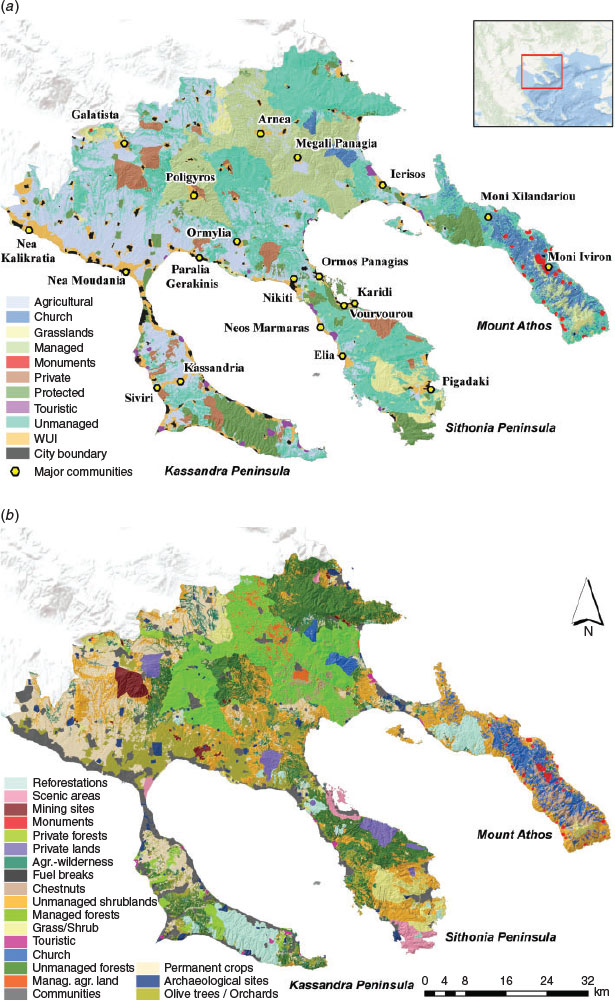
The study area of Chalkidiki (3250 km2) is a province located in northern Greece and is formed by three elongated peninsulas (Kassandra, Sithonia and Mount Athos). Approximately 100 000 people live in the area year-round, but that number grows to over 500 000 people during the tourism period in the summer. Based on the 2011 census data, Chalkidiki contains 173 communities, with 42 monasteries or small-scale monastic communities (skites) in Mount Athos (Fig. 1a). There are also 23 major tourism residential areas (defined as ‘touristic’ land tenure), mostly hotel complexes and camping sites. Of the 77 000 structures in the region, 30 000 are located in the WUI (Fig. 1a).
|
The most common economic activities in Chalkidiki are tourism, agriculture, beekeeping, mining and logging. Major stakeholders include private landowners, farmers, the church, mining companies, state (Forest Service, Archaeological Service, municipalities, etc.), and tourism businesses (Fig. 1a). Chalkidiki was classified into 10 major and 21 secondary land tenure groups based on ownership and management type (e.g. protected, managed) (Fig. 1, Table 1).

|
Approximately 750 km2 (23% of the study area) of Chalkidiki are privately owned agricultural lands (Fig. 1b). These lands are often mixed with wild vegetation due to land abandonment in areas around villages. Unmanaged forests are mostly of mixed ownership and vegetation composition (1100 km2, 33% of the study area) (Table 1). Widespread managed forests cover 15.5% of the study area (450 km2), the majority of which are owned and managed by the state. Private forest (50 km2, 1.5%) management is supervised by the Forest Service in collaboration with their owners. Protected lands cover 8% of Chalkidiki (260 km2), defined as those areas with an official legal-protection status by a state agency, primarily owned or managed by state agencies, church authorities and municipalities. Their management plans allow only minor interventions on small parts to avoid disturbances. Grasslands are usually owned by municipalities and livestock farmers, located mostly on the southern part of Sithonia and Mount Athos peninsulas (130 km2, 4%). Finally, communities with their WUI cover 7% of the study area (225 km2).
Part of this study is focussed on assessing the exposure of medieval monastic communities located in the peninsula of Mount Athos (370 km2). Mount Athos is an autonomous area entirely owned by the Greek Orthodox Church (hereafter referred to as ‘Church’), inhabited by ~2000 monks and is declared a UNESCO World Heritage site. Large parts of Church lands on Mount Athos were categorised into more detailed land tenures (e.g. into unmanaged or agricultural) whenever that was possible (i.e. sufficient detailed data), to avoid having only one land tenure for the entire peninsula. All lands on the Mount Athos peninsula without a detailed land-tenure characterisation, along with some lands on Chalkidiki’s mainland, constitute the ‘Church’ land tenure (4% of the entire study area). Church authorities apply forest-management plans in collaboration with the Greek Forest Service.
Chalkidiki has a range of different vegetation types and fuel conditions, typical of the Mediterranean region (Tables 1, S3). The central part is mainly covered by broadleaf and oak forests at higher elevations, and agricultural land on the plains. The Kassandra (west) and Sithonia (middle) peninsulas are covered by a mixture of conifers and evergreen shrublands, whereas Mount Athos (east) has significant managed, Church-owned chestnut forest stands (Castanea sativa Mill.), in addition to tall and dense shrublands mixed with broadleaf and conifer forests (Fig. 1b).
Between 1965 and 2015, the Greek Fire and Forest Services recorded 1070 wildfires (~20 fires year−1) that were >0.1 ha each, burning a total area of 29 200 ha. Most of these events (90%) burned <10 ha; 17 events burned between 100 and 500 ha; and 8 more than 1000 ha. The most recent data from the Greek Fire Service for the period 2000–15 show that on average, 46 fires of any size were ignited annually in the study area. The largest wildfire ever recorded exceeded 7000 ha (Kassandra peninsula, 2006), followed by a Mount Athos fire in 2012 (5000 ha) and by a Sithonia fire in 1985 (3000 ha).
Mapping of vegetation, fuels and land tenures
Vegetation types and fuels were derived from a RapidEye land cover layer, mapped during the implementation of the AEGIS project (Kalabokidis et al. 2016). Field data were collected to identify the dominant fuel model (Scott and Burgan 2005) and estimate the average stand height, canopy base height and canopy bulk density of each vegetation type for large parts of the study area (Table S3). Several different spatial data were combined to create the land-tenure system layer, including the Corine 2012 land-cover layer (EEA 2013), detailed maps of forest management plans from the Greek Forest Service, vegetation layers and protected area boundaries. A single land-tenure type could be composed of many different land-use or land-cover (LULC) types.
Community cores, defined as the part of urban areas with high structure density, were digitised over the urban planning maps and linked with the 2011 census data (population and number of structures). Then community core boundaries were corrected by visual interpretation over orthophotos. The community WUI represented surrounding areas where structures were present in lower densities, but not separated by large areas of uninhabited lands (Bar-Massada et al. 2013). To map each WUI boundary, structure location points were digitised from recent orthophotos, and appended to the nearest community core-polygon centroid. We then applied a concave hull around the appended structures of each community.
Wildfire simulations
Wildfire simulation is a key component of our analysis, providing the necessary estimates of potential intensity, size (perimeters) and spread direction of predicted wildfires in the study area. We used the Minimum Travel Time (MTT) fire-spread algorithm (Finney 2002) that has been widely applied to several European case studies (Alcasena et al. 2015, 2016; Salis et al. 2015, 2016; Kalabokidis et al. 2016). Fire simulations were run repeatedly with the command-line version of MTT (FConstMTT model) (Ager and Finney 2009), with different ignition locations and weather streams to generate burn probabilities and fire-intensity distributions at each landscape location. FConstMTT simulates each wildfire over a continuous burn period while weather is held constant. We modelled ignition and growth under moderate- to extreme-weather scenarios (see Table S1 available as Supplementary Material to this paper). Owing to limitations from the nature of stochastic wildfire simulations with thousands of potential ignitions, and because a pixel burning in one simulation is not excluded from the next simulation, the amounts of transmitted fire are relative and should not be compared with the real annual values. We also did not consider the full force suppression that occurs during real fires.
Hourly weather data spanning more than a decade (1998–2013) were retrieved from two Remote Automated Weather Stations, one on the west coast of Kassandra (Sani, 15-m elevation) and the other within the eastern mountains (Arnea, 640-m elevation), and then imported into the FireFamily Plus (FFP) software. The main wildfire season was defined as June to September, which includes 90% of the region’s burned area and the majority of its large-fire activity. Historic records were used in FFP to produce wind roses and define the 97th percentile of wind speed. The most frequent wind directions were WNW (40%), E (23%), SSW (22%) and ESE (15%), while the wind speed was set at 40 km h−1 at 6 m above vegetation canopy. The base scenario for fuel-moisture size classes was set at the 97th percentile of the FFP FlamMap Fire Risk Export report. Fuel moistures were modified by elevation and fuel model type (see Table S1).
Three fire spread durations were set (240, 360 and 600 min), based on the official Fire Service records of the suppression time distribution. Simulated fire size was calibrated and produced small average differences (3.5%) between estimated and historical fire-size distribution classes, using a sample of 25 historical large fires (>100 ha) (see Fig. S1 available as Supplementary Material to this paper). These calibrations were initially performed by first changing the Scott and Burgan (2005) fuel model for certain vegetation types with one that matches observed spread rates, and second, by modifying each scenario-selection probability that defines how many fires will be simulated under each of the three durations (see Table S2). Simulated fire-ignition locations (30 000 fires) were specified based on an ignition-probability grid calculated by applying a kernel-density algorithm within ArcGIS on spatially identified historical ignitions. Conditional flame length (CFL) was calculated from conditional burn probabilities to measure the expected flame length given a pixel burns (Fig. S2) (Scott et al. 2013).
Wildfire-transmission analysis
Wildfire transmission and structure exposure were calculated using methods developed in previous studies (Ager et al. 2015a) by identifying the ignition location and intersecting fire perimeters with the land-tenure layer. Total area burned in each land tenure and community was summarised by ignition source to derive the amount of incoming, outgoing and non-transmitted fire. Annualised estimates were calculated by dividing the simulated fire size and structure exposure with the average annual number of fires of any size (46 year−1). Incoming fire (IF) estimates the annual area that burned in a given tenure from fires ignited outside of this tenure (ha year−1). Outgoing fire (OF) estimates the annual area burned outside the tenure where a fire started, when that fire was transmitted to one or more other tenures (ha year−1). Non-transmitted fire (Non-TF) estimates the annual area of fire ignited in a tenure and burned within it (ha year−1). Received fire (RF) estimates the annual area burned in a particular tenure as a result of IF and Non-TF fires. The density of received fire (DRF) by each tenure was calculated by dividing RF by the total area of the tenure (km2), resulting in hectares per year per square kilometre.
Community firesheds delineate the geographic extent of ignitions capable of transmitting fire to communities (Scott et al. 2017) and identify the landowners’ contribution to the structure exposure of a community. Communities’ intersection with fire perimeters were used to estimate exposure. For example, a fire that intersects with 50% of a community’s WUI polygon containing 100 structures equates to 50 potentially exposed structures. For each community, we summarised the structure-exposure results of each intersected simulated-fire perimeter. Because simulated fire spread was not combined with fire intensity, when a fire burns a community polygon it is considered a total loss of structures regardless of fire severity, and this may lead to an overestimation of potential structure loss. Ignitions causing exposure were used to generate a continuous smoothed surface (i.e. fireshed) with the exposure probability of any given pixel. Simulated ignitions were transformed to binary data (exposure = 1; no exposure = 0) and interpolated with ordinary kriging in ArcGIS (ESRI 2017).
We calculated two indices to account for community-size differences, i.e. larger communities usually receive more simulated wildfires and thus have higher exposure. The first metric describes communities that mostly receive fire (sinks), estimated by dividing the annual structure exposure by the number of incoming fires (normalised structures affected). The second metric describes communities or land tenures that send fire (sources), estimated as the annually exposed structures per fire event by dividing the annual outgoing structure exposure by the total number of fires ignited in that land tenure and transmitted to a populated place (normalised structure exposure). In addition, we estimated the average CFL of all populated places.
Wildfire transmission was further analysed using network analysis in R 3.3.0 (R Foundation for Statistical Computing, Vienna, Austria) with the igraph 1.2.1 package (Gábor Csárdi, Harvard University, Cambridge, MA) (Csardi and Nepusz 2006). Transmission networks identify sources of wildfire exposure and the responsible landowners (Ager et al. 2015b, 2017). Communities or land tenures represent the nodes of the network, and edges (or connections) between nodes represent wildfire transmission (area burned). Node degree is the number of linkages for each node and measures the number of neighbouring land tenures or communities sharing fire. Node degree indicates how central a node is in the network, often interpreted as an indicator of connectivity and influence (Borgatti et al. 2013). We calculated the number of linkages transmitting fire into a land-tenure designation (Degree-IN), and the number of linkages a land-tenure designation was transmitting fire to other nodes (Degree-OUT). The ratio of the number of edges present in the network, compared with the maximum possible number, is the network density, which represents the overall connectedness in the network. Self-burning and edges with small amounts of transmitted fire were removed.
Results
Fire transmission and exposure among major land tenures
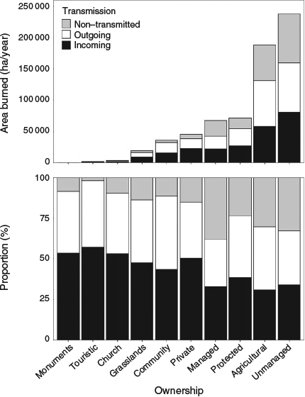
Estimated transmission provides an understanding of who owns the fire risk. Unmanaged and agricultural lands cover 57% of Chalkidiki’s area but receive 64% of all fire and transmit 63% of all outgoing fire (Fig. 2). Agricultural and protected lands (23.5 and 8% of Chalkidiki’s area respectively) have a disproportionately high share of outgoing fire when compared with their area (30 and 11% respectively). Managed lands cover 15.5% of Chalkidiki but have a disproportionately smaller share of outgoing (8%) and incoming (11%) fire. The highest percentages of non-transmitted fire occurred on managed (38% of total fire activity), unmanaged (33%), agricultural (30%) and protected (24%) lands (Fig. 2, bottom panel).
|
When analysing structure exposure, 32% originated from agricultural lands, followed by unmanaged lands (26%), communities (20%) and protected lands (11%) (Table 1). Land tenures that receive some type of management (private, managed, grasslands and Church) contributed only 10% to the total structure exposure problem, even though they cover 28% of Chalkidiki. The number of normalised structure exposure was higher on protected, tourist and agricultural lands (Table 1).
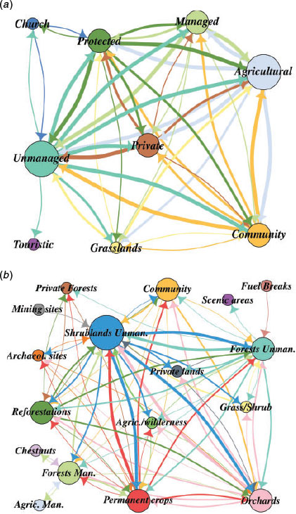
Following these findings, it is important to gain a deeper quantifiable insight on how each land tenure interacts with each neighbour. The large land-tenure transmission network has 44 direct edges (out of 83) and a density of 0.6, i.e. 60% of all possible linkages, whereas the total node degree varied from a low of 4 (Church) to a high of 15 (Unmanaged) (Fig. 3a). Unmanaged lands interacted with all other land tenures; tourist lands received fire mainly from unmanaged lands; and communities were mostly exposed by agricultural and unmanaged lands, followed by protected, managed and private lands. Church lands affected protected and unmanaged lands, while being exposed to fire from agricultural, protected and unmanaged lands. Grasslands and private lands transmitted the most fire to unmanaged and agricultural lands, whereas managed lands transmitted the most fire to unmanaged, agricultural, protected, private and community lands.
|
Fire transmission among land use–land cover types
In Table 1 and Fig. 1b, a breakdown of the 10 land tenures in LULC types reveals the details of fire transmission and structure exposure. The highest amounts of outgoing fire originated from unmanaged shrublands (19.5% of the total outgoing fire), followed by olive trees or orchards (17.5%), unmanaged forests (12.4%) and permanent crops (11.3%). Community WUI covers 5% of Chalkidiki but created 5.6% of all outgoing fire and received 3.7% of all incoming fire. In contrast, agricultural lands that intersect with wild vegetation created 4.8% of all outgoing fire although they cover just the 2.8% of Chalkidiki. Only managed and private forests receive systematic and annual management, whereas the remaining receive sporadic or absent management. Managed forests and private forests (13.5 and 1.6% of Chalkidiki respectively) generated 6.3 and 2% of all outgoing fire respectively. The LULC transmission network has 76 direct edges (out of 328) and a density of 0.28, whereas the total node degree varied from a low of 1 (Mining sites) to a high of 21 (Unmanaged shrublands) (Fig. 3b).
Fire transmission and exposure of communities and monuments
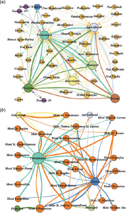
In total, community, tourism and monument areas that cover 7.5% of Chalkidiki received 4.8% of all incoming fire (21 000 ha year−1) and caused 6.5% of all outgoing fire. Most of the top-16 exposed communities (Fig. 4a) are located on the Sithonia peninsula or at the central part of the mainland and they received most fire from agricultural, unmanaged and protected lands. The community transmission network has 135 direct edges (out of 2372) with a density of 0.05, i.e. 5% of all possible linkages (Fig. 5a), with total node degree varying from a low of 1 (e.g. Simantra) to a high of 7 (Ormilia). Most populated places are affected by agricultural lands (21 populated places), followed by unmanaged (18), protected (6), and grasslands and managed lands (2 each).

|
|
Cultural monuments received less fire compared with communities (Fig. 4b), most of which usually came from one to three different land tenures, i.e. unmanaged, Church and agricultural lands. The monument transmission network had 65 direct edges (out of 143) and a density of 0.07, i.e. 7% of all possible linkages (Fig. 5b), with a total node degree varying from a low of 1 (e.g. Monastery (or Moni) St Panteleimonos) to a high of 7 (Skite St Andrea Vatopedinou). Most monuments received fire from unmanaged lands (19 monuments), followed by Church (15 monuments), agricultural lands (4 monuments) and grasslands (4 monuments). Linkages between monuments existed between proximate monuments (e.g. Moni Koutloumousiou with Skite St Panteleimonos), but in general were rare. The WUI of several monuments (Skites of St Andrea Vatopedinou and St Annas; Xilandariou, Theotokou and Koutloumousiou monasteries) caused considerable fire transmission to unmanaged, Church, agricultural and grass covered lands (Fig. 5b).
The amount of fire received by a community was disproportional to the possible number of affected structures (Fig. 4; Table 2). Only three communities that received large amounts of fire (Fig. 4a) also had high amounts of normalised structures affected (i.e. Vourvourou, Ormilia and Ormos Panagias) (Table 2). Normalised structures affected (i.e. how many structures were affected by incoming fire) ranged from a low of 1.78 (Ormos Panagias) to a high of 7.19 (Nea Kalikratia), whereas normalised structure exposure (i.e. how much exposure was created within community boundaries and WUI) ranged from a low of 5.87 (Paralia Neas Triglias) to a high of 11.5 structures year−1 fire−1 (Nea Sermili). Four communities were both sources and sinks of structure exposure (Gigonos, Metoxi 2, Sideri Mantria and Sozopoli). The highest CFL values ranged from a low of 2.25 m to a high of 3.72 m, including one tourism place, one monastery (Moni Simonos Petra) and four skites with values higher than 2.3 m.

|
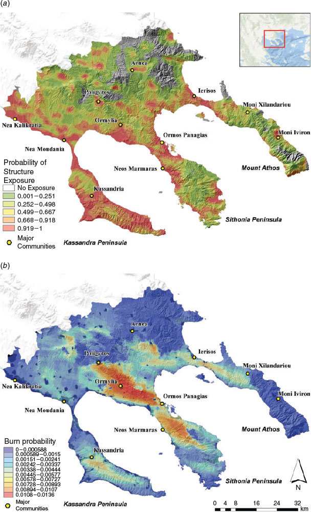
The fireshed map (Fig. 6a) shows that most coastal areas had high potential for generating fires that can cause structure exposure, in particular those in western Chalkidiki and Kassandra peninsula, although they had low burn probability (Fig. 6b). Large areas with zero burn probability (Fig. 6b) were located in the northern and eastern parts of the study area, and low burn probability was predicted for the southern Mount Athos, covered by broadleaf forest, oak and chestnut managed forests. The north part of Sithonia peninsula has the highest burn probability and is mainly composed of agricultural and private landowners, with large parts of unmanaged shrublands and conifer reforestations. Other parts of the study area with high burn probability were in central Kassandra peninsula (conifer reforestations and shrublands) and northern Mount Athos (managed Forest Service lands, reforestations and shrublands with agricultural lands).
|
Discussion
This study offers the first systematic analysis of wildfire transmission in Greece and complements prior wildfire assessments (Kalabokidis et al. 2013, 2015; Mitsopoulos et al. 2015; Mallinis et al. 2016). Our findings can help address deficiencies in the Greek risk-governance system, as highlighted in related studies (Henderson et al. 2005; Morehouse et al. 2011; Tedim et al. 2016). In addition, results can be used to facilitate discussion among policy makers and land managers to better align institutional governance with the biophysical conditions in wildfire prone areas. For instance, areas where fire events are predicted to affect multiple communities or monuments can be prioritised for collaborative approaches to managing fuels.
This work also demonstrated how current management applications (non-fire treatments), or lack thereof, affect exposure. We found that agricultural, unmanaged and protected lands, which all lack active fuels management, have the greatest potential to generate fires that can reach both communities and monuments. Agricultural lands with abandoned or partially managed olive-tree plantations and unmanaged shrublands in proximity to populated places were the sources of the highest wildfire transmission and structure exposure, as measured by outgoing fire and total structures affected (Table 1), causing fast moving, low-to-moderate intensity fires that reached more than half of the communities. Reforested areas in Greece have caused or carried large scale fire events in the past (e.g. Vartholomio, 2007; Evros, 2011; Mount Athos, 2012) and can be expected to do so again because of the lack of required tree thinning and biomass removal (Zagas et al. 2013). The highest normalised structure exposure was observed from events ignited inside reforestations, tourist sites and agricultural lands (Table 1). Tourist sites are mostly forested and in proximity with communities, enabling fires to cross boundaries and threaten structures. Overall, these findings reveal how the lack of fuel management on these lands can expose structures and values-at-risk. In contrast, grasslands, managed and private lands that receive fuel management or disturbance (non-fire treatments, silviculture, wildfire, grazing) affect few communities with a low overall amount of transmitted fire, low annual structure exposure (9.5% of total) and very low exposure per simulated fire.
Our abovementioned findings raise the question of how Greece can manage large areas with high fire risk to communities and monuments, where multiple ownerships coexist and with limited or no funding to perform fuel-reduction management practices. Prior to the major post-war-era land abandonment (MacDonald et al. 2000; Benayas et al. 2007), fire was a widespread practice of local populations employed to clear forests from unwanted vegetation, the absence of which (through legal ban) has caused forest encroachment in formerly agricultural lands (Zakkak et al. 2014; Tedim et al. 2015). Reintroducing fire as a management tool may be an important cost-effective strategy in resolving several ecological and management challenges on the Greek landscape, but further analysis is required to locate possible application sites and to assess its effectiveness on reducing fire spread rates and intensity. Prescribed fire is already applied in Portugal (Fernandes and Botelho 2004), Spain (Vélez 2010), France (Lambert 2010) and Italy (Ascoli and Bovio 2013). Legal frameworks and professional accreditation schemes for the use of fire currently exist in France and Portugal (Montiel and Kraus 2010) and can be used as examples for Greece.
It is also important to reconsider how the existing Greek wildfire risk-assessment system ratings define the locations of high hazard and fire management planning zones. There are major potential shortfalls because these ratings do not consider risk from large fires, the potential exposure created by these events or the impact of wildfire intensity on ecosystems or human communities in a detailed spatial context (Miller and Ager 2013). The integration of the proposed methodology at a regional level in the national risk assessment plan can provide quantitative metrics of exposure and vulnerability, similar to other studies in Italy (Salis et al. 2015; Lozano et al. 2017) and France (Ager et al. 2014). To develop a new national strategy, it is necessary to understand the differences and similarities of both wildfire behaviour and biophysical context across the country’s different regions.
Finally, management of Church lands around monuments is limited by the complex land ownerships network that lacks a coordinated approach from one authority. Each monastery is an autonomous community, meaning that it creates a unique ownership that makes its own management decisions (Alexopoulos 2013). These decisions can create conflicts with the interests of other monasteries (Kermeli 2008). As a result, and based on a Christian religious practice to avoid conflicts among the different autonomous Christian communities, landscapes are usually left unaltered. We assessed the landscape scale wildfire exposure of all major Mount Athos cultural monuments (Fig. 4b, 5b), and collaborative actions among monasteries and the Forest Service can utilise these results to reduce fire risk on their common fireshed, mainly around Iviron and Xilandariou monasteries.
We believe the types of analyses we presented are an important precursor to advancing a new national fire-management plan in Greece that can potentially address current inefficiencies of wildfire confrontation or management. New challenges and realities stemming from the recent economic problems in Greece urge for establishing a risk-governance system that will engage all possible actors, not only state agencies, in a collaborative, collective and holistic wildfire management scheme. Fire-management plans need to include transboundary assessments that explicitly identify the sources of exposure to communities and other high value targets and prioritise areas with the highest exposure. At the same time, policy discussion is needed to identify where and how fire can be returned to the landscape as a tool to manage fuels and restore ecological condition of fire adapted natural areas (Naveh 1975; Arianoutsou 1998; Arianoutsou et al. 2010). Future research will estimate the spatial scale and effectiveness of different fuel management practices and prioritisation scenarios on selected areas, proposing possible fuel treatment prescriptions that can reduce implementation costs and increase the effectiveness of fire containment.
Conflicts of interest
The authors declare that they have no conflicts of interest.
Acknowledgements
We thank Fermin Alcasena for his help in wildfire modelling calibration, Ken Bunzel for developing tools that enabled the post processing of simulation outputs, and Michelle Day for her edits and recommendations. This study was conducted and funded by the US Forest Service International Visitor Program. Authors also thank the anonymous reviewers for their suggestions and comments.
References
Ager AA, Finney MA (2009) Application of wildfire simulation models for risk analysis. Geophysical Research Abstracts 11, EGU2009–EGU5489.Ager AA, Preisler HK, Arca B, Spano D, Salis M (2014) Wildfire risk estimation in the Mediterranean area. Environmetrics 25, 384–396.
| Wildfire risk estimation in the Mediterranean area.Crossref | GoogleScholarGoogle Scholar |
Ager AA, Barros A, Day MA (2015a) Understanding the transmission of wildfire risk on a fire prone landscape: a case study from Central Oregon. Geophysical Research Abstracts 17, EGU2015–EGU15128.
Ager AA, Kline J, Fischer AP (2015b) Coupling the biophysical and social dimensions of wildfire risk to improve wildfire mitigation planning. Risk Analysis 35, 1393–1406.
| Coupling the biophysical and social dimensions of wildfire risk to improve wildfire mitigation planning.Crossref | GoogleScholarGoogle Scholar |
Ager AA, Evers CR, Day MA, Preisler HK, Barros AM, Nielsen-Pincus M (2017) Network analysis of wildfire transmission and implications for risk governance. PLoS One 12, e0172867
| Network analysis of wildfire transmission and implications for risk governance.Crossref | GoogleScholarGoogle Scholar |
Alcasena FJ, Salis M, Ager AA, Arca B, Molina D, Spano D (2015) Assessing landscape scale wildfire exposure for highly valued resources in a Mediterranean area. Environmental Management 55, 1200–1216.
| Assessing landscape scale wildfire exposure for highly valued resources in a Mediterranean area.Crossref | GoogleScholarGoogle Scholar |
Alcasena FJ, Salis M, Vega-García C (2016) A fire modeling approach to assess wildfire exposure of valued resources in central Navarra, Spain. European Journal of Forest Research 135, 87–107.
| A fire modeling approach to assess wildfire exposure of valued resources in central Navarra, Spain.Crossref | GoogleScholarGoogle Scholar |
Alexopoulos G (2013) Management of living religious heritage: who sets the agenda? The case of the monastic community of Mount Athos. Conservation and Management of Archaeological Sites 15, 59–75.
| Management of living religious heritage: who sets the agenda? The case of the monastic community of Mount Athos.Crossref | GoogleScholarGoogle Scholar |
Arianoutsou M (1998) Aspects of demography in post-fire Mediterranean plant communities of Greece. In ‘Landscape Disturbance and Biodiversity in Mediterranean-Type Ecosystems’. pp. 273–295. (Springer)
Arianoutsou M, Christopoulou A, Kazanis D, Tountas T, Ganou E, Bazos I, Kokkoris Y (2010) Effects of fire on high altitude coniferous forests of Greece. In ‘VI International Forest Fire Research Conference’, Coimbra, Portugal, 15–18 November 2010. (Ed. DX Viegas) (ADAI//CEIF: Coimbra, Portugal) Available at http://www.uaeco.edu.gr/files/PDF/int_conf_proc/41_Arianoutsou_et_al.2010.pdf [Verified 6 July 2018]
Ascoli D, Bovio G (2013) Prescribed burning in Italy: issues, advances and challenges. iForest - Biogeosciences and Forestry 6, 79–89.
Bar-Massada A, Stewart SI, Hammer RB, Mockrin MH, Radeloff VC (2013) Using structure locations as a basis for mapping the wildland–urban interface. Journal of Environmental Management 128, 540–547.
| Using structure locations as a basis for mapping the wildland–urban interface.Crossref | GoogleScholarGoogle Scholar |
Benayas JR, Martins A, Nicolau JM, Schulz JJ (2007) Abandonment of agricultural land: an overview of drivers and consequences. Perspectives in Agriculture, Veterinary Science, Nutrition and Natural Resources 2, 1–14.
Borgatti SP, Everett MG, Johnson JC (2013) ‘Analyzing Social Networks.’ (Sage Publications: Thousand Oaks, CA)
Busby GM, Albers HJ, Montgomery CA (2012) Wildfire risk management in a landscape with fragmented ownership and spatial interactions. Land Economics 88, 496–517.
| Wildfire risk management in a landscape with fragmented ownership and spatial interactions.Crossref | GoogleScholarGoogle Scholar |
Busby G, Amacher GS, Haight RG (2013) The social costs of homeowner decisions in fire-prone communities: information, insurance, and amenities. Ecological Economics 92, 104–113.
| The social costs of homeowner decisions in fire-prone communities: information, insurance, and amenities.Crossref | GoogleScholarGoogle Scholar |
Butry D, Donovan G (2008) Protect thy neighbor: investigating the spatial externalities of community wildfire hazard mitigation. Forest Science 54, 417–428.
Crowley CS, Malik AS, Amacher GS, Haight RG (2009) Adjacency externalities and forest fire prevention. Land Economics 85, 162–185.
| Adjacency externalities and forest fire prevention.Crossref | GoogleScholarGoogle Scholar |
Csardi G, Nepusz T (2006) The igraph software package for complex network research. InterJournal, Complex Systems 1695, 1–9.
Curt T, Frejaville T (2017) Wildfire policy in Mediterranean France: how far is it efficient and sustainable? Risk Analysis 38, 472–488.
| Wildfire policy in Mediterranean France: how far is it efficient and sustainable?Crossref | GoogleScholarGoogle Scholar |
EEA (2013) Corine Land Cover (CLC) 2012, Version 18.5.1. Available at https://land.copernicus.eu/pan-european/corine-land-cover/clc-2012 [Verified 6 July 2018]
ESRI (2017) How Kriging works. Available at http://desktop.arcgis.com/en/arcmap/10.3/tools/spatial-analyst-toolbox/how-kriging-works.htm#GUID-94A34A70-DBCF-4B23-A198-BB50FB955DC0 [Verified 14 June 2018]
Fernandes P, Botelho H (2004) Analysis of the prescribed burning practice in the pine forest of northwestern Portugal. Journal of Environmental Management 70, 15–26.
| Analysis of the prescribed burning practice in the pine forest of northwestern Portugal.Crossref | GoogleScholarGoogle Scholar |
Finney MA (2002) Fire growth using minimum travel time methods. Canadian Journal of Forest Research 32, 1420–1424.
| Fire growth using minimum travel time methods.Crossref | GoogleScholarGoogle Scholar |
Fischer AP, Charnley S (2012) Risk and cooperation: managing hazardous fuel in mixed ownership landscapes. Environmental Management 49, 1192–1207.
| Risk and cooperation: managing hazardous fuel in mixed ownership landscapes.Crossref | GoogleScholarGoogle Scholar |
Hellenic Republic MoI (2016) Greek Fire Service Budget allocation. Available at https://et.diavgeia.gov.gr/decision/view/%CE%A8%CE%A0%CE%9E2465%CE%A6%CE%98%CE%95-%CE%9D2%CE%A9 [Verified 14 June 2018]
Henderson M, Kalabokidis K, Marmaras E, Konstantinidis P, Marangudakis M (2005) Fire and society: a comparative analysis of wildfire in Greece and the United States. Human Ecology Review 12, 169–182.
Kalabokidis K, Iosifides T, Henderson M, Morehouse B (2008) Wildfire policy and use of science in the context of a socio-ecological system on the Aegean Archipelago. Environmental Science & Policy 11, 408–421.
| Wildfire policy and use of science in the context of a socio-ecological system on the Aegean Archipelago.Crossref | GoogleScholarGoogle Scholar |
Kalabokidis K, Palaiologou P, Finney MA (2013) Fire behavior simulation in Mediterranean forests using the minimum travel time algorithm. In ‘Proceedings of 4th Fire Behavior and Fuels Conference – At the Crossroads: Looking Toward the Future in a Changing Environment’, 1–4 July 2013, St Petersburg, Russia. pp. 468–492. (International Association of Wildland Fire: Missoula, MT, USA)
Kalabokidis K, Palaiologou P, Gerasopoulos E, Giannakopoulos C, Kostopoulou E, Zerefos C (2015) Effect of climate change projections on forest fire behavior and values-at-risk in southwestern Greece. Forests 6, 2214–2240.
| Effect of climate change projections on forest fire behavior and values-at-risk in southwestern Greece.Crossref | GoogleScholarGoogle Scholar |
Kalabokidis K, Ager AA, Finney MA, Athanasis N, Palaiologou P, Vasilakos C (2016) AEGIS: a wildfire prevention and management information system. Natural Hazards and Earth System Sciences 16, 643–661.
| AEGIS: a wildfire prevention and management information system.Crossref | GoogleScholarGoogle Scholar |
Karali A, Hatzaki M, Giannakopoulos C, Roussos A, Xanthopoulos G, Tenentes V (2014) Sensitivity and evaluation of current fire risk and future projections due to climate change: the case study of Greece. Natural Hazards and Earth System Sciences 14, 143–153.
| Sensitivity and evaluation of current fire risk and future projections due to climate change: the case study of Greece.Crossref | GoogleScholarGoogle Scholar |
Kavvadias VA, Alifragis D, Tsiontsis A, Brofas G, Stamatelos G (2001) Litterfall, litter accumulation and litter decomposition rates in four forest ecosystems in northern Greece. Forest Ecology and Management 144, 113–127.
| Litterfall, litter accumulation and litter decomposition rates in four forest ecosystems in northern Greece.Crossref | GoogleScholarGoogle Scholar |
Kermeli E (2008) Central administration versus provincial arbitrary governance: Patmos and Mount Athos monasteries in the 16th century. Byzantine and Modern Greek Studies 32, 189–202.
| Central administration versus provincial arbitrary governance: Patmos and Mount Athos monasteries in the 16th century.Crossref | GoogleScholarGoogle Scholar |
Konoshima M, Montgomery CA, Albers HJ, Arthur JL (2008) Spatial-endogenous fire risk and efficient fuel management and timber harvest. Land Economics 84, 449–468.
| Spatial-endogenous fire risk and efficient fuel management and timber harvest.Crossref | GoogleScholarGoogle Scholar |
Koutsias N, Arianoutsou M, Kallimanis AS, Mallinis G, Halley JM, Dimopoulos P (2012) Where did the fires burn in Peloponnisos, Greece, the summer of 2007? Evidence for a synergy of fuel and weather. Agricultural and Forest Meteorology 156, 41–53.
| Where did the fires burn in Peloponnisos, Greece, the summer of 2007? Evidence for a synergy of fuel and weather.Crossref | GoogleScholarGoogle Scholar |
Lambert B (2010) The French prescribed burning network and its professional team in Pyrénées Orientales: lessons drawn from 20 years of experience. In ‘Best Practices of Fire Use Prescribed Burning and Suppression Fire Programmes in Selected Case-Study Regions in Europe’. (Eds C Montiel, D Kraus) Research Report 24, pp. 89–106. (European Forest Institute: Porvoo, Finland)
Lozano O, Salis M, Ager AA, Arca B, Alcasena FJ, Monteiro A, Finney MA, Del Guiudice L, Scoccimarro E, Spano D (2017) Assessing climate change impacts on wildfire exposure in Mediterranean areas. Risk Analysis 37, 1898–1916.
| Assessing climate change impacts on wildfire exposure in Mediterranean areas.Crossref | GoogleScholarGoogle Scholar |
MacDonald D, Crabtree JR, Wiesinger G, Dax T, Stamou N, Fleury P, Gutierrez Lazpita J, Gibon A (2000) Agricultural abandonment in mountain areas of Europe: environmental consequences and policy response. Journal of Environmental Management 59, 47–69.
| Agricultural abandonment in mountain areas of Europe: environmental consequences and policy response.Crossref | GoogleScholarGoogle Scholar |
Mallinis G, Mitsopoulos I, Beltran E, Goldammer J (2016) Assessing wildfire risk in cultural heritage properties using high spatial and temporal resolution satellite imagery and spatially explicit fire simulations: the case of Holy Mount Athos, Greece. Forests 7, 46
| Assessing wildfire risk in cultural heritage properties using high spatial and temporal resolution satellite imagery and spatially explicit fire simulations: the case of Holy Mount Athos, Greece.Crossref | GoogleScholarGoogle Scholar |
Miller C, Ager AA (2013) A review of recent advances in risk analysis for wildfire management. International Journal of Wildland Fire 22, 1–14.
| A review of recent advances in risk analysis for wildfire management.Crossref | GoogleScholarGoogle Scholar |
Mitsopoulos I, Mallinis G, Arianoutsou M (2015) Wildfire risk assessment in a typical Mediterranean wildland–urban interface of Greece. Environmental Management 55, 900–915.
| Wildfire risk assessment in a typical Mediterranean wildland–urban interface of Greece.Crossref | GoogleScholarGoogle Scholar |
Montiel C, Kraus DT (2010) ‘Best Practices of Fire Use: Prescribed Burning and Suppression: Fire Programmes in Selected Case-Study Regions in Europe.’ (European Forest Institute: Porvoo, Finland)
Morehouse BJ, Henderson M, Kalabokidis K, Iosifides T (2011) wildland fire governance: perspectives from Greece. Journal of Environmental Policy and Planning 13, 349–371.
| wildland fire governance: perspectives from Greece.Crossref | GoogleScholarGoogle Scholar |
Moreira F, Viedma O, Arianoutsou M, Curt T, Koutsias N, Rigolot E, Barbati A, Corona P, Vaz P, Xanthopoulous G, Mouillot F, Bilgili E (2011) Landscape–wildfire interactions in southern Europe: Implications for landscape management. Journal of Environmental Management 92, 2389–2402.
| Landscape–wildfire interactions in southern Europe: Implications for landscape management.Crossref | GoogleScholarGoogle Scholar |
Naveh Z (1975) The evolutionary significance of fire in the Mediterranean region. Vegetatio 29, 199–208.
| The evolutionary significance of fire in the Mediterranean region.Crossref | GoogleScholarGoogle Scholar |
Papanastasis VP (2004) Traditional vs contemporary management of Mediterranean vegetation: the case of the island of Crete. Journal of Biological Research 1, 39–46.
Salis M, Ager AA, Alcasena FJ, Arca B, Finney MA, Pellizzaro G, Spano D (2015) Analyzing seasonal patterns of wildfire exposure factors in Sardinia, Italy. Environmental Monitoring and Assessment 187, 4175
| Analyzing seasonal patterns of wildfire exposure factors in Sardinia, Italy.Crossref | GoogleScholarGoogle Scholar |
Salis M, Laconi M, Ager AA, Alcasena FJ, Arca B, Lozano O, Fernandes de Oliveira A, Spano D (2016) Evaluating alternative fuel treatment strategies to reduce wildfire losses in a Mediterranean area. Forest Ecology and Management 368, 207–221.
| Evaluating alternative fuel treatment strategies to reduce wildfire losses in a Mediterranean area.Crossref | GoogleScholarGoogle Scholar |
Salis M, Del Guiudice L, Arca B, Ager AA, Alcasena F, Lozano O, Bacciu V, Spano D, Duce P (2018) Modeling the effects of different fuel treatment mosaics on wildfire spread and behavior in a Mediterranean agro-pastoral area. Journal of Environmental Management 212, 490–505.
| Modeling the effects of different fuel treatment mosaics on wildfire spread and behavior in a Mediterranean agro-pastoral area.Crossref | GoogleScholarGoogle Scholar |
Sapountzaki K, Wanczura S, Casertano G, Greiving S, Xanthopoulos G, Ferrara FF (2011) Disconnected policies and actors and the missing role of spatial planning throughout the risk management cycle. Natural Hazards 59, 1445–1474.
| Disconnected policies and actors and the missing role of spatial planning throughout the risk management cycle.Crossref | GoogleScholarGoogle Scholar |
Scott JH, Burgan RE (2005) Standard fire behavior fuel models: a comprehensive set for use with Rothermel’s Surface Fire Spread model. USDA Forest Service, Rocky Mountain Research Station, General Technical Report RMRS-GTR-153. (Fort Collins, CO, USA) Available at https://www.fs.usda.gov/treesearch/pubs/9521[Verified 14 June 2018]
Scott JH, Thompson MP, Calkin DE (2013) A wildfire risk assessment framework for land and resource management. USDA Forest Service, Rocky Mountain Research Station, General Technical Report RMRS-GTR-315 (Fort Collins, CO, USA)
Scott JH, Thompson MP, Gilbertson-Day JW (2017) Exploring how alternative mapping approaches influence fireshed assessment and human community exposure to wildfire. GeoJournal 82, 201–215.
| Exploring how alternative mapping approaches influence fireshed assessment and human community exposure to wildfire.Crossref | GoogleScholarGoogle Scholar |
Tedim F, Xanthopoulos G, Leone V (2015) Chapter 5 – Forest fires in europe: facts and challenges A2 – Shroder, John F. In ‘Wildfire Hazards, Risks and Disasters’. (Ed. D Paton) pp. 77–99. (Elsevier: Oxford, UK)
Tedim F, Leone V, Xanthopoulos G (2016) A wildfire risk management concept based on a social–ecological approach in the European Union: fire smart territory. International Journal of Disaster Risk Reduction 18, 138–153.
| A wildfire risk management concept based on a social–ecological approach in the European Union: fire smart territory.Crossref | GoogleScholarGoogle Scholar |
Triantakonstantis DP, Kollias VJ, Kalivas DP (2006) Forest re-growth since 1945 in the Dadia Forest Nature Reserve in Northern Greece. New Forests 32, 51–69.
| Forest re-growth since 1945 in the Dadia Forest Nature Reserve in Northern Greece.Crossref | GoogleScholarGoogle Scholar |
Tsitsoni T (1997) Conditions determining natural regeneration after wildfires in the Pinus halepensis (Miller, 1768) forests of Kassandra Peninsula (North Greece). Forest Ecology and Management 92, 199–208.
| Conditions determining natural regeneration after wildfires in the Pinus halepensis (Miller, 1768) forests of Kassandra Peninsula (North Greece).Crossref | GoogleScholarGoogle Scholar |
Vélez R (2010) Prescribed burning for improved grazing and social fire prevention: the Spanish EPRIF Programme. In ‘Best Practices of Fire Use Prescribed Burning and Suppression Fire Programmes in Selected Case-Study Regions in Europe’. (Eds C Montiel, D Kraus) Research Report 24, pp. 107–122. (European Forest Institute: Porvoo, Finland)
Xanthopoulos G (2004) Who should be responsible for forest fires? Lessons from the Greek experience. In ‘Proceedings of the Second International Symposium on Fire Economics, Planning and Policy: a Global View’, April 2008, Córdoba, Spain. US Department of Agriculture, Forest Service, Pacific Southwest Research Station, General Technical Report PSW-GTR-208, pp. 189–201. (Albany, CA, USA)
Xanthopoulos G, Caballero D, Galante M, Alexandrian D, Rigolot E, Marzano R (2006) Forest fuels management in Europe. In ‘Fuels Management – How to Measure Success’, 28–30 March 2006, Portland, OR, USA. (Eds PL Andrews, BW Butler) US Department of Agriculture, Forest Service, Rocky Mountain Research Station, Proceedings RMRS-P-41, pp. 29–46. (Fort Collins, CO, USA)
Zagas T, Raptis D, Zagas D, Karamanolis D (2013) Planning and assessing the effectiveness of traditional silvicultural treatments for mitigating wildfire hazard in pine woodlands of Greece. Natural Hazards 65, 545–561.
| Planning and assessing the effectiveness of traditional silvicultural treatments for mitigating wildfire hazard in pine woodlands of Greece.Crossref | GoogleScholarGoogle Scholar |
Zakkak S, Kakalis E, Radović A, Halley JM, Kati V (2014) The impact of forest encroachment after agricultural land abandonment on passerine bird communities: The case of Greece. Journal for Nature Conservation 22, 157–165.
| The impact of forest encroachment after agricultural land abandonment on passerine bird communities: The case of Greece.Crossref | GoogleScholarGoogle Scholar |